


Chapter 20.44
GENERAL DEVELOPMENT STANDARDS
Sections:
20.44.020 TRADITIONAL FRONT YARD.
20.44.050 ALTERNATIVE SETBACKS.
20.44.060 ACCESSORY STRUCTURE SETBACKS.
20.44.070 MEASURING THE HEIGHT OF A STRUCTURE.
20.44.080 CALCULATING LOT AREA.
20.44.090 ROUNDING OF FRACTIONS.
20.44.110 LIGHTING REGULATIONS.
20.44.120 DRIVE-THROUGH FACILITIES.
20.44.010 FRONT YARD.
(a) The front yard is the area extending the full width of the front of a lot between the front lot line and the front building line. (See Figure 20.44(a) for an illustration of front yards.) Structure intrusions into front yard setbacks are prohibited except:
(1) Eaves, cornices, awnings, bay windows, architectural appendages, fireplaces, and chimneys and may project not more than two (2) feet into the front yard setback;
(2) Decks, platforms, porches, steps, walkways, and driveways that do not exceed thirty (30) inches in height above the finished grade;
(3) Raised decks, high or covered porches, balconies or similar architectural appendages that extend more than thirty (30) inches above finished grade may project not more than six (6) feet into the front yard setback;
(4) Fences and freestanding walls that meet the requirements set forth in BMC 20.46.020 may be allowed.
(b) Front yard setbacks shall be applied in the following manner for through lots:
(1) Through Lot. A through lot has two (2) front lot lines parallel or approximately parallel to each other. The front yard setback shall apply to each front lot line, except the Director may designate one (1) of the front lot lines a rear lot line, provided the following criteria are met:
(i) Orientation of the lot or structure shall be considered;
(ii) At least sixty (60) percent of the lots or structures within the neighborhood block, or area being considered, are oriented in a similar direction away from the lot line being designated as a rear lot line;
(2) Corner Lots. Corner lots have abutting streets that intersect. The front yard setbacks shall apply to each front property line.
(3) Exceptions. When a property contains three (3) or more front yards, the Director may grant exceptions to maximum front yard setback requirements provided:
(i) The maximum front yard setback continues to be applied to at least two (2) front yards that intersect each other;
(ii) Relief is necessary to facilitate good design; and
(iii) A strict application of the setback requirement would result in larger structures that are not practical for the intended use of the site. (Ord. 5301 §3 (Exh. B) (part), 2016: Ord. 4950 §8 (Exh. A) (part), 2005)
20.44.020 TRADITIONAL FRONT YARD.
In residential zones, the Director may grant modifications to the front yard setback provided:
(a) Sixty (60) percent or more of the houses or garages/carports within a numbered block on the same side of the street as the subject property are set back less than the required zoning front yard setback; the average setback of the existing nonconforming structures may be used to establish the minimum front yard of all properties fronting on that side of the street; and
(b) The minimum front yard setback shall in no case be less than five (5) feet. No portion of the primary structure shall enter within five (5) feet of the front property line, except as provided in BMC 20.44.010(a)(2). (Ord. 5319 §5, 2017: Ord. 5301 §3 (Exh. B) (part), 2016: Ord. 4950 §8 (Exh. A) (part), 2005)
20.44.030 SIDE YARD.
The side yard is the area extending between the side lot line and the side building line and extends from the front yard to the rear yard. Triangle lots, corner lots and other irregular lots may have only front and side yards and no rear yards. Structure intrusions into side yard setbacks are prohibited except:
(a) Eaves, cornices, awnings, fireplaces, and chimneys may project not more than two (2) feet into the side yard setback;
(b) Platforms, steps, walkways, and driveways (does not include parking spaces) that do not exceed thirty (30) inches in height above the finished grade; and
(c) Fences and freestanding walls that meet the requirements set forth in BMC 20.46.020. (Ord. 5301 §3 (Exh. B) (part), 2016: Ord. 4950 §8 (Exh. A) (part), 2005)
20.44.040 REAR YARD.
The rear yard is the area extending the full width of the lot between the rear lot line and the rear building line. Structure intrusions into rear yard setbacks are prohibited except:
(a) Eaves, cornices, awnings, architectural appendages, fireplaces, and chimneys and may extend no more than two (2) feet into the required rear yard area setback, and are no closer than three (3) feet from any lot line.
(b) Decks, platforms and open, uncovered porches, provided they do not exceed thirty (30) inches in height above the finished grade and are no closer than three (3) feet from any lot line.
(c) Raised decks, high or covered porches, balconies or similar architectural appendages that extend more than thirty (30) inches above finished grade may project not more than six (6) feet into the rear yard setback.
(d) Fences and freestanding walls that meet the requirements set forth in BMC 20.46.020; and steps, walks and driveways, provided they do not exceed thirty (30) inches in height above the finished grade. (Ord. 5301 §3 (Exh. B) (part), 2016: Ord. 4950 §8 (Exh. A) (part), 2005)
20.44.050 ALTERNATIVE SETBACKS.
The Director may approve alternative setbacks that generate a public benefit, provided the following criteria are satisfied:
(a) Total site area within setbacks shall be equal to or exceed that created by adherence to the standard setbacks;
(b) There shall be a finding of public benefit that is consistent with the goals and policies of the Comprehensive Plan. An example of public benefit includes but is not limited to reduction of setback adjacent to a street or other public right-of-way in exchange for increased setback from a development-sensitive environment such as a wetland or an existing incompatible land use; and
(c) The development plan shall not be inconsistent with the intent of any provision of the zoning code. (Ord. 5301 §3 (Exh. B) (part), 2016: Ord. 4950 §8 (Exh. A) (part), 2005)
20.44.060 ACCESSORY STRUCTURE SETBACKS.
(a) Accessory structures shall observe the front yard setback requirements of the zone in which they are located except for intrusions per BMC 20.44.010, 20.44.030, and 20.44.040.
(b) Accessory structures in residential zoning districts may be constructed no closer than three (3) feet from the side or rear property lines that adjoin other property. No setback is required if the side or rear property line adjoins an alley. (Ord. 5301 §3 (Exh. B) (part), 2016: Ord. 4971 §5, 2006: Ord. 4950 §8 (Exh. A) (part), 2005)
20.44.070 MEASURING THE HEIGHT OF A STRUCTURE.
The height of a building or structure shall be measured as the vertical distance from grade plane to the average height of the highest roof surface. Exceptions: penthouse for elevators, firewalls, chimneys, flagpoles, and wireless communications facilities in conformance with BMC 20.46.140 may exceed maximum height limits. None of these exceptions to the height regulations shall be used for advertising of any kind. (Ord. 5319 §6, 2017: Ord. 5301 §3 (Exh. B) (part), 2016: Ord. 4950 §8 (Exh. A) (part), 2005)
20.44.080 CALCULATING LOT AREA.
Lot area shall include all areas within the exterior lot lines less any water areas, wetlands and other areas that may be restricted from use or from the types of development allowed by the zone in which the property is located. Lot widths, depths and setbacks on shoreline lots are measured from the ordinary high water mark. (See Figure 20.44(b) for an illustration of measuring lot area.) (Ord. 5301 §3 (Exh. B) (part), 2016: Ord. 4950 §8 (Exh. A) (part), 2005)
20.44.090 ROUNDING OF FRACTIONS.
In several instances throughout the code, the number of units allowed may end in a fraction due to the mathematical equation used to determine allowable units. For instance, the number of dwelling units allowed on property using density calculations is determined by dividing the lot size by the number of square feet permitted per dwelling unit. When this number results in a fraction, round up to the next whole number (unit) when the fraction of whole number is at least 0.50. In no case shall setback requirements be rounded. (Ord. 5301 §3 (Exh. B) (part), 2016: Ord. 4971 §6, 2006: Ord. 4950 §8 (Exh. A) (part), 2005)
20.44.100 FLAG LOTS.
A flag lot is defined as a lot with access to a street by way of a narrow strip of land. The lot consists of two (2) parts: the "flag" or main body of the lot and the "panhandle" or the narrow accessway connecting the lot to the street.
(a) When creating new lots the following standards shall apply:
(1) The minimum lot size shall be one hundred and fifty (150) percent of the minimum lot size of the underlying zone;
(2) The "panhandle" shall have a minimum width of twenty (20) feet;
(3) The minimum lot width and depth of the "flag" shall be the same as the underlying zone.
(b) Flag lot dimensions shall be measured from the midpoint between two (2) opposite lot lines of the "flag" body of the lot.
(c) The yard setbacks shall be the same as underlying zone setbacks, except the front yard setback area shall be applied per Figure 20.44(a).
(d) In those cases where subsection (c) of this section cannot be applied, the property line that most closely parallels the street from which the lot gains its access shall be deemed the front lot line and front yard setbacks shall be measured from that line.
(e) The accessway or driveway shall be under the same ownership as the body of the flag lot. An easement shall not be used as a method of providing access to the body of the flag lot.
(f) The panhandle shall provide access to a paved and dedicated public right-of-way or a private street. Flag lots shall not be created in order to avoid providing turnarounds per City engineering street standards. (Ord. 5301 §3 (Exh. B) (part), 2016: Ord. 4950 §8 (Exh. A) (part), 2005)
20.44.110 LIGHTING REGULATIONS.
The following requirements shall apply concerning exterior lighting:
(a) Light sources, both direct and nondirect, shall be selected and placed so that glare produced by any light source does not extend beyond the property lines, except onto adjacent sidewalks.
(b) A photometric plan shall be submitted for all nonresidential development and multiple-family developments to confirm compliance with light requirements. The plan shall include the following items:
(1) Location of all lighting fixtures;
(2) Manufacturer’s model identification of each lighting fixture;
(3) Manufacturer’s performance specifications of each fixture; and
(4) Photometric plan of the installed fixtures which demonstrates that all illumination is confined within the boundaries of the site. (Ord. 5301 §3 (Exh. B) (part), 2016: Ord. 4950 §8 (Exh. A) (part), 2005)
20.44.120 DRIVE-THROUGH FACILITIES.
(a) Intent. The standards of this section regulate the installation of drive-through facilities to ensure their design, operation, and associated impacts can effectively be mitigated. The purpose of this section is to permit drive-through facilities only when they:
(1) Provide safe and efficient and on-site vehicular and pedestrian circulation;
(2) Minimize conflicts between queued vehicles and traffic on adjacent streets and sidewalks; and
(3) Reduce impacts on abutting uses, such as noise, visual, and light, particularly to residential uses.
(b) Applicability. Drive-through facility standards within this section apply to the construction of new or modified drive-through facilities. Drive-through facilities are only allowed when found in association with a permitted use in commercial, mixed-use, or industrial zones, unless drive-through facilities are expressly prohibited in the zoning districts regardless of the principal use.
(c) Procedure. All new or altered drive-through facilities shall be processed per the underlying permit type per Chapter 20.02 BMC. Approval of a drive-through facility may be granted through either:
(1) An administrative Type I Director’s decision or concurrently with another permit as regulated by Chapter 20.02 BMC, when the proposed facility meets all criteria established per subsection (e) of this section; or
(2) A Type III conditional use permit per BMC 20.58.020 is required when a proposal seeks alternatives to any of the criteria established per subsection (e) of this section. The Hearing Examiner may approve alternatives to criteria presented in this section when the following are met:
(i) Any proposal to modify drive-through facility standards shall not undermine the intent of this section or that of the underlying zone.
(ii) Proposals seeking a drive aisle between a primary frontage and the building shall demonstrate that all other site designs have been exhausted and found unworkable.
(iii) The applicant shall demonstrate how the proposed alternative fully screens neighboring properties, that the total amount of landscaping exceeds the total amount of that created by adherence to standard landscaping and buffer requirements.
(iv) A public amenity shall be provided. Examples of public amenities include: outdoor eating area, outdoor artwork, street furniture, plantings in window boxes, public trash receptacles, or other alternative public amenity approved by the Hearings Examiner. Any proposed amenity shall be architecturally compatible with the principal structure and shall be maintained for the life of the project.
(v) Conditions such as site orientation, fencing, buffering, parking location, lighting, access, hours of operation, and others may be imposed as a condition of approval if it is found they are necessary to mitigate identifiable adverse impacts and ensure compatibility with nearby uses.
(d) Submittals. Applications shall include the following components; the Director may modify these requirements based on the size, scope and complexity of the project:
(1) Vicinity Map. Showing the subject property in relation to all other properties and major structures within a two hundred fifty (250) foot radius of the property;
(2) Site Plan.
(i) All property lines, easements, fences, walls, signs, and other points of reference.
(ii) Existing and proposed structures, pedestrian walkways, bikeways, parks, playgrounds, recreational areas, and other areas and facilities of a public or recreational nature.
(iii) Existing and proposed utility systems, drainage structures, fire hydrants, and other infrastructure improvements.
(iv) An environmental summary, including such features as shorelines, bulkheads, creeks, culverts, wetlands, steep slopes, and other "sensitive areas," etc.;
(3) Landscape Plan. A plan conforming to Chapter 20.50 BMC and other landscape requirements of this section. This information may be shown on the site plan or may be provided in a separate plan;
(4) Parking Plan. A plan conforming to Chapter 20.48 BMC and other requirements of this section. This information may be shown on the site plan or may be provided in a separate plan;
(5) Applications may require a traffic impact assessment prepared by a qualified professional for the drive-through facility installation. Reports shall demonstrate that stacked vehicles do not impede vehicular or pedestrian traffic on abutting right-of-way, or interfere with the circulation of pedestrians, traffic maneuvering, or other parking space area(s) located on site.
(e) Site Design Requirements. All drive-through facilities shall comply with the following requirements:
(1) Location. All efforts should be taken to locate the drive-through facility towards the side and/or rear of buildings. Drive-through facilities shall not be located between the building and the street frontage except when a site contains more than one (1) street frontage the drive-through facility may be located between the building and secondary frontage. Screening of secondary street frontages shall be a minimum of five (5) feet wide and at least four (4) feet in height.
(2) Stacking. All drive-through facility stacking lanes shall meet the following criteria:
(i) Stacking lanes shall be a minimum of eighty (80) feet behind the ordering board/window, where the order is requested, except for facilities where vehicles do not routinely stack up while waiting for the services, such as ATM-only locations. For restaurant/food/drink uses the stacking lane shall provide room for a minimum of one hundred twenty (120) feet.
(ii) After permitting and during operation, if the drive-through facilities have negative traffic impacts on adjacent roads and/or businesses, the City may require additional traffic controls at the businesses’ expense to alleviate the negative impacts. This could include temporary or permanent solutions.
(3) Design. The drive-through lane(s) shall be designed as a dedicated lane, physically separated from parking areas and internal parking circulation aisles in order to enhance pedestrian safety and provide screening from adjacent properties and right-of-way. A combination of two (2) of the following shall be provided adjacent to the drive-through lane(s):
(i) Landscaped strips, islands, or berms that are a minimum of three (3) feet wide and fifty (50) square feet in size are required in addition to all other required landscaping areas. Said landscaped areas shall include a mix of ground covers and shrubs that act as a barrier between the drive-through lane and adjacent properties, right-of-way, and parking area;
(ii) Hedges, decorative walls, fencing, or trellises that act as a visual barrier between the drive-through lane(s) and adjacent properties, right-of-way and parking areas;
(iii) Decorative pavement, alternative materials (bricks, stamped concrete), or other durable ground treatment that clearly separates the drive-through lane(s) from other driving and parking areas on site that will withstand heavy traffic conditions found in association with drive-through lanes. Paint striping does not meet this requirement;
(iv) When drive-through facilities are open and other pedestrian-oriented customer entrances to the businesses are unavailable, they must serve customers using other modes rather than vehicular. This may be accomplished by online ordering, pickup areas or similar. Such pickup areas shall be illustrated on the submitted site plan.
(4) Signage.
(i) Each ordering location shall have a maximum of one (1) menu board. One (1) additional menu board may be placed adjacent to the stacking lane for patrons waiting behind the ordering station. Each menu board sign shall not exceed thirty (30) square feet and have a maximum height of seven (7) feet.
(ii) Menu boards shall be located in a landscaped strip or island no smaller than three (3) feet wide and fifty (50) square feet in total size. This landscaping area shall be in addition to all other required landscaping. The menu board(s) shall be oriented away from public streets and be intended for viewing by drive-through patrons only. Screening of the menu board may be required when the board is located adjacent to the right-of-way or neighboring properties. Screening shall ensure the board is not readable from the surrounding properties or street.
(5) Pedestrian Features. In order to enhance safe pedestrian access, designated walkways from all on-site parking areas and from the public sidewalk to a building entry shall be provided as follows:
(i) Walkways shall be a minimum five (5) feet in width, clearly marked and easily distinguished from driving surfaces by using a combination of landscaping strips or islands that delineate the pedestrian walkways; and
(ii) Walkways shall include at least one (1) of the following treatments: decorative paving, stamped/stained concrete or raised walkways with alternative materials (such as brick, cobblestone, and decorative pavers) to clearly indicate the safe walking route. Walkways through heavy traffic areas such as the drive-through must be made of durable materials able to withstand heavy traffic conditions. (Ord. 5429 §3, 2021; Ord. 5301 §3 (Exh. B) (part), 2016: Ord. 5222 §4, 2013: Ord. 4950 §8 (Exh. A) (part), 2005)
Figure 20.44(a)
Front Yard Setback Areas
The following figure provides guidance in the application of front yard setback requirements to different types of lot and street configurations.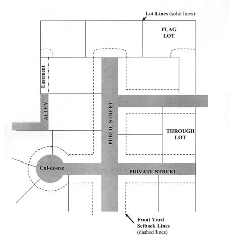
(Ord. 5301 §3 (Exh. B) (part), 2016: Ord. 4950 §8 (Exh. A) (part), 2005)
Figure 20.44(a)
Front Yard Setback Areas
The following figure is for illustration purposes only and serves as a guideline when applying setback requirements.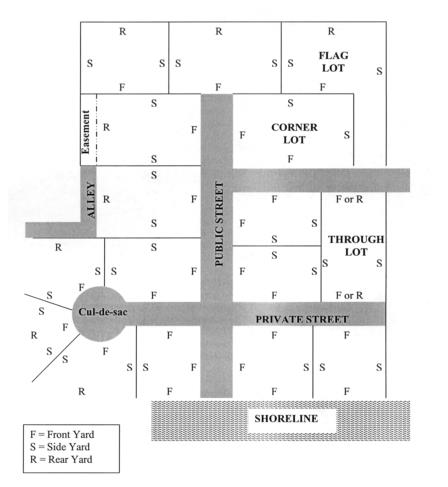
(Ord. 5301 §3 (Exh. B) (part), 2016: Ord. 4950 §8 (Exh. A) (part), 2005)
Figure 20.44(b)
LOT AREA CALCULATIONS
The following illustration demonstrates the methods for calculating lot area in BMC Title 20.
1. The drawing below represents a one (1) acre parcel before deductions from buildable areas. This is the "gross" lot area of the site.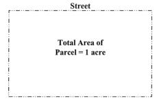
2. When creating new lots, the unbuildable areas such as streets and critical areas are subtracted from the gross lot area to produce a net lot area that is used when calculating the size of each new lot. If a new individual lot contains an unbuildable environmentally sensitive area that is twenty-five (25) percent or less of its gross lot area, the sensitive area may be included in the lot area. The drawing below represents a one (1) acre parcel divided into five (5) parcels with applicable deductions.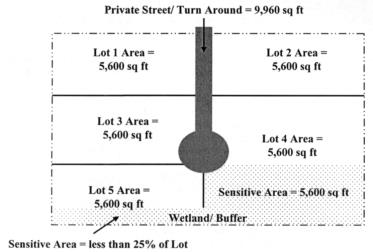
(Ord. 5301 §3 (Exh. B) (part), 2016: Ord. 4950 §8 (Exh. A) (part), 2005)