


Chapter 20.25
SHORELINE ENVIRONMENT DESIGNATIONS
Sections:
20.25.001 Shorelines of statewide significance.
20.25.005 Shoreline environment designation map.
20.25.020 Shoreline residential.
20.25.025 Shoreline environment designation map.
20.25.001 Shorelines of statewide significance.
The State of Washington Shoreline Management Act (SMA) designates certain shoreline areas as shorelines of statewide significance. These shorelines are considered important major resources from which all people in the state derive benefit. The SMA states that local shoreline master programs must give preference to uses which favor public and long-term interests of the people of the state. In the city of Burien, only the marine shorelines below the extreme low tide are designated shorelines of statewide significance. Lake Burien is a “shoreline of the state” and is not a “shoreline of statewide significance.” The following policies apply to Burien’s marine shorelines:
(1) Recognize and protect the statewide interest over local interest.
(2) Preserve the natural character of the shoreline.
(3) Result in long-term over short-term benefit.
(4) Protect the resources and ecology of the shoreline.
(5) Increase public access to publicly owned areas of the shoreline.
(6) Increase recreational opportunities for the public on the shoreline. [Ord. 581 § 1 (Exh. A), 2013]
20.25.005 Shoreline environment designation map.
The shoreline designation map, Figure 3, establishes the general locations of each of the shoreline designations within the city of Burien. This map generally illustrates the extent of shoreline jurisdiction, but is only a depiction that will need to be reviewed and determined on a case-by-case basis based on the relevant definitions in the SMA. In the event that there are any undesignated shorelines of the state, they will be automatically designated “urban conservancy” under this SMP. If any part of a proposed development or activity is located within shoreline designation, the entire proposal must be reviewed for consistency with the city of Burien’s shoreline master program. [Ord. 581 § 1 (Exh. A), 2013]
20.25.010 Aquatic.
(1) Purpose. The purpose of the “aquatic” shoreline environment designation is to protect, restore, and manage the unique characteristics and resources of shoreline areas waterward of the ordinary high water mark, including both Lake Burien and Puget Sound. This is accomplished by managing water-dependent uses and modifications to:
(a) Preserve/restore ecological functions of the nearshore area;
(b) Preserve critical saltwater and freshwater habitat;
(c) Provide public access and recreation opportunities;
(d) Assure compatibility between shoreland and aquatic uses.
(2) Criteria for Designation. An “aquatic” shoreline environment designation is assigned to lands waterward of the ordinary high water mark for both saltwater and freshwater bodies of water, including any submerged or intertidal areas. For the city of Burien, this designation applies to Lake Burien and all marine (Puget Sound) areas waterward of the ordinary high water mark out to the center of the channel within the city limits. The aquatic shoreline environment designation includes the water surface together with the underlying lands and the water column.
(3) Management Policies.
(a) Shoreline uses and modifications should be compatible with the adjoining shoreline environment and designed and managed to prevent degradation of water quality and alteration of natural hydrographic conditions.
(b) New over-water structures should be allowed only for water-dependent uses, public access, or ecological restoration if it can be clearly shown that the cumulative environmental impacts of such structures will not cause significant adverse impacts to protected species.
(c) The size of new over-water structures should be limited to the minimum necessary to support the structure’s intended use and should support multiple uses.
(d) All developments and uses on navigable waters or their beds should be located and designed to minimize interference with surface navigation and moorage.
(e) All developments and uses should consider impacts to public views and access and allow for the safe, unobstructed passage of fish and wildlife, particularly those species dependent on migration.
(f) Restoration opportunities associated with project impacts should be encouraged in the aquatic environment.
(g) Uses that adversely impact the ecological functions of critical saltwater and freshwater habitats should not be allowed except where necessary to achieve the objectives of RCW 90.58.020 (Shoreline Management Act), and then only when their impacts are mitigated according to the sequence described in WAC 173-26-201(2)(e) (Environmental Impact Mitigation) necessary to achieve no net loss of ecological functions.
(h) Shoreline uses and modifications should be designed and managed to prevent degradation of water quality and alteration of natural hydrographic conditions. [Ord. 581 § 1 (Exh. A), 2013]
20.25.015 Urban conservancy.
(1) Purpose. The purpose of the “urban conservancy” shoreline environment designation is to protect and restore ecological functions of open space, floodplains, and other sensitive lands where they exist in urban and developed settings, while allowing a variety of compatible uses. This designation focuses on providing public access for the enjoyment of marine and lake shorelines by allowing the development of public recreational facilities.
(2) Criteria for Designation. An “urban conservancy” environment designation is assigned to areas within shoreline jurisdiction that are suitable for public access, water enjoyment recreational uses and active recreation developments. These are areas that are developed at a low density including residences and outdoor recreation. The urban conservancy environment is bounded on the north by the northern end of Seahurst Park and on the south by the southern end of Eagle Landing Park.
(3) Management Policies.
(a) Uses that preserve or restore the natural character of the shoreline area or promote preservation of open space and critical areas should be the primary allowed uses.
(b) Public access and public recreation objectives should be implemented if feasible and wherever any significant ecological impacts can be mitigated.
(c) Water-oriented uses should be given priority over non-water-oriented uses with water-dependent uses given the highest priority.
(d) New development should be designed and located to preclude the need for shoreline armoring, vegetation removal, flood control, and other shoreline modifications.
(e) Standards should be established for shoreline stabilization measures, vegetation conservation, water quality, and shoreline modifications. These standards shall ensure that new development does not result in a net loss of shoreline ecological functions or further degrade other shoreline values. [Ord. 581 § 1 (Exh. A), 2013]
20.25.020 Shoreline residential.
(1) Purpose. The purpose of the “shoreline residential” environment designation is to accommodate residential development and appurtenant structures as well provide appropriate public access.
(2) Criteria for Designation. A “shoreline residential” environment designation is assigned to shoreline areas that are predominantly single-family or multifamily residential development or are planned and platted for residential development. These are areas that are developed at a moderate density or intensity including residences and outdoor recreation. Low intensity institutional uses may be allowed if their impacts on the shoreline environment are mitigated. The shoreline residential environment includes all shorelands from the northern city limits to the north end of Seahurst Park, from the southern end of Eagle Landing Park to the southern city limits, and all of Lake Burien.
(3) Management Policies.
(a) Residential and accessory uses, recreation facilities and public access shall be the preferred uses.
(b) Multifamily and multi-lot residential and recreational developments should provide public access and joint use for community recreational facilities.
(c) Water-oriented recreational uses should be allowed.
(d) Any new development or redevelopment should utilize low-impact development techniques where feasible.
(e) Standards for building setbacks, lot coverage limitations, riparian buffers, shoreline stabilization, vegetation conservation, critical area protection, and water quality shall be set to assure no net loss of shoreline ecological functions.
(f) Public access and public recreation objectives should be implemented if feasible and wherever any significant ecological impacts can be mitigated. [Ord. 581 § 1 (Exh. A), 2013]
20.25.025 Shoreline environment designation map.
Figure 3: Shoreline Environment Designation Map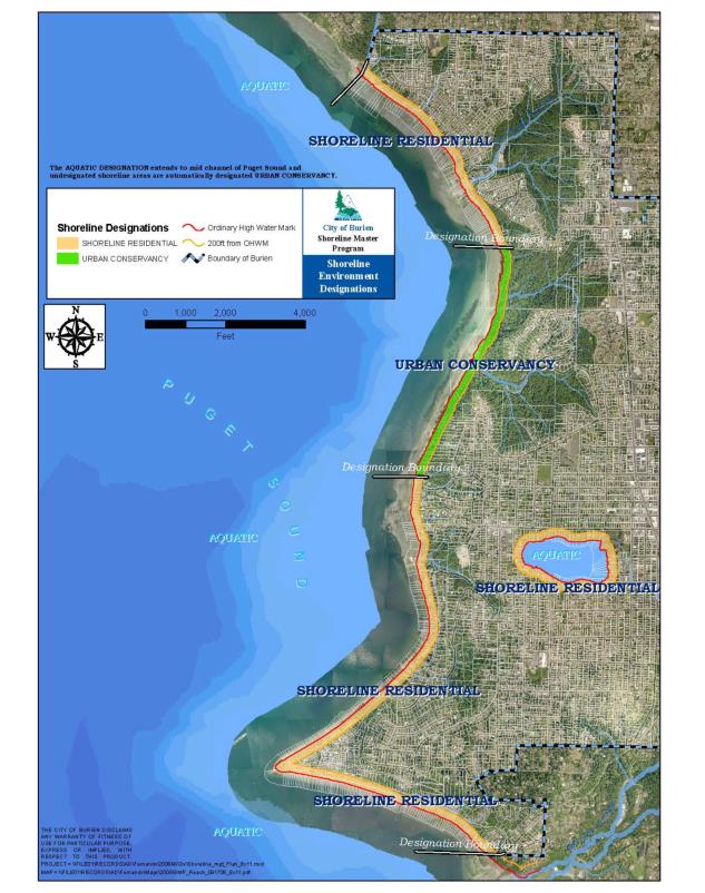
[Ord. 581 § 1 (Exh. A), 2013]