


Chapter 20.30
SHORELINE USES AND MODIFICATIONS POLICIES AND REGULATIONS*
Sections:
20.30.001 Shoreline permit matrix.
20.30.007 Existing development.
20.30.020 Archaeological and historic resources.
20.30.030 Flood hazard reduction.
20.30.040 Shoreline vegetation.
20.30.045 Water quality, storm water and nonpoint pollution.
20.30.050 Dimensional standards for shoreline development.
20.30.060 Select shoreline uses and modifications.
20.30.070 Bulkheads and other shoreline stabilization structures.
20.30.075 Over-water structures – Including docks, piers and floats.
20.30.080 Habitat restoration and enhancement.
20.30.085 Recreational development.
20.30.090 Recreational mooring buoys.
20.30.095 Residential development.
20.30.100 Transportation facilities and parking.
*The appendices referenced in this chapter are available at the city of Burien.
20.30.001 Shoreline permit matrix.
|
Type of Shoreline Permit Required for New Shoreline Uses and Modifications* |
|||
|---|---|---|---|
|
|
Shoreline Environment Designations |
||
|
|
Shoreline Residential |
Aquatic |
Urban Conservancy |
|
Aquaculture |
X |
CU1 |
X |
|
Boat Mooring Buoy |
N/A |
P3 |
N/A |
|
Boat Ramp |
X |
X |
X |
|
Boat House (covered moorage) |
X |
X |
X |
|
Shoreline Stabilization Structures |
|
|
|
|
• Breakwater and Other In-Water Structures |
N/A |
X6 |
N/A |
|
• Bulkheads |
SDP4 |
CU |
SDP4 |
|
• Upland Structures (retaining walls and bluff walls)** |
SDP |
N/A |
SDP |
|
Personal Wireless Service Facility |
CU |
N/A |
X |
|
Community Beach |
CU |
CU |
X |
|
Community Residential Facility |
CU |
X |
X |
|
Docks, Piers and Floats |
CU |
CU |
CU |
|
Docks, Piers and Floats – Residential |
SDP5 |
SDP5 |
X |
|
Dredging |
N/A |
X |
N/A |
|
Fill2 |
X |
X |
X |
|
Floating Home |
N/A |
X |
N/A |
|
Flood Hazard Reduction |
SDP |
CU |
SDP |
|
Forest Practices9 |
CU |
N/A |
CU |
|
Grading |
CU |
N/A |
CU |
|
Government Facility |
CU |
X |
CU |
|
Habitat Enhancement or Restoration |
SDP |
SDP |
SDP |
|
Industrial and Ports |
X |
X |
X |
|
Mining |
X |
X |
X |
|
Office |
X |
X |
X |
|
Public Park and Recreation Facilities |
SDP |
SDP |
SDP |
|
Recreation |
SDP |
SDP |
SDP |
|
Residential – Single-Family** |
SDP8 |
X |
SDP8 |
|
Residential – Multifamily |
SDP |
X |
CU |
|
Commercial Use and Development |
X7 |
X |
X7 |
|
Schools |
CU |
N/A |
CU |
|
Transportation Facilities and Parking |
SDP |
X |
SDP |
|
Utilities |
SDP |
CU |
SDP |
|
P |
Permitted – Allowed when meeting the requirements for the given use. A shoreline substantial development permit (SDP) or shoreline exemption may be needed. See WAC 173-27-040(2) for a complete list of development exempt from a substantial development permit. |
|
SDP |
Shoreline substantial development permit (city decision) – See Chapter 20.35 BMC for specific procedures. |
|
CU |
Shoreline conditional use permit (requires a Department of Ecology decision if locally approved) – See Chapter 20.35 BMC for specific procedures. A SDP may also be required. |
|
X |
Prohibited. |
|
N/A |
Not applicable. |
|
1 |
Prohibited in critical saltwater habitats and Lake Burien. |
|
2 |
Allowed if necessary to construct a permitted use. |
|
3 |
Private mooring buoys are exempt from the shoreline substantial development permit process but shall comply with BMC 20.30.090 (Recreational mooring buoys) which prohibits mooring buoys on Lake Burien. |
|
4 |
Construction of the normal protective bulkhead common to single-family residences must comply with BMC 20.30.070 (Bulkheads and other shoreline stabilization structures) but is not required to obtain a substantial development permit. |
|
5 |
Construction of a dock, including a community dock, designed for pleasure craft only, for the private noncommercial use of the owner, lessee, or contract purchaser of single-family and multiple-family residences, shall not require a substantial development permit if below the thresholds set forth in WAC 173-27-040(2)(h), but shall comply with all other applicable sections of this master program. |
|
6 |
Allowed only for protection or restoration of ecological functions. |
|
7 |
Bed and breakfast establishments are allowed in shoreline residential environment (BMC 20.30.095). Limited commercial recreation activities in Seahurst Park (BMC 20.30.085). |
|
8 |
A conditional use permit is required for construction within the shoreline buffer. A variance is required for any development waterward of the existing home within the buffer; however, a variance is not required if the common-line setback option of BMC 20.30.095(2)(c) is utilized. |
|
9 |
A forest practice that only involves timber cutting is not a development under the Act and does not require a shoreline substantial development permit or a shoreline exemption. A forest practice that includes activities other than timber cutting may be a development under the Act and may require a substantial development permit, as required by WAC 222-50-020. |
|
* |
Shoreline uses not listed in the matrix above are subject to a shoreline conditional use permit. |
|
** |
Exempt from shoreline substantial development permit requirements if this is for construction of only one detached unit built by an owner, lessee, or contract purchaser who will be occupying the residence, in accordance with WAC 173-27-040(2)(g) (single-family residential exemption), as amended. |
[Ord. 706 § 1 (Exh. A), 2019; Ord. 581 § 1 (Exh. A), 2013]
20.30.005 Applicability.
The following provisions shall apply to all uses and activities within the city of Burien’s shoreline jurisdiction unless otherwise noted. These regulations are based on general goals and policies without regard to shoreline designation based upon elements of the shoreline detailed in Chapter 20.20 BMC consistent with RCW 90.58.100(2) (SMP required contents) and implement the principles as established in WAC 173-26-186 (Governing principles of the guidelines) and WAC 173-26-221 (General master program provisions).
(1) Land use.
(2) Archaeological and historic resources.
(3) Critical areas.
(4) Flood hazard reduction.
(5) Public access.
(6) Shoreline vegetation conservation.
(7) Water quality, storm water, and nonpoint pollution. [Ord. 581 § 1 (Exh. A), 2013]
20.30.007 Existing development.
(1) Existing Single-Family Homes, Appurtenances, and Other Existing Structures. Single-family homes, appurtenances and other structures that were legally established by October 17, 2013, are considered to be conforming to the SMP. All such structures may be reconstructed within the existing footprint subject only to those building standards that prevail throughout the city of Burien for the associated zoning designation. Any addition, expansion or reconstruction beyond the existing footprint of the single-family home, appurtenance or other structure must comply with the SMP. Any single-family home to which a variance is issued shall be considered a conforming structure.
The ability to reconstruct a structure within its existing footprint does not imply an ability to create, enlarge or expand structures for flood hazard reduction (see BMC 20.30.030), or bulkheads and other shoreline stabilization structures (see BMC 20.30.070).
Replacement of any portion of any structure shall comply with the SMP requirements for materials that come in contact with the waters of Puget Sound and Lake Burien pursuant to BMC 20.30.045(2) (Water quality, storm water and nonpoint pollution).
(2) Other Existing Uses. Uses that were legally established by October 17, 2013, are considered to be conforming to the SMP. Any enlargement or expansion of the use must comply with the SMP. [Ord. 581 § 1 (Exh. A), 2013]
20.30.010 Impact mitigation.
(1) Policy.
(a) Adverse impacts to the ecological functions and values shall be mitigated to result in no net loss of shoreline ecological functions and process.
(b) Mitigation for adverse impacts of new development projects should first consider enhancement of degraded conditions to offset the impacts of the new development near shoreline resources.
(For additional policy guidance, please refer to BMC 20.20.005, 20.20.035, 20.25.010(3), 20.25.015(3) and 20.25.020(3).)
(2) Regulations.
(a) All shoreline development and uses shall occur in a manner that results in no net loss of shoreline ecological functions, through the location and design of all allowed development and uses. In cases where impacts to shoreline ecological functions from allowed development and uses are unavoidable, those impacts shall be mitigated according to the provisions of this section.
(b) To the extent Washington’s State Environmental Policy Act of 1971 (SEPA), Chapter 43.21C RCW (State environmental policy), is applicable, the analysis of environmental impacts from proposed shoreline uses or developments shall be conducted consistent with the rules implementing SEPA (BMC Title 14 (Environmental Protection) and WAC Chapter 197-11 (SEPA rules)).
(c) Where required, mitigation measures shall be applied in the following sequence of steps listed in order of priority:
(i) Avoiding the impact altogether by not taking a certain action or parts of an action;
(ii) Minimizing impacts by limiting the degree or magnitude of the action and its implementation by using appropriate technology or by taking affirmative steps to avoid or reduce impacts;
(iii) Rectifying the impact by repairing, rehabilitating, or restoring the affected environment;
(iv) Reducing or eliminating the impact over time by preservation maintenance;
(v) Compensating for the impact by replacing, enhancing, or providing substitute resources or environments;
(vi) Monitoring the impact and the compensation projects and taking the appropriate corrective measures.
(d) In determining appropriate mitigation measures applicable to shoreline development, lower priority measures shall be applied only where higher priority measures are determined to be infeasible or inapplicable.
(e) Required mitigation shall not be in excess of that necessary to assure that proposed uses or development will result in no net loss of shoreline ecological functions.
(f) When requiring compensatory measures or appropriate corrective measures pursuant to the priority of mitigation sequencing above, preferential consideration shall be given to measures that replace the impacted functions directly and in the immediate vicinity of the impact. However, alternative compensatory mitigation within the watershed that addresses limiting factors or identified critical needs for shoreline resource conservation based on watershed or comprehensive resource management plans applicable to the area of impact may be authorized. Compensatory mitigation of impacts from new development projects should first consider enhancement of degraded conditions to offset the impacts of the new development near shoreline resources. If this is not feasible the second priority should focus mitigation on areas that are in need of restoration. Authorization of compensatory mitigation measures may require appropriate safeguards, terms or conditions as necessary to ensure no net loss of ecological functions.
(g) Mitigation for new development in the shoreline buffer is required if:
(i) Native vegetation is cleared; and/or
(ii) New impervious surface is created; and/or
(iii) New partially functioning area is created.
A procedure for evaluating impacts and determining requirements for mitigation is described in BMC 20.30.055 (Shoreline buffers).
Alternatively, the applicant may choose to secure the services of a qualified professional to develop a report to demonstrate that the no-net-loss standard will be met. The shoreline administrator may choose to develop standards for guiding the development of this report.
Please also refer to BMC 20.30.050, Dimensional standards for shoreline development, and BMC 20.30.055, Shoreline buffers, for specific requirements. [Ord. 581 § 1 (Exh. A), 2013]
20.30.015 Land use.
The following provisions apply to all development and uses regardless of whether a shoreline substantial development permit is required.
(1) Policies.
(a) Preference for shoreline permitted uses shall first be given to water-dependent uses, then to water-related and water enjoyment uses.
(b) The city should be proactive in enforcing shoreline regulations and provide sufficient resources to ensure enforcement occurs.
(For additional policy guidance, please refer to BMC 20.20.030, 20.25.010(3), 20.25.015(3) and 20.25.020(3).)
(2) Regulations.
(a) The application of master program policies and regulations to all uses and related modifications shall assure no net loss of ecological functions necessary to sustain shoreline natural resources.
(b) Water-dependent uses shall only be allowed over water if the over-water location is necessary for the operation of the water-dependent use. Uses which are not water dependent shall not be permitted over water unless specifically stated otherwise in the regulations for the applicable shoreline environment. [Ord. 581 § 1 (Exh. A), 2013]
20.30.020 Archaeological and historic resources.
According to the state shoreline management guidelines, if archaeological or historic resources have been identified in shoreline jurisdiction, the local government is required to collect information about these resources and contact the State Historic Preservation Office and local affected Indian tribes. The county and the state maintain inventories of both archaeological and historic resources. These sites and artifacts are protected by several state provisions:
Chapter 27.53 RCW – Archaeological Sites and Resources. This state law makes it illegal to knowingly disturb an archaeological site on public or private lands without a state-issued permit.
Chapter 27.44 RCW – Indian Graves and Records. This state law makes it illegal to knowingly disturb Native American cairns, petroglyphs and graves on public or private lands without a state-issued permit. Selling any Native American Indian artifacts or remains removed from a cairn or grave is also illegal.
Chapter 25-48 WAC – Archaeological Excavation and Removal Permit. This provision establishes procedures for application for and issuance of state permits for excavation and/or removal of archaeological sites and resources.
(1) Policy. The city should ensure conservation of significant archeological and historic amenities in the shoreline areas and include on the inventory of registered sites maintained by the Washington State Office of Archaeology and Historic Preservation, and tribally identified sites.
(For additional policies refer to BMC 20.20.040.)
(2) Regulations.
(a) Archaeological sites located in shoreline jurisdiction are subject to state and federal regulations as well as to the city of Burien shoreline master program.
(b) When an application for work in the shoreline area documented to contain archaeological resources is filed the application shall include an evaluation by a professional archaeologist coordinated with affected tribes.
(c) All shoreline permits shall contain the requirement to stop work immediately and notify the city, affected tribes and the Washington State Office of Archaeology and Historic Preservation if an artifact is discovered. The property owner will be required to provide for a site inspection and evaluation by a professional archaeologist for review by the relevant tribes and agencies prior to proceeding with the development or activity.
(d) Archaeological excavations may be permitted subject to the provisions of this shoreline program. [Ord. 581 § 1 (Exh. A), 2013]
20.30.025 Critical areas.
Critical areas include the following areas and ecosystems: wetlands, critical aquifer recharge areas, fish and wildlife habitat conservation areas, frequently flooded areas, and geologically hazardous areas. Critical saltwater and critical freshwater habitats are also types of critical areas within shoreline jurisdiction.
(1) Policies.
(a) In assessing the potential for net loss of ecological functions or processes, project specific and cumulative impacts should be considered.
(b) Development standards for density, frontage improvements, setbacks, impervious surface, shoreline stabilization, vegetation conservation, buffers, critical areas, and water quality should protect existing shoreline ecological functions and processes. During permit review, the shoreline administrator should consider the expected impacts associated with proposed shoreline development when assessing compliance with this policy.
(For additional policy guidance, please refer to BMC 20.20.035, 20.25.010(3), 20.25.015(3) and 20.25.020(3).)
(2) Regulations.
(a) Chapter 19.40 BMC, Critical Areas (city of Burien Ordinance 623, adopted June 15, 2015) has been reviewed for consistency with Chapter 90.58 RCW and Chapter 173-26 WAC and shall apply to the shoreline jurisdiction with the following exceptions:
(i) The exemptions and exceptions contained in BMC 19.40.070(3) and (4) apply only to the critical areas provisions and are not exemptions from substantial development permits. The exceptions contained in BMC 19.40.070(5) do not apply and are not considered part of the SMP.
(ii) BMC 19.40.290(2)(B)(iii) does not apply and is not considered part of the SMP. For a landslide hazard area buffer of less than 25 feet, in addition to the items required in BMC 19.40.120, a shoreline variance shall be required.
(iii) BMC 19.40.410(2)(B) does not apply and is not considered part of the SMP. Filling is prohibited in the aquatic environment per BMC 20.30.001, Figure 4.
(iv) BMC 19.40.300(3)(C) (Category III and IV wetland exemption) does not apply and is not considered part of the SMP.
(v) BMC 19.40.350(2)(F)(ii) is amended as follows:
Standard buffer width averaging may be allowed by the Director (in accordance with an approved critical area review) if:
ii. Minimum buffer width is the greater of seventy-five percent (75%) of the standard buffer width or twenty-five (25) feet;
(vi) The standard wetland buffers identified in the table in BMC 19.40.310(2)(B) are amended as follows:
|
Wetland Category |
Buffer width if wetland scores 3 – 5 habitat points |
Buffer width if wetland scores 6 – 7 habitat points |
Buffer width if wetland scores 8 – 9 habitat points |
|---|---|---|---|
|
Category I |
75 ft |
110 ft |
225 ft |
|
Category II |
75 ft |
110 ft |
225 ft |
|
Category III |
60 ft |
110 ft |
225 ft |
|
Category IV |
50 ft |
||
(b) Development proposals shall adhere to the applicable submittal requirements (a critical area report specific to the critical area) as specified in the critical areas ordinance regulations adopted as part of this SMP.
(c) Development shall not intrude into, over, or within 10 feet from critical saltwater habitats (e.g., eelgrass) except when an alternative alignment or location is not feasible and the development would result in no net loss of critical saltwater habitat.
(d) When this master program requires mitigation, the mitigation sequence described in BMC 20.30.010 (Impact mitigation) shall be followed. [Ord. 706 § 1 (Exh. A), 2019; Ord. 640 § 1 (Exh. A), 2016; Ord. 581 § 1 (Exh. A), 2013]
20.30.030 Flood hazard reduction.
The following provisions apply to actions taken to reduce flood damage or hazard, as well as to uses, development and shoreline modifications that may increase flood hazards. Flood hazard reduction measures may consist of nonstructural measures such as setbacks, land use controls, wetland restoration, biotechnical measures, and storm water management. Flood hazard reduction measures may also include structural measures such as floodwalls, dikes and elevation of structures consistent with the National Flood Insurance Program.
(1) Policies.
(a) All new shoreline development and uses shall be located and designed to prevent the need for shoreline stabilization and structural flood hazard reduction measures for the life of the development.
(b) Flood protection structures may be allowed in shoreline jurisdiction if a shoreline substantial development permit is obtained. Structures that are near and generally parallel to the ordinary high water mark shall be considered a bulkhead and require a conditional use permit consistent with bulkhead regulations. (See BMC 20.30.001, Figure 4.)
(c) New and expanded public flood protection measures may be permitted subject to city of Burien review and approval of a critical area study and the approval of a federal biological assessment by the federal agency responsible for reviewing actions related to a federally listed species.
(d) New structural flood protection measures should only be allowed when necessary to protect existing development or to facilitate restoration projects.
(e) When emergency repair of flood protection structures is necessary, permits for the work, including mitigation, should be obtained upon abatement of the emergency or the structure must be removed.
(For additional policies refer to BMC 20.20.045.)
(2) Regulations.
(a) Nonstructural flood protection measures shall be used instead of structural solutions unless the project proponent demonstrates that a nonstructural solution is not feasible and there would be no net loss of shoreline ecological functions.
(b) All flood protection measures, including repair and maintenance, shall conform to standards set forth in approved floodplain management plans, when available.
(c) Flood protection shall not have adverse impacts on the property of others.
(d) Flood control methods must be consistent with Chapter 15.55 BMC, Flood Damage Prevention, and Chapter 19.40 BMC, Critical Areas.
(e) Subdivision proposals shall be consistent with the need to minimize flood damage by conforming to the adopted base flood elevation regulations.
(f) All new shoreline development and uses, including the replacement of a destroyed home, shall be located and designed to prevent the need for new or expanded structural flood hazard reduction measures for the life of the development. Exceptions may be made for the limited instances where flood hazard reduction is necessary to protect allowed uses where no alternative locations are available and no net loss of ecological functions will result.
(g) New structural flood hazard reduction measures in shoreline jurisdiction are allowed only when it can be demonstrated by a scientific and engineering analysis that they are necessary to protect existing development or facilitate restoration projects, that nonstructural measures are not feasible, that impacts to ecological functions and priority species and habitats can be successfully mitigated so as to assure no net loss, and that appropriate vegetation conservation actions are undertaken consistent with BMC 20.30.040.
(h) Flood protection structures may be allowed in shoreline jurisdiction if a shoreline substantial development permit is obtained. In addition, flood protection structures at or near, and parallel to, the ordinary high water mark require a conditional use permit. [Ord. 581 § 1 (Exh. A), 2013]
20.30.035 Public access.
Public access can be either physical access or visual access. Physical access is the ability of the general public to reach, touch, and enjoy the water’s edge, and/or to travel on the waters of the state. Visual access is to view the water and the shoreline from adjacent locations or access with improvements that provide only a view of the shoreline or water, but do not allow physical access to the shoreline.
(1) Policies.
(a) Public access to shoreline areas should be designed to protect private property and public health and safety.
(b) Public access should be provided as close as possible to the water’s edge with no net loss of shoreline ecological function that cannot be mitigated.
(c) Private views of the shoreline, although considered during the review process, are not expressly protected. Property owners concerned with the protection of views from private property are encouraged to obtain view easements, purchase intervening property or seek other similar private means of minimizing view obstruction.
(For additional policies refer to BMC 20.20.015, 20.25.010(3), 20.25.015(3) and 20.25.020(3).)
(2) Regulations.
(a) Public access provided by shoreline street ends, rights-of-way, and other public lands shall provide, maintain, enhance and preserve visual access to the water and shoreline in accordance with RCW 35.79.035 (Limitations on vacations of streets abutting bodies of water – Procedure).
(b) Visual access to outstanding scenic areas shall be provided with the provision of roadway design features that allow for visual access opportunities and are sensitive to adjacent land uses and neighborhood characteristics.
(c) If a public road is located within shoreline jurisdiction, any unused right-of-way shall be dedicated as public access unless vacated as set forth in RCW 35.79.035 (Limitations on vacations of streets abutting bodies of water – Procedure).
(d) Subject to constitutional limitations, public access shall be required for all new shoreline development and uses, except for water-dependent uses, individual single-family residences, and subdivisions of less than five parcels.
(e) Public access to shoreline areas shall not be required, where it is demonstrated to be infeasible because of adverse ecological impacts that cannot be mitigated, incompatible uses, safety, security, or constitutional and other legal limitations that may be applicable.
(f) The city shall utilize alternate methods of providing public access when appropriate and feasible, such as off-site improvements, viewing platforms, separation of uses through site planning and design, and restricting hours of public access.
(g) Public access improvements shall not result in a net loss of shoreline ecological functions.
(h) Required public access sites shall be fully developed and available for public use at the time of occupancy or use of the development or activity.
(i) Public access easements and permit conditions shall be recorded on the deed where applicable or on the face of a plat or short plat as a condition running in perpetuity with the land and shall occur at the time of permit approval.
(j) Future actions by the applicant or other parties shall not diminish the usefulness or value of the public access site. [Ord. 581 § 1 (Exh. A), 2013]
20.30.040 Shoreline vegetation.
Vegetation along the shoreline plays a number of important roles including providing bank stability, habitat and wildlife corridors, shade and cover, wood and organic debris recruitment. By slowing erosion and retaining sediments, riparian vegetation reduces pollutants including nitrogen, phosphorus, hydrocarbons, PCBs, metals, and pesticides. Shoreline vegetation also prevents excessive turbidity by slowing down and filtering surface water runoff and associated sediments. This section should be used in conjunction with BMC 20.30.050 (Dimensional standards for shoreline development).
WAC 173-26-221(5)(b) (SMP Guidelines, General master program provisions, vegetation conservation) sets forth the principles on how vegetation contributes to the overall health and sustainability of our shorelines. The applicability of these principles to Burien’s SMP is supported by the appendices to this SMP (Shoreline Inventory, Shoreline Analysis and Characterization, Shoreline Cumulative Impacts Analysis and Supplemental Informational Documents).
(1) Policies.
(a) Native plant communities within shoreline jurisdiction including, but not limited to, wetlands, lakes, streams and bluffs should be protected and maintained to minimize damage to the ecology and environment of the shoreline area.
(b) Restoration and mitigation of shorelines degraded due to natural or manmade causes should, wherever feasible, use bioengineering techniques to arrest the processes of erosion and sedimentation, to improve water quality and to provide for properly functioning conditions.
(c) Vegetation within the city shoreline areas should be enhanced over time to provide a greater level of ecological functions, human safety, and property protection. This should be accomplished by managing alterations within shoreline jurisdiction and implementing vegetation management standards that will maintain or enhance the ecological functions. Emphasis on vegetation maintenance and enhancement should be focused in degraded areas and areas that are most beneficial to shoreline ecological functions.
(For additional policy guidance, please see BMC 20.20.030 and 20.20.035.)
(2) Regulations.
(a) Alterations to vegetation within shoreline jurisdiction (except for the maintenance of existing or approved conditions) are not allowed without review and approval by the city. When allowed, alterations to the vegetation shall result in no net loss of shoreline ecological value or function.
(b) Alterations within the shoreline vegetation conservation buffer (except for the maintenance of existing or approved conditions) shall only be allowed through review and approval by the city of a vegetation management plan as set forth in subsection (2)(d) of this section.
(c) If mitigation of impacts is necessary, it should take the form of vegetation enhancement and result in improvements to ecological functions. The vegetation management plan shall be prepared by a qualified professional and shall be consistent with the provisions of this chapter and Chapter 19.40 BMC (Critical Areas). Vegetation enhancement plans shall include:
(i) Revegetation of degraded buffer areas within zone 1 of the shoreline buffer (see BMC 20.30.050, Figure 5, Dimensional Standards for Shoreline Development) (or top of shore armoring if applicable) or wetland edge with dense native vegetation meeting the standards of subsections (2)(d)(iii) and (iv) of this section. The administrator may require wider widths or other improvements to mitigate greater impacts.
(ii) The above revegetation area may be modified using area averaging when existing structures encroach into zone 1 of the shoreline buffer, when access through the area to waterfront facilities is needed, or when water-dependent activities need to take place in the area.
(d) Within a shoreline vegetation conservation buffer as set forth in BMC 20.30.050 (Dimensional standards for shoreline development), alterations shall comply with the following:
(i) The applicant shall provide a vegetation management plan prepared by a qualified professional; and
(ii) The total area of vegetation removal or alteration shall be replaced at a size equal or greater to the area being altered; and
(iii) Where new or altered vegetation planting areas are proposed within the shoreline vegetation conservation buffer, either as a part of a project proposal or to replace any existing vegetation that is removed, the new vegetation shall be provided at a density to mimic natural conditions rather than a landscaped yard; and
(iv) When new vegetation planting areas are proposed within the shoreline vegetation conservation buffer, the new or altered vegetation planting areas shall consist of mix of native trees, shrubs and ground cover; and
(v) Vegetation management plans should place emphasis on surface water filtration and infiltration, and providing plantings as close to the water’s edge or edge of bulkhead as feasible within zone 1 of the shoreline buffer; and
(vi) New lawn areas are prohibited in zone 1 of the shoreline buffer due to their limited functional benefits and need for chemical and fertilizer application; and
(vii) Appropriate limitations shall be included on the use of fertilizer, herbicides and pesticides as needed to protect lake and marine water quality.
(e) Prior to issuance of a building permit, if applicable, the applicant shall submit a vegetation management plan pursuant to subsection (2)(h) of this section. The plans shall state what erosion control measures will be implemented during and after construction resulting in long-term shoreline stabilization.
(f) All clearing, grading and vegetation removal shall be the minimum necessary except for the removal of noxious and invasive vegetation. Hand equipment should be used when feasible.
(g) Consistent with existing regulations, only noxious weeds shall be removed from critical areas or their buffer without approval of the shoreline administrator. Replacement of nonnative vegetation may be allowed through approval of a vegetation management plan as prescribed in subsection (2)(h) of this section.
(h) The director shall establish standards for vegetation management plans. At a minimum, vegetation management plans shall comply with the following:
(i) Describe the area to be disturbed and the proposed vegetation to be altered; and
(ii) Outline specific actions or methods that will be used to minimize impacts to the ecological functions and values; and
(iii) Indicate how existing shoreline vegetation will be preserved and protected; and
(iv) Describe measures that will be used or enacted that will ensure any alteration and required vegetation will be maintained for a minimum of two years and preferably for the duration of the use or development; and
(v) Delineate any applicable critical area and/or buffer; and
(vi) The plan shall document how the proposed alteration will result in equal or better ecological function and value. [Ord. 581 § 1 (Exh. A), 2013]
20.30.045 Water quality, storm water and nonpoint pollution.
Storm water picks up oil, grease, metals, yard and garden chemicals, dirt, bacteria, nutrients, and other pollutants from paved areas, and carries them to Puget Sound and Lake Burien without treatment. The higher rate of runoff from more impervious areas also results in decreased water quality by flushing more sediment into the water.
(1) Policies.
(a) The city of Burien should protect against adverse impacts to the public health, to the land and its vegetation and wildlife, and to the waters of the state and their aquatic life, through implementation of the following principles:
(i) Prevent impacts to water quality and storm water quantity that would result in a net loss of shoreline ecological functions, or a significant impact to aesthetic qualities, or recreational opportunities.
(ii) Ensure mutual consistency between shoreline management provisions and other regulations that address water quality and storm water quantity, including public health, storm water, and water discharge standards. The regulations that are most protective of ecological functions shall apply, except as otherwise provided in RCW 36.70A.480 (Shorelines of the state), regarding the level of protection for critical areas within shorelines of the state.
(For additional policy guidance, please see BMC 20.20.035.)
(2) Regulations.
(a) Construction materials that come in continuous, direct contact with surface waters shall not be treated or coated with toxic materials. Untreated wood, precast concrete, plastic or nontoxic alternatives shall be used unless the project proponent demonstrates and the city of Burien building official determines that there is no feasible alternative to toxic treatments that will provide the structural characteristics necessary for the project. Wood products treated with creosote or pentachlorophenol are prohibited on all new structures or repair projects that come in direct contact with water or could leach into surface or ground water.
(b) Low-impact development methods shall be incorporated into any development or redevelopment in shoreline jurisdiction when feasible. [Ord. 581 § 1 (Exh. A), 2013]
20.30.050 Dimensional standards for shoreline development.
The following buffers are based on the City of Burien Shoreline Inventory (Appendix 1), City of Burien Supplement to the Shoreline Inventory (Appendix 1.A), the City of Burien Shoreline Analysis and Characterization (Appendix 2), the City of Burien Supplement to the Shoreline Analysis and Characterization (Appendix 2.A), the City of Burien Shoreline Cumulative Impacts Analysis (Appendix 4), the City of Burien Supplement to the Cumulative Impacts Analysis (Appendix 4.A), and Supplemental Informational Documents (Appendix 5) reports contained in this shoreline master program. The shoreline buffer, common-line building setbacks and vegetation conservation buffers are calculated from the ordinary high water mark. Buffer setbacks are measured landward from the outer edge of a buffer. For measurement methods, refer to Chapter 19.17 BMC (Miscellaneous Use, Development and Performance Standards).
A significant majority of Burien’s marine shorelines are developed with single-family residential structures and appurtenances. Specifically on reaches 1, 3 and 4, on the Puget Sound, there are many structures in close proximity to the ordinary high water mark and due to this existing development pattern there are inherent conflicts in applying greater buffer widths while also retaining the ability of residents to continue to use and maintain those areas that have been historically used in conjunction with those properties. Figure 6, Shoreline Planning Areas, illustrates the locations of altered and highly altered shoreline areas.
The shoreline buffer and vegetation conservation buffers shown in Figure 5 and in this section:
(1) Do not apply to legally established structures existing on October 17, 2013.
(2) Apply to new development, new structures, and additions/expansion of legally existing structures.
|
|
UC |
SR-LB |
SR-AL |
SR-HA |
|---|---|---|---|---|
|
Shoreline Buffer Zone 1(1) |
50 ft |
30 ft |
30 ft |
20 ft |
|
Shoreline Buffer Zone 2(1) |
100 ft |
15 ft |
15 ft |
15 ft |
|
Vegetation Conservation(2) |
200 ft |
150 ft |
150 ft |
150 ft |
|
Lot Size(3) |
RS-12,000 |
RS-12,000 |
RS-12,000 |
RS-12,000 |
|
Building Coverage(4) |
30% |
35% |
35% |
35% |
|
UC: |
Urban Conservancy |
|
SR-LB: |
Shoreline Residential – Lake Burien |
|
SR-AL: |
Shoreline Residential – Marine Altered |
|
SR-HA: |
Shoreline Residential – Marine Highly Altered |
|
(Please refer to Figure 6 for a map detailing the locations of the areas listed above.) |
|
|
(1) |
Consistent with Chapter 19.40 BMC, Critical Areas, and BMC 20.30.055(1). For single-family residential development in the marine altered and highly altered planning areas, development may occur in the buffers prescribed in this section pursuant to BMC 20.30.095, through the conditional use or variance permit process. Additions or expansions of primary single-family residences are not allowed in zone 1 or 2 around Lake Burien. |
|
(2) |
See BMC 20.30.040, Shoreline vegetation, for specific requirements. |
|
(3) |
See Chapter 19.15 BMC and BMC 19.17.170 for minimum lot area requirements. |
|
(4) |
See Chapter 19.15 BMC. |
Figure 6: Shoreline Planning Areas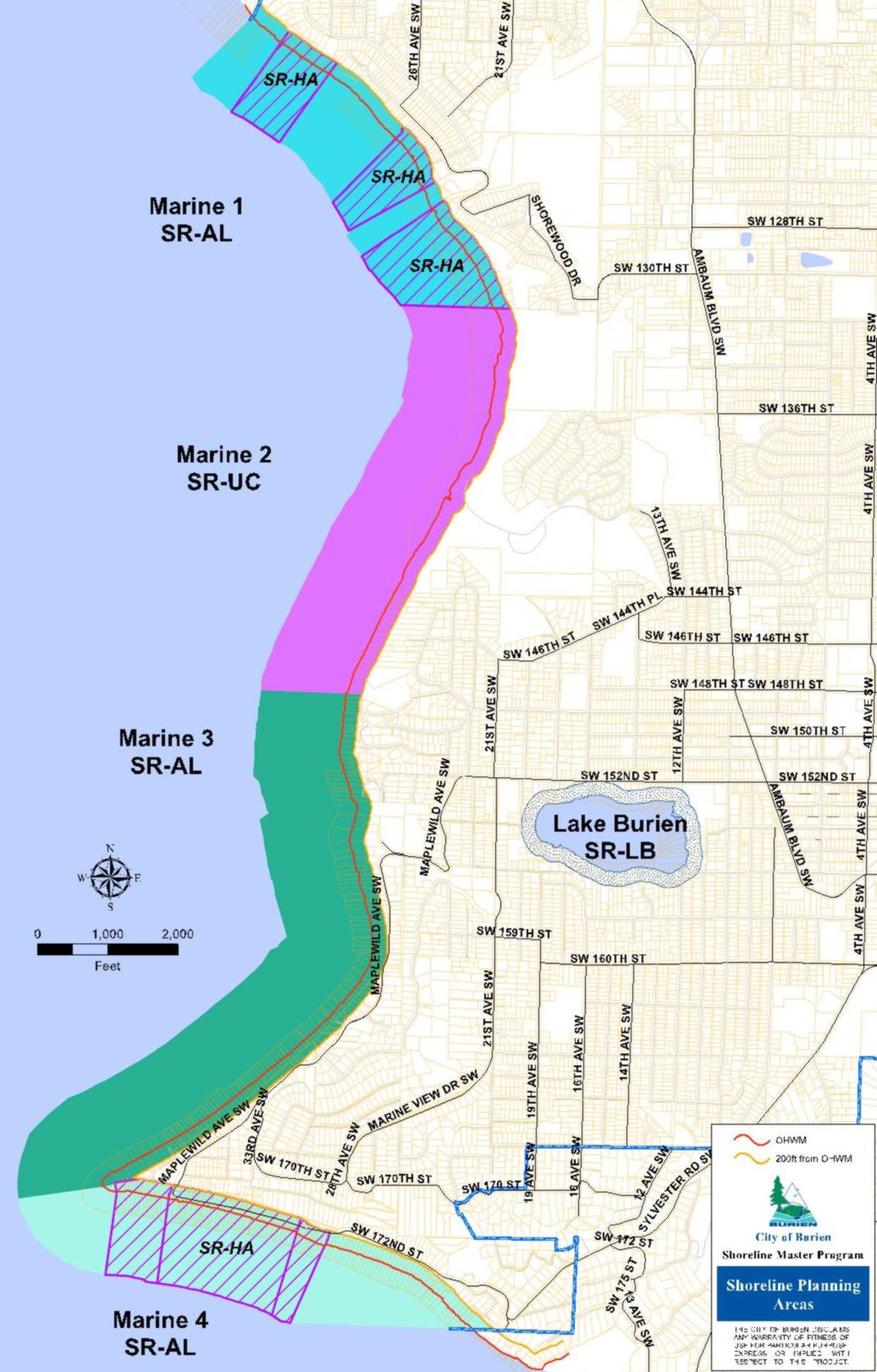
[Ord. 640 § 1 (Exh. A), 2016; Ord. 581 § 1 (Exh. A), 2013]
20.30.055 Shoreline buffers.
(1) Policy. While buffer widths based on science are necessary to protect ecological functions, it presents challenges in existing heavily developed areas such as along some parts of Burien. In such areas, an alternative strategy is established using smaller buffers that are based on existing development pattern, in combination with mitigation requirements for new development that provide enhancement of the smaller buffer and other degraded features to address impacts of the new development outside the small buffer areas when part of a vegetation conservation plan.
(2) Regulations.
(a) A shoreline buffer is established for the marine shoreline and for Lake Burien. This buffer consists of two zones: zone 1 and zone 2.
(i) Zone 1 is adjacent to the ordinary high water mark (OHWM). New development that would introduce adverse impacts is strictly limited within zone 1 and, if allowed, must be mitigated to assure no net loss.
(ii) Zone 2 is adjacent to the landward side of zone 1. New development in zone 2 that would introduce adverse impacts, if allowed, must be mitigated to assure no net loss, preferentially by restoration activities in zone 1.
(iii) The size of these zones varies as shown in BMC 20.30.050, Figure 5. Distances are measured on a horizontal plane in a direction that is perpendicular to the line of the OHWM.
(b) No Net Loss Compliance. All development within the buffer as set forth in BMC 20.30.050 and this section shall demonstrate that unavoidable adverse impacts are mitigated to achieve no net loss.
(i) Achieving no net loss can be achieved by:
(A) Avoiding an adverse impact; or
(B) Relocating the adverse impact to be outside the buffer; or
(C) By mitigating the impact.
(ii) Demonstrating that the development will comply with the no net loss standard can be accomplished by one of the following methods:
(A) An applicant submitting an ecological impacts report prepared by a qualified professional; or
(B) Completion of a project worksheet as set forth in subsection (2)(e) of this section. The shoreline administrator shall verify the accuracy of the completed worksheet in conjunction with the appropriate shoreline approval process.
(iii) The shoreline administrator may prepare standards and guidelines on what shall be included in an ecological impacts report to satisfactorily demonstrate compliance with the standards.
(c) Development Standards for Zone 1.
(i) New development in zone 1 shall be primarily for the following:
(A) Maintenance of existing structures; or
(B) Restoration or remodeling of existing structures within the existing footprint; or
(C) Voluntary restoration activities; or
(D) Providing required mitigation for adverse impacts in zone 2.
(ii) An access path from zone 2 to the line of the OHWM may be allowed as an exception.
(A) An access path shall be the minimum size and designed to serve this purpose.
(B) Additional flexibility may be allowed when it is necessary to meet the needs of users with limited mobility.
(C) When feasible, access paths shall be constructed using pervious materials.
(d) Development Standards for Zone 2.
(i) New development in zone 2 shall be primarily for the following:
(A) Maintenance of existing structures; or
(B) The restoration or remodeling of existing structures within the existing footprint; or
(C) Voluntary restoration activities.
(ii) New developments that result in adverse impacts may occur in buffer zone 2, if those impacts are mitigated and the total development activity achieves no net loss. New detached accessory structures are not allowed in buffer zone 2.
(iii) New single-family homes and expansion of existing single-family homes may be allowed in buffer zone 2 through the application of the common setback provisions of BMC 20.30.095(2)(c). New and expansions of existing single-family homes around Lake Burien are not allowed in buffer zone 2.
(e) Optional Method – Demonstrating Successful Mitigation of Unavoidable Adverse Impacts. An optional prescriptive worksheet (Figure 7) may be used in lieu of an ecological impact report. This method provides a means to quantify a measurement of certain adverse impacts and the benefits of certain improvements.
(i) Adverse Impacts. The scope of adverse impacts that can be evaluated are limited to the following:
(A) Creation or expansion of impervious surfaces; and
(B) Removal of existing native vegetation.
(ii) Ecological Benefits. Improvements to ecological functions are as follows:
(A) Removal or reduction of impervious surface; and
(B) Introduction or expansion of native vegetation.
(iii) The optional worksheet review process may only be applied in the evaluation of single-family residential development proposals.
(f) Over-water structures are allowed within the buffer as provided herein. Structures and development such as viewing platforms, boardwalks, benches, and trails are allowed when associated with public access. Pursuant to BMC 20.30.095(2)(g) (Accessory Structures and Appurtenances) fences less than six feet high, stairs and trams may be allowed within the buffer.
(g) Whenever the shoreline administrator determines that monitoring has established a significant adverse deviation from predicted impacts, or that mitigation or maintenance measures have failed, the applicant or the property owner shall be required to institute corrective action(s), which shall also be subject to further monitoring as provided in this section.
(h) The shoreline administrator may require a performance bond(s) or other security in an amount sufficient to guarantee that all required mitigation measures will be completed in a manner that complies with conditions of approval and to guarantee satisfactory workmanship and materials for a period not to exceed five years. The shoreline administrator shall establish the conditions of the bond or other security according to the nature of the proposed mitigation, maintenance or monitoring and the likelihood and expense of correcting mitigation or maintenance failures.
(i) All costs associated with the mitigation/monitoring and planning, including city expenses, shall be the responsibility of the applicant.
|
Measure of adverse impacts in zone 2 |
|
|
1) Total square feet of new impervious surface |
______ X 4 points = ______ |
|
2) Total square feet of cleared native vegetation |
______ X 2 points = ______ |
|
3) Total measurement (add 1 and 2) |
______ |
|
|
|
|
Benefit of adding native vegetation in zone 1 |
|
|
4) Total square feet of impervious surface eliminated |
______ X 4 points = ______ |
|
5) Total square feet of partially functioning area improved |
______ X 2 points = ______ |
|
6) Benefit of improvements in zone 1 (add 4 and 5) |
______ |
|
|
|
|
Benefit of improvements in zone 2 |
|
|
7) Square feet of impervious surface to native vegetation |
______ X 2 points = ______ |
|
8) Square feet of partially functioning area to native vegetation |
______ X 1 point = ______ |
|
9) Square feet of impervious surface to partially functioning area |
______ X 0.5 points = ______ |
|
10) Benefit of improvements in zone 2 (add 7 – 9) |
______ |
|
|
|
|
No Net Loss Indicator |
|
|
11) Measurement of adverse impacts (line 3) |
______ |
|
12) Total benefit of improvements (add 6 and 10) |
______ |
|
|
|
|
The project will meet the no net loss standard if line 11, the measurement of adverse impacts, is less than or equal to line 12, the benefit of improvements. |
|
[Ord. 581 § 1 (Exh. A), 2013]
20.30.060 Select shoreline uses and modifications.
Shoreline master programs establish a comprehensive program of use regulations for shorelines and provisions for specific uses to assure consistency with the policy of the act and where relevant within the jurisdiction. This section provides specific policies and regulations for the following types of uses and modifications:
(1) Aquaculture.
(2) Bulkheads and other shoreline stabilization structures.
(3) Docks, piers and floats.
(4) Habitat restoration and enhancement.
(5) Recreation.
(6) Recreational mooring buoys.
(7) Residential.
(8) Transportation facilities and parking.
(9) Utilities. [Ord. 581 § 1 (Exh. A), 2013]
20.30.065 Aquaculture.
Aquaculture means the culture, harvesting or farming of food fish, shellfish, or other aquatic plants and animals. Aquaculture does not include the harvest of wild geoduck associated with the state managed wildstock geoduck fishery. Sport fishing is not considered an aquaculture activity. Aquaculture activities include the hatching, cultivating, planting, feeding, raising, harvesting, and processing of aquatic plants and animals and the maintenance and construction of necessary equipment, buildings and growing areas. Cultivation methods include but are not limited to fish pens, fish hatcheries, shellfish rafts, racks and long lines, seaweed floats and nets and the culture of clams and oysters on tidelands and subtidal areas.
(1) Policies.
(a) Aquaculture should not be permitted in areas where it would result in a net loss of ecological functions, adversely impact eelgrass and macroalgae, or significantly conflict with existing adjacent uses.
(b) Aquacultural facilities must be designed and located so as not to spread disease to native aquatic life, establish new nonnative species which cause significant ecological impacts, or significantly impact the aesthetic qualities of the shoreline.
(2) Regulations.
(a) Aquaculture shall be limited to the recovery of a native aquatic population in accordance with a government and/or tribal approved plan.
(b) Aquaculture is not permitted in areas where it would result in a net loss of ecological functions, adversely impact eelgrass and macroalgae, or significantly conflict with navigation and other water-dependent uses.
(c) Aquaculture is prohibited in critical saltwater habitat or within a 10-foot buffer from these areas.
(d) No aquatic organism shall be introduced into city of Burien shoreline areas without the prior written approval of the Washington State Department of Fish and Wildlife or the appropriate regulatory agency for the specific organism.
(e) No aquacultural processing, except for the sorting or culling of the cultured organism and the washing or removal of surface materials or organisms, shall be permitted waterward of the ordinary high water mark unless fully contained within a tending boat or barge.
(f) Shellfish seeding and culturing is allowed when conducted for native population recovery in accordance with a government and/or tribal approved plan. [Ord. 706 § 1 (Exh. A), 2019; Ord. 581 § 1 (Exh. A), 2013]
20.30.070 Bulkheads and other shoreline stabilization structures.
Shoreline stabilization includes actions taken to address erosion impacts to property and dwellings, roads and utilities, businesses, or structures caused by natural processes, such as current, flood, tides, wind, or wave action. These actions include structural and nonstructural methods.
Nonstructural methods include building setbacks, relocation of the structure to be protected, ground water management, planning and regulatory measures to avoid the need for structural stabilization.
(1) Policies.
(a) New development should be located and designed to avoid the need for future shoreline stabilization to the greatest extent feasible.
(b) New and replacement bulkheads should be designed to blend in with the natural surroundings and not detract from the aesthetic qualities or degrade the natural processes of the shoreline.
(c) Burien should take active measures to preserve natural unaltered shorelines, and prevent the proliferation of new bulkheads and other forms of shoreline armoring.
(d) Nonstructural stabilization measures including relocating structures, increasing buffers, enhancing vegetation, managing drainage and runoff and other measures are preferred over new structural shoreline armoring.
(e) Where feasible, any failing, harmful, unnecessary, or ineffective structural shoreline armoring that cannot be repaired or replaced should be removed, and shoreline ecological functions and processes should be restored using nonstructural methods.
(For additional policy guidance, please see BMC 20.20.025 through 20.20.035.)
(2) Regulations.
(a) A shoreline stabilization structure legally existing on October 17, 2013:
(i) May be repaired and maintained.
(ii) May be replaced with a similar structure if the following apply:
(A) There is a demonstrated need to protect legally established principal uses or structures and legally established appurtenances necessary for use and enjoyment of a single-family home, which appurtenances shall not include fences, from erosion caused by currents, tidal action, or waves.
(B) The existing structure can no longer adequately serve its purpose of stabilizing the shoreline to protect established uses and structures.
(C) Replacement walls or bulkheads shall not encroach waterward of the ordinary high water mark or existing structure unless the residence was occupied prior to January 1, 1992, and there are overriding safety or environmental concerns. In such cases, the replacement structure shall abut the existing shoreline stabilization structure.
(D) Where a net loss of ecological functions associated with critical saltwater habitats would occur by leaving the existing structure, removal of that structure may be required as part of the construction of the replacement.
(E) Soft shoreline stabilization measures that provide restoration of shoreline ecological functions may be permitted waterward of the ordinary high water mark.
(b) Jetties, breakwaters and other in-water stabilization structures except for bulkheads are prohibited except for protection or restoration of ecological functions. New bulkheads and other shoreline stabilization structures such as gabions, revetments, retaining walls and bluff walls are allowed if there would be no net loss of shoreline ecological functions and the following requirements are met:
(i) Nonstructural methods (e.g., building setbacks, biotechnical vegetation measures, anchor trees, upland drainage control, and beach enhancement) are not feasible to protect a residence or other primary structure or essential public facility.
(ii) The necessity to protect existing primary structures is demonstrated in the following manner:
(A) A geotechnical analysis, accepted by the administrator, confirming that there is a significant possibility that the primary structure will be damaged within three years as a result of shoreline erosion caused by tidal action, currents, or waves in the absence of an armoring structural solution. Normal sloughing, erosion of steep bluffs, or shoreline erosion itself, without a scientific or geotechnical analysis, is not demonstration of need.
(B) The geotechnical analysis should evaluate on-site drainage issues and address drainage problems away from the shoreline edge before considering structural shoreline stabilization.
(c) The following requirements apply to both new and replacement bulkheads:
(i) Bulkheads shall be located and constructed in a manner which will not result in adverse effects on littoral drift and adjacent properties.
(ii) Bulkheads shall not be installed solely for the purpose of creating upland by filling behind the bulkhead.
(iii) The size and quantity of material utilized for the bulkhead shall be the minimum necessary to protect the structure from the estimated energy intensity of the shoreline hydraulic system.
(iv) The maximum height of a new bulkhead on the marine shoreline shall be no greater than four vertical feet above the OHWM. The height of a replacement bulkhead shall not exceed four vertical feet above the OHWM or exceed the height of the existing bulkhead, whichever is greater.
(d) All new and replacement shoreline structures shall be designed to minimize the transmission of wave energy.
(e) All new shoreline development and uses, including the replacement of a destroyed home, shall be located and designed to prevent the need for new or expanded shoreline stabilization measures for the life of the development. Exceptions may be made for the limited instances where shoreline stabilization measures are necessary to protect allowed uses, where no alternative locations are available, and where no net loss of ecological functions will result. [Ord. 581 § 1 (Exh. A), 2013]
20.30.075 Over-water structures – Including docks, piers and floats.
Docks are fixed structures floating upon the water. Piers are fixed, pile-supported structures. Floats (rafts) are floating structures that are moored, anchored, or otherwise secured in the water that are not directly connected to the shoreline. All of these types of over-water structures are found in the city’s shoreline jurisdiction. These structures typically require permits from local, state and federal agencies. For structures overlying state owned lands, an aquatic lands lease and authorization from the Department of Natural Resources is required. For the purposes of this section, docks, piers, and floats will be called over-water structures and addressed together unless otherwise noted. In addition to the following policies and regulations, applicants for an over-water structure should contact other permitting agencies including the Washington State Department of Fish and Wildlife and U.S. Army Corps of Engineers for their requirements, including dimensional standards.
(1) Policies.
(a) Over-water structures should be designed to minimize impacts to ecological functions of the water body including but not limited to water quality, anadromous and forage fish habitat, spawning and rearing areas, migration, and passage.
(b) New over-water structures should be restricted to the minimum size necessary and permitted only when the applicant has demonstrated that a specific need exists to support the intended water-dependent use.
(c) Ensure that over-water structures are designed and maintained to avoid adverse impacts to the environment and shoreline aesthetics and minimize interference with the public’s use of the water and public beach area.
(d) Encourage the use of mooring buoys in place of over-water structures.
(e) Encourage shared docks between multiple owners for single-family waterfront development to minimize over-water coverage adversely impacting shoreline ecological functions.
(f) Over-water structures should be designed to avoid the need for maintenance dredging. The moorage of a boat larger than provided for in the original moorage design shall not be grounds for approval of dredging.
(2) Regulations.
(a) New over-water structures shall be limited to those required as part of a permitted water-dependent use, ecological restoration or public access.
(b) Over-water structure design and construction shall be restricted to the minimum necessary to meet the needs of the proposed water-dependent use.
(c) Private, single residence over-water structures for the sole use of the property owner shall not be considered an outright use on city of Burien marine shorelines. An over-water structure may be allowed on the marine shoreline when the applicant has demonstrated a need for moorage and the following alternatives have been investigated and are not available or feasible:
(i) Commercial or marina moorage;
(ii) Floating moorage buoys;
(iii) Joint use moorage pier.
(d) The design and construction of over-water structures, as well as their subsequent use and operation, shall:
(i) Be capable of withstanding expected environmental conditions; and
(ii) Minimize interference with adjacent water uses and navigation; and
(iii) Minimize adverse effects on fish, shellfish, wildlife, water quality, public views and geohydraulic processes by limiting the size of the structure and the use of hazardous materials, incorporating grating to allow light passage or reflective panels to increase light refraction, and spaced and oriented to minimize shading and avoid a “wall” effect that would block or baffle wave patterns, currents, littoral drive, or movement of aquatic life forms.
(e) Over-water structures shall not be used for residential dwelling purposes nor provide moorage for boats that are occupied longer than two days unless pump-out facilities are available and then no longer than seven days total.
(f) Only joint use over-water structures are allowed for attached dwelling unit developments.
(g) Only one over-water structure is allowed for each single-family detached residential lot.
(h) No covered moorage is allowed waterward of the ordinary high water mark.
(i) When permitted, new residential development of two or more dwellings shall provide joint use or community docks, rather than individual docks, when feasible, rather than allow individual docks for each residence.
(j) Dredging associated with over-water structures is prohibited in the aquatic environment. [Ord. 581 § 1 (Exh. A), 2013]
20.30.080 Habitat restoration and enhancement.
Shoreline habitat and natural systems enhancement projects include those activities proposed and conducted specifically for the purpose of establishing, restoring, or enhancing habitat for priority species in shorelines. Restoration or enhancement of shoreline areas means a change of the physical, chemical, or biological characteristics of a site with the goal of returning natural or historic ecological functions of a former or degraded wetland or fish and wildlife habitat conservation area.
(1) Policy.
(a) Habitat restoration or enhancement projects that are not exempt pursuant to WAC 173-27-040 (Developments exempt from substantial development permit requirement) may be allowed in shoreline jurisdiction if a shoreline substantial development permit is obtained.
(For additional policy guidance, please see BMC 20.20.050.)
(2) Regulations.
(a) Shoreline restoration or enhancement shall be designed to result in a natural shoreline with functions, vegetative communities and structure similar to what would historically have been found on the site or in the vicinity.
(b) All shoreline restoration or enhancement projects shall ensure that critical areas and their functions are not degraded by the action.
(c) Shoreline restoration projects shall implement the city’s adopted shoreline restoration plan and be conducted specifically for the purpose of establishing, restoring, or enhancing habitat for priority species in shorelines.
(d) Nonstructural approaches for shoreline restoration or enhancement shall be used for shoreline stabilization instead of bulkheads or other structural stabilization measures, where feasible.
(e) Shoreline restoration projects that are not specifically listed in the city’s adopted shoreline restoration plan shall be considered subject to approval of the shoreline administrator.
(f) Existing artificial structures on the site of a shoreline restoration or enhancement project that appear to be impeding natural recovery of a species or habitat shall be removed.
(g) When habitat is restored or enhanced, priority shall be given to retention of snags and trees that provide overhanging vegetation and/or nesting or perching branches for eagles, other raptors, or priority species.
(h) Shoreline habitat restoration or enhancement projects shall not adversely impact sediment processes, littoral drift, wetlands or fish and wildlife habitat conservation areas.
(i) Beach enhancement shall not be allowed within spawning, nesting or breeding habitats unless the completed project will result in a greater long-term benefit to the ecological functions and values.
(j) Restoration of native vegetation shall comply with the vegetation conservation section, BMC 20.30.040. In addition to the provisions of BMC 20.30.040, a revegetation plan shall include a monitoring and maintenance program that shall, at a minimum, include the following:
(i) Goals and objectives for the mitigation plan; and
(ii) Criteria for assessing the effectiveness of the mitigation; and
(iii) Monitoring plan including annual progress reports submitted to the shoreline administrator. The plan shall be in effect for a period of time sufficient to establish that performance standards have been met as determined by the shoreline administrator, but no less than five years; and
(iv) A contingency/adaptive management plan.
(k) Restoration resulting in movement of the OHWM shall meet the following standards:
(i) The shoreline administrator may grant relief from shoreline master program development standards and use regulations when the following apply:
(A) A shoreline restoration project causes or would cause a landward shift in the ordinary high water mark, resulting in the following:
1. a. Land that had not been regulated under this shoreline master program prior to construction of the restoration project is brought under shoreline jurisdiction; or
b. Additional regulatory requirements apply due to a landward shift in required shoreline buffers or other regulations of the shoreline master program; and
2. Application of shoreline master program regulations would preclude or interfere with use of the property permitted by other development regulations, thus presenting a hardship to the project proponent;
(B) The proposed relief meets the following criteria:
1. The proposed relief is the minimum necessary to relieve the hardship;
2. After granting the proposed relief, there is net environmental benefit from the restoration project;
3. Granting the proposed relief is consistent with the objectives of the shoreline restoration project and consistent with the shoreline master program; and
4. Where a shoreline restoration project is created as mitigation to obtain a development permit, the project proponent required to perform the mitigation is not eligible for relief under this section; and
(C) The application for relief must be submitted to the Department of Ecology for written approval or disapproval. This review must occur during the Department of Ecology’s normal review of a shoreline substantial development permit, conditional use permit, or variance. If no such permit is required, then the Department of Ecology shall conduct its review when the city of Burien provides a copy of a complete application and all supporting information necessary to conduct the review.
1. Except as otherwise provided in subsection (2)(k)(ii) of this section, the Department of Ecology shall provide at least 20 days’ notice to parties that have indicated interest to the Department in reviewing applications for relief under this section, and post the notice on their website.
2. The Department shall act within 30 calendar days of close of the public notice period, or within 30 days of receipt of the proposal from the local government if additional public notice is not required.
(ii) The public notice requirements of subsection (2)(k)(i)(c) of this section do not apply if the relevant shoreline restoration project was included in a shoreline master program or shoreline restoration plan as defined in WAC 173-26-201 (Comprehensive process to prepare or amend shoreline master programs), as follows:
(A) The restoration plan has been approved by the Department of Ecology under applicable shoreline master program guidelines;
(B) The shoreline restoration project is specifically identified in the shoreline master program or restoration plan or is located along a shoreline reach identified in the shoreline master program or restoration plan as appropriate for granting relief from shoreline regulations; and
(C) The shoreline master program or restoration plan includes policies addressing the nature of the relief and why, when, and how it would be applied.
(iii) A substantial development permit is not required on land that is brought under shoreline jurisdiction due to a shoreline restoration project creating a landward shift in the ordinary high water mark. [Ord. 581 § 1 (Exh. A), 2013]
20.30.085 Recreational development.
Shoreline recreational development includes facilities for activities such as hiking, fishing, picnicking, swimming, photography and viewing. It also includes facilities for more intensive uses, such as parks. This section applies to both publicly and privately owned shoreline facilities intended for use by the public or private group, association, or individual.
(1) Policies.
(a) Allow a variety of active and passive recreation opportunities in the shoreline areas.
(b) Encourage provision of view points, rest areas and picnic facilities in public shoreline areas.
(For additional policy guidance, including policies that provide for public access planning as set forth in WAC 173-26-221(4)(c) (General master program provisions, Planning process to address public access), please see BMC 20.20.020.)
(2) Regulations.
(a) Commercial recreational development or use in Seahurst Park shall be consistent with the provisions of this section.
(b) Recreation facilities shall be designed to take maximum advantage of and enhance the natural character of the shoreline area.
(c) Recreation areas shall promote public health, safety and security and not materially interfere with the normal public use of the water and shorelines.
(d) Recreation facilities shall provide adequate provisions to prevent the general public from trespassing and overflowing into adjacent, privately owned properties.
(e) Recreation facilities shall provide signage that prohibits tree cutting and collecting of marine life, driftwood and other natural materials.
(f) Jet skis and water craft with combustion engines are prohibited on Lake Burien.
(g) No person shall moor, anchor or dock a boat or other object overnight on or within 50 feet of the ordinary high water mark at any city beachfront park without authorization from the city of Burien parks department.
(h) Shoreline recreational development is a priority and shall be primarily related to access to, enjoyment and use of the water and shorelines of the state. [Ord. 581 § 1 (Exh. A), 2013]
20.30.090 Recreational mooring buoys.
A recreational mooring buoy is a device used to tie up a boat and typically consists of a line from the boat attached to a float at the water’s surface with a cable or line fixed underwater to the submerged ground. The anchor line allows the boat to float and swing around the fixed buoy anchor.
(1) Policies.
(a) Recreational boat mooring buoys are the preferred method to provide moorage instead of constructing new residential docks, piers or floats on the marine waters in the city of Burien.
(For additional policy guidance, please see BMC 20.20.020.)
(2) Regulations.
(a) Mooring buoys shall be located as close to the shore as possible while avoiding beaching under all tidal situations and no farther waterward than existing authorized mooring buoys unless the drift of the boat dictates it.
(b) Mooring buoys shall be located away from critical saltwater habitat.
(c) Mooring buoys shall utilize a system design that minimizes damage to underwater lands and marine vegetation.
(d) Individuals owning residential property abutting aquatic lands may install a mooring buoy for recreational purposes after obtaining approval from the State of Washington Department of Natural Resources (DNR), Washington Department of Fish and Wildlife (WDFW) and the Army Corps of Engineers as appropriate.
(e) Recreational mooring buoys shall be installed using a DNR or WDFW approved system.
(f) Buoys shall be visible under normal daylight conditions at a minimum of 100 yards during daylight hours and must have reflectors for nighttime visibility.
(g) Recreational mooring buoys are prohibited for commercial and transient uses or live-aboards.
(h) Boats must be 60 feet or less in length to tie up to a recreational mooring buoy.
(i) A community beach may have one mooring buoy for every 100 lineal feet of waterfront.
(j) Mooring buoys are prohibited on Lake Burien. [Ord. 581 § 1 (Exh. A), 2013]
20.30.095 Residential development.
Single-family residences are the most common form of shoreline development and are identified as a priority use when developed in a manner consistent with control of pollution and prevention of damage to the natural environment. “Residential development” shall mean the creation of new residential lots and the construction or exterior alteration of one or more buildings, structures or portions thereof which are designed for and used to provide a place of abode for human beings including one- and two-family detached dwellings, multifamily residences, townhouses and condominiums, together with appurtenances and accessory structures. For purposes of this master program, bed and breakfast establishments are considered an accessory use (see also BMC 20.30.001, Figure 4, Shoreline Permit Matrix, under Commercial Use and Development).
(1) Policy. Residential development should demonstrate that the development and its related activities will not be detrimental to the public interest and uses of the shoreline and its associated water bodies.
(For additional policy guidance, please see BMC 20.20.025 through 20.20.035.)
(2) Regulations.
(a) General. Consistent with WAC 173-26-221(4)(d)(iv) (General master program provisions, Standards for height limits, setbacks, and view corridors), residential development shall protect existing shoreline and water views, promote public safety, avoid adverse impacts to marine bluffs and nearshore habitat, and not result in a net loss of shoreline ecological functions.
(b) Dimensional Standards. Residential development in shoreline jurisdiction shall conform to the dimensional standards found in BMC 20.30.050.
(c) Common-Line Building Setback Standards. The shoreline administrator may approve new or expanded single-family primary residential structures in zone 2 of the shoreline buffer under the following conditions through the conditional use permit process and without a variance permit:
(i) Where there are existing legally constructed single-family primary residential structures that are located within the shoreline buffer zone 2 designated in BMC 20.30.050 and within 50 feet of either side of the proposed building site, a new or expanded home may be located in the shoreline buffer. As an alternative in such cases, the proposed new or expanded single-family primary residential structure may be set back from the OHWM common to the average of the OHWM setback of the existing adjacent residences (see Figure 8).
(ii) In those instances where only one existing single-family primary residence is within 50 feet of the proposed building site, the OHWM setback of the proposed structure may be reduced to the average of the OHWM setbacks for the existing adjacent residence and the applicable setback for the adjacent vacant parcel.
(iii) In no case shall the reduced setback allow development in zone 1 without a variance.
(iv) In cases where the common-line setback does not apply, expansion of existing single-family primary residential structures within the designated shoreline buffer zone 2 may be allowed through a conditional use permit.
(v) Any shoreline OHWM setback reduction beyond that allowed in this section shall require approval of a shoreline variance permit.
(vi) For the purposes of this section the optional method of demonstrating successful mitigation of unavoidable adverse impacts as set forth in BMC 20.30.055(2)(e) may not be used and the applicant shall submit an ecological impact report prepared by a qualified professional demonstrating that unavoidable impacts are mitigated to achieve no net loss.
(d) Lot Size Calculations. Lot size calculations shall not include portions of the lot that are waterward of the ordinary high water mark.
(e) Bluff Top Protection. New development located at the top of bluffs in shoreline jurisdiction must be set back to ensure that shoreline stabilization is unlikely to be necessary for the life of the structure as demonstrated by a geotechnical analysis.
(f) Vegetation Removal for Access. Private access from single-family detached residences to the shoreline shall avoid removal of trees and other woody vegetation when feasible.
(g) Accessory Structures and Appurtenances. New accessory structures and appurtenances must be proportional in size and purpose to the residence and compatible with on-site and adjacent structures, uses and natural features. New accessory structures and appurtenances are not permitted within the shoreline buffer zone 1 unless otherwise permitted by subsection (2)(c) of this section (Common-Line Building Setback Standards). New detached accessory structures are not allowed in buffer zone 2. The following may be allowed in the shoreline buffer:
(i) Fences less than six feet high;
(ii) Water-dependent features (buoys, docks and floats) used for recreational or personal use;
(iii) Stairs and trams pursuant to subsections (2)(i) and (j) of this section;
(iv) Utilities solely serving the subject single-family residence.
(h) Floating Homes or Houseboats. Floating homes or houseboats are prohibited in shoreline jurisdiction.
(i) Stairs and Trams. Construction of new stairs and trams to the beach is allowed within required shoreline buffer areas, except on feeder bluffs, provided the project proponent demonstrates that existing shared, public or community facilities are not adequate or available for use and the possibility of a multiple-owner or multiple-user facility has been thoroughly investigated and is not feasible. New facilities are encouraged to be shared with adjacent properties that do not already have such facilities, and shall include shared maintenance easements and agreements as necessary. Only one stair or tram system is allowed for each primary residential structure; duplicate facilities are not allowed.
(j) Beach Stairs and Trams Design. New beach stairs and trams shall be designed and located such that no fill or other modification waterward of the ordinary high water mark is necessary to construct or use the structure. Stairways, trams and landings shall be located upland of existing bulkheads.
(k) Detached Accessory Dwelling Units. New detached accessory dwelling units shall not be located in the shoreline buffers.
Figure 8: Common-Line Buffer and OHWM Building Setback Reduction Examples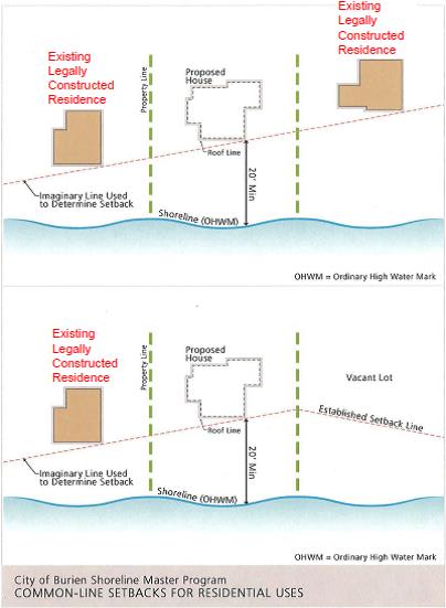
[Ord. 581 § 1 (Exh. A), 2013]
20.30.100 Transportation facilities and parking.
Transportation facilities are those structures and developments that aid in land and water surface movement of people, animals, goods and services. They include streets, bridges, bikeways, trails and other related facilities.
(1) Policies.
(a) All new or expanded roadways should be designed and located to minimize impacts to shoreline ecological functions including riparian and nearshore areas, and the natural landscape.
(b) Parking is not a preferred use in shorelines and should only be allowed to support authorized uses where no feasible alternatives exist.
(For additional policy guidance, please see BMC 20.20.025.)
(2) Regulations.
(a) New transportation and parking facilities shall be located outside of the shoreline jurisdiction or as far landward from the ordinary high water mark as feasible, unless they support public access or other authorized use.
(b) Transportation facilities shall be designed and maintained to minimize erosion, preserve natural drainage ways and utilize low-impact development techniques.
(c) Transportation and utility facilities shall share rights-of-way to minimize disturbance in shoreline areas.
(d) The city shall give preference to mechanical means rather than the use of herbicides for roadside brush control on city streets in shoreline areas.
(e) Construction debris, overburden and other waste materials shall not be allowed to enter into any water body by disposal or erosion from drainage, high water or other means.
(f) Transportation facilities shall provide public access appropriate to the location and extent of the facility.
(g) All shoreline areas disturbed by road construction and maintenance shall be replanted and stabilized. Such vegetation shall be maintained by the agency or developer constructing or maintaining the road until established.
(h) Landscaping shall be provided to minimize visual impacts for all new and expanded transportation facilities in shoreline areas. A landscape plan shall be provided in conjunction with review and issuance of a shoreline substantial development permit. [Ord. 581 § 1 (Exh. A), 2013]
20.30.105 Utilities.
Utilities are services and facilities that produce, convey, transmit, store, or process water, sewage, communications, electric power, fuel, natural gas, and the like.
(1) Policies.
(a) On-site utility features serving a primary use, such as water, sewer or gas lines to a residence, are considered a part of the primary use.
(b) Utilities production and processing facilities, such as sewage treatment plants, or parts of those facilities that are non-water-oriented should not be allowed in shoreline areas unless it can be demonstrated that no other feasible option is available.
(c) Utilities should be located and designed to assure no net loss of shoreline ecological functions, preserve the natural landscape, and minimize conflicts with present and planned land and shoreline uses while meeting the needs of future populations in areas planned to accommodate growth.
(d) New development of pipelines and cables on tidelands, particularly those running roughly parallel to the shoreline, and development of facilities that may require periodic maintenance which would disrupt shoreline ecological functions should be discouraged except where no other feasible alternative exists.
(For additional policy guidance, please see BMC 20.20.020 and 20.20.030.)
(2) Regulations.
(a) Utilities shall be placed underground pursuant to Chapter 12.40 BMC (Utility Undergrounding Policy).
(b) New development of underwater pipelines and cables on tidelands is prohibited except for deepwater outfalls and facilities where no other feasible alternative exists.
(c) New cable crossings for telecommunications and power lines entering or leaving a body of water shall be bored or buried below the surface of the water body’s bed from the ordinary high water mark out to a minimum water depth of minus 10 feet below mean lower low water.
(d) Directional boring, instead of excavation or trenching, is required where feasible.
(e) New transmission facilities for the conveyance of services, such as power lines, cables, and pipelines, shall be located outside of the shoreline area where feasible and when necessarily located within the shoreline area shall assure no net loss of shoreline ecological functions. When allowed, utility and transportation facilities shall share rights-of-way to minimize disturbance in shoreline areas.
(f) New or altered aerial utility lines and vertical utility facilities shall make maximum use of topography to minimize visual impact on the surrounding area.
(g) Communication, radio towers and personal wireless service facilities shall not obstruct or destroy scenic views of the water. This may be accomplished by design, orientation and location of the tower, height, camouflage of the tower, or other features consistent with utility technology.
(h) Culverts shall be located and installed in accordance with city of Burien standards and specifications.
(i) New and replacement sanitary sewage systems shall be designed to minimize or eliminate infiltration of flood waters into the systems and discharge from the systems into flood waters.
(j) Except for water lines, all underwater pipelines transporting substances hazardous to aquatic life or water quality are prohibited unless no other feasible alternative exists. Such facilities shall include an automatic shut off valve on both shorelines and have established maintenance procedures.
(k) Expansion or repair of existing, underground utilities within shoreline jurisdiction shall include reclamation of areas disturbed during construction including, where feasible, replanting and maintenance care until the newly planted vegetation is established. [Ord. 581 § 1 (Exh. A), 2013]