


Chapter 18.71
MILITARY TRAINING ROUTE OVERLAY
Sections:
18.71.030 Land use regulations.
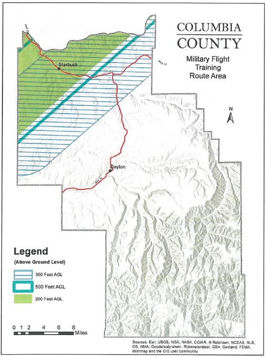
18.71.050 Military flight training route map.
18.71.010 Purpose.
The regulations of this chapter shall be applied to protect the public safety of persons residing under military training routes (MTRs) by requiring that all new development is compatible with military operations within the MTRs. The MTRs are comprised of a three dimensional airspace designated for military training and transport activities that have a defined floor (minimum altitude) and ceiling (maximum altitude). The MTR boundaries and minimum altitudes are identified in the Military Flight Training Route Area Map (CCC 18.71.050). Within the MTR, the county shall consider the impact of new development on military readiness activities and provide notice to the military of new discretionary development within MTRs. [Ord. 2019-06 § 2 (Exh. B).]
18.71.020 Applicability.
The regulations set out in this chapter shall apply in all areas where a MTR is designated in addition to the regulations specified in this title. If any of the regulations specified in this chapter differ from any corresponding regulations specified in this title for any base zone, then in such case the provisions of this chapter shall apply. [Ord. 2019-06 § 2 (Exh. B).]
18.71.030 Land use regulations.
A. The MTR overlay is established to regulate new development to ensure that it is compatible with military operations. Within the MTR overlay, all new development that could penetrate the defined floor elevation shall require issuance of an administrative permit or use permit. If the use is already subject to an administrative permit or use permit no additional administrative permit is required. No permit shall be approved for any use in any zone which is subject to the MTR overlay until an investigation is conducted by the planning director who shall review the proposed project for hazards to aircraft and military operations including but not limited to:
1. Uses that physically obstruct any portion of the MTR due to relative height above ground level.
B. For the purposes of determining whether a project penetrated the defined floor elevation of the MTR, a “penetration” shall mean physical obstructions from a structure or object.
C. For the purposes of calculating height of new proposed structures within the MTR, the height of all structures (including wind turbines) shall mean the distance from ground to the top of the highest point of the structure. For wind turbines this shall mean the highest point of the turbine blade in vertical position.
D. Projects that could penetrate the defined floor elevation shown in the county’s military overlay zone map, including but not limited to wind energy system permit applications, shall require notices with the project description, including location and height, be mailed or delivered to the military expert for the Northwest Training Range Complex who is responsible for operations within the military training route (CCC 18.71.050) upon receipt of the application to the planning department for review. [Ord. 2019-06 § 2 (Exh. B).]
18.71.040 Special provisions.
Special provisions for the MTR overlay district shall be as follows:
A. Within the military review areas depicted in CCC 18.71.050, any structure or land use that is determined to physically or visually obstruct any portion of the applicable MTR shall not be permitted, established or otherwise constructed unless an administrative permit or use permit is granted subject to a finding that the proposed structure or land use will not impact military operations within the MTR as follows:
1. Proposed structures and uses with impacts contained under the floor elevation of the applicable MTR shall be permitted with the issuance of an administrative permit or use permit upon finding that:
a. The proposed structure and use does not penetrate the floor elevation of the MTR;
b. That the project is not detrimental to the function of the MTR and would not pose a health or safety hazard to the public and/or military personnel; and
c. That the proposed structure and use is consistent with all other applicable provisions of this chapter.
B. Proposed structures and uses with impacts that penetrate the floor elevation of the applicable MTR as determined by the planning director during review of the administrative permit may only be permitted with the issuance of a use permit as follows:
1. Unless the military expert responsible for operations in the military training areas first provides the planning director with written concurrence that the height of the proposed structure or use would be compatible with military operations and mission, and notwithstanding any other provisions in this title, no use permit may be issued for any structure that is above the floor elevations shown in CCC 18.71.050.
2. In instances where the required written concurrence from the military expert is requested but not received within 30 calendar days, the use permit may be considered and approved by the planning commission.
3. Approval of a use permit for structures above the floor elevations shown in CCC 18.71.050 may be approved by the planning commission upon a finding that the benefits of the requested obstruction into the MTRs outweigh the potential impacts on military flight operations.
4. That the proposed structure and use is consistent with all other applicable provisions of this chapter.
C. Where a finding is made during the use permit review that the proposed structure and use penetrates the MTR floor elevation such that military operations within the MTR are impacted, and that the project is detrimental to the function of the MTR and would pose a health or safety hazard to the public and/or military personnel, the issuance of the use permit shall be denied. [Ord. 2019-06 § 2 (Exh. B).]
18.71.050 Military flight training route map.
[Ord. 2019-06 § 2 (Exh. B).]