


Division 2. Critical Areas Regulations
Chapter 17.10
CRITICAL AREAS
Sections:
Article I. Generally
17.10.130 Chapter applicability.
17.10.145 Public agency and utility exception.
17.10.150 Administrator appointed.
17.10.160 Abrogation and greater restrictions.
17.10.170 Reasonable use provision.
17.10.190 Critical areas study review.
Article II. Technical Study and Reporting
17.10.210 Reference maps and materials.
17.10.220 Critical areas review process.
Article III. Fish and Wildlife Habitat Conservation Areas
17.10.330 Classification and designation.
17.10.340 Critical area review process for fish and wildlife habitat conservation areas.
17.10.350 Performance standards.
Article IV. Wetlands
17.10.430 Critical areas review.
17.10.440 Classification – Wetland rating system.
17.10.460 Road/street construction.
17.10.490 Compensatory mitigation.
Article V. Critical Aquifer Recharge Areas
17.10.540 Critical areas process for critical aquifer recharge areas.
17.10.550 Performance standards – General requirements.
17.10.560 Performance standards – Specific uses.
17.10.570 Uses prohibited in critical aquifer recharge areas.
Article VI. Frequently Flooded Areas
17.10.620 Frequently flooded areas – Designation and classification.
17.10.630 Protection measures.
Article VII. Geologically Hazardous Areas
17.10.740 Critical area review process for geologically hazardous areas.
17.10.750 Performance standards.
Prior legislation: Ords. 596 and 659.
Article I. Generally
17.10.110 Purpose.
The purpose of this chapter is to identify and protect critical areas as required by Chapter 36.70A RCW and to protect people from hazards posed by critical areas, by supplementing the development requirements contained in the various chapters of the city code and providing for protection measures for critical areas. This chapter is adopted under the authority of RCW Title 35A, Chapter 36.70A RCW and the Entiat Municipal Code as now or hereafter amended.
In some areas, it may be important to use the critical areas regulations along with other regulations, such as stormwater management and flood damage prevention regulations, in order to adequately address risks to life, property, and the environment. (Ord. 829 § 1, 2021; Ord. 733 § 1 (Exh. A), 2012)
17.10.120 Definitions.
“Agency consultation” means consultation with the Washington Department of Fish and Wildlife and/or the U.S. Fish and Wildlife Service for the purpose of making a preliminary determination regarding impacts of a development proposal on fish and wildlife habitat conservation area functions and values. “Agency consultation” does not mean “Endangered Species Section 7 Consultation.”
“Alteration” means any human-induced action that changes the existing condition of a critical area. Alterations include, but are not limited to: grading; filling; dredging; draining; channelizing; discharging pollutants except stormwater; paving, construction, application of gravel; modifying for surface water management purposes; vegetation removal, or any other human activity that changes the existing landforms, vegetation, hydrology, wildlife or wildlife habitat of a critical area. For actions within wetlands, also see “Wetland alteration.”
“Appeal” means a request for a review of the city’s interpretation of any provision of this chapter or a request for a variance.
“Applicant” means the person, party, firm, corporation or other entity that proposes any use that could affect a critical area, as defined in this chapter.
“Aquifer” means a water-bearing stratum of permeable rock, sand or gravel.
“Aquifer recharge” means the movement or percolation (usually downward) of surface water through an unsaturated zone of soil or rock into a groundwater body.
“Aquifer recharge area” means an area with a recharging effect on aquifers used for potable water.
“Best management practices” or “BMPs” means schedules of activities, prohibitions of practices, maintenance of procedures, and other management practices, to prevent or reduce the pollution of other critical areas. BMPs also include treatment requirements, operating procedures and practices to control plant site runoff, spillage or leaks, sludge or water disposal, or drainage from raw material storage.
“Buffer” means an area adjacent to a critical area, retained to reduce impacts from adjacent land uses and protect and maintain critical area functions and values, and structural stability.
“Clearing” means the destruction and removal of vegetation by burning, mechanical or chemical methods.
“Contaminant” means any chemical, physical, biological, or radiological substance present in sufficient quantity that its accidental or intentional release would present a substantial risk to human health or the environment in the concentrations found at the point of compliance.
“Critical aquifer recharge areas” or “CARAs” are those areas with a critical recharging effect on aquifers used for potable water as defined by WAC 365-190-030(3).
“Critical areas” includes the following areas and ecosystems: wetlands; areas with a critical recharging effect on aquifers used for potable water; fish and wildlife habitat conservation areas; frequently flooded areas; and geologically hazardous areas.
“De minimus impact” means a small or minuscule impact that is demonstrated to be nonharmful to the environment.
“Development” includes building, expansion of existing buildings, clearing and grading, new agricultural planting, and land division.
“EMC” means Entiat Municipal Code.
“Erosion hazard areas” are those areas containing soils which, according to the United States Department of Agriculture Natural Resources Conservation Service Soil Survey Program, may experience significant erosion. Erosion hazard areas also include coastal erosion-prone areas and channel migration zones.
“Existing and ongoing agricultural activities” means those activities conducted on lands defined in RCW 84.34.020(2), and those activities involved in the production of crops and livestock, including but not limited to operation, maintenance and conservation measures of farm and stock ponds or drainage ditches, irrigation systems, changes between agricultural activities, and normal operation, maintenance or repair of existing serviceable structures, facilities or improved areas. Activities which bring an area into agricultural use are not part of an ongoing activity. An operation ceases to be ongoing when the area in which it was conducted is proposed for conversion to a nonagricultural use or has lain idle for a period of longer than five years, unless the idle land is registered in a federal or state soils conservation program. Forest practices are not included in this definition.
“Existing and ongoing forestry activities” means those activities conducted on lands defined in RCW 84.34.020(3) and occurring under regulation of the Forest Practices Act, on lands capable of supporting a merchantable stand of timber and not being actively used for a use which is incompatible with timber growing.
“Fill” or “fill material” means a deposit of material placed by human or mechanical means.
“Filling” means the act of placing (by any manner or mechanism) fill material from, to, or on any soil surface, sediment surface or other fill material.
“Fish and wildlife habitat conservation area” or “FWHCA” are areas that serve a critical role in sustaining needed habitats and species for the functional integrity of the ecosystem, and which, if altered, may reduce the likelihood that the species will persist over the long term. These areas may include, but are not limited to, rare or vulnerable ecological systems, communities, and habitats or habitat elements including seasonal ranges, breeding habitat, winter range, and movement corridors; and areas with high relative population density or species richness.
Fish and wildlife habitat conservation areas do not include such artificial features or constructs as irrigation delivery systems, irrigation infrastructure, irrigation canals, or drainage ditches that lie within the boundaries of, and are maintained by, a port district or an irrigation district or company, except where irrigation water is conveyed through a natural channel feature as part of its delivery.
“Frequently flooded areas” are lands in the floodplain subject to at least a one percent or greater chance of flooding in any given year, or within areas subject to flooding due to high groundwater. These areas include, but are not limited to, streams, rivers, lakes, coastal areas, wetlands, and areas where high groundwater forms ponds on the ground surface.
“Geologically hazardous areas” are areas that because of their susceptibility to erosion, sliding, earthquake, or other geological events, are not suited to siting commercial, residential, or industrial development consistent with public health or safety concerns.
“Geotechnical assessment” means an assessment prepared by a qualified professional for geologically hazardous areas, detailing the surface and subsurface conditions of a site and delineating the areas of a property subject to geologic hazards, and meeting the standards specified in this title.
“Geotechnical engineer” is a person with a Washington state license in civil engineering who has at least four years of professional employment as a geotechnical engineer with experience in landslide, erosion and seismic hazards identification and mitigation.
“Geotechnical report” means a report prepared by a qualified professional for geologically hazardous areas that evaluates the site conditions and mitigating measures necessary to ensure that the risks associated with geologic hazards are eliminated on the site proposed to be altered, and meeting the standards specified in this title.
“Grading” means excavating, filling, clearing, leveling or contouring of the ground surface by human or mechanical means.
“Habitats of local importance” designated as fish and wildlife habitat conservation areas include those areas found to be locally important by counties and cities.
“High impact development” means development that impacts the predevelopment hydrologic regime of urban and developing watersheds.
“Highly erodible land” means those areas defined by the Sodbuster, Conservation Reserve, and Conservation Compliance parts of the Food Security Act of 1985 and the Food, Agriculture, Conservation, and Trade Act of 1990 as “highly erodible land.” Lists of highly erodible and potential highly erodible map units are maintained in the NRCS field office technical guide.
“Hydric soil” means soil that is saturated, flooded or ponded long enough during the growing season to develop anaerobic conditions in the upper part.
“Hydrogeologic evaluation” means a systematic study of geologic and groundwater resources, focusing on near-surface geologic, groundwater, and pollution sensitivity, for the purpose of determining any potential risk to human health, groundwater quality, and the environment.
“Hydrophytic vegetation” means plants that grow in water or in saturated soils that are periodically deficient in oxygen as a result of high water content.
“Landslide hazard areas” are areas at risk of mass movement due to a combination of geologic, topographic, and hydrologic factors. They include any areas susceptible to landslide because of any combination of bedrock, soil, slope (gradient), slope aspect, structure, hydrology, or other factors.
“Low impact development” refers to a land planning and engineering design approach with a goal of maintaining and enhancing the predevelopment hydrologic regime of urban and developing watersheds. Low impact development includes the management of stormwater runoff to emphasize conservation and the use of on-site natural features to protect water quality, typically by using engineered small-scale hydrologic controls to replicate the predevelopment hydrologic regime of watersheds. Also known as “on-site stormwater management.”
“Maintenance” means those usual acts to prevent a decline, lapse, or cessation of a legally established condition. Also see “Repair.”
“Major development” includes multifamily, commercial, or industrial developments; planned developments or mixed-use developments; and public facilities or recreational developments that meet the SEPA threshold requiring NPDES permits.
“Minor development” includes single-family homes and their accessory uses; low-impact recreational facilities; and any other uses not listed as major development, but requiring a permit from the city.
“Mitigation” means taking action to address an impact caused by development or proposed development, in order to reduce or eliminate that impact.
“Native vegetation” means plant species which are indigenous to the area or location in question.
“Natural area preserve” means an area designated as a natural area preserve and managed by the Washington State Department of Natural Resources to protect important ecological resources.
“Natural resource conservation area” means an area designated as a natural resource conservation area and managed by the Washington State Department of Natural Resources to protect one or more outstanding natural resources.
“Ordinary high water mark” or “OHWM” means the mark on the shores of all waters, which will be found by examining the beds and banks and ascertaining where the presence and action of waters are so common and usual, and so long continued in all ordinary years, as to mark upon the soil a character distinct from that of the abutting upland, in respect to vegetation as that condition exists on June 1, 1971, as it may naturally change thereafter, or as it may change thereafter in accordance with permits issued by a local government or the department. In any area where the ordinary high water mark cannot be found, the ordinary high water mark shall be the line of mean high water.
“Passive recreation” means recreational development generally associated with a low level of human activity and limited construction related impacts, which may include nature trails and similar uses.
“Permanent erosion control” means the continuous on-site and off-site control measures that are needed to reasonably control conveyance or deposition of earth, turbidity or pollutants after development, construction or restoration.
“Priority habitats” may consist of a unique vegetation type (e.g., shrub-steppe) or dominant plant species (e.g., juniper savannah), a described successional stage (e.g., old-growth forest), or a specific habitat feature (e.g., cliffs).
“Priority species” means state endangered, threatened, sensitive, and candidate species; animal aggregations (e.g., heron colonies, bat colonies) considered vulnerable; and species of recreational, commercial, or tribal importance that are vulnerable. WDFW priority habitats are habitat types or elements with unique or significant value to a diverse assemblage of species.
“Qualified professional” means a person with expertise appropriate to the relevant critical area or areas. WAC 365-195-905(4) states that “Whether a person is a qualified scientific expert with expertise appropriate to the relevant critical areas is determined by the person’s professional credentials and/or certification, any advanced degrees earned in the pertinent scientific discipline from a recognized university, the number of years of experience in the pertinent scientific discipline, recognized leadership in the discipline of interest, formal training in the specific area of expertise, and field and/or laboratory experience with evidence of the ability to produce peer-reviewed publications or other professional literature. No one factor is determinative in deciding whether a person is a qualified scientific expert. Where pertinent scientific information implicates multiple scientific disciplines, counties and cities are encouraged to consult a team of qualified scientific experts representing the various disciplines to ensure the identification and inclusion of the best available science.” The city of Entiat will use the following minimum criteria in determining whether an individual is a qualified professional. The administrator may waive the criteria if he or she finds that, based on the factors listed above, an individual is qualified to ensure that the city upholds its statutory responsibility for including the best available science in the implementation of its critical areas regulations.
(1) A “qualified professional for critical aquifer recharge areas” means a hydrogeologist, geologist, engineer, or other scientist who is licensed in the state of Washington and has a minimum of two years of experience in preparing hydrogeologic evaluations.
(2) A qualified professional for fish and wildlife habitat conservation areas must have a degree in biology or a related academic field and a minimum of two years of professional experience related to the subject species and/or the relevant type of habitat.
(3) A qualified professional for frequently flooded areas must be a hydrologist or engineer licensed in the state of Washington, with a minimum of two years of experience in preparing flood hazard assessments.
(4) A qualified professional for geologically hazardous areas must be a geologist or engineer licensed in the state of Washington, with a minimum of two years of experience analyzing geologic, hydrologic, and groundwater flow systems and preparing reports for the relevant type of hazard.
(5) A “qualified professional for wetlands” means either a certified professional wetland scientist or an individual who has earned a degree in biology or has completed the basic educational requirements for certification as a professional wetland scientist. A qualified professional for wetlands must have a minimum of two years of professional experience preparing wetland reports in the inland northwest, including developing and implementing mitigation plans.
“RCW” means the Revised Code of Washington.
“Repair” means an activity that restores the character, scope, size, and design of a serviceable area, structure or land use to its previously authorized and undamaged condition. Also see “Maintenance.”
“Restoration” means the return of a critical area to a state in which its functions, values and size approach or meet its original, predevelopment state.
“Riparian habitat area” means the area adjacent to an aquatic system with flowing water (e.g., rivers, perennial or intermittent streams, seeps, springs) that contains elements of both aquatic and terrestrial ecosystems which mutually influence each other. Riparian habitat areas are designated as priority habitat by the Washington Department of Fish and Wildlife.
“Rock fall” means a rock or mass of rocks dislodged from a cliff or other steep slope, which moves down a slope under the force of gravity, generally by falling, rolling, sliding, toppling, or bouncing.
“Rock fall acceleration zone” means a location at the base of a rock fall source area where the incline is steep enough to accelerate falling debris.
“Rock fall hazard area” means a location at the base of a slope that is susceptible to rock fall, including the acceleration zone and the runout zone.
“Rock fall runout zone” means an area of gentler slopes beyond the base of a rock fall acceleration zone, where boulders roll or bounce.
“Rock fall source area” means a rock source (such as a cliff, bedrock outcrop or boulder) above a slope steep enough to allow rapid downslope movement of dislodged rocks.
“Seismic hazard area” means an area subject to severe risk of damage as a result of earthquake-induced ground shaking, slope failure, settlement or subsidence, soil liquefaction, surface faulting, or tsunamis.
“Shallow flooding” means flooding with an average depth of less than three feet in areas where a clearly defined channel does not exist.
“Slope” means an inclined ground surface, the inclination of which is expressed as a ratio (percentage) of vertical distance to horizontal distance by the following formula:
|
vertical distance |
x 100 = % slope |
|
horizontal distance |
“Temporary erosion control” means the on-site or off-site control measures that are needed to reasonably control conveyance or deposition of earth, turbidity or pollutants during development, construction or restoration or until permanent erosion control has been established.
“WAC” means the Washington Administrative Code.
“Wellhead protection area” means the portion of a well’s, wellfield’s, or spring’s zone of contribution within the 10-year time of travel boundary, or boundaries established using alternate criteria approved by the state Department of Health in those settings where groundwater time of travel is not a reasonable delineation criteria.
“Wetland” or “wetlands” means areas that are inundated or saturated by surface water or groundwater at a frequency and duration sufficient to support, and that under normal circumstances do support, a prevalence of vegetation typically adapted for life in saturated soil conditions. Wetlands generally include swamps, marshes, bogs and similar areas. Wetlands do not include those artificial wetlands intentionally created from nonwetland sites, including, but not limited to, irrigation and drainage ditches, grass-lined swales, canals, detention facilities, wastewater treatment facilities, farm ponds and landscape amenities, or those wetlands created after July 1, 1990, that were unintentionally created as a result of the construction of a road, street, or highway. However, wetlands may include those artificial wetlands intentionally created from nonwetland areas intentionally created to mitigate conversion of wetlands, if permitted by the county or city.
“Wetland alteration” means activity which includes clearing, grading, draining, filling or other designated wetland system disturbance which results in a decrease or loss of function or value. (Ord. 829 § 2, 2021; Ord. 733 § 1 (Exh. A), 2012)
17.10.130 Chapter applicability.
(1) This chapter classifies and designates critical areas in the city and establishes protection measures for those critical areas. All development or other alterations within, adjacent to, or likely to affect one or more critical areas, whether public or private, shall be subject to review by the city’s administrator or designee for compliance with this chapter as of October 26, 1993. Adjacent shall mean any activity located:
(a) On a site immediately adjoining a critical area;
(b) Within a distance equal to or less than the required critical area buffer width and building setback;
(c) Within a distance equal to or less than one-half mile (2,640 feet) from a bald eagle nest;
(d) Within a distance equal to or less than 200 feet upland from a stream, wetland, or water body; or
(e) Within a floodway, floodplain, or channel migration zone.
(2) The provisions of this chapter shall apply to uses permitted outright or as a conditional use pursuant to the underlying zoning in EMC Title 18 and any development or other alteration that potentially affects a critical area, unless otherwise exempt. Such uses include but are not limited to:
(a) Removing, excavating, dredging, dumping, discharging, distributing or filling materials of any kind in a critical area;
(b) Draining, flooding or altering the water level or water table in a critical area except as necessary to exercise an existing water right permit;
(c) New surface water management, drainage or erosion control development;
(d) Driving pilings or placing obstructions in water systems that are in an identified critical area;
(e) New construction including but not limited to roads and utilities;
(f) Removal or alteration of existing vegetation through chemicals, clearing, grading, harvesting, shading or planting vegetation that would alter the character of a critical area or designated buffer; and
(g) Uses that result in significant changes in water temperature, physical or chemical characteristics of water sources, including quantity and pollutants, that are in a critical area.
(3) Where two or more types of critical areas overlap, the regulation most protective of critical area functions and values shall apply.
(4) Where it is determined that a designated critical area is located within shoreline jurisdiction, the provisions of the shoreline master program will be used to regulate that particular critical area. For designated critical areas outside of shoreline jurisdiction the provisions of this chapter shall apply. (Ord. 829 § 3, 2021; Ord. 733 § 1 (Exh. A), 2012)
17.10.140 Exemptions.
The following uses shall be exempt from the provisions of this chapter, but shall not degrade critical area functions and shall meet all other applicable regulations:
(1) Normal operation and maintenance of irrigation facilities, limited to removal of sediment and vegetation in existing ditches;
(2) Existing and ongoing agricultural activities, not to include removal of trees, diverting or impounding water, excavation, ditching, draining, culverting, filling, grading, and similar activities that introduce new adverse impacts to wetlands or other aquatic resources;
(3) Removal and replacement of trees within an existing orchard when replacement occurs within the same season of the same year of removal;
(4) Low-impact educational activities, scientific research, outdoor recreational activities, including but not limited to interpretive field trips, bird watching and hiking, provided these activities do not temporarily or permanently impact a critical area;
(5) Site investigative work and studies necessary for preparing land use applications, including but not limited to land surveying, soils tests, water quality studies, wildlife studies and similar tests and investigations; provided, that any disturbance of critical areas shall be the minimum necessary to carry out the work or studies;
(6) Emergency uses and development necessary to prevent an immediate threat to public health, safety or property, provided the administrator is given written notice within 30 days that such use was performed, and appropriate permitting and mitigation actions follow;
(7) Minor activities (such as those subject to EMC 14.04.010, limited administrative review) not mentioned above and determined by the administrator to pose minimal potential risk to the public health, safety and general welfare;
(8) Activities necessary for the normal repair and maintenance of publicly owned roadways and highways. (Ord. 829 § 4, 2021; Ord. 733 § 1 (Exh. A), 2012)
17.10.145 Public agency and utility exception.
(1) If application of this chapter would prohibit development or other alteration by a public agency or public utility, the agency or utility may apply for an exception pursuant to this section. To qualify for an exception the agency or utility must demonstrate that:
(a) There is no other practical alternative to the proposed development which has less impact on critical areas;
(b) The application of this chapter would unreasonably restrict the ability to provide needed services or benefit to the public;
(c) The proposed use does not pose a threat to the public health, safety or welfare;
(d) The proposal protects critical area functions and values to the extent feasible and provides for mitigation in accord with the provisions of this chapter; and
(e) The proposal is consistent with other applicable regulations and standards.
(2) Where a permit is required, a request for exception shall be submitted to the city with the permit application materials. Whether or not a permit is required, the request shall be supplemented with an explanation as to how the public agency and utility exception criteria are satisfied. The administrator may require additional information or studies to supplement the exception request.
(3) A public agency and utility exception shall be processed according to the provisions of EMC 14.04.020, full administrative review.
(4) It shall be a condition of any alteration granted a public agency and utility exception that only the portion of the alteration that must be located in a critical area may be so located. (Ord. 829 § 4, 2021; Ord. 733 § 1 (Exh. A), 2012)
17.10.150 Administrator appointed.
The mayor, or his/her designee, is appointed to administer and implement this chapter. The mayor may adopt and revise as required such instructions, policies, and forms as are necessary to carry out the provisions of the applicable titles. (Ord. 733 § 1 (Exh. A), 2012)
17.10.160 Abrogation and greater restrictions.
Unless otherwise stated, this chapter is not intended to repeal, abrogate or impair any existing easements, covenants or deed restrictions. However, where this chapter and another resolution, easement, covenant or deed restriction conflict or overlap, whichever imposes the more stringent restrictions shall prevail. (Ord. 733 § 1 (Exh. A), 2012)
17.10.170 Reasonable use provision.
(1) This chapter is not intended, and shall not be construed or applied in a manner, to deny reasonable use of private property and/or deny any state or United States Constitutional rights. If an applicant, after review by the administrator, or his or her designee, believes that the decision of the administrator would deny reasonable use of the applicant’s property (as so designated in this chapter), use may be permitted by the city council subject to appropriate conditions which may include an approved mitigation plan or in-lieu fee.
(2) Relief for Reasonable Use. An applicant appealing to the city council under this reasonable use provision shall demonstrate the following:
(a) No reasonable use with less impact is feasible and reasonable;
(b) There is no feasible and reasonable on-site alternative to the activities proposed, considering possible changes in site layout, reductions in density and similar factors;
(c) The proposed activities, as conditioned, will result in the minimum possible impact;
(d) All reasonable mitigation measures have been implemented or assured; and
(e) The inability to derive reasonable use is not the result of the applicant’s actions. (Ord. 733 § 1 (Exh. A), 2012)
17.10.180 Variance.
A variance from the dimensional standards may be granted by the hearing examiner subject to the variance criteria set forth in Chapter 18.56 EMC and upon a showing by the applicant that:
(1) There are special circumstances applicable to the subject property or to the proposed uses such as shape, topography, location or surroundings, that have not occurred as a result of the landowner’s own actions, that do not apply generally to other properties, and which support the granting of a variance from these standards;
(2) Such variance is necessary for the preservation and enjoyment of a substantial property right or use possessed by other similarly situated property but which because of special circumstances is denied to the property in question;
(3) The granting of such variance will not be materially detrimental to the public welfare or injurious to the property or improvement, or critical area;
(4) For fish and wildlife habitat conservation areas only, there shall be no negative effects on winter range, critical winter range and migration corridors due to the variance. Mitigation measures that can be demonstrated to offset the variance shall be deemed equal to “no negative effect.” (Ord. 733 § 1 (Exh. A), 2012)
17.10.185 Vegetation removal.
(1) Critical areas review is required prior to removal of any vegetation, including nonnative vegetation, from a critical area or its buffer, whether or not development is proposed or a development permit is being sought. This provision applies to noxious weeds and invasive plant species, with the exception of hand removal or spot-spraying. If the administrator determines, based on a preliminary evaluation, that a critical area study is required, such removal of vegetation shall be incorporated in a mitigation plan designed to prevent erosion and facilitate establishment of a stable community of native plants. In all cases, including spot-spraying of noxious weeds and invasive plant species, any herbicide use must conform to all applicable laws, including labeling laws.
(2) Unauthorized Vegetation Removal. Vegetation removal conducted without the appropriate review and approvals shall be mitigated in conformance with an approved mitigation plan meeting the standards of this chapter. (Ord. 733 § 1 (Exh. A), 2012)
17.10.190 Critical areas study review.
In case of disagreement regarding the findings or recommendations of any critical area study, geotechnical assessment, geotechnical report, or other analysis prepared to ensure the use of the best available science in the implementation of the city’s critical areas regulations, or in the case the city requires support to review the submitted documents, the city may require an evaluation or review by an independent or city-contracted qualified professional regarding the analysis and the effectiveness of any proposed mitigating measures or programs, to include any recommendations as appropriate. The city may also consult with other federal, state or other regulatory authorities. The cost of such evaluation shall be the responsibility of the applicant. (Ord. 829 § 5, 2021; Ord. 733 § 1 (Exh. A), 2012)
Article II. Technical Study and Reporting
17.10.210 Reference maps and materials.
The city shall maintain reference maps and materials (or, in the case of web-based resources, shall maintain access to the materials) that provide information on the general locations of critical areas and their functions and values, to the extent those are known, and shall make the materials available for reference in the city offices. Since boundaries are generalized, the application of this chapter and the actual type, extent, and boundaries of critical areas shall be determined and governed by the designation and classification sections for each type of critical area. In the event of any conflict between the maps (on the one hand) and the provisions of this chapter or the site-specific conditions (on the other hand), the provisions and/or site-specific conditions shall prevail. Site-specific reports prepared by qualified professionals shall supersede generalized mapping resources. Reference materials shall include, but shall not be limited to, the following (or, where applicable, any subsequent or amended version):
(1) City of Entiat Critical Area Reference Maps;
(2) Washington State Department of Fish and Wildlife Priority Habitats and Species List, Maps, and Management Recommendations, as amended;
(3) Washington State Department of Natural Resources Maps;
(4) NRCS Soil Survey Maps for Chelan County Area;
(5) Flood Insurance Rate Maps for Chelan County (1989) as amended;
(6) U.S. Fish and Wildlife Service National Wetlands Inventory;
(7) U.S.G.S. 7.5 Minute Series Topographic Quadrangle Maps;
(8) Aerial photos;
(9) Any geotechnical assessments, geotechnical reports, hydrogeologic evaluations, channel migration zone studies, or other special or detailed studies (including approved critical areas studies), including those that identify critical areas and those that identify areas not subject to the city’s critical areas regulations;
(10) Washington State Wetlands Identification and Delineation Manual (Washington Department of Ecology Publication No. 96-94, or as amended);
(11) Washington State Wetlands Rating System for Eastern Washington: 2014 Update (Department of Ecology Publication No. 14-06-030, or as amended);
(12) Wetlands in Washington State, Volumes 1 and 2 (Department of Ecology Publications No. 05-06-006 and No. 05-06-008, or as amended);
(13) Wetland Guidance for CAO Updates: Eastern Washington Version (Department of Ecology Publication No. 16-06-002);
(14) Current applicable building codes;
(15) City of Entiat comprehensive plan;
(16) City of Entiat shoreline master program;
(17) Monitoring data;
(18) Washington State Department of Health Surface Water Assessment Program (SWAP) Map. (Ord. 829 § 6, 2021; Ord. 733 § 1 (Exh. A), 2012)
17.10.220 Critical areas review process.
(1) Preapplication Conference. All applicants are encouraged to meet with city staff prior to submitting an application subject to this chapter. The purpose of the meeting shall be to discuss the city’s critical areas requirements, processes and procedures; to review any conceptual site plans prepared by the applicant; to discuss appropriate investigative techniques and methodology; to identify potential impacts and mitigation measures and to schedule a site visit. Such conference shall be for the convenience of the applicant and any recommendations shall not be binding on the applicant or the city.
(2) Preliminary Evaluation.
(a) Submittal of a critical areas review checklist shall be required prior to any development or other alteration in or within 200 feet of a known or potential wetland or fish and wildlife conservation area; 500 feet of a known or potential active golden eagle, great blue heron or communal eagle roost site; or 200 feet of any other known or suspected critical area, whether or not a permit is required for the alteration. The application for any development proposal for which a permit is required shall include submittal of a critical areas review checklist by the applicant and completion of the checklist by city staff. Each critical areas review checklist shall indicate whether any known or suspected critical area(s) is located on the site. The critical areas review checklist form shall be provided by the city. The first page shall be completed by the applicant and shall provide the administrator with the information necessary for the preliminary evaluation of the proposed alteration.
(b) On receipt of a critical areas review checklist, the administrator shall conduct a preliminary evaluation, which shall include visiting the site and reviewing the following information.
(i) Any pertinent information provided by the applicant;
(ii) Relevant reference materials; and
(iii) Any other pertinent information including but not limited to the information on the critical areas review checklist and (when required) a SEPA checklist.
Based on the preliminary evaluation, the administrator shall determine whether or not sufficient information is available to evaluate the proposal.
(c) If the administrator determines that the information presented is not sufficient to adequately evaluate the impact on critical areas of a proposed alteration, he or she shall notify the applicant that a critical area study is required. In the event that multiple critical areas occur on a given site, each critical area shall be addressed independently and all critical areas shall be addressed collectively for the purpose of determining development standards and appropriate mitigating measures.
(d) In the case of landslide or erosion hazard areas, should the applicant question the presence of such areas on the site, the applicant may submit a geotechnical assessment prepared by a qualified professional for geological hazards. If the geotechnical assessment demonstrates, to the satisfaction of the administrator, that the proposed site is not located in any landslide and erosion hazard area, then the requirements of this chapter shall not apply. The geotechnical assessment shall include at a minimum the following:
(i) A discussion of the surface and subsurface geologic conditions of the site;
(ii) A site plan of the area delineating all areas of the site subject to landslide and erosion hazards based on mapping and criteria referenced in EMC 17.10.740. A map meeting the criteria set forth for a geotechnical report shall be included.
(3) Critical Area Study. If the administrator determines that the site of a proposed development includes, is likely to include, or is adjacent to one or more critical areas, a critical area study may be required. When required, the expense of preparing the critical area study shall be borne by the applicant. The content, format and extent of the critical area study shall be approved by the administrator.
(a) The requirement for a critical area study may be waived by the administrator if there is substantial evidence that:
(i) There will be no alteration of the critical area(s) and/or the required buffer(s); and
(ii) The proposal will not impact the critical area(s) in a manner contrary to the purpose, intent and requirements of this chapter and the city’s comprehensive plan; and
(iii) The minimum standards of this chapter will be met.
(b) No critical area study is required for proposals that are exempt from the provisions of this chapter as set forth under EMC 17.10.140, Exemptions.
(c) Every critical area study shall be completed by a qualified professional who is knowledgeable about the specific critical area(s) in question, and approved by the administrator.
(d) At a minimum, a required critical area study shall contain the following information:
(i) Applicant’s name and contact information; permits being sought; and description of the proposal;
(ii) A copy of the site plan for the alteration proposal, drawn to scale and showing:
(A) Identified critical areas, buffers, and the proposed alteration with dimensions;
(B) Limits of any areas to be cleared; and location of all proposed building(s), accessory buildings, use areas, and parking areas;
(iii) A description of the proposed stormwater management plan for the development and consideration of impacts to drainage alterations;
(iv) The names and qualifications of the persons preparing the report and documentation of any fieldwork performed on the site;
(v) Identification and characterization of all critical areas within, or within 200 feet of, the project area or within any proposed buffer;
(vi) An assessment of the probable cumulative impacts to critical areas resulting from the proposed development of the site;
(vii) An analysis of site development alternatives;
(viii) A description of reasonable efforts made to apply mitigation sequencing, as defined in these regulations, to avoid, minimize, and otherwise mitigate impacts to critical areas;
(ix) A mitigation plan as set forth in these regulations;
(x) A discussion of the performance standards proposed to ensure that ecological functions of critical areas are protected and health and safety hazards associated with critical areas are precluded;
(xi) Financial guarantees proposed to ensure compliance with mitigation plan and performance standards; and
(xii) Any additional information required for specific critical areas as listed in subsequent sections of these regulations.
(e) The administrator may request any other information reasonably deemed necessary to understand impacts to critical areas.
(f) Development Standards.
(i) Upon review of the critical area study, the administrator may require compliance with all or part of the development standards listed in this chapter. At a minimum, the administrator shall require that development mitigate any impacts that degrade the functions and values of critical areas in accordance with the mitigation provisions of this chapter.
(ii) The administrator shall waive all or part of the development standards required by this chapter if he or she determines that the potential impact of the proposal (including impact on critical areas and impact on the public health, safety, and welfare) and the protection measures proposed have been previously reviewed pursuant to this chapter under separate application and that an adequate degree of protection has been provided.
(4) Mitigation Requirements.
(a) The applicant shall avoid all impacts that degrade the functions and values of critical areas. If alteration is unavoidable, all adverse impacts to critical areas and buffers resulting from the proposal shall be mitigated in accordance with an approved critical areas study and SEPA documents, with the exception that de minimus impacts may be allowed. The location of any mitigation site shall be consistent with best available science and may be on site or off site.
(b) Mitigation Sequencing. Applicants shall use the least intrusive type of mitigation feasible, and shall demonstrate that less intrusive types of mitigation have been evaluated. The types of mitigation, from least to most intrusive, are:
(i) Avoiding the impact altogether by not taking a certain action or parts of an action;
(ii) Minimizing impacts by limiting the degree or magnitude of the action and its implementation, by using appropriate technology, or by taking affirmative steps (such as project redesign, relocation, or timing) to avoid or reduce impacts;
(iii) In the case of frequently flooded areas and geologically hazardous areas, minimizing or eliminating the hazard by restoring or stabilizing the hazard area through engineered methods or other methods designed by a qualified design professional;
(iv) Rectifying the impact by repairing, rehabilitating, or restoring the affected environment to historic conditions or the conditions existing at the time the project was initiated;
(v) Reducing or eliminating the impact or hazard over time by preservation and maintenance operations during the life of the action;
(vi) In the case of critical aquifer recharge areas, frequently flooded areas, fish and wildlife habitat conservation areas, and wetlands, compensating for the impact by replacing, enhancing, or providing substitute resources or environments; and
(vii) Monitoring the impact using a planned evaluation process and taking appropriate corrective measures.
(c) Mitigation Plan. When mitigation is required, the applicant shall submit for approval a mitigation plan as part of the critical area study. Approval of a mitigation plan shall be processed according to the provisions of EMC 14.04.020, governing a full administrative review. The mitigation plan shall include a written report identifying:
(i) Mitigation objectives, including:
(A) A description of the anticipated impacts to critical areas and their buffers, the type or types of mitigation proposed, and the purposes of the measures proposed, including site selection criteria; identification of compensation objectives; identification of critical area functions and values; and dates for beginning and completion of any on-site mitigation activities;
(B) The impacts of any proposed alteration of a critical area or buffer, including proposed mitigation activities, on the development site, other properties and the environment;
(C) A review of the best available science supporting the proposed mitigation and a description of the report author’s experience to date in critical areas mitigation; and
(D) An analysis of the likelihood of success of the proposed mitigation.
(ii) Measurable criteria for evaluating whether or not the objectives of the mitigation plan have been successfully attained and whether or not the requirements of these regulations have been met.
(iii) Descriptions and specifications for any on-the-ground mitigation activities, including, but not limited to:
(A) Proposed construction sequence, timing, and duration;
(B) Grading and excavation details;
(C) Erosion and sediment control measures;
(D) A planting plan specifying plant species, quantities, locations, size, and spacing; and
(E) Measures to protect and maintain plants until established.
(iv) Where on-the-ground mitigation activities are proposed, construction and post-construction monitoring programs.
(A) The purpose of the construction monitoring program is to monitor adherence to the mitigation specifications and any other requirements of these regulations.
(B) The purpose of the post-construction monitoring program is to determine whether mitigation objectives are being achieved and, if not, prescribe corrective measures. The program shall include a schedule for monitoring the project over a period adequate to establish that mitigation objectives have been met, generally at least five years from completion of the mitigation project, and shall describe the methods to be used in monitoring.
(v) A list of potential corrective measures to be taken if monitoring or evaluation indicates project objectives are not being achieved.
(d) Monitoring and Reporting. The mitigation project shall be monitored as specified in the mitigation plan. A monitoring report shall be submitted by the project proponent to the administrator according to the schedule specified in the mitigation plan, to document monitoring outcomes and any contingency actions. (Ord. 829 § 7, 2021; Ord. 733 § 1 (Exh. A), 2012)
17.10.230 Surety/bonding.
If a development proposal is subject to mitigation, maintenance, or monitoring plans, the city may require an assurance device or surety, in a form acceptable to the city attorney. (Ord. 733 § 1 (Exh. A), 2012)
17.10.240 Recording.
Any new residential subdivision or short plat that is determined to be in a critical area shall have a note placed on the face of the plat and on the title report stating that the site is located in a critical area, what hazard or critical area element is present, and any conditions relating to use or development of the land. Said note may include the provisions listed below:
(1) Documentation from the applicant stating their understanding and acceptance of any risk of injury or damage associated with the development of the site and agreeing to notify future purchasers of the site, portions of the site, or structures located on the site of the presence of the hazard or critical area and the potential risk of injury or damage;
(2) A legally enforceable agreement, which shall be recorded as a covenant and noted on the face of the deed or plat, acknowledging the site is located in a geologic or flood hazard area and the risks associated with development of the site, and including a waiver and release of any and all claims of the owners, their directors, employees, successors or assigns against the city for any loss, damage or injury, whether direct or indirect, arising out of the issuance of development permits for the proposal. (Ord. 829 § 8, 2021; Ord. 733 § 1 (Exh. A), 2012)
Article III. Fish and Wildlife Habitat Conservation Areas
17.10.310 Purpose.
It is the purpose of this article to reasonably ensure the protection of fish and wildlife and their habitats, with special consideration for anadromous fish species. The desired goal is to preserve, enhance, protect and promote fish and wildlife habitat within the city and its UGA, including habitat required by those species listed on the Federal and State Endangered Species Lists, priority habitats identified by the Washington Department of Fish and Wildlife (WDFW), and habitat required by priority species identified by WDFW. It is also the intent of this section to ensure that development and fish and wildlife are provided the opportunity to coexist. (Ord. 733 § 1 (Exh. A), 2012)
17.10.320 Policy statements.
(1) The city of Entiat recognizes that the Federal Endangered Species Act (ESA) applies to all lands within the city.
(2) The city of Entiat recognizes the current WDFW priority habitat species (PHS) lists, maps, and management recommendations, as amended, which identify locations and extent of priority species and habitats.
(3) The city of Entiat recognizes the habitat importance of naturally occurring wetlands.
(4) The city of Entiat recognizes all bodies of water in city as waters of the state.
(5) It is the policy of the city of Entiat to support the natural and human assisted propagation of fish in lakes and streams in Chelan County by encouraging development that would enhance or mitigate impacts to fish habitat.
(6) The city of Entiat recognizes the publication Management Recommendations for Washington’s Priority Habitats and Species (or as amended) as a useful guide to conservation and management of wildlife resources. It is the policy of the city of Entiat to consider these management recommendations and other sources of best available science as available. (Ord. 829 § 9, 2021; Ord. 733 § 1 (Exh. A), 2012)
17.10.330 Classification and designation.
Fish and wildlife habitat conservation areas include:
(1) Areas where endangered, threatened, and sensitive species have a primary association.
(2) Naturally occurring ponds under 20 acres and their submerged aquatic beds that provide fish or wildlife habitat.
(3) Lakes, ponds, streams, and rivers planted with game fish by a governmental or tribal entity.
(4) Areas associated with anadromous fish species.
(5) Waters of the state.
(6) Known critical fish and wildlife habitat conservation areas in the city of Entiat include the Columbia River (Lake Entiat) and the Entiat River.
(7) Habitats and species of local importance, as determined locally.
(8) State natural area preserves, natural resource conservation areas, and state wildlife areas. (Ord. 829 § 10, 2021; Ord. 733 § 1 (Exh. A), 2012)
17.10.340 Critical area review process for fish and wildlife habitat conservation areas.
(1) Identification and Preliminary Evaluation.
(a) At a minimum, the PHS data, Management Recommendations for Washington’s Priority Habitats and Species (or as amended), and any critical areas study that identifies fish and wildlife habitat conservation areas in the vicinity of a development site shall be used to determine whether critical area review will be required for a proposed alteration, in completing a critical areas checklist, and in the city’s review for the purpose of determining whether a critical area study will be required.
(b) The City of Entiat Shoreline Inventory and Biologic Critical Areas Reconnaissance Study (2010) may be used for further identification of fish and wildlife conservation areas and existing riparian habitat along the Columbia and Entiat Rivers in the city of Entiat.
(c) Riparian habitat areas vary in width depending on the ecological function they perform. This section defines the area that must be evaluated for the purpose of determining the need for a critical area study, and in which alterations may be limited to protect priority habitat. Riparian habitat area (RHA) widths shall be consistent with the management recommendations issued by the State Department of Fish and Wildlife or other best available science. For the purpose of determining the need for a critical area study:
(i) RHAs are considered to extend landward from the ordinary high water mark (OHWM), measured on the horizontal plane, as shown in Table 17.10.340(1) or as indicated in Management Recommendations for Washington’s Priority Habitats: Riparian, or as amended by WDFW.
(ii) If the 100-year floodplain exceeds the widths shown, the RHA should extend to the outer edge of the 100-year floodplain.
(iii) If there is a channel migration zone (CMZ), the OHWM must be determined near the waterward edge of the CMZ.
(iv) Larger RHA widths may be required where priority species occur or wherever supported by an approved critical area study.
(v) Add 100 feet to the RHA’s outer edge on the windward side of riparian areas with high blowdown potential.
(vi) Extend RHA widths at least to the outer edge of unstable slopes along Type F and N waters in soils of high mass-wasting potential.
(vii) Any request for water type modification shall require stream type verified by a qualified professional.
|
Water type1 |
Riparian Habitat Area Extent |
|---|---|
|
S |
See SMP |
|
F |
150' |
|
Np |
100' |
|
Ns |
50' |
1 Water types are based on WAC 222-16-030, Water typing system, and 222-16-031, Interim water typing system.
(d) In reviewing proposed alterations, the city shall consider the fish and wildlife habitat conservation area classification in establishing buffer widths, mitigation requirements, and permit conditions. Any decision regarding establishment of buffers, buffer widths, access restrictions, vegetation conservation and restoration requirements, mitigation requirements, or permit conditions outside of shoreline areas subject to the Shoreline Management Act shall be processed according to the provisions of EMC 14.04.020 governing a full administrative review. The Entiat and Columbia Rivers are shorelines subject to the Shoreline Management Act, and buffers have been assigned in the city’s shoreline master program.
(2) Critical Area Study. In addition to the general requirements for critical area studies, the required critical area study for any FWHCA shall include the following:
(a) An evaluation of the presence or absence of regulated species. The following shall be required in developing the evaluation:
(i) Consultation with the Washington State Department of Fish and Wildlife;
(ii) Review of PHS data for the development site and the area within 200 feet of the site; and
(iii) Review of PHS data on active golden eagle, great blue heron and communal eagle roost sites for the development site and the area within 500 feet of the site.
(b) A description of the nature and extent of the association of regulated species with the habitat conservation area and any critical ecological processes (such as feeding, breeding, incubation, resting, nesting and dispersal) occurring within the study area.
(c) A description of regulated species habitat requirements, seasonal range dynamics and movement corridor requirements, and relative tolerance of human activities and the cumulative effects of the previous development or future development in the region.
(d) An analysis of habitat quality, based on relative species diversity and species richness, in the study area.
(e) An evaluation of the proposed alteration for its influence on the above wildlife factors and on the measures that are recommended to mitigate the potential degradation of animal and plant populations, reproduction rates, and overall habitat quality over the long term.
(f) Designation, mitigation, and management recommendations, including the width of any riparian habitat area, the width of any buffer required to protect habitat and species outside of critical areas, and any requirements for restoration of a FWHCA or its buffer, and also including any requirements for the provision of open space for wildlife habitat within a development. Any relevant WDFW priority habitat and species management recommendations shall be consulted in developing the mitigation and management recommendations and identifying habitat and species protection measures.
(3) The information provided by a critical area study will augment the database for the Entiat area maintained by the city. (Ord. 829 § 11, 2021; Ord. 733 § 1 (Exh. A), 2012)
17.10.350 Performance standards.
In addition to the general provisions of this chapter and the requirements of the underlying zone, the following minimum standards shall apply to development activities within and adjacent to the specified FWHCAs:
(1) The following standards shall apply in all FWHCAs and their buffers outside of shoreline areas subject to the Shoreline Management Act. (Within shoreline areas subject to the Shoreline Management Act, development and other alterations shall be regulated by the city’s shoreline master program (SMP), per EMC 17.10.130(4). Such areas shall also be subject to all relevant provisions of the SMP. The Columbia and Entiat Rivers are shorelines subject to the Shoreline Management Act.)
(a) All projects shall comply with the applicable federal, state and local regulations regarding protection of species and habitats identified upon a site.
(b) Any approved alteration or development in a FWHCA shall minimize impacts to existing topography, drainage patterns, and native vegetation, including the composition and structure of the native plant community. Where disturbance is unavoidable, the applicant shall mitigate the disturbance in accordance with the mitigation plan in an approved critical area study. New plantings shall be maintained in good growing condition and kept free of invasive weeds until well established. Temporary erosion and sedimentation controls may be used during and following construction until permanent control is achieved.
(c) The administrator shall require the establishment of a buffer when, based on a critical area study, such a buffer is needed to protect the functions and values of a FWHCA. Buffer widths and use and management requirements shall reflect the classification and sensitivity of the habitat and the intensity of activity proposed, and shall be consistent with the management recommendations issued by the WDFW or other best available science (such as the findings of a critical area study or a mitigation plan). The city may require that buffers remain undisturbed or, where native vegetation has already been disturbed, that the vegetation be restored. Other limitations to disturbance, including access restrictions such as fencing and signage, may also be required where needed to ensure protection of habitat functions and values. Restrictions may be seasonal.
(d) Selective pruning of trees for safety is allowed in fish and wildlife habitat conservation area buffers. Where trees pose a significant safety hazard, they may be removed from such buffers. All other tree removal in such buffers shall be minimized through site design, and mitigated when the loss of a tree or trees results in loss of ecological function.
(e) Selective pruning of trees for view protection may be allowed in fish and wildlife habitat conservation area buffers, subject to mitigation and enhancement based on an approved critical area study.
(f) Subdivision shall be subject to the following:
(i) All division of land shall be accomplished by planned development when a threatened or endangered species is verified to be present.
(ii) All division of land shall be accomplished by planned development when 25 percent or more of the site falls within one or more designated fish and wildlife conservation areas.
(iii) Divisions of land may require the provision of open space for wildlife habitat as a part of the management plan.
(g) Any limitations to site disturbance, such as clearing restrictions, imposed as a condition of development approval shall be marked in the field and approved by the city prior to undertaking the project.
(h) Areas subject to use and management restrictions shall be shown on the face of the plat, planned development or binding site plan, and/or as a portion of the building permit recorded with the administrator.
(i) Projects shall be encouraged to participate in habitat preservation programs, such as the WDFW’s Backyard Wildlife Sanctuary Program.
(2) The following additional standards shall apply in fish and wildlife habitat conservation areas of state or federal importance and their buffers:
(a) Any uses and activities allowed within priority habitat and species areas shall be limited to those that will not adversely affect or degrade the habitat or threaten critical ecological processes identified in the critical area study.
(b) No development approval shall be granted unless mitigation of adverse effects will be provided that will ensure continuation of baseline conditions in all priority habitats and baseline populations of all priority species.
(3) Site-specific modifications to recommended RHAs may be allowed if supported by an approved critical area study. Important characteristics should be retained or restored in all riparian areas in order to provide suitable habitat for fish and wildlife.
(4) Provided that adequate regional populations are maintained, development may be allowed in fish and wildlife habitat conservation areas of local importance when only species and habitats of local importance will suffer population declines or interruption of migration routes or reproduction habits; provided, that endemic species are preserved. (Ord. 733 § 1 (Exh. A), 2012)
Article IV. Wetlands
17.10.410 Purpose and intent.
(1) Wetlands and their buffer areas are valuable natural systems with significant natural constraints. In their natural state wetlands provide many ecological functions and values that ensure the general health, safety and welfare of the citizens of Entiat. Physical functions of wetlands include: water quality values (pollution filtration, sediment removal, oxygen production, nutrient recycling and chemical and nutrient absorption), aquatic productivity, microclimate regulation, and fish and wildlife habitat. Values of wetlands include: flood control, wave damage protection, erosion control, groundwater recharge, domestic/irrigation water supply, timber/natural resources, energy resources (peat), livestock grazing, fishing/hunting, recreation, aesthetics, education/scientific research and migratory waterfowl. This chapter is intended to prevent adverse environmental impacts to proposed development and to designated wetlands and associated buffers. These protection measures are designed to protect designated wetlands based on overall uniqueness and value of the wetland and intensity of proposed land use.
(2) This chapter is designed to reflect the following priority issues as a part of the overall goal:
(a) Protect those wetlands designated under RCW 36.70A.170 that are outside of shoreline areas;
(b) Protect property rights;
(c) Encourage voluntary creation of wetland areas;
(d) Compensation for loss of value of lands designated as wetlands and to include their required buffers.
These specific goal components should be sought without infringement on the health and welfare of the citizens of Entiat. (Ord. 733 § 1 (Exh. A), 2012)
17.10.420 Designation.
All lands (including areas of open water) in the city and its UGA, and outside of shoreline jurisdiction, that meet the definition of “wetlands” in RCW 36.70A.030(21) are designated wetlands and are subject to the provisions of this chapter. Wetlands in shoreline areas are addressed in the shoreline master program. (Ord. 733 § 1 (Exh. A), 2012)
17.10.430 Critical areas review.
(1) Preliminary Evaluation.
(a) A preliminary evaluation shall evaluate known or potential wetlands on or within 300 feet of the site of a proposed alteration.
(b) At a minimum, the National Wetlands Inventory (NWI) maps and any critical areas study that identifies wetlands in the vicinity of a development site shall be used in completing a critical areas checklist and in the city’s review for the purpose of determining whether a critical areas study will be required.
(2) Wetlands shall be identified and delineated by a qualified wetland professional in accordance with the approved federal wetland delineation manual and applicable regional supplements. All areas within the city meeting the wetland designation criteria in that procedure are hereby designated critical areas and are subject to the provisions of this chapter. Wetland delineations are valid for five years; after such date the city shall determine whether a revision or additional assessment is necessary.
(3) In addition to the general requirements for critical area studies, the required critical area study for any wetland shall include the following:
(a) An overview of the methodology used to conduct the study;
(b) As part of the identification and characterization, a written assessment and accompanying maps of the wetlands and buffers within 300 feet of the project area, including the following information at a minimum:
(i) Wetland delineation and required buffers;
(ii) Existing wetland acreage;
(iii) Wetland category;
(iv) Vegetative, faunal, and hydrologic characteristics;
(v) Soil and substrate conditions;
(vi) Topographic elevations, at two-foot contours; and
(vii) A discussion of the water sources supplying the wetland and documentation of hydrologic regime (locations of inlet and outlet features, water depths throughout the wetland, evidence of recharge or discharge, evidence of water depths throughout the year such as algal layers and sediment deposits).
(c) When mitigation is required, a compensatory mitigation plan as described in EMC 17.10.490.
(4) An applicant should be aware that Section 404 of the Federal Clean Water Act and other federal and state statutes may apply.
(5) The information provided by the study will augment the database for the Entiat area maintained by the city. (Ord. 829 § 12, 2021; Ord. 733 § 1 (Exh. A), 2012)
17.10.435 Documentation.
The specific location of a designated wetland and its buffer, including any compensatory mitigation areas, shall be shown on the face of the plat, planned development or binding site plan, and/or as a portion of the building permit recorded with the administrator. (Ord. 733 § 1 (Exh. A), 2012)
17.10.440 Classification – Wetland rating system.
(1) Wetlands shall be rated according to the Washington Department of Ecology wetland rating system, as set forth in the Washington State Wetland Rating System for Eastern Washington: 2014 Update (Ecology Publication No. 14-06-030, or as revised and approved by Ecology), which contains the definitions and methods for determining whether the criteria below are met.
(a) Category I wetlands are: (i) alkali wetlands; (ii) wetlands of high conservation value that are identified by scientists of the Washington Natural Heritage Program/DNR; (iii) bogs and calcareous fens; (iv) mature and old-growth forested wetlands over one-quarter acre with slow-growing trees; (v) forests with stands of aspen; and (vi) wetlands that perform many functions very well (scores between 22 and 27). These wetlands are those that (a) represent a unique or rare wetland type; or (b) are more sensitive to disturbance than most wetlands; or (c) are relatively undisturbed and contain ecological attributes that are impossible to replace within a human lifetime; or (d) provide a high level of function.
(b) Category II wetlands are: (i) forested wetlands in the floodplains of rivers; (ii) mature and old-growth forested wetlands over one-quarter acre with fast-growing trees; (iii) vernal pools; and (iv) wetlands that perform functions well (scores between 19 and 21 points). These wetlands are difficult, though not impossible, to replace and provide high levels of some functions. These wetlands occur more commonly than Category I wetlands but still need a relatively high level of protection.
(c) Category III wetlands have a moderate level of functions (scores between 16 and 18 points). These wetlands can be often adequately replaced with a well-planned mitigation project. Wetlands scoring between 16 and 18 points generally have been disturbed in some ways and are often less diverse or more isolated from other natural resources in the landscape than Category II wetlands.
(d) Category IV wetlands have the lowest level of functions (scores fewer than 16 points) and are often heavily disturbed. These are wetlands that we should be able to replace, and in some cases be able to improve. However, experience has shown that replacement cannot be guaranteed in any specific case. These wetlands may provide some important functions and also need to be protected.
(2) Illegal Modifications. Wetland rating categories shall not change due to illegal modifications made by the applicant, landowner, or with the applicant’s or landowner’s knowledge. (Ord. 829 § 13, 2021; Ord. 733 § 1 (Exh. A), 2012)
17.10.450 Wetland buffers.
Buffers shall be required, in order to protect the integrity, function, and value of a designated wetland area. The following standards shall apply to development activities within 200 feet of wetland areas.
(1) Buffer Requirements. The following standard buffer widths in Table 17.10.450.1 have been established in accordance with the best available science. They are based on the category of wetland and the habitat score as determined by a qualified wetland professional wetland biologist/consultant using the Washington State Wetland Rating System for Eastern Washington: 2014 Update (Ecology Publication No. 14-06-030, or as revised and approved by Ecology), and by the level of impact from the proposed land use (Table 17.10.450.2).
(2) The buffer widths for proposed high impact land uses can be reduced to the buffer widths for moderate impact land uses under the following conditions:
(a) For wetlands that score six points or more for habitat function:
(i) A relatively undisturbed, vegetated corridor at least 100 feet wide is protected between the wetland and any other priority habitats as defined by the Washington State Department of Fish and Wildlife, where available. The corridor must be protected for the entire distance between the wetland and the priority habitat by some type of legal protection such as a conservation easement.
(ii) Measures to minimize the impact of different land uses, such as the examples in Table 17.10.450.3, are applied.
(b) For wetlands that score three to five habitat points, only application of the measures in Table 17.10.450.3 are required to reduce the buffer width to those required for moderate impact land uses.
(c) If an applicant chooses not to apply the measures in Table 17.10.450.3, or is unable to provide a protected corridor where available, then high impact buffer widths must be applied.
(3) Small isolated wetlands in arid landscapes often have a higher value and perform greater functions than in other settings. However, in certain circumstances, applying the buffers in Table 17.10.450.1 may result in buffer areas greater than that of the wetland being protected. In these instances, the administrator may consult with the Department of Ecology to determine whether exemptions from mitigation sequencing and/or reduced buffers are warranted.
(4) The buffer widths in Table 17.10.450.1 assume that the buffer is vegetated with a native plant community appropriate for the ecoregion. If the existing buffer is unvegetated, sparsely vegetated, or vegetated with invasive species that do not perform needed functions, the buffer should either be planted to create the appropriate plant community or the buffer should be widened to ensure that adequate functions of the buffer are provided.
|
Wetland Category |
Wetland Type |
Level of Land Use Impact |
Buffer width (in feet) based on habitat score |
||
|---|---|---|---|---|---|
|
3 – 5 |
6 – 7 |
8 – 9 |
|||
|
I |
Based on Total Score and Forested Wetlands |
Low |
50 |
75 |
100 |
|
Moderate |
75 |
110 |
150 |
||
|
High |
100 |
150 |
200 |
||
|
Bogs and Wetlands of High Conservation Value |
Low |
125 |
|||
|
Moderate |
190 |
||||
|
High |
250 |
||||
|
Alkali Wetlands |
Low |
100 |
|||
|
Moderate |
150 |
||||
|
High |
200 |
||||
|
II |
Based on Total Score and Riparian Forest Wetlands |
Low |
50 |
75 |
100 |
|
Moderate |
75 |
110 |
150 |
||
|
High |
100 |
150 |
200 |
||
|
Vernal Pools |
Low |
100 |
|||
|
Moderate |
150 |
||||
|
High |
200 |
||||
|
III |
All Types of Wetlands |
Low |
40 |
75 |
Use Category II buffer widths |
|
Moderate |
60 |
110 |
|||
|
High |
80 |
150 |
|||
|
IV |
All Types of Wetlands |
Low |
25 |
||
|
Moderate |
40 |
||||
|
High |
50 |
||||
|
Level of Impact from Proposed Land Use |
Types of Land Uses |
|---|---|
|
High |
Commercial Urban Industrial Institutional Retail sales Residential (more than 1 unit/acre) Conversion to high-intensity agriculture (dairies, nurseries, greenhouses, cannabis farms, outdoor cannabis production, growing and harvesting crops requiring annual tilling, and raising and maintaining animals, etc.) High-intensity recreation (golf courses, ball fields, etc.) Hobby farms |
|
Moderate |
Residential (1 unit/acre or less) Moderate-intensity open space (parks with biking, jogging, etc.) Conversion to moderate-intensity agriculture (orchards, hay fields, etc.) Paved trails Building of logging roads Utility corridor or right-of-way shared by several utilities and including access/maintenance road |
|
Low |
Forestry (cutting of trees only) Low-intensity open space (hiking, bird-watching, preservation of natural resources, etc.) Unpaved trails Utility corridor without a maintenance road and little or no vegetation management. |
|
Disturbance |
Examples of Measures to Minimize Impacts |
|---|---|
|
Lights |
Direct lights away from wetland |
|
Noise |
Locate activity that generates noise away from wetland |
|
Toxic runoff |
Route all new, untreated runoff away from wetland while ensuring wetland is not dewatered Establish covenants limiting use of pesticides within 150 ft of wetland Apply integrated pest management |
|
Stormwater runoff |
Retrofit stormwater detention and treatment for roads and existing adjacent development Prevent channelized flow from lawns that directly enters the buffer |
|
Change in water regime |
Infiltrate or treat, detain, and disperse into buffer new runoff from impervious surfaces and new lawns |
|
Pets and human disturbance |
Use privacy fencing OR plant dense vegetation to delineate buffer edge and to discourage disturbance using vegetation appropriate for the ecoregion Place wetland and its buffer in a separate tract or within dedicated open space or easement in a subdivision, or protect with a conservation easement, where available |
|
Dust |
Use best management practices to control dust |
(5) Increased Wetland Buffer Area Width. Buffer widths shall be increased beyond those indicated above when a critical area study shows that a larger buffer is necessary to protect wetland functions and values. The size of the increase shall be supported by appropriate documentation showing that it is reasonably related to protection of specific functions and values of the wetland, such as:
(a) The wetland is used by a plant or animal species listed by the federal government or the state as endangered, threatened, candidate, sensitive, monitored or documented priority species or habitats, or essential or outstanding habitat for those species or has unusual nesting or resting sites such as heron rookeries or raptor nesting trees; or
(b) The adjacent land is susceptible to severe erosion, and erosion-control measures will not effectively prevent adverse wetland impacts; or
(c) The adjacent land has minimal vegetative cover or slopes greater than 30 percent.
(6) Buffer averaging to improve wetland protection may be permitted when all of the following conditions are met:
(a) Different parts of the wetland have significant differences in characteristics that affect its habitat functions, such as a wetland with a forested component adjacent to a degraded emergent component or a “dual-rated” wetland with a Category I area adjacent to a lower-rated area.
(b) The buffer is increased adjacent to the higher-functioning area of habitat or the more-sensitive portion of the wetland and decreased adjacent to the lower-functioning or less-sensitive portion as demonstrated by a critical areas study from a qualified wetland professional.
(c) The total area of the buffer after averaging is equal to the area required without averaging.
(d) The buffer at its narrowest point is never less than either three-fourths of the required width or 75 feet for Categories I and II, 50 feet for Category III, and 25 feet for Category IV, whichever is greater.
(7) Buffer averaging to allow reasonable use of a parcel may be permitted when all of the following are met:
(a) There are no feasible alternatives to the site design that could be accomplished without buffer averaging;
(b) The averaged buffer will not result in degradation of the wetland’s functions and values as demonstrated by a critical areas report from a qualified wetland professional;
(c) The total buffer area after averaging is equal to the area required without averaging; and
(d) The buffer at its narrowest point is never less than either three-quarters of the required buffer width.
(8) Measurement of Wetland Buffers. All buffers shall be measured perpendicular from the wetland boundary as surveyed in the field. The buffer for a wetland created, restored, or enhanced as compensation for approved wetland alterations shall be the same as the buffer required for the category of the created, restored, or enhanced wetland. Lawns, walkways, driveways, and other mowed or paved areas will not be considered buffers or included in buffer area calculations.
(9) Buffers on Mitigation Sites. All mitigation sites shall have buffers consistent with the buffer requirements of this chapter. Buffers shall be based on the expected or target category of the proposed wetland mitigation site.
(10) Maintenance and Repair.
(a) Except as otherwise specified or allowed in accordance with this chapter, wetland buffers shall be retained in an undisturbed or enhanced condition. In the case of compensatory mitigation sites, removal of invasive nonnative weeds is required for the duration of the monitoring period.
(b) Normal and routine maintenance and repair of any existing public or private facilities within an existing right-of-way; provided, that the maintenance or repair does not increase the use of the facility or right-of-way, or increase its footprint by more than 10 percent.
(c) Removal of hazardous trees according to vegetation management plan prepared by a qualified wetlands professional. Revegetation with appropriate native species at natural densities is allowed in conjunction with removal of hazard trees.
(11) Impacts to Buffers. Compensation for impacts to buffers shall be consistent with the provisions of EMC 17.10.490.
(12) Overlapping Critical Area Buffers. If buffers for two contiguous critical areas overlap (such as buffers for a stream and a wetland), the wider buffer shall apply.
(13) Allowed Buffer Uses. The following uses may be allowed within a wetland buffer in accordance with the review procedures of this chapter, provided said uses are not prohibited by any other applicable law and are conducted so as to minimize impacts to the buffer and adjacent wetland:
(a) Conservation and Restoration Activities. Conservation or restoration activities aimed at protecting the soil, water, vegetation, or wildlife.
(b) Passive Recreation. Passive recreation facilities designed and in accordance with an approved critical area study, including:
(i) Walkways, trails, and minor trail-related facilities such as benches having no adverse impact on water quality.
(A) Those walkways and trails that are generally parallel to the perimeter of the wetland shall be located in the outer 25 percent of the wetland buffer area. Exceptions may be made for access points and to accommodate variations in topography and similar site factors, provided the impacts are mitigated in accordance with an approved critical area study.
(B) All walkways and trails shall be located to avoid removal of significant trees and to minimize disruption and disturbance of natural vegetation and wildlife habitat. Where feasible, walkways and trails should be located in areas that have previously been disturbed, such as road grades and utility corridors. They should be limited to pervious surfaces no more than five feet in width for pedestrian, bicycle, and cross-country ski use only. Raised boardwalks using nontreated pilings may be acceptable.
(ii) Wildlife-viewing structures.
(c) Educational and scientific research activities.
(d) The harvesting of wild crops in a manner that is not injurious to natural reproduction of such crops and provided the harvesting does not require tilling of soil, planting of crops, chemical applications, or wetland alteration by changing existing topography, water conditions, or water sources.
(e) Drilling for utilities/utility corridors under a buffer, with entrance/exit portals located completely outside of the wetland buffer boundary; provided, that a qualified wetlands professional has shown that the drilling will not interrupt the groundwater connection to the wetland or percolation of surface water down through the soil column.
(f) Enhancement of a wetland buffer through the removal of nonnative invasive plant species. Removal of invasive plant species shall be restricted to hand removal. All removed plant material shall be taken away from the site and appropriately disposed of. Plants that appear on the Washington State Noxious Weed Control Board list of noxious weeds must be handled and disposed of according to a noxious weed control plan appropriate to that species. Revegetation with appropriate native species at natural densities is allowed in conjunction with removal of invasive plant species.
(g) Stormwater Management Facilities. Stormwater management facilities shall be limited to dispersion outfalls and bioswales or alternate facilities that do not create erosion or degrade function and values of critical areas. They may be allowed within the outer 25 percent of the buffer of Category III or IV wetlands only, subject to compliance with the Stormwater Management Manual for Eastern Washington (2019) (or as amended) and with Washington State’s Surface Water Quality Standards (Chapter 173-201A WAC, as amended).
(h) Nonconforming Uses. Repair and maintenance of nonconforming uses or structures, where legally established within the buffer, provided they do not increase the degree of nonconformity, and provided any impacts to wetlands or their buffers are mitigated.
(i) Normal and routine maintenance and repair of any existing public or private facilities within an existing right-of-way; provided, that the maintenance or repair does not increase the footprint or use of the facility or right-of-way.
(14) Signs and Fencing of Wetlands and Buffers.
(a) Temporary Markers. The outer perimeter of the wetland buffer and the clearing limits identified by an approved permit or authorization shall be marked in the field with temporary “clearing limits” fencing in such a way as to ensure that no unauthorized intrusion will occur. The marking is subject to inspection by the administrator prior to the commencement of permitted activities. This temporary marking shall be maintained throughout construction and shall not be removed until permanent signs, if required, are in place.
(b) Permanent Signs. As a condition of any permit or authorization issued pursuant to this chapter, the administrator may require the applicant to install permanent signs along the boundary of a wetland or buffer.
(i) Permanent signs shall be made of an enamel-coated metal face and attached to a metal post or another nontreated material of equal durability. Signs must be posted at an interval of one per lot or every 50 feet, whichever is less, and must be maintained by the property owner in perpetuity. The signs shall be worded as follows or with alternative language approved by the administrator: “Protected Wetland Area; Do Not Disturb; Contact the City of Entiat Community Development Department Regarding Uses, Restrictions, and Opportunities for Stewardship.”
(ii) The provisions of this subsection (14) may be modified as necessary to assure protection of sensitive features or wildlife.
(c) Fencing.
(i) The applicant may be required to install a permanent fence around the wetland or buffer to mitigate impacts identified in an approved critical area study, such as disturbance by humans, pets, or grazing animals.
(ii) Where no fence is required, fencing may be allowed provided it does not interfere with wetland hydrology, structure, or function and provided it complies with this subsection.
(iii) Wetland and buffer fencing shall be designed to facilitate species migration, including fish runs, and shall be constructed in a manner that minimizes impacts to the wetland and associated habitat. (Ord. 829 § 14, 2021; Ord. 733 § 1 (Exh. A), 2012)
17.10.460 Road/street construction.
Any private or public road or street construction (including expansion of an existing road) which is allowed within a designated wetland or buffer shall comply with the following minimum development standards:
(1) No other practicable alternative exists.
(2) Mitigation sequencing must be followed.
(3) Where appropriate, the roadway section shall provide for other purposes, such as utilities or pedestrian facilities.
(4) Stormwater runoff facilities associated with road and street construction shall be located outside of wetlands. Such facilities shall be limited to dispersion outfalls and bioswales or alternate facilities that do not create erosion or degrade function and values of critical areas. They may be permitted within the outer 25 percent of wetland buffers; such facilities must be consistent with EMC 17.10.450(13)(g). (Ord. 829 § 15, 2021; Ord. 733 § 1 (Exh. A), 2012)
17.10.470 Land division.
All proposed divisions of land which include designated wetlands shall comply with the following procedures and development standards:
(1) Up to 50 percent of the total wetlands on a development site, other than lands that are usually inundated and submerged during the spring wet season, may be used in calculating minimum lot area for proposed lots, provided the development proposal includes adequate provisions to protect wetland functions and values.
(2) Wetland buffers may be included in the calculation of minimum area for proposed lots, provided the development proposal includes adequate provisions to protect wetland functions and values.
(3) New lots shall contain at least one site, adequate in size to accommodate the proposed use, (including access) that is suitable for development and is not within the designated wetland or its buffer area.
(4) In order to implement the goals and policies of this section, to accommodate innovation, creativity, design flexibility and the potential for density bonuses to achieve a level of environmental protection that would not be possible by typical lot-by-lot development, the use of planned development and/or cluster subdivision as described in the city code is strongly encouraged for any project on a site that includes a designated wetland. (Ord. 733 § 1 (Exh. A), 2012)
17.10.480 Erosion control.
Work performed in designated wetlands and their associated buffers that involves filling, grading or disturbance shall comply with an approved mitigation plan prepared by a qualified wetlands professional. That plan shall identify the work to be performed, including any proposed filling or cutting, and shall be consistent with all provisions of this section. Protection measures required and identified in the mitigation plan may include temporary measures applied during construction, such as the use of filter fabrics in the construction area or temporary vegetative cover intended to stabilize the site immediately following construction. (Ord. 733 § 1 (Exh. A), 2012)
17.10.490 Compensatory mitigation.
(1) Mitigation Sequencing. Before impacting any wetland or its buffer, an applicant shall demonstrate that the following actions have been taken. Actions are listed in the order of preference.
(a) Avoid the impact altogether by not taking a certain action or parts of an action.
(b) Minimize impacts by limiting the degree or magnitude of the action and its implementation, by using appropriate technology, or by taking affirmative steps to avoid or reduce impacts.
(c) Rectify the impact by repairing, rehabilitating, or restoring the affected environment.
(d) Reduce or eliminate the impact over time by preservation and maintenance operations.
(e) Compensate for the impact by replacing, enhancing, or providing substitute resources or environments.
(f) Monitor the required compensation and take remedial or corrective measures when necessary.
(2) Requirements for Compensatory Mitigation.
(a) Compensatory mitigation for wetland alterations shall be used only for impacts that cannot be avoided or minimized and shall achieve equivalent or greater biologic functions. Compensatory mitigation plans shall be consistent with Wetland Mitigation in Washington State – Part 2: Developing Mitigation Plans (Version 1), Ecology Publication No. 06-06-011b, Olympia, WA, March 2006 or as revised, and Selecting Wetland Mitigation Sites Using a Watershed Approach (Eastern Washington) (Publication No. 10-06-07, November 2010).
(b) The mitigation ratios in Table 17.10.490(1) shall be used as a general guide in establishing mitigation ratios. Ratios for rehabilitation and enhancement may be reduced when combined with 1:1 replacement through creation or reestablishment.
(c) Buffer Mitigation Ratios. Impacts to buffers shall be mitigated at a 1:1 ratio. Compensatory buffer mitigation shall replace those buffer functions lost from development.
(3) Compensating for Lost or Affected Functions. Compensatory mitigation shall address the functions affected by the proposed project, with an intention to achieve functional equivalency or improvement of functions. The goal shall be for the compensatory mitigation to provide similar wetland functions as those lost, except when either:
(a) The lost wetland provides minimal functions and the proposed compensatory mitigation action(s) will provide equal or greater functions or will provide functions shown to be limiting within a watershed through a formal Washington State watershed assessment plan or protocol; or
(b) Out-of-kind replacement of wetland type or functions will best meet watershed goals formally identified by the city, such as replacement of historically diminished wetland types.
(4) Preference of Mitigation Actions. Methods to achieve compensation for wetland functions shall be approached in the following order of preference:
(a) Restoration (reestablishment and rehabilitation) of wetlands.
(b) Creation (establishment) of wetlands on disturbed upland sites such as those with vegetative cover consisting primarily of nonnative species. This should be attempted only when there is an adequate source of water and it can be shown that the surface and subsurface hydrologic regime is conducive to the wetland community that is anticipated in the design.
(c) Enhancement of significantly degraded wetlands in combination with restoration or creation. Enhancement alone will result in an overall loss of wetland acreage and is less effective at replacing the functions lost. Where enhancement is used as compensation, it must be part of a mitigation package that includes replacing the impacted area and meeting ratio requirements specified in this section.
(d) Preservation. Preservation of high-quality, at risk-wetlands as compensation is generally acceptable when done in combination with restoration, creation, or enhancement; provided, that a minimum of 1:1 acreage replacement is provided by reestablishment or creation. Preservation of high-quality, at-risk wetlands and habitat may be considered as the sole means of compensation for wetland impacts when the following criteria are met:
(i) Wetland impacts will not have a significant adverse impact on habitat for listed fish, or other ESA listed species.
(ii) There is no net loss of habitat functions within the watershed or basin.
(iii) Mitigation ratios for preservation as the sole means of mitigation shall be consistent with an approved critical area study prepared by a qualified wetlands professional, based on the significance of the preservation project and the type and quality of the wetland resources lost.
(iv) The impact area is small (generally greater than one-half acre) and/or impacts are occurring to a low-functioning system (Category III or IV wetland).
All preservation sites shall include buffer areas adequate to protect the habitat and its functions from encroachment and degradation.
(5) Type and Location of Compensatory Mitigation. Selecting Wetland Mitigation Sites Using a Watershed Approach (Department of Ecology Publication No. 10-06-007, November 2010) shall be the preferred guidance for establishing the location of compensatory mitigation. Unless it is demonstrated that a higher level of ecological functioning would result from an alternative approach, compensatory mitigation for ecological functions shall be either in kind and on site, or in kind and within the Entiat River Basin (WRIA 46).
(a) Compensatory mitigation actions shall be conducted within the same subbasin of the Entiat River basin and on the site of the alteration except when all of the following apply:
(i) An approved critical area study shows that there are no reasonable opportunities on site (e.g., on-site options would require elimination of high-functioning upland habitat), or opportunities on site do not have a high likelihood of success based on a determination of the capacity of the site to compensate for the impacts; and
(ii) Off-site mitigation has a greater likelihood of providing equal or improved wetland functions than the impacted wetland.
(b) Off-site locations shall be in the Entiat River basin unless:
(i) Watershed goals for water quality, flood storage or conveyance, habitat, or other wetland functions have been established by the city and strongly justify location of mitigation outside the basin; or
(ii) Credits from a wetland mitigation bank may be approved for use as compensation for unavoidable impacts to wetlands when:
(A) The bank is certified under Chapter 173-700 WAC;
(B) The administrator determines that the wetland mitigation bank provides appropriate compensation for the authorized impacts; and
(C) The proposed use of credits is consistent with the terms and conditions of the bank’s certification.
(iii) Replacement ratios for projects using bank credits shall be consistent with replacement ratios specified in the bank’s certification.
(iv) Credits from a certified wetland mitigation bank may be used to compensate for impacts located within the service area specified in the bank’s certification. In some cases, the service area of the bank may include portions of more than one adjacent drainage basin for specific wetland functions.
(c) In-Lieu Fee. To aid in the implementation of off-site mitigation, the city may develop a program which prioritizes wetland areas for use as mitigation and allows payment of fees in lieu of providing mitigation on a development site. This program shall be developed and approved through a public process and be consistent with federal rules, state policy on in-lieu fee mitigation, and state water quality regulations. The program should address:
(i) The identification of sites within the city/county that are suitable for use as off-site mitigation. Site suitability shall take into account wetland functions, potential for wetland degradation, and potential for urban growth and service expansion; and
(ii) The use of fees for mitigation on available sites that have been identified as suitable and prioritized.
(d) The design for the compensatory mitigation project must be appropriate for its location (i.e., position in the landscape). Therefore, compensatory mitigation shall not result in the creation, restoration, or enhancement of an atypical wetland (i.e., the water source(s) and hydroperiod proposed for the mitigation site are not typical for the geomorphic setting). Likewise, it should not provide exaggerated morphology or require a berm or other engineered structures to hold back water. For example, excavating a permanently inundated pond in an existing seasonally saturated or inundated wetland could result in an atypical wetland. Another example would be excavating depressions in an existing wetland on a slope, which would require the construction of berms to hold the water.
(6) Timing of Compensatory Mitigation. If feasible, compensatory mitigation projects shall be completed prior to activities that will disturb wetlands. If that is not feasible, compensatory mitigation shall be completed immediately following disturbance and prior to use or occupancy of the development or other alteration. Construction of mitigation projects shall be timed to minimize impacts to existing fisheries, wildlife, and flora.
(a) The administrator may authorize one or more temporary delays in completing construction or installation of the compensatory mitigation when the applicant provides an appropriate written explanation from a qualified wetland professional as to the rationale for such delay; however, temporary delays exceeding a cumulative period of two years shall not be authorized. An appropriate rationale would include identification of the environmental conditions that could produce a high probability of failure or significant construction difficulties (e.g., project delay lapses past a fisheries window, or installing plants should be delayed until the dormant season to ensure greater survival of installed materials). The delay shall not create or perpetuate hazardous conditions or environmental damage or degradation, and the delay shall not be injurious to the health, safety, or general welfare of the public. The request for the temporary delay must include a written justification that documents the environmental constraints that preclude implementation of the compensatory mitigation plan. The justification must be verified and approved by the city.
(b) Advance Mitigation. Mitigation for projects with preidentified impacts to wetlands may be constructed in advance of the impacts if the mitigation is implemented according to federal rules, state policy on advance mitigation, and state water quality regulations.
|
Category and Type of Wetland |
Creation or Reestablishment |
Rehabilitation |
Enhancement |
Preservation |
|---|---|---|---|---|
|
Category I: |
Not considered possible |
Case-by-case |
Case-by-case |
Case-by-case |
|
Bog, natural heritage site |
||||
|
Category I: |
6:1 |
12:1 |
24:1 |
24:1 |
|
Mature forested |
||||
|
Category I: |
4:1 |
8:1 |
16:1 |
20:1 |
|
Based on functions |
||||
|
Category II |
3:1 |
6:1 |
12:1 |
20:1 |
|
Category III |
2:1 |
4:1 |
8:1 |
15:1 |
|
Category IV |
1.5:1 |
3:1 |
6:1 |
10:1 |
(7) Compensatory Mitigation Plan. When a project involves wetland and/or buffer impacts, a compensatory mitigation plan prepared by a qualified professional shall be required, meeting the following minimum standards:
(a) Compensatory Mitigation Report. Full guidance can be found in Wetland Mitigation in Washington State – Part 2: Developing Mitigation Plans (Version 1) (Ecology Publication No. 06-06-011b, Olympia, WA, March 2006 or as revised).
(b) The report must include a written report and plan sheets that must contain, at a minimum, the following elements:
(i) The name and contact information of the applicant; the name, qualifications, and contact information for the primary author(s) of the compensatory mitigation report; a description of the proposal; a summary of the impacts and proposed compensation concept; identification of all the local, state, and/or federal wetland-related permit(s) required for the project; and a vicinity map for the project.
(ii) A description of reasonable efforts made to apply mitigation sequencing, as defined in these regulations, to avoid, minimize, and otherwise mitigate impacts to critical areas.
(iii) Description of the existing wetland and buffer areas proposed to be impacted. Include acreage (or square footage), water regime, vegetation, soils, landscape position, surrounding land uses, and functions. Also describe impacts in terms of acreage by Cowardin classification, hydrogeomorphic classification, and wetland rating, based on EMC 17.10.440, Classification – Wetland rating system.
(iv) Description of the compensatory mitigation site, including location and rationale for selection. Include an assessment of existing conditions: acreage (or square footage) of wetlands and uplands, water regime, sources of water, vegetation, soils, landscape position, surrounding land uses, and functions. Estimate future conditions in this location if the compensation actions are NOT undertaken (i.e., how would this site progress through natural succession?).
(v) A description of the proposed actions for compensation of wetland and upland areas affected by the project. Include overall goals of the proposed mitigation, including a description of the targeted functions, hydrogeomorphic classification, and categories of wetlands.
(vi) A description of the proposed mitigation construction activities and timing of activities.
(vii) A discussion of ongoing management practices that will protect wetlands after the project site has been developed, including proposed monitoring and maintenance programs (for remaining wetlands and compensatory mitigation wetlands).
(viii) Documentation of compliance with EMC 17.10.435.
(ix) The scaled plan sheets for the compensatory mitigation must contain, at a minimum:
(A) Surveyed edges of the existing wetland and buffers, proposed areas of wetland and/or buffer impacts, location of proposed wetland and/or buffer compensation actions.
(B) Existing topography, ground-proofed, at two-foot contour intervals in the zone of the proposed compensation actions if any grading activity is proposed to create the compensation area(s). Also existing cross-sections of on-site wetland areas that are proposed to be impacted, and cross-section(s) (estimated one-foot intervals) for the proposed areas of wetland or buffer compensation.
(C) Surface and subsurface hydrologic conditions including an analysis of existing and proposed hydrologic regimes for enhanced, created, or restored compensatory mitigation areas. Also, illustrations of how data for existing hydrologic conditions were used to determine the estimates of future hydrologic conditions.
(D) Conditions expected from the proposed actions on site including future hydrogeomorphic types, vegetation community types by dominant species (wetland and upland), and future water regimes.
(E) Required wetland buffers for existing wetlands and proposed compensation areas. Explain how buffers comply with EMC 17.10.450(1) through (4) (wetland buffers) and the rationale for any deviations from the provisions of those subsections.
(F) A plant schedule for the compensation area including all species by proposed community type and water regime, size and type of plant material to be installed, spacing of plants, typical clustering patterns, total number of each species by community type, timing of installation.
(G) Performance standards (measurable standards reflective of years post-installation) for upland and wetland communities, monitoring schedule, and maintenance schedule and actions by each biennium.
(x) Monitoring. Mitigation monitoring shall be required for a period necessary to establish that performance standards have been met, but not for a period less than five years. If a scrub-shrub or forested vegetation community is proposed, monitoring may be required for 10 years or more. The project mitigation plan shall include monitoring elements that ensure certainty of success for the project’s natural resource values and functions. If the mitigation goals are not obtained within the initial five-year period, the applicant remains responsible for restoration of the natural resource values and functions until the mitigation goals agreed to in the mitigation plan are achieved.
(c) Alternative Mitigation Plans. The administrator may approve alternative critical areas mitigation plans that are based on best available science, such as priority restoration plans that achieve restoration goals identified in the SMP. Alternative mitigation proposals must provide an equivalent or better level of protection of critical area functions and values than would be provided by the strict application of this chapter.
The administrator shall consider the following for approval of an alternative mitigation proposal:
(i) The proposal uses a watershed approach consistent with Selecting Wetland Mitigation Sites Using a Watershed Approach (Ecology Publication No. 09-06-32, Olympia, WA, December 2009);
(ii) Creation or enhancement of a larger system of natural areas and open space is preferable to the preservation of many individual habitat areas;
(iii) Mitigation according to subsection (5) of this section is not feasible due to site constraints such as parcel size, stream type, wetland category, or geologic hazards;
(iv) There is clear potential for success of the proposed mitigation at the proposed mitigation site;
(v) The plan shall contain clear and measurable standards for achieving compliance with the specific provisions of the plan. A monitoring plan shall, at a minimum, meet the provisions in subsection (2)(c) of this section;
(vi) The plan shall be reviewed and approved as part of overall approval of the proposed use;
(vii) A wetland of a different type is justified based on regional needs or functions and values; the replacement ratios may not be reduced or eliminated unless the reduction results in a preferred environmental alternative;
(viii) Mitigation guarantees shall meet the minimum requirements as outlined in subsection (7)(c)(x) of this section;
(ix) Qualified professionals in each of the critical areas addressed shall prepare the plan;
(x) The city may consult with agencies with expertise and jurisdiction over the resources during the review to assist with analysis and identification of appropriate performance measures that adequately safeguard critical areas. (Ord. 829 § 16, 2021; Ord. 733 § 1 (Exh. A), 2012)
Article V. Critical Aquifer Recharge Areas
17.10.510 Purpose and intent.
This section is meant to prevent pollution and maintain water supply, in order to protect Entiat’s drinking water and preserve anadromous fisheries. (Ord. 733 § 1 (Exh. A), 2012)
17.10.520 Designation.
Critical aquifer recharge areas (CARAs) are those areas with a critical recharging effect on aquifers used for potable water as defined by WAC 365-190-030(3). The city designates all areas with a critical recharging effect on aquifers used for potable water, regardless of any formal identification, as CARAs. (Ord. 733 § 1 (Exh. A), 2012)
17.10.530 Classification.
(1) Aquifer recharge areas will be rated according to the vulnerability of the aquifer, with vulnerability being the combined effect of susceptibility to contamination and the contamination loading potential. The categories of vulnerability shall be high, medium, and low, with high vulnerability being characterized by a combination of land uses that contribute to contamination that may degrade groundwater, and hydrogeologic conditions that facilitate that degradation.
(a) Hydrogeologic susceptibility will be characterized by looking at the following attributes:
(i) Depth to groundwater;
(ii) Aquifer properties such as hydraulic conductivity and gradients;
(iii) Soil (texture, permeability, and contaminant attenuation properties);
(iv) Characteristics of the vadose zone including permeability and attenuation properties; and
(v) Other relevant factors.
(b) Contamination loading potential can be evaluated by considering the following:
(i) General land use;
(ii) Waste disposal sites;
(iii) Agriculture activities;
(iv) Well logs and water quality test results;
(v) Density of septic systems in use in the area; and
(vi) Other information about the potential for contamination.
(2) Aquifer recharge areas shall be classified according to the following system:
(a) Level 1: critical aquifer recharge areas shall be those areas found to have a high vulnerability rating.
(b) Level 2: awareness aquifer recharge areas shall be those areas found to have a medium vulnerability rating. (Ord. 733 § 1 (Exh. A), 2012)
17.10.540 Critical areas process for critical aquifer recharge areas.
(1) In determining whether critical area review will be required for a proposed alteration, in completing a critical areas checklist, and in the city’s review for the purpose of determining whether a critical area study will be required, the administrator shall consider the susceptibility of the site, based on the classification in EMC 17.10.530, the potential for the proposed alteration to contribute to degradation or depletion of groundwater or harm to anadromous fisheries, and if the site is located within a wellhead protection area.
(2) At a minimum, the 10-year time of travel and assigned time of travel wellhead protection areas shall be considered a critical aquifer recharge area.
(3) In addition to the general critical area study requirements of Article II of this chapter, the required critical area study for CARAs susceptible to degradation or depletion must contain a level one hydrogeologic evaluation meeting the criteria of subsection (4) of this section. In addition, a level two hydrogeologic evaluation meeting the criteria of subsection (5) of this section shall be required for any of the following proposed activities:
(a) Activities that result in five percent or more impervious site area.
(b) Activities that divert, alter, or reduce the flow of surface or groundwaters, or otherwise reduce the recharging of the aquifer (please note that, per EMC 17.10.570, significant reduction in recharge to aquifers currently or potentially used as a potable water source and to aquifers that are a source of significant baseflow to regulated streams is prohibited).
(c) The use, processing, handling, storage, treatment, or disposal of hazardous substances, other than household chemicals used according to the directions specified on the packaging for domestic applications.
(d) The use of injection wells, including on-site septic systems, except those domestic septic systems that release less than 14,500 gallons of effluent per day and that are limited to a maximum density of one system per acre.
(e) Aboveground application of sewage or sludge.
(f) New agricultural activities.
(g) Commercial and industrial uses.
(h) Land division, including subdivisions, short subdivisions, planned developments, binding site plans and related developments.
(i) Storage tanks.
(j) Any other activity that the administrator determines is likely to have an adverse impact on groundwater quality or quantity, the recharge of the aquifer, or anadromous fish species.
(4) A level one hydrogeologic evaluation shall include the following site- and proposal-related information at a minimum:
(a) Available information regarding geologic and hydrogeologic characteristics of the site including the surface location of all critical aquifer recharge areas located on site or immediately adjacent to the site, and permeability of the unsaturated zone.
(b) Groundwater depth, flow direction, and gradient based on available information.
(c) Currently available data on wells and springs within 1,300 feet of the project area.
(d) Location of other critical areas, including surface waters, within 1,300 feet of the project area.
(e) Available historic water quality data for the area to be affected by the proposed activity.
(f) Proposed best management practices. The Stormwater Management Manual for Eastern Washington shall be the preferred guidance for stormwater BMPs.
(5) A level two hydrogeologic evaluation shall include the following site- and proposal-related information at a minimum, in addition to the requirements for a level one hydrogeologic evaluation:
(a) Historic water quality data for the area to be affected by the proposed activity compiled for at least the previous five-year period, or available data if data for the previous five-year period are not available.
(b) Groundwater monitoring plan provisions.
(c) Discussion of the effects of the proposed project on the groundwater quality and quantity, including:
(i) Predictive evaluation of groundwater withdrawal effects on nearby wells and surface water features; and
(ii) Predictive evaluation of contaminant transport based on potential releases to groundwater.
(d) Discussion of the effects of the proposed project on anadromous fish species, including where groundwater affects streams and other surface water habitats, and what the effects are.
(e) A spill plan that identifies equipment and/or structures that could fail, resulting in an impact. Spill plans shall include provisions for regular inspection, repair, and replacement of structures and equipment that could fail.
(6) Existing and ongoing agricultural activities in a CARA susceptible to degradation or depletion shall be encouraged to incorporate best management practices and seek technical assistance from the Chelan County conservation district, WSU Cooperative Extension agent, and local NRCS field agents. (Ord. 829 § 17, 2021; Ord. 733 § 1 (Exh. A), 2012)
17.10.550 Performance standards – General requirements.
(1) The city prohibits the discharge of contaminants to CARAs, with the exception of incidental, de minimus discharges.
(2) All alterations in CARAs susceptible to degradation or depletion shall be evaluated for potential to contaminate groundwater resources pursuant to EMC 17.10.540.
(3) Alteration may be permitted in a CARA only if the applicant can show that the proposed alteration will not adversely affect the recharging of the aquifer.
(4) Any proposed use or activity must be designed and constructed in accordance with the Stormwater Management Manual for Eastern Washington.
(5) Based on critical area study findings, any operation may be required to adopt any or all of the following best management practices to ensure their operations minimize potential risks to water resources.
(a) The owner/operator shall take precautions to prevent accidental releases of hazardous materials. Hazardous materials shall be separated and prevented from entering stormwater drainage systems, septic systems, and drywells.
(b) Hazardous materials shall be managed so that they do not threaten human health or the environment, or enter CARAs.
(c) All hazardous materials that have been released shall be contained and abated immediately, and the hazardous materials recycled or disposed of properly. The city shall be notified of any release of hazardous materials that clearly impact water resources, as soon as possible but no later than 24 hours after the release. The Stormwater Management Manual for Eastern Washington shall be the preferred guidance for operational BMPs for spills of oils and hazardous substances.
(d) Oil/water separators shall be inspected, cleaned and maintained as stipulated in the Stormwater Management Manual for Eastern Washington. The city may allow an operation to modify the regularity of cleanouts if the operation can demonstrate to the city’s satisfaction that the separator operates effectively at less frequent cleaning intervals.
(e) All pesticides, herbicides, fungicides and fertilizers shall be applied and managed according to the applicable BMPs for landscaping and lawn/vegetation management in the Stormwater Management Manual for Eastern Washington.
(f) Stormwater drainage systems and treatment facilities, including, but not limited to, catch basins, wetponds and vaults, biofilters, settling basins, and infiltration systems, shall be cleaned and maintained according to the applicable operational BMPs for the maintenance of stormwater, drainage and treatment systems in the Stormwater Management Manual for Eastern Washington.
(g) Any water well that is unusable, abandoned, or whose use has been permanently discontinued, or that is in such disrepair that its continued use is impractical or is an environmental, safety or public health hazard shall be decommissioned according to the provisions of WAC 173-160-381.
(h) At the closure of an operation, all hazardous materials shall be removed from the closing portion of the operation and disposed of in accordance with local, state and federal laws. (Ord. 829 § 18, 2021; Ord. 733 § 1 (Exh. A), 2012)
17.10.560 Performance standards – Specific uses.
(1) New operations which engage in the following commercial activities shall implement the applicable source control BMPs from the Stormwater Management Manual for Eastern Washington: commercial animal handling, commercial composting, printing operations, fueling stations, log sorting, railroad yards, recyclers, scrap yards, and wood treatment facilities. Existing operations shall be encouraged to abide by the same standards.
(2) New operations performing the following activities shall implement the applicable source control BMPs from the Stormwater Management Manual for Eastern Washington: construction/repair/maintenance of boats/ships, airfield/street deicing, dust control, landscaping and lawn/vegetation management (including golf courses), loading/unloading of trucks and railcars, repair/maintenance/parking of vehicles/equipment, erosion control at industrial sites, maintenance of utility corridors, maintenance of roadside ditches/culverts, outdoor manufacturing, mobile fueling of vehicles/equipment, painting/coating of vehicles/buildings/equipment, storing dangerous wastes, managing raw materials. Existing operations shall be encouraged to abide by the same standards.
(3) New operations that engage in commercial activities such as pressure washing, carpet cleaning, and equipment and vehicle washing shall use applicable BMPs for washing and steam cleaning; the Stormwater Management Manual for Eastern Washington shall be the preferred guidance for such BMPs. Mobile washing operations shall ensure that all of their employees are knowledgeable about proper discharge practices. Washwater from such operations shall be captured and directed to an approved discharge location. Nonapproved washwater shall not be discharged into the city’s stormwater drainage system. Existing operations shall be encouraged to abide by the same standards.
(4) Sewage Disposal.
(a) All new residential, commercial or industrial alterations located in a CARA susceptible to degradation or depletion and within 200 feet of a public sewer system shall be connected to the sewer system.
(b) In a CARA susceptible to degradation or depletion, new on-site sewage systems on lots smaller than one acre without a treatment system that results in effluent nitrate-nitrogen concentrations below 10 milligrams per liter shall be prohibited.
(5) Use of Reclaimed Water for Surface Percolation or Direct Recharge. Water reuse projects for reclaimed water must be in accordance with the adopted water or sewer comprehensive plans that have been approved by the state departments of Ecology and Health.
(a) Use of reclaimed water for surface percolation must meet the groundwater recharge criteria given in RCW 90.46.010(10) and 90.46.080(1). The State Department of Ecology may establish additional discharge limits in accordance with RCW 90.46.080(2).
(b) Direct injection must be in accordance with 40 CFR Parts 144 and 146, the standards developed by authority of RCW 90.46.042 and Chapter 173-218 WAC.
(6) Sand and gravel mining are prohibited in a CARA susceptible to degradation or depletion.
(7) State and Federal Regulations. The uses listed below shall be conditioned as necessary to protect CARAs in accordance with the applicable state and federal regulations.
|
Activity |
Statute – Regulation – Guidance |
|---|---|
|
Above Ground Storage Tanks |
WAC 173-303-640 |
|
Animal Feedlots |
|
|
Automobile Washers |
Chapter 173-216 WAC, Best Management Practices for Vehicle and Equipment Discharges (WDOE WQ-R-95-56) |
|
Chemical Treatment Storage and Disposal Facilities |
WAC 173-303-182 |
|
Hazardous Waste Generator (Boat Repair Shops, Biological Research Facility, Dry Cleaners, Furniture Stripping, Motor Vehicle Service Garages, Photographic Processing, Printing and Publishing Shops, Etc.) |
Chapter 173-303 WAC |
|
Junk Yards and Salvage Yards |
Chapter 173-304 WAC, Best Management Practices to Prevent Stormwater Pollution at Vehicles Recycler Facilities (WDOE 94-146) |
|
Oil and Gas Drilling |
WAC 332-12-450, Chapter 173-218 WAC |
|
On-Site Sewage Systems (Large Scale) |
Chapter 173-240 WAC |
|
On-Site Sewage Systems (< 14,500 gal/day) |
Chapter 246-272 WAC, Local Health Ordinances |
|
Pesticide Storage and Use |
|
|
Sawmills |
Chapters 173-303 and 173-304 WAC, Best Management Practices to Prevent Stormwater Pollution at Log Yards (WDOE 95-53) |
|
Solid Waste Handling and Recycling Facilities |
Chapter 173-304 WAC |
|
Surface Mining |
WAC 332-18-015 |
|
Underground Storage Tanks |
Chapter 173-360 WAC |
|
Waste Water Application to Land Surface |
Chapters 173-216 and 173-200 WAC, WDOE Land Application Guidelines, Best Management Practices for Irrigated Agriculture |
(Ord. 829 § 19, 2021; Ord. 733 § 1 (Exh. A), 2012)
17.10.570 Uses prohibited in critical aquifer recharge areas.
The following activities and uses are prohibited in CARAs:
(1) Disposal of hazardous or dangerous waste or special waste.
(2) Metals and hard rock mining.
(3) Storage, processing, or disposal of radioactive substances except for medical equipment or materials that are used within a medical facility, and medical waste as defined in RCW 70.99.020 that is generated within a medical facility and held for proper disposal.
(4) Other Prohibited Uses or Activities.
(a) Activities that would significantly reduce the recharge to aquifers currently or potentially used as a potable water source; and
(b) Activities that would significantly reduce the recharge to aquifers that are a source of significant baseflow to a regulated stream (including shorelines of the state). (Ord. 829 § 20, 2021; Ord. 733 § 1 (Exh. A), 2012)
Article VI. Frequently Flooded Areas
17.10.610 Purpose and intent.
The city’s intention is to minimize hazard to new development and also to prevent development and other alterations from increasing risk to other properties. (Ord. 733 § 1 (Exh. A), 2012)
17.10.620 Frequently flooded areas – Designation and classification.
Frequently flooded areas are those lands within the city of Entiat and its urban growth area (UGA) that are identified by FEMA mapping with the following exception:
(1) The city of Entiat recognizes that the Lake Entiat portion of the Columbia River is now a controlled reservoir. Public Utility District No. 1 of Chelan County is required to maintain a maximum flood elevation of 712.50 feet on the Chelan County side of the Columbia River within the shorelines of the city of Entiat. The city hereby recognizes the elevation of 712.50 feet as the furthest extent of the flood zone along the Lake Entiat shoreline. (Ord. 733 § 1 (Exh. A), 2012)
17.10.630 Protection measures.
In addition to the general critical area review provisions in Article II of this chapter, development in potential frequently flooded areas within the city and its UGA shall be subject to the following:
(1) Identification and Preliminary Evaluation. At a minimum, the web soil survey shall be used to determine whether critical area review will be required for a proposed alteration, in completing a critical areas checklist, and in the city’s review for the purpose of determining whether a critical areas study will be required.
(2) Critical Area Study.
(a) In addition to the general requirements for critical area studies, the required critical area study for any known or potential frequently flooded area shall include the following:
(i) An assessment of the probable cumulative impacts of frequently flooded areas both to the proposed development and to existing or future development off the site; and
(ii) A description of reasonable efforts made to apply mitigation sequencing, as defined in these regulations, to avoid, minimize, and otherwise mitigate impacts to development.
(b) The administrator may request any other information reasonably deemed necessary to understand impacts to development.
(c) The information provided by a critical area study will augment the database for the Entiat area maintained by the city.
(3) Mitigation. At a minimum, the administrator shall require that development mitigate any risks to the proposed development or to existing or future development off the site that would be posed by frequently flooded areas. (Ord. 733 § 1 (Exh. A), 2012)
Article VII. Geologically Hazardous Areas
17.10.710 Purpose and intent.
The city finds that certain portions of the city are characterized by geologic hazards that may pose a risk to public and private property, human life and safety and the natural systems that make up the environment of the city if incompatible development is sited in areas of significant hazard. Such lands are affected by natural processes that make them susceptible to landslides, erosion, seismic activity, or rock fall. Incompatible development in areas characterized by geologic hazards may not only place itself at risk, but also may increase the hazard to surrounding development and use.
The intent of this article is to reduce the threat posed by geologic hazards. Some geologic hazards can be reduced or mitigated by engineering, design or modified construction so that risks to health and safety are acceptable. When technology cannot reduce risks to acceptable levels, building in geologically hazardous areas is best avoided. (Ord. 733 § 1 (Exh. A), 2012)
17.10.720 Designation.
The city of Entiat designates geologically hazardous areas in the city and its UGA as follows:
(1) Erosion. The city designates all erosion hazard areas, regardless of any formal identification, as geologically hazardous areas. At a minimum, the following shall be considered suspected erosion hazard areas for the purpose of determining the need for a preliminary evaluation:
(a) Areas identified by the U.S. Department of Agriculture’s Natural Resources Conservation Service as highly erodible or potential highly erodible land and areas identified by the Web Soil Survey as having soils with erosion hazard ratings of “severe” or “very severe” due to slope/erodibility.
(b) Areas impacted by shore land and/or stream bank erosion and those areas within a channel migration zone. (Please note that, per EMC 17.10.130, critical areas within shoreline jurisdiction are regulated by the city’s shoreline master program.)
(c) Areas in which maps, soil type, hydrology, or presence of historic failures, past modifications, or records indicate a high potential for erosion.
(2) Landslide. The city designates all landslide hazard areas, regardless of any formal identification, as geologically hazardous areas. At a minimum, the following shall be considered suspected landslide hazard areas for the purpose of determining the need for a preliminary evaluation:
(a) Those areas delineated by the U.S. Department of Agriculture’s Natural Resources Conservation Service (NRCS) as having a significant limitation for building site development, including but not limited to areas identified by the Web Soil Survey as having soils “very limited” for building site development due to slope (including those described as “too steep”) or having a “severe” limitation for building site development.
(b) Areas within 250 feet of historic failures, such as areas designated as quaternary slumps, earthflows, mudflows, lahars, or landslides on maps published as the United States Geological Survey or the Washington State Department of Natural Resources.
(c) Any area exhibiting all three of the following characteristics:
(i) Slopes steeper than 15 percent;
(ii) Hillsides intersecting geologic contacts with a relatively permeable sediment overlying relatively impermeable sediment or bedrock; and
(iii) Springs or groundwater seepage.
(d) Areas that have shown movement during the Holocene epoch (from 10,000 years ago until today) or that are underlain or covered by mass wastage debris of that epoch.
(e) Slopes that are parallel or subparallel to lines of weakness (such as bedding planes, joint systems, and fault planes) in subsurface materials.
(f) Slopes having gradients steeper than 80 percent subject to rockfall during seismic shaking.
(g) Areas potentially unstable as a result of rapid stream incision, stream bank erosion, and undercutting by wave action, including stream channel migration zones. (Please note that, per EMC 17.10.130, critical areas within shoreline jurisdiction are regulated by the city’s shoreline master program.)
(h) Areas that show evidence of, or are at risk from, snow avalanches.
(i) Areas located in the bottom of narrow drainages, including canyons, ravines, and gullies, or on an active alluvial fan, presently or potentially subject to inundation by debris flows or catastrophic flooding.
(j) Any area located within 250 feet from the base of any slope of 40 percent or steeper and with a vertical relief of 10 or more feet except areas composed of consolidated rock. A slope is delineated by establishing its toe and top and measured by averaging the inclination over at least 10 feet of vertical relief.
(3) Seismic. The city designates all seismic hazard areas, regardless of any formal identification, as geologically hazardous areas. At a minimum, the following shall be considered suspected seismic hazard areas for the purpose of determining the need for a preliminary evaluation:
(a) Those areas in Seismic Design Category D0 on the Seismic Design Category Map for Residential Construction in Washington, Sheet 2.
(b) Areas mapped as having a moderate-to-high liquefaction susceptibility, as mapped by the Washington Department of Natural Resources.
(c) Areas within 250 feet of a mapped or inferred fault.
(4) Rock Fall. A rock fall hazard area consists of three components, illustrated below: (a) a rock fall source area, in general defined by bedrock geologic units that exhibit relatively consistent patterns of rock fall susceptibility throughout the study area; (b) an acceleration zone, where rock fall debris detached from the source gains momentum as it travels down-slope; and (c) a rock fall runout zone, which includes gentler slopes where boulders have rolled or bounced beyond the base of the acceleration zone.
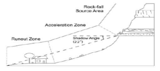
The city designates all rock fall hazard areas, regardless of any formal identification, as geologically hazardous areas. At a minimum, the following shall be considered suspected rock fall hazard areas for the purpose of determining the need for a preliminary evaluation:
(a) Areas within a 22-degree shadow angle extending from the base of a rock source; and
(b) Areas in which the city has a record of rock falls or in which there is visual evidence of past rock falls. (Ord. 829 § 21, 2021; Ord. 733 § 1 (Exh. A), 2012)
17.10.730 Classification.
The city of Entiat classifies geologically hazardous areas within the city and its urban growth area as follows:
(1) Known or Suspected Risk. Documentation or projection of the hazard by a qualified professional exists, or the area is designated as a suspected critical area.
(2) No Known Risk. Documentation or projection of the lack of hazard by a qualified professional exists.
(3) Risk Unknown. Data are not available to determine the presence or absence of a geologic hazard.
(4) Channel migration zone mapping has been completed for the Entiat River. (Ord. 733 § 1 (Exh. A), 2012)
17.10.740 Critical area review process for geologically hazardous areas.
(1) Preliminary Evaluation. In determining whether a preliminary evaluation is required for development in a given area, the administrator shall consider the geologic hazard classification. Any approved geotechnical assessment, geotechnical report, hydrogeologic evaluation, channel migration zone study, or other special or detailed study may be used to identify areas of known or suspected risk, unknown risk, or no known risk. The city may choose to use available data to map the approximate location and extent of geologically hazardous areas.
(2) Site Assessment and Report Requirements. Geological assessments and geotechnical reports shall be prepared in compliance with the following provisions. A geotechnical report contains all of the provisions of a geological assessment and shall be considered to meet the requirements of a geological assessment.
(a) A geological assessment shall include the following:
(i) Evaluate the actual presence of geologically hazardous areas within or in the vicinity of the site and the need for a geotechnical report. Specifically mention the circumstances or conditions which require the report to be prepared (steep slopes, erodible soils, suspected landslide or avalanche hazard, adverse hydrologic or flood risk, etc.).
(ii) Evaluate safety issues related to proposed activities. Address issues that could involve personal injury, worksite safety, or property damage.
(iii) Address existing geologic, topographic, and hydrologic conditions on the site, including an evaluation of the ability of the site to accommodate the proposed activity. Describe the proposed development, including property size and location, nature and extent of the planned development (i.e., house, garage, shop, swimming pool, etc.), and its specific location on the property. Include evidence of prior grading, excavation, cut banks, fill areas, or mining activity, and their potential impact on the project. Note and evaluate any features that could adversely affect development such as drainage gullies, erosion channeling, alluvial fans, evidence for debris flow or avalanche, surface creep and slope failure, observed or suspected spring activity and flood risk potential.
(iv) A discussion of the surface and subsurface geological and engineering properties of the soils, sediments, and/or rocks on the subject property and adjacent properties and their effect on the stability of the slope. Where known from field inspection or reference maps and literature, include bedrock identification and age, structural attitude with respect to slope inclination, fracturing, faults and shear zones, hydrothermal alteration, weathering characteristics, presence of landslide diamictite and its age and consolidation, etc. Use cross-sections if necessary for better representation of subsurface character.
(v) A description of the soils in accordance with the Unified Soil Classification System. Give general soil characteristics that could affect site development (i.e., frost action and shrink/swell potential, permeability, plasticity and wet/dry behavior, erodibility, etc.). Especially note the presence or suspected presence of clay-rich horizons and their position/location in the soil profile, and any indication that a building site could be subjected to differential soil compression or setting.
(vi) Evidence and history of avalanches, faults, significant geologic contacts, landslides, or downslope soil movement on the subject property and adjacent properties not detailed in subsection (2)(a)(iii) of this section.
(vii) A summary of the site assessment and its conclusions, mentioning the presence or absence of geohazards and site suitability. Include any recommendations for mitigation of potential hazards that can be dealt with without requiring a complete geotechnical report (control measures such as footing or intercept drainage systems, retaining walls, erosion control, vegetative management and restoration, and the probable need for engineering consultation and design).
(viii) A topographic map showing the proposed development site location and approximate parcel shape, location, boundaries, and all buildable space on the property.
(ix) Cite all references and information used in the assessment preparation, such as United States Geologic Survey (USGS) and Department of Natural Resources Geologic Maps and Bulletins, soil studies, surveys and previous reports.
(b) A geotechnical report shall include all of the information required for a geologic site assessment as well as the following:
(i) A contour map of the proposed site, at a scale of one inch equals 20 feet or as deemed appropriate by the administrator. Slopes shall be clearly delineated for the ranges between 15 and 29 percent, and 30 percent or greater, including figures for a real coverage of each slope category on the site. When site-specific conditions indicate the necessity, the administrator may require the topographic data to be field surveyed.
(ii) The location of springs, seeps, or other surface expressions of groundwater. The location of surface water or evidence of seasonal surface water runoff or groundwater.
(iii) The extent and type of vegetative cover prior to development activity or site disturbance.
(iv) A description of site history, including any prior grading, soil instability, or slope failure. Identify all existing fill areas.
(v) A determination regarding the appropriate hazard category or categories according to the classification of the geologically hazardous area consistent with EMC 17.10.730.
(vi) An explanation of soil characteristics and geologic, topographic, and hydrologic conditions of the site that might be expected to create a significant risk due to any geologic hazard and show the location of such hazardous areas. Specifically, include:
(A) Slope stability studies and opinion of slope stability;
(B) Erosion vulnerability of site;
(C) Suitability of on-site soil for fill;
(D) A summary of all subsurface exploration data, including subsurface soil profile, exploration logs, laboratory or in situ test results, and groundwater information and an interpretation and analysis of the subsurface data; and
(E) Building limitations.
(vii) A site development plan, drawn to scale, which shows the boundary lines and dimensions of the subject property, the location, size and type of any existing or proposed structures, impervious surfaces, wells, drainfields, drainfield reserve areas, roads, easements, and utilities proposed or located on site.
(viii) A hazard analysis evaluating the proposed alteration’s influence on the safety and stability of structures and any other risks of property damage, death, or injury resulting from development of the hazard area. Factors such as landscape irrigation, stormwater generation and the effect of street conveyance and utility placement should be included in the review of potential landslide and erosion hazard areas.
(ix) A description of appropriate mitigation measures, including specific design, development, and construction measures that will be taken to eliminate or minimize identified risks and to comply with the performance standards in EMC 17.10.750 (Performance standards). Specify any recommended setbacks and/or buffers. Include specific engineering recommendations for design and any geotechnical special provisions. Specifically, include:
(A) Proposed angles of cut and fill slopes and site grading requirements;
(B) Structural foundation requirements and estimated foundation settlements;
(C) Soil compaction criteria;
(D) Proposed surface and subsurface drainage; and
(E) Lateral earth pressures.
(x) A vegetation management and restoration plan or other means for maintaining long-term stability of slopes.
(xi) The proposed method of drainage and locations of all existing and proposed surface and subsurface drainage facilities and patterns, and the locations and methods for erosion control.
(xii) An erosion control plan that minimizes erosion (including both water and wind erosion) from all disturbed areas during construction and until permanent erosion control is achieved. Until the city adopts stormwater management regulations, the Stormwater Management Manual for Eastern Washington shall be the preferred guidance for erosion control measures.
(xiii) A monitoring program, to be marked on the face of the building permit.
(xiv) Information demonstrating compliance with all applicable codes and ordinances for the proposed development permit.
(3) Critical Area Study.
(a) A required critical area study for geologically hazardous areas shall include a geotechnical report adequate to assess any risks of property damage, death, or injury resulting from development of the hazard area and establish mitigation measures.
(b) If an applicant can demonstrate, through submittal of a geotechnical assessment, that no landslide or erosion hazards exist on site, the requirement for a geotechnical report may be waived by the administrator.
(c) Erosion and Landslide Hazard Areas. In addition to the basic report requirements, a critical area study for an erosion or landslide hazard area shall also meet the following requirements:
(i) A site plan showing:
(A) The height of slope, slope gradient, and cross-section of the project area;
(B) The location of springs, seeps, or other surface expressions of groundwater on or within 200 feet of the project area or that have potential to be affected by the proposal; and
(C) The location and description of surface water runoff features;
(ii) A hazards analysis that includes:
(A) A description of the extent and type of vegetative cover;
(B) A description of subsurface conditions based on data from site-specific explorations;
(C) Descriptions of surface and groundwater conditions, public and private sewage disposal systems, fills and excavations, and all structural improvements;
(D) An estimate of slope stability and the effect construction and placement of structures will have on the slope over the estimated life of the structure;
(E) An estimate of the bluff retreat rate that recognizes and reflects potential catastrophic events such as seismic activity or a 100-year storm event;
(F) Consideration of the run-out hazard of landslide debris and/or the impacts of landslide run-out on down slope properties;
(G) A study of slope stability including an analysis of proposed cuts, fills, and other site grading;
(H) Recommendations for building siting limitations; and
(I) An analysis of proposed surface and subsurface drainage, and the vulnerability of the site to erosion;
(iii) A geotechnical report prepared by a licensed engineer that presents engineering recommendations for the following:
(A) Parameters for design of site improvements including appropriate foundations and retaining structures. These should include allowable load and resistance capacities for bearing and lateral loads, installation considerations, and estimates of settlement performance;
(B) Recommendations for drainage and subdrainage improvements;
(C) Earthwork recommendations including clearing and site preparation criteria, fill placement and compaction criteria, temporary and permanent slope inclinations and protection, and temporary excavation support, if necessary; and
(D) Mitigation of adverse site conditions including slope stabilization measures and seismically unstable soils, if appropriate;
(iv) For any development proposal on a site containing an erosion hazard area, an erosion and sediment control plan prepared in accordance with the city’s stormwater management regulations, when adopted;
(v) A drainage plan providing for the collection, transport, treatment, discharge, and/or recycle of water, prepared in accordance with the city’s stormwater management regulations, when adopted. The drainage plan should consider on-site septic system disposal volumes where the additional volume will affect the erosion or landslide hazard area;
(vi) Hazard and environmental mitigation plans that include the location and methods of drainage, surface water management, locations and methods of erosion control, a vegetation management and/or replanting plan, and/or other means for maintaining long-term soil stability; and
(vii) If the administrator determines that there is a significant risk of damage to downstream receiving waters due to potential erosion from the site, based on the size of the project, the proximity to the receiving waters, or the sensitivity of the receiving waters, the technical information shall include a plan to monitor the surface water discharge from the site. The monitoring plan shall include a recommended schedule for submitting monitoring reports to the city.
(d) Seismic Hazard Areas. In addition to the general critical area study requirements specified in Article VII of this chapter, a critical area study for a seismic hazard area shall also meet the following requirements:
(i) The site map shall show all known and mapped faults that are within 250 feet of the project area or that have potential to significantly affect or to be affected by the proposal.
(ii) The hazards analysis shall include a complete discussion of the potential impacts of seismic activity on the site (for example, forces generated and fault displacement).
(iii) A geotechnical engineering report shall evaluate the physical properties of the subsurface soils, especially the thickness of unconsolidated deposits and their liquefaction potential. If it is determined that the site is subject to liquefaction, mitigation measures appropriate to the scale of the development shall be recommended and implemented.
(e) Rock Fall Hazard Areas. In addition to the basic report requirements, a critical area study for a rock fall hazard area shall also meet the following requirements:
(i) Any required critical area study for a rock fall hazard area shall be prepared by a geotechnical consultant familiar with rock fall hazards;
(ii) The study shall include a geologic vicinity map, at an appropriate scale (typically 1:24,000) and with references, showing the general surface geology (landslides, alluvial fans, etc.), bedrock geology where exposed, bedding attitudes, faults, other geologic structural features, and location of any rock fall hazards;
(iii) The hazards analysis shall include an evaluation of available remote sensing data, which may include aerial photographs, oblique aerial photographs, and DEMs derived from detailed topography and/or LIDAR, for the potential presence of geologic hazards;
(iv) The study shall include final design plans and specifications for engineered mitigation signed and stamped by a qualified geotechnical engineer. If the geologic report is submitted with a land use application that is reviewed prior to the construction or building plans (e.g., preliminary plat or conditional use permit), the engineering level design and calculations of the improvement do not need to be submitted until after a land use approval is obtained and construction approval is requested. However, the proposed methods must still be identified;
(v) The study shall include a statement regarding the suitability of the site for the proposed development from a rock fall-hazard perspective.
(f) Where a geotechnical report has been prepared and approved by the city within the last five years for a specific site, and where the proposed activity and surrounding site conditions are unchanged (or, in the case an individual lot within a subdivision, where the only changes in surrounding site conditions are development and mitigation as specified in the report), said report may be used and a new report may not be required. The applicant shall submit a geotechnical assessment detailing any changed environmental conditions associated with the site. (Ord. 829 § 21, 2021; Ord. 733 § 1 (Exh. A), 2012)
17.10.750 Performance standards.
(1) Any development or other alteration that would pose a foreseeable risk to the public, public or private resources and facilities, or the natural environment is prohibited.
(2) The following standards apply to all development within geologically hazardous areas:
(a) Development shall not increase instability or create a hazard to the site or adjacent properties, or result in a significant increase in sedimentation or erosion. Construction methods shall minimize risks to structures and shall not increase the risk to the site, or to adjacent properties and their structures, from the geologic hazard.
(b) Site planning shall minimize disruption of existing topography and natural vegetation, and where feasible shall incorporate opportunities for phased clearing.
(c) Disturbed areas shall be replanted within one year of project completion, in accordance with an approved revegetation plan.
(d) Impervious surface coverage shall be minimized.
(e) Excavation and grading shall be limited to the minimum necessary to accomplish engineering design. The clearing and grading schedule shall consider limitations based upon seasonal weather conditions.
(f) Any limitations to site disturbance, such as clearing restrictions, imposed as a condition of development approval should be marked in the field and approved by the city prior to undertaking the project.
(g) All authorized clearing for roads, utilities, etc., should be limited to the minimum necessary to accomplish engineering design. Alterations should meet the following requirements:
(i) Clearing, grading or filling of sloped sites containing erosion or landslide hazard areas should be limited by weather conditions and an approved erosion control plan;
(ii) All clearing shall be marked in the field for inspection and approval prior to alteration of the site;
(iii) The face of cut and fill on slopes shall be prepared and maintained to control against erosion.
(3) The following additional standards apply to erosion hazard areas:
(a) In order to prevent or mitigate potential hazards to life, property or the natural environment, development in or adjacent to erosion hazard areas shall be discouraged. No public or private development will be permitted in erosion hazard areas where mitigation approved by the city and adequate to protect members of the public and public and private resources and facilities from injury, loss of life, property damage or financial losses due to erosion, landslide, seismic events or steep slope failure is not feasible.
(b) Alterations.
(i) Alterations of an erosion hazard area may occur only for activities for which a hazards analysis is submitted and certifies that:
(A) The development will not increase surface water discharge or sedimentation to adjacent properties beyond predevelopment conditions;
(B) The development will not decrease slope stability on adjacent properties; and
(C) The alterations will not adversely impact other critical areas.
(ii) Excavation and grading shall be minimized in all erosion and steep slope areas and shall comply in full with the relevant provisions of building codes adopted by the city.
(c) Development within an erosion or landslide hazard area or buffer shall be designed to meet the following basic requirements unless it can be demonstrated that an alternative design provides greater long-term slope stability while meeting all other provisions of this chapter. The requirement for long-term slope stability shall exclude designs that require regular maintenance to maintain their level of function. The basic requirements are:
(i) The proposed development shall not decrease the factor of safety for landslide occurrences below the limits of 1.5 for static conditions and 1.2 for dynamic conditions. Analysis of dynamic conditions shall be based on a minimum horizontal acceleration as established by the current version of the Uniform Building Code;
(ii) Structures and improvements shall be clustered to avoid geologically hazardous areas and other critical areas;
(iii) Structures and improvements shall minimize alterations to the natural contour of the slope, and foundations shall be tiered where possible to conform to existing topography;
(iv) Structures and improvements shall be located to preserve the most critical portion of the site and its natural landforms and vegetation;
(v) The proposed development shall not result in greater risk or a need for increased buffers on neighboring properties;
(vi) Retaining walls that allow the maintenance of existing natural slope area are preferred to graded artificial slopes; and
(vii) Development shall be designed to minimize impervious lot coverage;
(d) Unless otherwise provided or as part of an approved alteration, removal of vegetation from an erosion or landslide hazard area or related buffer shall be prohibited;
(e) Clearing shall be allowed only during the dry season, which shall depend on actual weather conditions but is generally considered to run from May through September.
(f) Utility lines and pipes shall be permitted in erosion and landslide hazard areas only when the applicant demonstrates that no practical alternative is available. The line or pipe shall be located above ground and properly anchored and/or designed so that it will continue to function in the event of an underlying slide. Stormwater conveyance shall be allowed only through a high-density polyethylene pipe with fuse-welded joints, or similar product that is technically equal or superior.
(g) Point discharges from surface water facilities and roof drains onto or upstream from an erosion or landslide hazard area shall be prohibited except as follows:
(i) Discharge is conveyed via continuous storm pipe down slope to a point where there are no erosion hazard areas downstream from the discharge;
(ii) Water is discharged at flow durations matching predevelopment conditions, with adequate energy dissipation, into existing channels that previously conveyed stormwater runoff in the predeveloped state; or
(iii) Discharge is dispersed up-slope of the steep slope onto a low-gradient undisturbed buffer demonstrated to be adequate to infiltrate all surface and stormwater runoff, and where it can be demonstrated that such discharge will not increase the saturation of the slope.
(h) On-site sewage disposal systems, including drain fields, shall be prohibited within erosion hazard areas and related buffers.
(i) Development may occur in steep slope areas only after the following standards have been met:
(i) Development must be located to minimize disturbance and removal of vegetation and also to protect the most sensitive areas (including areas of erosive soils, areas at risk of erosion by wind or water, and areas of dense vegetation) and retain open space. The use of continuous greenbelt areas shall be encouraged; and
(ii) Structures must be clustered where possible to reduce disturbance and maintain natural topographic character. Common access driveways shall be considered as a means of reducing construction disturbances; and
(iii) Where possible, structures must conform to the natural contour of the slope and foundations must be tiered to conform to existing topography of the site.
(j) Unless a grading plan prepared by a licensed civil engineer is provided and approved by the administrator, disturbance of a development site shall generally not exceed the following for the slope categories indicated:
|
Slope Category |
Factor |
|---|---|
|
Slopes 30 – 40% (60% of the site or more) |
.60 |
|
Slopes 40% + (also see landslide hazard area) |
.30 |
The overall amount of disturbance allowed on development sites which have any combination of the above slope categories shall be determined by the following formula:
(Square footage of the area within the slope category x slope factor) = Total amount of allowable disturbance for that slope classification.
The total amount of allowable disturbance for the site is the sum of all the allowable disturbance totals for each slope category.
(4) The following additional standards apply to landslide hazard areas:
(a) Areas identified as landslide hazard areas or within 250 feet of landslide hazard areas shall be altered only when the administrator concludes, based on environmental information provided by a qualified professional, that:
(i) There will be no increase in surface water discharge or sedimentation to adjacent properties; and
(ii) There will be no decrease in slope stability on adjacent properties; and
(iii) Either:
(A) There is no evidence of recent landslides in the vicinity of the proposed development, and a quantitative analysis of slope stability indicates no significant risk to the proposed development, adjacent properties, or the health or safety of humans or the environment; or
(B) The hazard can be mitigated, modified or the project can be designed so that the risk (including risks to the project and risks beyond the project site) is no greater than the risk posed by development on a site without a landslide hazard; or
(C) The proposal is so minor as not to pose a threat.
(b) The following standards apply to all development in landslide hazard areas:
(i) Disturbance of trees and vegetation shall be minimized in and within 250 feet of landslide hazard areas in order to prevent erosion, stabilize slopes, and preserve the natural character of the area;
(ii) Structures and improvements shall be located to preserve the most sensitive portion of the site and its natural landforms and vegetation.
(c) A buffer shall be established from all edges of landslide hazard areas. The size of the buffer shall be determined by the administrator to eliminate or minimize the risk of property damage, death, or injury resulting from landslides caused in whole or part by the development, based upon review of and concurrence with a critical area study prepared by a qualified professional.
(d) Alterations. Alterations of a landslide hazard area or its buffer may occur only for activities for which a hazards analysis is submitted and certifies that:
(i) The development will not increase surface water discharge or sedimentation to adjacent properties beyond predevelopment conditions;
(ii) The development will not decrease slope stability on adjacent properties; and
(iii) The alterations will not adversely impact other critical areas.
(e) Subdivision.
(i) Land that is located wholly within a landslide hazard area or its buffer may not be subdivided.
(ii) Land that is located partially within a landslide hazard area or its buffer may be divided provided that each resulting lot has sufficient buildable area outside of, and will not affect, the landslide hazard or its buffer.
(iii) Access roads and utilities may be permitted within a landslide hazard area and associated buffers if the city determines that no other feasible alternative exists.
(f) On-site sewage disposal systems, including drain fields, shall be prohibited within landslide hazard areas and related buffers.
(5) Seismic Hazard Areas. All development activities in seismic hazard areas shall conform to the applicable building code.
(6) Rock Fall Hazard Areas. Development of structures intended for human occupancy or critical facilities in a rock fall hazard area shall be discouraged unless the hazard is mitigated to an acceptable and reasonable risk level, based on information provided by a qualified professional who is a geotechnical consultant familiar with rock fall hazards. Development of any such structure in a rock fall hazard area in which the hazard is not mitigated to an acceptable and reasonable risk level shall require a recorded waiver of liability. (Ord. 733 § 1 (Exh. A), 2012)