


Chapter 16.16
CRITICAL AREAS
Sections:
I. FINDINGS OF FACT, STATEMENT OF PURPOSE, GENERAL PROVISIONS, AND SEVERABILITY
16.16.020 Statement of purpose.
II. DEFINITIONS
III. ADMINISTRATION
16.16.070 Determinations of critical areas and their boundaries.
16.16.090 Allowed activities – Road and utility rights-of-way.
16.16.100 Nonconforming activities.
16.16.110 Reasonable use exception.
16.16.120 Preapplication meeting.
16.16.130 Submittal requirements.
16.16.140 Time period for review.
16.16.150 Inspection and right of entry.
16.16.170 Modification of permits.
16.16.190 Violations and enforcement.
16.16.200 Temporary emergency permit.
16.16.210 Critical area tracts.
16.16.220 Lot potential mitigation.
IV. WETLANDS
16.16.250 Permitted uses in a wetland buffer zone.
16.16.260 Allowed alteration to wetland buffer zone.
16.16.270 Reasonable use exception – Additional requirements for wetlands.
16.16.280 Wetland alteration or replacement provisions.
V. AREAS OF SPECIAL FLOOD HAZARD
16.16.290 Areas of special flood hazard.
VI. STREAMS AND SHORELINES
16.16.300 Stream rating system.
16.16.310 Streams and shorelines buffers.
16.16.320 Permitted uses in streams and shorelines buffer zone.
16.16.330 Allowed alteration to streams and shorelines buffer zone.
16.16.340 Reasonable use exception – Additional requirements for streams and shorelines.
16.16.350 Streams and shorelines alteration or replacement provisions.
VII. GEOLOGIC HAZARD AREAS
16.16.360 Development in geologically hazardous areas.
16.16.370 Allowed alterations to geologically hazardous areas.
VIII. FISH AND WILDLIFE HABITAT
16.16.380 Priority habitats areas.
IX. CRITICAL AQUIFER
RECHARGE AREAS
16.16.390 Critical aquifer recharge areas.
Appendix B Rationale for Buffer Dimensions and Restrictions
Appendix D Native Vegetation for Buffers, Revegetation and Mitigation Projects
I. FINDINGS OF FACT, STATEMENT OF PURPOSE, GENERAL PROVISIONS, AND SEVERABILITY
16.16.010 Findings of fact.
The town of Index hereby finds that:
(A) Critical areas and their buffers are valuable and fragile natural resources with significant development constraints due to flooding, erosion, septic disposal limitations, and land slide hazard.
(B) The state of Washington has enacted a Growth Management Act (Chapter 36.70A RCW), and under this Act the town of Index is adopting regulations protecting environmentally critical areas such as wetlands, critical aquifer recharge areas, fish and wildlife habitat conservation areas, frequently flooded areas, and geologically hazardous areas.
(C) In their natural state, wetlands provide many valuable social and ecological services, including:
(1) Controlling flooding and stormwater runoff by storing or regulating natural flows;
(2) Protecting water resources by filtering out water pollutants, processing biological and chemical oxygen demand, recycling and storing nutrients, and serving as settling basins for naturally occurring sedimentation;
(3) Providing areas for surface water recharge;
(4) Preventing shoreline erosion by stabilizing the substrate;
(5) Providing habitat areas for many species of fish, wildlife, and vegetation, many of which are dependent on wetlands for their survival, and many of which are on Washington State and Federal Endangered Species lists;
(6) Providing open space and visual relief from intense development in urbanized areas;
(7) Providing recreation opportunities; and
(8) Serving as areas for scientific study and natural resource education.
(D) Frequently flooded and geologically hazardous areas shall be preserved in order to protect public and private resources and facilities from injury, loss of life, and property or financial damage due to flooding, erosion, landslides, or steep slope failure.
(E) Development in critical areas can result in:
(1) Increased soil erosion and sedimentation of downstream water bodies;
(2) Increased shoreline erosion;
(3) Degraded water quality due to increased turbidity and loss of pollutant removal processes;
(4) Elimination or degradation of wildlife and fisheries habitat;
(5) Loss of fishery resources from water quality degradation, increased peak flow rates, decreased summer low flows, and changes in the streamflow regimen;
(6) Loss of stormwater retention capacity and slow-release detention resulting in flooding, degraded water quality, and changes in the streamflow regimen of watersheds;
(7) Loss of ground water recharge areas;
(8) Loss of slope and soil stability caused by the removal of trees, shrubs, and root systems of vegetative cover on steep slopes.
(F) Buffer areas and building setbacks (if required) surrounding critical areas are essential to maintenance and protection of critical area functions. Buffer areas protect critical areas from degradation by:
(1) Stabilizing soil and preventing erosion;
(2) Filtering suspended solids, nutrients and harmful or toxic substances;
(3) Moderating impacts of stormwater runoff;
(4) Moderating system microclimate;
(5) Protecting wetland wildlife habitat from adverse impacts;
(6) Maintaining and enhancing habitat diversity and/or integrity;
(7) Supporting and protecting wetlands plant and animal species and biotic communities;
(8) Reducing disturbances to wetland resources caused by intrusion of humans and domestic animals;
(9) Protecting steep slopes from erosion and landslides.
(G) It is therefore the policy of the town of Index to ensure protection for critical areas by regulating or prohibiting development activities in critical areas; and discouraging or prohibiting development activities within critical area buffers. (Ord. 465 § 1 (part), 2017: Ord. 461 § 1.1, 2017: Ord. 361 § 1.1, 2002).
16.16.020 Statement of purpose.
It is the policy of the town of Index to require site planning to prohibit damage to critical areas wherever possible, and to establish criteria to balance the rights of property owners with the preservation of critical areas.
In addition, it is the intent of the town of Index that activities in or affecting critical areas not threaten public safety, cause nuisances, or destroy or degrade critical areas by:
(A) Impeding flood flows, reducing flood storage capacity, or impairing natural flood control functions, thereby resulting in increased flood heights, frequencies, or velocities on other lands;
(B) Increasing water pollution through location of domestic waste disposal systems in wetlands; unauthorized application of pesticides and herbicides; disposal of solid waste in inappropriate sites; creation of unstable fills; or the destruction of wetland soils and vegetation;
(C) Increasing erosion and landslide hazard;
(D) Decreasing breeding, nesting, and feeding areas for rare and endangered species of wildlife;
(E) Interfering with the exchange of nutrients needed by fish and other forms of wildlife;
(F) Decreasing habitat for fish and other forms of wildlife;
(G) Adversely altering the recharge or discharge functions of wetlands, thereby impacting ground water or surface water supplies;
(H) Significantly altering wetland hydrology and thereby causing either short-term or long-term changes in vegetative composition, soils characteristics, nutrient cycling, or water chemistry;
(I) Destroying sites needed for education or scientific research, such as outdoor biophysical laboratories, living classrooms, and training areas;
(J) Interfering with public rights for passive recreational opportunities provided by wetlands such as bird watching, photography, hiking and similar uses;
(K) Destroying or damaging property values.
The purpose of this chapter is to protect public health, safety, and welfare by preventing the adverse environmental impacts of development enumerated in this section and Section 16.16.010 by:
(A) Preserving and protecting critical areas by regulating development within critical areas and their buffers;
(B) Protecting the public against losses from:
(1) Unnecessary maintenance and replacement of public facilities;
(2) Publicly funded mitigation of avoidable impacts;
(3) Cost for public emergency rescue and relief operations; and
(4) Potential litigation from improper construction practices;
(C) Alerting appraisers, assessors, owners, and potential buyers or lessees to the development limitations of properties on which critical areas or required buffer areas are located;
(D) Providing town of Index officials with information to evaluate, approve, condition, or deny public or private development proposals.
(E) This chapter will be revised and updated as needed and/or required. (Ord. 465 § 1 (part), 2017: Ord. 461 § 1.2, 2017: Ord. 361 § 1.2, 2002).
16.16.030 General provisions.
Interpretation. The provisions of this chapter shall be held to be minimum requirements in their interpretation and application and shall be liberally construed to serve the purposes of this chapter. (Ord. 465 § 1 (part), 2017: Ord. 461 § 1.3, 2017: Ord. 361 § 1.3, 2002).
16.16.040 Severability.
If any clause, sentence, paragraph, section or part of this chapter or the application thereof to any person or circumstances shall be adjudged by any court of competent jurisdiction to be invalid, such order or judgement shall be confined in its operation to the controversy in which it was rendered and shall not affect or invalidate the remainder of any part thereof to any other person or circumstances and to this end the provisions of each clause, sentence, paragraph, section or part of this law are hereby declared to be severable. (Ord. 465 § 1 (part), 2017: Ord. 461 § 1.4, 2017: Ord. 361 § 1.4, 2002).
II. DEFINITIONS
16.16.050 Definitions.
For the purposes of this chapter, the following definitions shall apply:
“Administrator” means the mayor or mayor’s designee.
“Applicant” means a person who files an application for permit under this chapter and who is either the owner of the land on which that proposed activity would be located, a contract vendee, a lessee of the land, the person who would actually control and direct the proposed activity, or the authorized designee of such a person.
“Aquifer” means a layer of ground that allows water to pass through easily.
“Area of special flood hazard” means the land in the floodplain within a community subject to a one percent (1%) or greater chance of flooding in any given year. It is shown on the flood insurance rate map (FIRM) as zone A, AO, AH, A1-30, AE, A99, or AR (V, VO, V1-30, VE). “Special flood hazard area” and “frequently flooded areas” are synonymous in meaning with the phrase “area of special flood hazard.”
“Best management practices” means conservation practices or systems of practices and management based on best available science measures that:
(1) Control soil loss and reduce water quality degradation caused by nutrients, animal waste, toxins, and sediment; and
(2) Minimize adverse impacts to surface and ground water flow, circulation patterns, and to the chemical, physical, and biological characteristics of critical areas.
“Critical area buffer” or “critical area buffer zone” is an area that surrounds and protects a critical area from adverse impacts.
“Critical areas” includes the following:
1. Wetlands;
2. Areas of special flood hazard;
3. Shorelines and shorelands;
4. Geologically hazardous areas and steep slopes;
5. Fish and wildlife habitat areas; and
6. Critical aquifer recharge areas.
“Critical areas permit” means any permit issued, conditioned or denied specifically to implement this chapter.
“Critical habitat” means habitat necessary for the survival of endangered, threatened, rare, or sensitive species.
“Developable area” means an area of land outside of critical areas and their buffers.
“Development activity” means any construction, development, earth movement, clearing or any other site disturbance.
“Erosion hazard areas” are those areas containing soils which, according to the United States Department of Agriculture Soil Conservation Service Soil Classification System, may experience severe to very severe erosion, or soils on slopes greater than forty percent (40%).
“Exotic” means any species of plants or animals that are foreign to the planning area.
“Fish and wildlife habitat areas” include the following:
(1) Areas with which endangered, threatened, and sensitive species have a primary association;
(2) Naturally occurring ponds under twenty (20) acres and their submerged aquatic beds that provide fish or wildlife habitat;
(3) Waters of the state as defined in RCW 90.48.020;
(4) Lakes, ponds, streams, and rivers planted with game by a governmental or tribal entity.
“Floodway” means those portions of the area of a river valley lying streamward from the outer limits of a watercourse, and upon which flood waters are carried during periods of flooding that occur with reasonable regularity, though not necessarily annually. The floodway is identified, under normal conditions, by changes in surface soil conditions, or changes in types or quality of vegetative groundcover conditions. The floodway does not include lands that can reasonably be expected to be protected from flood waters by flood control devices maintained by or under license from the federal government, the state, or a political subdivision of the state. The limits of the floodway are based on flood regulation ordinance maps or by a reasonable method which meets the objectives of the Shoreline Management Act (RCW 90.58.030(2)(g) or its successor; WAC 173-22-030(5) or its successor).
“Functions” or “functions and values” means the beneficial roles served by critical areas including, but not limited to, water quality protection and enhancement, fish and wildlife habitat, food chain support, sediment transport and deposition, sediment removal and filtration, microclimate and temperature regulation, flood storage, conveyance and attenuation, ground water recharge and discharge, erosion control, landslide control, and recreational opportunities. These beneficial roles are not listed in order of priority.
“Geologically hazardous areas” are areas that because of their susceptibility to erosion, sliding, earthquake, or other geological events, are not suited to siting residential, commercial, or industrial development consistent with public health or safety concerns. Geologically hazardous areas include “landslide hazard areas,” “steep slopes” and “erosion hazard areas.”
“Geotechnical report” means a scientific study or evaluation conducted by a qualified expert that includes a description of the site hydrology and geology, the affected land form and its susceptibility to mass wasting, conclusions and recommendations regarding the effect of the proposed development on geologic conditions, the adequacy of the site to be developed, the impacts of the proposed development, alternative approaches to the proposed development, and measures to mitigate potential site specific and cumulative impacts of the proposed development including the potential adverse impacts to adjacent and downstream material resource.
Geotechnical reports shall conform to accepted technical standards and must be prepared by qualified engineers or geologists who are knowledgeable about the regional and local geology.
“Ground water” means water in a saturated zone or stratum beneath the surface of land or a surface water body.
“High intensity land use” includes land uses which are associated with moderate or high levels of human disturbance or substantial wetland habitat impacts including, but not limited to, medium and high density residential, multifamily residential, active recreation, and commercial and industrial land uses.
“Hydric soil” means a soil that is saturated, flooded or ponded long enough during the growing season to develop anaerobic conditions in the upper part. The presence of hydric soil shall be determined following the methods described in the most current edition of the approved federal wetland delineation manual and applicable regional supplements.
“Hydrophytic vegetation” means macrophytic plant life growing in water or on a substrate that is at least periodically deficient in oxygen as a result of excessive water content. The presence of hydrophytic vegetation shall be determined following the methods described in the most current edition of the approved federal wetland delineation manual and applicable regional supplements.
“Isolated wetlands” means those regulated wetlands which:
(1) Are outside of and not contiguous to any one hundred (100) year floodplain or a lake, river, or stream; and
(2) Have no contiguous hydric soils or hydrophytic vegetation between the wetland and any surface water.
“Landslide” refers to zones of erosion, transport, and deposition.
“Landslide hazard areas” are areas at risk of mass movement due to a combination of geologic, topographic, and hydrological factors, as delineated in WAC 365-190-120(6).
“Low intensity land use” includes land uses which are associated with low levels of human disturbance or low wetland habitat impacts, including, but not limited to, low density single-family residential with adequate sewer and stormwater retention/detention/biofiltration facilities, passive recreation, open space, or forest management land uses.
“Mitigation” means the process of avoiding, reducing or compensating for the environmental impact(s) of a proposal, including the following listed in the order of sequence priority. Measure 1 shall be applied first and subsequent measures applied only after higher priority measures are demonstrated to be not feasible or applicable:
(1) Avoiding the impact altogether by not taking a certain action or parts of an action;
(2) Minimizing impacts by limiting the degree or magnitude of the action and its implementation, by using the appropriate technology, or by taking affirmative steps to avoid or reduce impacts;
(3) Rectifying the impact by repairing, rehabilitating or restoring the affected environment;
(4) Reducing or eliminating the impact over time by preservation and maintenance operations during the life of the action;
(5) Compensating for the impact by replacing, enhancing, or providing substitute resources and environments; and
(6) Monitoring the impact and the compensation projects and taking appropriate corrective measures.
“Monitoring” means evaluating the impacts of development proposals on the biological, hydrological, and geological elements of such systems and assessing the performance of required mitigation measures throughout the collection and analysis of data by various methods for the purpose of understanding and documenting changes in natural ecosystems and features, and includes gathering baseline data.
“Native vegetation” means plant species that are indigenous to the area of question.
“Ordinary high water mark (OHM)” is that mark which is found by examining the bed and banks and ascertaining where the presence and action of waters are so common and usual, and so long continued in all ordinary years, that the soil has a character distinct from that of the abutting upland in respect to vegetation.
“Ordinary residential improvement” means improvements to those structures and facilities which are commonly found with and are incidental to the development and use of a single-family residence, including but not limited to garages, decks, driveways and serving utility systems.
“Practicable alternative” means an alternative that is available and capable of being carried out after taking into consideration cost, existing technology, and logistics in light of overall project purposes, and having less impacts to critical areas.
“Priority habitat” means a habitat type with unique or significant value to one (1) or more species. Priority habitat is derived from the Washington Department of Fish and Wildlife’s manual “Management Recommendations for Washington’s Priority Habitats.” An area classified and mapped as priority habitat must have one (1) or more of the following attributes:
(1) Comparatively high fish and wildlife density;
(2) Comparatively high fish and wildlife species diversity;
(3) Important fish and wildlife breeding habitat;
(4) Important fish and wildlife seasonal ranges;
(5) Important fish and wildlife movement corridors;
(6) Limited availability;
(7) High vulnerability to habitat alteration; or
(8) Unique or dependent species.
A priority habitat may be described by a unique vegetation type or by a dominant plant species that is of primary importance to fish and wildlife such as oak woodlands or eelgrass meadows. A priority habitat may also be described by a successional stage such as old growth and mature forests. Alternatively, a priority habitat may consist of a specific habitat element such as consolidated marine/estuarine shorelines, talus slopes, caves, or snags of key value to fish and wildlife. A priority habitat may contain priority and/or nonpriority fish and wildlife.
“Priority species” means fish and wildlife species requiring protective measures and/or management guidelines to ensure their perpetuation. Priority species is derived from the Washington Department of Fish and Wildlife’s manual “Management Recommendations for Washington’s Priority Habitats.” Priority species are those that meet any of the criteria listed below:
(1) Criterion l: State-listed or state candidate species. State-listed species are those native fish and wildlife species legally designated as endangered (WAC 232-12-014), threatened (WAC 232-12-011), or sensitive (WAC 232-12-011). State candidate species are those fish and wildlife species that will be reviewed by the Department of Fish and Wildlife (POL-M-6001) for possible listing as endangered, threatened, or sensitive according to the process and criteria defined in WAC 232-12-297. Federal candidate species are evaluated individually to determine their status in Washington and whether inclusion as a priority species is justified.
(2) Criterion 2: Vulnerable aggregations. Vulnerable aggregations include those species or groups of animals susceptible to significant population declines, within a specific area or state-wide, by virtue of their inclination to congregate. Examples include heron rookeries, seabird concentrations, marine mammal haulouts, shellfish beds, and fish spawning and rearing areas.
(3) Criterion 3: Species of recreational, commercial and/or tribal importance. Native and nonnative fish, shellfish, and wildlife species of recreational or commercial importance and recognized species used for tribal ceremonial and subsistence purposes that are vulnerable to habitat loss or degradation.
(4) Criterion 4: Species listed under the Endangered Species Act as either threatened or endangered.
“Qualified professional” means a person whose qualifications and expertise are appropriate to the relevant activity, and who possesses professional credentials and/or certification. This may include any advanced degrees earned in the pertinent scientific discipline from a recognized university, the number of years of experience in the pertinent scientific discipline, formal training in the specific area of expertise, and field and/or laboratory experience. Where pertinent scientific information implicates multiple scientific disciplines, applicants are encouraged to consult multiple qualified professionals representing the various disciplines to ensure the identification and inclusion of the best available science.
“Reasonable use” means the use a property owner is entitled to by virtue of the due process clauses of the State and Federal Constitution as well as the use necessary to prevent a taking without just compensation as prohibited by the takings clauses of the State and Federal Constitutions.
“Recharge area” means an area that allows water to enter the aquifer.
“Regulated activities” means any development activity within the corporate limits of the town of Index which is of a scope that would require issuance of any local, state, or federal permit and is located on the same lot as a critical area and/or critical areas buffer.
“Repair or maintenance” means an activity that restores the character, scope, size, and design of a serviceable area, structure, or land use to its previously authorized and undamaged condition. Activities that change the character, size, or scope of a project beyond the original design, such as draining, dredging, filling, flooding, or otherwise altering additional wetlands are not considered to be repair or maintenance.
“Serviceable” means presently usable.
“Shorelands” or “shoreland areas” means those lands extending landward for two hundred (200) feet in all directions as measured on a horizontal plane from the ordinary high water mark; floodways and contiguous floodplain areas landward two hundred (200) feet from such floodways; and all wetlands and river deltas associated with the streams, lakes and tidal waters which are subject to the provisions of the Washington State Shorelines Management Act of 1971.
“Shorelines” means all of the water areas of the state, including reservoirs and their associated shorelands, together with the lands underlying them except:
(1) Shorelines of state-wide significance;
(2) Shorelines on segments of streams upstream of a point where the mean annual flow is twenty (20) cubic feet per second or less and the wetlands associated with such upstream segments;
(3) Shorelines on lakes less than twenty (20) acres in size and wetlands associated with such small lakes.
“Shorelines of state-wide significance” are those areas defined within RCW 90.58.030.
“Soil bio-engineering techniques” is an applied science that combines structure, biological, and ecological concepts to construct living structures that stabilize the soil to control erosion, sedimentation, and flooding, using live plant materials as a main structural component.
“Steep slopes” referenced in this chapter are landslide hazard areas as defined in WAC 365-190-120(6).
“Stormwater” means surface water runoff collected and transported by a managed system.
“Stream” means an area where surface waters flow almost continuously. If a stream dries up after a day of rain or only flows during an intense storm it is not considered a “stream.” If, however, it is still flowing a week after rainfall it is considered a stream. “Stream” also includes any watercourse, natural or manmade, into which fish have moved.
“Substantially degrade” means to cause damage or harm to an area’s natural ecological functions. An action is considered to substantially degrade the environment if:
(1) The damaged ecological function or functions affect other related functions or the viability of the larger ecosystem;
(2) The damage is not reversed or self-correcting through natural means within approximately two (2) years;
(3) There is the threat, as determined by best available science, that the degrading action could cause significant damage to shoreline ecological functions under foreseeable conditions; and/or
(4) There is the threat that the action could contribute to damaging ecological functions as part of cumulative impacts from similar permitted activities on nearby shorelines.
“Surface water” means a body of water open to the atmosphere.
“Town of Index” refers to the incorporated town of Index.
“Unavoidable and necessary impacts” are impacts to critical areas that remain after a person proposing to alter critical areas has demonstrated that no practicable alternatives exist to the proposed project.
“Water-dependent” means requiring the use of surface water that would be essential to fulfill the purpose of the proposed project.
“Wetland edge” means the boundary of a wetland based on the definitions contained in this chapter.
“Wetlands” shall be those areas that are inundated or saturated by surface or ground water at a frequency and duration sufficient to support, and that under normal circumstances do support, a prevalence of vegetation, typically adapted for life in saturated soil conditions. Wetlands generally include natural ponds, swamps, marshes, bogs, and similar areas. Wetlands do not include those artificial wetlands intentionally created from nonwetland sites, including, but not limited to, irrigation and drainage ditches, canals, detention facilities, wastewater treatment facilities, farm ponds, and landscape amenities, or those wetlands created after July 1, 1990, that were unintentionally created as a result of the construction of a road, street, or highway. Wetlands may include those artificial wetlands intentionally created from nonwetland areas to mitigate the conversion of wetlands. (Ord. 504 § 1, 2023; Ord. 466 § 1, 2017; Ord. 465 § 1 (part), 2017: Ord. 461 § 2, 2017: Ord. 361 § 2, 2002).
III. ADMINISTRATION
16.16.060 Applicability.
(A) No development activity is authorized within a critical area or critical area buffer unless expressly authorized by this chapter or by a critical areas permit. No regulated activity may be undertaken without an approved critical areas application unless the activity is expressly exempted from this chapter.
(B) Compliance with the requirements of this chapter shall be required for the issuance of a critical areas permit. Planning commission members will receive the completed application for review during the regularly scheduled planning commission meetings which are open to the public. The planning commission members will then forward the application and their recommendations to the Index town council for review during the council meetings which are open to the public. The town council will approve and enforce the permitting process upon finding that the proposed regulated activity complies with all applicable provisions of this chapter. The mayor or his/her designee shall be responsible for facilitation of this process.
(C) Nothing in this chapter shall be construed to excuse compliance with any applicable federal, state, or local statute, ordinance, or regulation applicable to the subject property or to the regulated activity including the rules promulgated under the authority of this chapter.
(D) When any provision of any other ordinance of the town of Index conflicts with this chapter, that which provides more protection to critical areas and their buffers shall apply unless specifically provided otherwise in this chapter. (Ord. 465 § 1 (part), 2017: Ord. 461 § 3.1, 2017: Ord. 361 § 3.1, 2002).
16.16.070 Determinations of critical areas and their boundaries.
(A) The town of Index has designated critical areas by defining their characteristics. As an aid to both compliance and enforcement, a map showing known critical areas and their buffers within the town of Index can be found in Appendix C. As maps are an approximation only, the applicant shall determine, and the town shall verify, by field inspection on a case-by-case basis, in accordance with Section 16.16.050, whether a critical area exists and is regulated under this chapter on or in close enough proximity to the subject property that a habitat management plan, setback, or buffer would be required under this chapter. In the event of conflict between delineation made by maps contained in this chapter and conditions found in the field, the conditions found in the field shall prevail.
(B) The following types of critical areas are within the scope of this chapter:
(1) Wetlands (Article IV of this chapter);
(2) Frequently flooded areas (Article V of this chapter);
(3) Streams and shorelines (Article VI of this chapter);
(4) Geologic hazard areas (Article VII of this chapter);
(5) Fish and wildlife habitat (Article VIII of this chapter);
(6) Critical aquifer recharge areas (Article IX of this chapter).
(C) For each type of critical area as listed above, detailed requirements for regulated activities and permit application submittal requirements shall be contained in the applicable sections of this chapter. (Ord. 465 § 1 (part), 2017: Ord. 461 § 3.2, 2017: Ord. 361 § 3.2, 2002).
16.16.080 Allowed activities.
The following uses shall be allowed without requiring a critical areas application, within a critical area or critical area buffer1 to the extent that they are nonpolluting, not substantially degrading, are not prohibited by other ordinance or law, and provided they are conducted using best management practices; provided, that impacts are minimized and disturbed areas immediately restored; and provided further, that forest practices and conversions shall be governed by Chapter 76.09 RCW and its rules:
(A) Conservation or preservation of soil, water, vegetation, fish, shellfish, and other wildlife;
(B) Outdoor recreational activities, including fishing, bird watching, hiking, nonmotorized boating, swimming, and other similar nonpolluting passive activities;
(C) The harvesting of wild crops in a manner that is not injurious to natural reproduction of such crops and provided the harvesting does not require tilling of soil, planting of crops, or alteration of the critical area or buffer by changing existing topography, water conditions, or water sources;
(D) The maintenance or modification of irrigation and drainage ditches, canals, stormwater management facilities, and landscape amenities in existence prior to the adoption of this chapter;
(E) Education, scientific research, and use of nature trails;
(F) Boundary markers and survey work necessary to their establishment and use as references;
(G) Site investigative work necessary for land use application submittals such as surveys, hand-dug soil logs and other related activities. In every case, critical area impacts shall be minimized and disturbed areas shall be immediately restored;
(H) Normal maintenance, repair or operation of structures, facilities, or improved areas in existence at the time of adoption of this chapter. Maintenance and repair does not include any modification that changes the character, scope, or size of the original structure, facility, or improved area and does not include the construction of a maintenance road;
(I) Minor modification of existing structures within a critical area or buffer where modification does not adversely impact critical area functions;
(J) Flood control measures may be taken to protect property from damage as allowed by the U.S. Army Corps of Engineers or other applicable county, state, and federal regulation;
(K) Removal of dead and/or dying trees or vegetation, and trees which pose a windfall hazard that may pose potential risk to the public or to subject property;
(L) Removal of trees or vegetation necessary to limit the risk of wildfire spreading to existing structures;
(M) Public stormwater retention/detention and biofiltration facilities for improving surface water quality to the extent permitted by state and federal law;
(N) All regulated activities in riparian wetlands smaller than five thousand (5,000) square feet and nonriparian wetlands smaller than one (1) acre. (Ord. 465 § 1 (part), 2017: Ord. 461 § 3.3, 2017: Ord. 361 § 3.3, 2002).
16.16.090 Allowed activities – Road and utility rights-of-way.
The following activities may occur in critical areas and buffers regulated under this chapter; provided, that such activities are conducted pursuant to best management practices:
(A) Normal, routine and emergency maintenance and repair of existing roads and utility corridors, utility facilities, equipment, and appurtenances;
(B) Replacement, modification, extension, installation, or construction by a utility purveyor in an improved, public road right-of-way;
(C) Replacement or modification of existing facilities by a utility purveyor in an improved right-of-way;
(D) Replacement, modification, extension, installation, or construction by a utility purveyor of individual utility service lines connecting to a utility distribution system;
(E) Replacement, modification, minor installation, or construction in an improved right-of-way by the town of Index or by the holder of a current right-of-way use permit. (Ord. 465 § 1 (part), 2017: Ord. 461 § 3.4, 2017: Ord. 361 § 3.4, 2002).
16.16.100 Nonconforming activities.
A regulated activity that was approved prior to the passage of the ordinance codified in this chapter but which is not in conformity with the provisions of this chapter may be continued subject to the following:
(A) No such activity shall be expanded, changed, enlarged, or altered in any way that increases the extent of its nonconformity except for:
(1) Activities allowed with an emergency permit issued under Section 16.16.200, Temporary emergency permit;
(2) Necessary replacement or repair of an existing single-family septic system;
(3) Any conversion of a foundation of an existing single-family home for purposes of flood protection;
(B) Except for cases of discontinuance as part of normal agricultural practices, if a nonconforming activity is discontinued for twelve (12) consecutive months, any resumption of the activity shall conform to this chapter;
(C) Repair or replacement of nonconforming structures damaged or destroyed by fire, vandalism, wind, flood or other natural disasters shall be permitted by this chapter subject to the proscription against any increase in the extent of nonconformity stated in subsection (A) of this section. (Ord. 465 § 1 (part), 2017: Ord. 461 § 3.5, 2017: Ord. 361 § 3.5, 2002).
16.16.110 Reasonable use exception.
(A) Regulated activities shall not be authorized in a critical area or its buffer, unless expressly permitted by this chapter or the applicant demonstrates that the town of Index’s regulations deprive the applicant of reasonable use of his or her property. Any waiver authorized by this section shall be the minimum necessary to accommodate the rights of the applicant. The applicant shall provide a mitigation plan to mitigate the waiver to the maximum extent reasonably practical.
(B) The applicant may develop a single-family residence and ordinary residential improvements in a wetland, wetland buffer, stream buffer, fish and wildlife critical area, or critical aquifer recharge area on an existing legal lot if all of the following requirements are met:
(1) For the purposes of this section, a contiguous parcel of land consisting of multiple city lots, under one (1) ownership, shall constitute one (1) existing legal lot, unless the parcel can be subdivided into more than one (1) lot of legal buildable size. Owners of contiguous parcels containing multiple city lots may, under the general provisions of this chapter, apply for permit(s) for multiple regulated activities; however, applications for a reasonable use exemption shall only be considered or granted for one (1) instance of one (1) single-family residence and ordinary residential improvements on any buildable parcel;
(2) There is no reasonably practical alternative location for the single-family residence and ordinary residential improvements on the subject property outside of critical areas and buffers specified above;
(3) All new structures on the subject property are constructed in areas that will minimize disruption to critical areas and buffers;
(4) All areas of critical areas and buffers disrupted during development are restored to the maximum extent possible;
(5) The construction and use of the single-family residence and ordinary residential improvements are consistent with all other applicable law;
(6) All development activities on the subject property are consistent with a site development plan approved by the town of Index, which may include requirements to reduce the impact on critical areas and buffers from the construction and use of the single-family residence and ordinary residential improvements.
(C) Refer to Sections 16.16.270 and 16.16.280 for further information relevant to reasonable use exceptions. (Ord. 465 § 1 (part), 2017: Ord. 461 § 3.6, 2017: Ord. 361 § 3.6, 2002).
16.16.120 Preapplication meeting.
If there are, or may be, critical areas on or near the subject property, the applicant is encouraged to contact the town of Index for a preapplication meeting as provided for by Section 14.04.050 to learn how the provisions of this chapter may affect regulated activities on the subject property. (Ord. 465 § 1 (part), 2017: Ord. 461 § 3.7, 2017: Ord. 361 § 3.7, 2002).
16.16.130 Submittal requirements.
(A) For any regulated activity which is not exempted by this chapter the applicant shall submit, concurrently with a completed SEPA form under Section 16.04.010, an application for a critical areas permit on forms supplied by the town of Index.
(B) For any regulated activity which is not exempted by this chapter, the applicant shall also submit:
(1) A plan of the site drawn to a standard engineering scale showing:
(a) The boundary lines;
(b) The topography at contour level of five (5) feet unless the underlying permit requires a lesser interval;
(c) The location and size of all existing structures, roadways, and improvements;
(d) The location and extent of all proposed regulated activity;
(e) The location and description of all critical areas located on the site and on adjacent properties within one hundred (100) feet of site boundaries;
(f) The location of all proposed buffers and setbacks;
(2) A critical area study, as set forth in subsequent sections of this chapter, for each type and instance of critical areas identified in subsection (B)(1)(e) of this section;
(3) Any additional information known to the applicant pertaining to the critical areas on the subject property and adjacent properties.
(C) Except as stipulated elsewhere in this chapter, no professional qualification shall be required for persons conducting studies pursuant to preparation of the application, or for preparation of the application itself. The applicant is strongly encouraged, however, to obtain qualified professional assistance. Except as otherwise stipulated in this chapter, all costs incurred in preparation of the application shall be borne by the applicant.
(D) The town may assist applicants in identifying fish and wildlife habitat conservation areas, and the presence of critical species on the subject property.
(E) The town may assist applicants for single-family dwelling permits in providing information required in subsection (B) of this section.
(F) A CAO application and permit approval shall not be required for development activity associated with an existing single-family home and located outside critical areas and their buffers; provided, that the applicant demonstrates to the satisfaction of the mayor or his/her designee that the development activity will not adversely affect critical areas. This exemption also applies to single-family home accessory structures.
(G) The mayor or his/her designee shall be responsible for making a final determination as to whether a development activity qualifies as a regulated activity subject to the submittal requirements of this section. The mayor or his/her designee may require the applicant to submit studies by a qualified professional or other pertinent information as necessary to determine whether a proposal qualifies as a regulated activity. The mayor or his/her designee may further commission professional peer review at the expense of the applicant to determine whether the applicant’s information accurately identifies whether the applicant is proposing a regulated activity. (Ord. 465 § 1 (part), 2017: Ord. 461 § 3.8, 2017: Ord. 361 § 3.8, 2002).
16.16.140 Time period for review.
The town of Index shall determine whether an application complies with this chapter concurrent with the town of Index’s review under SEPA (Chapter 16.04). The town of Index shall complete review of the application under this chapter and shall issue a permit or notice of denial within one hundred twenty (120) days from date of the town of Index’s receipt of a properly completed application. This one hundred twenty (120) day period may be tolled by the time it takes an applicant to submit additional requested information, to prepare an environmental impact statement, or when the applicant agrees to an extension of time in writing. (Ord. 465 § 1 (part), 2017: Ord. 461 § 3.9, 2017: Ord. 361 § 3.9, 2002).
16.16.150 Inspection and right of entry.
As a condition of permitting, the town of Index may inspect any regulated activity to enforce the provisions of this chapter. The applicant must consent to access prior to entry upon the site by the town of Index. These inspections will occur during ordinary business hours (Monday through Friday, nine a.m. through five p.m.) for the purposes of making regular inspections to verify information provided by the applicant and to verify that work is being performed in accordance with the approved plans and permits and the requirements of this chapter. (Ord. 465 § 1 (part), 2017: Ord. 461 § 3.10, 2017: Ord. 361 § 3.10, 2002).
16.16.160 Appeals.
(A) Any decision of the town of Index in the administration of this chapter may be appealed to the Index town council. The appellant shall have the burden of proof, which burden shall be met by a preponderance of the evidence.
(B) Applications which have been denied under this chapter may be resubmitted provided they significantly and materially reduce the adverse environmental impacts of the denied application or otherwise significantly reduce noncompliance with this chapter. (Ord. 465 § 1 (part), 2017: Ord. 461 § 3.11, 2017: Ord. 361 § 3.11, 2002).
16.16.170 Modification of permits.
Modification of permits issued pursuant to this chapter may be requested by the permit holder and approved by the mayor or his designee. (Ord. 465 § 1 (part), 2017: Ord. 461 § 3.12, 2017: Ord. 361 § 3.12, 2002).
16.16.180 Fees.
The mayor or his designee shall develop a fee structure designed to recover the town of Index’s costs to administer this chapter and shall forward the schedule to the Index town council for approval by resolution. Fees charged under this chapter shall in no instance be greater than the actual cost of administration and enforcement. (Ord. 465 § 1 (part), 2017: Ord. 461 § 3.13, 2017: Ord. 361 § 3.13, 2002).
16.16.190 Violations and enforcement.
A person or entity who fails to conform to the terms of this chapter shall be construed as having violated the town of Index zoning code, Title 17 of this code, for purposes of Chapter 17.52 as now or hereafter amended, pertaining to enforcement of the town of Index zoning code. (Ord. 465 § 1 (part), 2017: Ord. 461 § 3.14, 2017: Ord. 361 § 3.14, 2002).
16.16.200 Temporary emergency permit.
(A) Notwithstanding the provisions of this chapter or any other laws to the contrary, the mayor or his/her designee may issue a temporary permit for a project within a critical area or buffer if:
(1) The town of Index determines that an unacceptable threat to life or severe loss of property will occur if an emergency permit is not granted; and
(2) The anticipated threat or loss may occur before a permit can be issued or modified under the procedures otherwise required by this chapter and other applicable laws.
(B) Any emergency permit granted shall incorporate, to the greatest extent practical and feasible but not inconsistent with the emergency situation, the standards and criteria required for nonemergency activities under this chapter and shall:
(1) Be limited in duration to the time required to complete the authorized emergency activity, not to exceed ninety (90) days; and
(2) Require, within this ninety (90) day period, if found by the mayor or his designee necessary to protect critical areas, the restoration of any critical area altered as a result of the emergency activity, except that if more than ninety (90) days from the issuance of the emergency permit is required to complete restoration, the emergency permit may be extended to complete this restoration.
(C) Issuance of an emergency permit under this chapter does not preclude the necessity to obtain necessary approvals from appropriate federal and state agencies.
(D) An emergency permit may be terminated prior to its expiration upon determination by the town of Index that the action was not or is no longer necessary to protect against threat to life or severe loss of property. (Ord. 465 § 1 (part), 2017: Ord. 461 § 3.15, 2017: Ord. 361 § 3.15, 2002).
16.16.210 Critical area tracts.
(A) Critical areas and their required buffers for which permanent protection is required pursuant to Section 16.16.070 shall be designated critical area tracts.
(B) As a condition of any permit issued pursuant to this chapter, the permit holder shall be required to create a separate critical area tract or tracts containing the areas determined to be critical area and/or critical area buffer in field investigations performed pursuant to Section 16.16.070. Critical area tracts shall be delineated on site development plans which shall be recorded with the county auditor and given to the town of Index.
(C) Prior to the commencement of any regulated activity on the site subject to a permit issued pursuant to this chapter, the applicant shall mark with temporary markers in the field the boundary of all critical area tracts required by this chapter, or the limits of the proposed site disturbance outside the limits of the critical area tract(s) using methods and materials acceptable to the town of Index. These temporary markers shall remain in place for the duration of the project.
(D) For regulated activities other than single-family residential development and those activities allowed pursuant to Section 16.16.080, critical area tract boundaries shall be permanently marked on the site prior to final inspection by use of signs or other means acceptable to the town of Index. (Ord. 465 § 1 (part), 2017: Ord. 461 § 3.16, 2017: Ord. 361 § 3.16, 2002).
16.16.220 Lot potential mitigation.
All categories of critical areas as defined in Section 16.16.050 shall be delineated and mapped at the expense of the applicant. Critical areas will include small isolated noncritical areas that are landlocked by environmentally critical areas. A basic plat design using all current zoning criteria to determine minimum lot size, and showing roads, stormwater detention/retention facilities and building envelopes outside the delineated critical areas, shall be submitted by the applicant to verify the maximum lot potential. Once lot potential is established, a plat design showing reduced lot sizes with critical areas and their buffers excluded from the building envelopes will be considered. The developable area of any lot that is not part of a critical area and its buffer may be reduced below applicable minimum lot sizes to a minimum of two thousand five hundred (2,500) square feet. The maximum number of lots for the proposed project shall not exceed the established lot potential. The portion of the property that is a critical area or its buffer may be either privately owned or offered for dedication to the town of Index. In either case, it shall be protected as described in Section 16.16.160 with the town of Index designated as the enforcing agent. Fencing between the critical area buffers and the lots may be required to prevent encroachments. (Ord. 465 § 1 (part), 2017: Ord. 461 § 3.17, 2017: Ord. 361 § 3.17, 2002).
IV. WETLANDS
16.16.230 Wetland categories.
Wetland rating categories shall not be altered to recognize illegal modifications.
The majority of the town of Index wetlands consists of Category IV wetlands. For further information on wetland categories reference Appendix A. For a map of wetlands within the town of Index reference Appendix C. (Ord. 465 § 1 (part), 2017: Ord. 461 § 4.1, 2017: Ord. 361 § 4.1, 2002).
16.16.240 Wetland buffers.
Wetlands serve many important ecological and environmental functions. They help to protect public health, safety and welfare by providing for flood storage and conveyance, erosion control, sediment control, fish and wildlife habitat, recreation, water quality protection, water supply, education opportunities and scientific research. These factors compel their preservation as valuable resources. The following provisions apply to all wetlands delineated pursuant to the most current edition of the approved federal wetland delineation manual and applicable regional supplements.
(A) Wetland buffer zones shall be required for all activities adjacent to wetlands. All buffers shall be measured from the wetland boundary as delineated by the wetland delineation maual adopted by the Washington State Department of Ecology as required by RCW 36.70A.175. The town of Index has the discretion to utilize an “averaging method” for wetland setback and buffer area calculations where conditions deem appropriate. Wetland buffer zone widths shall comply with Appendix A, Table A.2, and be determined according to wetland category and the proposed land use.
(B) Minor structural intrusions into the buffer zone may be allowed if the town of Index determines that such intrusions will not negatively impact the wetland.
(C) Measurement. For wetlands, the buffers shall be measured horizontally in a landward direction from the ordinary high water mark or wetland edge, respectively.
(D) Proponents shall hire a qualified wetland ecologist to perform a critical areas study to determine the presence and delineate the boundaries of all wetlands on or directly adjacent to a project site, unless the mayor or his/her designee determines that a professional review is not necessary to accurately apply the requirements of this chapter. (Ord. 466 § 2, 2017; Ord. 465 § 1 (part), 2017: Ord. 461 § 4.2, 2017: Ord. 361 § 4.2, 2002).
16.16.250 Permitted uses in a wetland buffer zone.
Regulated activities shall not be allowed in a buffer zone except for the following:
(A) Activities having minimal adverse impacts on buffers and no adverse impacts on wetlands. These may include low intensity, passive recreational activities such as pervious trails, nonpermanent wildlife watching blinds, short-term scientific or educational activities, and sports fishing;
(B) Stormwater management facilities having no reasonable alternative on-site location;
(C) Removal of dead and/or dying trees or vegetation that may pose potential risk to the public or subject property; and
(D) Driveway access to a legal dwelling (including legal new construction) where no other access alternatives exist. Any culverts or bridges are to be accompanied by mitigation and all impacts are to be minimized. (Ord. 465 § 1 (part), 2017: Ord. 461 § 4.2A, 2017: Ord. 361 § 4.2A, 2002).
16.16.260 Allowed alteration to wetland buffer zone.
(A) Averaging Buffer Widths. The width of a buffer may be averaged, thereby reducing the width of a portion of the buffer and increasing the width of another portion, if all of the following requirements are met:
(1) Averaging will not impair or reduce the habitat, water quality purification and enhancement, stormwater detention, ground water recharge, shoreline protection and erosion protection and other functions of the wetland and buffer; and
(2) The total area of the buffer on the subject property is not less than the buffer which would be required if averaging was not allowed; and
(3) No part of the width of the buffer is less than fifty percent (50%) of the required width.
(B) Buffer Area Reduction. Buffer areas may be reduced if the buffer is enhanced in accordance with the following requirements:
(1) A minimum of one and one-quarter (1.25) wetland buffer square feet shall replace every one (1) wetland buffer square foot lost. This 1.25:1 replacement area ratio shall apply without regard to the specific amount of wetland buffer lost; and
(2) The applicant demonstrates that proposed buffer enhancement, together with proposed buffer width reduction, will result in an increase in the functional value of the buffer when compared with the functional value of the standard buffer; and
(3) The applicant includes a comparative analysis of buffer values prior to and after enhancement, and demonstrates compliance with this section; and
(4) The buffer width is not reduced below fifty percent (50%) of the standard buffer width; and
(5) The functional values of the wetland protected by the buffer are not decreased. (Ord. 465 § 1 (part), 2017: Ord. 461 § 4.2B, 2017: Ord. 361 § 4.2B, 2002).
16.16.270 Reasonable use exception – Additional requirements for wetlands.
(A) Impacts should be offset if possible through the deliberate enhancement or restoration of the former wetland.
(B) In addition to the requirements of Section 16.16.110, the applicant must also demonstrate the following for a reasonable use exception to the wetlands restrictions of this chapter:
(1) That unavoidable and necessary impacts are minimized;
(2) That any remaining impacts are offset through the deliberate enhancement, restoration or creation of wetlands near the subject site, if possible;
(3) That the enhanced, restored and created wetland will be of equivalent or greater resource value with regard to size and function, if possible;
(4) That the enhanced, restored or created wetland will be as viable in the long term as the wetland it replaces, if possible; and
(5) The professional resources that may be required to carry out the proposed mitigation activity. (Ord. 465 § 1 (part), 2017: Ord. 461 § 4.3, 2017: Ord. 361 § 4.3, 2002).
16.16.280 Wetland alteration or replacement provisions.
(A) The proponent shall provide in-kind replacement of all wetland functions lost to a project to the extent reasonably possible, including any losses permitted by Sections 16.16.110 and 16.16.240. The town of Index shall only permit substitution of nonwetland resources where existing wetland physical characteristics make in-kind replacement impractical. The ecological value of any substitution shall be greater than that of all lost wetland function.
(B) A qualified wetland ecologist shall determine the wetland function and value lost to the project. The ecologist shall calculate the function and value using his or her best professional judgment and the best available technology.
(C) The proponent shall provide on-site replacement of all wetland functions lost to a project if possible. The town of Index shall only permit off-site replacement where existing wetland physical characteristics make in-kind replacement impractical, or where greater environmental benefit will be gained through an off-site alternative. In such cases, replacement shall occur within the town of Index’s municipal limits.
(D) A minimum of one and one-quarter (1.25) wetland square feet shall be restored for every one (1) wetland square foot lost to development. This 1.25:1 replacement ratio shall apply without regard to the specific amount of wetland lost.
Actual replacement area will be determined on a case-by-case basis, according to the following criteria:
(1) Projected losses or gains in wetland function and value;
(2) Location of replacement wetlands;
(3) The time required to re-establish lost functions;
(4) Any risk that replacement efforts will fail; and
(5) The variety of wetland types impacted.
(E) Enhancement proposals shall include twice the replacement acreage required of restoration and creation proposals.
(F) Replacement projects shall be completed prior to or concurrent with any long-term wetland alteration.
(G) Replacement projects shall begin immediately following the completion of any temporary wetland alteration.
(H) All applicants proposing to make wetland alterations shall submit a wetland compensation plan with their application. The plan shall include:
(1) A description of the preexisting physical and ecological characteristics of all affected wetlands and proposed mitigation sites;
(2) A list of mitigation project goals and objectives;
(3) Selection criteria for mitigation sites;
(4) Specific criteria for evaluating the success of the project;
(5) Specific criteria for initiating remedial action in the event the mitigation fails;
(6) A detailed site plan displaying all elevation data, drainage information and buffers;
(7) A detailed revegetation plan with narrative;
(8) A projected work schedule and budget;
(9) A contingency plan prescribing the specific corrective measures to be taken if project success criteria fail to be met.
(I) All applicants proposing wetland enhancement, restoration or creation actions shall post an assurance device with the town of Index; and dedicate permanent critical area tracts, conservation easements or comparable use restrictions in order to preserve and protect mitigation sites. The assurance device shall be in an amount sufficient to replace failed mitigation measures in an amount that accounts for one hundred twenty-five percent (125%) of the value of total mitigation measures. The assurance device shall guarantee payment for a period of at least three (3) years, or up to five (5) years if the town determines that the viability of the mitigation measures, such as the maturation dates of vegetation, cannot be ascertained in the three (3) year period. (Ord. 465 § 1 (part), 2017: Ord. 461 § 4.4, 2017: Ord. 361 § 4.4, 2002).
V. AREAS OF SPECIAL FLOOD HAZARD
16.16.290 Areas of special flood hazard.
Areas of special flood hazard, base flood elevations and flood hazard factors have been delineated for flood hazard areas within the town of Index. All development as defined in Section 15.08.050, including new subdivisions, short plats, grading, fill and clearing permits, variances, conditional use permits, building permits and rezones, located entirely or partly within a special flood hazard area as marked on the current Flood Insurance Rate Map (FIRM), shall complete a survey and elevation study to determine the appropriate special flood hazard area delineation and shall comply with the applicable sections of Chapter 15.08. (Ord. 504 § 1, 2023; Ord. 465 § 1 (part), 2017: Ord. 461 § 5.1, 2017: Ord. 361 § 5.1, 2002).
VI. STREAMS AND SHORELINES
16.16.300 Stream rating system.
The town of Index has significant stream and wetland systems that are identified and rated below based on the water typing criteria found in WAC 222-16-0302.
(A) Type 1 (Example: Skykomish River).
(1) All water within ordinary high water marks inventoried as “Shorelines of the State” excluding related wetlands.
(B) Type 2.
(1) Channel width of twenty (20) feet or greater between ordinary high water marks.
(a) Gradient less than four percent (4%) (less than five percent (5%) for off-channel drainages).
(b) Impoundment: water surface area of one (1) acre or greater at seasonal low flow.
(c) Used by substantial numbers of anadromous or resident game fish for spawning, rearing, or migration.
(d) Domestic use for one hundred (100) or more residences or campsites, accommodation facility for one hundred (100) or more persons – includes upstream reach of one thousand five hundred (1,500) feet or until the drainage area is less than or equal to fifty percent (50%), whichever is less.
(e) Streams flowing through campgrounds available to the public having thirty (30) campsites or more.
(C) Type 3 (Example: Cripple Creek).
(1) Channel width: for anadromous fish five (5) feet or wider between ordinary high water mark; for resident game fish ten (10) feet or wider between ordinary high water mark.
(2) Gradient for anadromous fish less than twelve percent (12%); not upstream of a falls greater than ten (10) feet high; for resident game fish less than twelve percent (12%).
(3) Flow for resident game fish greater than 0.3 CFS at summer low flow.
(4) Used by significant numbers of anadromous or resident game fish for spawning, rearing or migration.
(5) Domestic use for ten (10) or more residences of campsites, accommodation facility for ten (10) or more persons – includes upstream reach of one thousand five hundred (1,500) feet or until the drainage area is less than fifty percent (50%), whichever is less.
(6) Contributes to greater than twenty percent (20%) of the flow to a Type 1 or 2 water; anadromous fish impoundments have outlet to stream with anadromous fish.
(D) Type 4 (Example: Cripple Creek above the Railroad Tracks).
(1) Channel width two (2) feet wide between ordinary high water mark.
(2) Not used by significant numbers of fish.
(3) All natural waters not classified as Type 1, 2, or 3, and for the purpose of protecting downstream waters.
(E) Type 5 (Example: Feeder Streams).
(1) Channel width less than two (2) feet between ordinary high water mark.
(2) Not used by significant numbers of fish.
(3) All natural waters not classified as Type 1, 2, 3, or 4 or seepage areas, ponds, and drainageways which commonly continue to flow beyond one (1) week after a rainfall.
All streams shall be subject to the buffer widths of Table 6.1A. For a map of buffers within the town of Index reference Appendix C.
|
Stream Type |
Town of Index Examples |
Vegetation Restrictions* |
Town of Index Stream Buffers |
|---|---|---|---|
|
Type 1 |
North Fork Skykomish River |
1 |
100 feet |
|
Type 2 (with anadromous fish) |
N/A |
N/A |
100 feet |
|
Type 2 (without anadromous fish) |
N/A |
N/A |
50 feet |
|
Type 3 (with anadromous fish) |
Cripple Creek below railroad |
2 |
50 feet |
|
Type 3 (without anadromous fish) |
N/A |
N/A |
25 feet |
|
Type 4 |
Cripple Creek above railroad |
2 |
20 feet |
|
Type 5 |
All other Index streams |
2 |
20 feet |
*Vegetation restrictions for mitigation plantings include:
1. Native plants only on river-side of Avenue A; tree replacement by brush allowed on rip rap.
2. Native plants only on inner half of buffer zones. See also Section 16.16.320(E).
(Ord. 465 § 1 (part), 2017: Ord. 461 § 6.1, 2017: Ord. 361 § 6.1, 2002).
16.16.310 Streams and shorelines buffers.
Streams and shorelines serve many important ecological and environmental functions. They help to protect public health, safety and welfare by providing for flood storage and conveyance, erosion control, sediment control, fish and wildlife habitat, recreation, water quality protection, water supply, education opportunities and scientific research. These factors compel their preservation as valuable resources. The following provisions apply to all streams and shorelines within the town of Index.
(A) Streams and shorelines buffer zones shall be required for all activities adjacent to streams and shorelines. All buffers shall be measured from the streams and shorelines boundary as surveyed in the field pursuant to the requirements of Article III of this chapter. The town of Index has the discretion to utilize an “averaging method” as regulated by Section 16.16.330 for streams and shorelines setback and buffer area calculations where conditions deem appropriate. Streams and shorelines buffer zone widths shall comply with Table 6.1A and be determined according to streams and shorelines category and the proposed land use.
(B) Minor structural intrusions into the buffer zone may be allowed if the town of Index determines that such intrusions will not negatively impact streams and shorelines.
(C) Measurement. For streams and shorelines, the buffers shall be measured horizontally in a landward direction from the ordinary high water mark or streams and shorelines edge, respectively.
(D) Proponents shall hire a qualified professional to perform a critical areas study to determine the presence and delineate the boundaries of all streams and shorelines on or directly adjacent to a project site, if the streams and shorelines review performed by the town recommends requiring one. (Ord. 465 § 1 (part), 2017: Ord. 461 § 6.2, 2017: Ord. 361 § 6.2, 2002).
16.16.320 Permitted uses in streams and shorelines buffer zone.
(See also Appendix B, Sections 2, 3, and 4). Regulated activities shall not be allowed in a buffer zone except for the following:
(A) Activities having minimal adverse impacts on buffers and no adverse impacts on streams and shorelines. These may include low intensity, passive recreational activities such as pervious trails, nonpermanent wildlife watching blinds, short term scientific or educational activities, and sports fishing;
(B) Stormwater management facilities having no reasonable alternative on-site location;
(C) Removal of dead and/or dying trees or vegetation that may pose potential risk to the public or subject property;
(D) Driveway access to a legal dwelling (including legal new construction) where no other access alternatives exist. Any culverts or bridges are to be accompanied by mitigation and all impacts are to be minimized;
(E) Use of nonnative plant species for landscaping will be allowed in the outer (away from stream) halves of stream buffers for Types 3, 4, and 5 waters, and the Type 1 river buffer townward of Avenue A. (See Table 6.1A.) Exceptions for lawns around houses (firebreak) or over septic fields between Avenue A and the river will be considered. (Ord. 465 § 1 (part), 2017: Ord. 461 § 6.2A, 2017: Ord. 361 § 6.2A, 2002).
16.16.330 Allowed alteration to streams and shorelines buffer zone.
(A) Averaging Buffer Widths. The width of a buffer may be averaged, thereby reducing the width of a portion of the buffer and increasing the width of another portion, if all of the following requirements are met:
(1) Averaging will not impair or reduce the habitat, water quality purification and enhancement, stormwater detention, ground water recharge, shoreline protection and erosion protection and other functions of the streams, shorelines and buffer; and
(2) The total area of the buffer on the subject property is not less than the buffer which would be required if averaging was not allowed; and
(3) No part of the width of the buffer is less than fifty percent (50%) of the required width; and
(4) The applicant demonstrates that proposed buffer enhancement, together with proposed buffer width reduction, will result in an increase in the functional value of the buffer when compared with the functional value of the standard buffer. (Ord. 465 § 1 (part), 2017: Ord. 461 § 6.2B, 2017: Ord. 361 § 6.2B, 2002).
16.16.340 Reasonable use exception – Additional requirements for streams and shorelines.
(A) Impacts should be mitigated pursuant to the mitigation sequencing specified in the definition of mitigation, Section 16.16.050.
(B) In addition to the requirements of Section 16.16.110, the applicant must also demonstrate the following for a reasonable use exception to streams and shorelines restrictions of this chapter:
(1) That unavoidable and necessary impacts are minimized;
(2) That any remaining impacts are offset through the deliberate enhancement, restoration or creation of streams and shorelines near the subject site, if possible;
(3) That enhanced, restored and created streams and shorelines must be of equivalent or greater resource value with regard to size and function, if possible;
(4) That the enhanced, restored or created streams and shorelines will be as viable in the long term as the streams and shorelines it replaces, if possible; and
(5) The professional resources may be required to carry out the proposed mitigation activity. (Ord. 465 § 1 (part), 2017: Ord. 461 § 6.3, 2017: Ord. 361 § 6.3, 2002).
16.16.350 Streams and shorelines alteration or replacement provisions.
(See also Appendix B, Sections 5, 6 and 7).
(A) A qualified professional shall determine streams and shorelines function and value lost to the project. The qualified professional shall calculate the function and value using best available science.
(B) The proponent shall provide on-site replacement of all streams and shorelines functions lost to a project if possible. The town of Index shall only permit off-site replacement where existing streams and shorelines physical characteristics make in-kind replacement impractical, or where greater environmental benefit will be gained through an off-site alternative. In such cases, replacement shall occur within the town of Index’s municipal limits.
(C) The proponent shall provide in-kind replacement of all streams and shorelines functions lost to a project to the extent reasonably possible, including any losses permitted by Sections 16.16.110 and 16.16.310. The town of Index shall only permit substitution of nonstreams and shorelines resources where existing streams and shorelines physical characteristics make in-kind replacement impractical. The ecological value of any substitution shall be greater than that of all lost streams and shorelines function.
(D) Actual replacement area will be determined on a case-by-case basis, according to the following criteria:
(1) The variety of streams and shorelines types impacted;
(2) Location of replacement streams and shorelines;
(3) Projected losses or gains in streams and shorelines function and value;
(4) The time required to reestablish lost functions; and
(5) Any risk that replacement efforts will fail.
(E) Enhancement proposals shall require improvements to one (1) or more riparian functions, such as providing twice as much shade, leaf litter, retention of organic material, etc., to the stream or riparian zone.
(F) Replacement projects shall be completed prior to or concurrent with any long-term streams and shorelines alterations.
(G) Replacement projects shall begin immediately following the completion of any temporary streams and shorelines alterations.
(H) If compensation is found necessary by the mayor or his/her designee pursuant to the mitigation sequencing required in the definition of mitigation, Section 16.16.050, a compensation plan shall be required that includes:
(1) A description of the preexisting physical and ecological characteristics of all affected streams and shorelines and proposed mitigation sites;
(2) A list of mitigation project goals and objectives;
(3) Selection criteria for mitigation sites;
(4) Specific criteria for evaluating the success of the project;
(5) Specific criteria for initiating remedial action in the event the mitigation fails;
(6) A detailed site plan displaying all elevation data, drainage information and buffers;
(7) A detailed revegetation plan with narrative;
(8) A projected work schedule and budget;
(9) A contingency plan prescribing the specific corrective measures to be taken if project success criteria fail to be met.
(I) All applicants proposing streams and shorelines enhancement, restoration or creation actions shall post an assurance device with the town of Index; and dedicate permanent critical area tracts, conservation easements or comparable use restrictions in order to preserve and protect mitigation sites. The assurance device shall be in an amount sufficient to replace failed mitigation measures in an amount that accounts for one hundred twenty-five percent (125%) of the value of total mitigation measures. The assurance device shall guarantee payment for a period of at least three (3) years, or up to five (5) years if the town determines that the viability of the mitigation measures, such as the maturation dates of vegetation, cannot be ascertained in the three (3) year period. (Ord. 465 § 1 (part), 2017: Ord. 461 § 6.4, 2017: Ord. 361 § 6.4, 2002).
VII. GEOLOGIC HAZARD AREAS
16.16.360 Development in geologically hazardous areas.
As development continues within the town of Index’s planning area there is an increased possibility for hazards to property, public safety and the environment in case of earthquakes, severe erosion or slide activity. Geologic hazardous areas are generally not suitable sites for structures or intensive use activities.
Construction activity within or adjacent to a geological hazardous area shall not result in or increase slope instability. Development proposals on sites containing a geologically hazardous area shall meet the following requirements:
(A) A geotechnical report shall be required when any activity is proposed for a site which is identified by the mayor or his designee as a geologically hazardous area as defined by WAC 365-190-120. The geotechnical report shall be prepared by a qualified professional and contain (at a minimum):
(1) Soils and erosion rates;
(2) Drainage;
(3) Vegetation management options;
(4) Recommended setback to avoid need for building bulkhead during life of project;
(5) Evaluation and statement on the stability and safety of any structure; and
(6) Evaluation and statement on the stability of the underlying site.
(B) Structures proposed within geological hazardous areas shall be engineered resistant to geological threats through incorporation of pile foundations or other appropriate design and construction measures.
(C) There shall be no removal of any vegetation from any geologically hazardous areas or their buffers except for the limited plant removal necessary for surveying purposes, or the removal of diseased or hazardous trees.
(D) A minimum buffer shall be established at a horizontal distance of twenty-five (25) feet from the top, toe, and along all sides of slopes forty percent (40%) or steeper. The buffer may be extended beyond these limits as required to mitigate landslide and erosion hazards, or as otherwise necessary to protect the public health, safety and welfare, based upon information contained in the geotechnical report. Existing native vegetation within the critical area or its buffer shall be maintained, except as provided above for the removal of trees that have been determined to be hazardous by the town of Index.
(E) Small features such as slopes of forty percent (40%) and steeper with a vertical elevation change of up to ten (10) feet may be exempted from the provisions of this section, as would slopes in which a geotechnical report concludes that the provisions are unnecessary to protect adjoining structures from damage. (Ord. 465 § 1 (part), 2017: Ord. 461 § 7.1, 2017: Ord. 361 § 7.1, 2002).
16.16.370 Allowed alterations to geologically hazardous areas.
Alterations to geologically hazardous areas and their buffers may be allowed only as follows:
(A) Geologically hazardous areas may be used for surface water conveyance. When located on steep slopes, installation techniques shall minimize disturbance to the slope and vegetation.
(B) Construction of public and private trails may be allowed. When located on steep slopes they shall require site specific approval by the town of Index as guided by the construction and maintenance standards in the U.S. Forest Service “Trails Management Handbook” and “Standard Specifications for Construction of Trails.” In no case shall trails be constructed of concrete asphalt or other impervious surface which would contribute to surface water runoff unless such construction is necessary for soil stabilization or soil erosion prevention.
(C) Construction of public and private utility corridors may be allowed. Construction on steep slopes may be allowed; provided, that a geotechnical report indicates that such alteration will not subject the area to increased risk of landslide or erosion.
(D) Vegetation and tree removal are prohibited except as authorized by the mayor or his/her designee. The mayor or designee shall authorize vegetation and/or tree removal to the extent that such removal shall not adversely affect slope stability, erosion hazard or other geological hazards addressed by this chapter. The mayor or designee may require studies by a qualified professional from the property owner in order to make this determination. All cutting and removal of vegetation shall be done using hand-operated tools as opposed to motorized excavation equipment, leaving the top soil and root structures undisturbed. All work on steep slopes shall be performed during the dry season only and shall allow for adequate time for re-vegetation prior to the wet winter season (i.e., December 1st to April 30th).
(E) Disturbed areas shall be landscaped with vegetation in sufficient quantities to provide groundcover and erosion control immediately upon completion of cutting and removal activities; native trees and vegetation, and self-sustaining landscaping are preferred. Topsoil shall be disturbed only during replanting of vegetation and shall be done using hand-type tools. Other soil stabilizing techniques which do not disturb the natural topography may be required in conjunction with revegetation and landscaping. (Ord. 465 § 1 (part), 2017: Ord. 461 § 7.2, 2017: Ord. 361 § 7.2, 2002).
VIII. FISH AND WILDLIFE HABITAT
16.16.380 Priority habitats areas.
The Skykomish Basin has been recognized by state and local authorities as an important area for the preservation and recovery of salmon and trout. The town of Index recognizes the economic, recreational, and ecological value of these species to Washington State as a whole. The town of Index further recognizes that the Skykomish River, along with its surrounding wetlands, provide valuable priority habitat, and that human activities may significantly affect that habitat.
Habitats or species that have been identified as priority species or priority habitats by the Washington Department of Fish and Wildlife Priority Habitats and Species Program and those species listed as threatened or endangered under the Federal Endangered Species Act will be preserved through regulation, acquisition, mitigation, incentives and other techniques.
Activities impacting priority habitats and critical areas, as well as regulation, development, acquisition, and mitigation have been addressed individually within the appropriate sections of this chapter. (Ord. 465 § 1 (part), 2017: Ord. 461 § 8.1, 2017: Ord. 361 § 8.1, 2002).
IX. CRITICAL AQUIFER RECHARGE AREAS
16.16.390 Critical aquifer recharge areas.
A “critical aquifer recharge area” is defined as an area with critical recharge effect on aquifers used for potable water. All potable water for the town of Index comes from a spring located outside the town of Index city limits. Because of this there are no recharge areas within the town limits. As such, there are no critical aquifer recharge areas within the town. (Ord. 465 § 1 (part), 2017: Ord. 461 § 9, 2017: Ord. 361 § 9, 2002).
Appendix A Wetland Categories
Rating.
Wetlands shall be rated according to the Washington Department of Ecology wetland rating system, as set forth in the Washington State Wetland Rating System for Western Washington: 2014 Update (Ecology Publication #114-06-029, or as revised and approved by Ecology), which contains the definitions and methods for determining whether the criteria below are met.
Category I.
Category I wetlands are: (1) relatively undisturbed estuarine wetlands larger than 1 acre; (2) wetlands of high conservation value that are identified by scientists of the Washington Natural Heritage Program/DDNR; (3) bogs; (4) mature and old-growth forested wetlands larger than 1 acre; (5) wetlands in coastal lagoons; (6) interdunal wetlands that score 8 or 9 habitat points and are larger than 1 acre; and (7) wetlands that perform many functions well (scoring 23 points or more). These wetlands: (1) represent unique or rare wetland types; (2) are more sensitive to disturbance than most wetlands; (3) are relatively undisturbed and contain ecological attributes that are impossible to replace within a human lifetime; or (4) provide a high level of functions.
Category II.
Category II wetlands are: (1) estuarine wetlands smaller than 1 acre, or disturbed estuarine wetlands larger than 1 acre; (2) interdunal wetlands larger than 1 acre or those found in a mosaic of wetlands; or (3) wetlands with a moderately high level of functions (scoring between 20 and 22 points).
Category III.
Category III wetlands are: (1) wetlands with a moderate level of functions (scoring between 16 and 19 points); (2) can often be adequately replaced with a well-planned mitigation project; and (3) interdunal wetlands between 0.1 and 1 acre. Wetlands scoring between 16 and 19 points generally have been disturbed in some ways and are often less diverse or more isolated from other natural resources in the landscape than Category II wetlands.
Category IV.
Category IV wetlands have the lowest levels of functions (scoring fewer than 16 points) and are often heavily disturbed. These are wetlands that we should be able to replace, or in some cases to improve. However, experience has shown that replacement cannot be guaranteed in any specific case. These wetlands may provide some important functions, and should be protected to some degree.
|
State of Washington |
High-intensity |
Low-intensity |
|---|---|---|
|
Category I wetlands |
75 |
75 |
|
Category II wetlands |
50 |
50 |
|
Category III wetlands |
25 |
25 |
|
Category IV wetlands |
25 |
25 |
(Ord. 466 § 3, 2017; Ord. 465 § 1 (part), 2017: Ord. 461 Appx. A, 2017).
Appendix B Rationale for Buffer Dimensions and Restrictions
Like most if not all other planning bodies in Washington, Index’s Planning Commission proposes to use Forested Streamside Buffer Strips as tools for achieving compliance with State planning laws and the Endangered Species Act. The concept of using buffers is not new, but changing times bring new management styles. A new trend is to not merely make laws to accomplish goals, but to explain in detail (yet clearly) how the law is fine-tuned so that whatever it might require of the landowner is logically connected to the solving of the problem at hand. In our case, the problem is declining or critically small populations of Chinook Salmon and Bull Trout in the watershed of the Skykomish River. Land development and other human activities often have the effect of destroying or degrading fish habitat, and the intent of the Critical Areas Ordinance is to prevent or minimize these fish-unfriendly developments while simultaneously protecting the property owner’s rights to reasonable use of their properties.
Section 1.
A Buffer Helps the Fish Four Ways
If we are to design a buffer which is adequate to protect the interests of the fish, we have to understand how the forest functions to help or provide for the fish, and we have to assess our situation in Index in that light. The Washington State University team (Budd, et al., 1994) describes the major forest links to the stream world of the salmon (which are correlated with buffer width) as:
1. Stream Temperature Control
2. Food for Benthic Invertebrates
3. Stream Habitat Structures
4. Sedimentation Control
These links can be thought of alternatively as the Four Functions of a Buffer Zone. Lets examine each of these in turn.
Section 1.A.
A Buffer Supplies Shade
Streamside forested buffers may provide stream temperature control through shading. This is important because salmonids such as the Chinook Salmon and Bull Trout are essentially cold water fish, preferring water temperatures from 45 degrees to 55 degrees F. (Adopt a Stream, 1988). Since the principle source of heat which raises water temperature is direct solar radiation (Brown, 1979), the value of having a streamside buffer to supply shade is obvious. Water temperature control requires 60% to 80% shade on stream surfaces (Budd, et al., 1994).
Within the buffers, some trees cast deeper shade than others. Coniferous trees are better at blocking out sunlight than deciduous trees. Studies in Oregon’s Western Cascades along various streams showed that light intensities reaching the stream “...rarely exceeded 5% of full solar radiation in an old growth coniferous forest and 7 – 15% of full sun in a 40 year old deciduous stand.” (Gregory, et al., 1991). The trees closest to the stream contribute most of the shade. Oregon State University researchers found that the maximum shading capability of the average buffer strip was reached within a width of 25m (80 feet), but that 90% of that maximum was reached within 17m (55 feet) (Brazier and Brown, 1973).
Some streams are more susceptible to overheating problems than others. Small streams are more at risk than large streams because increased flow volumes mitigate surface temperature increases (Everest et al., 1982). Brown (1979) gives formulas for computing changes in water temperature when once-shaded places are exposed to the sun. Using these formulae, one can easily see that so-called “Cripple Creek” is quite sensitive to temperature change, but that the Skykomish River is not, thanks to high flow rates. Ironically, it can also be seen that further development in the Cripple Creek watershed, which would import city water for domestic hookups, would have the effect of cumulatively lowering Cripple Creek’s sensitivity to overheating. This is because the domestic runoff would augment Cripple Creek’s flow rates, especially in late summer, when domestic use for irrigation is high, and the creek’s normal flow regime is at its lowest.
Section 1.B.
A Buffer Provides Food
Section 1.B.a.
Allochthonous From the Forest
Forested buffers may affect the food base which Chinook Salmon and Bull Trout depend on. The forest supplies inputs of leaves, branches, and logs to the stream (termed allochthonous because they aren’t actually produced from within the stream). These inputs then become food for the stream’s community of insects, worms and other fish food (the stream’s benthic invertebrate community to the scientific crowd) thus the forest feeds the fish food, which then in turn feeds the fish (Hawkins and Sedell, 1981).
The natural rates of litterfall varies according to the type of forest (deciduous, coniferous, or non-forested brush). Converted to Kg per Ha, the total litterfall rates, including wood, varied from 530 (brush) to 2361 (deciduous forest) to 3662 (coniferous forest). About 500 Kg/Ha of the deciduous and coniferous forest’s contributions came from herbs, mosses and shrubs in the understory (Gregory et al., 1991).
Some litter is less nutritious than other litter types. Gregory, et al., suggests that material from herbs and shrubs has a higher nutritional quality and that although the amounts of litter contributed by the trees is larger, “...food availability to the aquatic consumers in different riparian settings differs far less than differences in total litter inputs suggest...”. Time required to process the litter varies from 30 – 50 days (for many leaves of herbaceous plants and shrubs) to a year or two (for the conifer needles, leaves of some deciduous trees and some herbs and shrubs with waxy cuticles) (Webster and Benfield, 1986).
Section 1.B.b.
Autochthonous From the Sun
The subject, however isn’t as simple as more forest equals more fish food; a major part of the stream’s economy is related to it’s autochthonous inputs, which is to say the algaes, diatoms, and other plants which actually grow within the stream. The forest affects the amount of light that reaches the stream, and thus the productivity of the autochthonous component for the benthic community. Put simply, more shade, less autochthonous plant matter and less productivity among the herbivorous invertebrates. In the deep shade of a stream shaded by a coniferous forest, net primary productivity (a measure of the autochthonous inputs) was about 26 mg carbon per square meter per day. This productivity rose to 58 mg carbon under a less shady 40 year old deciduous forest and 210 mg carbon in fully sunlit reaches of stream (Gregory et al., 1991). So the forest acts to boost production of one part of the benthic invertebrate community (allochthonous) and its shade acts to depress productivity of another part of the community (autochthonous).
This dual stream economy of allochthonous and autochthonous inputs means that the benthic community of a small forested headwaters stream is likely to be dominated by members who process the forest litter and communities in larger rivers to be dominated by herbivorous members (Meehan et al., 1977 and Cummins, 1975). Where temperatures are not limiting, the total productivity of fish food organisms is greater in sunny reaches than it is in forested reaches, which is a major reason why salmonids often prefer to forage in sunny reaches (Tschaplinski and Hartman, 1983).
Gross productivity of foods aside, there is a qualitative nutritional difference in the various foods. Woody material is not very nutritious, so let’s liken its input to the stream’s economy as copper coins. Leafy material is more nutritious and easily processed, so let’s liken its input to silver coins. But living plant material is even more nutritious, so let’s liken its input to gold coins. Forested reaches of streams, especially small streams, have economies heavy with copper and silver, with only a smattering of gold. Unforested reaches and wide rivers have an economy heavy with gold, with only a smattering of silver and copper. This is one reason why salmonid productivity is greater (per unit of area) in sunny reaches and open rivers, sometimes as much as twice the rate of the forested reaches (Bisson and Sedell, 1982, and Murphy and Hall, 1981).
It should be noted that there is a certain upper limit to autochthonous production based on how much sunlight makes it to the stream (or, only so many gold coins can be produced per day on any given area). However, allochthonous inputs can clump together, as in leaf packs (so large amounts of silver coins can pile up in certain areas, making for larger total concentrations of nutritional wealth than are possible with autochthonous inputs of gold coins in the same area). So, overall, the forested reaches of a stream may produce less fish food than equivalent areas of sunlit reaches, but locally there may be exceptions to this generalization.
Section 1.B.c.
Retention: Covering Silver Coins With Gold and Keeping Them in the Local Economy
When leaves fall into the stream, they have a certain nutritional value to the stream’s aquatic insects, as mentioned. But with time spent in the water the leaves become colonized by various bacteria and these help to break down the substances in the leaf and render them more digestible to the consumers. At the same time, diatoms and other algaes start to colonize the outside of the leaf matter, where they grow and multiply, and coat the outside of the leaf in a nutritious slime. The nutritional effect has been likened to “peanut butter on a leaf cracker” (Adopt a Stream Hand Book, 1988), (Dept. Urban and Regional Planning, 1994). As a result the aged preconditioned leaf is more nutritious than the fresh, unconditioned leaf. Thus, a pound of preconditioned leaves could conceivably grow more fish food organisms than could a pound of freshly shed leaves. It is as if the copper and silver coins have been covered with gold.
This “pre-conditioning” takes time, so streams with higher retention times produce more nutritious food from their forest litter inputs than do streams with low retention rates. Fast, single channel streams with few streambed obstructions to water flow make for a quick trip through all areas by a drifting leaf piece (or other particles of organic matter), and thus a short retention time. Multiple channel streams and streams with lots of woody debris, big rocks, or other flow-impeding elements tend to have longer retention times. The longer retention times also mean that more of the total litter input is processed onsite by local aquatic insects, rather than washed downstream to be utilized elsewhere (Lambert, et al., 1989). In small, first order streams wood inputs from surrounding forests tend to make the channels very retentive: 60 – 70% or more of the annual organic inputs are retained long enough to be biologically utilized by the stream organisms. Only 18 to 35 may be flushed downstream to higher-order streams (Meehan, et al., 1977).
Section 1.B.d.
Bed Load: Home For the Bugs, Prep Chef For Their Food
One of the differences between a ditch and a biologically productive stream is that a ditch just has clay or dirt for sides and a bottom whereas a stream has a bed load of rock and gravel sediments. At the bottom of a ditch, the clay begins and the water flow virtually ceases. At the bottom of a stream you are at the top of the bed load of gravel, and within this bed load water from the stream continues to flow through the pores between the gravel elements. In these pore spaces are places where many aquatic insects live or spend much of their time. Some of these inhabitants are just hiding there, away from the fish’s sight; they emerge upward into the stream at other times to feed on the algaes or leaf litter. Other inhabitants live there full-time, setting up catch-nets of spun silk in the intra-gravel spaces, where organic matter can wash into them to provide food for the builder. Often the vast majority of the stream’s invertebrate organisms are thus hidden away in the stream bed gravels and only a minority is actually in the exposed stream channel where they might be seen and eaten by fish.
Thus the total population of stream invertebrates attainable for any given stream area is closely tied to the volume of the bed load habitat on the stream bottom. A possible way to use this knowledge to benefit the salmonids like Bull Trout and young Chinook Salmon would be to import gravel and rocks into local stream beds that are presently substantially ditch-like in their channel development and in need of a good bed load. This has been tried on a limited basis in lower “Cripple Creek”, and has probably helped the former ditch boost its productivity of aquatic invertebrates to serve as fish food, although no formal surveys have been taken to confirm this.
An added feature of a bed load of sediments and gravels is that they act to filter the water and increase retention times for organic matter. This brings about a couple of benefits: more nutritious food and a greater percentage of food to local rather than distant consumers (see previous section 1.B.c.).
Section 1.C.
A Buffer Provides Structure
Forested buffers also benefit salmonids by contributing to stream structure. Stream structure is the result of various combinations and sizes of pools, riffles, falls, in-stream cover, and bank stabilization from fallen trees, root wads, gravel and boulders (Budd, et al., 1994). A large portion of steam structure in forested areas is derived from trees and other vegetation in the riparian zone (Budd, et al., 1994; Bottom, et al., 1983). Although some woody debris may travel long distances downhill entrapped in debris flows, and other debris can arrive on site in flood waters, Bottom and others feel that most woody structure in streams is derived from within 31m (100 feet) of the stream bank.
Section 1.D.
A Buffer Protects Against Sediment
The fourth and last major function of a forested buffer zone is to act as a form of sedimentation control. During storm events, sediments can be washed from exposed or disturbed off-stream sites into the streams. Vegetation growing in streamside buffers can intercept this sediment load and filter it out of the water, thus benefiting the fish, which are adversely impacted by the sediments in the streams. Erman and others (1977) evaluated 67 sites with various buffer widths to see how wide buffers need to be to intercept all the sediments generated by logging units near streams. They found that buffers 30 m (98.4 feet) wide intercepted virtually all logging related sediment (none was measurable in the stream). The benthic community of invertebrates in the buffered reaches was indistinguishable from the community in nearby unlogged reaches, thus showing that the fish’s food was adequately protected.
Section 2.
Buffer Functions I:
Considering the River Buffer
How We Arrived at 100 Feet
The Town of Index has the option of determining what buffer widths should be adequate to protect the Chinook Salmon and Bull Trout. Advice from attorneys directs us to make our river buffer at least 100 feet wide, and it appears that the County will set buffers even wider than that. Data from peer-reviewed scientific journals, however, (cited in Bibliography) causes us to believe that a 100 foot buffer should be more than adequate.
Consider that a 100-foot buffer should supply virtually all the benefits realizable from the four buffer strip functions:
1. All the shade comes from within 80 feet.
2. The wood for building stream structure comes from within 100 feet.
3. 100 feet of buffer is sufficient to filter out all the sediments from clear-cut logging units (normal town “development” projects are probably far less disturbing to the soil).
4. Most or all of the litter inputs to the stream come from within 100 feet as well.
So for the river we will designate a 100-foot wide buffer measured from the ordinary high water line.
Native Plants Next to the Stream
Within the 100-foot buffer, that part which lies between Avenue A and the river shall be designated a Native Plant Habitat Zone. This is so that the species mix of plants which is allowed to develop there will be the same mix that the salmon and the stream bank wildlife are used to. But inland from Avenue A non-native plant species will be tolerated. This is because there is little chance that inputs from this side of Avenue A can even make it to the river to benefit the fish. (No shade possible; no contributions to stream structure possible; non-native species can intercept sediments as well as native species; and litter from non-native species isn’t likely to cross the street and enter the stream. Even if it did, it is still useable by the stream’s community of fish food organisms.)
Non-Native Plants Inland From Avenue A
Some residents contend that requiring native species of plants on the town, or inland side of Avenue A is “unduly burdensome” and that one of the basic attributes of an urban neighborhood is the right to plant lawns, gardens, and landscaping with plants of the owner’s choice (noxious plants excepted). In evaluating this issue the guidance we are given (Planning Association of Washington, 1999) directs us to consider the following:
1. The seriousness of the public problem.
2. The extent to which the owner’s land contributes to the problem.
3. The degree to which the proposed regulation solves the problem.
4. The feasibility of less-oppressive solutions.
We feel that the town-side lots along Avenue A are too remote from the river to provide significant benefits to the fish. As well, the less-oppressive “non-native species allowed” exception to the normal “native species only” rule is justified, and will not result in significant deterioration of the salmon and trout habitat.
Because Avenue A and a large percentage of the land beyond Avenue A still in the buffer zone is presently unforested, we can conclude that the allochthonous inputs of forest litter to the river are probably less than the river’s normal forested-bank input levels. But according to Cummins and others who study stream ecology, the normal allochthonous inputs are so little on a river this size when compared to the autochthonous inputs, that the shredders (the leaf-processing portion of the total stream population of invertebrates) typically account for about 10% of the total. Most of the river’s community is autochthonous-oriented, and we probably can’t do anything to affect that balance, even if we tore up Avenue A and planted trees from the river clear up to the houses. We have really limited leverage for affecting the fish via manipulating shade, food, structure, or sediment control from the town’s properties.
Section 3.
Buffer Functions II:
“Cripple Creek”
How We Arrived at 50 Feet
Besides the river, Index has one other fish-bearing stream, the so-called “Cripple Creek.” Although it was once a natural creek, it has been rerouted to allow for the building of the railroad, and has since become little more than a drainage ditch, with little or no channel or bed load development. Thus, for its length and width it has very little habitat for fish food organisms, very little retentiveness of organic matter, and lots of exposed clay banks and ditch bottom area to contribute clay and silt particles to its flow.
Fish habitat improvements to lower Cripple Creek (below the railroad tracks) have resulted in the creation of several fish-friendly pools, complete with hiding cover, woody debris and large rocks, and areas where gravels have been added to create a more retentive and biologically productive channel. Although it lacks spawning-quality gravels due to its low flow rates and very low gradient, the once very fish-unfriendly ditch has been improved to the point where it provides fair rearing and foraging habitat for fish. Persistent fine siltation in the water may be a problem, though.
Cripple Creek is considered type 4 surface waters according to the DNR standards, but with the habitat improvements it is acting almost like type 3 waters, with the caveat that it is only an intermittent stream. Its low flows and low gradient makes it very sensitive to solar overheating problems, but the life histories of the Bull Trout and Chinook Salmon make it unlikely that they would use the creek as habitat at all during the height of the stream-heating season. At that time the mouth of the creek is physically blocked from the river by emerging cobbles caused by dropping river levels. For several months the dry river cobble bar isolates the still-flowing Cripple Creek, and sometimes the creek itself dries up, except for a perennial section where the man-made pools are too deep to dry up.
During dry times, both the Bull Trout and the Chinook Salmon are thus physically blocked from using Cripple Creek. This removes it from being considered potential habitat for both fish, since they need “accessible, contiguous surface waters” (Snohomish County 1999a, Snohomish County 1999b).
During the dry times the Bull Trout aren’t likely to be in the small, warm Cripple Creek anyway. They probably won’t be nearby in the river, either. Instead, the Bull Trout are likely to be high up in the river’s watershed, “above the average winter snow line, in channels of less than 27% gradient, with at least a 100-acre contributing watershed” (Snohomish County 1999b). So shading of this steam may have no effect on the Chinook Salmon and Bull Trout because they wouldn’t be around at that time of the year to benefit from it.
Cripple Creek may still be used by Chinook Salmon and Bull Trout as rearing and foraging habitat during the winter and spring, when water temperatures are cool enough for them throughout the watershed.
Because it is not primary habitat for the two protected fish species, and not even very good secondary habitat, Cripple Creek is probably not very significant or critical to either species’ survival. Thus, we feel a buffer of 50 feet should be sufficient to protect their interests. This width should allow for most of the possible shading to be achieved, and should provide for significant inputs of forest litter, logs and other stream structure producers, as well as allowing for interception of stream-bound sediments. This inner half of the buffer should be kept in native vegetation for the benefit of the aquatic invertebrates who process the leaf litter.
Some parts of Cripple Creek and its north fork (see next section) could be improved as fish habitat so projects which help attain this goal could be considered as mitigation projects for those whose future town developments must unavoidably impinge on one of the town’s critical areas buffers. Pools can be dug for rearing, and bed load and retention-augmenting projects can help to filter the water and produce more fish food insects. These projects can be done in the upper reaches and their benefits will spill over into lower Cripple Creek in the form of clearer waters and more drift fish food.
Section 4.
Buffer Functions III:
The Fish-Unfriendly Type 5 Streams
How We Arrived at 20 Feet
There are several lesser streamlets within the Index city limits, but for a variety of reasons they are mostly unusable to the fish. Their locations and approximate alignments are shown in the map found in Appendix C. Map locations are approximate, so a brief description of each follows, noting fish-unfriendly features.
1. Unapproachable culvert due to rip rap, narrow impassible culvert, short steep creek bed above culvert with minimal channel development, intermittent flow and clay soils.
2. Unapproachable culvert due to rip rap, narrow impossible culvert, steep creek bed above culvert with boulder-strewn channel and perennial flow in lower reaches below Index Avenue and intermittent flow and minimal channel development above Index Avenue. Clay soils throughout except short stretch nearing Avenue A.
3. Unapproachable culvert, narrow long culvert, intermittent flow above culvert in low gradient ditch with no channel development (clay sides and bottom).
4. Steep gradient, no channel development, clay soils. Forks a few yards above lower end, west fork is longer. Intermittent flow. Substandard culvert at railroad under-crossing.
5. Steep gradient, no channel development, clay soils, intermittent flow, railroad under-crossing, bad culvert.
6. Enters “upper Cripple Creek” behind Redmen’s Hall. Minimal channel development, clay soils, steep intermittent flow, railroad culvert approach.
7. Biggest contributor to upper Cripple Creek. Moderate channel development in lower 100 feet or so, but gradient precludes fish-friendly pools from developing. Intermittent flow, railroad culvert approach, clay soils.
8. Upper Cripple Creek ditch. Substandard culvert at lower end (railroad under-crossing). Low gradient, no channel development (clay sides and bottom), clay soils. Special note: to protect septic systems from failing along north side Index Avenue, ditch must be kept free of blockages and maintained as a drainage ditch as first priority.
9. North Fork Cripple Creek. Substandard culvert at railroad under-crossing. Above culvert, west fork steeply ascends hill with fair channel development, intermittent flow and clay soils. The east fork follows railroad tracks as low gradient ditch extending nearly to upper Cripple Creek ditch. Clay soils, perennial pools but low, intermittent flow.
10. Enters Cripple Creek between Crescent trail Culvert and Avenue A culvert. Low intermittent flow, minimal channel development due to ditching. Iron deposition (and iron processing bacteria) indicates waters probably fish-unfriendly due to low dissolved oxygen levels. The chemical reaction, (4Fe (HCO3)2 + 2H2O +O2 – 4Fe (OH)3 + 8CO2) starts with oxygen-poor ground waters high in Ferris Bicarbonate from boggy or marshy soils high in organic matter. Once exposed to air, these waters absorb oxygen from the air and precipitate rust (Ferris Hydroxide). Orange iron eating bacteria, mainly Leptothrix Ochracea, often coat all stream bottom objects for a short distance downstream (Hynes, 1972). Stream’s position at lower end of town flats makes it likely that any ground water pollution introduced into town flats will be cumulative and likely to be highest here.
The Town of Index feels these streamlets, which are largely or totally inaccessible to fish are of little or no direct use to fish for the following reasons.
• Serious problems with siltation
• Lack of bed load habitat
• Low retentiveness of organic matter
• Low dissolved oxygen levels
• Possible pollution problems due to proximity to septic systems and urban chemical use (fertilizers, pesticides, etc.).
Thus these streamlets are deserving of a lower level of protection. We shall designate buffers of 20-foot width beside these streams (40 feet total and stream).
Because of the remoteness of these streams and ditches from the world of Chinook Salmon and Bull Trout (they can’t get to these streams; they only rarely use the streams that these flow into) we feel that we can allow the use of non-native plant species for landscaping in their outer halves.
We should note that most of these “streams” are so small that they are dry between some and much of the year. To be included, a “stream” is almost always flowing throughout our “normal” wet season. If it dries up the day after the rain stops or if it only flows during especially intense storms, then it doesn’t merit a buffer. If it’s still flowing a week after the last precipitation, it should be buffered.
In some places some of these streamlets cross old roadbeds and instead of continuing on via their channel, they spread out on the road in marshy deltas or drain down the road for a ways before spilling off downhill into another channel. Buffers for these streamlets should follow their original stream courses and not their more recent forays into marsh-hood and out-of-channel experiences.
Section 5.
The Special Case of Rip Rap
The town’s rip rapped areas are within the river buffer zone and they require special consideration for their maintenance needs. Because of our steep river gradient, during floods the river flows extremely fast, and the power of this water to erode is enormous. In 1980 the rip rap along lower Avenue A was damaged and the river quickly washed out over 500 feet of large boulder rip rap, and completely eliminated much of Avenue A and up to 20 feet beyond it throughout much of that distance. Eight houses were washed away in that flood. The road has been re-established and the rip rap was replaced, but to a lower height and using smaller rocks. If this new rip rap is compromised in a future flood, we could easily face a repeat of the damages.
Rip rap needs a strong network of roots to bind it together, but those roots don’t need to belong to trees; brush can do as well, or nearly as well. Trees growing along the rip rap can damage rip rap if they fall or blow over, pulling their rootwad out of the ground. If a drifting log were to strike a rip rap tree with enough force, it can batter that tree over and tear it out of the rip rap, allowing the flood which carried the drifting log to get a foothold behind the rip rap. If that happens another major blowout like 1980 may happen.
So we need a maintenance option which allows us to go in and cut down the rip rap trees in this hazardous high water speed zone and replace them with brush species. Those same flood-driven drift logs which could bash trees out of the rip rap would probably just sail through the more flexible brush if it was growing on the rip rap instead.
Therefore, we will allow the replacement of trees by brush on our rip rap. The brush should be established first (and the trees trimmed to allow the brush access to light) and then, when the brush is well-established (say after a year or two) the trees can be sawn down. Their roots will still bind the rip rap for a decade or so, and during that time the roots of the brush will have grown to take over the job.
The brush may supply less forest litter to the stream than the trees would have, but the litter will be of a higher nutritional quality and as Gregory et al. (1991) noted, the food availability to the aquatic consumers differs far less than what the comparative inputs suggest.
Shade is not an issue: even tall trees can’t cast their shadows south onto the river.
Structure is not an issue: logs and woody debris can’t be allowed to lodge in the rip rap or they might endanger its integrity, too.
Sediment control is not an issue: brush can serve as well as trees.
Please note that trees can still be allowed beyond the rip rap; its when they grow on the rip rap that they can compromise its integrity.
Section 6.
Considering Buffer Functions IV:
Mitigation
Projects Which Speak to the Fish’s Needs
If a proposed developmental activity must be sited in a buffer zone, the loss of buffer area may adversely impact the protected fishes through loss in value of one or more of the four habitat functions such as shade, food, structure or sediment control. As a condition of permitting the project the Town of Index may require a certain amount of mitigation activity to take place. Mitigation activity might be defined as activity, which tends to improve or enhance one or more of the four functions.
For instance, a structure or driveway might lessen the amount of shade cast on Cripple Creek or any of its feeder streamlets. A mitigation activity might include the dense planting of conifers elsewhere along the creek to provide deeper shade there and mitigate for the loss of shade at the development site.
Some possible mitigation projects:
To provide shade:
• Plant conifers (best) or other trees to make buffers more opaque
• Plant native shrubs on banks to provide hiding cover as well as shade
To provide food:
• Collect leaves and litter elsewhere and use it to augment litterfall in buffer zones (randomly deposit around buffer zone)
• Collect leaves and deposit them in backwater pools (better) or in the river channel
• Anchor branches in Cripple Creek feeder streamlets to trap forest litterfall and increase organic matter retention time (increases amount of energy processed on-site)
To provide structure:
• Anchor logs, sticks and other woody debris in creek channels (river is too strong and fast to allow this tactic to work there, plus anchoring logs or debris structures to rip rap would endanger the integrity of the rip rap)
• Dig out pools in shallow, unimproved parts of Cripple Creek or north fork Cripple Creek track-side ditch
• Follow creek channel improvement (with woody debris) with importation of gravel to cover clay channel bottoms and sides
To provide sediment control:
• Require hay bales and/or fabric silt fences around development sites
• Line clay-lined channels with silt fence fabric and cover with clean gravels to lessen clay migration into Cripple Creek watershed
• Provide collection ditches and infiltration swales to channel runoff from domestic yards into subsurface flow and/or the feeder streamlets, where it can get to the river without causing trouble (useful on hillside lots where neighbors below don’t want runoff coming onto their property)
• Plant groundcovers along stream bank areas.
Section 7.
Buffer Strip Management Strategies in Layman’s Terms
There is a subtle danger inherent in the creation of a document which cites a lot of technical terms and technical sources, and that is that the intent of the ordinance might be rendered vague by inclusion of all the details. We wish to avoid any claims of vagueness, so we have tried to create a standard, in words and pictures that will permit those involved in the process to understand what is expected or required.
We set standards for widths of our river, creek and creeklet buffers and depicted their approximate locations and extent on easy-to-read maps, but we leave the actual measuring to determine on-site boundaries to the applicant who wishes to develop.
If the buffer in question is designated for native plant species only, it is either to be left alone entirely so it can develop according to the whims of nature, or, if it is to receive any modification by the owner, any introduced plants (to the site) should be of species native to the area (region). Trees are to be allowed to grow, get sick, die and fall over pretty much as they would in the wild. When they fall into the streets or onto the rip rap the woody debris will have to be moved, but otherwise it should be left to rot on-site to provide normal biological benefits such as wildlife habitat. Certain trees, which pose hazards to private or public property, may have to be removed, but they should first provide a significant and imminent threat to either life or property, and not be cut down just because they block the view.
Buffers which lack the native-species-only restriction would ideally be treated as places to let nature rebuild her forest (hands-off management) but if the owner desired to impose some sort of landscaping or gardening on the site, that would probably be okay. The exception would be lawns in creeklet buffers – see that section. The intent is to provide brush and tree habitat but they don’t have to be native species. Either a natural herb understory can be allowed to develop on its own or the owner can plant his own gardens, flowerbeds or lawns so long as he devotes at least 50% of the buffer to brush and/or trees.
Note: the river riparian buffer between Avenue A and the North Fork Skykomish River is considered a priority habitat area for Bull Trout and Chinook Salmon and to protect its values to those fish, only native plant species will be considered appropriate for landscaping. For other restrictions see Article VI of this chapter and Sections 1, 2, and 5 of Appendix B.
(Ord. 465 § 1 (part), 2017: Ord. 461 Appx. B, 2017).
Appendix C Maps
Appendix C
Wetlands Map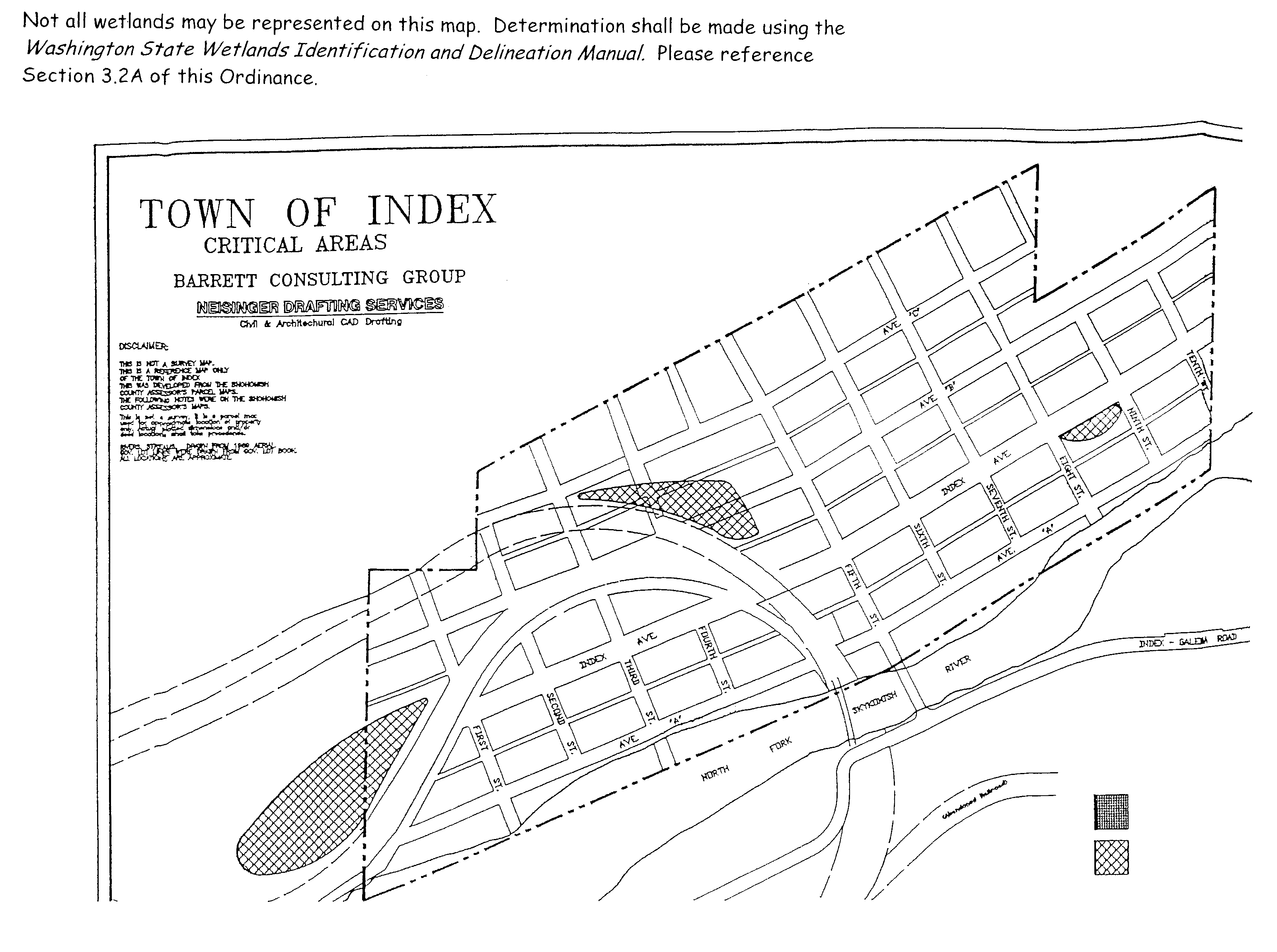
Appendix C
Buffer Zone Map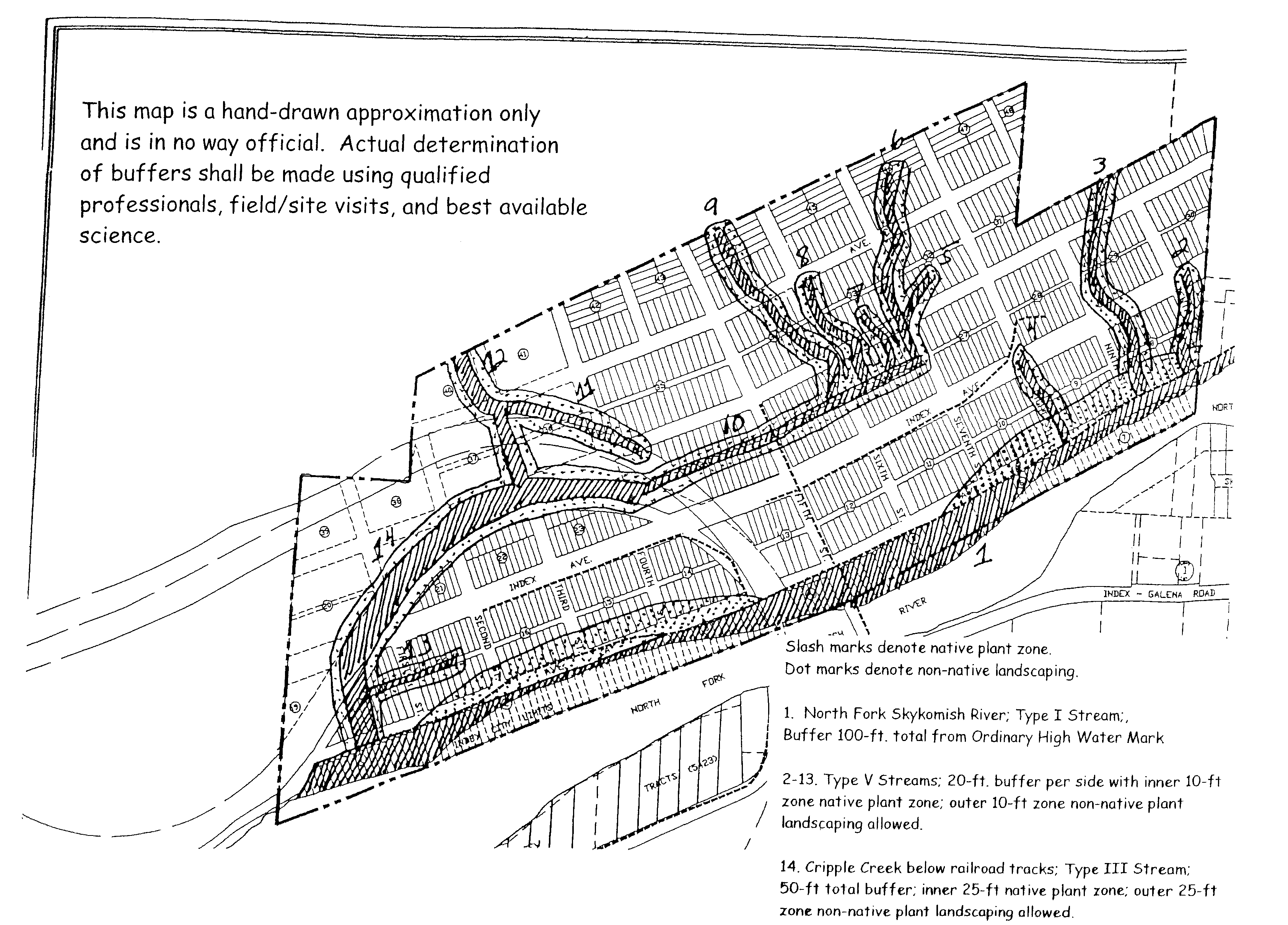
Appendix D Native Vegetation for Buffers, Revegetation and Mitigation Projects
The following list of vegetation native to the North Cascades and/or Puget Sound area should be considered a partial list, or starting point. For other suggestions please contact your local library or qualified professionals.
Conifer Trees
Douglas Fir (Pseudotsuga menziesii)
Western Hemlock (Tsuga heterophylla)
Mountain Hemlock (Tsuga mertensiana)
Grand Fir (Abiea amabilis)
Subalpine Fir (Abies lasiocarpa)
Noble Fir (Abies procera)
Lodgepole Pine (Pinus contorta)
Western Red Cedar (Thuja plicata)
Alaska Yellow Cedar (Chamaecyparis nootkatensis)
Pacific Yew (Taxus brevifolia)
Sitka Spruce (Picea sitchensis)
Deciduous Trees
Black Cottonwood (Populus trichocarpa)
Willows (Salix species)
Red Alder (Alnus rubra)
Bigleaf Maple (Acer macrophyllum)
Vine Maple (Acer circinatum)
Douglas Maple (Acer douglasii)
Pacific Dogwood (Cornus nuttalii)
Shrubs
Creek Dogwood (Cornus stolonifera)
Pacific Ninebark (Physocarpus capitatus)
Black Twinberry (Lonicera involucrata)
Salmonberry (Rubus spectabilis)
Thimbleberry (Rubus parviflorus)
Stink Currant (Ribes bracteosum)
Red Flowering Currant (Ribes sanguinium)
Serviceberry (Amalanchier alnifolia)
Snowberry (Symphorocarpus alba)
Salal (Gaultheria shallon)
Oregon Grape (Berberis nervosa)
Twinflower (Linnaea borealis)
Huckleberries (Vaccinium species)
Fool’s Huckleberry (Menziesia ferruginia)
Copperbush (Cladothamnus pyrolifloriae)
Common Juniper (Juniperis communis)
Davidson’s Penstemon (Penstemon davidsoni)
Sword Fern (Polystichum munitum)
Deer Fern (Blechnum spicant)
Section 16.16.080 does not apply to geologically hazardous areas. Use authorized within geologically hazardous areas and their buffers are limited to those identified in Section 16.16.370.
Section 16.16.300 is intended to summarize the water classification adopted into WAC 222-16-030. WAC 222-16-030 shall supersede any conflicting provision in Section 16.16.300.