5. LAND USE
The Everest Neighborhood contains a mix of low to medium-density residential neighborhoods, light industrial technology, retail and office land uses. Portions of the Everest light industrial technology and office areas are located within the boundaries of the Greater Downtown Urban Center (see Land Use Element Figure LU-2).
Lower-density residential development is located in the central and eastern portions of the Everest Neighborhood, whereas higher-density residential development is concentrated toward the south and northeast. Light industrial and office development is clustered in the western part of the neighborhood and extends northeast along the Cross Kirkland Corridor.
Two prominent commercial landmarks are the Sierra Building at the north end of the neighborhood and the large high technology corporate campus located in the industrial/office area west of 6th Street South. The Houghton Everest Neighborhood Commercial area along NE 68th Street is a major gathering place for the neighborhood.
Specific land use designations for the Everest Neighborhood are illustrated in Figure EV-3. These designations are based on several factors including the natural environment, existing land uses, proximity to shops and services, access to transit, proximity to the freeway, traffic patterns, and other relevant concerns.
Residential
Policy EV-5:
Lower-density residential areas may integrate a variety of smaller compact housing options over time.
Everest’s lower-density residential areas contain many representatives of older housing stock from Kirkland’s early years as a city. Increasingly these older, smaller homes are being replaced with newer, larger housing styles. As infill development continues throughout the neighborhood, incorporating smaller housing options for people at a more moderate cost is encouraged, such as accessory dwelling units, duplexes, triplexes, and cottages as allowed in all lower-density areas by the Zoning Code.
Policy EV-6:
Lower-density residential designations on the hillside east of Everest Park, including missing middle housing types, should be maintained as shown on the Land Use and Zoning Maps.
The hillside in the eastern portion of the Everest Neighborhood contains a low-density residential land use designation. Vehicular access is limited, and perhaps for this reason, there is a quiet and secluded character to this residential area. Due to the constraints of limited access and critical areas of geologically hazardous slopes and water courses, the eastern portion of the Everest Neighborhood should retain its low-density residential classification south of Alexander Avenue and north of Alexander Avenue and south of Everest Park. Development should be subject to critical area and tree retention regulations contained in the Zoning Code.
Policy EV-7:
Medium-density residential development is permitted where indicated and is not to spread further east.
Medium-density residential is appropriate as a transition and to lessen the visual impacts between lower-density residential to the east and industrial land use and CKC on the west. Other considerations for this medium-density designation are topography, irregular shaped lots, and circulation is challenging and limited.
Future multifamily development in this area should not extend further to the east than existing multifamily development (see Figure EV-3). Medium-density development is appropriate for the majority of the land east of Cedar Street. The existing apartment site located at the northeast corner of the intersection of Cedar Street and Kirkland Avenue is appropriate for slightly higher residential density, due to lack of environmental constraints, direct access onto Kirkland Avenue, proximity to other lands of similar density (across Cedar Street), and the ability to physically accommodate additional development with a minimum of impacts to surrounding uses.
Policy EV-8:
Land north of Kirkland Avenue and east of the multifamily development adjoining Cedar Street is appropriate for medium-density development if designed to minimize impacts to slopes.
This area contains steep sloped ravine with surface water and soils susceptible to high landslides. Development should mitigate potential impacts to the ravine with geotechnical recommendations and design approaches such as coordinated layout of parcels, aggregating parcels, clustering of structures, reduced building footprints, maximizing tree and vegetation retention, and consolidation of shared vehicle and pedestrian access from Kirkland Avenue.
Policy EV-9:
Medium-density development along NE 68th Street and east of 6th Street South is to be continued.
The southern portion of the Everest Neighborhood is impacted by the existence of a freeway interchange and by heavy traffic volumes along NE 68th Street and 6th Street South. South of 9th Avenue South most land is developed with condominiums or apartments. This area is in close proximity to shops, services and transit. To encourage increasing affordable housing in this area, future redevelopment of multifamily uses in this area is encouraged to be built to maximum permitted densities.
Commercial
Policy EV-10:
A plan for future development of the Houghton/Everest Neighborhood Center should help create a mixed-use neighborhood center that provides goods and services to the local community and should be coordinated with the Central Houghton Neighborhood.
The Land Use Element designates the Houghton/Everest Neighborhood Center as a commercial and mixed-use area. It spans the north and south sides of NE 68th Street and includes property on the east side of 6th Street and 108th Avenue NE. The Houghton/Everest Neighborhood Center located on the north side of NE 68th Street is located within the Everest Neighborhood. The Neighborhood Center should serve the needs for goods and services of the local community. Uses within the Neighborhood Center may include retail, restaurants, office, service businesses and housing, with grocery and drug stores a high priority anchor to serve the everyday needs of the community. Housing provides the opportunity for people to live close to shops, services, employment, transit and the Cross Kirkland Corridor. Redevelopment plans for properties on the west side of 6th Street South/108th Avenue should promote a coordinated strategy for redevelopment of the Neighborhood Center on both sides of NE 68th Street.
The following principles should be incorporated into development plans and standards for the area:
• Preserve and enhance neighborhood-serving retail, especially grocery stores;
• Promote a mix of complementary uses;
• Promote high quality design by establishing building, site and pedestrian design standards and guidelines;
• Foster walkable neighborhoods and increased transit service;
• Integrate affordable housing where possible;
• Create gathering places and opportunities for social interaction.
Properties along 6th Street South, 108th Avenue NE and NE 68th Street are impacted by heavy traffic volumes. Future redevelopment and transportation improvements should incorporate the recommendations from the 6th Street Corridor Transportation Study. A new east/west connection from 106th Avenue NE through the Neighborhood Center should also be considered.
Properties to the east of 6th Street South should be encouraged to develop together with joint access off of 6th Street South.
Building heights should be allowed to step up to three stories if certain retail uses that primarily serve the neighborhood are provided. Careful attention should be given through the design review process to pedestrian orientation, building modulation, upper story setbacks, and use of materials to reduce the appearance of bulk and mass.
With regard to building height, an additional two stories (five stories maximum) may be authorized by a Master Plan, which is approved by the City Council after full legislative process with opportunities for public participation. The Master Plan should include the following:
• Provision for traffic mitigation as recommended in the 6th Street Corridor Transportation Study;
• Consolidation of the property on the northwest corner of NE 68th Street and 6th Street South and property or properties west of the corner property;
• Compliance with the principles outlined above for development in this commercial area; and
• A circulation plan and a driveway consolidation plan for the Everest portion of the Houghton/Everest Neighborhood Center north of NE 68th Street.
The Zoning Map designates this area on the north side of NE 68th Street as HENC 1 and HENC 3 zone. See the Zoning Code for allowed uses and development regulations, and the Design Guidelines for Pedestrian Oriented Development, which provide the design guidelines for future redevelopment of the HENC zones.
Policy EV-11:
Promote land uses west of 6th Street South and along the Cross Kirkland Corridor that minimize neighborhood impacts and enhance the multi-use corridor.
Light industrial and office uses exist and should continue to be permitted on the west side of 6th Street South and to the northeast along the Cross Kirkland Corridor (CKC) to Kirkland Avenue (see Figure EV-3). In this area there is a trend away from light industrial uses to office and other uses. As redevelopment opportunities adjoining the Corridor arise, connections to the trail and innovative uses that may benefit from pedestrian and bicycle trail users should be encouraged including small retail, eating, drinking establishments or recreational uses. See Land Use Element for Cross Kirkland Corridor Policies, and the CKC Master Plan and Zoning Code for development standards for uses adjoining the CKC.
Further development in the industrial zones, however, should be subject to the following standards in order to minimize impacts on residential uses and the existing character of the area:
(1) Industrial activities should not generate heavy volumes of truck traffic along residential streets. Truck frequency, noise, and hazard can constitute a serious nuisance for residential areas. Therefore, the expansion of existing industrial uses should be permitted only if traffic impacts on residential areas are mitigated.
(2) The visibility of industrial operations (including manufacturing, processing, storage, and shipping/receiving) from nearby residential development should be limited. Such industrial operations should be oriented away from residential uses and should be visually screened or completely enclosed within structures.
(3) The height of structures should not exceed 35 feet.
(4) Hours of operation should be considered on a case-by-case basis depending on the potential impact on the neighborhood. Industrial activities during evening or weekend hours may be permitted if they are not disruptive to nearby residential areas.
(5) Adequate fencing, landscaping, and/or other visual screening should be provided between residential uses and adjacent industrial developments and their related parking.
Policy EV-12:
Professional office and medium-density residential uses permitted east of 6th Street South.
Land along the east side of 6th Street South north of the HENC area is suitable for a variety of professional office and medium-density residential uses as a transition to the low-density residential area to the east and industrial-high technology area on the west side of 6th Street South. Such development should be oriented toward and take access only from 6th Street South. The easterly extension of such development also should be strictly limited to the midblock line between 6th and 7th Streets South.
Policy EV-13:
Provide effective transitions between lower-density residential neighborhoods and higher-density residential and commercial uses to minimize impacts between uses.
Along transition areas between uses, higher density and commercial development should minimize impacts on adjacent lower-density residential neighborhoods using means such as landscape buffers, tree retention, high-quality design elements, adequate parking, and low lighting and noise levels.
Policy EV-14:
Support transit-oriented development around the I-405/NE 85th Street Bus Rapid Transit (BRT/Stride) Station.
Land use changes and supportive infrastructure improvements in the southwest quadrant of the interchange should be pursued to locate additional jobs near the BRT/Stride Station and achieve the transit-oriented development goals of the future Station Area Plan.
Policy EV-15:
For portions of the Everest Neighborhood located within the Greater Downtown Urban Center and pending Regional Center, provide housing, employment, open space amenities, and multi-modal connections that support the vision and policies of the Greater Downtown Urban Center/Regional Center.
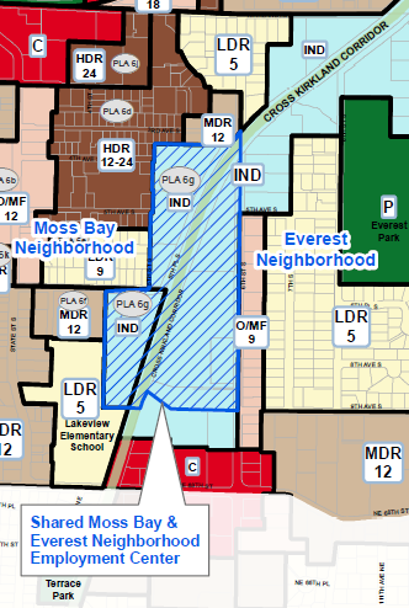
Portions of the Everest Neighborhood are included within boundaries of the Greater Downtown Urban Center designated by King County Countywide Planning Policies. For purposes of the pending Regional Center designation by Puget Sound Regional Council, the shared Moss Bay and Everest Neighborhood employment center is a subarea that contains a large corporate technology campus that spans both the Moss Bay and Everest neighborhoods and is proposed for inclusion in the Regional Center as a way to recognize the significance of the employment and transportation needs of this subarea (see map below and Land Use Element Figure LU-2). Because of the close proximity to the Urban Center/Regional Center, the shared employment center within the Moss Bay and Everest neighborhoods can optimize employment and housing opportunities, open space and recreational amenities within walking distance, and provide multi-modal connections to and from the area via the CKC, transit, the NE 85th Street BRT/Stride Station.