


7. Transportation and Mobility
The vision for the Finn Hill Neighborhood transportation system is to provide safe, comfortable, and efficient circulation for people who walk, ride bicycles, drive cars and ride transit within the neighborhood. During the neighborhood plan public participation process, residents emphasized the importance of improving the existing trails and bike network, particularly the connectivity to key destinations (schools, shopping center, etc.). Other comments expressed are covered in the Citywide Transportation Element, such as: implement Complete Streets, low impact development techniques along streets to handle surface water, coordinate land use with transportation and transit policies, and prioritize sidewalks on school walk routes.
The transportation and mobility goals in this chapter are intended to make public transit, walking and/or riding a bicycle an attractive option for most residents in the neighborhood. Investments in the neighborhood should also be prioritized in order to support these options. The City’s Transportation Element will guide the implementation of these goals as well as the Capital Improvement Plan (CIP). References to transportation policies in the Transportation Element are included throughout this chapter.
This chapter addresses primarily circulation in the public right-of-way. Recreational trails and the Green Corridor Loop are discussed in Section 6, Parks and Open Space.
Sidewalks, Intersections, and Pedestrian Mobility throughout the Finn Hill Neighborhood
Throughout the neighborhood plan public outreach process, Finn Hill residents expressed concerns regarding the lack of safe sidewalk connections to important neighborhood assets, including: schools, parks, transit stops, and other public destinations. The 2016 status of sidewalk completion in Finn Hill is shown in Figure FH-7.1.
As the neighborhood grows over time, sidewalks should be brought up to City standards and connections to neighborhood assets should be prioritized. Residents identified a network of sidewalks and intersections that they felt are a high priority for improvement in the neighborhood (Figure FH-7.2).
Goal FH-12: Form a safe multimodal network of sidewalks, trails, bikeways and crosswalks where walking and cycling are the first choice for many trips.
Goal FH-13: Create and improve sidewalk connections to schools and destinations throughout the neighborhood.
Policy FH-13.1: Establish safe and comfortable pedestrian crossings on major arterials.
Finn Hill residents are concerned about the safety of new and existing pedestrian facilities throughout the neighborhood. Residents support installing crosswalks, signage, safety refuge islands, signals, flashing lights and flags at intersections; improved lighting; sidewalks along major arterials, separation travel modes (e.g., raised curbs) where other forms of nonmotorized and motorized transportation may cause safety concerns for pedestrians and addressing sight distance issues.
Policy FH-13.2: Prioritize designated school walk routes for pedestrian improvements.
Citywide priorities encourage children to walk to school and to complete a sidewalk network on all school walk routes. Consistent with this Citywide policy, completing a network of sidewalk systems and other public improvements on school walk routes within the neighborhood is desired.
Policy FH-13.3: Prioritize pedestrian pathways to neighborhood destinations (parks, public transit, and commercial areas) to improve and encourage pedestrian connections to amenities.
Finn Hill residents identified a number of critical neighborhood pedestrian connections, such as connections between 84th Avenue and the Hermosa Vista development and Goat Hill area, and improving pedestrian access to parks, public transit, commercial areas and the shoreline (See Figure FH-7.2). Removing barriers to pedestrian pathways by providing connections through cul-de-sacs and dead-end streets is also desired.
Policy FH-13.4: Along streets, provide pedestrian amenities such as crosswalks, sidewalks, street trees, lighting and street furniture to encourage walking, provide informal gathering places and enhance the pedestrian experience.
Providing the pedestrian amenities suggested in this policy make walking more enjoyable and safe, especially around destinations such as commercial areas, parks and schools.
Vehicular Circulation
Figure FH-7.3 shows the major vehicular circulation routes throughout the Finn Hill Neighborhood and street classifications. As part of the neighborhood plan outreach process, Finn Hill residents are concerned about traffic congestion in their neighborhood, particularly as there are a limited number of arterials and entry points into the neighborhood. Two key concerns regarding vehicular traffic emerged from community outreach: congestion and safety. At the same time there are areas of Finn Hill with underdeveloped streets. Improvements to these are necessary to enhance vehicular circulation and emergency access.
Commuter traffic on Juanita Drive is a major concern as it is the main north-south route through the neighborhood and a key entry point to the neighborhood. Ongoing development in Finn Hill and surrounding areas is intensifying commute congestion issues. To address these issues, residents would like to focus policies toward encouraging neighborhood trips with more efficient alternative modes of transportation. Through the Neighborhood Traffic Control program techniques can be implemented to minimize commuter cut-through traffic on internal neighborhood streets.
Goal FH-14: Implement a more efficient, safe and sustainable transportation system.
Policy FH-14.1: Prioritize improvements which encourage transit use, carpools, bicycle use and more sustainable forms of transportation which minimize our impact on the environment.
This policy reflects resident’s priorities to provide a multimodal transportation system over time in Finn Hill.
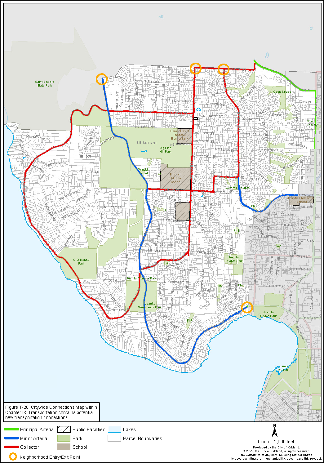
Figure FH-7.3: Finn Hill Street Classifications
Policy FH-14.2: Conduct studies to determine the design standards for the following streets:
• Residential streets within the Holmes Point Overlay area
• Holmes Point Drive corridor
• NE 131st Way/90th Avenue NE corridor
Finn Hill residents would like the character of the neighborhood to influence the design of pedestrian and street facilities that are built. For example, some residents feel sidewalks may not be appropriate for all areas and that “walking lanes” may be more appropriate for areas of the neighborhood with a more rural character. Developing the design standards for the streets should be created through a public involvement process. The standards should consider alternative designs for streets consistent with the City’s Complete Streets Ordinance, such as the type of sidewalks, whether on-street parking is allowed, lighting, vegetation, pedestrian amenities, topographic or critical area constraints, tree retention, neighborhood character, all while providing emergency vehicular access. The presence of physical constraints such as steep topography, critical areas or to retain trees in a particular location may also require modification to city standards for right-of-way improvements.
Policy FH-14.3: Minimize direct access to Juanita Drive to enhance safety and efficiency of circulation.
Because of topographic constraints and the speed of vehicular traffic, access to Juanita Drive should be limited. If driveways to Juanita Drive must be provided, they should be separated by at least 300 feet wherever possible. New driveways should be located so that future development can meet this standard and/or use a shared driveway. Access easements to allow for shared access to Juanita Drive and/or interior connections to side streets should be provided. As access to side streets becomes available, driveways to Juanita Drive should be closed where possible.
Policy FH-14.4: Discourage regional and bypass traffic in residential neighborhoods.
Residents’ safety concerns focused on problems with speeding and ensuring that neighborhood streets are safe for multiple forms of transportation. Traffic calming strategies could be developed to discourage regional traffic from using residential neighborhood streets.
Policy FH-14.5: Minimize cut-through traffic and reduce speeding through residential neighborhoods in coordination with City’s Neighborhood Traffic Control program.
Evaluate traffic patterns and volumes in the neighborhood to minimize cut-through traffic and speeding in order to support the existing Neighborhood Traffic Control Program.
Bicycle Facilities
Bicycle-supportive facilities provide recreational opportunities and alternative transportation options. Desired improvements for bicyclists include providing protected bike facilities on arterials and collectors, as well as providing safe crossings on Juanita Drive. Finn Hill residents are interested in bicycle routes that connect to parks and other key destinations within the neighborhood and region (See Figure FH-7.4).
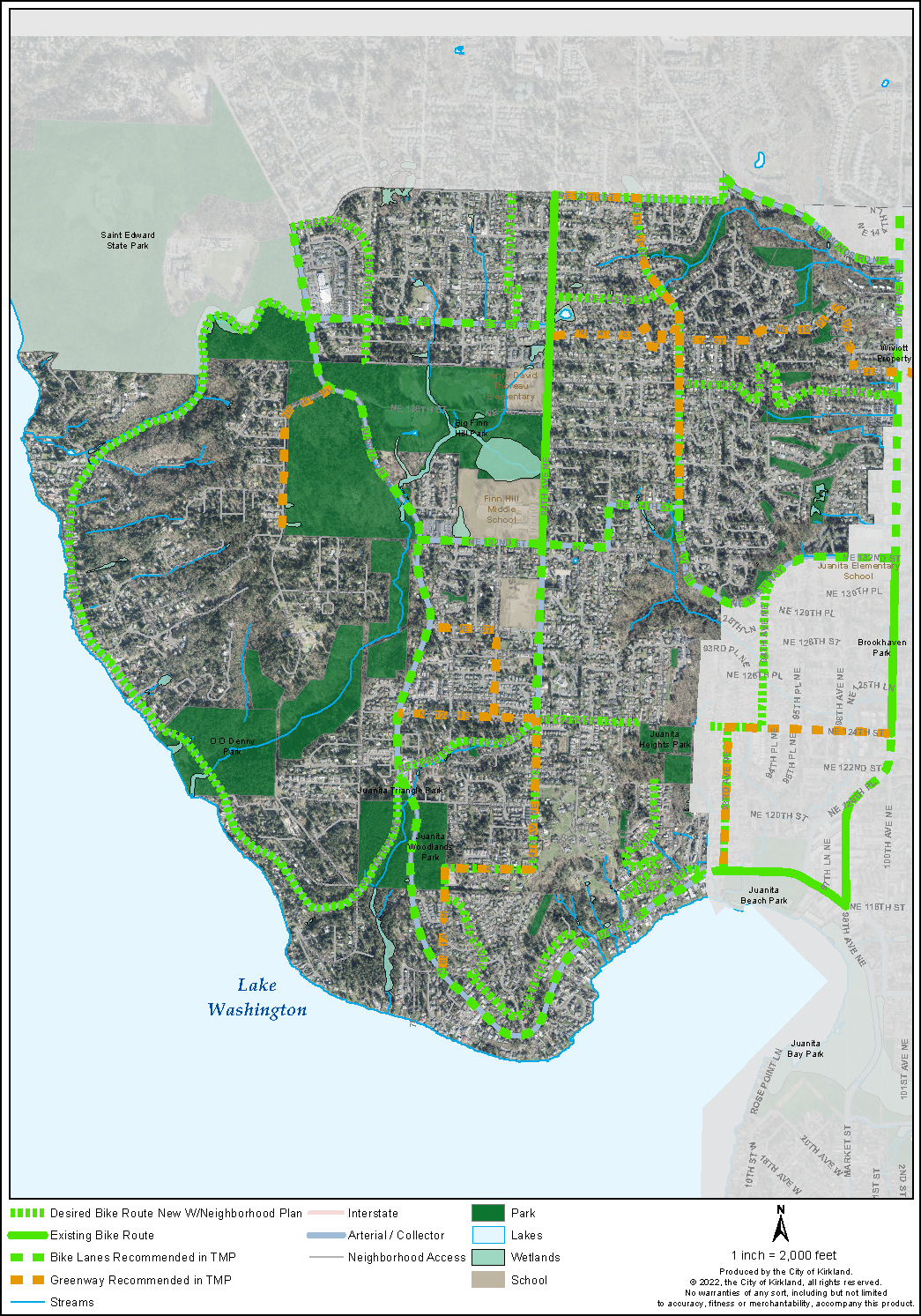
Figure FH-7.4: Finn Hill Priority Bike Routes
Goal FH-15: Expand safe and comfortable bicycle connections throughout the neighborhood and to surrounding areas.
Safety, user friendliness, and connectivity are key concerns that residents have regarding Finn Hill’s bicycle routes and facilities. Safe bicycle access within and through the neighborhood is a high priority. Approaches to address safety include creating separated bicycle lanes (including painted buffers and physical separation) and implementing neighborhood greenways on residential streets that are connected to bicycle facilities on major arterials. The implementation of these policies can be monitored under the performance measures and action items in the Transportation Element of the Comprehensive Plan.
Policy FH-15.1: Improve bicycle connections to destinations within the neighborhood (parks, transit facilities, schools, and shopping areas) and to trail systems outside of Finn Hill.
Similar to providing pedestrian trails and sidewalks discussed above, a priority for the neighborhood is to provide a bicycle system to be able to travel throughout the neighborhood to key destinations. Providing safe bicycle and intersection facilities to allow children and parents to travel to and from school, reducing vehicle traffic around schools and neighborhood, is a high priority.
Policy FH-15.2: Establish neighborhood greenways throughout the neighborhood.
Neighborhood greenways are designated residential streets, generally off main arterials, with low volumes of vehicular traffic and low speeds, where people who walk and bike are given priority.
Policy FH-15.3: Determine the needs of commuter and recreational bike rider groups.
The Finn Hill residents have identified two different types of bicycle routes and facilities: commuter and recreational bicycle facilities. These facilities may require specific bicycle amenities (e.g., repair stations, directional signs) along existing and proposed routes to support ridership.
Residents would like to improve the connectivity of Finn Hill’s bicycle routes within the neighborhood and to the broader trail network. Bicycle facilities should connect to parks and amenities within Finn Hill. Bike facilities should also connect to other regional trail systems outside of Finn Hill (Lake Washington Loop Trail, Burke Gilman, Cross Kirkland Corridor, and Sammamish River Trail). Incorporating the pedestrian and bicycle connections and facility needs for Finn Hill in the Active Transportation Plan is a priority. The City should explore ways to expedite improvements.
Policy FH-15.4: Explore public pedestrian and bicycle easements across properties to complete the trail system.
During the development review process, there may be opportunities to acquire public access easements across private property to provide pedestrian and bike trail connections to pedestrian and bicycle networks.
Transit Service
The Finn Hill Neighborhood is served by public transit in the northwest corner via King County Metro bus route 234. Finn Hill residents expressed interest in a more extensive neighborhood transit system (See Figure FH-7.5). Additional transit options may benefit the community by assisting the aging population, increasing connectivity to transit hubs, and providing alternative transit services for commuters.
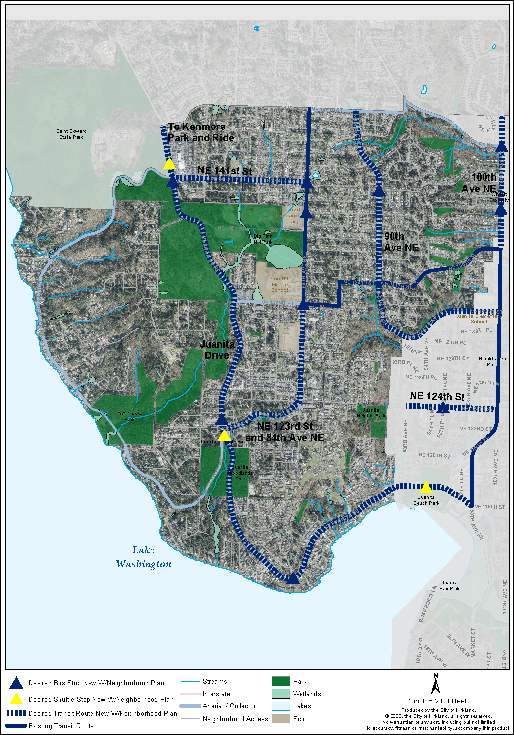
Figure FH-7.5: Finn Hill Existing and Priority Public Transit System
The current low-density land use and development pattern in the Finn Hill Neighborhood makes it difficult to sustain additional fixed-route transit service because the ridership is lower than many other transit routes operated by King County Metro Transit. The City of Kirkland will continue to advocate for better transit solutions for the neighborhood. This includes new approaches to transit that do not rely on fixed bus routes, such as King County Metro’s Neighborhood Connections program which provides small-scale flexible transit programs.
Goal FH-16: Prioritize investments in the neighborhood toward increasing public transit options.
Considering the low-density land use pattern, the City should support alternative transit options. Pedestrian and bicycle networks linked to neighborhood destinations such as commercial areas, parks and schools support transit use. Providing transit amenities, such as frequent service, inviting bus shelters, and bus stops in key safe neighborhood activity areas with easy pedestrian access, encourages more transit use.
Policy FH-16.1: Work with transit agencies and other providers to connect transit within Finn Hill’s two commercial areas to surrounding transit centers outside the neighborhood.
The City and King County Metro should prioritize and coordinate infrastructure and needed density to support increased transit service to the two commercial areas in Finn Hill. The commercial areas serve as focal points for the neighborhood providing goods and services, are surrounded by higher density residential housing and nearby parks and located along a major north/south corridor.
Policy FH-16.2: Explore alternative modes of transportation or research transit service options suitable for lower density areas of the neighborhood (e.g., shuttles, car shares, vanpools).
In lower density areas not sufficient to support transit service, alternative modes of transit service, ride shares, or shuttles should be explored to link people together with commercial areas, schools, and parks.