


Chapter 22.800
APPENDICES
Contents:
Appendix A Shoreline Environment Designations Map.
Appendix B Mitigation Options to Achieve No Net Loss for New or Re-development Activities.
Appendix C Shoreline Restoration Plan.
Appendix D Channel Migration Zone Maps.
Appendix E Critical Areas Regulations Incorporated by Reference.
Appendix F List of Shoreline Water Bodies.
Appendix A
SHORELINE ENVIRONMENT DESIGNATIONS MAP
Appendix A is on file and may be reviewed in the office of the clerk of the board of commissioners.
(Ord. 598 (2021) § 4 (Appx. 1), 2021)
Appendix B
MITIGATION OPTIONS TO ACHIEVE NO NET LOSS FOR NEW OR RE-DEVELOPMENT ACTIVITIES
B.1 General Mitigation Standards
A. After mitigation sequencing is applied in accordance with Section 22.400.110(A), compensatory mitigation selection shall be guided by this appendix.
B. Some projects may result in multiple types of impacts to shoreline ecological functions, each of which may require compensatory mitigation.
C. Mitigation is not required outside of the Standard Buffer. Applicable critical area, stormwater, and site planning sequencing standards shall still apply. See Figure B.1-1.
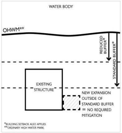
Figure B.1-1. Clearing outside of Standard Buffer
D. Unless otherwise specified during the agency review process, mitigation for new or re-development activity shall be at a 1:1 ratio.
E. Where a site-specific Shoreline Mitigation Plan (see Section 22.700.140) can demonstrate no net loss of shoreline ecological functions, alternate mitigation ratios may be applied.
F. Shoreline Mitigation Plans (see Section 22.700.140) shall utilize applicable information from the Kitsap County Shoreline Inventory and Characterization report, as supplemented with site-specific data.
G. Mitigation planting or other mitigation options shall occur adjacent and parallel to the OHWM of the shoreline as a first preference. Depending on site conditions, mitigation may be allowed away from the shoreline edge, if the actions are replacing in-kind functions and would achieve greater ecological benefit. Where demonstrated to be feasible through mitigation sequencing, this may include mitigation on adjoining upland parcels under the same ownership as the shoreline parcel requiring mitigation.
H. Based on required mitigation and mitigation sequencing in accordance with this Program, a combination of mitigation options may be utilized to achieve no net loss of shoreline ecological functions. In-kind measures are preferred over out-of-kind measures. See applicable sections below for preferred order of compensatory mitigation.
I. If public access is included in the development, mitigation may be reduced by up to one half, provided all other applicable provisions are met. Where this option is utilized to mitigate for impacts to ecological functions, public access projects shall incorporate measures to improve ecological functions to the extent feasible at the project location.
B.2 Mitigation Standards for Specific Development Activities
A. Vegetation Clearing
|
Existing Vegetation Being Removed |
Mitigation Requirement Between the Standard and Reduced Standard Buffers |
Mitigation Requirement Waterward of the Reduced Standard Buffer |
|---|---|---|
|
Grass/Lawn |
Replace 1/2 of the equivalent of the cleared area with native vegetation (see Figure B.2-1a) |
Replace the equivalent of the cleared area with native vegetation (see Figure B.2-1d) |
|
Non-Native Landscaping (groundcover other than lawn, shrubs, trees) |
Replace the equivalent of the cleared area with native vegetation (see Figure B.2-1b) |
Replace 2 times the equivalent of the cleared area with native vegetation |
|
Native Vegetation (groundcover, shrubs, trees) |
Replace 2 times the equivalent of the cleared area with native vegetation (see Figure B.2-1c) |
Replace 4 times the equivalent of the cleared area with native vegetation |
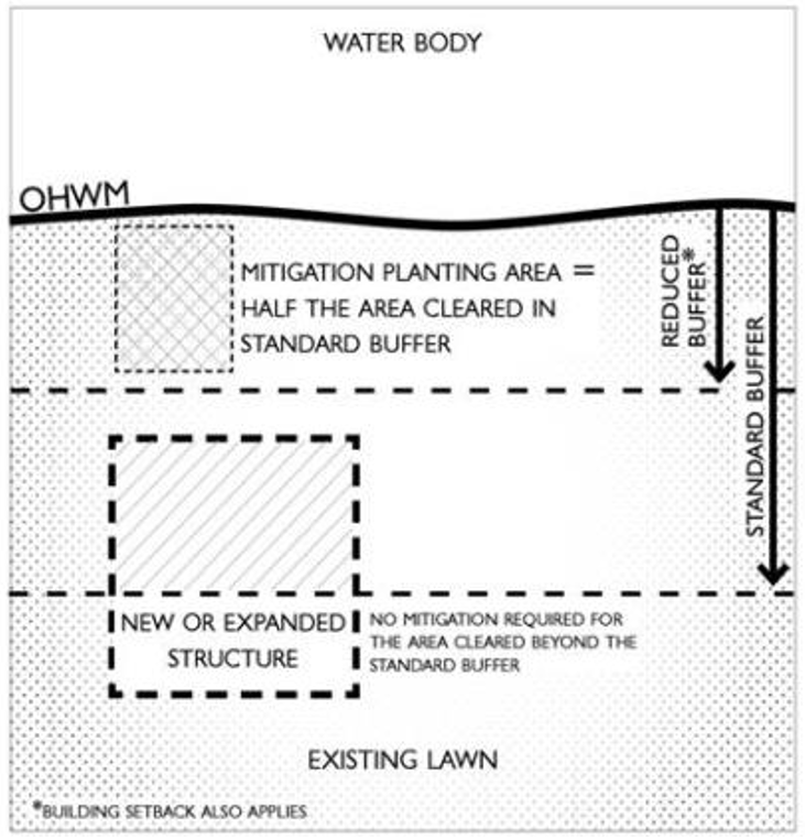
Figure B.2-1a. Mitigation for clearing existing lawn within the Standard Buffer
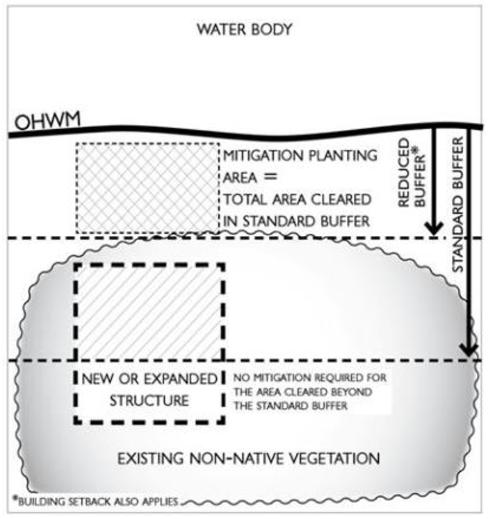
Figure B.2-1b. Mitigation for clearing non-native vegetation within the Standard Buffer
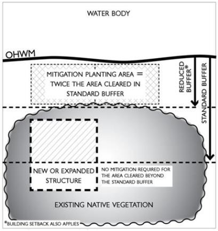
Figure B.2-1c. Mitigation for clearing native vegetation within the Standard Buffer
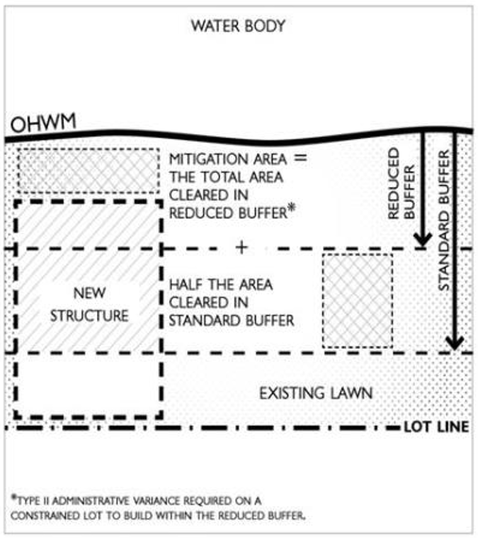
Figure B.2-1d. Mitigation for clearing existing lawn within the Standard and Reduced Buffers
B. Alternative standards for vegetation clearing. Where it can be demonstrated that intact native vegetation outside of the required buffer provides greater ecological function than previously cleared or developed areas within the buffer, permanent retention of the intact native vegetation outside of the buffer may be allowed as an alternative, consistent with the vegetation replacement ratios listed above. Such areas shall be recorded under a notice to title, and marked with standard buffer signage.
C. Alternative standards for impervious surface installation:
1. Decks and semi-pervious surfaces: for installation of pervious or semi-pervious surfaces such as non-solid surface decks in place of existing lawn or other non-native vegetation, pervious area may be subtracted from the above mitigation requirements.
2. Rain garden option: for new or expanded impervious surface that replaces grass, lawn or non-native landscaping, rain garden installation may be utilized in lieu of the above replanting specifications. Rain gardens shall generally be 50-80% of the new impervious surface size, depending on soil type. Rain gardens may not be appropriate in all locations due to soil type or slope. Staff shall be consulted prior to selecting this option. For additional guidance, see Rain Garden Handbook for Western Washington Homeowners, Washington State University Extension, 2007, now or as hereafter amended. http://www.pierce.wsu.edu/Water_Quality/LID See Figure B.2-2.
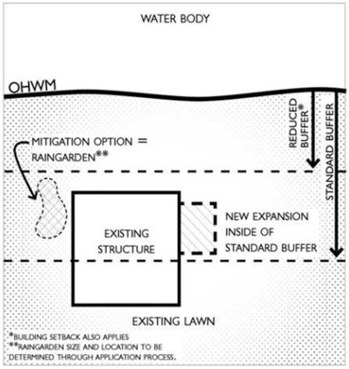
Figure B.2-2. Mitigation using raingarden option for clearing in Standard Buffer.
3. Impervious Surface Removal Credit: removal of impervious surface of an equivalent or greater area and replacement with vegetation may be utilized for mitigation credit at a 1:1 ratio, so long as the existing impervious surface to be removed is within the Standard or Reduced Standard Buffer. When such removal occurs outside of the Standard Buffer, a 0.5:1 ratio will be applied. See Figure B.2-3.
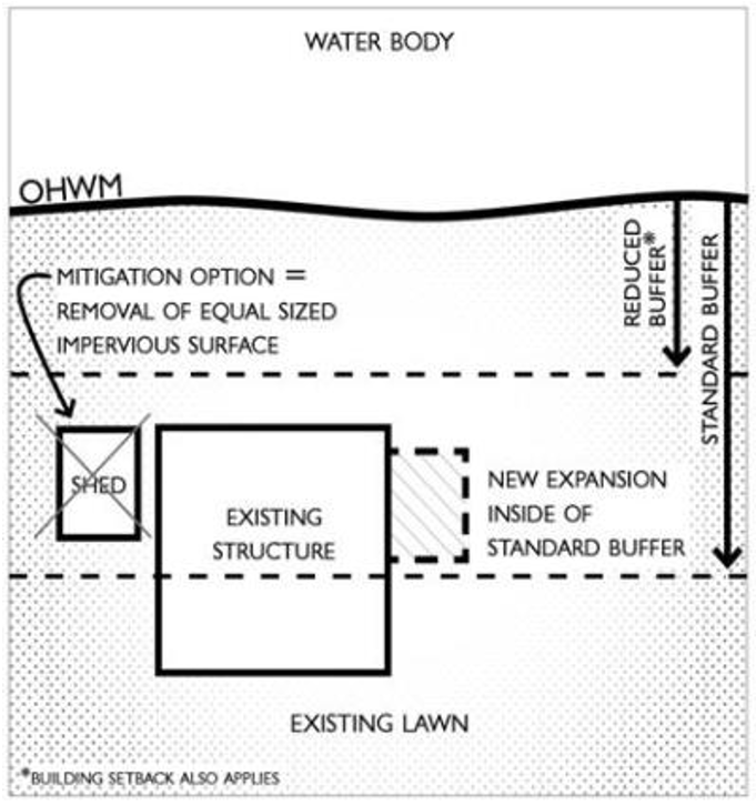
Figure B.2-3. Mitigation using removal of impervious surface option for clearing in Standard Buffer
4. Impervious surface installation in areas lacking vegetation: where new impervious surfaces are installed on surfaces generally lacking vegetation, such as existing parking or driving surfaces, mitigation may generally be achieved by implementing appropriate stormwater treatment methods for new impervious surface areas.
B.3 New and Replacement Shoreline Armoring or Barrier Structures (in order of preference)
A. If new, removal of another barrier structure at a 1:1 ratio (length), or other opportunities identified in the Kitsap County Shoreline Inventory and Characterization Report.
B. If replacement exceeds 50% of existing structure, use soft or hybrid alternative(s) such as adding logs or stumps.
C. For new or replacement:
1. Remove fill and move armoring landward.
2. Add a “pocket beach” to the design, where appropriate based on shoreline functions.
3. Add overhanging vegetation along the bulkhead edge or other portion of shoreline currently not providing such features, when other options are not available.
4. Add beach nourishment, where determined appropriate in consultation with agencies with jurisdiction and affected tribes.
B.4 New and Replacement Overwater Structures (in order of preference)
A. For new development, remove any additional legally established existing over-water or in-water structures that are not the subject of the application and are not otherwise required to be removed because they are illegal or are the subject of a required clean-up effort.
B. For new or replacement, add site appropriate habitat features in consultation with agencies with jurisdiction.
C. For dock additions, partial dock replacements, or other modifications, replace areas of existing solid over-water cover with grated material or use grating on those altered portions of docks if they are not otherwise required to be grated.
D. Plant native vegetation along the shoreline immediately landward of the OHWM consisting of trees and/or shrubs native to Kitsap County and typically found in undisturbed areas adjacent to the subject water body. When shoreline plantings are the only mitigation option for a given overwater proposal, the new or expanded footprint must be compensated for at a 1:1 planting area ratio with required trees planted on 10-foot centers and/or shrubs planted on 5-foot centers. Native groundcover can be supplemental to the planted shoreline area, but does not count toward the total square footage requirement.
E. Remove or ecologically improve hardened shoreline, including existing launch ramps or hard structural shoreline stabilization. Improvements may consist of softening the face and toe of the stabilization with soil, gravel and/or cobbles and incorporating vegetation or large woody debris.
F. Remove man-made debris waterward of the OHWM, such as car bodies, oil drums, concrete or asphalt debris, remnant docks, or other material detrimental to ecological functions and ecosystem-wide processes.
G. Place large woody debris if consistent with local, state and/or federal regulations.
H. Participate in an approved mitigation banking or in-lieu-fee program, after consideration of feasible on-site options.
B.5 Alternative Mitigation Options
The following alternative mitigation options may be utilized where appropriate to achieve no net loss of ecological functions, either in combination with or in lieu of the options provided in Sections B.2 – B.4.
A. Transfer of Development Rights, if applicable (KCC 17.580)
B. Off site, in-lieu fee (if available). For Hood Canal, the Hood Canal Coordinating Council In-Lieu Fee program shall be utilized.
C. Documented restoration activities which have occurred on the property after adoption of this Program and within five years of shoreline development or redevelopment, in accordance with the Shoreline Restoration Plan (Appendix C) of this Program, may be considered for use as mitigation. Mitigation credit for prior activities shall be determined upon application for the proposal that requires mitigation.
D. Other options from Chapter 4 of the Kitsap County Shoreline Inventory and Characterization report and Appendix C of this Program, where demonstrated that such options shall achieve no net loss of shoreline ecological functions for the proposed development activity. Such options may not be utilized if they have been specifically identified for use of public restoration funds, except where approved through a public-private partnership.
E. Other options commensurate with the level of proposed impact, as may be identified approved guidance principles for local jurisdictions that provide options to achieve no net loss of shoreline ecological functions.
(Ord. 598 (2021) § 4 (Appx. 1), 2021)
Appendix C
SHORELINE RESTORATION PLAN
Appendix C is on file and may be reviewed in the office of the clerk of the board of commissioners.
(Ord. 598 (2021) § 4 (Appx. 1), 2021)
Appendix D
CHANNEL MIGRATION ZONE MAPS
Appendix D is on file and may be reviewed in the office of the clerk of the board of commissioners.
(Ord. 598 (2021) § 4 (Appx. 1), 2021)
Appendix E
CRITICAL AREAS REGULATIONS INCORPORATED BY REFERENCE
The following sections of Title 19 KCC, Critical Areas Ordinance, dated June 28, 2021, are incorporated herein and provided in Appendix E for reference purposes, except as supplemental or modified under Sections 22.400.115(B)-(G).
A. Standards for Existing Development (19.100.130*)
B. Critical Area and Buffer Notice to Title (19.100.150*)
C. General Application Requirements (19.100.155*)
D. Inventory Provisions (19.100.160*)
E. Critical Aquifer Recharge Areas (19.600*)
F. Fish and Wildlife Habitat Conservation Areas (19.300*)
G. Frequently Flooded Areas (19.500*)
H. Geologically Hazardous Areas (19.400*)
I. Wetlands (19.200*)
J. Definitions (19.150*)
(Ord. 598 (2021) § 4 (Appx. 1), 2021)
* Editor’s Note: Hyperlinks are to a PDF of the 2021 CAO and not to current code provisions.
Appendix F
LIST OF SHORELINE WATER BODIES
All marine waters within Kitsap County are considered shorelines of the state. Those freshwater “shorelines” within Kitsap County, are all or a portion of the waters listed in Table F-1 and are subject to the provisions of this Program. A list of the upstream extent of rivers and streams in shoreline jurisdiction is identified by section, township, and range, for these waters and shown in Appendix A “Shoreline Environment Designations Maps.”
|
Shoreline Rivers and Streams WAC 173-18-044 |
||
|
Big Beef Creek (Sec. 24, T24N, R2W) |
Chico Creek – Lower (Sec. 7, T24N, R1E) |
Gorst Creek (Sec. 7, T23N, R1E) |
|
Blackjack Creek (Sec. 28, T23N, R1E) |
Coulter Creek (Sec. 7, T23N, R1E) |
Tahuya River (Sec. 14, T22N, R3W) |
|
Burley Creek (Sec. 13, T23N, R1E) |
Curley Creek (Sec. 8, T23N, R2E) |
Union River (Sec. 14, T24N, R1W) |
|
Shoreline Lakes |
||
|
Big Lake |
Lake Symington |
Square Lake |
|
Buck Lake |
Lider Lake |
Tahuya Lake |
|
Carney Lake |
Long Lake |
Tiger Lake |
|
Fern Lake |
Mace Lake |
Tin Mine Lake |
|
Hintzville Beaver Pond |
Miller Lake |
Wicks Lake |
|
Horseshoe Lake |
Mission Lake |
Wildcat Lake |
|
Island Lake |
Newberry Hill Heritage Park Pond |
Wye Lake |
|
Kitsap Lake |
Oakridge Lake |
|
|
Lake Flora |
Panther Lake |
|
*This list is based on information from the Kitsap County Inventory and Shoreline Characterization Study (2010).
(Ord. 598 (2021) § 4 (Appx. 1), 2021)