


Chapter 14.38
SUBAREA PLANS
Sections:
14.38.040 Dimensional Regulations
14.38.070 Landscaping, Screening, and Natural Vegetation
14.38.110 Design Standards and Guidelines
14.38.120 Planned Action and Mitigation
14.38.010 Adoption.
The City of Lake Stevens has adopted the following subarea plans, as identified on the Official Zoning Map and illustrated in Figure 14.38-I:
(a) Lake Stevens Center Subarea Plan - located around the intersection of State Route 9 and State Route 204.
(b) 20th Street SE Corridor Subarea Plan - located along the southern border of the City along 20th Street SE.
(c) Downtown Lake Stevens Subarea Plan - located generally along Main Street between 16th Street NE and the intersection of Hartford/Grade Road north of 20th Street NE.
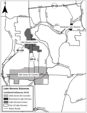
Figure 14.38-I Combined Subarea Locations
(Ord. 1027, Sec. 5, 2018; Ord. 876, Sec. 5 (Exh. 3), 2012)
14.38.015 Purpose.
This chapter provides detailed planning and zoning regulations for the subareas that supersede some sections of the Lake Stevens Municipal Code (LSMC). All development, within the subareas, is subject to the provisions of the LSMC, except when sections of this chapter modify the standard municipal code requirements or the section does not provide detailed provisions. (Ord. 876, Sec. 5 (Exh. 3), 2012)
14.38.017 Nonconformities.
The City will allow legal nonconformities to continue within the subareas subject to Chapter 14.32. Legal nonconforming signs may continue subject to Section 14.38.100(i). (Ord. 1132, Sec. 2 (Exh. A), 2021; Ord. 876, Sec. 5 (Exh. 3), 2012)
14.38.020 Zoning Districts.
The following zoning districts implement the goals, policies and distribution of land uses set forth in the subarea plans:
(a) Business District (BD). The purpose of this district is to promote community and regional employment and accommodate land uses such as corporate offices, general offices, research and development, medical clinics, technology, and light manufacturing and assembly. Secondary uses include warehousing, storage and distribution associated with a principal use and small-scale retail and services that support the principal uses and objectives of the district. This district should be located in areas with direct access to highways and arterials in addition to transit facilities, adequate public services and traffic capacity.
(1) Principal Uses.
(i) Educational services (colleges and/or technical schools);
(ii) Finance and insurance;
(iii) Health care services;
(iv) Light manufacturing and assembly;
(v) Management of companies and enterprises;
(vi) Professional, scientific, and technical services; and
(vii) Transit-oriented development (including transit facilities/stops).
(2) Secondary Uses.
(i) Food services;
(ii) Information services;
(iii) Personal services;
(iv) Retail trade;
(v) Wholesale trade;
(vi) Warehousing, storage and distribution;
(vii) Small wireless facilities/towers and antennas 50 feet tall or less; and
(viii) Eligible facility modifications.
(3) Special Regulations.
(i) Secondary service uses and retail trade shall not exceed 5,000 gross square feet;
(ii) Wholesale trade accessory to the principal use shall not exceed 25 percent of the gross floor area of individual structures, unless a conditional use permit is granted per Section 14.16C.045;
(iii) Places of worship over 10,000 gross square feet require a conditional use permit per Section 14.16C.045;
(iv) Macro facilities collocation on existing buildings/structures requires an administrative conditional use permit per Section 14.16C.015;
(v) Macro facilities (e.g., new tower, pole or structure)/towers and antennas more than 50 feet tall require a conditional use permit per Section 14.16C.045; and
(vi) Marijuana facilities are not allowed.
(b) Commercial District (CD). The purpose of this district is to accommodate the high-intensity retail needs of the community and regional market by attracting a mix of large to small format retail stores and restaurants to create a vibrant and unified regional shopping center. Transportation accessibility, exposure to highways and arterials with adequate public services and traffic capacity characterize this district.
(1) Principal Uses.
(i) Accommodation services;
(ii) Arts and entertainment;
(iii) Food services;
(iv) Retail trade; and
(v) Transit-oriented development (including transit facilities/stops).
(2) Secondary Uses.
(i) Amusement and recreation industries;
(ii) Commercial parking structures/lots;
(iii) Educational services (colleges and/or technical schools);
(iv) Finance and insurance;
(v) Health care services;
(vi) Information services;
(vii) Personal services;
(viii) Professional, scientific, and technical services;
(ix) Public administration;
(x) Warehousing, storage and distribution;
(xi) Small wireless facilities/towers and antennas 50 feet tall or less; and
(xii) Eligible facility modifications.
(3) Residential Uses.
(i) Mixed use multifamily residential units including apartments, condominiums, and live/work units, where the majority of residential units are located above commercial uses.
(4) Special Regulations.
(i) Health care, professional, scientific, and technical services require a conditional use permit per Section 14.16C.045 when the structure’s footprint exceeds 10,000 gross square feet;
(ii) Places of worship over 10,000 gross square feet require a conditional use permit per Section 14.16C.045;
(iii) Macro facilities collocation on existing buildings/structures requires an administrative conditional use permit per Section 14.16C.015;
(iv) Macro facilities (e.g., new tower, pole or structure), towers and antennas more than 50 feet tall require a conditional use permit per Section 14.16C.045;
(v) Warehousing, storage and distribution accessory to the principal use shall not exceed 25 percent of the gross floor area of individual structures, unless a conditional use permit is granted per Section 14.16C.045;
(vi) Outdoor retail sales of building materials, garden equipment and supplies, and vehicles are permitted;
(vii) Marijuana retail facilities are not allowed; and
(viii) Personal storage facilities may be permitted subject to the following regulations:
a. An administrative conditional use permit is required;
b. Standalone storage facilities with no other uses on the same site are prohibited;
c. Storage facilities shall not exceed 15 percent of the gross commercial floor area on the site;
d. Outdoor storage is prohibited;
e. The storage facility shall support at least one primary use on the project site or within the immediate vicinity; and
f. All other provisions of Section 14.44.044 that do not conflict with this section apply.
(c) Mixed Use Neighborhood (MUN). The purpose of this district is to accommodate higher density residential development in proximity to employment and retail centers and provide basic convenience goods and services in areas with available public services and adequate traffic capacities. This district would have a minimum density of 15 dwelling units per acre. This district would create a transition between higher and lower intensity land uses.
(1) Principal Uses.
(i) Multifamily apartments and condominiums;
(ii) Townhomes and row houses; and
(iii) Residential over retail/office including live/work units.
(2) Secondary Uses.
(i) Neighborhood-oriented retail trade and personal services that meet the convenience shopping and services needs of the immediate and surrounding area.
(ii) Small wireless facilities/towers and antennas 50 feet tall or less.
(iii) Eligible facility modifications.
(3) Special Regulations.
(i) Mixed use building configurations may include a vertical or horizontal stratification.
a. Retail and service uses located in attached mixed use buildings are limited to the ground level;
b. Sites with retail and service uses located in detached buildings are limited to a maximum floor area of 10,000 gross square feet;
c. Detached buildings with a footprint greater than 10,000 gross square feet require a conditional use permit per Section 14.16C.045;
d. Commercial uses should be oriented toward the primary frontage, with residential uses behind.
(ii) In the 20th Street SE Corridor, the district will allow innovative housing options per Chapter 14.46.
(iii) Automotive, boat, and recreational vehicle sales and services are not allowed.
(iv) Drive-through uses are not allowed between the building and right-of-way and are subject to screening requirements found in the applicable design guidelines.
(v) Macro facilities collocation on existing buildings/structures requires an administrative conditional use permit per Section 14.16C.015.
(vi) Macro facilities (e.g., new tower, pole or structure)/towers and antennas more than 50 feet tall require a conditional use permit per Section 14.16C.045.
(vii) Marijuana facilities are not allowed.
(viii) In the Downtown Lake Stevens Subarea, ground floor retail is required along Main Street NE frontages.
(d) Other Zones. The subareas may also contain the R8-12, R6, and Public/Semi-Public (P/SP) zoning districts, as described in Chapter 14.36 or as modified below.
(1) R8-12. Within the subareas, the purpose of the R8-12 district is to accommodate higher-density residential uses that may include multifamily condominiums, apartments, townhouses and row houses, as well as any small lot single-family residential units or innovative housing options per Chapter 14.46 in areas served by public water and sewer facilities, as well as the other uses described in Table 14.40-I. The dimensional standards for single-family residential districts shall be per Table 14.48-I.
(2) Public/Semi-Public (P/SP). Within the subareas, the purpose of P/SP district is to accommodate public and semi-public uses, such as schools, government facilities, public utilities, community facilities, parks, etc., as well as the other uses described in Table 14.40-I.
(e) Central Business District (CBD). The purpose of this district is to provide pedestrian-oriented commercial uses that serve the community and region by attracting a variety of small to mid-sized businesses along with high-density residential uses in proximity to other retail and residential areas. Building design and pedestrian-oriented features would support an active and pleasant streetscape. This district should include enhanced sidewalks, public spaces and amenities for pedestrians and cyclists that emphasize pedestrian movement over vehicular movement.
(1) Principal Uses.
(i) Amusement and recreation;
(ii) Arts and entertainment;
(iii) Food services;
(iv) Hospitality and lodging;
(v) Personal services; and
(vi) Small to mid-size retail trade.
(2) Secondary Uses.
(i) Commercial parking structures/lots;
(ii) Finance and insurance;
(iii) Health care services;
(iv) Professional, scientific, and technical services;
(v) Public administration;
(vi) Small wireless facilities/towers and antennas 50 feet tall or less; and
(vii) Eligible facility modifications.
(3) Residential Uses.
(i) Mixed use multifamily residential units including apartments, condominiums, and live/work units, where the residential units are located above or behind commercial uses.
(4) Special Regulations.
(i) Ground floor retail is required along Main Street and 18th St NE frontages.
(ii) Automotive, boat, and recreational vehicle sales and services are not allowed.
(iii) Drive-through uses are not allowed to front Main Street or 20th Street NE, but may be allowed on secondary streets.
(iv) Theaters and performing arts venues.
(v) The footprint of small to mid-size retail trade uses, in any single-use structure, may not exceed 30,000 gross square feet.
(vi) Health care, professional, scientific, or technical service structures’ footprints may not exceed 5,000 gross square feet.
(vii) Macro facilities collocation on existing buildings/structures requires an administrative conditional use permit per Section 14.16C.015.
(viii) Macro facilities (e.g., new tower, pole or structure)/towers and antennas more than 50 feet tall require a conditional use permit per Section 14.16C.045.
(ix) Marijuana facilities are not allowed. (Ord. 1179, Sec. 10, 2024; Ord. 1080, Sec. 5, 2020; Ord. 1048, Sec. 2 (Att. A), 2019; Ord. 1027, Sec. 5, 2018; Ord. 1009, Sec. 3, 2017; Ord. 923, Sec. 2 (Exh. A), 2015; Ord. 908, Sec. 6, 2014; Ord. 876, Sec. 5 (Exh. 3), 2012)
14.38.030 Other Uses.
The intent of all of the subarea zoning districts is to encourage a wide range of uses, while restricting uses that do not support the primary purpose of the zoning district. The identified uses are derived from the North American Industry Classification System (NAICS).
(a) Director’s Authority. The Director has the authority to determine if uses comply with the intent of the zoning district and support the principal uses and objectives of the district following the methodology described in Section 14.40.030(a) and based on a review of specific use categories defined in the NAICS.
(b) Prohibited Uses within the Subarea Districts:
(1) Adult entertainment;
(2) Construction facilities;
(3) Industrial uses, except as allowed in Section 14.38.020;
(4) Mining, quarrying, and oil and gas extraction;
(5) Waste management and remediation services;
(6) Uses involving outdoor sales and storage of inventory, equipment, vehicles, or materials, including towing, wrecking, and impound lots, except as allowed in Section 14.38.020(b); and
(7) Warehousing, storage and distribution, except as allowed in Section 14.38.020(a) and (b).
(c) Principal uses are the preferred uses of the zoning district, while secondary uses are also allowed uses, but should be subordinate in a mixed use configuration, whether in a vertical or horizontal configuration. The principal uses should be located along primary street frontages. (Ord. 1027, Sec. 5, 2018; Ord. 923, Sec. 2 (Exh. A), 2015; Ord. 876, Sec. 5 (Exh. 3), 2012)
14.38.040 Dimensional Regulations.
|
Zone |
Minimum Lot Size |
Building Setback (from lot line, tract or easement) (ft) |
Min. Landscape Buffer (ft)6 |
Min. First Floor Height (ft) |
Max. Height (ft)8, 10 |
|
|---|---|---|---|---|---|---|
|
Front |
Side/Rear |
|||||
|
Commercial Zones |
||||||
|
BD |
NA |
5 |
103, 4 |
5 |
12 |
55 |
|
CBD |
NA |
51 |
03, 4, 5 |
5 |
15 |
55 |
|
CD |
NA |
5 |
103, 4 |
5 |
15 |
559 |
|
Mixed Use Zones |
||||||
|
MUN |
NA |
102 |
104, 5 |
5 |
157 |
45 |
Notes:
1. The minimum required setback is five feet and the maximum allowed setback is 10 feet in the CBD district to allow an active storefront area.
2. The minimum required setback is 10 feet and the maximum allowed setback is 25 feet, subject to modifications defined in Section 14.16C.120.
3. Districts that allow commercial uses shall maintain a 10-foot, Type B screen when adjacent to residential zones, per Section 14.76.040(a).
4. Structures 35 feet or taller next to single-family districts must be stepped back five feet for every floor over 35 feet per Figure 14.38-II.
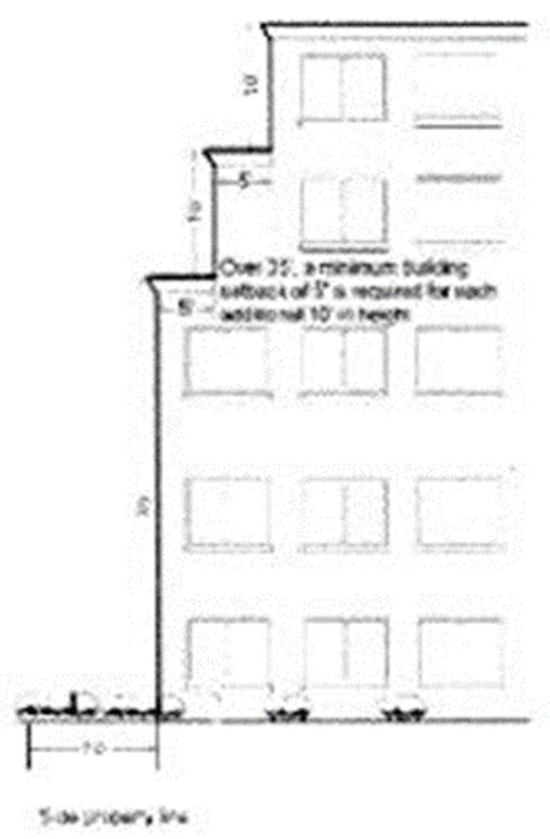
Figure 14.38-II illustrates stepping back the upper stories of a structure, adapted from the Everett Municipal Code.
5. Attached housing units or attached commercial structures built on separate lots can be built to the common property line. The outside setback for attached structures abutting a right-of-way, separate detached structures, or a different zone shall be 10 feet.
6. Landscape buffers will be comprised of a Type C screen per Section 14.76.040(a) along side and rear property lines; however, the City may waive the landscape buffer when adjacent properties share parking, access, or other common features that make intensive landscaping impractical. In addition, perimeter landscape buffer along property lines of adjacent high-density single-family lots is not required; however, screening different developments from neighboring properties will provide separation, vegetation and define each development.
7. The first floor height of residential structures in the MUN district, without an attached retail/service component, not facing a public right-of-way may be reduced to industry standard.
8. If a project includes a parking structure or affordable housing as described in Section 14.38.050(a), the City will also allow an overall height increase of 10 feet above maximum height.
9. The City will consider an increase in maximum height up to 80 feet with a conditional use permit per Section 14.16C.045.
10. Building heights in the CBD and P/SP zoning districts west of Main Street between North Lakeshore and 16th Street NE may not exceed 45 feet.
(Ord. 1179, Sec. 10, 2024; Ord. 1080, Sec. 5, 2020; Ord. 1027, Sec. 5, 2018; Ord. 903, Sec. 26, 2013; Ord. 876, Sec. 5 (Exh. 3), 2012)
14.38.050 Development Bonuses.
(a) To encourage quality commercial and mixed use development that incorporates enhanced elements that provide either a public, social or environmental benefit, the city will allow a 10-foot height increase above the maximum height for projects including any two of the following elements. These bonus provisions do not apply in the downtown Lake Stevens Subarea.
(1) Public Plaza. This is an outdoor space not less than 500 square feet in size, or less than 20 feet in dimension, provided at the ratio of 1.5 square foot of plaza per 100 square feet of building area beyond any other required plaza area.
(i) The public plaza must contain substantial design features, defined in the applicable design guidelines.
(ii) For larger development sites, the total percentage of area used as a public plaza may be allocated among multiple spaces, so long as each public plaza area complies with the criteria in subsection (a)(1)(i) of this section.
(iii) Outdoor seating for restaurants adjacent to the plaza may occupy up to 20 percent of the total area.
(iv) The public plaza shall be open to the public during business hours.
(2) Public Art.
(i) The value of the artwork must equal at least one percent of the value of the total project construction.
(ii) The artwork must be displayed in a prominent outdoor location (such as a plaza, sidewalk, wall, entry) for public viewing.
(iii) The City must approve the form and content of the proposed artwork.
(3) Public Use. Any use normally provided by government, involving general public access that may include a post office, library, City offices, community center, museum, interpretive center, meeting rooms, visitor information centers, etc. Purely administrative space, storage or maintenance operations do not qualify.
(4) Public Restroom. A single unisex restroom or two gender-specific restrooms open to the public during normal business hours with signs posted in prominent locations that inform the public of its availability and location.
(5) Parking Facilities. In order to qualify for this bonus feature, a minimum of 60 percent of the parking for the development must be contained within the principal structure and/or in an adjacent detached structure.
(6) Sustainable Development Feature. New construction or significant alterations are encouraged to use “green” building methods and incorporate low impact development techniques, be highly energy efficient, and/or seek varying levels of Leadership in Energy and Environmental Design (LEED) certification. To qualify for this bonus, the development must include at least one of the following:
(i) Achieve LEED Certification (Silver, Gold, Platinum Rating) or equivalent; and/or
(ii) Employ low impact development techniques that may include a combination of the use of high-efficiency building materials, “green-roofs,” porous paving, tree retention, rain gardens, or other methods, as defined in the Low Impact Development Technical Guidance Manual for Puget Sound; and/or
(iii) Provide incentives for alternative or high-efficiency transportation modes that may include a combination of priority HOV spaces, bicycle parking, and/or electrical hookups for electric vehicles.
(7) Affordable Housing. Provide at least 15 percent of any housing units, contained within the development, as affordable housing to diverse households.
(i) The maximum housing costs for rental units including basic utilities shall not exceed 30 percent of the average median income limit for a comparable housing unit within Snohomish County.
(ii) The maximum sales price for any housing unit shall not exceed 80 percent of the average median sales price for a comparable market rate home within Snohomish County. All affordable units developed under this chapter shall remain affordable, as defined in this section, for a period of not less than 30 years, or the minimum period required under applicable state law.
(iii) Prior to issuance of a certificate of occupancy, the proponent shall record a binding covenant, with the Snohomish County Auditor’s Office, that specifies the terms and conditions of the affordable units to assure that the units remain affordable as required under this section, in a form approved by the City.
(iv) Affordable units shall be dispersed throughout the housing development with market rate units; constructed concurrently with market rate units; and provided in a range of sizes, with comparable interior and exterior appearance and a similar number of bedrooms to market rate units in the housing development.
(v) In the case of developments constructed solely to provide affordable housing, whether owner-occupied or rental, the development shall provide housing units comparable to market rate units, as defined in subsection (b)(7)(iv) of this section, available to other residents within Lake Stevens.
(8) Contribution to Off-Site Public Space. To qualify for this bonus, the developer shall contribute monetarily to the construction of a public trail, park or plaza located within the subarea. The contribution shall not be less than two percent of the construction cost of the development and separate from any park mitigation fees assessed under Chapter 14.120 or other credits for fees in lieu related to development. The City shall maintain any contributed funds in a dedicated account for the public space(s). (Ord. 1027, Sec. 5, 2018; Ord. 876, Sec. 5 (Exh. 3), 2012)
14.38.060 Parking Regulations.
(a) Purpose and Application. Ensure that parking requirements are adequate to different land uses and that the parking lot configurations contribute to an inviting and safe development. Developments within the subareas are subject to the parking regulations found in Chapter 14.72, except when this chapter modifies the standard municipal code requirements.
(b) Parking Ratio. Table 14.38-III establishes the specific parking requirements for the subareas.
|
Land Use |
Minimum |
Maximum |
|---|---|---|
|
Commerce and Industry (per gross floor area) |
||
|
Health Care |
2.5 stalls per 1,000 gfa |
5 stalls per 1,000 gfa |
|
Office and Business Services |
2 stalls per 1,000 gfa |
4 stalls per 1,000 gfa |
|
Food Services |
10 stalls per 1,000 gfa |
20 stalls per 1,000 gfa |
|
Retail Trade and Personal Services |
2 stalls per 1,000 gfa |
4 stalls per 1,000 gfa |
|
Wholesale Trade |
1 stall per 1,000 gfa |
2 stalls per 1,000 gfa |
|
Hotel |
0.75 stalls per room |
1 stall per room |
|
Conference Center |
1 stall per 50 gfa |
1.5 stalls per 50 gfa |
|
Residential (per residential unit or room) |
||
|
Group, Convalescent and Nursing Homes |
1 per room |
1.5 per room |
|
Multifamily Residential4 |
1.25 stalls per unit5 |
2.5 stalls per unit6 |
|
Senior Housing |
0.5 stalls per unit |
1 stall per unit |
|
Single-Family Residential |
2 per unit |
NA |
Notes:
1. Where an adopted subarea plan establishes parking standards for a use or zoning district that differs from this table, the standards in the subarea plan shall prevail.
2. Parking requirements for uses not listed shall be per Table 14.72-I: Table of Parking Requirements in Section 14.72.010.
3. Off-street parking shall include the sum of the requirements for the various uses as listed in the required parking table or consistent with subsection (c) of this section. For example, if a site has office and residential uses, the parking area would need to include the required number of parking spaces for both uses.
4. Includes mixed use developments.
5. One and one-quarter spaces minimum to a maximum of two spaces for units with one or less bedrooms.
6. Two and one-quarter spaces minimum to two and one-half maximum for units with two or more bedrooms.
(c) Modifications. The Director or designee may approve a modification (increase or decrease) of up to 25 percent of the required off-street parking spaces.
(1) Parking may be located off site in satellite parking lots, subject to Section 14.72.080, if the satellite parking lot is within 400 feet of the property and connected to the property by a lighted sidewalk or pathway.
(2) In cases where there are compatible uses within 400 feet of each other, operated or used at entirely different times of the day or week, the uses may share the parking facilities, subject to Section 14.72.070 and by execution of a parking agreement, approved by the City, between the owners or responsible officials of the compatible uses.
(3) Increases above the maximum allowed parking standard will be allowed when a traffic/parking study, conducted for a similar use and circumstances, documents that a particular use consistently requires a higher parking standard for the use than allowed.
(4) For zones that contain on-street parking spaces along improved frontages, adjacent uses may reduce their off-street parking requirements by a maximum 25 percent based upon a parking study demonstrating adequate on-street parking availability.
(d) Configuration. Parking lots shall be configured as follows:
(1) Parking lots that front on designated access streets may not have more than 60 feet fronting on such street, in the CD zoning district modifications may be allowed on a case-by-case basis according to Section 14.16C.120.
(2) Parking lots that contain 50 or more parking spaces must be divided into smaller individual lots of no more than 50 spaces per lot.
(3) Individual lots must be separated with one of the following elements that are elevated approximately six inches above the adjacent parking lot:
(i) A minimum 10-foot-wide Type C landscape screen per Section 14.76.040(a)(3) within a planter bed; or
(ii) A minimum five-foot-wide pedestrian pathway flanked on each side with a two-foot-wide Type C landscape screen per Section 14.76.040(a)(3) within a planter bed.
(4) Parking areas shall be divided into bays of not more than 10 contiguous parking spaces in a row.
(5) At the end of each parking bay, there shall be a curbed planter with a minimum width of five feet measured from the outside of the curb.
(6) All parking spaces adjacent to landscape beds must provide a setback for all trees and shrubs where vehicle overhang extends into landscape areas by:
(i) Increasing planting bed to seven feet in width; or
(ii) Installing wheel stops set back two feet from the end of planting bed.
(7) Commercial parking lots need not comply with subsections (d)(1) and (d)(3) of this section, but must provide a perimeter landscaping and defined pedestrian walkway(s) to the abutting public road. Fences and low walls along sidewalk areas may not exceed 42 inches. Commercial parking structures are exempt from the requirements of this subsection (d), but must otherwise meet the requirements of Chapter 14.38. (Ord. 1179, Sec. 10, 2024; Ord. 1027, Sec. 5, 2018; Ord. 876, Sec. 5 (Exh. 3), 2012)
14.38.070 Landscaping, Screening, and Natural Vegetation.
(a) Purpose and Application. Ensure that landscaping complements the architecture of the development and creates an inviting environment. Developments within the subareas are subject to the landscaping, screening, tree retention, and vegetation regulations found in Chapter 14.76 except when this chapter modifies the standard municipal code requirements.
(b) Planting Requirements. Each planter shall contain at a minimum:
(1) One shade tree (minimum two-inch caliper) per parking area planting bed or one tree per 30 feet along paths, perimeters, or other linear planting areas;
(2) One two-gallon shrub for every 10 square feet of landscape area; and
(3) Mulch to a depth of three inches.
(c) Irrigation. All landscaped areas shall provide underground irrigation, unless the landscape area is planted entirely with drought resistant native or naturalized plants.
(d) Maintenance of Landscaping.
(1) The property owner or responsible lessee shall maintain all landscaped areas in a healthy and safe manner; ensure landscaped areas remain free of weeds and debris; and replace dead or diseased plants with in-kind plants.
(2) The property owner or responsible lessee shall provide eye level visibility between the street, sidewalks, buildings, and parking areas:
(i) The property owner or responsible lessee shall prune shrubs and other low plantings to a height of three feet or less above the ground; and
(ii) The property owner or responsible lessee shall prune lower branches of mature trees to approximately eight feet above the ground. (Ord. 876, Sec. 5 (Exh. 3), 2012)
14.38.080 Lighting.
(a) Lighting design must comply with the Illuminating Engineering Society of North America’s Lighting Handbook or Recommended Practices and Design Guidelines, latest editions, for each applicable lighting type.
(b) Lighting Levels and Shielding.
(1) Exterior lighting fixtures shall include timers, dimmers, sensors, or controllers that turn the lights off during daylight hours.
(2) Exterior lighting fixtures shall avoid harsh contrasts in lighting levels, prevent glare from normal viewing angles, and shield adjacent properties from light sources.
(i) Light fixtures shall not have bulbs or reflectors that project below the bottom rim of the fixture unless shielded by a softening diffuser.
(ii) Parking lot lighting fixtures should create adequate visibility at night and provide uniform lighting coverage to increase security.
(iii) Lighting levels shall be a maximum of two-tenths foot candles, measured five feet or beyond from an exterior property line.
(3) Lighting fixtures used to accent architectural features, materials, colors, style of buildings, or art shall be directed only to highlight those features.
(c) Height Standards.
(1) Lighting fixtures used in parking lots shall not exceed a maximum height of 30 feet.
(2) Lighting fixtures over 16 feet in height shall be fitted with a full cut-off shield.
(3) Lighting fixtures along sidewalks and paths shall not exceed a maximum height of 16 feet.
(d) Maintenance.
(1) Lighting fixtures used for safety and security shall be maintained in good working order.
(2) Vegetation and landscaping shall be maintained in a manner that does not obstruct lighting fixtures. (Ord. 876, Sec. 5 (Exh. 3), 2012)
14.38.090 Street Standards.
(a) Purpose and Application. Provide a street network unique to the subareas that emphasizes multi-modal travel and grid connectivity. Street design, within the subareas, is subject to the street and sidewalk standards found in Chapter 14.56, except when this chapter modifies the standard municipal code requirements.
(b) Street classifications shall be per the applicable subarea plan’s layered street network, but follow individual construction standards found in the current City’s Engineering Design and Development Standards.
(c) Block lengths should not exceed 400 feet in length; shopping districts should provide mid-block crosswalks to allow additional crossing opportunities.
(d) Vehicular driveways for ingress and egress are encouraged to be located off arterials, whenever possible, to minimize the number of driveways and curb cuts onto public streets.
(e) Adjacent developments should share driveways, for ingress and egress, to the greatest extent possible (cross-over agreements between properties strongly encouraged).
(f) The sidewalk pattern and material shall continue across the driveways and curb cuts. (Ord. 876, Sec. 5 (Exh. 3), 2012)
14.38.100 Signs.
(a) Purpose and Application. Ensure that signage provides effective advertising and identification with appropriate design, scale, and placement. Developments within the subareas are subject to the sign regulations found in Chapter 14.68 and applicable design guidelines, except when this chapter modifies the standard municipal code requirements.
(b) Allowed Signs.
(1) Changeable text signs per Section 14.68.084.
(2) Freestanding signs.
(3) Informational/directional signs.
(4) Projecting/suspended signs.
(5) Residential signs per Section 14.68.090.
(6) Signs excluded from regulation per Section 14.68.020.
(7) Temporary signs per Section 14.68.030.
(8) Wall signs.
(9) Window signs.
(c) Prohibited Signs.
(1) Animated or flashing signs, except as allowed in Section 14.68.120.
(2) Off-site signs, except as allowed by Section 14.68.030 and subsection (f) of this section.
(3) Portable signs.
(4) Roof signs.
(5) Signs which are located on or extend over public rights-of-way.
(6) Temporary signs except as allowed by Section 14.68.030.
(d) Projecting/Suspended Signs, Wall Signs, and Window Signs.
(1) Table 14.38-IV establishes the dimensional and quantitative requirements for projecting/suspended signs, wall signs, and window signs.
(2) Projecting/Suspended Signs.
(i) Projecting signs shall not extend more than five feet from a building facade;
(ii) Suspended signs are limited to approximately two inches in thickness and may not extend beyond the structure to which it is attached;
(iii) Projecting/suspended signs must provide a minimum of eight feet of clearance from the ground to the bottom of the sign; and
(iv) A minimum spacing of 20 feet between signs must separate projecting/suspended signs.
(3) Wall Signs.
(i) Wall signs shall be generally located in the storefront area above the main entrance along primary facades and beneath the roofline or cornices on secondary facades;
(ii) Second story signs shall be generally located directly above or below windows, but not higher than the belt course between the next story or below the roofline or cornices, as illustrated in Figure 14.38-IV;
(iii) Wall signs shall be generally centered between defined architectural elements and may not extend beyond defined architectural features;
(iv) Wall signs may be located on building focal points, if the sign does not extend beyond defined architectural features;
(v) Wall signs shall not project more than 10 inches from the building;
(vi) Wall signage may be located on awnings and marquees or similar structures only when the design of the building facade prohibits wall signs on the storefront facade and the signage does not extend beyond defined architectural features; and
(vii) The wall sign area calculation is defined in Table 14.38-IV and the maximum sign area per facade will be based on the size of the associated gross business area, as follows:
a. Five thousand gross square feet or less: 32 square feet;
b. Five thousand one to 15,000 gross square feet: 96 square feet; and
c. Over 15,001 gross square feet: 192 square feet.
(viii) Sign area is not transferable.
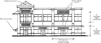
Figure 14.38-IV Signage Placement Diagram from Mill Creek Town Center Design Guidelines
|
Sign Type1 |
BD |
CD2 |
NB |
MS2 |
CBD |
MUN2 |
|
|---|---|---|---|---|---|---|---|
|
Projecting/Suspended |
Sign Area |
NA |
10 sq. ft. max. and no more than 5 ft. in width |
6 sq. ft. max. and no more than 3 ft. in width |
|||
|
Maximum Number |
NA |
1 projecting or suspended sign per main facade or leasable frontage |
|||||
|
Wall3 |
Sign Area |
Main: 10% of building facade Secondary: 5% of building facade6 |
Main: 15% of building facade Secondary: 10% of building facade6 |
Main: 10% of building facade Secondary: 5% of building facade6 |
|||
|
Maximum Number |
1 per facade 2 facades may have signs |
1 per facade4 3 facades may have signs |
1 per facade 2 facades may have signs |
||||
|
Window5 |
Sign Area |
10% percent of window area |
20% percent of window area |
10% percent of window area |
|||
Notes:
1. Each leased space or building frontage may have one projecting sign or one suspended sign, but not both.
2. Residential signage shall conform to Section 14.68.090.
3. Wall sign calculation: the facade area (first 12 feet of the building height) multiplied by the total facade length or leasable frontage for multi-tenant buildings (example: [12 x 30 = 360] [360 x 15% = 54 sq. ft.]). The sign calculation for second story signage would be the leasable frontage multiplied by the height of the story (example: [12 x 20 = 240] [240 x 15% = 36 sq. ft.]).
4. Building over 15,000 gross square feet, with a primary facade length over 100 linear feet, may have two signs along the primary facade for the primary businesses and one sign per enclosed secondary business. Sign area for all signs will be included in the maximum sign area.
5. Commercial signage for businesses on third stories and above would be limited to window signs.
6. Main facade is defined as a facade with a primary pedestrian entrance; there may be more than one main facade. All other facades are secondary. The maximum number of facades (main or secondary) shall follow Table 14.38-IV.
(e) Freestanding Signs.
(1) Table 14.38-V establishes the dimensional and quantitative requirements for freestanding signs including monument and pole/pylon signs.
(2) Freestanding signs shall be located no closer than five feet to public rights-of-way or access easements measured from the face of the sign to the back of the ROW or easement.
(3) No signs shall obstruct sight distance at street intersections or driveways per Section 14.68.120(d).
(4) The height of freestanding signs shall be measured from the average ground level at the sign’s base.
(5) Freestanding signs must provide an architectural base, with a minimum height of 12 inches.
(6) Each freestanding sign shall provide a landscaped area around the base of the sign per the following:
(i) One and one-quarter square feet of landscaping per one square foot of sign area with a minimum area of 50 square feet and a minimum width of five feet measured from the outside of the curb or the edge of the landscape bed;
(ii) The landscape area and sign base shall be protected from vehicles by a six-inch curb, if adjacent to drive aisles or parking areas;
(iii) The landscape area must include a mix of shrubs, perennials and/or annual flowers, and other standard landscape material; and
(iv) The landscape area may include other materials and components such as brick or concrete bases, planter boxes, pole covers, decorative framing, and accent lighting.
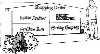
Figure 14.38-V Monument Sign
|
Sign Type |
CD |
NB |
BD |
MS |
CBD |
MUN |
|
|---|---|---|---|---|---|---|---|
|
Monument |
Sign Area1 (sq. ft.) |
75 |
50 |
50 |
50 |
25 |
25 |
|
Sign Height |
15 ft. |
10 ft. |
10 ft. |
5 ft. |
5 ft. |
5 ft. |
|
|
Number2, 3, 4 |
1 |
1 |
1 |
1 |
1 |
1 |
|
|
Pole/Pylon5 |
Sign Area1 (sq. ft.) |
100 |
NA |
NA |
100 |
NA |
NA |
|
Sign Height |
20 ft. |
20 ft. |
|||||
|
Number |
1 |
1 |
|||||
Notes:
1. For freestanding signs with multiple faces, only the sign area of a single face is calculated per Section 14.68.040.
2. Each site with commercial uses may install one freestanding identification sign or multi-tenant identification sign per site.
3. Commercial centers with more than one frontage may install two identification and/or multi-tenant identification signs with one freestanding sign along the primary frontage and a second sign along the secondary frontage, with a minimum separation of 100 feet between the signs, including separation of off-site and highway-oriented signs. Freestanding signs located along secondary frontages must be reduced by 25 percent in sign area and height.
4. Any detached structure greater than 5,000 square feet in gross area, occupied by a single business, located on a defined building pad, within a commercial center over five acres may have an additional freestanding sign not exceeding 25 square feet in area and having a maximum height of five feet.
5. Pole/pylon signs are limited to highway-oriented sign requirements pursuant to subsection (f) of this section.
(f) Off-Site Signage.
(1) The provisions contained in this section recognize the need for certain businesses located within the Commercial district, Business district and Main Street district, in proximity to state highways (SR-9 and SR-204) and/or major arterials, but with limited visibility to install off-site signs.
(2) The City shall review the need for off-site signage against the following criteria:
(i) The business(es) is located more than 100 feet from the right-of-way, measured from the nearest point to the edge of right-of-way;
(ii) The business(es) shall demonstrate that on-site signs cannot adequately convey the location and identity of the business(es) because of poor visibility or traffic patterns unique to its location;
(iii) The off-site sign does not create adverse impacts to surrounding businesses, pedestrians, or motorists including, but not limited to, glare and sight obstructions;
(iv) The sign is not out of scale or character with allowed signs for nearby uses and employs distinct architectural features associated with the primary building or complex;
(v) The advertising structure does not detract from the goals, objectives, and policies of the subarea plan; and
(vi) The applicant has provided a recorded easement or expressed written permission, including maintenance provisions, from the property owner of the premises where the off-site sign is to be located.
(3) Content of Off-Site Signage.
(i) The off-site sign contains a message area that identifies the complex by name or district and may contain its address;
(ii) The off-site sign identifies one or more businesses in the complex or district by name and may include corporate logos; and
(iii) The off-site sign contains directional information, such as exit number, route information (e.g., next left), and may contain directional arrows.
(iv) The off-site sign may not include promotional information for individual businesses or display or support temporary signs, banners, pennants, etc.
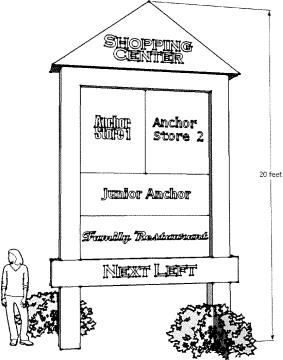
Figure 14.38-VI Off-Site Sign
(g) Informational/directional signs mean signs within a commercial or business park development that convey information; indicate the name of a particular use, such as “pharmacy” or “lumber”; and provide direction to specific uses such as “drive-through” or “exit,” but do not contain specific advertising, except for building directories.
(1) Attached signs are limited to a maximum of two percent of the building facade or leased storefront area.
(2) Freestanding signs are limited to a maximum of four square feet.
(3) Building directories are limited to a maximum of 10 square feet for the purpose of identifying upper floor tenants or first floor tenants that do not have outside building frontage adjacent to the entrance for such businesses.
(4) Primary restaurant menu signs are limited to a maximum of 32 square feet and secondary menu signs are limited to a maximum of 12 square feet. Only one menu sign of each type is allowed per business. Menu signs are subject to the design requirements for freestanding signs.
(h) Sign Modifications. To provide flexibility, the City will consider modifications to the sign regulations for signs that display outstanding design elements per the requirements of Section 14.68.124.
(i) Legal Nonconforming Signs.
(1) All legally existing signs at the time of the adoption of the ordinance codified in this chapter that are not in compliance with the requirements of this chapter are nonconforming signs. The burden of establishing a sign’s legal status, under this chapter, is the responsibility of the sign or business owner.
(2) Legal nonconforming signs are subject to the requirements of Section 14.68.150 (Nonconforming Signs).
(3) Violations. Any violation of this chapter shall terminate immediately the right to maintain a legal nonconforming sign. (Ord. 1179, Sec. 10, 2024; Ord. 1027, Sec. 5, 2018; Ord. 903, Sec. 27, 2013; Ord. 876, Sec. 5 (Exh. 3), 2012)
14.38.110 Design Standards and Guidelines.
All development within the subarea districts shall comply with the adopted Subarea Design Guidelines. (Ord. 876, Sec. 5 (Exh. 3), 2012)
14.38.120 Planned Action and Mitigation.
(a) Purpose. The purpose of this chapter is to:
(1) Designate areas and land uses that qualify as a planned action for purposes of environmental review of subsequent implementing projects pursuant to the State Environmental Policy Act (SEPA), Chapter 43.21C RCW;
(2) Establish criteria and procedures to determine whether projects qualify as planned actions;
(3) Streamline and expedite the land use review and approval process by relying on the environmental impact statement (EIS) completed for the planned action, including draft and final EIS; and
(4) Apply the City’s development regulations together with the mitigation measures described in the EIS, planned action ordinance and this chapter to address the impacts of future development contemplated by the planned action.
(b) Planned Action Procedures.
(1) Planned Action Area. The planned action designation shall apply to those areas, identified on the Official Zoning Map, and according to the individual adopting ordinances. Each area has specific development thresholds that will be reviewed and documented for the appropriate area:
(i) The Lake Stevens Center Subarea;
(ii) The 20th Street SE Corridor Subarea; and
(iii) The Downtown Lake Stevens Subarea.
(2) Environmental Document. A planned action determination for a qualifying project shall be based on the environmental analysis contained in the applicable planned action EIS, as published or hereafter revised, for the areas identified in subsections (b)(1)(i) and (ii) of this section.
(3) Planned Action Designated. Land uses and activities described in the applicable planned action EIS, subject to the thresholds described in subsection (c) of this section and the mitigation measures contained in subsection (d) of this section, are designated planned actions or planned action projects pursuant to Chapter 43.21C RCW.
(4) Pre-Application Conference. Applications for a planned action certification require a pre-application conference with City staff pursuant to Section 14.16A.220(d).
(5) Public Notice. Public notice requirements for qualifying projects are considered Type II permits pursuant to Section 14.16B.225. Notice shall be mailed or otherwise verifiably provided to:
(i) All affected federally recognized tribal governments; and
(ii) Agencies with jurisdiction over the future development anticipated for the planned action.
The notice shall state that the project has qualified as a planned action. Other notice may be required for the underlying permit.
(c) Development Thresholds.
|
|
Lake Stevens Center |
20th Street SE Corridor |
Downtown Lake Stevens |
|---|---|---|---|
|
Land Use |
|||
|
Retail and Services |
150,000 gross sq. ft. |
450,000 gross sq. ft. |
170,000 gross sq. ft. |
|
Office/Employment |
150,000 gross sq. ft. |
1.25 million gross sq. ft. |
71,150 gross sq. ft.1 |
|
Residential |
200 dwelling units |
1,000 dwelling units |
600 dwelling units |
|
Parking |
|
|
300 parking spaces2 |
|
Transportation (PM peak hour) |
|||
|
Total Trips |
915 |
3,441 |
1,740 |
Notes:
1. The office/employment category includes 50,000 square feet of office/employment uses and an additional 21,150 square feet of community facilities.
2. In the Downtown Lake Stevens Subarea, the parking category refers to public or commercial parking lots, not individual parking spaces required for each individual land use.
(d) Mitigation Measures.
(1) The specific mitigation measures identified for the Lake Stevens Center Subarea are contained in Exhibit B of Ord No. 877.
(2) The specific mitigation measures identified for the 20th Street SE Corridor Subarea are contained in Exhibit B of Ord No. 878.
(e) Planned Action Review Criteria.
(1) The SEPA Responsible Official will designate applications that meet the following criteria as qualifying projects, pursuant to Chapter 43.21C RCW, WAC 197-11-164, and this chapter when the project meets the following criteria:
(i) The proposal is located within a planned action area as identified on the Official Zoning Map;
(ii) The proposal is consistent with the City of Lake Stevens Comprehensive Plan and the applicable subarea plan;
(iii) The proposed uses and activities are consistent with those described in the planned action EIS and zoning requirements of Section 14.38.020;
(iv) The proposal is consistent with the cumulative planned action thresholds identified in Table 14.38-VI of subsection (c) of this section;
(v) The proposal’s significant adverse environmental impacts have been identified in the planned action EIS;
(vi) The proposal’s significant impacts have been mitigated by application of the measures identified in subsection (d) of this section, and other applicable City regulations, together with any modifications, variances, or special permits that may be required;
(vii) The proposal complies with all applicable local, state and/or federal laws and regulations and the SEPA Responsible Official determines that these constitute adequate mitigation; and
(viii) The proposal is not an essential public facility as defined by RCW 36.70A.200(1) and Section 14.16C.060, except as permitted by Chapter 43.21C RCW.
(2) The City shall base its decision on review of a SEPA checklist, or an alternative form, adopted pursuant to Chapter 43.21C RCW, and review of the application and supporting documentation.
(f) Effect of Planned Action.
(1) Upon determination by the SEPA Responsible Official that the proposal qualifies as a planned action, in accordance with this chapter, the proposal shall not require a SEPA threshold determination or be subject to further environmental review pursuant to SEPA.
(i) Following this determination, the City will provide the applicant with written certification that their project qualifies as a planned action project and that it is subject to the final conditions of project approval.
(2) Projects that create a substantial change in the type or degree of impacts analyzed in the planned action EIS would not qualify as a planned action.
(3) Should environmental conditions change significantly from those analyzed in the planned action EIS, the SEPA Responsible Official may determine that the planned action designation is not applicable until:
(i) The applicant provides supplemental environmental review limited to those issues and environmental impacts not previously addressed or that are inconsistent with the planned action EIS; or
(ii) The applicant undergoes a separate SEPA review consistent with the City’s SEPA regulations and the requirements of state law.
(g) Monitoring and Review.
(1) The City will monitor development progress in the designated planned action area to ensure it is consistent with the applicable planned action EIS regarding the type and amount of development and associated impacts, and with the mitigation measures and improvements planned for the individual subareas.
(2) The SEPA Responsible Official shall review the planned action ordinance no later than five years from its effective date to determine the continuing relevance of its assumptions and findings with respect to environmental conditions in the planned action areas, the probable impacts of development, and required mitigation measures. Based on this review, the City may amend, addend, or supplement the planned action ordinance and/or EIS.
(3) If, during monitoring, a project proposal, within the planned action area, is nearing the development thresholds or full build-out capacity identified in the planned action EIS, the SEPA Responsible Official shall determine if the planned action ordinance and/or EIS warrant amendments, addenda, or supplemental analysis. (Ord. 1027, Sec. 5, 2018; Ord. 876, Sec. 5 (Exh. 3), 2012)