


Chapter 18.36
CRITICAL AREAS DEVELOPMENT REGULATIONS
Sections:
Article I. General Provisions
18.36.020 Best available science.
18.36.040 Abrogation and greater restrictions.
18.36.060 Applicability and critical area mapping.
18.36.110 Single-family residence administrative exception.
18.36.120 Reasonable use exception.
18.36.130 Critical areas review process.
18.36.150 Critical areas report.
18.36.160 Mitigation sequencing.
18.36.170 Mitigation requirements.
18.36.200 Critical areas tracts.
18.36.220 Subdivisions, short subdivisions, planned unit developments and binding site plans.
18.36.230 Security to ensure mitigation, maintenance, and monitoring.
18.36.240 Unauthorized critical areas alterations and enforcement.
Article II. Wetlands
18.36.310 Wetlands designation and classification.
18.36.320 Additional critical areas report requirements.
18.36.330 Performance standards.
18.36.340 Wetland mitigation requirements.
Article III. Critical Aquifer Recharge Areas
18.36.410 Critical aquifer recharge areas designation.
18.36.420 Performance standards.
18.36.430 Uses prohibited from critical aquifer recharge areas.
Article IV. Geologically Hazardous Areas
18.36.510 Geologically hazardous areas designation.
18.36.520 Geological hazard report requirements.
18.36.525 Adjustment to report requirements.
18.36.530 Performance standards.
Article V. Fish and Wildlife Habitat Conservation Areas
18.36.610 Fish and wildlife habitat conservation areas designation.
18.36.620 Water type classification.
18.36.630 Additional critical areas report requirements.
18.36.640 Performance standards.
Article VI. Frequently Flooded Areas
18.36.710 Frequently flooded areas.
Article I. General Provisions
18.36.010 Purpose.
(1) The purpose of this critical areas ordinance is to designate and protect ecologically sensitive and hazardous areas in accordance with the Washington Growth Management Act (GMA), while also allowing for reasonable use of property and assuring the property rights of others. The city is inside an urban growth area of the GMA.
(2) By limiting and regulating development and alteration of critical areas while reflecting local conditions and the priorities of Normandy Park, this chapter seeks to:
(a) Protect members of the public and public resources and facilities from injury, loss of life, or property damage due to landslides and steep slope failures, erosion, seismic events, or flooding;
(b) Maintain healthy, functioning ecosystems through the protection of unique, fragile, and valuable elements of the environment, including ground and surface waters, wetlands, and fish and wildlife and their habitats, and to conserve the biodiversity of plants and animal species;
(c) Direct activities not dependent on critical areas resources to less ecologically sensitive sites and mitigate unavoidable impacts to critical areas by regulating alterations in and adjacent to critical areas; and
(d) Prevent cumulative adverse environmental impacts and the overall net loss of the functions and values of wetlands and fish and wildlife habitat conservation areas. Where reasonably possible this chapter seeks to increase the functions and values of wetlands and fish and wildlife habitat conservation areas.
(3) This chapter is to be administered with flexibility and attention to site-specific characteristics. It is not the intent of this chapter to apply standards for undeveloped property to previously developed property currently in use, to make a parcel of property unusable by denying its owner reasonable use of the property or to prevent the provision of public facilities and services necessary to support existing development and that planned for by the community.
(4) This chapter does not apply to activities that changed the character, size, or scope of any development prior to the effective date of the ordinance codified in this chapter, including the design and drainage, dredge, flood, fill, landscaping or otherwise altered critical areas. (Ord. 997 § 3 (Exh. B), 2019; Ord. 825 § 3 (Exh. A), 2009).
18.36.020 Best available science.
(1) Critical areas reports and decisions to alter critical areas shall rely on the best available science to protect the functions and values of critical areas and must give special consideration to conservation or protection measures necessary to reasonably preserve or enhance anadromous fish, such as salmon and bull trout, and their habitat.
(2) The best available science is that scientific information applicable to the critical area prepared by local, state, or federal natural resource agencies, a qualified scientific professional, or team of qualified scientific professionals that is consistent with criteria established in WAC 365-190-080 and 365-195-900 through 365-195-925, or as amended. (Ord. 997 § 3 (Exh. B), 2019; Ord. 825 § 3 (Exh. A), 2009).
18.36.030 Authority.
As provided herein, the city manager, or his or her designee, is given the authority to interpret and apply, and the responsibility to enforce, this chapter to accomplish the stated purpose. The city manager or designee is authorized to adopt administrative rules as necessary and appropriate to implement this chapter and to prepare and require the use of such forms as necessary for its administration. (Ord. 997 § 3 (Exh. B), 2019; Ord. 825 § 3 (Exh. A), 2009).
18.36.040 Abrogation and greater restrictions.
Any individual critical area adjoined by another type of critical area shall have the buffer and meet the requirements that provide the most protection to the critical areas involved. When any provision of this chapter or any existing regulation, easement, covenant, or deed restriction conflicts with this chapter, that which is more restrictive shall apply. (Ord. 997 § 3 (Exh. B), 2019; Ord. 825 § 3 (Exh. A), 2009).
18.36.050 Severability.
If any clause, sentence, paragraph, section, or part of this chapter or the application thereof to any person or circumstances shall be judged by any court of competent jurisdiction to be invalid, such order or judgment shall be confined in its operation to the controversy in which it was rendered. The decision shall not affect or invalidate the remainder of any part thereof and to this end the provisions of each clause, sentence, paragraph, section, or part of this chapter are hereby declared to be severable. (Ord. 997 § 3 (Exh. B), 2019; Ord. 825 § 3 (Exh. A), 2009).
18.36.060 Applicability and critical area mapping.
(1) The provisions of this chapter shall apply to all lands, all land uses and clearing development activity, and all structures and facilities in the city, whether or not a permit or authorization is required, and shall apply to every person, firm, partnership, corporation, group, governmental agency, or other entity that owns, leases, or administers land within the city. No person, company, agency, or applicant shall materially alter a critical area or buffer except as consistent with the purposes and requirements of this chapter, or without the written approval of the city manager or designee, describing specific improvements to the critical area that are based on best available science (BAS) and satisfy the “no net loss of functions and values” standards described in this chapter.
(2) Approval of a permit or development proposal pursuant to the provisions of this chapter does not discharge the obligation of the applicant to comply with the provisions of this chapter.
(3) The approximate location and extent of critical areas may be shown on city critical area maps and on maps prepared by county, state, federal and other agencies. These maps are to be used as a guide for the city, project applicants and/or property owners, and may be continuously updated as new critical areas are identified. They are for reference only and do not provide a final critical areas designation. The applicant is responsible for determining the scope, extent and boundaries of any critical area to the satisfaction of the city manager or designee.
(4) Compliance with the provisions of this chapter does not constitute compliance with other federal, state, and local regulations and permit requirements that may be required (for example, shoreline substantial development permits, HPA permits, Army Corps of Engineers Section 404 permits, NPDES permits). The applicant is responsible for complying with these requirements, apart from the process established in this chapter. Where applicable, the city manager or designee will encourage use of information such as permit applications to other agencies or special studies prepared in response to other regulatory requirements to support required documentation submitted for critical areas review. (Ord. 997 § 3 (Exh. B), 2019; Ord. 825 § 3 (Exh. A), 2009).
18.36.070 Fees.
Unless otherwise indicated in this chapter, the applicant shall be responsible for all permit fees as well as the initiation, preparation, submission, and expense of all required reports, assessment(s), studies, plans, reconnaissance(s), peer review(s) by qualified consultants, and other work prepared in support of or necessary to review the application. (Ord. 997 § 3 (Exh. B), 2019; Ord. 825 § 3 (Exh. A), 2009).
18.36.080 Appeals.
Any decision to approve, condition, withhold or deny a development proposal or other activity based on the requirements of this chapter may be appealed to the hearing examiner according to and as part of the appeal procedure for the permit or approval involved. (Ord. 997 § 3 (Exh. B), 2019; Ord. 825 § 3 (Exh. A), 2009).
18.36.090 Exemptions.
(1) Exemption Request and Review Process. The proponent of the activity may submit a written request for exemption to the director that describes the activity and states the exemption listed in this section that applies. The director shall review the exemption request to verify that it complies with this chapter and approve, approve with conditions, or deny the exemption. If the exemption is approved, it shall be placed on file with the department. If the exemption is denied, the proponent may continue in the review process and shall be subject to the requirements of this chapter.
(2) Exempt Activities and Impacts to Critical Areas. All exempted activities as listed below shall use reasonable methods to avoid potential impacts to critical areas. To be exempt from this chapter does not give permission to degrade a critical area or ignore risk from natural hazards. Any incidental damage to, or alteration of, a critical area that is not a necessary outcome of the exempted activity shall be restored, rehabilitated, or replaced at the responsible party’s expense.
(3) Exempt Activities. The following developments, activities, and associated uses shall be exempt from the provisions of this chapter; provided, that they are otherwise consistent with the provisions of other local, state, and federal laws and requirements:
(a) Emergencies. Emergency activities are those activities necessary to prevent an immediate threat to public health, safety, or welfare, and that require remedial or preventative action in a time frame too short to allow for compliance with the requirements of this chapter.
(i) Emergency actions that create an impact to a critical area or its buffer shall use reasonable methods to address the emergency; in addition, they must have the least possible impact to the critical area or its buffer. The person or agency undertaking such action shall notify the city immediately and prior to commencement of the emergency activity if possible. Within 30 days, the city manager or designee shall determine if the action taken was within the scope of the emergency actions allowed in this subsection. If the city determines that the action taken, or any part of the action taken, was beyond the scope of an allowed emergency action, then enforcement provisions of NPMC 18.36.240 shall apply.
(ii) After the emergency, the person or agency undertaking the action shall fully restore and/or mitigate any detrimental impacts to the critical area and buffers resulting from the emergency action in accordance with an approved critical areas report and mitigation plan. The person or agency undertaking the action shall apply to the city for review, which shall include, but not be limited to, inspection of the alteration, review of the critical areas report and mitigation plan in accordance with the review procedures contained herein. Restoration and/or mitigation activities must be initiated as soon as possible and no later than one year of the date of the emergency, and completed in a timely manner; when environmental conditions could produce a high probability of failure or significant construction difficulties, restoration must occur within 120 days;
(b) Operation, Maintenance or Repair. Operation, maintenance or repair of existing legally permitted or legal nonconforming structures, infrastructure improvements, utilities, public or private roads, dikes, levees, septic systems or drainage systems, that do not require construction permits, if the activity does not further alter or increase the impact to, or encroach further within, the critical area or buffer and there is no increased risk to life or property as a result of the proposed operation, maintenance, or repair. Operation and maintenance includes vegetation management performed in accordance with best management practices that is part of ongoing maintenance of structures, infrastructure, or utilities; provided, that such management actions are part of regular and ongoing maintenance, do not expand further into the critical area, are not the result of an expansion of the structure or utility, and do not directly impact an endangered or threatened species;
(c) Maintenance or Repair of Single-Family Residence. Maintenance or repair of existing single-family residences including infrastructure, driveways and landscaping that do not require development or construction permits, if the activity does not further alter or increase the impact to, or encroach further within, the critical area or buffer and there is no increased risk to life or property as a result of the proposed maintenance or repair; and
(d) Passive Outdoor Activities. Recreation, education, and scientific research activities that do not degrade the critical area, including fishing, hiking, and bird watching. Trails must be constructed pursuant to NPMC 18.36.100(3)(d). (Ord. 997 § 3 (Exh. B), 2019; Ord. 825 § 3 (Exh. A), 2009).
18.36.100 Allowed activities.
(1) Allowed activities under this chapter shall have been reviewed and permitted or approved by the city or other agency with jurisdiction, and shall be consistent with the purpose and provisions of this chapter, but do not require the submittal of a critical areas report, unless otherwise stated in the criteria below. The city may apply conditions to the underlying permit or approval, such as a building permit, to ensure that the proposal is consistent with the provisions of this chapter to protect critical areas.
(2) Required Use of Best Management Practices. All allowed activities shall be conducted using best management practices that result in the least amount of impact to the critical areas. Best management practices shall be used for tree and vegetation protection, construction management, erosion and sedimentation control, water quality protection, and regulation of chemical applications. The city shall observe the use of best management practices to ensure that the activity does not result in degradation to the critical area. Any incidental damage to, or alteration of, a critical area shall be restored, rehabilitated, or replaced at the responsible party’s expense within a time frame approved by the director, and in any case work shall begin within no later than six months of the date of the incident.
(3) The following activities and associated uses shall be allowed provided they meet all the conditions associated with each activity listed below:
(a) Permit Requests Subsequent to Previous Critical Areas Review. Development permits and approvals that involve both discretionary land use approvals (such as subdivisions, rezones, or conditional use permits), and construction approvals (such as building permits) if all of the following conditions have been met:
(i) The provisions of this chapter have been previously addressed as part of another approval;
(ii) There have been no material changes in the potential impact to the critical area or buffer since the prior review;
(iii) There is no new information available that is applicable to any critical areas review of the site or particular critical area;
(iv) The permit or approval has not expired or, if no expiration date, no more than five years have elapsed since the issuance of that permit or approval; and
(v) Compliance with any standards or conditions placed upon the prior permit or approval has been achieved or secured;
(b) Modification to Existing Structures.
(i) Structural modification of, addition to, or replacement of an existing legally constructed or legal nonconforming and permitted structure including minor intrusions such as a bay window, fireplace, stoop that does not exceed three feet by three feet or other small modifications (staff) that do not further alter or increase the impact to the critical area or buffer and there is no increased risk to life or property as a result of the proposed modification or replacement; provided, that restoration of structures substantially damaged by fire, flood, or act of nature must be initiated within one year of the date of such damage, as evidenced by the application for appropriate permits, and diligently pursued to completion;
(ii) Existing single-family residences may be expanded or reconstructed in buffers other than landslide hazard areas except as otherwise allowed provided the following are met and documented in a critical areas report and mitigation plan:
(A) The applicant must demonstrate why buffer averaging pursuant to NPMC 18.36.330(3)(f) or 18.36.640(4)(d) will not provide necessary relief;
(B) Expansion within a buffer is limited to 500 square feet beyond the existing footprint that existed on the date of passage of the ordinance codified in this chapter;
(C) The expansion is not located closer to the critical area than the closest point of the existing residence;
(D) The functions and values of critical areas are preserved to the greatest extent reasonably feasible consistent with best available science;
(E) Impacts to critical areas are mitigated to the greatest extent reasonably feasible so that there is no net loss of functions and values in critical areas;
(F) Drainage capabilities are not adversely impacted;
(c) Activities within the Improved Right-of-Way. Replacement, modification, installation, or construction of utility facilities, lines, pipes, mains, equipment, or appurtenances, not including substations, when such facilities are located within the improved portion of the public right-of-way or a city authorized private roadway except those activities that alter a wetland or watercourse, such as culverts or bridges, or result in the transport of sediment or increased stormwater;
(d) Public and Private Nonmotorized Trails. Public and private nonmotorized trails are subject to the following:
(i) Trails in wetland buffers or fish and wildlife habitat conservation area buffers should be located in the outer 25 percent of the buffer where feasible and impacts should be mitigated to the greatest extent reasonably feasible so that there is no net loss of functions and values in critical areas;
(ii) The trail surface shall meet all other requirements including water quality standards set forth in the stormwater management regulations (Chapter 13.28 NPMC);
(iii) The trail cannot exceed five feet in width;
(iv) The trail surface should be made of pervious materials, unless the code official determines impervious materials are necessary to ensure user safety;
(v) Trails shall be located to mitigate the encroachment;
(vi) Trails proposed to be located in landslide or erosion hazard areas shall be constructed in a manner that does not increase the risk of landslide or erosion and in accordance with an approved geological hazard report;
(vii) Subject to select vegetation removal activities regulations in subsection (3)(e) of this section;
(viii) The city may require a critical area study or restoration plan if necessary to demonstrate compliance with the above criteria;
(e) Select Vegetation Removal Activities. The following vegetation removal activities are allowed; provided, that no vegetation shall be removed from a critical area or its buffer without approval from the city.
Pruning of existing trees and vegetation within critical areas or critical area buffers may be allowed and may require SEPA review when select vegetation management is extensive. The pruning allowed by this subsection shall be performed using methods that ensure survival of the trees and other vegetation. Pruning allowed shall be performed in accordance with professional or horticulture standards with each of the following techniques: canopy cleaning, canopy reduction, canopy thinning, canopy lifting or raising, structural pruning and canopy restoration.
(i) The removal of the following vegetation with hand labor and best management practices:
(A) Invasive and noxious weeds (see King County website on noxious weeds);
(B) English ivy (Hedera helix);
(C) Himalayan blackberry (Rubus discolor, R. procerus);
(D) Evergreen blackberry (Rubus laciniatus);
(E) Canary grass (Phalaris arundincea);
(F) Japanese knotweed (Fallopia japonica); and
(G) Other commonly found invasive species.
(ii) Tree Maintenance and Approval.
(A) The following tree and shrub maintenance and removal are permitted with approval of the city:
(I) Removal and/or maintenance of hazardous trees (see subsection (3)(e)(iii) of this section).
(II) Preventative and view enhancing measures that are not injurious to the tree, provided the activity occurs only once every five years.
(III) Work performed as part of an approved development permit or voluntary correction agreement as allowed by NPMC 18.36.240(4).
(B) All work must be done under the supervision of a qualified arborist or a professional horticulturist.
(C) The city shall be notified before any work is commenced.
(D) Topping of trees is not permitted.
(iii) The removal of hazardous trees that pose a threat to public safety or property or are an imminent risk of damage to private property may be removed; provided, that:
(A) The applicant will provide the city with five days’ notice of removal of trees. In cases where the condition of the tree is in question as determined by the city manager or designee as to the necessity of the removal, the city may require an arborist or other qualified professional report;
(B) Where trimming is not sufficient to address the hazard, trees may be removed or converted to wildlife snags;
(C) All vegetation cut (tree stems, branches, etc.) may be left within the critical area or buffer unless removal is warranted due to the potential for disease, pest transmittal or damage to other healthy vegetation. Cut vegetation should be removed in landslide hazard areas and coastal bluffs;
(D) Coniferous trees shall be replaced by coniferous trees native to Western Washington and deciduous trees shall be replaced by deciduous trees native to Western Washington;
(E) Trees removed shall be replaced. Replacement coniferous and deciduous trees shall be at least four feet in height;
(F) If a tree to be removed provides critical habitat, such as an eagle perch, a qualified wildlife biologist shall be consulted to determine timing and methods of removal that will minimize impacts; and
(G) Financial guarantees for replacement trees may be required consistent with the provisions of NPMC 18.36.230.
(iv) Measures to control a fire or halt the spread of disease or damaging insects consistent with the State Forest Practices Act, Chapter 76.09 RCW; provided, that the removed vegetation shall be replaced in-kind or with similar native species within one year in accordance with an approved restoration plan.
(v) The harvesting of wild crops in a manner that is not injurious to natural reproduction of such crops and provided the harvesting does not require tilling of soil, planting of crops, or alteration of the critical area by changing existing topography, water conditions, or water sources.
(vi) Unless otherwise provided, or as a necessary part of an approved alteration, removal of any native vegetation or woody debris from a fish and wildlife habitat conservation area or wetland shall be prohibited; unless there is “no net loss of functions and values” of critical areas;
(f) Minor Site Investigative Work. Work necessary for land use submittals, such as surveys, soil logs, percolation tests, and other related activities, where such activities do not require construction of new roads or significant amounts of excavation. In every case, impacts to the critical area shall be minimized and disturbed areas shall be immediately restored; and
(g) Boundary Markers. Installation or modification of boundary markers. (Ord. 997 § 3 (Exh. B), 2019; Ord. 825 § 3 (Exh. A), 2009).
18.36.110 Single-family residence administrative exception.
The city manager or designee as appropriate may approve the construction, addition to or modification of a single-family residence and accessory structures on an existing legal lot located in a critical area or buffer, provided:
(1) The applicant shall submit any critical areas report and a mitigation plan required following a preapplication review meeting as well as such other documents or studies, as requested by the city.
(2) The proposal meets the following requirements:
(a) The proposal is the minimum reasonably necessary to accommodate the building footprint and access. Total impervious surface must comply with NPMC 13.08.030.
(b) Access is located so the project as a whole has to have the least impact on the critical area and its buffer.
(c) The proposal preserves the functions and values of wetlands and habitat conservation areas with no net loss of functions and values.
(d) Adverse impacts resulting from alterations of geological hazard areas are minimized as specified in the critical areas report.
(e) The proposal includes on-site mitigation to the maximum extent reasonably possible.
(f) The proposal complies with NPMC Title 13 and will not affect or only minimally affect drainage capabilities, flood potential, and steep slopes and landslide hazards on neighboring properties; and to the least extent possible, consistent with the project.
(g) The proposal first develops noncritical area land, then the critical areas buffer before the critical area itself is developed.
(3) The city manager or designee as appropriate may require reasonable on-site or off-site mitigation measures to compensate for the loss of the functions and values of the critical areas and buffers and may impose reasonable mitigating conditions to the modification or waiver in order to meet the standards of this chapter.
(4) This section shall not apply to the following critical areas:
(a) Landslide hazard areas that are unmitigatable;
(b) Coastal bluffs;
(c) Slopes of greater than 40 percent where either the lot or slope is abutting and above Type S and Type F streams or Category I and Category II wetlands, and associated buffer, or an open stormwater conveyance system;
(d) Type S and Type F waters; or
(e) Category I and Category II wetlands. (Ord. 997 § 3 (Exh. B), 2019; Ord. 825 § 3 (Exh. A), 2009).
18.36.120 Reasonable use exception.
(1) If the application of this chapter would deny all reasonable economically viable use of the subject property, the property owner may apply for an exception pursuant to this section.
(2) An application for a reasonable use exception shall include a critical areas report, including mitigation plan, if necessary; and any other related project documents, such as permit applications to other agencies, special studies, and environmental documents prepared pursuant to the State Environmental Policy Act (Chapter 43.21C RCW) (SEPA documents).
(3) The hearing examiner shall review the application and conduct a public hearing pursuant to the hearing provisions of the development code. The hearing examiner shall approve, approve with conditions, or deny the request based on the proposal’s ability to comply with all of the reasonable use permit criteria in subsection (4) of this section.
(4) Reasonable Use Permit Criteria. All of the following criteria must be met:
(a) The application of this chapter would deny all reasonable economically viable use of the property;
(b) No other economically reasonable use of the property has less impact on the critical area or its buffer;
(c) The impact to the critical area or its buffer is the minimum necessary to allow for reasonable use of the property;
(d) The proposal does not pose an unreasonable threat to the public health, safety, or welfare on or off the development proposal site;
(e) The proposal protects and mitigates impacts to the critical area functions and values consistent with the best available science;
(f) The inability to derive reasonable economic use is not the result of the applicant’s actions or that of a previous property owner, such as by segregating or dividing the property and creating an undevelopable condition.
(5) Burden of Proof. The applicant has the burden of proving that the application meets the stated reasonable use permit criteria. (Ord. 997 § 3 (Exh. B), 2019; Ord. 825 § 3 (Exh. A), 2009).
18.36.130 Critical areas review process.
(1) Preapplication Consultation. Any person preparing to submit an application for development or use of land where the proposal is located within 300 feet, or as otherwise provided in this chapter, of a critical area or is likely to impact a critical area, shall meet with the city manager or designee prior to submitting an application for development or other approval. At this meeting, the city manager or designee shall discuss the requirements of this chapter; provide a critical areas checklist, available critical areas maps, scientific information, and other materials; outline the review process; and work with the applicant to identify any potential concerns that might arise during the review process, in addition to discussing other permit procedures and requirements.
(2) Initial Review. Following submittal of an application for development or use of land, the city manager or designee shall review the application, site conditions, and other information available pertaining to the site and the proposal and make a determination as to whether any critical areas may be affected by the proposal.
(3) Site Inspection. The property owner shall provide the city with reasonable access to the site for the purpose of inspections during any proposal review, restoration, emergency action, or monitoring period.
(4) Critical Areas Report Required. If the information available indicates that the project area is within a critical area or buffer, or that the proposed activity is likely to degrade a critical area or buffer, then the applicant shall be required to submit a critical areas report, in accordance with NPMC 18.36.150, prior to further review of the project. (Ord. 997 § 3 (Exh. B), 2019; Ord. 825 § 3 (Exh. A), 2009).
18.36.140 Review criteria.
(1) Any permit or approval that includes an alteration to a critical area or its buffer, unless otherwise provided for in this chapter, may be approved, approved with conditions, or denied based on the proposal’s ability to comply with all of the following criteria:
(a) The proposal minimizes the impact on critical areas in accordance with mitigation sequencing (NPMC 18.36.160);
(b) The proposal does not pose an unreasonable threat to the public health, safety, or welfare on or off the development proposal site;
(c) The proposal is consistent with the general purposes of this chapter and the public interest;
(d) Any alterations permitted to the critical area are mitigated in accordance with mitigation requirements (NPMC 18.36.170);
(e) The proposal is consistent with other applicable regulations and standards. A favorable critical areas review should not be construed as endorsement or approval of any underlying permit or approval.
(2) The city may condition the underlying permit or approval as necessary to mitigate impacts to critical areas and to conform to the standards required by this chapter. Any conditions of approval shall be attached to the underlying permit or approval.
(3) The applicant has the burden of proving that a proposal complies with the standards set forth in this chapter. (Ord. 997 § 3 (Exh. B), 2019; Ord. 825 § 3 (Exh. A), 2009).
18.36.150 Critical areas report.
(1) If required by the city manager or designee in accordance with NPMC 18.36.130, or as otherwise stated in this chapter, the applicant shall submit a critical areas report prepared by a qualified professional as defined herein. The critical areas report shall use scientifically valid methods and studies in the analysis of critical areas data and field reconnaissance and reference the source of science used. The critical areas report shall evaluate the proposal and all probable impacts to critical areas.
(2) At a minimum, the report shall contain the following:
(a) The name and contact information of the applicant, the project area, a description of the proposal, and identification of the permit requested;
(b) The dates, names, and qualifications of the persons preparing the report and documentation of any fieldwork performed on the site;
(c) Identification and characterization of all critical areas and water bodies within 300 feet of the proposed project area;
(d) A statement specifying the accuracy of the report, and all assumptions made and relied upon;
(e) An assessment of the probable cumulative impacts to critical areas resulting from development of the site and the proposed development;
(f) An analysis of site development alternatives;
(g) A description of reasonable efforts made to avoid, minimize, and mitigate impacts to critical areas consistent with NPMC 18.36.160;
(h) Plans for adequate mitigation, as needed, to offset any impacts;
(i) A discussion of the performance standards applicable to the critical area and proposed activity;
(j) Financial guarantees to ensure compliance pursuant to NPMC 18.36.230; and
(k) Any additional information required for the critical area as specified in the corresponding chapter.
(3) Unless otherwise provided, a critical areas report may be supplemented by or composed, in whole or in part, of any reports or studies required by other laws and regulations or previously prepared for and applicable to the development proposal site, as approved by the city.
(4) The required geographic area of the critical areas report may be limited as appropriate if the proposed activity will affect only a limited part of the project site and the activity is more than 300 feet from any critical area.
(5) The city may require additional information to be included in the critical areas report when determined to be necessary to the review of the proposed activity in accordance with this chapter. (Ord. 997 § 3 (Exh. B), 2019; Ord. 825 § 3 (Exh. A), 2009).
18.36.160 Mitigation sequencing.
Applicants shall demonstrate that all reasonable efforts have been examined with the intent to avoid and minimize impacts to critical areas. When an alteration to a critical area is proposed, such alteration shall be avoided, minimized, or compensated for in the sequential order of preference shown below. Mitigation for individual actions may include a combination of these measures.
(1) Avoiding the impact altogether by not taking a certain action or parts of an action;
(2) Minimizing impacts by limiting the degree or magnitude of the action and its implementation, by using appropriate technology, or by taking affirmative steps, such as project redesign, relocation, or timing, to avoid or reduce impacts;
(3) Rectifying the impact to wetlands, critical aquifer recharge areas, and habitat conservation areas by repairing, rehabilitating, or restoring the affected environment to a no net loss of functions and values standard or the conditions existing at the time of the initiation of the project;
(4) Minimizing or eliminating the hazard by restoring or stabilizing the hazard area through engineered or other methods;
(5) Reducing or eliminating the impact or hazard over time by preservation and maintenance operations during the life of the action;
(6) Compensating for the impact to wetlands, critical aquifer recharge areas, and habitat conservation areas by replacing, enhancing, or providing substitute resources or environments; or contributing funding to a city identified critical area project;
(7) Monitoring the hazard or other required mitigation and taking remedial action when necessary. (Ord. 997 § 3 (Exh. B), 2019; Ord. 825 § 3 (Exh. A), 2009).
18.36.170 Mitigation requirements.
(1) Unless otherwise provided in this chapter, if alteration to the critical area or buffer is unavoidable, all adverse impacts to or from critical areas and buffers resulting from a development proposal or alteration shall be mitigated in accordance with an approved critical areas report. Critical area functions can be used to help set targets (species composition, structure, etc.) for managed areas, including mitigation sites.
(2) Unless otherwise provided in this chapter, mitigation should be on site. When it can be demonstrated by a mitigation report that impacts to functions and values can be better mitigated off site, the off-site compensation shall occur within the same drainage basin in the same watershed where the habitat or wetland loss occurs; provided, that Category IV wetlands may be replaced outside of the watershed if there is no reasonable alternative. In such instances, the stormwater storage function provided by Category IV wetlands must be provided for within the design of the development project. Off-site compensation can be allowed only under one or more of the following circumstances:
(a) An alternative compensation project is proposed pursuant to NPMC 18.36.340(8);
(b) On-site compensation is not feasible due to hydrology, soils, or other factors;
(c) On-site compensation is not practical due to probably adverse impacts from surrounding land uses or would conflict with a federal, state or local public policy directive;
(d) Potential functions and values at the site of the proposed restoration are greater than the lost habitat or wetland functions and values;
(e) When the critical area to be altered is of a limited function and value and is degraded, compensation shall be of the habitat or wetland community types needed most in the location of the compensation and those most likely to succeed with the highest functional value possible.
(3) Mitigation shall be sufficient to maintain the functions and values of the critical area, and to prevent risk from a hazard posed by a critical area.
(4) Mitigation shall not be implemented until after city review of a critical areas report that includes a mitigation plan, and mitigation shall be in accordance with the provisions of the approved critical areas report.
(5) Where feasible, mitigation projects shall be completed prior to activities. Mitigation shall be completed immediately following disturbance as practicable and prior to use or occupancy of the activity or development. Construction of mitigation projects shall be timed to reduce impacts to fish, wildlife and flora.
(6) The city manager or designee may authorize a one-time temporary delay, up to 120 days, in completing minor construction and landscaping when environmental conditions could produce a high probability of failure or significant construction difficulties. The delay shall not create or perpetuate hazardous conditions or environmental damage or degradation, and the delay shall not be injurious to the health, safety and general welfare of the public. The request for the temporary delay must include a written justification that documents the environmental constraints that preclude implementation of the mitigation plan. The justification must be verified and approved by the city manager or designee.
(7) Mitigation Plan. When mitigation is required, the applicant shall submit for approval by the city a mitigation plan, prepared by a qualified professional, as part of the critical areas report. The mitigation plan shall include:
(a) Environmental Goals and Objectives. The mitigation plan shall include a written report identifying environmental goals and objectives of the compensation proposed and including:
(i) A description of the anticipated impacts to the critical areas and the mitigating actions proposed and the purposes of the compensation measures, including the site selection criteria; identification of compensation goals; identification of resource functions; and dates for beginning and completion of site compensation construction activities. The goals and objectives shall be related to the functions and values of the impacted critical area;
(ii) A review of the best available science supporting the proposed mitigation and a description of the report author’s experience to date in restoring or creating the type of critical area proposed; and
(iii) An analysis of the likelihood of success of the compensation project.
(b) Performance Standards. The mitigation plan shall include measurable specific criteria for evaluating whether or not the goals and objectives of the mitigation project have been successfully attained and whether or not the requirements of this chapter have been met.
(c) Detailed Construction Plans. The mitigation plan shall include written specifications and descriptions of the mitigation proposed, such as:
(i) The proposed construction sequence, timing, and duration;
(ii) Grading and excavation details;
(iii) Erosion and sediment control features;
(iv) A planting plan specifying plant species, quantities, locations, size, spacing, and density; and
(v) Measures to protect and maintain plants until established.
(d) Written specifications shall be accompanied by detailed site diagrams, scaled cross-sectional drawings, topographic maps showing slope percentage and final grade elevations, and any other drawings appropriate to show construction techniques or anticipated final outcome.
(e) Monitoring Program. The mitigation plan shall include a program for monitoring construction of the compensation project, and for assessing a completed project. A protocol shall be included outlining the schedule for site monitoring (for example, monitoring shall occur in years one, three and five after site construction), and how the monitoring data will be evaluated to determine if the performance standards are being met. A monitoring report shall be submitted as needed to document milestones, successes, problems, and contingency actions of the compensation project. The compensation project shall be monitored for a period necessary to establish that performance standards have been met, but not for a period less than five years. For wetland mitigation projects, 10 years or more of monitoring are needed for proposed forested and shrub-scrub communities with monitoring reports submitted in years one, two, three, five, seven and 10.
(f) Contingency Plan. The mitigation plan shall include identification of potential courses of action, and any corrective measures to be taken if monitoring or evaluation indicates project performance standards are not being met. (Ord. 997 § 3 (Exh. B), 2019; Ord. 939 § 7, 2016; Ord. 825 § 3 (Exh. A), 2009).
18.36.180 Notice on title.
(1) In order to inform subsequent purchasers of real property of the existence of critical areas, the owner of any property containing a critical area or buffer on which a development proposal is submitted shall submit proof that the notice has been recorded with the King County department of records and elections. The notice shall state the presence of the critical area or buffer on the property, of the application of this chapter to the property, and the fact that limitations on actions in or affecting the critical area or buffer may exist. The notice shall run with the land.
(2) The applicant shall submit proof that the notice has been filed for public record before the city approves any site development or construction for the property or, in the case of subdivisions, short subdivisions, planned unit developments, and binding site plans, at or before recording. (Ord. 997 § 3 (Exh. B), 2019; Ord. 825 § 3 (Exh. A), 2009).
18.36.200 Critical areas tracts.
(1) Critical areas tracts shall be used in development proposals for subdivisions, planned unit developments, and binding site plans to delineate and protect those contiguous critical areas and buffers listed below that total 5,000 or more square feet. For short plats and single lots critical areas may be set aside and designated by a conservation easement for any critical area (no minimum number of square feet):
(a) All landslide hazard areas and buffers;
(b) All wetlands and buffers;
(c) All fish and wildlife habitat conservation areas and buffers; and
(d) All other lands to be protected from alterations as conditioned by project approval.
(2) Critical areas tracts and conservation easements shall be recorded on all documents of title of record for all affected lots.
(3) Critical areas tracts shall be designated on the face of the plat or recorded drawing in a format approved by the city attorney. The designation shall include the following restriction:
(a) An assurance that native vegetation will be preserved for the purpose of preventing harm to property and the environment, including, but not limited to, controlling surface water runoff and erosion, maintaining slope stability, buffering, and protecting plants, fish and wildlife habitat; and
(b) The right of the city to enforce the terms of the restriction.
(4) Critical area tracts may be dedicated to the city, held in an undivided interest by each owner of a building lot within the development with the ownership interest passing with the ownership of the lot, or held by an incorporated homeowner’s association or other legal entity (such as a land trust, which ensures the ownership, maintenance, and protection of the tract).
(5) Critical area tract areas may be utilized and assigned to new lots or units on the face of the plat or recorded survey document for credit in computing allowable lot or unit densities and coverages.
(6) Critical area tracts and conservation easements may be altered or extinguished in the same manner and process described in this section to create critical area tracts or conservation easements. All grantees and grantors or their successors involved in the creation of these tracts or easements must agree to alter or extinguish them. (Ord. 997 § 3 (Exh. B), 2019; Ord. 825 § 3 (Exh. A), 2009).
18.36.210 Structure setback.
A structure setback of 10 feet shall be provided from the edge of any critical area or critical area buffer, if required, for maintenance access unless it can be demonstrated in the critical area study that building construction and long-term maintenance can be achieved without encroaching upon the critical area or its buffer. The following may be allowed in the structure setback:
(1) Vegetative landscaping;
(2) Uncovered pervious decks;
(3) Building overhangs if such overhangs do not extend more than 36 inches into the structure setback;
(4) Pervious ground surface, such as driveways and patios. (Ord. 997 § 3 (Exh. B), 2019; Ord. 825 § 3 (Exh. A), 2009).
18.36.220 Subdivisions, short subdivisions, planned unit developments and binding site plans.
The subdivision and short subdivision of land in wetlands, landslide hazard areas, habitat conservation areas and associated buffers is subject to the following:
(1) Land that is located wholly within a wetland, landslide hazard area, habitat conservation area or its buffer may not be subdivided.
(2) Land that is located partially within a wetland, landslide hazard area, habitat conservation area or its buffer may be subdivided; provided, that an accessible and contiguous portion of each new lot is:
(a) Located outside of the wetland, landslide hazard area, habitat conservation area and its buffer; and
(b) New lots must meet the minimum lot size requirements, including critical areas and buffers; and
(c) Meet the minimum building pad size under NPMC 17.40.040.
(3) Access roads and utilities serving the proposed subdivision may be permitted within the wetland, landslide hazard area, habitat conservation area and associated buffers only if the city determines that no other feasible alternative exists and when consistent with this chapter. (Ord. 997 § 3 (Exh. B), 2019; Ord. 825 § 3 (Exh. A), 2009).
18.36.230 Security to ensure mitigation, maintenance, and monitoring.
(1) When mitigation required pursuant to a development proposal is not completed prior to the city final permit approval, such as final plat approval or final building inspection, or when planting or other mitigation has begun and the five-year monitoring period is not complete, the city shall require of the applicant an assignment of funds or post a performance bond or other security in a form and amount deemed acceptable by the city. If the development proposal is subject to mitigation, the applicant shall post mitigation security in a form and amount deemed acceptable by the city to ensure mitigation is fully functional.
(2) The security shall be in the amount of 150 percent of the estimated cost of the uncompleted actions or the estimated cost of restoring the functions and values of the critical area that are at risk, whichever is greater. The estimated costs prepared by a qualified professional shall be submitted for city review and approval prior to executing an assurance device. Cost needs to include labor, materials, taxes and other expenses.
(3) The security shall be in the form of assignment of funds, a surety bond, performance bond, assignment of savings account, or an irrevocable letter of credit guaranteed by an acceptable financial institution with terms and conditions acceptable to the city attorney.
(4) Security authorized by this section shall remain in effect until the city determines, in writing, that the standards bonded for have been met. Sufficient security may be held by the city for a minimum of five years to ensure that the required mitigation has been fully implemented and demonstrated to function, and may be held for longer periods when necessary.
(5) Depletion, failure, or collection of security funds shall not discharge the obligation of an applicant or violator to complete required mitigation, maintenance, monitoring, or restoration.
(6) Public development proposals shall be relieved from having to comply with the security requirements of this section if public funds have previously been committed for mitigation, maintenance, monitoring, or restoration of the specific proposal.
(7) Pursuant to the monitoring program required by NPMC 18.36.170(7)(e), yearly, or as otherwise required, monitoring reports prepared by qualified professionals must be submitted. Any failure to satisfy critical areas requirements established by law or condition including, but not limited to, the failure to provide a monitoring report within 45 days after it is due or comply with other provisions of an approved mitigation plan shall constitute a default, and the city may demand payment of any financial guarantees or require other action authorized by the city code or any other law.
(8) Any funds recovered pursuant to this section shall be used to complete the required mitigation. (Ord. 997 § 3 (Exh. B), 2019; Ord. 825 § 3 (Exh. A), 2009).
18.36.240 Unauthorized critical areas alterations and enforcement.
(1) Unauthorized Alteration. When a critical area or its buffer has been altered in violation of this chapter, all ongoing development work shall stop, and the critical area and buffer shall be restored. Any person who violates a provision of this chapter or fails to comply with any of the requirements thereof shall be subject to the provisions and penalties as set forth in NPMC Title 19.
(a) The city shall have the authority to issue a stop work order to cease all ongoing development work, and order restoration, rehabilitation or replacement measures at the responsible party’s expense to compensate for violation of provisions of this chapter. At a minimum, the structural and functional values of the critical area shall be restored and any hazard shall be reduced to a level equal to, or less than, the predevelopment conditions.
(b) All development work shall remain stopped until a restoration plan, prepared in accordance with NPMC 18.36.170, has been approved by the city. Such a plan shall be prepared by a qualified professional. The city may, at the violator’s expense, seek expert advice in determining the adequacy of the plan. Inadequate plans will be returned to the applicant or violator for revision and resubmittal.
(2) Site Inspections. The city manager or designee is authorized to make site inspections and take such actions as necessary to enforce this chapter. The city manager or designee shall present proper credentials and make a reasonable effort to contact any property owners before entering onto private property.
(3) Penalties. In addition to any applicable penalties issued pursuant to Chapter 19.140 NPMC, the city may order the violator to restore any critical area or buffer altered in violation of this chapter and may require the replacement of trees removed in violation of this chapter in the ratios set forth in Chapter 19.140 NPMC.
Each day or portion of a day during which a violation of this chapter is committed or continued shall constitute a separate offense. Any development carried out contrary to the provisions of this chapter constitutes a public nuisance and may be abated or enjoined as provided in Chapter 7.88 NPMC and the statutes of the state of Washington.
(4) Abatement by the City. The city is authorized to abate a condition in violation of this chapter in accordance with NPMC Title 19. (Ord. 1005 § 2 (Exh. B § 30), 2021; Ord. 997 § 3 (Exh. B), 2019; Ord. 839 § 1, 2009; Ord. 825 § 3 (Exh. A), 2009).
Article II. Wetlands
18.36.310 Wetlands designation and classification.
(1) Wetlands Designation. Wetlands are designated in accordance with the approved federal wetland delineation manual and applicable regional supplements. Wetlands are areas that are inundated or saturated by surface or ground water at a frequency and duration sufficient to support, and that under normal circumstances do support, a prevalence of vegetation typically adapted for life in saturated soil conditions. Wetlands generally include swamps, marshes, bogs and similar areas.
(a) Wetlands do not include those artificial wetlands intentionally created from nonwetland sites, including, but not limited to, irrigation and drainage ditches, grass-lined swales, canals, detention facilities, wastewater treatment facilities, farm ponds, and landscape amenities, or those wetlands created after July 1, 1990, that were unintentionally created as a result of the construction of a road, street, or highway.
(b) Wetlands may include those artificial wetlands intentionally created from nonwetland areas to mitigate the conversion of wetlands.
(2) Wetlands Classification. Wetlands shall be rated according to the Washington State Wetland Rating System for Western Washington (Department of Ecology 2014, or as revised). This document contains the definitions, methods and a rating form for determining the categorization and habitat score of wetlands described below:
Category I wetlands include those that receive a score of greater than or equal to 23 points based on functions, or those that are rated Category I based on special characteristics, including large estuarine wetlands, as defined in the rating form.
Category II wetlands include those that receive a score of 20 points through 22 points based on functions, or those that are rated Category II based on special characteristics, including smaller estuarine wetlands, as defined in the rating form.
Category III wetlands include those that receive a score of 16 points through 19 points based on functions.
Category IV wetlands score less than 16 points based on functions. (Ord. 997 § 3 (Exh. B), 2019; Ord. 825 § 3 (Exh. A), 2009).
18.36.320 Additional critical areas report requirements.
In addition to the general critical areas report requirements of NPMC 18.36.150, critical areas reports for wetlands must meet the requirements of this section. Critical areas reports for two or more types of critical areas must meet the report requirements for each relevant type of critical area.
(1) Area Addressed in Critical Areas Report. The following areas shall be addressed in a critical areas report for wetlands:
(a) The project area of the proposed activity;
(b) All wetlands and recommended buffers within 300 feet of the project area; and
(c) All shoreline areas, water features, floodplains, and other critical areas and related buffers within 300 feet of the project area.
(2) Wetland Analysis. In addition to the minimum required contents of NPMC 18.36.150, Critical areas report, a critical areas report for wetlands shall contain an analysis of the wetlands including the following site- and proposal-related information:
(a) A written assessment and accompanying maps of the wetlands and buffers within 300 feet of the project area, including the following information:
(i) Wetland delineation and required buffers;
(ii) Existing wetland acreage;
(iii) Wetland category;
(iv) Vegetative, faunal, and hydrologic characteristics;
(v) Soil and substrate conditions;
(vi) Topographic elevations, at two-foot contours; and
(vii) A discussion of the water sources supplying the wetland and documentation of hydrologic regime (locations of inlet and outlet features, water depths throughout the wetland, evidence of recharge or discharge, evidence of water depths throughout the year – drift lines, algal layers, moss lines, and sediment deposits).
(b) A discussion of measures, including avoidance, minimization, and mitigation, proposed to preserve existing wetlands and restore any wetlands that were degraded prior to the current proposed land use activity.
(c) A habitat and native vegetation conservation strategy that addresses methods to protect and enhance on-site habitat and wetland functions.
(d) Functional evaluation for the wetland and adjacent buffer using a local or state agency staff-recognized method and including the reference of the method and all data sheets, including wetland delineation and rating documentation per the requirements of NPMC 18.36.310(1) and (2). (Ord. 997 § 3 (Exh. B), 2019; Ord. 825 § 3 (Exh. A), 2009).
18.36.330 Performance standards.
(1) Activities and uses shall be prohibited from wetlands and wetland buffers, except as provided for in this chapter. Activities may only be permitted in a wetland or wetland buffer if the applicant can show that the proposed activity will not degrade the functions and values of the wetland and other critical areas, or that the impacts to the functions and values will be fully mitigated.
(2) The following wetlands may be exempt from the requirements to avoid impacts (NPMC 18.36.160), and they may be filled if the impacts are fully mitigated based on the remaining actions in NPMC 18.36.160. If available, impacts should be mitigated through the purchase of credits from an in-lieu fee program or mitigation bank, consistent with the terms and conditions of the program or bank. In order to verify the following conditions, a critical area report meeting the requirements of NPMC 18.36.320 must be submitted.
(a) All isolated Category IV wetlands less than 4,000 square feet that:
(i) Are not associated with riparian areas or their buffers;
(ii) Are not associated with shorelines of the state or their associated buffers;
(iii) Are not part of a wetland mosaic, as defined by the Washington Department of Ecology;
(iv) Do not score six or more points for habitat function based on the 2014 update to the Washington State Wetland Rating System for Western Washington (Ecology Publication No. 14-06-029, or as revised and approved by Ecology); and
(v) Do not contain a priority habitat or a priority area for a priority species identified by the Washington Department of Fish and Wildlife, do not contain federally listed species or their critical habitat, or species of local importance identified in NPMC 18.36.610.
(b) Wetlands less than 1,000 square feet that meet the above criteria and do not contain federally listed species or their critical habitat are exempt from the buffer provisions contained in this chapter.
(3) Wetland Buffers.
(a) Standard Buffer Widths.
(i) The standard buffer widths presume the existence of a relatively intact native vegetation community in the buffer zone adequate to protect the wetland functions and values at the time of the proposed activity. If the vegetation is inadequate then the buffer width shall be increased or the buffer should be planted to maintain the standard width.
(ii) Standard wetland buffer widths, based on wetland category and habitat score are shown in Table 18.36.330-1, below.
|
|
Buffer Width According to Habitat Score |
||
|---|---|---|---|
|
Wetland Category1 |
3 – 5 points |
6 – 7 points |
8 – 9 points |
|
Category I: Based on total score |
75 ft |
110 ft |
225 ft |
|
Category I: Wetlands with a high conservation value |
190 ft |
225 ft |
|
|
Category I: Estuarine and coastal lagoons |
150 ft (buffer width not based on habitat scores) |
||
|
Category II: Based on total score |
75 ft |
110 ft |
225 ft |
|
Category II: Estuarine and coastal lagoons |
110 ft (buffer width not based on habitat scores) |
||
|
Category III |
60 ft |
110 ft |
225 ft |
|
Category IV |
40 ft |
||
1. All categories are as defined in the 2014 Wetland Rating System.
(A) For wetlands that score six points or more for habitat function, the buffers in Table 18.36.330-1 can be used if both of the following criteria are met:
(I) All of the measures in Table 18.36.330-2 are implemented, where applicable, to minimize the impacts of the adjacent land use; and
(II) If an existing, relatively undisturbed vegetated corridor at least 100 feet wide exists between the on-site wetland and other priority habitats, as defined by the Washington State Department of Fish and Wildlife, and the off-site portion of the corridor is already protected via an existing conservation easement, critical areas regulations, or other legal requirement, the portion of the corridor on site must also be protected by a similar legal protection. The evaluation of presence or absence of the conditions described above must be completed as part of the critical areas report.
If no such corridor is present to protect, the standard buffers may be used with the measures in Table 18.36.330-2 alone.
|
Examples of Disturbance |
Examples of Activities that Cause the Disturbance |
Examples of Measures to Minimize Impacts |
|---|---|---|
|
Lights |
Parking lots Warehouses Manufacturing Residential |
Direct lights away from wetland or shielded from wetland
|
|
Noise |
Manufacturing Residential |
Place activity that generates noise away from the wetland |
|
Toxic runoff |
Parking lots Roads Manufacturing Residential areas Car washing Application of agricultural pesticides, herbicides, fungicides, fertilizers Landscaping |
Route all new untreated runoff away from wetland Covenants limiting use of pesticides within 150 feet of wetland Integrated pest management programs |
|
Change in water regime |
Any impermeable surface Lawns Tilling |
Infiltrate or treat, detain and disperse into buffer new runoff from surfaces |
|
Pets and human disturbance |
Residential areas |
Fence around buffer. Plant buffer with “impenetrable” native vegetation appropriate for region |
|
Dust |
Construction sites |
Use best management practices to control dust |
(B) For wetlands that score three to five habitat points, only the measures in Table 18.36.330-2 are required to use the buffers in Table 18.36.330-1.
(C) If an applicant chooses not to apply the mitigation measures in Table 18.36.330-2, or if an option for protection of a corridor, as defined under subsection (3)(a)(ii)(A)(II) of this section, exists on the parcel, but is not provided, the buffer widths in Table 18.36.330-3 must be used.
|
|
Buffer Width according to Habitat Score |
||
|---|---|---|---|
|
Wetland Category1 |
3 – 5 points |
6 – 7 points |
8 – 9 points |
|
Category I: Based on total score |
100 ft |
150 ft |
300 ft |
|
Category I: Wetlands with a high conservation value |
250 ft |
300 ft |
|
|
Category I: Estuarine and coastal lagoons |
200 ft (buffer width not based on habitat scores) |
||
|
Category II: Based on total score |
100 ft |
150 ft |
300 ft |
|
Category II: Estuarine and coastal lagoons |
150 ft (buffer width not based on habitat scores) |
||
|
Category III |
80 ft |
150 ft |
300 ft |
|
Category IV |
50 ft |
||
1. All categories are as defined in the 2014 Wetland Rating System.
(b) Measurement of Wetland Buffers. Buffers shall be measured from the wetland boundary as surveyed in the field. The buffer for a wetland created, restored, or enhanced as compensation for approved wetland alterations shall be the same as the buffer required for the category of the created, restored, or enhanced wetland.
(c) Where a legally established and constructed public roadway transects a wetland buffer, the city manager or designee may approve a modification of the buffer width to the edge of the roadway provided:
(i) The isolated part of the buffer does not provide additional protection of the wetland; and
(ii) The isolated part of the buffer provides insignificant biological, geological or hydrological buffer functions relating to the wetland; and
(iii) If the remaining buffer distance is less than 50 percent of the standard or optional buffer for the applicable wetland category, no further reduction shall be allowed.
(d) Where a buffer has been previously established after 1996, through a city development review and is permanently recorded on title or placed within a separate tract, the buffer shall be as previously established.
(e) Buffer Width Increasing. The city may require the buffer to be increased by the greater of 50 feet or a distance necessary to protect wetland functions and provide connectivity to other wetland and habitat areas for one of the following:
(i) Where inadequate vegetation is present and the buffer is not planted, see subsection (3)(a)(i) of this section.
(ii) To maintain viable populations of existing species listed by the federal or state government as endangered, threatened or sensitive; or
(iii) To protect wetlands against severe erosion that standard erosion control measures will not effectively address; or
(iv) When a Category I, II or III wetland is located within 300 feet of:
(A) Another Category I, II, or III wetland;
(B) A fish and wildlife habitat conservation area, including a type S or F stream as defined in NPMC 18.36.620;
The increased buffer distance may be limited to those areas that provide connectivity or are necessary to protect wetland and habitat functions. If the wetland contains variations in sensitivity, increasing the buffer widths will only be done where necessary to preserve the structure, function and value of the wetland.
(f) Wetland Buffer Width Averaging. Buffer width averaging may be allowed by the city if all of the following criteria are met:
(i) It will provide additional protection to wetlands or enhance their functions, as long as the total area contained in the buffer on the development proposal site does not decrease;
(ii) The wetland contains variations in sensitivity due to existing physical characteristics or the character of the buffer varies in slope, soils, or vegetation, and the wetland would benefit from a wider buffer in places and would not be adversely impacted by a narrower buffer in other places; and
(iii) The buffer width is not reduced to less than 25 percent of the buffer width at any location.
(g) Repealed by Ord. 997.
(h) Buffer Conditions Shall Be Maintained. Except as otherwise specified or allowed in accordance with this chapter, wetland buffers shall be retained in an undisturbed condition or maintained to conform to the conditions agreed to in the approved application.
(4) Signs and Fencing of Wetlands.
(a) Temporary Markers. The outer perimeter of the wetland or buffer and the limits of those areas to be disturbed pursuant to an approved permit or authorization shall be marked in the field in such a way as to ensure that no unauthorized intrusion will occur, and inspected by the city manager or designee prior to the commencement of permitted activities. This temporary marking shall be maintained throughout construction, and shall not be removed until permanent signs, if required, are in place.
(b) Permanent Signs. As a condition of any development permit or authorization issued pursuant to this chapter, the city shall require the applicant to install permanent signs along the boundary of a wetland or buffer.
(i) Permanent signs shall be made of a metal face and attached to a metal post, or another material of equal durability.
(ii) Signs must be posted at an interval of two per lot or every 100 feet, whichever is less, and must be maintained by the property owner in perpetuity.
(iii) The sign shall be worded as follows or with alternative language approved by the city:
Protected Wetland Area
Do Not Disturb
Contact City of Normandy Park
Regarding Uses and Restriction
(c) Fencing.
(i) The city shall condition any development permit or authorization to require the applicant to install a permanent fence at the edge of the wetland buffer, when fencing will prevent future impacts to the wetland. Fencing should be of a natural style, such as split rail.
(ii) Fencing installed as part of a proposed activity or as required in this subsection shall be designed so as to not interfere with species migration, including fish runs, and shall be constructed in a manner that minimizes impacts to the wetland and associated habitat.
(iii) Any area already landscaped as of the effective date of the ordinance codified in this chapter does not need to be fenced. The fencing shall be placed at the outer edge of the landscaping that is included in the buffer. (Ord. 997 § 3 (Exh. B), 2019; Ord. 825 § 3 (Exh. A), 2009).
18.36.340 Wetland mitigation requirements.
(1) Mitigation and mitigation plans shall be developed consistent with this code and the Department of Ecology Wetland Mitigation in Washington State – Part 2: Developing Mitigation Plans, 2006, or as revised.
(2) Compensatory Mitigation General Provisions.
(a) Wetland impacts shall be replaced with the same or higher category of wetland.
(b) Compensatory mitigation shall be conducted on property which shall be protected and managed to avoid further loss or degradation. The applicant or violator shall provide for long-term preservation of the compensation area.
(c) Compensatory mitigation shall follow an approved mitigation plan pursuant to NPMC 18.36.170.
(d) Types of compensatory mitigation that may be allowed include restoration, establishment (creation), and enhancement as defined in Wetland Mitigation in Washington State – Part 1: Agency Policies and Guidance, 2006, or as revised.
(e) Compensation shall be completed prior to, or concurrently with, wetland loss, or, in the case of an enforcement action, prior to further development of the site.
(3) Mitigation Ratios.
(a) Any person who alters or proposes to alter regulated wetlands shall restore or create areas of wetland in order to compensate for wetland losses. The wetlands to be created or restored shall be in-kind (i.e., the same type of wetland) and accomplished prior to or concurrently with loss. The ratio of lost wetlands to newly created or restored shall be determined in accordance with Wetland Mitigation in Washington State – Part 1: Agency Policies and Guidance, 2006, or as revised.
(b) Mitigation ratios shall be in accordance with Wetlands in Washington State, Volume 2, Appendix 8-C. The mitigation table from that publication is shown generally below. See referenced publication for wetlands with special characteristics:
|
Category of Wetland Impacts |
Reestablishment or Creation |
Rehabilitation Only |
Reestablishment or Creation (R/C) and Rehabilitation (RH) |
Reestablishment or Creation (R/C) and Enhancement (E) |
Enhancement Only |
|---|---|---|---|---|---|
|
Category I |
6:1 |
12:1 |
1:1 (R/C) and 10:1 (RH) |
1:1 (R/C) and 20:1 (E) |
24:1 |
|
Category II |
3:1 |
6:1 |
1:1 (R/C) and 4:1 (RH) |
1:1 (R/C) and 8:1 (E) |
12:1 |
|
Category III |
2:1 |
4:1 |
1:1 (R/C) and 2:1 (RH) |
1:1 (R/C) and 4:1 (E) |
8:1 |
|
Category IV |
1.5:1 |
3:1 |
1:1 (R/C) and 1:1 (RH) |
1:1 (R/C) and 2:1 (E) |
6:1 |
(c) Credit/Debit Method. To more fully protect functions and values, and as an alternative to the mitigation ratios found in the table above, the city manager or designee may allow mitigation based on the “credit/debit” method developed by the Department of Ecology in Calculating Credits and Debits for Compensatory Mitigation in Wetlands of Western Washington: Final Report (Ecology Publication No. 10-06-011, Olympia, WA, March 2012, or as revised).
(d) Decreased Replacement Ratio. The city may decrease these ratios under the following circumstances:
(i) Documentation by a qualified professional demonstrates that the proposed mitigation actions have a very high likelihood of success;
(ii) Documentation by a qualified professional demonstrates that the proposed mitigation actions will provide functions and values that are significantly greater than the wetland being impacted; or
(iii) The proposed mitigation actions are conducted at least two years in advance of the impact and have been shown to be successful.
(4) On-site compensation is generally preferred over off-site compensation. Off-site compensation allows replacement of wetlands away from the site on which the wetland has been impacted by a regulated activity. When considering off-site mitigation, preference should be given to using alternative mitigation, such as a mitigation bank, in-lieu-fee program, or advance mitigation. The following conditions apply to off-site compensation:
(a) Off-site compensation shall occur within the same drainage basin of the same watershed where the wetland loss occurs; provided, that Category IV wetlands may be replaced outside of the watershed if there is no reasonable alternative. In such instances, the stormwater storage function provided by Category IV wetlands must be provided for within the design of the development project.
(b) Off-site compensation can be allowed only under one or more of the following circumstances:
(i) On-site compensation is not feasible due to hydrology, soils, or other factors;
(ii) On-site compensation is not practical due to probable adverse impacts from surrounding land uses or would conflict with a federal, state or local public safety directive;
(iii) Potential functions and value at the site of the proposed restoration are greater than the lost wetland functions and value;
(iv) When the wetland to be altered is of a limited function and value and is degraded, compensation shall be of the wetland community types needed most in the location of compensation and those most likely to succeed with the highest functional value possible;
(v) Use of a wetland mitigation bank. Credits from a certified wetland mitigation bank may be used to compensate for impacts located within the service area specified in the mitigation bank instrument. Use of credits from a wetland mitigation bank certified under Chapter 173-700 WAC is allowed if:
(A) The approval authority determines that it would provide appropriate compensation for the proposed impacts;
(B) The impact site is located in the service area of the bank;
(C) The proposed use of credits is consistent with the terms and conditions of the certified mitigation bank instrument; and
(D) Replacement ratios for projects using bank credits is consistent with replacement ratios specified in the certified mitigation bank instrument.
(5) Out-of-kind compensation (i.e., not of the same aquatic resource type) can be allowed when out-of-kind replacement will best meet the provisions of this section and the mitigation sequence outlined in NPMC 18.36.160.
(6) Selecting Compensation Sites.
(a) Except in the case of cooperative compensation projects in selecting compensation sites, applicants shall pursue locations in the following order of preference:
(i) Filled, drained, or cleared sites which were formerly wetlands and where appropriate hydrology exists;
(ii) Upland sites, adjacent to wetlands, if the upland is significantly disturbed and does not contain a mature forested or shrub community of native species, and where the appropriate natural hydrology exists.
(b) Where out-of-kind replacement is accepted, greater restoration/creation ratios may be required. Out-of-kind replacement of wetland type or functions will best meet watershed goals formally identified by the city, such as replacement of historically diminished wetland types.
(7) Timing. Construction of compensation projects shall be timed to reduce impacts to existing wildlife and plants. Construction shall be timed to assure that grading and soil movement occurs during the dry season and planting of vegetation shall be specifically timed to needs of the target species.
(8) Alternative Compensation Projects. The city may encourage, facilitate and approve innovative wetland mitigation projects. Advance compensation, mitigation banking, and in-lieu fee programs are examples of alternative compensation projects which may be allowed under the provisions of this section. The city manager or designee shall consider the following for approval of an alternative mitigation proposal:
(a) The proposal uses a watershed approach consistent with Selecting Wetland Mitigation Sites Using a Watershed Approach (Western Washington) (Ecology Publication No. 09-06-32, Olympia, WA, December 2009).
(b) Creation or enhancement of a larger system of natural areas and open space is preferable to the preservation of many individual habitat areas.
(c) Mitigation according to subsection (2)(d) of this section is not feasible due to site constraints such as parcel size, stream type, wetland category, or geologic hazards.
(d) There is clear potential for success of the proposed mitigation at the proposed mitigation site.
(e) The plan shall contain clear and measurable standards for achieving compliance with the specific provisions of the plan. A monitoring plan shall, at a minimum, meet the provisions in NPMC 18.36.170(7).
(f) The plan shall be reviewed and approved as part of overall approval of the proposed use.
(g) A wetland of a different type may be justified based on regional needs or functions and values; the replacement ratios may not be reduced or eliminated unless the reduction results in a preferred environmental alternative.
(h) Mitigation guarantees shall meet the minimum requirements as outlined in NPMC 18.36.230.
(i) Qualified professionals in each of the critical areas addressed shall prepare the plan.
(j) The city may consult with agencies with expertise and jurisdiction over the critical areas during the review to assist with analysis and identification of appropriate performance measures that adequately safeguard critical areas.
(9) Wetlands Enhancement as Mitigation. Impacts to wetlands may be mitigated by enhancement of existing significantly degraded wetlands. Applicants proposing to enhance wetlands must produce a critical areas report that identifies how enhancement will increase the functions of the degraded wetland and how this increase will adequately mitigate for the loss of wetland area and function at the impact site. An enhancement proposal must also show whether existing wetland functions will be reduced by the enhancement actions. (Ord. 997 § 3 (Exh. B), 2019; Ord. 825 § 3 (Exh. A), 2009).
Article III. Critical Aquifer Recharge Areas
18.36.410 Critical aquifer recharge areas designation.
Critical aquifer recharge areas (CARA) are those areas with a critical recharging effect on aquifers used for potable water as defined by WAC 365-190-030(2). CARA include:
(1) Those aquifer recharge areas that have prevailing geologic conditions associated with infiltration rates that create a high potential for contamination of ground water resources or contribute significantly to the replenishment of ground water.
(2) Wellhead protection areas defined by the boundaries of the 10-year time of ground water travel, or boundaries established using alternate criteria approved by the Department of Health in those settings where ground water time of travel is not a reasonable delineation criterion, in accordance with WAC 246-290-135.
(3) Those critical aquifer recharge areas delineated by a hydrogeologic study prepared in accordance with the state Department of Ecology guidelines.
(4) Susceptible ground water management areas as designated pursuant to Chapter 173-100 WAC.
(5) Special protection areas as defined by WAC 173-200-090.
(6) Those aquifer recharge areas meeting the criteria for susceptibility or vulnerability established by the state Department of Ecology. (Ord. 997 § 3 (Exh. B), 2019; Ord. 825 § 3 (Exh. A), 2009).
18.36.420 Performance standards.
Development on or within a distance of 200 feet from a critical aquifer recharge area shall meet the following requirements:
(1) For projects where the construction of structures and improvements, including additions, results in more than 30 percent total site impervious surface area, the applicant shall provide surface water infiltration according to the following:
(a) Seventy-five percent of on-site stormwater volume generated from the proposed development shall be infiltrated; provided, that a lesser standard may apply or on-site infiltration may be waived when:
(i) The applicant demonstrates that infiltration is not a reasonable alternative due to site-specific soil and/or geologic conditions;
(ii) It is determined that increased saturation of soils would result in an increased risk to existing facilities and/or adjacent properties;
(iii) Infiltration would result in significant unavoidable impacts to other critical areas or result in an excessive loss of native vegetation; or
(iv) The applicant proposes an addition of no more than 500 square feet of total new impervious surface.
(b) If infiltration is not feasible or required, then stormwater facilities shall be constructed in accordance with city standards.
(c) The design and implementation of infiltration facilities shall follow the Ecology infiltration guidelines specified in the current Stormwater Management Manual, referenced in NPMC 13.08.025, or other technical guidance as approved by the city.
(d) To prevent ground water contamination, stormwater infiltration may be prohibited for all or a portion of a site that includes use of hazardous substances.
(2) Critical Aquifer Recharge Areas. Land use and development activities within critical aquifer recharge areas are exempt from the critical areas review requirements related to critical aquifer recharge areas where all of the below criteria apply. This does not exempt activities from critical areas review required due to the presence of other critical areas.
(a) The construction of structures and improvements, including additions, results in less than 30 percent total site impervious surface area;
(b) The land use or development does not:
(i) Result in an increase in the use of hazardous substances, other than household chemicals used according to the directions specified on the packaging for domestic applications; or
(ii) Divert, alter, or reduce the flow of surface or ground waters, or otherwise reduce the recharging of the aquifer;
(c) On-site septic systems comply with health district requirements;
(d) The land use and development is consistent with the critical aquifer recharge area performance standard in this section; and
(e) The land use and development does not include those prohibited activities listed in NPMC 18.36.430.
(3) For development that includes hazardous substance processing or handling, or significant diversion, alteration or reduction to the flow of surface or ground waters, or otherwise significantly reduces the recharging of the aquifer, the development must be designed and constructed in accordance with a critical areas report that includes a hydrogeologic assessment of ground water vulnerability. In addition to the general critical areas report requirements of NPMC 18.36.150, a hydrogeologic assessment shall include the following site and proposal related information at a minimum:
(a) Available information regarding geologic and hydrogeologic characteristics of the site including the surface location of all critical aquifer recharge areas located on site or immediately adjacent to the site, and permeability of the unsaturated zone;
(b) Ground water depth, flow direction and gradient based on available information;
(c) Currently available data on wells and springs within 1,300 feet of the project area;
(d) Location of other critical areas, including surface waters, within 1,300 feet of the project area;
(e) Best management practices proposed to be utilized;
(f) Historic water quality data for the area to be affected by the proposed activity compiled for at least the previous five-year period if available;
(g) Ground water monitoring plan provisions;
(h) Discussion of the effects of the proposed project on the ground water quality and quantity, including:
(i) Predictive evaluation of ground water withdrawal effects on nearby wells and surface water features; and
(ii) Predictive evaluation of contaminant transport based on potential releases to ground water; and
(i) A spill plan that identifies equipment and/or structures that could fail, resulting in an impact. Spill plans shall include provisions for regular inspection, repair, and replacement of structures and equipment that could fail.
(4) The proposed activity must comply with the water source protection requirements and recommendations of the federal Environmental Protection Agency, state Department of Health and Seattle-King County public health.
(5) Applications for development that will significantly affect ground water recharge or quality shall be denied, if such impacts cannot be adequately mitigated.
(6) Storage Tanks. All storage tanks proposed to be located in a critical aquifer recharge area must comply with local building code requirements and must conform to the following requirements:
(a) Underground Tanks. All new underground storage facilities proposed for use in the storage of hazardous substances or hazardous wastes shall be designed and constructed so as to:
(i) Prevent releases due to corrosion or structural failure for the operational life of the tank;
(ii) Be protected against corrosion, constructed of noncorrosive material, steel clad with a noncorrosive material, or designed to include a secondary containment system to prevent the release or threatened release of any stored substances; and
(iii) Use material in the construction or lining of the tank that is compatible with the substance to be stored.
(b) Aboveground Tanks. All new aboveground storage facilities proposed for use in the storage of hazardous substances or hazardous wastes shall be designed and constructed so as to:
(i) Not allow the release of a hazardous substance to the ground, ground waters, or surface waters;
(ii) Have a primary containment area enclosing or underlying the tank or part thereof; and
(iii) A secondary containment system either built into the tank structure or a dike system built outside the tank for all tanks.
(7) Vehicle Repair and Servicing.
(a) Vehicle repair and servicing must be conducted over impermeable pads and within a covered structure capable of withstanding normally expected weather conditions. Chemicals used in the process of vehicle repair and servicing must be stored in a manner that protects them from weather and provides containment should leaks occur.
(b) No dry wells shall be allowed in critical aquifer recharge areas on sites used for vehicle repair and servicing. Dry wells existing on the site prior to facility establishment must be abandoned using techniques approved by the state Department of Ecology prior to commencement of the proposed activity.
(8) Spreading or Injection of Reclaimed Water. Water reuse projects for reclaimed water must be in accordance with the adopted water or sewer comprehensive plans that have been approved by the departments of Ecology and Health.
(a) Surface spreading must meet the ground water recharge criteria given in RCW 90.46.010(10) and 90.46.080.
(b) Direct injection must be in accordance with the standards developed by authority of RCW 90.46.042.
(9) State and Federal Regulations. The uses listed below shall be conditioned as necessary to protect critical aquifer recharge areas in accordance with the applicable state and federal regulations.
|
Activity |
Statute – Regulation – Guidance |
|---|---|
|
Aboveground Storage Tanks |
WAC 173-303-640 |
|
Animal Feedlots |
|
|
Automobile Washers |
Chapter 173-216 WAC, Best Management Practices for Vehicle and Equipment Discharges (WDOE WQ-R-95-56) |
|
Belowground Storage Tanks |
Chapter 173-360 WAC |
|
Chemical Treatment Storage and Disposal Facilities |
WAC 173-303-182 |
|
Hazardous Waste Generator (Boat Repair Shops, Biological Research Facility, Dry Cleaners, Furniture Stripping, Motor Vehicle Service Garages, Photographic Processing, Printing and Publishing Shops, etc.) |
Chapter 173-303 WAC |
|
Injection Wells |
|
|
Junk Yards and Salvage Yards |
Chapter 173-304 WAC, Best Management Practices to Prevent Stormwater Pollution at Vehicles Recycler Facilities (WDOE 94-146) |
|
Oil and Gas Drilling |
WAC 332-12-450, Chapter 173-218 WAC |
|
On-Site Sewage Systems (Large Scale) |
Chapter 173-240 WAC |
|
On-Site Sewage Systems (< 14,500 gal/day) |
Chapter 246-272 WAC, Local Health Ordinances |
|
Pesticide Storage and Use |
|
|
Sawmills |
Chapters 173-303 and 173-304 WAC, Best Management Practices to Prevent Stormwater Pollution at Log Yards (WDOE 95-53) |
|
Solid Waste Handling and Recycling Facilities |
Chapter 173-304 WAC |
|
Surface Mining |
WAC 332-18-015 |
|
Waste Water Application to Land Surface |
Chapters 173-216 and 173-200 WAC, WDOE Land Application Guidelines, Best Management Practices for Irrigated Agriculture |
(Ord. 997 § 3 (Exh. B), 2019; Ord. 825 § 3 (Exh. A), 2009).
18.36.430 Uses prohibited from critical aquifer recharge areas.
The following activities and uses are prohibited in critical aquifer recharge areas:
(1) Landfills. Landfills, including hazardous or dangerous waste, municipal solid waste, special waste, woodwaste, and inert and demolition waste landfills;
(2) Underground Injection Wells. Class I, III, and IV wells and subclasses 5F01, 5D03, 5F04, 5W09, 5W10, 5W11, 5W31, 5X13, 5X14, 5X15, 5W20, 5X28, and 5N24 of Class V wells;
(3) Mining.
(a) Metals and hard rock mining.
(b) Sand and gravel mining is prohibited from critical aquifer recharge areas determined to be highly susceptible or vulnerable;
(4) Wood Treatment Facilities. Wood treatment facilities that allow any portion of the treatment process to occur over permeable surfaces (both natural and manmade);
(5) Storage, Processing, or Disposal of Radioactive Substances. Facilities that store, process, or dispose of radioactive substances; and
(6) Other.
(a) Activities that would significantly reduce the recharge to aquifers currently or potentially used as a potable water source;
(b) Activities that would significantly reduce the recharge to aquifers that are a source of significant baseflow to a regulated stream;
(c) Activities that are not connected to an available sanitary sewer system are prohibited from critical aquifer recharge areas associated with sole source aquifers. (Ord. 997 § 3 (Exh. B), 2019; Ord. 825 § 3 (Exh. A), 2009).
Article IV. Geologically Hazardous Areas
18.36.510 Geologically hazardous areas designation.
Geologically hazardous areas include areas susceptible to erosion, sliding, earthquake, or other geological events. They pose a threat to the health and safety of citizens when incompatible development or clearing is sited in areas of significant hazard. Such incompatible development or clearing may not only place itself at risk, but also may increase the hazard to surrounding development and use. Areas susceptible to one or more of the following types of hazards shall be designated as a geologically hazardous area:
(1) Erosion Hazard Areas. Erosion hazard areas are areas with slopes greater than 15 percent with a vertical relief of at least 20 feet as well as areas identified by the U.S. Department of Agriculture’s Natural Resources Conservation Service as having a “moderate to severe,” “severe,” or “very severe” rill and inter-rill erosion hazard;
(2) Landslide Hazard Areas. Landslide hazard areas are areas potentially subject to landslides based on a combination of geologic, topographic, and hydrologic factors. They include areas susceptible because of bedrock, soil type, slope (gradient), slope aspect, structure, hydrology, other factors, or a combination thereof.
Any area with a slope of 25 percent or steeper and with a vertical relief of 20 or more feet shall be designated as a landslide hazard area. A slope is delineated by establishing its toe and top and measured by averaging the inclination over at least 20 feet of vertical relief. Slopes over 25 percent with certain geological conditions can present a hazard to development on the site, neighboring property and to public safety and welfare. Some of these conditions are outlined below:
(a) Areas potentially unstable because of rapid stream incision, stream bank erosion, or undercutting by wave action including marine bluffs and ravines;
(b) Areas of historic failures, such as:
(i) Those areas delineated by the U.S. Department of Agriculture’s Natural Resources Conservation Service as having a “severe” limitation for building site development;
(ii) Those areas mapped by the Department of Ecology (Coastal Zone Atlas) or the Department of Natural Resources (slope stability mapping) as unstable (“U” or class 3), unstable old slides (“UOS” or class 4), or unstable recent slides (“URS” or class 5); or
(iii) Areas designated as quaternary slumps, earthflows, mudflows, lahars, or landslides on maps published by the U.S. Geological Survey or Department of Natural Resources;
(c) Areas that have shown movement during the Holocene epoch (from 10,000 years ago to the present) or that are underlain or covered by mass wastage debris of that epoch;
(d) Areas located in a canyon or on an active alluvial fan, presently or potentially subject to inundation by debris flows or catastrophic flooding; and
(3) Special Geological Hazard Areas. Geologically hazardous areas shall also include areas determined by the city engineer to be susceptible to other geological events including but not limited to seismically induced mass wasting, debris flows, and differential settlement.
(Ord. 997 § 3 (Exh. B), 2019; Ord. 825 § 3 (Exh. A), 2009).
18.36.520 Geological hazard report requirements.
In addition to the general critical areas report requirements of NPMC 18.36.150, critical areas reports for development in geologically hazardous areas including erosion hazard, landslide hazard and special geological hazard areas must comply with the provisions of this section. All reports shall be prepared under the stamp of a professional engineer or geologist licensed in the state of Washington. All engineered site plans, drainage plans, and design related materials shall be prepared under the stamp of a professional engineer licensed in the state of Washington.
(1) Erosion Hazard Areas. A critical areas report for an erosion hazard area shall meet the following requirements:
(a) Soils Report. The report shall include an assessment of the characteristics of the soils and sediments of the project area and potentially affected adjacent properties, and a review of the available site history regarding erosion and prior fill and grading. Soils analysis shall be accomplished in accordance with accepted classification systems in use in the region. The assessment shall include, but not be limited to:
(i) A description of the soils and vegetation found in the project area.
(ii) A detailed overview of the field investigations, published data and references; data and conclusions from past assessments of the site; and site-specific measurements, tests, investigations, or studies that support the findings and recommendations of the report.
(iii) The report shall contain a hazards analysis including a detailed description of the project, its relationship to the geologic hazard(s), and its potential impact upon the hazard area, the subject property and affected adjacent properties.
(iv) Detailed recommendations for preventing significant erosion on the site.
(b) Engineered Site Plan. The report shall include a copy of a scaled site plan for the proposal showing:
(i) The height of slope, slope gradient, and cross section of the project area;
(ii) The location of springs, seeps, or other surface expressions of ground water on or within 200 feet of the project area or that have potential to be affected by the proposal;
(iii) The location and description of surface water runoff features;
(iv) The location of existing and proposed structures, fill, access roads, drainage facilities, and distances from top and/or toe of the slope; and
(v) Other critical areas and buffers.
(c) Engineered Drainage Plan. All development within an erosion hazard area shall provide an engineered drainage plan including an erosion and sediment control plan. The plan shall meet the current requirements of the Municipal Code and the current stormwater management manual adopted by the city referenced in NPMC 13.08.025 or other technical guidance as approved by the city. Special drainage requirements may be required by the city engineer where the city has determined that the standard drainage requirement may not fully protect the site, neighboring properties, and public safety and welfare.
(d) Monitoring Surface Waters. If the city determines that there is a significant risk of damage to downstream receiving waters due to potential erosion from the site, based on the size of the project, the proximity to the receiving waters, or the sensitivity of the receiving waters, the technical information shall include a plan to monitor the surface water discharge from the site. The monitoring plan shall include a recommended schedule for submitting monitoring reports to the city.
(2) Landslide Hazard Areas. A critical areas report for a landslide hazard area shall include the following information at a minimum:
(a) Geological or Geotechnical Report. The report shall include an assessment of the geologic characteristics of the soils, sediments, and/or rock of the project area and potentially affected adjacent properties, and a review of the available site history regarding landslides, erosion, other geologic hazards, and prior fill and grading. Soils analysis shall be accomplished in accordance with accepted classification systems in use in the region. The assessment shall include, but not be limited to:
(i) A description of the surface and subsurface geology, hydrology, soils, and vegetation found in the project area and in all hazard areas addressed in the report with any existing conditions including drainfields, cuts and fills;
(ii) A detailed overview of the field investigations, published data and references; data and conclusions from past assessments of the site; and site-specific measurements, tests, investigations, or studies that support the identification of geologically hazardous areas;
(iii) The report shall contain a hazards analysis including a detailed description of the project, its relationship to the geologic hazard(s), and its potential impact upon the hazard area, the subject property and affected adjacent properties;
(iv) Detailed recommendations for preventing significant erosion or landslides on the site which shall specifically address how the activity maintains or reduces the preexisting level of risk to the site and adjacent properties on a long-term basis (equal to or exceeding the projected lifespan of the activity or occupation) including proposed drainage and subdrainage improvements, and mitigation of adverse site conditions including slope stabilization measures and seismically unstable soils, if appropriate. Proposed mitigation techniques shall be considered to provide long-term hazard reduction only if they do not require regular maintenance or other actions to maintain their function;
(v) Parameters for design of site improvements including special foundations and retaining structures if proposed. These should include allowable load and resistance capacities for bearing and lateral loads, installation considerations and estimates of settlement performance;
(vi) Earthwork recommendations including clearing and site preparation criteria, fill placement and compaction criteria, temporary and permanent slope inclinations and protection, and temporary excavation support, if necessary.
(b) For sites with slopes over 40 percent the report shall also include the following:
(i) A description of subsurface conditions based on data from site-specific explorations;
(ii) An estimate of slope stability under existing conditions and proposed conditions and the effect construction and placement of structures will have on the slope over the estimated life of the structure;
(iii) An estimate of the bluff retreat rate that recognizes and reflects potential catastrophic events such as seismic activity or a 100-year storm event, and episodic events such as wave attack, or stream meandering;
(iv) Consideration of the run-out hazard of landslide debris and/or the impacts of landslide run-out on down slope properties;
(v) Recommendations for building siting limitations.
(c) Minimum Buffer and Building Setback. The report shall make a recommendation for the minimum no-disturbance buffer and minimum building setback from any geologic hazard based upon the geotechnical analysis.
(d) Engineered Drainage Plan. All development within a landslide hazard area shall provide an engineered drainage plan including an erosion and sediment control plan. The plan shall meet the current requirements of the Municipal Code and the current stormwater management manual adopted by the city. Special drainage requirements may be required by the city engineer where the city has determined that the standard drainage requirement may not fully protect the site, neighboring properties, and public safety and welfare.
(e) Engineered Site Plan. The critical areas report shall include a copy of a scaled site plan for the proposal showing:
(i) The height of slope, slope gradient, and cross section of the project area;
(ii) The location of springs, seeps, or other surface expressions of ground water on or within 200 feet of the project area or that have potential to be affected by the proposal;
(iii) The location and description of surface water runoff features;
(iv) The location of existing and proposed structures, fill, access roads, drainage facilities, and distances from top and/or toe of the slope; and
(v) Other critical areas and buffers.
(f) Mitigation Plans. Hazard and environmental mitigation plans for landslide hazard areas shall include the location and methods of drainage, surface water management, locations and methods of erosion control, a vegetation management and/or replanting plan and/or other means for maintaining long-term soil stability.
(g) Monitoring Surface Waters. If the city determines that there is a significant risk of damage to downstream receiving waters due to potential erosion from the site, based on the size of the project, the proximity to the receiving waters, or the sensitivity of the receiving waters, the technical information shall include a plan to monitor the surface water discharge from the site. The monitoring plan shall include a recommended schedule for submitting monitoring reports to the city.
(3) Special Geological Hazard Areas. In addition to the basic report requirements, a critical areas report for a special geological hazard area may also be required to meet any or all of the following requirements as determined by the city engineer:
(a) The report shall include analysis of the potential impacts of seismic activity on the site (for example, forces generated and fault displacement). Seismic analysis shall utilize at a minimum seismic acceleration values for a two percent exceedance probability in 50 years as determined by the U.S. Geological Survey. At the time of writing the minimum seismic acceleration value for analysis is 0.32 g.
(b) The report shall evaluate the physical properties of the subsurface soils and sediments, especially the thickness of unconsolidated deposits, and their failure and liquefaction potential. If it is determined that the site is subject to liquefaction, mitigation measures appropriate to the scale of the development shall be recommended and implemented. (Ord. 997 § 3 (Exh. B), 2019; Ord. 825 § 3 (Exh. A), 2009).
18.36.525 Adjustment to report requirements.
The city manager or designee at his/her discretion may waive or adjust some of the report requirements if there is existing credible information which fulfills the requirements for information or analysis. Requests for adjustments shall be made to the city manager or designee; decisions on adjustments to report requirements shall be determined within 30 days of receipt of the application; 30-day review time may be extended if the city requires additional information from the applicant. The decision on adjustments to report requirements is final. (Ord. 997 § 3 (Exh. B), 2019; Ord. 825 § 3 (Exh. A), 2009).
18.36.530 Performance standards.
(1) The following apply to all geologically hazardous areas:
(a) Alterations of Geologically Hazardous Areas. Alterations of geologically hazardous areas or associated buffers may only occur for activities that:
(i) Will not increase the threat of the geological hazard to adjacent properties beyond predevelopment conditions;
(ii) Will not adversely impact other critical areas;
(iii) Are designed so that the hazard to the project is eliminated or mitigated to a level equal to or less than predevelopment conditions; and
(iv) Are certified as safe as designed and under anticipated conditions by a qualified professional, licensed in the state of Washington.
(b) Critical Facilities Prohibited. Critical facilities shall not be sited within geologically hazardous areas unless there is no other practical alternative.
(c) Vegetation Shall Be Retained. Unless otherwise provided or as part of an approved plan of alteration, removal of vegetation from an erosion or landslide hazard areas or related buffers shall be prohibited. All temporary disturbances associated with allowed impacts shall be restored to preconstruction conditions.
(d) Seasonal Restriction. Clearing shall be allowed in a landslide hazard area only from May 1st to October 1st of each year; provided, that the city may extend or shorten the dry season on a case-by-case basis depending on actual weather conditions, except that timber harvest, not including brush clearing or stump removal, may be allowed pursuant to an approved forest practice permit issued by the city or the Department of Natural Resources. Clearing in erosion hazard areas shall not be subject to this restriction if an erosion control plan prepared by the applicant demonstrates to the satisfaction of the city engineer that clearing can be accomplished without creating a geologic hazard or a significant impact on adjacent or downstream properties.
(e) Utility Lines and Pipes. Utility lines and pipes shall be permitted in erosion and landslide hazard areas only when the applicant demonstrates that no other practical alternative is available. Cost is not to be considered in determining practical alternatives. The line or pipe shall be located above ground and properly anchored and/or designed so that it will continue to function in the event of an underlying slide. Stormwater conveyance shall be allowed only through a high-density polyethylene pipe with fuse-welded joints, or similar product that is technically equal or superior.
(f) Point Discharges. Point discharges from surface water facilities and roof drains onto or upstream from an erosion or landslide hazard area shall be prohibited except as follows:
(i) Conveyed via continuous storm pipe downslope to a point where there are no erosion hazard areas downstream from the discharge;
(ii) Discharged at flow durations matching predevelopment conditions, with adequate energy dissipation, into existing channels that previously conveyed stormwater runoff in the predeveloped state; or
(iii) Dispersed discharge upslope of the steep slope onto a low-gradient undisturbed buffer demonstrated to be adequate to infiltrate all surface and stormwater runoff, and where it can be demonstrated that such discharge will not increase the saturation of the slope.
(2) Landslide Hazard Areas. Activities on sites containing landslide hazards shall meet the standards of subsection (1) of this section and the specific following requirements:
(a) Prohibited Development.
(i) Placement of structures, excavation, and earth fills on slopes greater than 60 percent is prohibited.
(ii) Placement of structures and excavation and earth fills on sites associated with coastal bluffs, stream bank erosion areas and ravines with slopes over 40 percent is prohibited.
(iii) Installation of on-site sewage disposal systems, including drain fields, shall be prohibited within landslide hazard areas and related buffers;
(b) Buffer Required. A buffer shall be established from all edges of landslide hazard areas. The size of the buffer shall be determined by the city to eliminate or minimize the risk of property damage, death or injury resulting from landslides caused in whole or part by the development, based upon review of and concurrence with a critical areas report prepared by a qualified professional.
(i) Minimum Buffer. The minimum buffer shall be 50 feet.
(ii) Buffer Reduction. The buffer may be eliminated for slopes under 40 percent and reduced to a minimum of 10 feet for all other slopes when a qualified professional demonstrates to the city’s satisfaction that the reduction will adequately protect the proposed development, adjacent properties and uses and the subject critical area.
(iii) Increased Buffer. The buffer may be increased where the city determines a larger buffer is necessary to prevent risk of damage to proposed and existing development;
(c) Alterations. Alterations of a landslide hazard area and/or buffer may only occur for activities for which a hazards analysis is submitted and certifies that:
(i) The development will not increase surface water discharge or sedimentation to adjacent properties beyond predevelopment conditions;
(ii) The development will not decrease slope stability on adjacent properties; and
(iii) Such alterations will not adversely impact other critical areas;
(d) Design and Analysis Standards. Development within a landslide hazard area and/or buffer shall be designed to meet the following basic requirements unless it can be demonstrated that an alternative design that deviates from one or more of these standards provides greater long-term slope stability while meeting all other provisions of this chapter. The requirement for long-term slope stability shall exclude designs that require regular and periodic maintenance to maintain their level of function. The basic development design standards are:
(i) The proposed development shall not have a factor of safety for landslide occurrences below the limits of 1.5 for static conditions and 1.2 for dynamic conditions. Analysis of dynamic conditions shall be based on a minimum horizontal acceleration as established by the current version of the building code as specified in NPMC 14.10.060 and/or this chapter;
(ii) Structures and improvements shall be clustered to avoid geologically hazardous areas and other critical areas;
(iii) Structures and improvements shall minimize alterations to the natural contour of the slope and foundations shall be tiered to conform to existing topography;
(iv) Structures and improvements shall be located to preserve the most critical portion of the site and its natural landforms and vegetation;
(v) The proposed development shall not result in greater risk or a need for increased buffers on neighboring properties;
(vi) The use of retaining walls that allow the maintenance of existing natural slope area is preferred over graded artificial slopes.
(3) Special Geological Hazard Areas. Activities on sites containing or adjacent to other geologically hazardous areas shall meet the standards of this section as required by the city engineer. (Ord. 997 § 3 (Exh. B), 2019; Ord. 825 § 3 (Exh. A), 2009).
Article V. Fish and Wildlife Habitat Conservation Areas
18.36.610 Fish and wildlife habitat conservation areas designation.
All of the following habitat areas are designated fish and wildlife habitat conservation areas:
(1) State and Federally Designated Areas. Areas, habitats, and areas that contain habitat forming processes with which state or federally designated endangered, threatened, and sensitive species have a primary association.
(2) State Priority Habitats and Areas Associated with State Priority Species. Priority habitats and species are considered to be priorities for conservation and management. Priority species require protective measures for their perpetuation due to their population status, sensitivity to habitat alteration, and/or recreational, commercial, or tribal importance. Priority habitats are those habitat types or elements with unique or significant value to a diverse assemblage of species. A priority habitat may consist of a unique vegetation type or dominant plant species, a described successional stage, or a specific structural element. Priority habitats and species are identified by the state Department of Fish and Wildlife.
(3) Habitats and Species of Local Importance. Habitats and species of local importance that are deemed to need protection shall be designated by the city council pursuant to one or more of the following three standards: (a) population status, or (b) sensitivity to habitat manipulation, or (c) protection through possible retention or recovery of connectivity of habitat features. Designated habitats and species of local importance are subject to the provisions of this chapter.
City residents may nominate habitats and species of local importance for city council consideration by using the following guidelines:
(a) Demonstrate a need for special consideration based on:
(i) Declining population;
(ii) Sensitivity to habitat manipulation; or
(iii) Commercial or game value or other special value, such as public appeal;
(b) Propose relevant management strategies considered effective and within the scope of this chapter;
(c) Provide species habitat location(s) on a map (scale: one to 24,000). Submitted proposals will be reviewed by the city and forwarded to the Departments of Fish and Wildlife, Natural Resources and other local and state agencies or experts for comments and recommendations regarding accuracy of data and effectiveness of proposed management strategies. The city will hold a public hearing for nominations by city residents found to be complete, accurate, potentially effective and within the scope of this chapter. Nominations approved by the city council are designated “habitats or species of local importance” and are subject to the provisions of this chapter.
A list of currently designated habitats and species of local importance shall be maintained at the community development office.
(4) Waters of the State. Waters of the state include lakes, rivers, ponds, streams, inland waters, underground waters, salt waters, and all other surface waters and watercourses within the jurisdiction of the state of Washington, as classified in WAC 222-16-030.
(5) Puget Sound Nearshore. The nearshore generally extends from the top of shoreline bluffs to the depth offshore where light penetrating the sound’s water falls below a level supporting plant growth, and upstream in estuaries to the head of tidal influence. It includes bluffs, beaches, mudflats, kelp and eelgrass beds, salt marshes, gravel spits, and estuaries.
(6) Commercial and Recreational Shellfish Areas. These areas include all public and private tidelands or bedlands suitable for shellfish harvest, including shellfish protection districts established pursuant to Chapter 90.72 RCW.
(7) Herring and smelt spawning areas.
(8) Salmon spawning, rearing, and habitat areas.
(9) Coastal bluffs.
(Ord. 997 § 3 (Exh. B), 2019; Ord. 825 § 3 (Exh. A), 2009).
18.36.620 Water type classification.
Water types shall be classified according to WAC 222-16-030. Water types are described generally below:
Type S waters are all waters inventoried as “shorelines of the state” under Chapter 90.58 RCW. Shorelines of the state include the entire Puget Sound coastline within the city limits of Normandy Park. No streams within Normandy Park are classified as Type S waters.
Type F waters are segments of natural waters, other than Type S waters, which contain fish habitat. Miller Creek, Walker Creek, Sequoia Creek and Normandy Creek are the only Type F waters identified in Normandy Park (Water Resource Inventory Area 9).
Type Np waters include those which are perennial during a year of normal rainfall and do not have the potential to be used by fish and are typically formed by geomorphic process.
Type Ns waters include those which are seasonal or ephemeral during a year of normal rainfall and do not have the potential to be used by fish and were generally formed by a geomorphic process. (Ord. 997 § 3 (Exh. B), 2019; Ord. 825 § 3 (Exh. A), 2009).
18.36.630 Additional critical areas report requirements.
In addition to the general critical areas report requirements of NPMC 18.36.150, critical areas reports for habitat conservation areas must meet the requirements of this section. Critical areas reports for two or more types of critical areas must meet the report requirements for each relevant type of critical area.
(1) Habitat Assessment. A habitat assessment is an investigation of the project area to evaluate the potential presence or absence of designated fish and wildlife habitat conservation areas. A critical areas report for a habitat conservation area shall contain an assessment of habitats including the following site- and proposal-related information at a minimum:
(a) Detailed description of habitat and habitat forming processes on and adjacent to the project area;
(b) Identification of any habitats and species of local importance, priority species, or endangered, threatened, sensitive or federal or state candidate species that have a primary association with habitat and habitat forming processes on or adjacent to the project area, and assessment of potential project impacts to the use of the site by the species;
(c) A discussion of any federal, state, or local special management recommendations, including Department of Fish and Wildlife habitat management recommendations, that have been developed for species or habitats located on or adjacent to the project area;
(d) A detailed discussion of the direct and indirect potential impacts on habitat by the project, including potential impacts to water quality;
(e) A discussion of measures, including avoidance, minimization and mitigation, proposed to preserve existing habitats and restore any habitat that was degraded prior to the current proposed land use activity and to be conducted in accordance with mitigation sequencing, NPMC 18.36.170; and
(f) A discussion of ongoing management practices that will protect habitat after the project site has been developed, including proposed monitoring and maintenance programs.
(2) Additional Information May Be Required. When appropriate and deemed necessary due to the type of habitat or species present or the project area conditions, the city may also require the habitat management plan to include:
(a) An evaluation by a qualified professional regarding the applicant’s analysis and the effectiveness of any proposed mitigating measures or programs, to include any recommendations as appropriate;
(b) A request for consultation with the Department of Fish and Wildlife, or other appropriate agency; and
(c) Detailed surface and subsurface hydrologic features both on and adjacent to the site. (Ord. 997 § 3 (Exh. B), 2019; Ord. 825 § 3 (Exh. A), 2009).
18.36.640 Performance standards.
(1) Alterations Prohibited. Land development and use shall be prohibited from habitat conservation areas and their buffers, except in accordance with this chapter.
(2) Mitigation Shall Result in Contiguous Corridors. When mitigation is required to offset impacts, mitigation sites shall be located to preserve or achieve contiguous wildlife habitat corridors to minimize the isolating effects of development on habitat areas, so long as mitigation of aquatic habitat is located within the same aquatic ecosystem as the area disturbed.
(3) Approvals of Activities May Be Conditioned. The city shall condition approvals of activities allowed within or adjacent to a habitat conservation area or its buffers, as necessary, to minimize or mitigate any potential adverse impacts. Conditions may include, but are not limited to, the following:
(a) Any approval of alterations or impacts to a habitat conservation area shall be supported by the best available science;
(b) Establishment of buffer zones;
(c) Preservation of critically important vegetation;
(d) Limitation of access to the habitat area, including fencing to deter unauthorized access;
(e) Seasonal restriction of construction activities;
(f) Establishment of a duration and timetable for periodic review of mitigation activities; and
(g) Requirement of a performance security in accordance with NPMC 18.36.230, when necessary, to ensure completion and success of proposed mitigation.
(4) Buffers.
(a) Establishment of Buffers. The city shall require the establishment of buffer areas for activities adjacent to riparian habitat conservation and marine buffer areas when needed to protect the habitat conservation areas. Required buffer widths shall reflect the sensitivity of the habitat and the type and intensity of human activity proposed to be conducted nearby.
(b) Habitat Conservation Areas Riparian and Marine Buffers. A habitat and conservation area buffer shall have the following widths, unless a lesser width is allowed pursuant to subsection (4)(d) of this section. Widths shall be measured outward in each direction, on the horizontal plane, from the ordinary high water mark or from the outer edge of the floodway, whichever is greater.
|
Water Type |
Riparian/Marine Buffer |
|---|---|
|
S |
115 feet (See SMP) |
|
F |
115 feet |
|
Np |
65 feet |
|
Ns |
25 feet |
(c) Increasing Buffer Widths. The city has the authority to increase the standard buffer widths when such buffers are necessary for one of the following:
(i) To protect priority fish or wildlife using the habitat conservation areas. This determination shall be supported by appropriate documentation from the Departments of Ecology and Fish and Wildlife, showing that the increased buffer width is reasonably related to the protection of the fish and/or wildlife using the habitat conservation area.
(ii) To provide connectivity when a Type S or F waterbody is located within 300 feet of:
(A) Another Type S or F waterbody;
(B) A fish and wildlife habitat conservation area; or
(C) A Category I, II, or III wetland.
The increased buffer distance may be limited to those areas that provide connectivity or are necessary to protect habitat functions. Increasing the buffer widths will only be done where necessary to preserve the structure, function and value of the habitat.
(d) Buffer Averaging. Buffer width averaging may be allowed by the city if:
(i) It will provide additional natural resource protection, as long as the total area contained in the buffer on the development proposal site does not decrease;
(ii) The stream or shoreline contains variations in sensitivity due to existing physical characteristics or the character of the buffer varies in slope, soils, or vegetation, and the stream would benefit from a wider buffer in places and would not be adversely impacted by a narrower buffer in other places; and
(iii) The buffer width is not reduced to less than 25 percent of the standard buffer.
(e) Buffer Reduction. Buffer reductions will only be considered as part of a permit application and must be supported by a critical areas report prepared by a qualified professional in accordance with NPMC 18.36.150. Buffers may be reduced when buffer reduction impacts are mitigated and result in no net loss of critical area function. Prior to considering buffer reductions, the applicant shall demonstrate application of mitigation sequencing as required in NPMC 18.36.160. A plan for mitigating buffer-reduction impacts must be prepared using selected incentive-based mitigation options from the list below, and is subject to approval by the city. All proposals for buffer reductions are subject to an independent, third party review on behalf of the city and at the applicant’s expense in accordance with NPMC 18.36.070.
The following incentive options for reducing standard buffer widths shall be considered cumulative up to a maximum reduction of 50 percent of the standard buffer width. In all circumstances where a substantial portion of the remaining buffer is degraded, the buffer reduction plan shall include replanting with native vegetation in the degraded portions of the remaining buffer area and shall include a five-year monitoring and maintenance plan.
(i) Installation of biofiltration/infiltration mechanisms: up to 20 percent reduction in standard buffer width for the installation of bioswales, created and/or enhanced wetlands, or ponds, all of which would be supplemental to existing storm drainage and water quality requirements.
(ii) Removal of existing impervious surfaces:
(A) Up to 10 percent reduction in standard buffer width if impervious surfaces within the to-be-remaining buffer area are reduced by at least 50 percent; or
(B) Up to 20 percent reduction in standard buffer width if the to-be-remaining buffer area is presently more than 50 percent impervious and all of it is to be removed.
(iii) Removal of invasive, nonnative vegetation: up to 10 percent reduction in standard buffer width for the removal and extended (minimum five-year) monitoring and continued-removal maintenance of relatively dense stands of invasive, nonnative vegetation from significant portions of the remaining buffer area.
(iv) In-stream habitat enhancement:
(A) Up to 20 percent reduction in standard buffer width for log structure placement, bioengineered bank stabilization, or culvert removal; or
(B) Up to 30 percent reduction in standard buffer width for improving fish passage and/or creation of side channel or backwater areas.
(v) If not already required under an existing development proposal, installation of oil/water separators for stormwater quality control: up to 10 percent reduction in standard buffer width.
(vi) Restoration of off-site area if no on-site area is preferable:
(A) Up to 10 percent reduction in standard buffer width if restoration area is at a two-to-one ratio or greater; or
(B) Up to 20 percent reduction in standard buffer width if restoration area is at a four-to-one ratio or greater.
(vii) Removal of significant refuse or sources of toxic material: up to 10 percent reduction in standard buffer width.
(viii) Up to 10 percent in standard buffer width for preparation and implementation of, and agreement to have recorded on the property title, a vegetation management plan that includes alternatives to the use of fertilizer, herbicides, and pesticides as needed to protect water quality.
(ix) Up to 10 percent in standard buffer width for limiting lawn area to no greater than 20 percent of the lot area. Landscaped areas outside of the lawn and buffer areas shall be maintained or planted in noninvasive vegetation.
(x) The city may also consider buffer reductions of up to 10 percent in standard buffer width for decreasing impacts to buffers using low impact development (LID) which includes practices such as rain gardens, permeable pavement, vegetated roofs, roof rainwater collection systems and other practices.
(f) Buffer Elimination. Buffers may be eliminated on Type Ns streams which are currently piped or channelized in concrete. Wherever practical, Ns streams which are piped or have channels of concrete should be restored with rock and gravel bottoms and have vegetated banks. Buffer elimination will only be considered as part of a development permit application or restoration project, and must be supported by a critical areas report prepared by a qualified professional in accordance with NPMC 18.36.150. In order for buffer elimination to be approved for a project requiring a development permit, a site plan must be prepared using selected incentive-based mitigation options from the list below, and is subject to approval by the city. All proposals for buffer elimination are subject to an independent, third party review on behalf of the city and at the applicant’s expense in accordance with NPMC 18.36.070. The following incentive options for buffer elimination shall be included in the plan to the maximum extent possible for development related projects; restoration projects should include elements of subsections (4)(f)(iii) through (vi) of this section:
(i) Installation of Biofiltration/Infiltration Mechanisms. Installation of bioswales, rain gardens, created and/or enhanced wetlands, or ponds, all of which would be supplemental to existing storm drainage and water quality requirements.
(ii) Removal of Existing Impervious Surfaces. Reduction in impervious surfaces within the standard buffer area to the extent practicable.
(iii) Removal of Invasive, Nonnative Vegetation. The removal and continued-removal maintenance of invasive, nonnative vegetation from significant portions of the standard buffer area.
(iv) In-Stream Habitat Enhancement. Restoration of natural stream beds, banks, and log structure placement, bioengineered bank stabilization, or culvert removal.
(v) Removal of Significant Refuse or Sources of Toxic Material. Removal or relocation of oil tanks or other sources of toxic materials.
(vi) Preparation and Implementation of a Vegetation Management Plan. Implementation of a plan that includes use of native plants in the landscape, and alternatives to the use of fertilizers, herbicides, and pesticides as needed to protect water quality; and agreement to have plan recorded on the property title.
(vii) Limiting Lawn Area to No Greater Than 20 Percent of the Lot Area. Landscaped areas outside of the lawn and buffer areas shall be maintained or planted in native vegetation.
(5) Signs and Fencing of Fish and Wildlife Habitat Conservation Areas. In accordance with NPMC 18.36.330:
(a) Temporary Markers. The outer perimeter of the fish and wildlife habitat conservation area or buffer and the limits of those areas to be disturbed pursuant to an approved permit or authorization shall be marked in the field in such a way as to ensure that no unauthorized intrusion will occur, and inspected by the city manager or designee prior to the commencement of permitted activities. This temporary marking shall be maintained throughout construction, and shall not be removed until permanent signs, if required, are in place.
(b) Permanent Signs. As a condition of any development permit or authorization issued pursuant to this chapter, the city shall require the applicant to install permanent signs along the boundary of a fish and wildlife habitat conservation area or buffer.
(i) Permanent signs shall be made of a metal face and attached to a metal post, or another material of equal durability.
(ii) Signs must be posted at an interval of two per lot or every 100 feet, whichever is less, and must be maintained by the property owner in perpetuity.
(iii) The sign shall be worded as follows or with alternative language approved by the city:
Protected Fish And Wildlife Habitat Conservation Area
Do Not Disturb
Contact City of Normandy Park
Regarding Uses and Restriction
(c) Fencing.
(i) The city shall condition any development permit or authorization to require the applicant to install a permanent fence at the edge of the wetland and/or wildlife habitat buffer, when fencing will prevent future impacts to the fish and wildlife habitat conservation area. Fencing should be of a natural style, such as split rail.
(ii) Fencing installed as part of a proposed activity or as required in this subsection shall be designed so as to not interfere with species migration, including fish runs, and shall be constructed in a manner that minimizes impacts to the fish and wildlife habitat conservation area and associated habitat.
(iii) Any area already landscaped as of the effective date of the ordinance codified in this chapter does not need to be fenced. The fencing shall be placed at the outer edge of the landscaping that is included in the buffer.
(6) Special Consideration for Anadromous Fish. In accordance with WAC 365-195-925, anadromous fish shall receive the following special considerations:
(a) All activities, uses, and alterations proposed to be located in water bodies used by anadromous fish or in areas that affect such water bodies shall adhere to the following standards:
(i) Activities shall be timed to occur only during the allowable work window as designated by the Department of Fish and Wildlife for the applicable species; and
(ii) Shoreline erosion control measures shall be designed to use bioengineering methods or soft armoring techniques according to an approved critical areas report.
(b) Structures that prevent the migration of salmonids shall not be allowed in the portion of water bodies currently or historically used by anadromous fish.
(c) Fills, when authorized by the adopted shoreline master program, shall not adversely impact anadromous fish or their habitat or shall mitigate any unavoidable impacts, and shall only be allowed for a water-dependent use.
(7) Allowed Uses. The following specific activities may be permitted within a habitat conservation area, pond, lake, or associated buffer when the activity complies with the following standards:
(a) Roads, Trails, Bridges, and Rights-of-Way. Construction of trails, roadways, and minor road bridging, less than or equal to 30 feet wide, may be permitted in accordance with an approved critical areas report subject to the following standards:
(i) There is no other feasible alternative route with less impact on the environment;
(ii) The crossing minimizes interruption of downstream movement of wood and gravel;
(iii) Roads in riparian habitat areas or their buffers shall not run parallel to the water body;
(iv) Trails shall be located on the outer edge of the riparian area or buffer, except for limited viewing platforms and water crossings;
(v) Water crossings, where necessary, shall only occur as near to perpendicular with the water body as possible;
(vi) Mitigation for impacts is provided pursuant to a mitigation plan of an approved critical areas report;
(vii) Road bridges are designed according to the currently adopted versions of the Department of Fish and Wildlife Fish Passage Design at Road Culverts, March 1999, and the National Marine Fisheries Service Guidelines for Salmonid Passage at Stream Crossings, 2000, or as revised;
(viii) Trails and associated viewing platforms shall not be made of continuous impervious materials; and
(ix) Permanent structures such as trams are prohibited on or over coastal bluffs. Stairways or walkways may be approved after review by the city manager or designee. Homeowners are encouraged to provide for joint walkways or stairs where permitted.
(b) Utility Facilities. New utility lines and facilities may be permitted to cross watercourses in accordance with an approved critical areas report if they comply with the following standards:
(i) Fish and wildlife habitat areas shall be avoided to the maximum extent possible;
(ii) Installation shall be accomplished by boring below the maximum depth of scour for the base flood predicted by a qualified professional and hyporheic zone of the water body and channel migration zone, where feasible;
(iii) The utilities shall cross at an angle greater than 60 degrees to the centerline of the channel in streams or perpendicular to the channel centerline whenever boring under the channel is not feasible;
(iv) Crossings shall be contained within the footprint of an existing road or utility crossing where possible;
(v) The utility route shall avoid paralleling the stream or following a down-valley course near the channel; and
(vi) The utility installation shall not increase or decrease the natural rate of shore migration or channel migration.
(c) Public Flood Protection Measures. New public flood protection measures and expansion of existing ones may be permitted, subject to the city’s review and approval of a critical areas report and the approval of a federal biological assessment by the federal agency responsible for reviewing actions related to a federally listed species.
(d) Streambank Stabilization. Streambank stabilization to protect new structures from future channel migration is not permitted except when such stabilization is achieved through bioengineering or soft armoring techniques in accordance with an approved critical areas report.
(e) In-Stream Structures. In-stream structures, such as, but not limited to, high flow bypasses, sediment ponds, in-stream ponds, retention and detention facilities, dams, and weirs, shall be allowed only as part of an approved watershed basin restoration project approved by the city and upon acquisition of any required state or federal permits. The structure shall be designed to avoid modifying flows and water quality in ways that may adversely affect habitat conservation areas.
(f) Stormwater Conveyance Facilities. Conveyance structures may be permitted in accordance with an approved critical areas report subject to the following standards:
(i) No other feasible alternatives with less impact exist;
(ii) Mitigation for impacts is provided;
(iii) Stormwater conveyance facilities shall incorporate fish habitat features in F Type streams; and
(iv) Vegetation shall be maintained and, if necessary, added adjacent to all open channels and ponds in order to retard erosion, filter out sediments, and shade the water. (Ord. 997 § 3 (Exh. B), 2019; Ord. 825 § 3 (Exh. A), 2009).
Article VI. Frequently Flooded Areas
18.36.710 Frequently flooded areas.
(1) Frequently flooded areas perform important hydrologic functions and may present a risk to persons and property. Development sites within frequently flooded areas shall be subject to the provisions of Chapter 9.02 NPMC, Construction in Flood Hazard Areas.
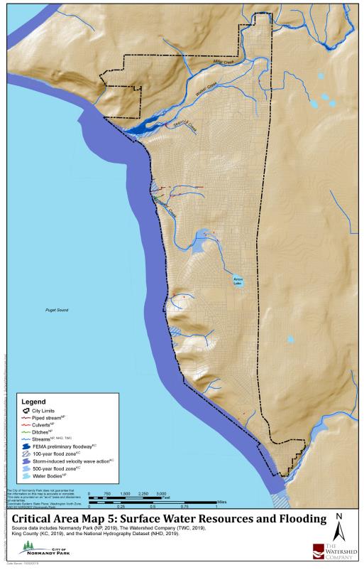
(2) Floodplain Habitat Assessment.
(a) When development is proposed within the regulatory floodplain, a floodplain habitat assessment shall be prepared pursuant to the requirements of NPMC 18.36.130 and 18.36.150.
(b) The floodplain habitat assessment shall address the effects of the development on federally listed salmon, including, but not limited to, the following:
(i) Impervious surfaces;
(ii) Floodplain storage and conveyance;
(iii) Floodplain and riparian vegetation; and
(iv) Stormwater drainage.
(c) If the floodplain habitat assessment concludes that the project is expected to have an adverse effect on listed species as evaluated under the guidance issued for ESA compliance under the National Flood Insurance Program in Puget Sound, the applicant shall mitigate those impacts. Such mitigation shall be consistent with, or in addition to, any mitigation required by critical area regulations in this chapter and shall be incorporated into the approved project plans.
(d) Activities Exempt from Floodplain Habitat Assessment. A floodplain habitat assessment is not required under the following circumstances:
(i) Projects that are undergoing or have undergone consultation with the National Marine Fisheries Service under the Endangered Species Act.
(ii) Repair or remodeling of an existing structure, if the repair or remodeling is not a substantial improvement.
(iii) Expansion of an existing structure that is no greater than 10 percent beyond its existing footprint; provided, that the repairs or remodeling is not a substantial improvement, or a repair of substantial damage. This measurement is counted cumulatively from September 22, 2011. If the structure is in the floodway, there shall be no change in the dimensions perpendicular to flow.
(iv) Activities with the sole purpose of creating, restoring, or enhancing natural functions provided the activities do not include structures, grading, fill, or impervious surfaces.
(v) Development of open space and recreational facilities, such as parks and trails, that do not include structures, fill, impervious surfaces or removal of more than five percent of the native vegetation on that portion of the property in the regulatory floodplain.
(vi) Repair to on-site septic systems provided the ground disturbance is the minimum necessary.
(vii) Other minor activities considered to have no effect on listed species, as interpreted using ESA guidance issued by the National Flood Insurance Program in Puget Sound and confirmed through city review of the development proposal. (Ord. 997 § 3 (Exh. B), 2019; Ord. 939 § 7, 2016; Ord. 825 § 3 (Exh. A), 2009).
Appendix A
Superseded by Ord. 839. (Ord. 825 § 3 (Exh. A), 2009).