


Chapter 14.15
OKANOGAN COUNTY SHORELINE MASTER PROGRAM
Sections:
Article I. Authority and Purpose
14.15.010 Shoreline Management Act.
14.15.050 Relationship to other codes and ordinances.
14.15.060 Liberal construction.
Article II. General Regulations
14.15.095 Compliance required.
14.15.100 Archaeological, cultural and historic resources.
14.15.110 Critical areas within shoreline jurisdiction.
14.15.120 Shoreline bulk and dimensional standards.
14.15.130 Vegetation conservation.
Article III. General Use Regulations
14.15.150 Accessory utilities.
14.15.180 Boating facilities (including docks, marinas, launches, moorage).
14.15.190 Bulkheads, breakwaters, jetties, groins, and weirs.
14.15.200 Clearing and grading.
14.15.210 Commercial uses and activities.
14.15.320 Residential development.
14.15.350 Shoreline stabilization.
14.15.360 Table 11 – Use and activity table.
Article IV. Shoreline Designation Regulations
14.15.370 Aquatic designation.
14.15.380 Conservancy designation.
14.15.390 Natural designation.
14.15.410 Shoreline residential designation.
14.15.420 Urban conservancy designation.
Article V. Administration
14.15.430 Minimum application requirements.
14.15.440 Preapplication conference.
14.15.450 Application review procedure.
14.15.460 Application vesting.
14.15.470 Notice of application.
14.15.480 Administrative review.
14.15.490 Notice of final decision.
14.15.500 Shoreline substantial development permits.
14.15.510 Exemptions from shoreline substantial development permit process.
14.15.520 Shoreline conditional use permits.
14.15.530 Shoreline variance review criteria.
14.15.550 Legal preexisting structures.
14.15.560 Legal preexisting uses.
14.15.570 Legal preexisting lots.
Article I. Authority and Purpose
14.15.010 Shoreline Management Act.
Washington State’s citizens voted to approve the Shoreline Management Act of 1971 in November 1972. The adoption of the Shoreline Management Act (Act) recognized “that the shorelines of the state are among the most valuable and fragile of its natural resources and that there is great concern throughout the state relating to their utilization, protection, restoration, and preservation” and that “coordinated planning is necessary in order to protect the public interest associated with the shorelines of the state while, at the same time, recognizing and protecting private property rights consistent with the public interest” (RCW 90.58.020). The Act seeks to foster all appropriate uses of the state’s shorelines; preserve and enhance priority uses, including shoreline public access, and provide opportunity for substantial numbers of people to enjoy the shorelines of the state, consistent with appropriate environmental protection.
Under the Act, shoreline master programs are created and implemented based on a “cooperative program of shoreline management between local government and the state” (RCW 90.58.050). The roles of local governments and the state are:
Local government shall have the primary responsibility for initiating the planning required by this chapter and administering the regulatory program consistent with the policy and provisions of this chapter. The department [of Ecology] shall act primarily in a supportive and review capacity with an emphasis on providing assistance to local government and on insuring compliance with the policy and provisions of this chapter. (RCW 90.58.050)
(Res. 36-2018 (Att. A), 2018).
14.15.020 Authority.
The Shoreline Management Act of 1971, Chapter 90.58 RCW, is the authority for the enactment and administration of this SMP. (Res. 36-2018 (Att. A), 2018).
14.15.030 Applicability.
A. Unless specifically exempted by statute, all proposed uses and development occurring within the shoreline jurisdiction must conform to Chapter 90.58 RCW, the Shoreline Management Act and this program whether or not a permit is required.
B. Shoreline permits administered by Okanogan County within the boundaries of the Colville Confederated Tribe shall be processed in accordance with CCT SMP Chapter 4-15.
C. The county has chosen not to exercise its option pursuant to RCW 90.58.030(2)(d)(ii) to increase shoreline jurisdiction to include buffer areas of critical areas within shorelines of the state. Therefore, as required by RCW 36.70A.480(6), for those designated critical area with buffers that extend beyond SMA jurisdiction, the critical area and its associated buffer shall continue to be regulated by the county’s critical area ordinance. In such cases, the updated SMP shall also continue to apply to the designated critical areas, but not the portion of the buffer areas that lies outside of SMA jurisdiction. All remaining designated critical areas (with buffers not extending beyond SMA jurisdiction) and their buffer areas shall be regulated solely by the SMP. (Res. 36-2018 (Att. A), 2018).
14.15.040 Purpose and intent.
The purposes of this SMP are to:
A. Promote the public health, safety, and general welfare of the community by providing comprehensive policies and effective, reasonable regulations for development and use and protection of Okanogan County shorelines; and
B. Recognize and protect private property rights; and
C. Nothing in these regulations shall constitute authority of any person to trespass or in any way infringe upon private property or upon the rights of private ownership as guaranteed by the U.S. and state constitutions, land deeds and abstracts.
D. Promote reasonable and appropriate use of the shorelines which will not jeopardize public and private interests; and
E. Protect rights of navigation; and
F. Preserve and protect fragile natural resources and culturally significant features; and
G. Increase public access to publicly owned areas of the shorelines where increased use levels are desirable; and
H. Manage shorelines in a positive, effective and equitable manner; and
I. Further assume and carry out the local government responsibilities established by the Act in RCW 90.58.050 including planning and administering the regulatory program consistent with the policy and provisions of the Act in RCW 90.58.020; and
J. To adopt and promote the following policy contained in RCW 90.58.020:
The legislature declares that the interest of all of the people shall be paramount in the management of shorelines of statewide significance. The department, in adopting guidelines for shorelines of statewide significance, and local government, in developing master programs for shorelines of statewide significance, shall give preference to uses in the following order of preference which:
(1) Recognize and protect the statewide interest over local interest;
(2) Preserve the natural character of the shoreline;
(3) Result in long-term over short-term benefit;
(4) Protect the resources and ecology of the shoreline;
(5) Increase public access to publicly owned areas of the shorelines;
(6) Increase recreational opportunities for the public in the shoreline;
(7) Provide for any other element as defined in RCW 90.58.100 deemed appropriate or necessary.
(Res. 36-2018 (Att. A), 2018).
14.15.050 Relationship to other codes and ordinances.
A. All applicable federal, state, and local laws shall apply to properties in the shoreline jurisdiction.
B. The goals and policies of this SMP approved under Chapter 90.58 RCW shall be considered an element of Okanogan County’s comprehensive plan. All other portions of this SMP, including use regulations, shall be considered a part of Okanogan County’s development regulations.
C. Where this program makes reference to any RCW, WAC, or other state or federal law or regulation, the most recent amendment or current edition shall apply. (Res. 36-2018 (Att. A), 2018).
14.15.060 Liberal construction.
As provided for in RCW 90.58.900, the Act is exempted from the rule of strict construction; the Act and this program shall be liberally construed to give full effect to the purposes, goals, objectives, and policies for which the Act and this program were enacted and adopted, respectively. (Res. 36-2018 (Att. A), 2018).
14.15.070 Severability.
Shall any chapter, section, subsection, paragraph, sentence, clause or phrase of this program be declared unconstitutional or invalid for any reason, such decision shall not affect the validity of the remaining portions of this program. (Res. 36-2018 (Att. A), 2018).
14.15.080 Effective date.
This program and all amendments thereto shall become effective 14 days after final approval by the Department of Ecology. (Res. 36-2018 (Att. A), 2018).
14.15.090 Definitions.
The definitions have been updated to include requirements from WAC 173-26-020 et seq., including definitions and general principles and governing principles in WAC 173-26-186. This chapter lists the official (legal) definitions of terms used in this SMP. As used in this SMP, unless the context requires otherwise, the following definitions and concepts apply:
A. “A” Definitions.
1. “Accessory building or use” means a subordinate building or use which is located on the same legal lot as the principal building or use.
2. “Act” means the Washington State Shoreline Management Act, Chapter 90.58 RCW.
3. “Administrative authority” shall, in the context of these regulations, mean the Okanogan County office of planning and development.
4. “Administrator” shall, in the context of this master program, mean the duly appointed representative of the county.
5. “Adoption by rule” means an official action by the Department to make a local government shoreline master program effective through rule consistent with the requirements of the Administrative Procedure Act, Chapter 34.05 RCW, thereby incorporating the adopted shoreline master program or amendment into the state master program.
6. “Agriculture” and “agricultural activities” means agricultural uses and practices including, but not limited to: producing, breeding, or increasing agricultural products; rotating and changing agricultural crops; allowing land used for agricultural activities to lie fallow in which it is plowed and tilled but left unseeded; allowing land used for agricultural activities to lie dormant as a result of adverse agricultural market conditions; allowing land used for agricultural activities to lie dormant because the land is enrolled in a local, state, or federal conservation program, or the land is subject to a conservation easement; conducting agricultural operations; maintaining, repairing, and replacing agricultural equipment; maintaining, repairing, and replacing agricultural facilities; provided, that the replacement facility is no closer to the shoreline than the original facility; and maintaining agricultural lands under production or cultivation.
7. “Agricultural equipment” and “agricultural facilities” include, but are not limited to:
a. The following used in agricultural operations: equipment; machinery; constructed shelters, buildings, and ponds; fences; upland finfish rearing facilities; water diversion, withdrawal, conveyance, and use equipment and facilities including, but not limited to, pumps, pipes, tapes, canals, ditches, and drains;
b. Corridors and facilities for transporting personnel, livestock, and equipment to, from, and within agricultural lands;
c. Farm residences and associated equipment, lands, and facilities; and
d. Roadside stands and on-farm markets for marketing fruit or vegetables.
8. “Agricultural land” means those specific land areas on which agriculture activities are conducted as of the date of adoption of a local master program pursuant to these guidelines as evidenced by aerial photography or other documentation. After the effective date of the master program, land converted to agricultural use is subject to compliance with the requirements of the master program.
9. “Agricultural products” includes, but is not limited to, horticultural, viticultural, floricultural, vegetable, fruit, berry, grain, hops, hay, straw, turf, sod, seed, and apiary products; feed or forage for livestock; Christmas trees; hybrid cottonwood and similar hardwood trees grown as crops and harvested within 20 years of planting; and livestock including both the animals themselves and animal products including, but not limited to, meat, upland finfish, poultry and poultry products, and dairy products.
10. “Amendment” means a revision, update, addition, deletion, and/or reenactment to an existing shoreline master program.
11. “Approval” means an official action by a local government legislative body agreeing to submit a proposed shoreline master program or amendments to the Department for review and official action pursuant to this chapter; or an official action by the Department to make a local government shoreline master program effective, thereby incorporating the approved shoreline master program or amendment into the state master program.
12. “Appurtenance” means development that is necessarily connected to the use and enjoyment of a single-family residence and is located landward of the OHWM and/or the perimeter of a wetland. Appurtenances include a garage, deck, driveway, utilities, fences, installation of a septic tank and drain field, swimming pools, hot tubs, saunas, landscaping retaining walls outside vegetation conservation areas, and grading which does not exceed 250 cubic yards and which does not involve placement of fill in any wetland or waterward of the ordinary high water mark.
13. “Aquaculture” means the culture or farming of fish, shellfish, or other aquatic plants and animals. Aquaculture does not include the harvest of wild geoduck associated with the state managed wildstock geoduck fishery.
14. “Archaeological resource/site” means archaeological and historic resources that are either recorded at the state historic preservation office and/or by local jurisdictions or have been inadvertently uncovered, are located on Okanogan County shorelands and including, but not limited to, submerged and submersible lands and the bed of the rivers within the state’s jurisdiction, that contains archaeological objects.
15. “Average grade level” means the average of the existing topography of the portion of the lot, parcel, or tract of real property which will be directly under the proposed building or structure; provided, that in the case of structures to be built over water, average grade level shall be the elevation of ordinary high water. Calculation of the average grade level shall be made by averaging the ground elevations at the center of all exterior walls of the proposed building or structure.
B. “B” Definitions.
1. “Best management practices” (BMPs) means conservation practices or systems of practices and management measures that:
a. Control soil loss and reduce water quality degradation caused by nutrients, animal waste, toxins, and sediment;
b. Minimize adverse impacts to surface water and groundwater flow, circulation pattern, and to the chemical, physical, and biological characteristics of waters, wetlands, and other fish and wildlife habitats;
c. Control site runoff, spillage or leaks, sludge or water disposal, or drainage from raw material.
2. “Boat launch ramp” means a structure constructed of concrete or other material, which extends waterward of the ordinary high water mark.
3. “Building” means any permanent structure built for the shelter or enclosure of persons, animals, chattels, or property of any kind and not including advertising signboards or fences.
4. “Bulkhead” means a solid wall erected generally parallel to and near the OHWM for the purpose of protecting adjacent uplands from waves or current action.
5. “Bulk storage” means nonportable storage of bulk products in fixed tanks.
C. “C” Definitions.
1. CAFO. As defined by 40 CFR 122.23.
2. “Channel migration zone (CMZ)” means the area along a river within which the channel(s) can be reasonably predicted to migrate over time as a result of natural and normally occurring hydrological and related processes when considered with the characteristics of the river and its surroundings. The CMZ is comprised of two areas defined as severe and moderate channel migration zones, which are delineated on maps maintained by Okanogan County. (Currently only maps for the Okanogan, Similkameen and Methow Rivers are available, and are attached as Appendix I to the resolution codified in this chapter).
a. Severe channel migration zones consist of the historic boundaries of channel migration; together with avulsion zones subject to rapid erosion during moderate to high streamflows; together with erosion expected within the next 50 years, measured from either the avulsion zones or the current stream channel (whichever is greater); less the area of potential channel migration limited by natural geologic features (such as a rock bluff); less the area of potential channel migration cut off by public infrastructure which is currently maintained.
b. Moderate channel migration zones consist of that portion of the 100-year horizontal floodplain, as defined by horizontal boundaries, which is outside the severe channel migration zone.
3. “City expansion area” means an area designated by the county, in consultation with the city or town, that already exhibits urban growth or where urban growth is to be encouraged.
4. “Clearing” means the destruction or removal of vegetation ground cover, shrubs and trees including, but not limited to, root material removal and/or topsoil removal.
5. “Commercial use” means facilities used or established to provide goods, merchandise or services for compensation or exchange, excluding facilities for the growth, production, or storage of agricultural products.
6. “Community boating facilities,” including docks, piers, ramps, marinas, etc., are typically designed and constructed to serve all or a significant component of the members of a residential development, which typically include waterfront property owners and often include nonwaterfront property owners.
7. “Conditional use” means a use, development, or substantial development which is classified as a conditional use or is not classified within the applicable master program.
8. “Comprehensive master program update” means a master program that fully achieves the procedural and substantive requirements of the Department’s shoreline master program guidelines effective January 17, 2004, as now or hereafter amended.
9. “Critical aquifer recharge areas” are areas with a critical recharging effect on aquifers used for potable water, including areas where an aquifer that is a source of drinking water is vulnerable to contamination that would affect the potability of the water, or is susceptible to reduced recharge.
10. Critical Areas.
a. “Critical areas” as defined under Chapter 36.70A RCW include the following areas and ecosystems: (1) wetlands; (2) areas with a critical recharging effect on aquifers used for potable waters; (3) fish and wildlife habitat conservation areas; (4) frequently flooded areas; and (5) geologically hazardous areas.
b. Critical areas on shorelines must meet the requirements of RCW 36.70A.480. Shorelines of the state shall not be considered critical areas under this chapter except to the extent that specific areas located within shorelines of the state qualify for critical area designation based on the definition of critical areas provided by RCW 36.70A.030(5) and have been designated as such by a local government pursuant to WAC 365-190-080.
D. “D” Definitions.
1. “Density” is an expression of the intensity of use of property, usually indicated in the following manner: For residential uses, the ratio of dwelling units per unit of land area or for other uses the number of equivalent uses per unit of land area.
2. “Development” means a use consisting of the construction or significant exterior alteration of structures; dredging; drilling; dumping; filling; removal of any sand, gravel, or minerals; bulkheading; driving of piling; placing of obstructions; or any project of a permanent or temporary nature which interferes with the normal public use of the surface of the waters of the state subject to Chapter 90.58 RCW at any stage of water level. (RCW 90.58.030(3)(d).)
3. “Development regulations” means the controls placed on development or land uses by Okanogan County, including, but not limited to, zoning ordinances, critical areas ordinances, all portions of a shoreline master program other than goals and policies approved or adopted under Chapter 90.58 RCW, planned unit development ordinances, subdivision ordinances, and binding site plan ordinances, together with any amendments thereto.
4. “Dike” means an artificial embankment or revetment normally set back from the bank or channel in the floodplain for the purpose of keeping floodwaters from inundating adjacent land.
5. “Dock” means all platform structures or anchored devices in or floating upon water bodies to provide moorage for pleasure craft or landing for water-dependent recreation including but not limited to floats, swim floats, float plane moorages, and water ski jumps. Excluded are boat launch ramps.
a. “Permanent dock” means a dock that is over 120 square feet, usually attached with pilings.
b. “Seasonal docks” means a dock up to 120 square feet so designed and constructed in order that it may be removed on a seasonal basis.
c. “Shared moorage facility” means dock facilities that would include joint use and/or community dock facilities.
6. “Document of record” means the most current shoreline master program officially approved or adopted by rule by the Department for a given local government jurisdiction, including any changes resulting from appeals filed pursuant to RCW 90.58.190.
7. “Dredge material disposal” means the disposal of material excavated waterward of the ordinary high water mark.
8. “Dredging” means the removal, displacement, and disposal of unconsolidated earth material such as silt, sand, gravel, or other submerged material from the bottom of water bodies or from wetlands.
9. “Dwelling, single-family” means a detached building containing one dwelling unit.
10. “Dwelling unit” means a building or portion thereof designed exclusively for residential purposes on a permanent basis; to be used, rented, leased, or hired out to be occupied for living purposes having independent living facilities, including permanent provisions for living, sleeping, eating, cooking, and sanitation. No motor home, travel trailer, tent trailer or other recreational vehicle shall be considered a dwelling unit.
E. “E” Definitions.
1. “Ecological functions” or “shoreline functions” means the work performed or role played by the physical, chemical, and biological processes that contribute to the maintenance of the aquatic and terrestrial environments that constitute the shoreline’s natural ecosystem. See WAC 173-26-201(2)(c).
2. “Ecosystem-wide processes” means the suite of naturally occurring physical and geologic processes of erosion, transport, and deposition; and specific chemical processes that shape landforms within a specific shoreline ecosystem and determine both the types of habitat and the associated ecological functions.
3. An “emergency” is an unanticipated and imminent threat to public health, safety, or the environment which requires immediate action within a time too short to allow full compliance with this chapter.
4. “Emergency construction” is construed narrowly as that which is necessary to protect property from the elements (RCW 90.58.030(3)(e)(iii)).
5. “Erosion hazard areas” are those areas containing soils which, according to the United States Department of Agriculture Natural Resources Conservation Service Soil Survey Program, may experience significant erosion. Erosion hazard areas also include channel migration zones.
6. “Exempt substantial developments” are those set forth in WAC 173-27-040 and RCW 90.58.030(3)(e), 90.58.140(9), 90.58.147, 90.58.355, and 90.58.515 which are not required to obtain a substantial development permit but which must otherwise comply with applicable provisions of the Act and the local master program.
7. “Experimental aquaculture” means an aquaculture project that uses methods or technologies that are unprecedented or unproven in the state of Washington.
F. “F” Definitions.
1. “Fair market value” of a development is the open market bid price for conducting the work, using the equipment and facilities, and purchase of the goods, services and materials necessary to accomplish the development. This would normally equate to the cost of hiring a contractor to undertake the development from start to finish, including the cost of labor, materials, equipment and facility usage, transportation and contractor overhead and profit. The fair market value of the development shall include the fair market value of any donated, contributed or found labor, equipment or materials (WAC 173-27-030(8)).
2. “Feasible” means, for the purpose of this chapter, that an action, such as a development project, mitigation, or preservation requirement, meets all of the following conditions:
a. The action can be accomplished with technologies and methods that have been used in the past in similar circumstances, or studies or tests have demonstrated in similar circumstances that such approaches are currently available and likely to achieve the intended results;
b. The action provides a reasonable likelihood of achieving its intended purpose; and
c. The action does not physically preclude achieving the project’s primary intended legal use. In cases where this SMP requires certain actions unless they are infeasible, the burden of proving infeasibility is on the applicant. In determining an action’s infeasibility, the local or tribal government reviewing the application may weigh the action’s relative public costs and public benefits, considered in the short- and long-term time frames.
3. “Feedlot” means an enclosure or facility used or capable of being used for feeding livestock hay, grain, silage, or other livestock feed, but shall not include land for growing crops or vegetation for livestock feeding and/or grazing, nor shall it include normal livestock wintering.
4. “Fill” means the addition of soil, sand, rock, gravel, sediment, earth retaining structure, or other material to an area waterward of the OHWM, in wetlands, or on shorelands in a manner that raises the elevation or creates dry land.
5. “Fish and wildlife habitat conservation areas” are areas that serve a critical role in sustaining needed habitats and species for the functional integrity of the ecosystem, and which, if altered, may reduce the likelihood that the species will persist over the long term. These areas may include, but are not limited to, rare or vulnerable ecological systems, communities, and habitat or habitat elements including seasonal ranges, breeding habitat, winter range, and movement corridors; and areas with high relative population density or species richness.
6. “Floating home” means a structure designed and operated substantially as a permanently based overwater residence. Floating homes are not vessels and typically lack adequate self-propulsion and steering equipment to operate as a vessel. They are typically served by permanent utilities and semi-permanent anchorage/moorage facilities.
7. “Float” means a detached, anchored structure that is free to rise and fall with water levels including any floating, anchored platform or similar structure, used for boat mooring, swimming or similar recreational activities that is not anchored or accessed directly from the shoreline.
8. “Floodplain” is synonymous with “100-year floodplain” and means that land area susceptible to inundation with a one percent chance of being equaled or exceeded in any given year. The limit of this area shall be based upon Federal Emergency Management Agency (FEMA) flood insurance rate maps (FIRM maps).
9. “Floodway” means the channel of a river or other watercourse and the adjacent land areas that must be reserved in order to discharge the base flood without cumulatively increasing the water surface elevation more than a designated height.
10. “Forest practices” means any activity conducted on or directly pertaining to forest land and associated with such activities as growing, harvesting, or processing timber, including but not limited to: road and trail construction, harvesting, final and intermediate, precommercial thinning, reforestation, fertilization, prevention and suppression of diseases and insects, salvage of trees, and brush control. “Forest practice” shall not include: forest species seed orchard operations and intensive forest nursery operations; or preparatory work such as tree marking, surveying and road flagging; or removal or harvest of incidental vegetation from forest lands such as berries, ferns, greenery, mistletoe, herbs, mushrooms, and other products which cannot normally be expected to result in damage to forest soils, timber or public resources.
11. “Frequently flooded areas” are lands in the floodplain subject to at least a one percent or greater chance of flooding in any given year, or within areas subject to flooding due to high groundwater. These areas include, but are not limited to, streams, rivers, lakes, wetlands, and areas where high groundwater forms ponds on the ground surface.
12. “Frontage” is the distance measured along the ordinary high water mark.
G. “G” Definitions.
1. “Geologically hazardous areas” are areas that, because of their susceptibility to erosion, sliding, earthquake, or other geological events, are not suited to siting commercial, residential, or industrial development consistent with public health or safety concerns. Any areas meeting the definition of “geologically hazardous areas” include the following:
a. Erosion hazard areas: areas containing soils which, according to the United States Department of Agriculture Natural Resources Conservation Service Soil Survey Program, may experience significant erosion. Erosion hazard areas also include coastal erosion-prone areas and channel migration zones.
b. Landslide hazard areas: areas that have the potential of risk of mass movement resulting from a combination of geologic, topographic, and hydrologic factors; they include any areas susceptible to landslide because of any combination of bedrock, soil, slope (gradient), slope aspect, structure, hydrology, or other factors, and include, at a minimum, the following:
(1) Areas of historic failures, such as:
(A) Those areas delineated by the United States Department of Agriculture Natural Resources Conservation Service as having a significant limitation for building site development;
(B) Areas designated as quaternary slumps, earthflows, mudflows, lahars, or landslides on maps published by the United States Geological Survey or Washington Department of Natural Resources;
(2) Areas with all three of the following characteristics:
(A) Slopes steeper than 15 percent;
(B) Hillsides intersecting geologic contacts with a relatively permeable sediment overlying a relatively impermeable sediment or bedrock; and
(C) Springs or groundwater seepage;
(3) Areas that have shown movement during the Holocene Epoch (from 10,000 years ago to the present) or which are underlain or covered by mass wastage debris of this epoch;
(4) Slopes that are parallel or subparallel to planes of weakness (such as bedding planes, joint systems, and fault planes) in subsurface materials;
(5) Slopes having gradients steeper than 80 percent subject to rock fall during seismic shaking;
(6) Areas potentially unstable as a result of rapid stream incision, stream bank erosion, and undercutting by wave action, including stream channel migration zones;
(7) Areas that show evidence of, or are at risk from, snow avalanches;
(8) Areas located in a canyon or on an active alluvial fan, presently or potentially subject to inundation by debris flows or catastrophic flooding; and
(9) Any area with a slope of 40 percent or steeper and with a vertical relief of 10 or more feet except areas composed of bedrock. A slope is delineated by establishing its toe and top and measured by averaging the inclination over at least 10 feet of vertical relief.
c. Seismic hazard areas: areas that are subject to severe risk of damage as a result of earthquake-induced ground shaking, slope failure, settlement, or soil liquefaction; seismic hazard areas must include areas subject to severe risk of damage as a result of earthquake-induced ground shaking, slope failure, settlement or subsidence, soil liquefaction or surface faulting. Settlement and soil liquefaction conditions occur in areas underlain by cohesionless soils of low density, typically in association with a shallow groundwater table. One indicator of potential for future earthquake damage is a record of earthquake damage in the past. Ground shaking is the primary cause of earthquake damage in Washington, and ground settlement may occur with shaking. The strength of ground shaking is primarily affected by:
(1) The magnitude of the earthquake;
(2) The distance from the source of an earthquake;
(3) The type or thickness of geologic materials at the surface; and
(4) The type of subsurface geologic structure.
d. Mine hazard areas: areas that are directly underlain by, adjacent to, or affected by mine workings such as adits, tunnels, drifts, or air shafts.
e. Volcanic hazard areas: areas subject to pyroclastic flows, lava flows, and inundation by debris flows, mud flows, or related flooding resulting from volcanic activity.
2. “Geotechnical report” or “geotechnical analysis” means a scientific study or evaluation conducted by a qualified expert that includes a description of the ground and surface hydrology and geology, the affected land form and its susceptibility to mass wasting, erosion, and other geologic hazards or processes, conclusions and recommendations regarding the effect of the proposed development on geologic conditions, the adequacy of the site to be developed, the impacts of the proposed development, alternative approaches to the proposed development, and measures to mitigate potential site-specific and cumulative geological and hydrological impacts of the proposed development, including the potential adverse impacts to adjacent and down-current properties. Geotechnical reports shall conform to accepted technical standards and must be prepared by qualified professional engineers or geologists who have professional expertise about the regional and local shoreline geology and processes.
3. “Grading” means the movement or redistribution of the soil, sand, rock, gravel, sediment, or other material on a site in a manner that alters the natural contour of the land.
4. “Guidelines” means those standards adopted by the Department to implement the policy of Chapter 90.58 RCW for regulation of use of the shorelines of the state prior to adoption of master programs. Such standards shall also provide criteria for local governments and the Department in developing and amending master programs.
H. “H” Definitions.
1. “Habitat” means the specific area or environment in which a particular type of plant or animal lives.
2. “Hard shoreline stabilization” means shore erosion control practices using hardened structures that armor and stabilize the shoreline landward of the structure from further erosion including, but not limited to, bulkheads, rip-rap, jetties, groins, breakwaters, and stone reinforcement.
3. “Height, building” is measured from average grade level to the highest point of a structure; provided, that television antennas, chimneys, and similar appurtenances shall not be used in calculating height, except where such appurtenances obstruct the view of the shoreline of a substantial number of residences on areas adjoining such shorelines, or this master program specifically requires that such appurtenances be included; provided further, that temporary construction equipment is excluded in this calculation.
4. “Historic site” means those sites that are eligible or listed on the Washington Heritage Register, National Register of Historic Places, or any locally developed historic registry formally adopted by Okanogan County.
5. “Houseboat” means a vessel principally used as an overwater residence. Houseboats are licensed and designed for use as mobile structures with detachable utilities or facilities, anchoring and the presence of adequate self-propulsion and steering equipment to operate as a vessel. “Principal use as an overwater residence” means the occupant resides on the vessel in a specific location, and/or in the same area on more than a total of 30 days in any 40-day period or on more than a total of 90 days in any 365-day period. “In the same area” means within a radius of one mile of any location where the same vessel previously moored or anchored on state-owned aquatic lands. This definition includes liveaboard vessels.
I. “I” Definitions.
1. “Industrial use” means a use including manufacturing, processing, warehousing, storage, distribution, shipping and other related uses.
2. “In-stream structure” means a structure placed by humans within a stream or river waterward of the ordinary high water mark that either causes or has the potential to cause water impoundment or the diversion, obstruction, or modification of water flow. In-stream structures may include those for hydroelectric generation, irrigation, water supply, flood control, transportation, utility service transmission, fish habitat enhancement, or other purpose.
J. “J” Definitions. Reserved.
K. “K” Definitions. Reserved.
L. “L” Definitions.
1. Landfill. See “fill.”
2. “Land use, high-impact” or “high-intensity land use” means land use that includes the following uses or activities: commercial, urban, industrial, institutional, retail sales, residential (more than one unit/acre), high-intensity new agriculture (dairies, nurseries, greenhouses, raising and harvesting crops requiring annual tilling, raising and maintaining animals), high-intensity recreation (golf courses, ball fields), and hobby farms.
3. “Land use, low-impact” means land use that includes the following uses or activities: forestry (cutting of trees only), low-intensity open space (hiking, bird-watching, preservation of natural resources, etc.), unpaved trails, utility corridor without a maintenance road and little or no vegetation management.
4. “Land use, medium-impact” means land use that includes the following uses or activities: residential (one unit per acre or less), moderate-intensity open space (parks with biking, jogging, etc.), conversion to moderate-intensity agriculture (orchards, hay fields, etc.), paved trails, building of logging roads, utility corridor or right-of-way shared by several utilities and including access/maintenance road.
5. “Large woody debris” or “LWD” means all wood greater than four inches in diameter naturally occurring or artificially placed in streams, including branches, stumps, logs and logjams.
6. “Legal preexisting lot” means a lot which was created prior to the adoption, revision, or amendment of the SMP, but which fails, by reason of such adoption, revision or amendment, to conform to the current requirements of the SMP.
7. “Legal preexisting structure” means a building or structure which was existing prior to the adoption, revision, or amendment of the SMP, but which fails, by reason of such adoption, revision or amendment, to conform to the current requirements of the SMP.
8. “Legal preexisting use” means a use of the land which was lawful prior to the adoption, revision, or amendment of the SMP, but which fails, by reason of such adoption, revision, or amendment, to conform to the current requirements of the SMP.
9. “Limited master program amendment” means a master program amendment that addresses specific procedural and/or substantive topics and which is not intended to meet the complete requirements of a comprehensive master program update.
10. “Litter container” means a container provided on public or private property for temporary disposal of wastepaper, used beverage or food containers, and other small articles of rubbish, trash, or garbage by users of the site. Every litter container shall be closed with a well-fitting lid or designed to reasonably prevent its contents from becoming litter.
11. “Local government” means Okanogan County.
12. “Lot coverage” is the percentage of that portion of a parcel within shoreline jurisdiction, less the required vegetation conservation area, to be covered with impervious surfaces.
13. Lot of Record. For the purposes of this plan, a “lot of record” shall be any parcel created prior to the adoption of this plan or parcels created after the adoption of this plan consistent with Okanogan County subdivision regulations.
M. “M” Definitions.
1. “May” means an action is acceptable, provided it conforms to the provisions of this SMP.
2. “Marina” means a commercial facility which provides boat launching, storage, supplies and services for small pleasure craft. There are two basic types of marinas: open type construction (floating breakwater and/or open pile work) and solid type construction (bulkhead and/or landfill).
3. “Mineral extraction” means the removal of topsoil, gravel, rock, clay, sand or other earth material, including accessory activities such as washing, sorting, screening, crushing and stockpiling. Not included is the leveling, grading, filling, or removal of materials during the course of normal site preparation for an approved use (e.g., residential subdivision, commercial development, etc.) subject to the provisions of this program.
4. “Mineral prospecting” means to excavate, process, or classify aggregate using handheld mineral prospecting tools and mineral prospecting equipment.
5. “Mining” means the act of extracting of sand, gravel, soil, minerals, and other earth materials for commercial and other uses.
6. “Mitigation (sequencing)” means the use of any or all of the following actions that are listed in descending order of preference:
a. Avoiding the impact altogether by not taking a certain action or parts of an action;
b. Minimizing impacts by limiting the degree or magnitude of the action and its implementation, by using appropriate technology, or by taking affirmative steps to avoid or reduce impacts;
c. Rectifying the impact by repairing, rehabilitating or restoring the affected sensitive area;
d. Reducing or eliminating the impact over time by preservation or maintenance operations during the life of the development proposal;
e. Compensating for the impact by replacing, enhancing or providing substitute sensitive areas and environments;
f. Monitoring the impact and taking appropriate corrective measures.
7. “Mixed-use development” means a combination of uses within the same building. Mixed-use developments, which incorporate non-water-oriented uses, must include water-dependent use(s), except commercial uses complying with WAC 173-26-241(3)(d).
8. “Monitoring” means evaluating the impacts of development on the environment (which may include biology, geology, hydrology, hydraulics, and other factors related to safety and shoreline ecological function) and determining how well any required mitigation measures are functioning through the monitoring period. Monitoring may also include collection and analysis of data by various methods for the purpose of understanding and documenting changes in natural ecosystems and features; and does also include gathering baseline data.
9. “Multifamily dwelling (residence)” means a single building, or portion thereof, designed for or occupied by three or more families living independently of each other in separate dwelling units on one legal lot of record and, for the purpose of this code, includes triplexes, fourplexes, apartment buildings, and residential condominiums.
10. “Municipal uses” are those in support of local government functions and services. For the purposes of this SMP, recreational uses and utility facilities are excluded.
11. “Must” means an action is required.
N. “N” Definitions.
1. “Natural or existing topography” means the topography of the lot, parcel, or tract of real property immediately prior to any site preparation or grading, including excavation or filling.
2. “Navigable waters of the United States,” for purposes of this plan, means a water body that in its ordinary condition, or by being united with other water bodies, forms a continuous route over which commerce is or may be carried on with other states or foreign countries in the customary modes in which such commerce is conducted by water.
3. “No net loss of ecological functions” means a public policy goal and requirement to maintain the aggregate total of the county’s shoreline ecological functions at its current level. As a development standard, it means the result of the application of mitigation sequencing, in which impacts of a particular shoreline development and/or use, whether permitted or exempt, are identified and addressed, such that there are no adverse impacts on shoreline ecological functions or processes relative to the legal condition just prior to the proposed development and/or use.
4. “Nonstructural shoreline stabilization” includes building setbacks, and planning and regulatory measures to avoid the need for structural stabilization, vegetation stabilization and bioengineered stabilization.
5. “Non-water-oriented use” means a use that is not a water-dependent, water-related, or water-enjoyment use.
O. “O” Definitions.
1. “Office of Financial Management” means the Office of Financial Management of the state of Washington.
2. “Official map of shorelines” means all maps adopted as part of this master program delineating the approximate geographic boundaries of all designated water bodies of Okanogan County, coming under the jurisdiction of the Shoreline Management Act of 1971. Streams and lakes are naturally fluctuating systems and are not static; therefore, the actual boundaries of the shoreline jurisdiction are determined on the ground at the time of application using the definition of “shoreline jurisdiction” found in RCW 90.58.030(2).
3. “Open space, common” means land within or related to a development, not individually owned (undivided interest), which remains undeveloped (except for approved trails and accessory structures as allowed by this SMP and approved by the Department of Fish and Wildlife) and that is dedicated to one or more of the following purposes: historical/architectural preservation and/or wildlife habitat and/or recreation.
4. “Open space, conservation” means land retained in an open or unimproved condition, which has been set aside, dedicated, designated, or reserved for fish and wildlife preservation or enhancement purposes. Mechanisms for preservation of conservation open space include but are not limited to: subdivision, planned development (PD), or planned destination resort (PDR) process. Lands within this type of an open space dedication may include portions and combinations of forest, agricultural and grazing lands, priority fish and wildlife habitats, on-site watersheds, 100-year floodplains, county shorelines or shorelines of statewide significance and riparian areas and wetlands. Land so designated shall not include areas of human impact and shall contain no structures or impervious surfaces other than those which are approved by the administrator, e.g., part of an organized trail system, structure approved by the Department of Fish and Wildlife, and structures of historical/architectural preservation significance or used as designated conservation open space.
5. “Open space, individual ownership” means land within or related to a development owned individually, which remains undeveloped (except for trails) and that is dedicated for use in the development and is retained or restored to its native state or used for agricultural or recreational purposes as allowed by this SMP, e.g., part of an organized trail system, structure approved by the Department of Fish and Wildlife, and structures of historical/architectural preservation significance or used as designated wildlife open space.
6. “Open space, public” means any land which has been acquired, set aside, dedicated, designated or reserved for general public use or enjoyment.
7. “Ordinary high water mark” on all lakes and streams is that mark that will be found by examining the bed and banks and ascertaining where the presence and action of waters are so common and usual, and so long continued in all ordinary years, as to mark upon the soil a character distinct from that of the abutting upland, in respect to vegetation as that condition existed on June 1, 1971, as it may naturally change thereafter, or as it may change thereafter in accordance with permits issued by a local government or the Department of Ecology. The following criteria clarify this mark on lakes and streams:
a. Lakes. Where the ordinary high water mark cannot be found, it shall be the line of mean high water.
b. Streams. Where the ordinary high water mark cannot be found, it shall be the line of mean high water. For braided streams, the ordinary high water mark is found on the banks forming the outer limits of the depression within which the braiding occurs.
8. “Overwater structure” means any structure located waterward of the OHWM. Common examples include, but are not limited to, residential piers, marinas, and bridges.
P. “P” Definitions.
1. “Party of record” includes all persons, agencies or organizations who have submitted written comments in response to a notice of application; made oral comments in a formal public hearing conducted on the application; or notified local government of their desire to receive a copy of the final decision on a permit and who have provided an address for delivery of such notice by mail;
2. “Permit” means any substantial development, variance, conditional use permit, or revision authorized under Chapter 90.58 RCW;
3. “Person” means an individual, partnership, corporation, association, organization, cooperative, public or municipal corporation, or agency of the state or local governmental unit however designated.
4. “Placer mining” means the mining (by panning or dredging) of alluvial (waterborne) or glacial deposits of precious metals or minerals, usually in stream beds or valleys adjacent to uplands rich in these minerals.
5. “Pier” means a fixed platform above the water, perpendicular to the shoreline.
6. “Primary utilities” are transmission, collection, production, or treatment facilities that are generally regional or areawide in scope and provide the primary service to a large area and may or may not be connected directly to the uses along the shoreline. Utilities include primary transmission facilities related to hydropower, communications, and distribution or collection systems for water, sewer mains, gas and oil pipelines, and wastewater and water treatment plants.
7. “Priority habitat” means a habitat type with unique or significant value to one or more species. An area classified and mapped as priority habitat must have one or more of the following attributes:
a. Comparatively high fish or wildlife density;
b. Comparatively high fish or wildlife species diversity;
c. Fish spawning habitat;
d. Important wildlife habitat;
e. Important fish or wildlife seasonal range;
f. Important fish or wildlife movement corridor;
g. Rearing and foraging habitat;
h. Important marine mammal haul-out;
i. Refugia habitat;
j. Limited availability;
k. High vulnerability to habitat alteration;
l. Unique or dependent species; or
m. Shellfish bed.
A priority habitat may be described by a unique vegetation type or by a dominant plant species that is of primary importance to fish and wildlife (such as oak woodlands or eelgrass meadows). A priority habitat may also be described by a successional stage (such as old growth and mature forests). Alternatively, a priority habitat may consist of a specific habitat element (such as a consolidated marine/estuarine shoreline, talus slopes, caves, snags) of key value to fish and wildlife. A priority habitat may contain priority and/or nonpriority fish and wildlife.
8. “Priority species” means a species requiring protective measures and/or management guidelines to ensure its persistence at genetically viable population levels. Priority species are those that meet any of the criteria listed below.
a. Criterion 1 – State-Listed or State Proposed Species. State-listed species are those native fish and wildlife species legally designated as endangered (WAC 232-12-014), threatened (WAC 232-12-011), or sensitive (WAC 232-12-011). State proposed species are those fish and wildlife species that will be reviewed by the Department of Fish and Wildlife (POL-M-6001) for possible listing as endangered, threatened, or sensitive according to the process and criteria defined in WAC 232-12-297.
b. Criterion 2 – Vulnerable Aggregations. Vulnerable aggregations include those species or groups of animals susceptible to significant population declines, within a specific area or statewide, by virtue of their inclination to congregate. Examples include heron colonies, seabird concentrations, and marine mammal congregations.
c. Criterion 3 – Species of Recreational, Commercial, and/or Tribal Importance. Native and nonnative fish, shellfish, and wildlife species of recreational or commercial importance and recognized species used for tribal ceremonial and subsistence purposes that are vulnerable to habitat loss or degradation.
d. Criterion 4. Species listed under the federal Endangered Species Act as either proposed, threatened, or endangered.
9. “Provisions” means policies, regulations, standards, guideline criteria or environment designations.
10. “Public access” means the public’s right to get to and use the state’s public waters, the water/land interface and associated shoreline area. It includes physical access that is either lateral (areas paralleling the shore) or perpendicular (an easement or public corridor to the shore), and/or visual access facilitated by means such as scenic roads and overlooks, viewing towers and other public sites or facilities.
11. “Public access, community” means the right of all property owners or members of a residential development to get to and use the state’s public waters, the water/land interface and associated shoreline area. It includes physical access that is either lateral (areas paralleling the shore) or perpendicular (an easement or community corridor to the shore), and/or visual access facilitated by scenic roads and overlooks, viewing towers and other community sites or facilities. Community access is not intended for the general public.
Q. “Q” Definitions.
1. “Qualified professional” means a person with experience and training in the pertinent scientific discipline, and who is a qualified scientific expert with expertise appropriate for the relevant conservation area subject in accordance with WAC 365-195-905(4). A qualified professional will have obtained a B.S. or B.A. or equivalent degree in biology, engineering, environmental studies, fisheries, geomorphology or related field, and have at least two years of related work experience. A geologist must have a state license.
R. “R” Definitions.
1. “Recreation, low-intensity” means recreation that does not require developed facilities other than unimproved trails and can be accommodated without change to the area or resource other than development of trails and placement of litter containers and directional and interpretive signs. Examples are hiking, shore fishing, and bicycling.
2. “Recreation, high-intensity” means uses with specially built facilities, or occurs in such density or form that it requires or results in a modification of the area of resource. Campgrounds, golf courses, public beaches, and marinas are examples of high-intensity recreation.
3. “Recreational development” means the modification of the natural or existing environment to accommodate recreation. This includes commercial and public facilities designed and used to provide recreational opportunities to the public.
4. “Recreational uses” means uses which offer activities, pastimes, and experiences that allow for the refreshment of mind and body. Examples include, but are not limited to, parks, camps, camping clubs, launch ramps, golf courses, viewpoints, trails, public access facilities, public parks and athletic fields, hunting blinds, and other low-intensity-use outdoor recreation areas. Recreational uses that do not require a shoreline location, nor are related to the water, nor provide significant public access are considered non-water-oriented. For example, a recreation use solely offering indoor activities would be considered non-water-oriented.
5. “Recreational vehicle (RV) park” means a tract of land developed with individual sites for rent and containing roads and utilities to accommodate recreational vehicles or tent campers for vacation or other similar short stay purposes.
6. “Residential development” means one or more buildings, structures or portions thereof that are designed and used as a place for human habitation. Included are single, duplex or multifamily dwellings, apartment/condominium buildings, mobile homes, short/long subdivisions of land and other structures that serve to house people.
7. “Responsible official” shall mean the director of planning for Okanogan County.
8. “Restore,” “restoration” or “ecological restoration” means the reestablishment or upgrading of impaired ecological shoreline processes or functions. This may be accomplished through measures including, but not limited to, revegetation, removal of intrusive shoreline structures and removal or treatment of toxic materials. Restoration does not imply a requirement for returning the shoreline area to aboriginal or pre-European settlement conditions.
9. “Riparian areas” are transitional between terrestrial and aquatic ecosystems and are distinguished by gradients in biophysical conditions, ecological processes, and biota. They are areas through which surface and subsurface hydrology connect water bodies with their adjacent uplands. They include those portions of terrestrial ecosystems that significantly influence exchanges of energy and matter with aquatic ecosystems (i.e., a zone of influence). Riparian areas are adjacent to perennial, intermittent, and ephemeral streams, lakes, and estuarine-marine shorelines.
10. “Riprap” means broken stone or other hardening material placed along the shoreline of a lake, river, or stream to prevent erosion or provide stability.
S. “S” Definitions.
1. “Sanitary landfill” means a disposal facility or part of a facility at which solid waste is permanently placed in or on land and which is not a land spreading disposal facility.
2. “Seasonal” means a temporary use the duration of which is related to an identifiable climatic, cultural, or recreational period (i.e., summer, winter, fall, spring, Christmas, ski season).
3. “Setback” means the required minimum distance between the ordinary high water mark or, where relevant, any other lot or property line, and the outermost vertical plane of any building, structure, device, fence, swimming pool, landscaped or graded area, or other improvement causing a disturbance to the natural landscape.
4. “Shall” means a mandate; the action must be done.
5. Shoreline Areas. See “shoreline jurisdiction.”
6. “Shoreline administrator” means the director of the planning and development department or staff member designated by the director to perform and review functions required in this program.
7. “Shorelines” means all of the water areas of the state, including reservoirs, and their associated shorelands, together with the lands underlying them, except:
a. Shorelines of statewide significance;
b. Shorelines on segments of streams upstream of a point where the mean annual flow is 20 cubic feet per second or less and the wetlands associated with such upstream segments; and
c. Shorelines on lakes less than 20 acres in size and wetlands associated with such small lakes.
8. Shoreline Ecological Function. See “ecological functions.”
9. “Shoreline frontage” means the land that lies adjacent to the lake, river, or stream subject to this program.
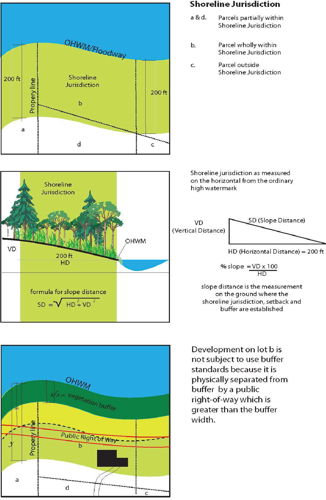
10. “Shoreline jurisdiction” or “shoreline area” means all “shorelines of the state” and “shorelands” as defined in RCW 90.58.030. The county regulates floodplains outside of the described shoreline area under its county codes and does not extend its shoreline jurisdictional boundary to include the flood hazard regulations beyond the defined shoreline area in WAC 173-26-020(33).
11. “Shoreline master program” or “SMP” means the comprehensive use plan for the shoreline area of a jurisdiction subject to this title, and the use regulations together with maps, diagrams, charts, or other descriptive material and text, a statement of desired goals, and standards developed in accordance with the policies enunciated in Chapter 90.58 RCW;
12. “Shoreline modifications” means those actions that modify the physical configuration or qualities of the shoreline area, usually through the construction of a physical element such as a dike, breakwater, pier, weir, dredged basin, fill, bulkhead, or other shoreline structure. They can include other actions, such as clearing, grading, or application of chemicals.
13. “Shoreline permit” means a shoreline substantial development permit, a shoreline conditional use, or a shoreline variance, or any combination thereof issued by Okanogan County, pursuant to Chapter 90.58 RCW.
14. “Shorelines of the state” are the total of all “shorelines” and “shorelines of statewide significance” within the state.
15. “Shorelines of statewide significance” in Okanogan County means:
a. Those lakes, whether natural, artificial or a combination thereof with a surface acreage of 1,000 acres or more measured from the ordinary high water mark.
b. Those natural rivers or segments thereof that are downstream of a point where the mean annual flow is measured at 200 cubic feet per second or more, or those portions of rivers downstream from the first 300 square miles of drainage area, whichever is longer.
c. Those shorelands associated with such water bodies.
16. “Should” means that the particular action is required unless there is a demonstrated, compelling reason, based on policy of the Shoreline Management Act and this chapter, against taking the action.
17. “Significant vegetation removal” means the removal or alteration of trees, shrubs, and/or ground cover by clearing, grading, cutting, burning, chemical means, or other activity that causes significant ecological impacts to functions provided by such vegetation. The removal of invasive or noxious weeds does not constitute significant vegetation removal. Tree pruning, not including tree topping, where it does not affect ecological functions, does not constitute significant vegetation removal.
18. “Soft shoreline stabilization” means shore erosion control and restoration practices using only plantings or organic materials to restore, protect or enhance the natural shoreline environment.
19. “Solid waste” means all putrescible and nonputrescible solid and semisolid wastes, including but not limited to garbage, rubbish, ashes, industrial wastes, swill, demolition and construction wastes, abandoned vehicles or parts thereof, and discarded commodities. This includes all liquid, solid and semisolid, materials which are not the primary products of public, private, industrial, commercial, mining, and agricultural operations. Solid waste includes but is not limited to sludge from wastewater treatment plants and septage from septic tanks, wood waste, dangerous waste, and problem wastes.
20. “State master program” means the cumulative total of all shoreline master programs and amendments thereto approved or adopted by rule by the Department.
21. “Structural shoreline stabilization” means shore erosion control practices using hardened structures that armor and stabilize the shoreline landward of the structure from further erosion; examples include bulkheads, concrete walls, rip-rap, jetties, groins, breakwaters, stone reinforcement.
22. “Structure” means anything constructed in the ground, or anything erected which requires location on the ground or water, or is attached to something having location on or in the ground, but not including fences or paved areas, or standard roof-mounted antennas.
23. “Subdivision” means a division or redivision of land into five or more lots, tracts, parcels, sites or divisions for the purpose of sale, lease or transfer of ownership including any remaining portions of the parent parcel.
24. “Substantial accessory use facilities” means substantial accessories including but not limited to restrooms, recreation halls and gymnasiums, commercial services, access roads, and parking areas associated with recreational development.
25. “Substantial development” shall mean any development of which the total cost or fair market value exceeds $6,416 or the dollar value as amended by the State of Washington Office of Financial Management, or any development which materially interferes with the normal public use of the water or shorelines of the state. The dollar threshold established in this definition must be adjusted for inflation by the Office of Financial Management every five years, beginning July 1, 2007, based upon changes in the Consumer Price Index during that time period.
26. “Substantially degrade” means cause significant ecological impact.
T. “T” Definitions.
1. “Temporary” means having a specific, short-term duration. (See “seasonal.”)
2. “Temporary sign” means a sign not intended to be permanently installed.
3. “Temporary use” means a use that is limited in scope, duration, and frequency.
U. “U” Definitions.
1. “Upland,” when used as an adjective, means outside of the shoreline area.
2. “Uplands” means those lands outside of the shoreline area and not under shoreline jurisdiction.
3. “Use” means the purpose for which land or a structure is primarily designed, arranged or intended, or for which it is primarily occupied or maintained.
V. “V” Definitions.
1. “Variance” is a means to grant relief from the specific bulk, dimensional or performance standards set forth in this master program.
2. “Vegetation conservation areas” include areas adjacent to shorelines as specified in OCC 14.15.120(E) to protect and restore vegetation that contributes to the ecological functioning of shoreline areas. Vegetation conservation areas include the prevention or restriction of plant clearing and earth grading, vegetation restoration, and the control of invasive weeds and nonnative species.
3. Visual Public Access. See “public access.”
W. “W” Definitions.
1. “Water-dependent use” means a use or portion of a use which cannot exist in a location that is not adjacent to the water and which is dependent on the water by reason of the intrinsic nature of its operations.
2. “Water-oriented use” means any one or a combination of water-dependent, water-related or water-enjoyment uses.
3. “Water quality” means the physical characteristics of water within shoreline jurisdiction, including water quantity, hydrological, physical, chemical, aesthetic, recreation-related, and biological characteristics. Where used in this chapter, the term “water quantity” refers only to development and uses regulated under this chapter and affecting water quantity, such as impermeable surfaces and storm water handling practices. Water quantity, for purposes of this chapter, does not mean the withdrawal of groundwater or diversion of surface water pursuant to RCW 90.03.250 through 90.03.340.
4. “Water-related use” means a use or portion of a use which is not intrinsically dependent on a waterfront location but whose operation cannot occur economically without a shoreline location because:
a. The use has a functional requirement for a waterfront location such as the arrival or shipment of materials by water or the need for large quantities of water; or
b. The use provides a necessary service supportive of the water-dependent uses and the proximity of the use to its customers makes its services less expensive and/or more convenient.
5. “Wetland buffer” means the area contiguous with a wetland that maintains the functions and/or structural stability of the wetland.
6. “Wetlands” means areas that are inundated or saturated by surface water or groundwater at a frequency and duration sufficient to support, and that under normal circumstances do support, a prevalence of vegetation typically adapted for life in saturated soil conditions. Wetlands generally include swamps, marshes, bogs, and similar areas. Wetlands do not include those artificial wetlands intentionally created from nonwetland sites, including, but not limited to, irrigation and drainage ditches, grass-lined swales, canals, detention facilities, wastewater treatment facilities, farm ponds, and landscape amenities, or those wetlands created after July 1, 1990, that were unintentionally created as a result of the construction of a road, street, or highway. Wetlands may include those artificial wetlands intentionally created from nonwetland areas to mitigate the conversion of wetlands.
7. “Woody debris” means all wood naturally occurring or artificially placed in streams, including, branches, stumps, logs and logjams.
X. “X” Definitions. Reserved.
Y. “Y” Definitions. Reserved.
Z. “Z” Definitions. Reserved.
Words used in the present tense shall include the future; the singular shall include the plural and the plural the singular; the word “shall” is mandatory and not permissive.
Definitions for terms requiring definitions not found herein shall be determined from the following sources, and if a conflict should arise between sources, such definition shall be established in the following priority: Chapter 90.58 RCW, Chapter 173-26 WAC, Chapter 173-27 WAC, Chapter 173-22 WAC.
Webster, N. (1961). Webster’s Third New International Dictionary of the English Language Unabridged. Merriam. (Res. 36-2018 (Att. A), 2018).
Article II. General Regulations
14.15.095 Compliance required.
Except when specifically exempted by statute, all proposed uses and development occurring within shoreline jurisdiction must conform to Chapter 90.58 RCW, the Shoreline Management Act, and this master program. (Res. 36-2018 (Att. A), 2018).
14.15.100 Archaeological, cultural and historic resources.
The following regulations apply to all shoreline uses and activities within shoreline jurisdiction having archaeological, cultural, or historic resources that are recorded at the Washington Department of Archaeology and Historic Preservation (DAHP) and/or with local jurisdictions, including Okanogan County, cities and towns within the county, Colville Confederated Tribes (CCT), and Yakama Nation; or that have been or may be inadvertently uncovered.
A. Archaeological sites are subject to the National Historic Preservation Act, as amended (16 U.S.C. 470), Chapter 27.44 RCW (Indian Graves and Records), Chapter 27.53 RCW (Archaeological Sites and Resources), and Chapter 25-48 WAC (Archaeological Excavation and Removal Permit) as well as the provisions of this chapter.
B. Recorded Historic, Cultural, and Archaeological Sites.
1. An evaluation and a report meeting the minimum reporting standards of DAHP, prepared by a cultural resource management professional who meets the qualification standards promulgated by the National Park Service and published in 36 CFR Part 61, shall be required before the start of any ground disturbance work in any area known to contain archaeological, cultural, or historic resources, regardless of whether a shoreline permit or exemption is required.
a. If the evaluation identifies the presence of significant historic, cultural, or archaeological resources, a cultural resource management plan (CRMP) shall be prepared by a cultural resource management professional who meets the qualification standards promulgated by the National Park Service and published in 36 CFR Part 61. The fee for the services of the cultural resource management professional shall be paid by the applicant.
b. A permit or other requirements administered by the Washington State Department of Archaeology and Historic Preservation pursuant to Chapters 27.44 and 27.53 RCW may apply.
C. Inadvertent Discovery.
1. If historic, cultural or archaeological sites or artifacts are discovered in the process of development in shoreline areas, work on that portion of the development site shall be stopped immediately, the site secured, and the find reported as soon as possible to the administrator.
2. Upon notification of such find, the property owner shall notify DAHP, History and Archaeology Department of CCT, and any Indian or First Nations tribes or bands known to be affected.
3. Upon notification of such find, the administrator shall conduct a site investigation to determine the significance of the discovery. Based upon the findings of the site investigation and consultation with the parties listed above, the administrator may require that an immediate evaluation be conducted or may allow stopped work to resume. The evaluation shall meet the minimum reporting standards of DAHP and shall be conducted by a cultural resource management professional who meets the qualification standards promulgated by the National Park Service and published in 36 CFR Part 61, to determine the presence of significant historic, cultural, or archaeological resources. The fee for the services of the cultural resource management professional shall be paid by the landowner or responsible party.
D. The requirements of this section shall not apply where an applicant has obtained an approved archaeological excavation and removal permit from DAHP pursuant to WAC 25-48-060; provided, that the applicant must adhere to the requirements of said approved permit. (Res. 36-2018 (Att. A), 2018).
14.15.110 Critical areas within shoreline jurisdiction.
Shorelines of the state shall not be considered critical areas under this chapter except to the extent that specific areas located within shorelines of the state qualify for critical area designation based on the definition of critical areas provided by RCW 36.70A.030(5) and have been designated as such by Okanogan County pursuant to RCW 36.70A.060(2).
The required definitions are set forth in Article I of this chapter.
All areas within the county’s shoreline jurisdiction meeting the definition of one or more critical areas, regardless of any formal identification, are hereby designated critical areas and are subject to the provisions of this section.
A. Critical areas include the following areas and ecosystems:
1. Frequently flooded areas.
2. Critical aquifer recharge areas.
3. Geologically hazardous areas.
4. Fish and wildlife habitat conservation areas.
5. Wetlands.
The specific designations are as follows.
B. Frequently Flooded Areas. The 100-year floodplain designation of the Federal Emergency Management Agency and the National Flood Insurance Program, within the defined shoreline jurisdiction as shown on FEMA/FIRM flood hazard maps attached as Appendix I to the resolution codified in this chapter, is designated as a frequently flooded area.
1. All development shall conform to the provisions of the Okanogan County flood hazard ordinance, the zoning code, and the International Building Code as adopted in OCC Title 15, all of which contain safeguards to reduce the risk of damage from flooding.
2. Any use or development shall maintain the pre-development movement (volume and velocity) of surface water and prevent or minimize the unnatural diversion of floodwater to otherwise flood-free areas which could necessitate expensive and environmentally disruptive flood control methods.
3. All development applications shall clearly delineate the 100-year floodplain boundary as depicted on current FIRM maps.
4. In-stream structures shall provide for the protection and preservation of ecosystem-wide processes, ecological functions, and cultural resources, including, but not limited to, fish and fish passage, wildlife and water resources, shoreline conservation areas, hydrogeological processes, and natural scenic vistas. The location and planning of in-stream structures shall give due consideration to the full range of public interests, watershed functions and processes, and environmental concerns, with special emphasis on protecting and restoring priority habitats and species.
5. All shoreline uses and activities shall be located and designed to minimize or prevent the need for shoreline stabilization measures, flood protection works, filling, or substantial site re-grading. The use of car bodies, scraps of building materials, tires, asphalt or concrete from street work, or any discarded pieces of equipment, appliances or other debris for the stabilization of shorelines is prohibited. See OCC 14.15.350 for specific shoreline stabilization regulations and standards.
6. Development in floodplains should not significantly or cumulatively increase flood hazards or be inconsistent with comprehensive flood hazard management plans adopted pursuant to Chapter 86.12 RCW.
7. New structural flood hazard reduction measures are allowed in shoreline jurisdiction only when it can be demonstrated by a scientific and engineering analysis that they are necessary to protect existing development, that nonstructural measures are not feasible, that impacts on ecological functions and priority species and habitats can be successfully mitigated so as to assure no net loss, and that appropriate vegetation conservation actions are undertaken consistent with OCC 14.15.130, Vegetation conservation, and WAC 173-26-221(5).
8. New structural flood hazard reduction measures shall be placed landward of the associated wetlands, and designated vegetation conservation areas, except for actions that increase ecological functions, such as wetland restoration, or as noted below; provided, that such flood hazard reduction projects be authorized if it is determined that no other alternative to reduce flood hazard to existing development is feasible. The need for, and analysis of feasible alternatives to, structural improvements shall be documented through a geotechnical analysis.
9. New structural public flood hazard reduction measures, such as dikes and levees, shall dedicate and improve public access pathways unless public access improvements would cause unavoidable health or safety hazards to the public, inherent and unavoidable security problems, unacceptable and unmitigable significant ecological impacts, unavoidable conflict with the proposed use, or a cost that is disproportionate and unreasonable to the total long-term cost of the development.
C. Critical Aquifer Recharge Areas.
1. Critical aquifer recharge areas are areas with a critical recharging effect on aquifers used for potable water, including areas where an aquifer that is a source of drinking water is vulnerable to contamination that would affect the potability of the water, or is susceptible to reduced recharge. Designated areas with a critical recharging effect on aquifers used for potable water include the following:
a. Areas designated for wellhead protection pursuant to the Federal Safe Drinking Water Act.
b. Sole Source Aquifers. Sole source aquifers are areas designated by the U.S. Environmental Protection Agency pursuant to the federal Safe Drinking Water Act.
c. Special Protection Areas. Defined pursuant to WAC 173-200-090.
d. Moderately or Highly Vulnerable or Highly Susceptible Aquifer Recharge Areas. Aquifer recharge areas that are moderately or highly vulnerable or highly susceptible to degradation or depletion due to hydrogeologic characteristics are those areas delineated by a hydrogeologic study prepared in accordance with the state Department of Ecology guidelines or meeting the criteria established by the Department of Ecology.
2. Commercial and industrial uses involving the processing, use, storage, or production of hazardous, toxic, or dangerous materials shall meet applicable federal, state, and local regulations within critical aquifer recharge areas because of the potential for introduction of those materials to groundwater.
3. Agricultural and forest practices shall adhere to all applicable local, state, and federal laws regarding feedlots, pesticide and fertilizer application, forest conversions, and shall be conducted in a manner so as to limit introduction of contaminants to groundwater.
4. All proposed activities within aquifer recharge areas must comply with the water source protection requirements of the Federal Environmental Protection Agency, State Department of Health and the Okanogan County public health district.
5. The county health district shall comply with any state or federally required wellhead protection program for the county’s public water supplies.
6. Any application for a county permit for a use that utilizes or generates hazardous or toxic materials shall be required to comply with state and federal regulations (the Clean Drinking Water Act and the Clean Water Act) that pertain to hazardous or toxic materials.
7. All household hazardous waste shall be disposed of according to the Okanogan County comprehensive solid waste management plan, as amended.
8. All new development activity shall comply with the maximum lot coverage required in that zone. When no maximum lot coverage is specified, and the proposed development is in an area identified as a critical aquifer recharge area, then a maximum of 50 percent of the land area within the boundaries of the aquifer recharge area shall be maintained in pervious surfaces. This allows for the continued recharging of the aquifer.
D. Geologically Hazardous Areas. Designated geologically hazardous areas include areas susceptible to erosion, sliding, earthquake, or other geological events including channel migration as listed in the definitions under OCC 14.15.090(G)(1).
1. Lots containing geologically hazardous areas, as defined by OCC 14.15.090(G)(1), shall not be developed, or subdivided, where the proposed development would:
a. Cause a foreseeable risk to people or improvements from the geological condition; or
b. Require structural shoreline stabilization, during the life of the development, unless demonstrated during subdivision that the geological hazard can be reduced or mitigated by engineering, design or modified construction, e.g., such as lots created to have safe buildable areas.
(1) Hazards to developments proposed in or near geologically hazardous areas can be reduced or mitigated by engineering, design, or modified construction so that risks to public health and safety are minimized.
c. When technology cannot reduce risks to acceptable levels, building in geologically hazardous areas must be avoided. Development, structures, or uses in or near geologically hazardous areas shall not be approved unless certified as safe and lot development is designed and constructed so as not to pose a foreseeable risk to people or improvements, or require structural shoreline stabilization during the life of the development as designed by a qualified engineer or geologist, licensed in the state of Washington. Additionally, any shoreline stabilization proposal and the structure will not increase the hazard risk, such that:
(1) New structural flood hazard reduction measures in shoreline jurisdiction may be allowed only when it can be demonstrated by a scientific and engineering analysis that they are necessary to protect existing development, that nonstructural measures are not feasible, that impacts on ecological functions and priority species and habitats can be successfully mitigated so as to assure no net loss, and that appropriate vegetation conservation actions are undertaken consistent with WAC 173-26-221(5).
2. A reasonable setback or design standards shall be developed based on the geotechnical report for the structure on or next to a geologically hazardous area on a case-by-case basis.
3. Existing uses legally established in geologically hazardous areas shall be allowed to continue. Expansion of any existing use shall meet structural standards that ensure the safety of the structure.
4. A storm water management plan may be required of anyone proposing to develop in a geologically hazardous area.
5. A geotechnical report and mitigation plan may be required to ensure no net loss of ecological function. See OCC 14.15.350, Shoreline stabilization.
6. Severe Channel Migration Zones.
a. Severe channel migration zones are defined in OCC 14.15.090(C)(2) and are specified and delineated on maps maintained by Okanogan County. (Maps are attached as Appendix I to the resolution codified in this chapter.)
b. Development or structures, or uses which materially alter the natural function of the severe channel migration zone shall require a conditional use permit and shall only be approved where a geotechnical report authored and signed by a qualified professional (as defined in OCC 14.15.090(Q)(1)) is provided by the applicant certifying that:
(1) Such development is safe and the development is designed and constructed so as not to pose a foreseeable risk to people or improvements during the life of the development;
(2) No structural shoreline stabilization will be required during the life of the development; and
(3) The development or use would not interfere with the process of channel migration that may cause significant adverse impacts to upstream, downstream or across stream properties or public improvements.
c. Legal preexisting structures or uses (see OCC 14.15.090(L)(7) and (L)(8)) in severe channel migration zones shall be allowed to continue. Expansion of any existing legal use shall require a conditional use permit and shall meet the requirements of subsection (D)(6)(b) of this section.
d. No net loss of ecological function shall result from new development, structures or uses, or from expansion of existing legal development, structures or uses in the severe channel migration zone.
e. Upon issuance of a conditional use permit under subsection (D)(6)(b) or (D)(6)(c) of this section, a notice of the conditional use permit shall be filed for the affected parcels containing an adequate legal description thereof and containing the following acknowledgment:
This property is in a severe channel migration zone. Based on historical data, the channel or stream is expected to migrate and change locations over time, possibly undercutting or eroding portions of this property. Property and/or structures within the channel migration zones may be at risk from the migrating channel and could be damaged or destroyed. Activities in the channel migration zone are subject to the provisions of section 14.15.110(C).
The notice shall include a map of the parcel showing the channel migration zone so as to indicate suitable areas for construction of structures or improvements.
f. A project proponent may have a channel migration zone study completed by a qualified professional (as defined in OCC 14.15.090(Q)(1)) experienced in fluvial geomorphology and evaluating channel response. The study shall be reviewed by the Okanogan County planning director. If the study demonstrates that the entirety of the development project is outside of the severe channel migration zone, then this section will not further apply to the project.
E. Fish and Wildlife Habitat Conservation Areas. Fish and wildlife habitat conservation areas are areas that serve a critical role in sustaining needed habitats and species for the functional integrity of the ecosystem, and which, if altered, may reduce the likelihood that the species will persist over the long term. These areas may include, but are not limited to, rare or vulnerable ecological systems, communities, and habitat or habitat elements including seasonal ranges, breeding habitat, winter range, and movement corridors; and areas with high relative population density or species richness.
1. Designation and Classification. All existing areas of unincorporated Okanogan County identified below are designated as fish and wildlife habitat conservation areas. Fish and wildlife habitat conservation areas include:
a. Areas in which endangered, threatened, and sensitive species have a primary association;
b. Habitats and species of local importance, as determined locally;
c. Naturally occurring ponds under 20 acres and their submerged aquatic beds that provide fish or wildlife habitat;
d. Waters of the state;
e. Lakes, ponds, streams, and rivers planted with game fish by a governmental or tribal entity; and
f. State natural areas preserves, natural resource conservation areas, and state wildlife areas.
g. Riparian fish and wildlife habitat is found to exist in all of the shoreline jurisdiction and conservation of these resources is highly dependent on the existence of shoreline vegetation and limitations to development and activity within these critical areas.
2. Areas mapped as areas with which a priority upland species has a primary association shall be considered critical areas for purposes of this chapter.
3. Riparian Habitat.
a. Shoreline setback and vegetation conservation standards of this shoreline master program constitute the protection standards for riparian habitat and, therefore, will not require a habitat management plan.
b. Development, uses and activities within areas where Washington State priority habitat species documentation identifies fish and wildlife priority habitat other than riparian habitat included in mapping provided and updated by Washington State Fish and Wildlife shall require a habitat management plan in accordance with OCC 14.15.430(B).
4. In regulating freshwater critical habitat areas the following principles shall be applicable:
a. Critical Freshwater Habitats. To achieve the objectives of WAC 173-26-221(2)(c)(iv)(B) the following shall guide any review or approval of a project within the shoreline jurisdiction.
b. All permits in FWHCA shall require written findings that the project and related mitigation will assure no net loss of ecological functions, including where applicable the associated hyporheic zone, results from new development.
5. Specific Permit Criteria. In approving any shoreline permit or exemption within fish and wildlife habitat conservation areas, the following findings shall be required:
a. The permit or approval as conditioned:
(1) Provides for the protection of ecological functions associated with critical freshwater habitat as necessary to assure no net loss of ecological functions within the applicable reach, stretch or watershed.
(2) Preserves intact ecological communities to the extent feasible.
(3) Assures any required mitigation to achieve no net loss is timely installed and monitored for not less than five years.
F. Wetlands. Wetlands within shoreline jurisdiction are designated as follows:
“Wetland” or “wetlands” means areas that are inundated or saturated by surface water or groundwater at a frequency and duration sufficient to support, and that under normal circumstances do support, a prevalence of vegetation typically adapted for life in saturated soil conditions. Wetlands generally include swamps, marshes, bogs, and similar areas. Wetlands do not include those artificial wetlands intentionally created from nonwetland sites, grass-lined swales, canals, detention facilities, wastewater treatment facilities, farm ponds, and landscape amenities, or those wetlands created after July 1, 1990, that were unintentionally created as a result of the construction of a road, street, or highway. However, wetlands may include those artificial wetlands intentionally created from nonwetland areas to mitigate conversion of wetlands, if permitted by the county or city. Wetlands shall be delineated in accordance with WAC 173-22-035.
1. Wetland buffers in shoreline areas shall be as follows:
a. The administrator may waive the delineation requirement if the use or structure is greater than 300 feet away from the OHWM of the wetland.
b. Alternative I (Table 1). Wetland buffer width based only on the category of wetland impacted. The wetland shall be categorized by a qualified professional using the Washington State Wetland Rating System for Eastern Washington as amended.
|
Category of Wetland |
Widths of Buffers |
|---|---|
|
IV |
50 ft |
|
III |
150 ft |
|
II |
200 ft |
|
I |
250 ft |
c. Alternative II (Table 2). Wetland buffers based on intensity of land use1, providing the wetland is delineated and categorized by a qualified professional using the Washington State Wetland Identification and Delineation Manual for Eastern Washington as amended:
|
Category of Wetland |
Land Use with Low Impact* |
Land Use with Moderate Impact* |
Land Use with High Impact* |
|---|---|---|---|
|
IV |
25 ft |
40 ft |
50 ft |
|
III |
75 ft |
110 ft |
150 ft |
|
II |
100 ft |
150 ft |
200 ft |
|
I |
125 ft |
190 ft |
250 ft |
|
*See Table 3 for types of land uses that can result in low, moderate, and high impacts to wetlands. |
|||
|
Level of Impact from Proposed Change in Land Use |
Types of Land Use |
|
|---|---|---|
|
High |
• |
Commercial |
|
|
• |
Urban |
|
|
• |
Industrial |
|
|
• |
Institutional |
|
|
• |
Retail sales |
|
|
• |
Residential (more than 1 unit/acre) |
|
|
• |
Conversion to high-intensity agriculture (dairies, nurseries, greenhouses, growing and harvesting crops requiring annual tilling and raising and maintaining animals, etc.) |
|
|
• |
High-intensity recreation (golf courses, ball fields, etc.) |
|
|
• |
Hobby farms |
|
Moderate |
• |
Residential (1 unit/acre or less) |
|
|
• |
Moderate-intensity open space (parks with biking, jogging, etc.) |
|
|
• |
Conversion to moderate-intensity agriculture (orchards, hay fields, etc.) |
|
|
• |
Paved trails |
|
|
• |
Building of logging roads |
|
|
• |
Utility corridor or right-of-way shared by several utilities and including access/maintenance road |
|
Low |
• |
Forestry (cutting of trees only) |
|
|
• |
Low-intensity open space (hiking, bird-watching, preservation of natural resources, etc.) |
|
|
• |
Unpaved trails |
|
|
• |
Utility corridor without a maintenance road and little or no vegetation management |
d. Alternative III. Applicants may choose to have a qualified professional evaluate the wetland based on the intensity of the impacts, wetland function, or special characteristics located in the tables below. A habitat management report and mitigation management plan that shows that such a reduction will result in no net loss of wetland function will be required. Such report and plan must be prepared by a qualified professional and be based on the most current, accurate, and complete scientific and technical information and site-specific conditions and analysis.
|
Wetland Characteristics |
Buffer Widths by Impact of Proposed Land Use (apply most protective if more than one criterion is met) |
Other Measures Recommended for Protection |
|---|---|---|
|
Natural heritage wetlands |
Low – 125 ft Moderate – 190 ft High – 250 ft |
No additional surface discharges to wetland or its tributaries No septic systems within 300 ft Restore degraded parts of buffer |
|
Bogs |
Low – 125 ft Moderate – 190 ft High – 250 ft |
No additional surface discharges to wetland or its tributaries Restore degraded parts of buffer |
|
Forested |
Buffer size to be based on score for habitat functions or water quality functions |
If forested wetland scores high for habitat, need to maintain connectivity to other natural areas Restore degraded parts of buffer |
|
Alkali |
Low – 100 ft Moderate – 150 ft High – 200 ft |
No additional surface discharges to wetland or its tributaries Restore degraded parts of buffer |
|
High level of function for habitat (score for habitat 8 – 9 points) |
Low – 100 ft Moderate – 150 ft High – 200 ft |
Maintain connections to other habitat areas Restore degraded parts of buffer |
|
Moderate level of function for habitat (score for habitat 5 – 7 points) |
Low – 75 ft Moderate – 110 ft High – 150 ft |
No recommendations at this time |
|
High level of function for water quality improvement (8 – 9 points) and low for habitat (less than 5 points) |
Low – 50 ft Moderate – 75 ft High – 100 ft |
No additional surface discharges of untreated runoff |
|
Not meeting any of the above characteristics |
Low – 50 ft Moderate – 75 ft High – 100 ft |
No recommendations at this time |
.
|
Wetland Characteristics |
Buffer Widths by Impact of Proposed Land Use (apply most protective if more than one criterion is met) |
Other Measures Recommended for Protection |
|---|---|---|
|
High level of function for habitat (score for habitat 8 – 9 points) |
Low – 100 ft Moderate – 150 ft High – 200 ft |
Maintain connections to other habitat areas |
|
Moderate level of function for habitat (score for habitat 5 – 7 points) |
Low – 75 ft Moderate – 110 ft High – 150 ft |
No recommendations at this time |
|
High level of function for water quality improvement and low for habitat (score for water quality 8 – 9 points; habitat less than 5 points) |
Low – 50 ft Moderate – 75 ft High – 100 ft |
No additional surface discharges of untreated runoff |
|
Vernal pool |
Low – 100 ft Moderate – 150 ft High – 200 ft OR Develop a regional plan to protect the most important vernal pool complexes – buffers of vernal pools outside protection zones can then be reduced to: Low – 40 ft Moderate – 60 ft High – 80 ft |
No intensive grazing or tilling in the wetland |
|
Riparian forest |
Buffer width to be based on score for habitat functions or water quality functions |
Riparian forest wetlands need to be protected at a watershed or sub-basin scale (protection of the water regime in the watershed) Other protection based on needs to protect habitat and/or water quality functions |
|
Not meeting above characteristics |
Low – 50 ft Moderate – 75 ft High – 100 ft |
No recommendations at this time |
|
Wetland Characteristics |
Buffer Widths by Impact of Proposed Land Use |
Other Measures Recommended for Protection |
|---|---|---|
|
Moderate level of function for habitat (score for habitat 5 – 7 points) If wetland scores 8 – 9 habitat points use Table 5. |
Low – 75 ft Moderate – 110 ft High – 150 ft |
No recommendations at this time |
|
Score for habitat 3 – 4 points |
Low – 40 ft Moderate – 60 ft High – 80 ft |
No recommendations at this time |
|
Wetland Characteristics |
Buffer Widths by Impact of Proposed Land Use |
Other Measures Recommended for Protection |
|---|---|---|
|
Score for all 3 basic functions is less than 16 points |
Low – 25 ft Moderate – 40 ft High – 50 ft |
No recommendations at this time |
2. Standard Wetland Buffer Width Averaging. Standard wetland buffer zones may be modified by averaging buffer widths. Wetland buffer width averaging shall be allowed only where the applicant demonstrates all of the following:
a. Averaging is necessary to avoid an extraordinary hardship to the applicant caused by circumstances unique to the property;
b. That the buffer contains variations in sensitivity due to existing physical characteristics;
c. That low-intensity land uses would be located adjacent to areas where wetland buffer width is reduced, and that such low-intensity land uses are guaranteed in perpetuity by covenant, deed restriction, easement, or other legally binding mechanism to not be converted to a high-intensity use; and
d. That width averaging will not materially degrade the wetland functional values. This will be accomplished by submitting a fish and wildlife habitat management and mitigation plan pursuant to OCC 14.15.430(B) and (C).
e. The minimum wetland buffer width at its narrowest point shall not be less than 75 percent of the buffer.
f. The total area contained within the wetland buffer after averaging is no less than that contained within the standard buffer prior to averaging.
g. Sites which have had wetland buffer widths reduced or modified by any prior action administered by local jurisdiction are not eligible for the provisions of this section. Sites which utilize this provision are not eligible for any future buffer width reductions, under any provision of this program, except as administered under OCC 14.15.530, Shoreline variance review criteria.
h. The variation of wetland buffer widths on a site, via buffer width averaging, must be supported by the most current technical and scientific information as demonstrated by the submittal and approval of a fish and wildlife habitat conservation area management and mitigation plan in conformance with OCC 14.15.430(C).
3. Administrative Reduction of Wetland Buffer Area Width. The administrator shall have the authority to reduce wetland buffer widths established on a case-by-case basis for single-family dwelling units which would be placed on existing legal lots of record in place at the time of adoption of this program; provided, that the general standards for avoidance and minimization per subsection (F)(5) of this section shall apply, and when the applicant demonstrates to the satisfaction of the administrator that all of the following criteria have been met:
a. The wetland buffer reduction shall not result in a net loss of functions of the habitat conservation area or buffer.
b. The maximum wetland buffer width reduction allowed shall not exceed 25 percent total required buffer established in subsection (F)(1) of this section.
c. The wetland buffer width reduction is contingent upon the submittal and approval of a habitat management report and mitigation plan in conformance with OCC 14.15.430(B) and (C).
d. Sites which have had wetland buffer widths reduced or modified by any prior action administered by local jurisdiction are not eligible for the provisions of this section. Sites which utilize this provision are not eligible for any future buffer width reductions, under any provision of this program, except as administered under OCC 14.15.530, Shoreline variance review criteria.
4. Wetland Buffer Integrity. Except as otherwise specified, wetland buffer zones shall be retained in their natural condition. Where wetland buffer disturbance has occurred during construction, revegetation with native vegetation shall be required based on Table 8, Wetland Mitigation Ratios.
|
Category and Type of Wetland Impacts |
Reestablishment or Creation |
Rehabilitation Only1 |
Reestablishment or Creation (R/C) and Rehabilitation (RH)1 |
Reestablishment or Creation (R/C) and Enhancement (E)1 |
Enhancement Only1 |
|---|---|---|---|---|---|
|
All Category IV |
1.5:1 |
3:1 |
1:1 R/C and 1:1 RH |
1:1 R/C and 2:1 E |
6:1 |
|
All Category III |
2:1 |
4:1 |
1:1 R/C and 2:1 RH |
1:1 R/C and 4:1 E |
8:1 |
|
Category II Forested |
4:1 |
8:1 |
1:1 R/C and 4:1 RH |
1:1 R/C and 6:1 E |
16:1 |
|
Category II Vernal pool |
2:1 Replacement has to be seasonally ponded wetland |
4:1 Replacement has to be seasonally ponded wetland |
1:1 R/C and 2:1 RH |
Case-by-case |
Case-by-case |
|
All other Category II |
3:1 |
6:1 |
1:1 R/C and 4:1 RH |
1:1 R/C and 8:1 E |
12:1 |
|
Category I Forested |
6:1 |
12:1 |
1:1 R/C and 10:1 RH |
1:1 R/C and 20:1 E |
24:1 |
|
Category I Based on score for functions |
4:1 |
8:1 |
1:1 R/C and 6:1 RH |
1:1 R/C and 12:1 E |
16:1 |
|
Category I Natural heritage site |
Not considered possible2 |
6:1 Rehabilitation of a natural heritage site |
R/C Not considered possible2 |
R/C Not considered possible2 |
Case-by-case |
|
Category I Alkali |
Not considered possible2 |
6:1 Rehabilitation of an alkali wetland |
R/C Not considered possible2 |
R/C Not considered possible2 |
Case-by-case |
|
Category I Bog |
Not considered possible2 |
6:1 Rehabilitation of a bog |
R/C Not considered possible2 |
R/C Not considered possible2 |
Case-by-case |
|
NOTE: Preservation is discussed in the following section. |
|||||
1 These ratios are based on the assumption that the rehabilitation or enhancement actions implemented represent the average degree of improvement possible for the site. Proposals to implement more effective rehabilitation or enhancement actions may result in a lower ratio, while less effective actions may result in a higher ratio. The distinction between rehabilitation and enhancement is not clear-cut. Instead, rehabilitation and enhancement actions span a continuum. Proposals that fall within the gray area between rehabilitation and enhancement will result in a ratio that lies between the ratios for rehabilitation and the ratios for enhancement.
2 Natural heritage sites, alkali wetland, and bogs are considered irreplaceable wetlands because they perform some special functions that cannot be replaced through compensatory mitigation. Impacts to such wetlands would therefore result in a net loss of some functions no matter what kind of compensation is proposed.
5. Permitted Uses in a Wetland Buffer. Activities shall not be allowed in a wetland buffer except for the following:
a. Activities having minimal adverse impacts on wetland buffers and no adverse impacts on regulated wetlands. These may include but are not limited to: low-intensity, passive recreational activities such as unpaved trails, wildlife watching blinds, short-term scientific or educational activities, and sports fishing or hunting;
b. With respect to Category III and IV wetlands, storm water management facilities having no reasonable alternative on-site location;
c. With respect to Category II, III, and IV wetlands, low-intensity development having no feasible alternative location;
d. Existing agricultural activities, normal or necessary to general farming conducted according to best management practices including the raising of crops or grazing of livestock; or
e. Uses and activities on parcels physically separated from the OHWM by a parcel under separate ownership, flood control levee, or a public right-of-way are exempt from the wetland buffer requirements providing the physical separation is greater than the width of the required buffers for the wetland. (Res. 36-2018 (Att. A), 2018).
14.15.115 Mitigation.
A. Mitigation Requirement. If a proposed shoreline use or development is entirely addressed by specific objective standards (such as setbacks, vegetation conservation areas) contained in this SMP, then mitigation sequencing analysis described in subsection B of this section is not required.
B. Mitigation Sequence. In order to ensure that development activities contribute to meeting the no net loss provisions by avoiding, minimizing, and mitigating for adverse impacts to ecological functions or ecosystem-wide processes, an applicant required to complete a mitigation analysis pursuant to subsection A of this section must describe how the proposal will follow the sequence of mitigation measures as outlined below in order of priority:
1. Avoiding the impact altogether by not taking a certain action or parts of an action;
2. Minimizing impacts by limiting the degree or magnitude of the action and its implementation, by using appropriate technology, or by taking affirmative steps to avoid or reduce impacts;
3. Rectifying the impact by repairing, rehabilitating, or restoring the affected environment;
4. Reducing or eliminating the impact over time by preservation and maintenance operations during the life of the action;
5. Compensating for the impact by replacing, enhancing, or providing substitute resources or environments; and/or
6. Monitoring the impact and the compensation projects and taking appropriate corrective measures.
C. In determining appropriate mitigation measures applicable to shoreline development, lower priority measures shall be applied only where higher priority measures are determined to be infeasible or inapplicable.
1. Consistent with WAC 173-26-186(5) and (8), master programs shall also provide direction with regard to mitigation for the impact of the development so that:
a. Application of the mitigation sequence achieves no net loss of ecological functions for each new development; and
b. Does not result in required mitigation in excess of that necessary to assure that development will result in no net loss of shoreline ecological functions; and
c. Not have a significant adverse impact on other shoreline functions fostered by the policy of the Act. (Res. 36-2018 (Att. A), 2018).
14.15.120 Shoreline bulk and dimensional standards.
A. Table 9 establishes the minimum dimensional requirements for development. Dimensional standards for critical areas are governed by the provisions of OCC 14.15.110.
B. No new structures within the shoreline shall exceed a height of 35 feet above average grade level without a shoreline variance provided for in OCC 14.15.530
C. Lot frontage shall be measured along the OHWM.
D. All uses and activities, including those exempt from the requirement to obtain a shoreline substantial development permit, shall adhere to all required setbacks and other development standards, and shall retain all required vegetation conservation areas, and wetland buffers, in accordance with the provisions of this master program.
E. Table 9 – Building Setbacks, Height Limits, and Lot Frontage. All uses and activities must comply with all applicable standards for the shoreline designation where the use or activity will occur. Vegetation conservation area width standards are subject to modification pursuant to OCC 14.15.130(L) based on a site-specific assessment, but in no case shall the standards be reduced greater than 25 percent of the minimums stated below without the approval of a shoreline variance. Specific assessment is tied to the overall objective that any such development shall result in no net loss of shoreline functions and values in that reach of the stream or segment of the lake. The acreage, setback, and/vegetation conservation area limits identified below shall apply except when a zoning ordinance adopted under the updated comprehensive plan require additional site or vegetation conservation area setback limitations in which case the more restrictive shall apply. Vegetation conservation areas and building setbacks are measured from the ordinary high water mark on a horizontal plane.
|
Standards |
Aquatic |
Natural |
Conservancy |
Rural |
Urban Conservancy |
Shoreline Residential |
|
|---|---|---|---|---|---|---|---|
|
Non-Water-Related Uses and Activities |
Vegetation Conservation Area |
N/A |
150' |
100' |
50' |
100' |
25' |
|
Building Setback |
N/A |
175' |
125' |
75' |
125' |
50' |
|
|
Water-Related/Water-Oriented Uses and Activities |
Vegetation Conservation Area |
N/A |
150' |
100' |
50' |
30' |
25' |
|
Building Setback |
N/A |
175' |
125' |
75' |
55' |
50' |
|
|
Water-Dependent Uses and Activities |
Vegetation Conservation Area |
N/A |
100' |
50' |
30' |
10' |
20' |
|
Building Setback1 |
N/A |
125' |
75' |
55' |
35' |
45' |
|
|
Minimum Lot Size See OCC Title 17A |
|
|
Underlying zoning |
Underlying zoning |
Underlying zoning |
Underlying zoning |
Underlying zoning |
|
Minimum Water Frontage2 |
|
N/A |
50% of length (not less than 500') |
50% of length (not less than 200') |
50% of length (not less than 100') |
50% of the length (not less than 100') |
No minimum |
|
Height Requirements |
|
N/A |
35' |
35' |
35' |
35' |
35' |
1 The setback may be reduced to zero feet for those water-dependent uses (e.g., aquaculture, marinas) that require location adjoining the water, but in all cases such a setback shall be limited to the smallest area possible.
2 Minimum water frontage only applies to lots or parcels created subsequent to the date of adoption of this SMP; lots existing at the time of adoption shall be considered existing conforming parcels. Lot frontage shall be measured along the ordinary high water mark.
(Res. 36-2018 (Att. A), 2018).
14.15.130 Vegetation conservation.
A. Restoration or enhancement of any shoreline area that has been disturbed or degraded shall use plant materials from the recommended list (Appendix H attached to the resolution codified in this chapter) or other species approved by agencies or organizations operating within the jurisdiction, such as the Department of Ecology, county extension, Department of Fish and Wildlife, Native Plant Society, or the Natural Resources Conservation Service.
B. Stabilization of erosion-prone surfaces along shorelines shall primarily use vegetative, nonstructural means and shall comply with the provisions of OCC 14.15.350. More intensive measures may be permitted providing the project will result in no net loss in shoreline function and if compliant with the provisions of OCC 14.15.350.
C. Vegetation removal that would be likely to result in significant soil erosion or the need for structural shoreline stabilization measures is prohibited. This does not preclude the removal of noxious weeds or removal of nonnative species.
D. Noxious weed abatement shall comply with all provisions of Chapter 17.10 RCW.
E. Pruning and trimming of vegetation for maintenance purposes shall be permitted.
F. Permits issued for projects in ecologically degraded areas shall include a condition that appropriate shoreline vegetation shall be planted or enhanced, to contribute to the restoration of ecological processes and functions.
G. If weather does not permit immediate restoration of disturbed areas, replanting shall be completed during the next planting season, and the soil shall be protected until replanting is complete.
H. Vegetation from the recommended list (see Appendix H attached to the resolution codified in this chapter) or other species authorized by Okanogan County shall be used. Native plants are preferred. Replanted areas shall be maintained until desired vegetation is well established (a minimum of three years). In the case of transportation, utility, or other capital facility construction, the agency or developer constructing the facility shall also be responsible for maintaining the vegetation until it is established.
I. All clearing and grading activities shall be limited to the minimum necessary for the allowed or permitted development and shall comply with the provisions of subsection J of this section, OCC 14.15.200 and 14.15.230.
J. View Corridor Provision.
1. View corridors may be allowed, subject to the provisions of this section, to provide the general public and property owners of single-family residences with opportunities for visual access to water bodies associated with shoreline lots. No more than one view corridor will be allowed per parcel.
2. Vegetation removal that would be likely to result in significant soil erosion or the need for structural shoreline stabilization measures is prohibited.
3. In creating a view corridor, removal of vegetation shall be limited to the minimum necessary to preserve or enhance views. In no case shall the view corridor exceed 15 feet of width with no more than 10 feet in impervious surfaces.
4. Removal of noxious weeds on the state and county list.
5. Pruning.
a. Nondestructive thinning of lateral branches to enhance views is allowed, but in no circumstance shall removal of more than half of the live crown be permitted.
b. Native shrubs shall not be pruned to a height less than six feet.
c. Pruning of vegetation waterward of the ordinary high water mark is prohibited except for noxious weeds.
K. Where impacts to vegetation conservation areas are permitted, new developments shall be required to develop and implement a habitat management and mitigation plan. When required, management and mitigation plans shall be prepared by a qualified professional and shall be consistent with the requirements in OCC 14.15.430(B) and (C).
1. Management and mitigation plans shall describe actions that will ensure no net loss of ecological functions. Vegetation shall be maintained over the life of the use and/or development by means of a conservation easement or similar legal instrument recorded with the county auditor;
2. Mitigation measures will be considered as outlined in OCC 14.15.115(B);
3. Application of mitigation sequence shall achieve no net loss for each new development; and
4. Does not require mitigation in excess of that necessary to assure that development will result in no net loss of shoreline ecological functions; and
5. The development shall not have a significant adverse impact on other shoreline functions fostered by the policy of the Act.
L. Administrative Reduction of Vegetation Conservation Area Width. The administrator shall have the authority to reduce vegetation conservation area widths established on a case-by-case basis for single-family dwelling units which would be placed on existing legal lots of record in place at the time of adoption of this program; provided, that the general standards for avoidance and minimization per OCC 14.15.115(B) shall apply, and when the applicant demonstrates to the satisfaction of the administrator that all of the following criteria have been met:
1. The vegetation conservation area reduction shall not result in a net loss of functions of the habitat conservation area.
2. The maximum vegetation conservation area width reduction allowed shall not exceed 25 percent total required vegetation conservation area established in OCC 14.15.120(E).
3. The vegetation conservation area width reduction is contingent upon the submittal and approval of a habitat management report and mitigation plan in conformance with OCC 14.15.430(B) and (C).
4. Sites which have had vegetation conservation area widths reduced or modified by any prior action administered by local jurisdiction are not eligible for the provisions of this section. Sites which utilize this provision are not eligible for any future vegetation conservation area width reductions, under any provision of this program, except as administered under OCC 14.15.530, Shoreline variance review criteria. (Res. 36-2018 (Att. A), 2018).
14.15.140 Water quality.
A. Dumping and/or burning of residential, commercial or municipal yard waste within the shoreline setback is prohibited in all shoreline designations.
B. All shoreline development shall be conducted so as to minimize the effects on water quality from the addition of suspended solids, leaching of contaminants, or disturbances to habitat, and shall be consistent with this master program as well as the requirements of applicable regulatory agencies, including but not limited to the Washington departments of Ecology and of Fish and Wildlife and the U.S. Army Corps of Engineers. See the following sections for activity-specific regulations and standards.
C. The disposal or dumping of solid waste is strictly prohibited in all shoreline areas, except in litter containers, which shall be regularly emptied, with the contents collected for transportation to an approved sanitary landfill or transfer station.
D. All shoreline uses and activities shall comply with the Stormwater Management Manual for Eastern Washington (Washington Department of Ecology Publication No. 04-10-076, as amended).
E. All shoreline areas disturbed by transportation, utility or other facility maintenance in all shoreline designations shall be restored in compliance with an approved mitigation management plan (if required) and be subject to posting a reclamation bond. Vegetation from the recommended list (Appendix H attached to the resolution codified in this chapter) or other species authorized by the county shall be used. Plants that may compromise shoreline values shall be prohibited. The permit application submittal shall identify the size, location, and species of plants that will be used. The agency or developer maintaining the facility shall also be responsible for maintaining the vegetation until it is established. See OCC 14.15.130(H) for specific regulations and standards.
F. All shoreline areas disturbed by residential, commercial or industrial development in all shoreline designations shall be restored in compliance with an approved mitigation management plan (if required) and be subject to posting a reclamation bond. Vegetation from the recommended list (Appendix H attached to the resolution codified in this chapter) or other species authorized by the county shall be used. Plants that may compromise shoreline values shall be prohibited. The permit application submittal shall identify the size, location, and species of plants that will be used. The owner or manager of the use shall also be responsible for maintaining the vegetation until it is established. See OCC 14.15.130(H) for specific regulations and standards. (Res. 36-2018 (Att. A), 2018).
Article III. General Use Regulations
14.15.150 Accessory utilities.
Accessory utilities are small-scale distribution facilities connected directly to the uses along the shoreline. Electrical, gas, telephone, cable, water and sewer lines serving a residential development or a commercial establishment are examples of utilities accessory to shoreline uses. Transmission facilities related to a hydropower generating facility are not accessory utilities; they are primary utility facilities.
A. Sites disturbed for utility installation shall be stabilized following construction to avoid adverse impacts from erosion;
B. Sites disturbed for utility installation shall be replanted using native species from the recommended list (Appendix H attached to the resolution codified in this chapter), with a diversity and type similar to or better than that which originally occurred on the site. Questions about appropriate diversity, plant type, and plant species shall be directed to agencies with expertise, such as the departments of Ecology and Fish and Wildlife;
C. New utilities shall be placed landward of the primary structural setback requirements found in OCC 14.15.120(E). Compliance with Okanogan County health district standards for the placement of on-site sewer systems shall be indicated on application drawings. If feasible, utility lines shall be placed underground. Where lines must be placed aboveground, consideration shall be given to the maintenance of trees in the vicinity of the lines, and the utility line located to eliminate the need for topping or pruning trees;
D. Except where no other feasible alternative exists, accessory utilities that require continued maintenance (i.e., no growth over septic systems, electrical transmission lines that require removal of undergrowth) shall not be placed in vegetation conservation areas; and
E. Accessory utilities should not result in a net loss of shoreline ecological functions or significant impacts to other shoreline resources and values. (Res. 36-2018 (Att. A), 2018).
14.15.160 Agriculture.
A. No new areas may be brought into production without compliance with this section. For existing areas under cultivation or use, no permits are required for change of use to alternate agriculture activities as described in RCW 90.58.065 and this section. Similarly, legal preexisting agricultural uses shall not be subject to the provisions of the shoreline code which require replanting or restoration with native species. New agricultural activities on lands that did not have agricultural activities in place at the time of adoption of this master program; conversion of agricultural lands or the development of nonagricultural activities on agricultural lands; and uses in support of agricultural activities are governed by the provisions of this master program and subject to the following criteria:
1. Nonagricultural land converted to an agricultural use shall preserve preexisting riparian habitat and will have a vegetation conservation area of native vegetation for the shoreline designation where it is located. Said vegetation conservation area will be established and maintained along shorelines to protect shoreline ecological functions;
2. Uses and activities shall be consistent with regulations specific to the shoreline designation in which the site is located, including regulations in OCC 14.15.120 and 14.15.360;
3. Uses and activities shall be located and designed to ensure no net loss of ecological functions;
4. Uses and activities shall not have a significant impact on other shoreline ecological function.
B. Discharge of any manure storage facility into ground or surface water is prohibited.
C. Fertilizers shall be applied in a manner which will minimize entry into an adjacent water body.
D. All pesticides shall be handled in accordance with provisions of the Washington Pesticides Application Act (Chapter 17.21 RCW) and the Washington Pesticides Act (Chapter 15.57 RCW).
E. Nothing in this section limits or changes the terms of the current exception to the definition of substantial development. A substantial development permit shall be required for all agricultural development not specifically exempted by the provisions of RCW 90.58.030(3)(a)(vi).
F. The provisions of this master program do not require modification of or limitations on agricultural activities legally underway on agricultural lands as of the date of adoption of this SMP.
G. All agricultural practices shall comply with all current state and local regulations. (Res. 36-2018 (Att. A), 2018).
14.15.170 Aquaculture.
A. Aquaculture projects that involve minimal or no substrate modification shall be given preference over those that involve substantial modification. The applicant shall demonstrate that the degree of proposed substrate modification is the minimum necessary for feasible aquaculture operations at the site. The installation of submerged structures and floating structures shall be allowed only when the applicant demonstrates that no alternative method of operation is feasible.
B. Aquaculture projects that involve minimal or no impact on the aesthetic qualities of the shoreline shall be given preference over those that involve substantial impact. The applicant shall demonstrate that the aesthetic impact is the minimum necessary for feasible aquaculture operations at the site.
C. Aquaculture projects that would have a significant adverse impact on natural, dynamic shoreline processes, or that would result in a net loss of shoreline ecological functions (including spreading disease to native aquatic life or establishing new nonnative species that cause significant ecological impacts) shall be prohibited.
D. Aquaculture practices shall be designed to minimize use of artificial substances and shall use chemical compounds that are least persistent and have the least impact on plants, animals and water quality. Herbicides and pesticides shall be used only in conformance with state and federal standards and to the minimum extent needed for the health of the aquaculture activity.
E. Aquaculture projects that would significantly conflict with navigation or with established water-dependent uses shall be prohibited.
F. Applications for aquaculture projects shall include all information necessary to conduct a thorough evaluation of the proposed aquaculture activity, including but not limited to the following:
1. A site plan map including:
a. The perimeter of the proposed aquaculture operations area.
b. Existing bathymetry depths based on the ordinary high water mark (OHWM).
c. Adjacent upland use, vegetation, presence of structures, docks, bulkheads and other modifications. If there are shore stabilization structures, provide the beach elevation at the toe of the structure and the top of the structure (OHWM datum).
d. Areas where specific substrate modification will take place or structures will be constructed or installed.
e. Access provisions.
f. Location of storage or processing structures or facilities.
2. A baseline description of existing conditions, including best available information on:
a. Water quality.
b. Prevailing storm wind conditions.
c. Current flows.
d. Flushing rates.
e. Areas of differing substrate composition.
f. Areas of aquatic and upland vegetation complexes.
g. Existing shoreline or water uses and structures.
h. Aquatic and benthic organisms.
i. Assessment of aquatic species, and spawning and other lifecycle use of, or adjacent to, the site. Further baseline studies including surveys and sampling may be required depending upon the adequacy of available information, existing conditions, and the nature of the proposal.
3. A detailed description of the project proposal including:
a. Species to be reared.
b. Substrate modification or vegetation removal.
c. Planting, harvest and processing location, method and timing, including work proposal and construction techniques proposed (list all hand tools, machinery used, such as track hoes, trucks or barges), type of work, frequency, and duration.
4. Anticipated use of any feed, pesticides, herbicides, antibiotics, vaccines, growth stimulants, antifouling agents, or other chemicals, and an assessment of predicted impacts. No such materials shall be used until approval is obtained from all appropriate state and federal agencies, including but not limited to the U.S. Food and Drug Administration, and the Washington State departments of Ecology, Fish and Wildlife, and Agriculture, as required, and proof thereof is submitted to the local government with jurisdiction. Compounds with the least persistence shall be used. An annual report of antibiotic use shall be submitted to the Okanogan County public health district. The report shall indicate the type and amount of antibiotics used during the previous calendar year. Actual usage data for all chemicals and antibiotics shall be maintained for review by health district staff at all times.
5. Number of employees/workers necessary for the project, including average and peak employment.
6. Methods of waste disposal and predator control.
7. Methods to address pollutant loading, including biological oxygen demand (BOD).
8. Assessment of potential impacts on shoreline ecological functions and processes addressing the baseline conditions identified in the “Shoreline Industry and Characterization,” including but not limited to watershed-level, indirect and cumulative effects.
9. For floating culture facilities or other structures, the local government with jurisdiction may require a visual impact analysis. (See the Department of Ecology’s “Aquaculture Siting Study” 1986 for general approach.) Depending on the size and complexity of the proposal, such analysis may be prepared by the applicant without professional assistance; provided, that it includes an adequate assessment of impacts.
10. Information demonstrating that the site has natural potential for the type(s) of aquaculture proposed, due to necessary substrate or other conditions, as well as water quality suitable for the type(s) of aquaculture proposed.
11. Information demonstrating that the proposed aquaculture activities will not result in a net loss of shoreline ecological functions or processes or adversely affect conservation areas.
12. Information demonstrating that the proposed aquaculture activities will not substantially and materially conflict with areas devoted to established uses of the aquatic environment. Such uses include but are not limited to navigation, moorage, sport or commercial fishing, underwater utilities, and scientific research. Existing public opportunities for gathering wild stock aquatic resources on public lands shall be addressed in any application for aquaculture on public lands. Compensation for loss of public access to public aquatic resources may be required.
13. Other pertinent information deemed necessary by the administrator. Applications for aquaculture activities must demonstrate that the proposed activity will be compatible with surrounding existing and planned uses.
14. Aquaculture activities shall comply with all applicable noise, air, and water quality standards. All projects shall be designed, operated and maintained to minimize odor and noise.
15. Aquaculture activities shall be restricted to reasonable hours and/or days of operation when necessary to minimize substantial, adverse impacts from noise, light, and/or glare on nearby residents, other sensitive uses or critical habitat.
16. Aquaculture facilities shall not introduce incompatible visual elements or substantially degrade the aesthetic qualities of the shoreline. Aquaculture structures and equipment, except navigation aids, shall be designed, operated and maintained to blend into their surroundings through the use of appropriate colors and materials.
G. If uncertainty exists regarding potential impacts of a proposed aquaculture activity, and for all experimental aquaculture activities, unless otherwise provided for, the local government with jurisdiction shall require baseline and periodic operational monitoring by a consultant approved by said government, at the applicant’s expense, which continue until adequate information is available to determine the success of the project and the magnitude of any probable significant adverse environmental impacts. Permits for such activities shall include specific performance measures and provisions for adjustment or termination of the project at any time if monitoring indicates significant, adverse environmental impacts that cannot be adequately mitigated.
H. All aquaculture projects shall be submitted for review to local, state and federal agencies with expertise, including the Washington departments of Ecology and of Fish and Wildlife, and to the operators of affected FERC licensed hydro-projects. The local government with jurisdiction shall make available to those agencies the “Shoreline Inventory and Characterization” and maps developed as part of this SMP and shall request technical assistance in establishing any conditions that should be required of a project and in assessing the monitoring plan.
I. New aquatic species that have not previously been cultivated in Washington State shall not be introduced without prior written approval of the Director of the Washington State Department of Fish and Wildlife and the Director of the Washington Department of Health.
J. Except for the sorting or culling of the cultured organism after harvest and the washing or removal of surface materials or organisms prior to or after harvest, no processing of any aquaculture product shall occur in or over the water unless specifically approved by permit. All other processing and processing facilities shall be located landward of the ordinary high water mark.
K. Aquaculture wastes shall be disposed of in a manner that will ensure strict compliance with all applicable waste disposal standards, including but not limited to the Federal Clean Water Act, Section 401, and the Washington State Water Pollution Control Act, Chapter 90.48 RCW.
L. Predator control shall not involve killing or harassment of birds or mammals. Approved controls include, but are not limited to, overhead netting for birds. The use of other nonlethal, nonabusive predator control measures shall be contingent upon receipt of written approval from the National Marine Fisheries Service or the U.S. Fish and Wildlife Service, as required.
M. In the event of a significant fish kill at the site of a net pen facility, the aquaculture operator shall immediately report to the Okanogan County health district stating the cause of death and shall detail remedial action(s) to be implemented to prevent reoccurrence. Permits shall include provisions for adjustment or termination of the project at any time if such an event cannot be remediated to the satisfaction of the health district.
N. All floating and submerged aquaculture structures and facilities in navigable waters shall be marked in accordance with U.S. Coast Guard requirements.
O. The rights of treaty tribes to aquatic resources within their usual and accustomed areas shall be addressed through direct coordination between the applicant and the affected tribe(s) as part of the permit review process.
P. Aquaculture structures and equipment shall be of sound construction and shall be so maintained. Abandoned or unsafe structures and equipment shall be removed or repaired promptly by the owner. Where any such structure constitutes a hazard to the public, the local government with jurisdiction may, following notice to the owner, abate the structure if the owner fails to do so within 90 days. Said government may impose a lien on the associated shoreline property in an amount equal to the cost of the abatement. (Res. 36-2018 (Att. A), 2018).
14.15.180 Boating facilities (including docks, marinas, launches, moorage).
A. When establishing regulation of motorized versus nonmotorized uses, hours and other limitations on boating use of waters in Okanogan County the regulations shall be based, in part, on protection of shoreline functions and values while not impacting recreation and tourism.
B. Mitigation for any adverse development impacts of boating facilities may be required. On-site mitigation shall be preferred; however, in cases in which meaningful on-site mitigation is not feasible, off-site mitigation may be allowed. In such instances a mitigation management plan shall be required, and shall specify a suitable mitigation site. Adverse development impacts to adjacent properties shall not be allowed.
C. New boating facilities shall be consistent with the applicable local comprehensive and recreation plans.
D. For commercial and public boating facilities, the perimeter of parking and storage areas shall be landscaped to provide a visual and noise barrier between adjoining dissimilar uses or scenic areas, using primarily native, self-sustaining vegetation from the recommended list (see Appendix H attached to the resolution codified in this chapter). Landscaping waterward may also be required. The permit application submittal shall identify the size, location, and species of plants that will be used.
E. Boating facilities shall be located where no or minimal shoreline stabilization will be necessary and where water depths are adequate to eliminate or minimize the need for offshore or foreshore channel construction dredging, maintenance dredging, spoil disposal, filling, beach enhancement, and other maintenance activities.
F. Boating facility design shall minimize interference with geohydraulic processes and significant disruption of existing shore forms.
G. Parking facilities shall be located outside shoreline jurisdiction, or, if that is not feasible, shall be located landward of the structure setback provided in OCC 14.15.120(E).
H. Boating facilities, including boat lifts, and navigation aids shall be positioned so as not to be a hazard to navigation.
I. All boating facilities shall be in compliance with the applicable critical area regulations. A habitat management report shall be prepared according to the provisions of OCC 14.15.430(B). Only when such a report has established conclusively that the dock will cause no net loss of shoreline ecological functions shall the dock be permitted.
J. Boating facilities shall provide public access in accordance with OCC 14.15.290.
K. Boating facilities shall be located and designed so their structures and operations will be aesthetically compatible with the area visually affected and will not unreasonably impair shoreline views. Use of natural nonreflective materials is encouraged.
L. Okanogan County shall request technical assistance from agencies with jurisdiction and/or knowledge, including but not limited to the Washington departments of Ecology, of Fish and Wildlife, and of Health; and shall make available to those agencies the “Shoreline Inventory and Characterization” and maps developed as part of this master program. The local government with jurisdiction shall consider the comments received from those agencies before making a decision on whether or not to approve the permit, and any conditions or modifications required.
M. Marina-Specific Regulations.
1. Marinas shall be constructed in accordance with the provisions of all applicable current state and local regulations.
2. Marinas constructed after the effective date of these regulations that provide moorage space for watercraft containing toilet facilities shall provide sewage pump-out facilities.
3. Marinas shall be sited, designed, and built to minimize conflicts with agriculture.
N. Dock-Specific Regulations. The regulations that follow are applicable to all docks, shared moorage facilities, and other overwater boating facilities, and the word “dock” shall apply to all such facilities.
1. The administrator shall require and use the following information in his or her review of proposals for docks:
a. Description of the proposed structure, including its size, location, design, materials, and any shoreline stabilization or other modifications required by the project.
b. Proposed location of the dock relative to property lines and the ordinary high water mark.
c. Orientation of the dock relative to neighboring docks.
d. Anticipated impacts on views and on access to existing docks, and other reasonably foreseeable impacts on adjacent properties.
e. Any provisions for public access, enjoyment and use of the water and shorelines.
2. Docks shall not significantly interfere with the use of navigable waters or with public use of shorelines. The length of any dock shall be the minimum necessary to assure navigability and protect public use of the water body. In no case shall the length of a dock exceed 80 feet from the OHWM or the point at which the depth of the water exceeds seven feet during high water. On “T” or “L” shaped docks, the length of the extension or extensions perpendicular to the main body of the dock shall not exceed 50 percent of the length of the lot property line at the OHWM, or the upland property line adjacent to the lake. Docks may be prohibited where necessary to protect navigation or public use of the water body. Docks not attached to the shoreline may be allowed where the dock serves a water-dependent or water-oriented use and measures have been taken to reduce the hazard to navigation.
3. All new and improved docks shall be constructed and maintained in a safe condition. Wood treated with creosote, pentachlorophenol or other similarly toxic materials is prohibited. During maintenance, existing treated wood timbers and pilings shall be replaced with alternative materials, such as untreated wood, steel, concrete, or recycled plastic, or encased in a manner that prevents leaching of contaminants into surface water.
4. New docks must have unobstructed grating over at least 50 percent of the surface area; grating material must have at least 60 percent open space. Skirting is prohibited. When existing structures undergo maintenance or repair, the replaced portions must meet these standards.
5. Abandoned or unsafe docks shall be removed or repaired promptly by the owner. Where any such structure constitutes a hazard to the public, the local government with jurisdiction may, following notice to the owner, abate the structure if the owner fails to do so within 90 days. Said government may impose a lien on the associated shoreline property in an amount equal to the cost of the abatement.
6. No overwater application of preservative treatment or other chemical compounds shall be permitted. Docks may be painted provided brush application is used and best management practices are followed to prevent paint from coming in contact with the water.
7. Bulk storage for gasoline, oil, and other petroleum products is prohibited on docks.
8. No more than two boat lifts shall be allowed on any one dock.
9. All new permanent docks shall be designed and constructed in compliance with the following standards:
a. Pilings must be structurally sound prior to placement in the water.
b. Piles, floats, or other materials in direct contact with the water must be approved by applicable state agencies, including the Washington Department of Fish and Wildlife and, in the case of navigable waters, the Washington Department of Natural Resources.
c. New floating docks shall include stops to keep the floats off the bottom of the water body at low water level.
d. Overhead wiring or plumbing is not permitted on docks.
e. Lighting shall be the minimum necessary to locate the dock at night and shall focus downward to minimize glare. Any dock extending more than 50 feet beyond the OHWM shall have white lights marking the outer dimensions. In all cases, solar-powered lights shall be preferred.
f. New docks with feet or plates that rest on the lakebed or streambed are preferred over those requiring excavation and footings.
g. No new dock may exceed six feet in width.
h. Dock design, placement, and orientation shall allow for access to existing docks in the vicinity and shall minimize impacts on adjacent properties, including impacts on views.
10. All seasonal docks shall be subject to the following standards:
a. Seasonal docks and rafts may be removed during seasonal periods when they are not in use.
b. Seasonal docks shall be no more than six feet wide.
c. Floating structures and boats must not rest on the substrate. Specific requirements include:
(1) New overwater structures must be located in water sufficiently deep to prevent the structure from grounding at the lowest low water, or stoppers must be installed to prevent grounding, keeping the bottom of the structure at least one and one-half feet (one-half meter) above the level of the substrate.
d. Tires are prohibited as part of above and below water structures (e.g., flotation, fenders, decking). Existing tires must be replaced with inert or encapsulated materials such as plastic or encased foam during maintenance or repair of the structure.
e. For new docks, flotation material must be encapsulated within a shell that prevents breakup or loss of the flotation material into the water, and is not readily subject to damage by ultraviolet radiation or abrasion. During maintenance, existing unencapsulated flotation material must be replaced.
O. All residential moorage facilities shall be subject to the following standards:
1. New residential subdivisions or planned developments containing five or more waterfront lots along a shoreline of statewide significance shall be required to provide shared moorage facilities if any moorage facilities are provided.
2. All multifamily residences proposing to provide moorage facilities shall be limited to a single shared moorage facility; provided, that the administrator may authorize more than one shared moorage facility if, based on conditions specific to the site, a single facility would be inappropriate for reasons of safety, security, or impact to the shoreline designation; and if the additional facility or facilities will have no net impact on shoreline ecological resources.
3. For existing residential lots, no more than one dock shall be permitted for each shoreline lot.
4. The length of any dock shall be the minimum necessary to accomplish moorage for the intended boating use and shall be only long enough to accomplish moorage for one boat for each residence served.
5. A dock over 480 square feet or 80 feet in length is allowed only by variance in all shoreline designations.
6. Side Yard Setbacks. Docks shall be set back a minimum of five feet from side property lines, except that shared moorage facilities may be located adjacent to or upon a side property line when mutually agreed to by contract or covenant with the owners of both properties. A copy of the contract or covenant must be recorded with the Okanogan County auditor and filed with the application for permit or shoreline exemption.
P. Float-Specific Regulations.
1. No more than one float shall be permitted for each shoreline lot.
2. Floats shall not significantly interfere with navigation or with public use of shorelines. No portion of the float shall be placed more than 80 feet from the OHWM or the point at which the depth of the water exceeds seven feet during high water. Floats may be prohibited where necessary to protect navigation or public use of the water body.
3. No float shall have more than 100 square feet of surface area.
4. All multifamily residences proposing to provide floats shall be limited to a single shared float; provided, that the administrator may authorize more than one shared float if, based on conditions specific to the site, a single float would be inappropriate for reasons of safety, security, or impact to the shoreline designation; and if the additional float or floats will have no net loss on shoreline ecological function. (Res. 36-2018 (Att. A), 2018).
14.15.190 Bulkheads, breakwaters, jetties, groins, and weirs.
A. All bulkheads, breakwaters, jetties, groins, and weirs are also subject to the provisions of OCC 14.15.130 and 14.15.350.
B. Breakwaters, jetties, groins, and weirs located waterward of the ordinary high water mark shall be allowed only where necessary to support water-dependent uses, public access, shoreline stabilization, or other specific purposes.
C. Breakwaters, jetties, groins, weirs, and similar structures require a conditional use permit, except for those structures installed to protect or restore ecological functions, such as woody debris installed in streams.
D. Breakwaters, jetties, groins, and weirs shall be designed to protect critical areas and shall provide a mitigation plan in conformance with OCC 14.15.430(C). (Res. 36-2018 (Att. A), 2018).
14.15.200 Clearing and grading.
A. No clearing or grading within the shorelines shall be initiated before the permit, exemption or variance is issued.
B. Clearing or grading within the vegetation conservation area for each shoreline designation shall be prohibited, except when authorized by this SMP.
C. Clearing and grading of the shoreline area landward of the vegetation conservation area shall be subject to the following limitations:
|
Shoreline Designation |
Percent of Site That May Be Cleared and/or Graded2 |
|---|---|
|
Shoreline Residential |
25% |
|
Urban Conservancy |
15% |
|
Rural |
20% |
|
Conservancy |
5% |
|
Natural |
5% |
|
Aquatic |
N/A |
1 The standards in the table provide for a percentage that may be cleared outside of vegetation conservation area.
2 The percentages represent the maximum allowable with an increase of up to 25 percent permitted subject to variance. Application for a variance shall require a habitat management report and mitigation management plan that considers present ecological function, cumulative impacts of the development and restoration opportunities, both on and off site.
D. Clearing and grading shall be addressed in the permit or exemption for the shoreline use or activity with which it is associated. Any clearing or grading within required vegetation conservation area for each shoreline designation, or wetland buffer for each wetland category, or any clearing of the shoreline beyond the limits set forth in OCC 14.15.120(E), 14.15.130(J) and 14.15.200(C) shall require a variance in all shoreline designations.
E. Existing native riparian vegetation shall be retained whenever possible.
F. In its review of clearing and grading proposals, Okanogan County shall require and utilize a clearing and grading plan that addresses species removal, replanting, irrigation, erosion and sedimentation control, and plans for protecting shoreline resources from harm.
G. Grading of a development site shall not alter natural drainage patterns in a manner that would increase the rate or quantity of surface runoff.
H. Immediately upon completion of the construction or maintenance activity, remaining cleared areas shall be restored to a naturalistic condition using compatible, self-sustaining vegetation in accordance with OCC 14.15.130. Legal preexisting agricultural use shall not be subject to the provisions of the shoreline code which require replanting or restoration with native species.
I. Clearing by handheld equipment of invasive nonnative vegetation on the State Noxious Weed List is permitted in shoreline areas provided the disturbed area is promptly replanted with vegetation from the recommended list or if the site will fully revegetate with plants that will support healthy shoreline function on its own within three growing seasons.
J. All shoreline development and activity shall use applicable BMPs from the Stormwater Management Manual for Eastern Washington to minimize increases in surface water runoff that may result from clearing and grading activity.
K. Soil stabilization associated with clearing and grading should (see OCC 14.15.090) use bioengineering or other soft stabilization techniques.
L. Any placement of materials from off site, or any creation or raising of dry upland, shall be considered filling and shall comply with the fill provisions of OCC 14.15.230, except where any of these activities fall within the exemptions found in OCC 14.15.510.
M. Clearing and grading that is not part of an allowed and permitted shoreline use shall require a conditional use permit except on properties physically separated from the shoreline by another property or public right-of-way. (Res. 36-2018 (Att. A), 2018).
14.15.210 Commercial uses and activities.
A. Commercial developments permitted in shoreline areas are, in descending order of preference:
1. Water-dependent uses;
2. Water-related uses;
3. Water-enjoyment uses; and
4. Non-water-oriented uses.
B. The administrator shall require and use the following information in his or her review of commercial development proposals:
1. Consistency with local comprehensive plan and zoning;
2. Specific nature of the commercial activity;
3. Need for shoreline frontage; determination if use qualifies as water-dependent, water-related or water-enjoyment;
4. Provisions for public visual and/or physical access to the shoreline;
5. Provisions to ensure that the development will not result in loss of shoreline functions including conditions for ecological restoration;
6. Measures for enhancing the relationship of the use to the shoreline, including aesthetics and landscaping; and
7. The “Shoreline Inventory and Characterization” and accompanying maps.
C. Non-water-oriented commercial uses are prohibited in all shoreline designations unless they meet the following criteria:
1. The use is part of a mixed-use project that includes water-dependent uses and provides a significant public benefit with respect to the Shoreline Management Act’s objectives such as providing public access and ecological restoration; or
2. Navigability is severely limited at the proposed site; and the commercial use provides a significant public benefit with respect to the Shoreline Management Act’s objectives such as providing public access and ecological restoration.
3. In areas designated or zoned for commercial use, non-water-oriented commercial development may be allowed if the site is physically separated from the shoreline by another property, flood control structure or public right-of-way.
4. Non-water-dependent commercial uses should not be allowed over water except in existing structures or in the limited instances where they are auxiliary to and necessary in support of water-dependent uses.
D. Commercial development shall be designed and maintained in a neat, orderly, and environmentally compatible manner, consistent with the character and features of the surrounding area. To that end, the administrator may adjust the project dimensions and increase required setbacks established in OCC 14.15.120(E) and/or prescribe reasonable use-intensity and screening conditions. Need and special considerations for landscaping and vegetation conservation areas shall also be subject to review and approval.
E. All commercial loading and service areas shall be located on the upland (landward) side of the commercial structure or provisions shall be made to separate and screen the loading and service areas from the shoreline.
F. Commercial developments shall be landscaped to visually enhance the shoreline area and contribute to shoreline functions and values, using primarily native, self-sustaining vegetation. Plants from the recommended list (see Appendix H attached to the resolution codified in this chapter) are preferred. Plants that may compromise shoreline values shall be prohibited. The permit application submittal shall identify the size, location, and species of plants that will be used. (Res. 36-2018 (Att. A), 2018).
14.15.220 Dredging.
A. The following information shall be provided by the applicant for the county to use in review of shoreline dredging and dredge material disposal proposals:
1. Dredging volumes, methods, schedules, frequency, hours of operation, and procedures.
2. Method of disposal, including the location, size, capacity, and physical characteristics of the disposal site, transportation methods and routes, hours of operation, and schedule.
3. Stability of bedlands adjacent to the proposed dredging site.
4. Stability of geologically hazardous areas in the vicinity of the proposed dredging site.
5. Assessment of water quality impacts.
6. Habitat management report meeting the standards prescribed for fish and wildlife habitat conservation areas in OCC 14.15.430(B), including migratory, seasonal, and spawning use areas.
B. In evaluating permit applications for any dredging project, the administrator and/or appropriate hearing or review body shall consider the need for and adverse effects of the initial dredging, subsequent maintenance dredging, and dredge disposal. Dredging and dredge material disposal shall only be permitted where it is demonstrated that the proposed actions will not:
1. Result in significant and/or ongoing damage to water quality, fish, or other biological elements;
2. Adversely alter natural drainage and circulation patterns, or significantly reduce flood storage capacities;
3. Affect slope stability; or
4. Otherwise significantly damage shoreline or aquatic resources.
C. Proposals for dredging and dredge disposal shall include all feasible mitigation measures to protect fish and wildlife habitat and minimize adverse impacts such as turbidity; release of nutrients, heavy metals, sulfides, organic materials, or toxic substances; dissolved oxygen depletion; or disruption of food chains.
D. Dredging and dredge material disposal shall not occur in wetlands or channel migration zone except as authorized by conditional use permit with conditions providing that valuable functions of the wetland, such as wildlife habitat and natural drainage, will not be diminished.
E. Dredging waterward of the ordinary high water mark shall be allowed by conditional use permit only when:
1. It has been proven that the development cannot be sited elsewhere and has been designed to avoid and minimize new and maintenance dredging (WAC 173-26-231(3)(f));
2. For navigation or existing navigational access;
3. In conjunction with a conforming allowed water-dependent use of water bodies or adjacent shorelands;
4. As part of a habitat management plan that has been approved by the county, city or town or other entity with jurisdiction, and has been accepted by the Washington Department of Fish and Wildlife or other agency with jurisdiction;
5. The project is to improve water quality;
6. The project is for mining, mineral extraction, mineral prospecting and placer mining as provided in OCC 14.15.260;
7. The project is in conjunction with a bridge or a navigational channel, basin, or structure for which there is a documented public need and where other feasible sites or routes do not exist; or
8. To improve water flow and/or manage flooding only when consistent with an approved flood and/or storm water comprehensive management plan in conjunction with a habitat mitigation management plan.
F. Any impacts of dredging that cannot be avoided shall be mitigated in a manner that assures no net loss of shoreline ecological functions.
G. Dredging shall use techniques that cause the minimum dispersal and broadcast of bottom material.
H. Dredging for the primary purpose of obtaining material for fill is prohibited, except when the material is necessary for the restoration of ecological functions. The fill must be associated with a significant habitat enhancement project that is listed as part of a regional or watershed-scale plan, MTC or CERCLA habitat restoration project. When allowed, the site where the fill is to be placed must be located waterward of the OHWM (WAC 173-26-231(3)(f)) and conducted in accordance with the dredged material management program of the Department of Natural Resources.
I. Dredging to construct canals or basins for boat moorage or launching, water ski landings, swimming holes, and similar uses shall only be permitted as a conditional use and shall include a habitat enhancement/mitigation plan.
J. Disposal of dredged materials shall be accomplished at approved contained upland sites in compliance with all federal, state and local regulations.
K. Depositing dredge materials in water areas shall be allowed only by conditional use permit, for one or more of the following reasons:
1. For wildlife habitat improvement.
2. To correct problems of material distribution adversely affecting fish resources.
3. For permitted enhancement of beaches that provide public access, where it has been conclusively demonstrated that no net loss of shoreline ecological functions will result or for public safety.
L. Use of dredged material for beach enhancement shall be conducted so that:
1. Erosion from the disposal site is minimized. Erosion of the dredged material shall not smother emergent vegetation or other shallow productive areas.
2. To the extent possible, the volume of dredged material and frequency of disposal maintain a stable beach profile. Dredged material shall be graded as a uniform slope and contoured to reduce cove and peninsula formation and to preclude stranding of juvenile fish.
M. Land disposal sites within shoreline jurisdiction shall be replanted as soon as feasible, and in no case later than the next planting season, in order to retard wind and water erosion and to restore the wildlife habitat value of the site. Vegetation from the recommended list (Appendix H attached to the resolution codified in this chapter) or other species authorized by the county, city, or town with jurisdiction shall be used. Native plants are preferred. Plants that may compromise shoreline values are prohibited. The permit application submittal shall identify the size, location, and species of plants that will be used. The agency or developer responsible for the land disposal shall also be responsible for maintaining the vegetation as established in the approved mitigation management plan.
N. Proposals for disposal on shorelands or wetlands is discouraged and only allowed by conditional use permit (WAC 173-26-231(3)(f)). Disposal in other shoreline areas must show that the site will ultimately be suitable for a use permitted by this master program.
O. All dredging shall be the minimum required to support an existing permitted or proposed allowed use and shall be subject to a conditional use permit. (Res. 36-2018 (Att. A), 2018).
14.15.230 Fill.
A. Okanogan County shall require and use the following information in its review of fill proposals:
1. Proposed use of the fill area.
2. Physical characteristics, such as chemical and biological composition if appropriate, depending on where it is to be placed or will be subject to inundation.
3. Source of the fill material.
4. Method of placement and compaction.
5. Location of fill relative to existing drainage patterns and wetlands.
6. Location of the fill perimeter relative to the ordinary high water mark.
7. Perimeter erosion control or stabilization measures.
8. Type of surfacing and runoff control devices.
B. Fill waterward of the ordinary high water mark or in wetlands shall only be permitted as a conditional use in all shoreline designations, and only for one of the following purposes:
1. Water-dependent use;
2. Public access;
3. Cleanup and disposal of contaminated sediments as part of an interagency environmental cleanup plan;
4. Disposal of dredged material considered suitable under, and conducted in accordance with, the dredged material management program of the Department of Natural Resources;
5. Expansion or alteration of transportation facilities of statewide significance currently located on the shoreline and then only upon a demonstration that alternatives to fill are not feasible, mitigation action, environmental restoration, beach nourishment or enhancement project;
6. Fill in wetlands must comply with the wetlands provisions of OCC 14.15.110(F) and shall result in no net loss of wetland area in functions including lost time when the wetland does not perform the function and is subject to mitigation in this SMP.
C. Pier or pile support shall be utilized whenever feasible in preference to filling. Fills for approved road, bridge or navigational structure development in floodways or wetlands shall be permitted only if pile or pier supports are proven infeasible.
D. Filling to create dry land is prohibited in floodplains except where it can be clearly demonstrated that the geohydraulic characteristics and floodplain storage capacity will not be altered to cause increased flood hazard or other damage to life or property in excess of accepted standards provided by state and/or federal agencies.
E. Fills are prohibited in floodways, except when approved by conditional use permit and where required in conjunction with a proposed water-dependent or other use, as specified in subsection B of this section.
F. Fills shall be permitted only when it is demonstrated that the proposed action will not:
1. Result in significant damage to water quality or fish and wildlife habitat;
2. Adversely affect natural drainage and circulation patterns or significantly reduce floodwater capacities;
3. Affect slope stability; or
4. Otherwise damage shoreline or aquatic resources.
G. Placing fill in water bodies or wetlands to create usable land for shoreline development is prohibited.
H. Fills shall be designed, constructed, and maintained to prevent, minimize, and control all material movement, erosion, and sedimentation from the affected area. Perimeters of permitted fill projects shall be designed and constructed with silt curtains, vegetated conservation areas, or other methods, and shall be adequately sloped to prevent erosion and sedimentation both during initial fill activities and afterwards. Such containment practices shall occur during the first growing season following completion of the fill and shall be maintained until self-sustaining. The design shall incorporate natural-appearing and self-sustaining control methods unless they can be demonstrated to be infeasible due to existing environmental conditions such as currents and weather.
I. Fill materials shall be sand, gravel, rock, soil, or similar materials. Use of polluted dredge spoils, solid waste, and sanitary landfill materials is prohibited.
J. Fills shall be designed to allow surface water penetration into groundwater supplies where such conditions existed prior to fill. Fills shall not be permitted in designated aquifer recharge areas if they would have the effect of preventing percolation of the water.
K. The timing of fill construction shall be regulated to result in no net loss of shoreline ecological functions, including water quality and aquatic life.
L. Fill on dry land shall not result in substantial changes to patterns of surface water drainage from the project site and onto adjacent properties; within shoreline areas; into aquatic areas; or onto steep slopes or other erosion hazard areas.
M. All fill is prohibited except the minimum amount required for existing permitted or proposed allowed uses.
N. All permitted fill shall require a conditional use permit or substantial development permit depending on the shoreline designation. (Res. 36-2018 (Att. A), 2018).
14.15.240 Forest management.
A. Forest management includes all practices related to the growing, harvesting, or processing of timber as defined in RCW 76.09.020(17). Forest management activities on private timberland in the shoreline jurisdiction shall be governed by the following state regulatory laws as amended:
1. Forest Practices Act, Chapter 76.09 RCW;
2. Stewardship of Nonindustrial Forests and Woodlands, Chapter 76.13 RCW;
3. Forest and Fish Law.
B. All forest practices in the shorelines in Okanogan County shall be conducted as to assure no net loss of ecological function.
C. Vegetation conservation area widths for forest management activities in all shoreline jurisdictions shall be consistent with WAC 222-30-22 as amended.
D. Forest practice conversions and other Class IV General forest practices where there is a likelihood of conversion to nonforest uses shall be subject to specific use regulations in this chapter and new uses must be compatible with the shoreline designation to assure no net loss of shoreline ecological functions and shall maintain the ecological quality of the watershed’s hydrologic system.
E. With respect to timber located in shorelines of statewide significance only selective harvesting may occur and no more than 30 percent of the merchantable trees may be harvested in any 10-year period of time; provided, that other timber harvesting methods may be permitted in those limited instances where the topography, soil conditions or silviculture practices necessary for regeneration render selective logging ecologically detrimental; provided further, that clear cutting of timber which is solely incidental to the preparation of land for other uses authorized by this chapter may be permitted.
F. Lands designated as “forest lands” pursuant to RCW 36.70A.170 shall be deemed consistent with either the “natural,” “rural conservancy,” or “conservancy” designation. (Res. 36-2018 (Att. A), 2018).
14.15.250 Industrial uses.
A. Industrial developments permitted in shoreline areas are, in descending order of preference:
1. Water-dependent uses;
2. Water-related uses;
3. Water-enjoyment uses; and
4. Non-water-oriented uses.
B. New non-water-oriented industrial development shall be prohibited in all shoreline designations except when:
1. The use is part of a mixed-use project that includes water-dependent uses and provides a significant public benefit with respect to the Shoreline Management Act’s objectives such as providing public access and ecological restoration; or
2. Navigability is severely limited at the proposed site; and the industrial use provides a significant public benefit with respect to the Shoreline Management Act’s objectives such as providing public access and ecological restoration.
3. In areas designated or zoned for industrial use, non-water-oriented industrial uses may be allowed if the site is physically separated from the shoreline by another property or public right-of-way.
C. The administrator shall require and use the following information in his or her review of industrial development proposals:
1. Consistency with Okanogan County comprehensive plan and zoning;
2. Specific nature of the industrial activity;
3. Need for shoreline frontage;
4. Provisions for public visual and/or physical access to the shoreline;
5. Provisions to ensure that the development will not result in loss of shoreline functions or reduction in shoreline values;
6. Measures for enhancing the relationship of the use to the shoreline, including aesthetics and landscaping; and
7. The “Shoreline Inventory and Characterization” and accompanying maps.
D. Where industrial development is allowed, it shall be located, designed, or constructed in a manner that assures no net loss of shoreline ecological functions and such that it does not have significant adverse impacts to other shoreline resources and values.
E. Industrial development shall be designed and maintained in a neat, orderly, and environmentally compatible manner, consistent with the character and features of the surrounding area. To that end, the administrator may, following a public hearing, adjust the project dimensions and increase required setbacks established in OCC 14.15.120(E) and/or prescribe reasonable use-intensity and screening conditions. Need and special considerations for landscaping and vegetation conservation areas shall also be subject to review and approval.
F. New overwater construction for industrial uses is prohibited unless it can be shown to be essential to a water-dependent industrial use.
G. All loading and service areas shall be located on the upland (landward) side of the industrial facility or provisions shall be made to separate and screen the loading and service areas from the shoreline, unless such provisions are infeasible due to the specific nature of the water-dependent industrial use or the proposed circulation poses a safety hazard to existing traffic patterns.
H. Industrial development on private and public lands shall consider incorporating public access as mitigation for impacts to shoreline resources and values unless public access cannot be provided in a manner that does not result in significant interference with operations or hazards to life or property, as provided in WAC 173-26-221(4).
I. Industrial developments shall be landscaped to visually enhance the shoreline area and contribute to shoreline functions and values, using primarily native, self-sustaining vegetation. Plants from the recommended list (Appendix H attached to the resolution codified in this chapter) are preferred. Plants that may compromise shoreline values shall be prohibited. The permit application submittal shall identify the size, location, and species of plants that will be used.
J. Drainage and surface runoff from industrial developments shall be controlled so that pollutants will not be carried into water bodies. (Res. 36-2018 (Att. A), 2018).
14.15.260 Mining.
A. Mineral prospecting and placer mining are allowed subject to compliance with the current edition of the Washington State Department of Fish and Wildlife’s Gold and Fish pamphlet.
B. All surface mining shall be conducted in strict conformance with the Washington State Surface Mining Reclamation Act, Chapter 78.44 RCW.
C. Mining not meeting the definition of mineral prospecting or placer mining shall require a conditional use permit in the conservancy and rural resource designation.
D. In all shoreline designations, mining shall only be allowed by conditional use permit and only when the proposed mine site has been identified as a mineral land of long-term commercial significance.
E. Mining Waterward of the Ordinary High Water Mark.
1. Mining waterward of the ordinary high water mark shall not be permitted unless:
a. Removal of specified quantities of sand and gravel or other materials at specific locations will not adversely affect the natural processes of gravel transportation for the river system as a whole; and
b. The mining and any associated permitted activities will not have significant adverse impacts to habitat for priority species nor cause a net loss of ecological functions of the shoreline.
2. The determinations required by subsection (E)(1) of this section shall be made consistent with RCW 90.58.100(1) and WAC 173-26-201(2)(a) and shall be integrated with required SEPA review.
3. In considering renewal, extension or reauthorization of gravel bar and other in-channel mining operations in locations where they have previously been conducted, local government shall require compliance with the provisions of subsections F and G of this section to the extent that no such review has previously been conducted.
4. The provisions of this section do not apply to dredging of authorized navigation channels when conducted in accordance with WAC 173-26-231(3)(f).
F. The administrator shall require and use the following information in his or her review of mining proposals (except mineral prospecting and placer mining):
1. Materials to be mined;
2. Need for those materials;
3. Need for shoreline location;
4. Quantity of materials to be mined, by type;
5. Quality of materials to be mined, by type. For certain minerals, an evaluation by a geologist licensed under the provisions of Chapter 18.220 RCW may be required;
6. Mining technique and equipment to be used;
7. Depth of overburden and proposed depth of mining;
8. Lateral extent and depth of total mineral deposit;
9. Cross-section diagrams indicating present and proposed elevations and/or extraction levels;
10. Existing drainage patterns, seasonal or continuous, and proposed alterations thereof including transport and deposition of sediment and channel changes that may result;
11. Proposed means of controlling surface runoff and preventing or minimizing erosion and sedimentation including impacts to banks on both sides of the excavation;
12. The location and sensitivity of any affected conservation areas;
13. Subsurface water resources and aquifer recharge areas, including origin, depth, and extent;
14. Quality analysis of overburden, excavation materials, and tailings, with plans for storage, use, or disposition;
15. Mining plan and scheduling, including seasonal, phasing, and daily operation schedules;
16. Reclamation plan that meets the requirements of this master program and Chapter 78.44 RCW (for surface mining operations only);
17. Screening, earthen berm buffering, and/or fencing plans; and
18. Impacts to aquatic and shoreline habitat.
G. Mining operations (except mineral prospecting and placer mining) shall be sited, designed, conducted, and completed (including reclamation) to ensure no net loss of shoreline ecological functions, including watershed-scale functions and cumulative impacts. A reclamation plan prepared by a qualified professional and providing for restoration of slope stability, water conditions, safety conditions, and, where relevant, vegetative cover shall be required for any new mining and associated activities. Meeting the “no net loss” standard shall include avoidance and mitigation of adverse impacts during the course of mining and reclamation, and shall be based on an evaluation of the final reclamation required for the site. Preference shall be given to mining proposals that result in the creation, restoration, or enhancement of habitat for priority species. The proposed subsequent use of mined property must be consistent with the provisions of the shoreline designation in which the property is located. Performance security requirements are as follows:
1. Surface mining operations must comply with the relevant performance security requirements of Chapter 78.44 RCW.
2. A public or governmental agency shall not be required to post performance security.
3. All other approved mining operations shall be required to post performance security in an amount adequate to complete reclamation, based on an approved reclamation plan.
H. Mining operations shall comply with all local, state, and federal water quality standards and pollution control laws. Operations shall use effective techniques to prevent or minimize surface water runoff, erosion and sedimentation; prevent reduction of natural flows; protect all shoreline areas from acidic or toxic materials; and maintain the natural drainage courses of all streams. Surface water runoff shall be impounded as necessary to prevent accelerated runoff and erosion.
I. Overburden, mining debris, and tailings shall not be placed in water bodies or floodways and shall be stored and protected so as to prevent or minimize erosion or seepage to surface and ground waters.
J. Precautions shall be taken to insure that stagnant or standing water, especially that of a toxic or noxious nature, does not develop.
K. In no case shall mining operations impair lateral support and thereby result in earth movements extending beyond the boundaries of the site.
L. If substantial evidence indicates that mining operations are causing, or continued operation would cause, significant and adverse impacts to water quality, habitat, or any shoreline ecological function, the administrator shall terminate the shoreline permit for mining or impose further conditions on the mining operation to ensure no net loss of shoreline ecological functions. (Res. 36-2018 (Att. A), 2018).
14.15.270 Municipal uses.
Municipal uses are those in support of local government functions and services. For the purposes of this SMP, recreational uses and utility facilities are excluded.
A. Non-water-dependent municipal uses will be permitted in shoreline areas only when no other feasible location is available.
B. The administrator shall require and use the following information in his or her review of municipal use proposals:
1. Specific nature of the proposed activity;
2. Need for shoreline location;
3. Other locations considered and the reasons for choosing a shoreline site;
4. Provisions for public visual and/or physical access to the shoreline;
5. Provisions to ensure that the development will not result in loss of shoreline functions or reduction in shoreline values;
6. Measures for enhancing the relationship of the use to the shoreline, including aesthetics and landscaping; and
7. The “Shoreline Inventory and Characterization” and maps developed as part of this SMP.
C. Municipal uses shall be designed and maintained in a neat, orderly, and environmentally compatible manner, consistent with the character and features of the surrounding area and result in no net loss of shoreline function. To that end, the administrator may, following a public hearing, adjust the project dimensions and increase required setbacks established in Table 9 in OCC 14.15.120 and/or prescribe reasonable use intensity and screening conditions. Need and special considerations for landscaping and vegetation conservation areas shall also be subject to review and approval.
D. All loading and service areas shall be located on the upland (landward) side of the principal structure or provisions shall be made to separate and screen the loading and service areas from the shoreline.
E. Municipal uses shall be landscaped to visually enhance the shoreline area and contribute to shoreline functions and values, using primarily native, self-sustaining vegetation. Plants from the recommended list (Appendix H attached to the resolution codified in this chapter) are preferred. Plants that may compromise shoreline values shall be prohibited. The permit application submittal shall include a landscape plan identifying the size, location, and species of plants that will be used.
F. Drainage and surface runoff from municipal uses shall be controlled so that pollutants will not be carried into water bodies.
G. Public access facilities must be dedicated, improved, and maintained as part of any shoreline municipal use. (Res. 36-2018 (Att. A), 2018).
14.15.280 Parking.
A. Any new parking area in a shoreline area shall directly serve an existing conforming use or authorized shoreline use.
B. All parking shall be prohibited over water.
C. Parking facilities shall prevent surface water runoff from contaminating water bodies, using the best available technology and best management practices, including a maintenance program to assure proper functioning over time of any storm water facilities required to comply with this regulation.
D. New commercial parking facilities, necessary to support an authorized use, in shoreline areas shall be sited and designed to minimize visual, pedestrian, and other transportation network impacts as well as to minimize environmental impact on shoreline resources.
E. Commercial parking facilities shall be adequately screened and landscaped along the waterward side with plants from the recommended list (Appendix H attached to the resolution codified in this chapter).
F. Parking facilities that will serve more than one use, such as recreational use on weekends and commercial use on weekdays, shall be allowed and preferred to single use parking facilities.
G. Parking as a primary use shall be prohibited in all shoreline designations. (Res. 36-2018 (Att. A), 2018).
14.15.290 Public access.
A. Development shall minimize impacts to views of the shoreline with the application of vegetation conservation areas, setbacks, density standards, height limitations, public and community public access corridors.
B. The signage regulations in OCC 14.15.330 and the shoreline development standards in OCC 14.15.120(E) have been established in part to prevent impairment of or detraction from visual public access.
C. A single-family residential development of greater than four parcels shall provide community public access to the shoreline or to a common waterfront lot/tract for noncommercial recreational use of the property owners and guests within the proposed subdivision.
D. Shoreline development by private entities shall provide public access when the development would either generate a public demand for one or more forms of such physical or visual access or would impair existing legal access opportunities or rights.
1. A shoreline development by private entities that participates in improvements or acquisition of off-site public access facilities identified in an adopted public access plan and/or a public access element of an adopted recreation plan will have satisfied their requirement for public access.
E. Efforts to implement the public access provisions of this section shall be consistent with all relevant constitutional and other legal limitations on regulation of private property and the principles of nexus and proportionality.
F. Public access requirements on privately owned lands should be commensurate with the scale and character of the development and should be reasonable, effective and fair to all affected parties including but not limited to the landowner and the public.
G. Where required, provisions for adequate public or community public access to the shoreline shall be incorporated into a shoreline development proposal including land division, unless the applicant demonstrates that one or more of the following provisions apply:
1. Unavoidable health or safety hazards to the public exist which cannot be prevented by any practicable means;
2. Inherent security requirements of the use cannot be satisfied through the application of alternative design features or other solutions;
3. Unacceptable environmental harm will result from the public access which cannot be mitigated;
4. Significant undue and unavoidable conflict between the proposed access and adjacent uses would occur and cannot be mitigated;
5. The cost of providing the access or alternative amenity is unreasonably disproportionate to the long-term cost of the proposed development;
6. Provided further, that the applicant has first demonstrated and the county has determined in its findings that all reasonable alternatives have been exhausted, including but not limited to:
a. Regulating access by such means as limiting hours of use to daylight hours;
b. Designing separation of uses and activities, i.e., fences, terracing, hedges, landscaping, signage, etc.;
c. Provision of access at a site physically separated from the proposal such as a nearby street end, an off-site view point or trail system.
H. Dedication and improvement of physical public access shall be required as part of all shoreline development by public entities including local governments, state agencies, and public utility districts, with the following exceptions:
1. Where an approved public access plan developed as part of a regulatory licensing process is submitted. Said public access plan must provide adequate public access to the shoreline based on a needs analysis.
2. Where more effective public access to the shoreline can be achieved through implementation of the adopted recreation plan of the local government with jurisdiction, the public entity proposing the development may contribute to implementation of the recreation plan in lieu of providing public access on site.
I. Dedication and improvement of physical public access shall be required as part of all primary utility development with the following exceptions:
1. Where an approved public access plan developed as part of a regulatory licensing process is submitted. Said public access plan must provide adequate public access to the shoreline based on a needs analysis.
2. Where more effective public access to the shoreline can be achieved through implementation of the adopted recreation plan of the local government with jurisdiction, the public entity proposing the development may contribute to implementation of the recreation plan in lieu of providing public access on site. (Res. 36-2018 (Att. A), 2018).
14.15.300 Utilities.
A. Utilities are transmission, collection, production, or treatment facilities that are generally regional or areawide in scope and provide the primary service to a large area and may or may not be connected directly to the uses along the shoreline. Utilities include primary transmission facilities related to a hydropower and communications, and distribution or collection systems for water, sewer mains, gas and oil pipelines, and wastewater and water treatment plants. On-site utility features serving a shoreline property, such as water, sewer or gas line connections to a residence, are “accessory utilities” and shall be considered a part of the primary use and are subject to the regulations contained in OCC 14.15.150.
B. Utility development shall be located within public rights-of-way or existing infrastructure corridors whenever possible and be coordinated with government agencies to provide for compatible multiple uses.
C. Utilities shall be located and designed to assure no net loss to shoreline ecological function including wetlands, marshes, bogs and other swamps; important wildlife areas; and other unique and fragile areas.
D. Underwater pipelines which transport material intrinsically harmful to aquatic life or potentially injurious to water quality, including sewer lines, shall be provided with automatic shutoff valves at each end of the underwater segments.
E. Sites disturbed for utility installation shall be stabilized during and immediately following construction to avoid adverse impacts from erosion and shoreline ecological function, including protection of water quality using best management practices.
F. Sites disturbed for utility installation shall be replanted using native species from the recommended list (Appendix H attached to the resolution codified in this chapter), with a diversity and type similar to or better than that which originally occurred on the site. Questions about appropriate diversity, plant type, and plant species shall be directed to agencies with expertise, such as the departments of Ecology and Fish and Wildlife.
G. The placing of utility lines shall not obstruct or hinder physical or visual access to shoreline areas from public rights-of-way or public use areas. Utilities shall be placed landward of the primary structural setback requirements found in OCC 14.15.120(E). Compliance with local health district standards for the placement of on-site sewer systems shall be indicated on application drawings. If feasible, utility lines shall be placed underground. Where lines must be placed aboveground, consideration shall be given to the maintenance of trees in the vicinity of the lines, and the utility line located to eliminate the need for topping or pruning trees.
H. Except where no other feasible alternative exists, utilities that require continued maintenance and therefore disrupt ecological processes (i.e., electrical transmission lines that require removal of undergrowth) shall not be placed in vegetation conservation areas (between OHWM and structure setback).
I. Where no other feasible alternative exists or the alternative would result in unreasonable and disproportionate cost, bridges, utility lines, and other public utility and transportation structures may be allowed within the floodway. Where such structures are allowed, mitigation shall address impacted functions and processes throughout the affected water body, including effects upstream and downstream of the project site, and shall be adequate to ensure no net loss of shoreline ecological function. (Res. 36-2018 (Att. A), 2018).
14.15.310 Recreational uses.
A. Shoreline recreational development is given priority and is primarily related to access to, enjoyment and use of the water and shorelines of the state.
B. State-owned shorelines are particularly adapted to providing ecological study areas and other recreational uses for the public and shall be given special consideration when developing recreational uses in shoreline areas.
C. The location, design and operation of publicly owned shoreline recreational developments shall be primarily related to access, enjoyment and use of the water and shorelines of the state, consistent with the comprehensive plan and recreation plan of Okanogan County. All such uses shall not result in a net loss of shoreline function.
D. Commercial recreational development shall comply with the provisions for commercial development in OCC 14.15.210.
E. Substantial accessory use facilities, such as restrooms, access roads, and parking facilities, in shorelines are not a preferred use and shall be allowed only as necessary to support an authorized use, and shall be set back from the ordinary high water mark as specified in the development standards table in OCC 14.15.120(E), unless it can be shown that such facilities are water dependent and the planned location will not adversely affect shoreline functions. Such facilities may be linked to the shoreline by walkways.
F. Shoreline recreational developments shall maintain, and, when feasible, enhance or restore desirable shoreline features including those that contribute to shoreline ecological functions and processes, scenic vistas, and aesthetic values. Removal of healthy native vegetation to enhance views shall be discouraged.
G. Recreational uses shall be designed to complement their environment and surrounding land and water uses.
H. No recreational buildings or structures shall be built over water, other than water-dependent and/or public access structures such as piers, docks, bridges, boardwalks, or viewing platforms.
I. Each development proposal shall include a landscape plan that uses native, or native compatible self-sustaining vegetation. Removal of on-site native vegetation shall be limited to the minimum necessary for the permitted development or structures.
J. For recreational uses such as golf courses or parklands that require the use of fertilizers, pesticides, or other chemicals, the applicant shall specify the methods that will be used to ensure that the use complies with all provisions of this master program, including preventing the chemicals from entering adjacent water bodies or wetlands. Chemical-free barrier strips may be required at the discretion of the administrator.
K. Recreational uses may provide facilities for nonmotorized access to the shoreline, such as pedestrian and bicycle paths, where those facilities will not result in loss of shoreline ecological functions.
L. Recreational uses shall include adequate provisions for water supply, sewage, garbage disposal, and fire protection.
M. Recreational development shall include adequate provisions, such as screening, barrier strips, fences, and signs, to insulate adjacent private property and natural areas and protect the value and enjoyment of those sites.
N. Trails and paths on steep slopes shall be located, designed, and maintained to protect bank stability.
O. Recreational uses shall be consistent with Okanogan County comprehensive plan provisions and zoning regulations and the shoreline designation in which they are located. (Res. 36-2018 (Att. A), 2018).
14.15.320 Residential development.
A. Minimum lot size shall be regulated according to underlying zoning lot size requirements.
B. Any subdivision of land must be designed, configured and developed in a manner that assures that no net loss of ecological functions results from the plat or subdivision at full build-out of all lots.
C. Any subdivision of land shall prevent the need for new shoreline stabilization or flood hazard reduction measures that would cause significant impacts to other properties or public improvements or a net loss of shoreline ecological functions.
D. For any subdivision of land, Okanogan County shall require and use information about the impacts of the proposed development on shoreline ecological functions, including the cumulative impacts of exempt uses and activities within the development over time, and ensure there will be no net loss of shoreline function.
E. No development designed for human habitation (e.g., houseboats, floating homes or cantilever type construction) is permitted on or over water. (Res. 36-2018 (Att. A), 2018).
14.15.330 Signage.
The following provisions apply to any commercial or advertising sign directing attention to a business, professional service, community, site, facility, or entertainment, and to temporary and interpretive signs. Highway, public information, and temporary signs are addressed in the use chart.
A. All signs shall comply with applicable regulations of Okanogan County and any other applicable regulations (e.g., Scenic Vistas Act).
B. Signs shall be designed and placed so that they are compatible with the aesthetic quality of the existing shoreline and adjacent land and water uses with the exception of real estate signs. Except as necessary for safe navigation, moorage, or public safety, signs shall be located landward of the required building setback.
C. All signs shall be located and designed to minimize interference with vistas, viewpoints, and visual access to the shoreline.
D. No signs shall be placed on trees or other natural features that will permanently damage or kill tree or feature.
E. Off-premises and nonappurtenant signs shall not be permitted, with the following exception: temporary signs and interpretive signs related to shoreline uses and ecological functions shall be allowed where they comply with the other policies of this SMP and, in the case of temporary signs, where adequate provisions are made for timely removal.
F. No sign shall have a surface area larger than 36 square feet.
G. Lighting of signs shall be prohibited unless the sign is necessary for safe navigation, moorage, or public safety. On-demand lighting shall be used whenever feasible. (Res. 36-2018 (Att. A), 2018).
14.15.340 Transportation.
Transportation development serving non-water-dependent uses should avoid the shoreline area where possible to avert damage to shoreline ecological function. Transportation development serving water-oriented and water-related uses shall be considered as part of that use and subject to the following provisions:
A. Plan, locate, and design proposed transportation and parking facilities where routes will have the least possible adverse effect on unique or fragile shoreline features, will not result in a net loss of shoreline ecological functions or adversely impact existing or planned water-dependent uses.
1. Design of roadways through shoreline areas should occupy the least narrow horizontal profile possible to convey traffic in a safe manner measured from ditch to ditch or shoulder to shoulder (whichever is largest) to minimize the footprint of roadway.
2. Storm water runoff from roadways should be contained using best management practices.
3. De-icing, salting, and graveling of roads should be conducted in accordance with best management practices.
4. Surfacing materials should not input or erode sediment into waterways.
B. Transportation and parking plans and projects shall be consistent with the master program public access policies, public access plan, and environmental protection provisions.
C. Circulation system planning shall include integrated corridors for pedestrian, bicycle, and public transportation where appropriate. Circulation planning and projects should support existing and proposed shoreline uses that are consistent with the master program.
D. Where no other feasible alternative exists or the alternative would result in unreasonable and disproportionate cost, bridges, utility lines, and other public utility and transportation structures may be allowed within the floodway. Where such structures are allowed, mitigation shall address impacted functions and processes throughout the affected water body, including effects upstream and downstream of the project site, and shall be adequate to ensure no net loss of shoreline ecological function. (Res. 36-2018 (Att. A), 2018).
14.15.350 Shoreline stabilization.
A. New development shall be located and designed to avoid the need for future shoreline stabilization to the extent feasible. New development that would require shoreline stabilization which causes significant impacts to adjacent or downcurrent properties and shoreline areas shall not be allowed.
B. Emergency construction may be permitted subject to WAC 173-27-040(2)(d) (“Developments exempt from substantial development permit requirement”) when, as determined by Okanogan County emergency services or under an emergency declaration by the board of county commissioners, life and/or property is in danger. Emergency construction must be consistent with the policies of Chapter 90.58 RCW and this master program. Prior to emergency construction, the landowner must agree that, upon abatement of the emergency situation, any new structure shall be removed or any permit which would have been required, absent an emergency, pursuant to Chapter 90.58 RCW, Chapter 173-27 WAC, or this master program, obtained.
C. New structural stabilization measures shall not be allowed except to protect an existing primary structure or for the restoration of ecological functions except when all of the conditions below apply:
1. New or enlarged structural shoreline stabilization measures for an existing primary structure, including residences, shall not be allowed unless there is conclusive evidence, documented by a geotechnical analysis, that the structure is in danger from shoreline erosion caused by tidal action, currents, or waves. Normal sloughing, erosion of steep bluffs, or shoreline erosion itself, without a scientific or geotechnical analysis, is not demonstration of need. The geotechnical analysis shall evaluate on-site drainage issues and address drainage problems away from the shoreline edge before considering structural shoreline stabilization;
2. Nonstructural measures, planting vegetation or installing on-site drainage improvements is not feasible or not sufficient;
3. The erosion control structure will not result in a net loss of shoreline ecological functions.
D. Use of shoreline stabilization measures to create usable land is prohibited including creation of new lots that will require shoreline stabilization in order to allow development.
E. New non-water-dependent development, including exempt and nonexempt single-family residences, that include structural shoreline stabilization shall not be allowed unless all of the following conditions apply:
1. The need for shoreline stabilization is to protect the development from destruction due to erosion caused by natural processes, such as currents and waves; this is demonstrated through a geotechnical report; and
2. The erosion is not being caused by upland conditions, such as drainage and the loss of vegetation; and
3. Nonstructural measures (such as placing the development farther from the shoreline), vegetative methods, or installing on-site drainage, are not feasible or not sufficient; and
4. The stabilization will not result in a net loss of shoreline ecological functions.
F. An existing shoreline stabilization structure may be replaced with a similar structure if there is a demonstrated need to protect principal uses or structures from erosion caused by currents or waves.
1. The replacement structure should be designed, located, sized, and constructed to assure no net loss of ecological functions.
2. Replacement walls or bulkheads shall not encroach waterward of the ordinary high water mark or existing structure unless the residence was occupied prior to January 1, 1992, and there are overriding safety or environmental concerns. In such cases, the replacement structure shall abut the existing shoreline stabilization structure.
3. Soft shoreline stabilization measures that provide restoration of shoreline ecological functions may be permitted waterward of the ordinary high water mark.
4. For purposes of this section’s standards on shoreline stabilization measures, “replacement” means the construction of a new structure to perform a shoreline stabilization function of an existing structure which can no longer adequately serve its purpose. Additions to or increases in size of existing shoreline stabilization measures shall be considered new structures.
G. A geotechnical report prepared to address the need to prevent potential damage to a primary structure when required shall address standards for a habitat management report consistent with OCC 14.15.430(B).
H. Geotechnical reports that address the need to prevent potential damage to a primary structure when required shall address the necessity for shoreline stabilization by estimating time frames and rates of erosion and report on the urgency associated with the specific situation.
I. As a general matter hard armoring solutions shall not be authorized except when a geotechnical report confirms that there is a significant possibility that the primary structure will be damaged within three years as a result of shoreline erosion in the absence of hard armoring measures, or where waiting until the need is that immediate would foreclose the opportunity to use measures that avoid impacts on ecological functions. Where the geotechnical report confirms a need to prevent potential damage to a primary structure, but the need is not as immediate as the three years, the report may still be used to justify more immediate authorization to protect against erosion using soft measures.
J. Shoreline stabilization shall not be allowed for new uses if it would cause a net loss of shoreline ecological functions on the site, or within the watershed; or if it would cause significant ecological impacts to adjacent properties or shoreline areas. Those impacts include accelerated erosion of adjacent properties caused by the stabilization measures.
K. New uses, including exempt uses, in areas above unstable slopes and moderately unstable slopes shall be set back sufficiently to ensure that shoreline stabilization will not be needed during the life of the structure, as demonstrated by a geotechnical analysis if required by the administrator.
L. Where structural shoreline stabilization measures are shown to be necessary, the extent of the stabilization measures shall be limited to the minimum necessary.
M. Stabilization measures shall be designed to minimize harm to and as much as possible restore ecological functions. Lost functions shall be mitigated to ensure no net loss of shoreline ecological functions. Soft approaches shall be used unless demonstrated to be insufficient to protect the primary structure or structures.
N. Where stabilization is necessary to alleviate erosion caused by removal of vegetation, vegetative stabilization measures shall be the only stabilization measures allowed. See OCC 14.15.130.
O. Where feasible, ecological restoration and public access improvements shall be incorporated into public projects. Publicly financed or subsidized shoreline erosion control measures shall not restrict appropriate public access to the shoreline, except where such access is determined to be infeasible because of incompatible uses, safety, security, or harm to ecological functions.
P. All applicable federal, state, and local permits shall be obtained and complied with in the construction of shoreline stabilization measures. All permits must be issued before any stabilization work takes place.
Q. Dikes/levees, breakwaters, groins and jetties shall require a conditional use permit.
R. When any structural shoreline stabilization measures are demonstrated to be necessary, pursuant to the above provisions, the following applies:
1. Mitigate new erosion control measures, including replacement structures, on feeder bluffs or other actions that affect beach sediment-producing areas to avoid and, if that is not possible, to minimize adverse impacts to sediment conveyance systems. Where sediment conveyance systems cross jurisdictional boundaries, the county will assist in coordinating shoreline management compliance efforts. (Res. 36-2018 (Att. A), 2018).
14.15.360 Table 11 – Use and activity table.
All uses and activities must comply with all applicable provisions of this shoreline master program (SMP), including the general, shoreline modification, use-specific, and shoreline designation-specific regulations in this chapter. Uses and activities not listed in the shoreline use and activity table may be authorized as a conditional use provided the applicant can demonstrate consistency with the requirements of OCC 14.15.520. All shoreline permits and exemptions are subject to conditions providing for maintenance, enhancement, and/or restoration of shoreline functions.
|
A |
= |
Allowed – requires exemption1; or substantial development depending on fair market value and/or intensity of use or activity, or designation-specific requirements. |
|
SDP |
= |
Shoreline substantial development permit required. |
|
SCUP |
= |
Shoreline conditional use permit required. |
|
X |
= |
Prohibited use. |
|
S |
= |
Same as in adjacent shoreline designation landward of the OHWM (applicable to areas designated aquatic only). |
|
N/A |
= |
Not applicable. |
|
(–) |
= |
Subject to limitations. |
|
(+) |
= |
Subject to conditions. |
|
(*) |
= |
Subject to exceptions. |
|
(a) |
In the event that there is a conflict between the use(s) identified in Table 11 and the policies or regulations in this shoreline master program, the policies and regulations shall apply. |
|
|
(b) |
Aquatic: water-dependent use only, subject to the use and development regulations of the abutting upland shoreline area designation. |
|
|
Uses and Activities |
Aquatic(b) |
Natural |
Conservancy |
Rural |
Urban Conservancy |
Shoreline Residential |
|---|---|---|---|---|---|---|
|
Agriculture |
|
|
|
|
|
|
|
Grazing/cultivation/orchards |
X |
A |
A |
A |
A |
A |
|
Agricultural buildings |
X |
A |
A |
A |
A |
A |
|
Feedlots (CAFOS/AFOS) |
X |
X |
X |
A |
X |
X |
|
Conversion from nonagricultural land to agricultural land use |
X |
SDP |
SDP |
SDP |
SDP |
SDP |
|
Aquaculture |
|
|
|
|
|
|
|
Floating net pen type and accessory structures |
SDP |
SDP |
SDP |
SDP |
SDP |
X |
|
On shore, confined types of facilities and accessory structures |
SDP |
SDP |
SDP |
SDP |
SDP |
X |
|
Forest Management |
|
|
|
|
|
|
|
Forest management activities |
X |
SCUP |
SDP |
SDP |
SDP |
SDP |
|
Commercial Development |
|
|
|
|
|
|
|
Water-dependent |
SCUP |
X |
SDP |
SDP |
SDP |
SDP |
|
Water-related/water-enjoyment |
X |
X |
SDP |
SDP |
SDP |
SDP |
|
Non-water-oriented |
X |
X |
X |
X |
X |
X |
|
Boating Facilities |
|
|
|
|
|
|
|
Marinas |
S |
X |
X |
SDP |
SDP |
SDP |
|
Piers |
S |
X |
A |
A |
A |
A |
|
Docks |
S |
X |
A |
A |
A |
A |
|
Covered moorage (boat garages) |
S |
X |
SDP |
SDP |
SDP |
SDP |
|
Commercial wet moorage |
S |
X |
SDP |
SDP |
SDP |
SDP |
|
Commercial dry boat storage |
S |
X |
X |
X |
X |
X |
|
Boat Launch Ramps |
|
|
|
|
|
|
|
Commercial |
S |
SDP |
SDP |
SDP |
SDP |
SDP |
|
Public |
S |
SDP |
SDP |
SDP |
SDP |
SDP |
|
Private |
X |
X |
X |
X |
X |
X |
|
Mooring buoys/float plane moorage accessory to permitted moorage |
S |
A |
A |
A |
A |
A |
|
Floats |
S |
A |
A |
A |
A |
A |
|
Mining |
|
|
|
|
|
|
|
Surface mining |
S |
X |
SCUP |
SCUP |
X |
X |
|
Other mining |
S |
X |
SCUP |
SCUP |
X |
X |
|
Mineral prospecting and placer mining |
A |
A |
A |
A |
A |
A |
|
Outdoor Advertising, Signs and Billboards |
|
|
|
|
|
|
|
Commercial signs |
X |
X |
SDP |
SDP |
SDP |
SDP |
|
Public highway, safety, directional and informational signs |
SCUP |
A |
A |
A |
A |
A |
|
Residential |
|
|
|
|
|
|
|
Exempt single-family dwellings2 |
X |
SCUP |
A |
A |
A |
A |
|
Nonexempt single-family dwellings (e.g., seasonal or year-round rentals) |
X |
SCUP |
SDP |
SDP |
SDP |
SDP |
|
Multifamily |
X |
SCUP |
SCUP |
A |
SDP |
A |
|
Utilities |
|
|
|
|
|
|
|
Primary |
SDP |
SDP |
SDP |
SDP |
SDP |
SDP |
|
Accessory |
A |
A |
A |
A |
A |
A |
|
Industry |
|
|
|
|
|
|
|
Water-dependent |
SCUP |
SCUP |
SDP |
SDP |
SDP |
SDP |
|
Water-related |
X |
X |
SDP |
SDP |
SDP |
SDP |
|
Non-water-oriented |
X |
X |
SCUP |
SCUP |
SCUP |
SCUP |
|
Shoreline Modifications |
|
|
|
|
|
|
|
Dikes/levees |
SCUP |
SCUP |
SCUP |
SCUP |
SCUP |
SCUP |
|
Breakwaters, groins and jetties |
SCUP |
SCUP |
SCUP |
SCUP |
SCUP |
SCUP |
|
Dredging and material disposal3 |
SCUP |
SCUP |
SCUP |
SCUP |
SCUP |
SCUP |
|
Filling4 |
SCUP |
SCUP |
SDP |
SDP |
SDP |
SDP |
|
Clearing and grading5 |
X |
SDP |
SDP |
SDP |
SDP |
SDP |
|
Bulkheads and revetments |
SDP |
SDP |
SDP |
SDP |
SDP |
SDP |
|
Shoreline Stabilization |
|
|
|
|
|
|
|
Hardening, structural approaches |
SDP |
SDP |
SDP |
SDP |
SDP |
SDP |
|
Bioengineering approaches |
SDP |
SDP |
SDP |
SDP |
SDP |
SDP |
|
Shoreline restoration and enhancement6 |
S |
A |
A |
A |
A |
A |
|
Transportation |
|
|
|
|
|
|
|
Railroads |
S |
SDP |
SDP |
SDP |
SDP |
SDP |
|
Roads |
S |
SDP |
SDP |
SDP |
SDP |
SDP |
|
Archaeological, Cultural, Educational, Historic and Scientific Resources |
|
|||||
|
Archaeological areas, scientific, educational and historic sites |
A |
A |
A |
A |
A |
A |
|
Recreation |
|
|
|
|
|
|
|
High-intensity |
S |
SCUP |
SDP |
A |
A |
A |
|
Low-intensity/passive |
S |
SDP |
A |
A |
A |
A |
1 Exempt uses and activities are defined by statute. See definitions in OCC 14.15.090.
2 Per RCW 90.58.030(3)(e)(vi): Construction on shorelands by an owner, lessee, or contract purchaser of a single-family residence for his own use or for the use of his or her family, which residence does not exceed a height of 35 feet above average grade level and which meets all requirements of the state agency or Okanogan County, other than requirements imposed pursuant to this chapter.
3 All dredging shall be the minimum required to support an existing permitted or proposed allowed use and shall be subject to a conditional use permit.
4 All fill is only allowed to the minimum amount necessary for existing permitted or proposed allowed uses which may require a substantial development permit.
5 Clearing and grading that is not part of an allowed and permitted shoreline use shall require a conditional use permit except on properties physically separated from the shoreline by another property or public right-of-way.
6 Restoration and enhancement projects may require a substantial development permit.
(Res. 36-2018 (Att. A), 2018).
Article IV. Shoreline Designation Regulations
14.15.370 Aquatic designation.
A. Purpose. Protect, restore, and manage the unique characteristics and resources of areas waterward of the ordinary high water mark (OHWM).
B. Classification Criteria. All shoreline areas waterward of the OHWM of rivers, lakes and streams shall be designated “aquatic.”
C. Permitted Uses. Uses in the aquatic designation shall be subject to the requirements and limitations on uses in the adjoining upland and shall be devoted to serve the upland use or restoration and improvement of habitat, recreation, or hydraulic function.
D. Prohibited Uses. The following uses are prohibited:
1. Agriculture.
2. Forest management.
3. Non-water-dependent, water-related/water-enjoyment commercial uses.
4. Non-water-dependent, water-related industrial uses.
5. Clearing and grading. (Res. 36-2018 (Att. A), 2018).
14.15.380 Conservancy designation.
All areas of shoreline jurisdiction that are undesignated shall be assigned a conservancy designation, until the shoreline can be redesignated through an SMP amendment process.
A. Purpose. The purpose of the conservancy environment is to protect ecological functions, conserve existing natural resources and valuable historic and cultural areas and provide recreational opportunities on public lands and properties that are bound by a recorded conservancy easement in a trust or governmental control limiting potential uses on the site for environmental and stewardship purposes.
B. Classification Criteria.
1. The shoreline is currently performing an important, irreplaceable function or ecosystem-wide process, even though partially developed or supporting human use; and
2. The shoreline is either publicly owned; or covered by a conservation easement or is in platted common area; or subject to severe access limitation or other environmental limitations that render it unsuitable for development; and
3. The shoreline is either currently supporting lesser-intensity resource-based uses, such as agriculture, forestry, or recreational uses, or is designated agricultural or forest lands pursuant to RCW 36.70A.170; or of high recreational value or with unique historic or cultural resources.
C. Permitted Uses. The following uses may be permitted subject to the applicable policies and regulations of this program:
1. Accessory utilities serving permitted uses are allowed subject to a substantial development permit.
2. Agriculture shall be limited to those practices which do not require extensive alteration of the physical characteristics of the shoreline area.
3. Grazing and watering of livestock is allowed.
4. Those agricultural practices are permitted which are in effect at the time of the adoption of the resolution codified in this chapter.
5. Agricultural structures are permitted.
6. Conversion from nonagricultural land to agricultural land use.
7. All aquaculture upland development and uses shall be permitted only if in compliance with the other applicable sections of this SMP.
8. Forest management.
9. Docks.
10. Piers.
11. Covered moorage.
12. Commercial wet moorage.
13. Mooring buoys/floatplane moorage accessory to permitted moorage.
14. Floats.
15. Mineral prospecting and placer mining.
16. Water-oriented, water-related and water-dependent recreational uses shall require a substantial development permit and are subject to the development standards set forth in OCC 14.15.120(E).
17. Commercial and public highway, safety, directional and informational signs.
18. Water-dependent and water-related/water-enjoyment commercial uses shall require a substantial development permit.
19. Public and commercial boat launch ramps.
20. Primary utilities.
21. Water-dependent industrial uses.
22. Roads.
23. Railroads.
24. Exempt and nonexempt single-family dwellings.
25. Accessory utilities.
26. Filling.
27. Clearing and grading.
28. Bulkheads.
29. Bioengineering shoreline stabilization.
30. Hard shoreline stabilization approaches shall require a substantial development permit.
31. High- and low-intensity recreational uses.
32. Shoreline restoration and enhancement.
33. Residential Development.
a. Residential development is permitted as specifically reserved in conservation easement documents. On lands that do not contain a conservation easement, residential development is allowed. In such limited instances, no subdivided lot that is in the shoreline shall be less than five acres in size and its width is not less than 50 percent of its length (and not less than 200 feet) and all impervious surfaces shall be not less than 100 feet from the shoreline and no more than 10 percent of the native vegetation is removed from the setback area for access and use and all storm water from impervious or developed areas is captured and treated prior to discharge to the adjoining waters. Where proposed development intrudes into any of the setback areas the application shall be accompanied by a report identifying environmental conditions served by the native vegetation to be removed and how no net loss is to be achieved.
b. Where residential development on existing lots of record less than that provided in the Shoreline Use and Activity Table is permitted where clearing and setback limits can be achieved and the development can demonstrate no net loss as defined herein. Where proposed development intrudes into any of the setback areas the application shall be accompanied by a report identifying environmental conditions served by the native vegetation to be removed and how no net loss is to be achieved.
D. Conditional Uses. The following may be permitted as conditional uses subject to the applicable policies and regulations of this program:
1. Surface and other mining.
2. Multifamily residential development.
3. Dikes/levees.
4. Breakwaters, groins, and jetties.
5. Dredging and material disposal.
6. Water-related and non-water-oriented industrial uses shall require a conditional use permit.
E. Prohibited Uses. The following uses are prohibited:
1. Feed lots and animal feeding operations.
2. Non-water-oriented commercial development.
3. Marinas.
4. Boat lifts.
5. Commercial boat launch ramps.
6. Commercial dry boat storage.
7. Private boat launch ramps. (Res. 36-2018 (Att. A), 2018).
14.15.390 Natural designation.
A. Purpose. The purpose of the natural designation is to protect those shoreline areas that are relatively free of human influence or that include intact or minimally degraded shoreline functions intolerant of human use. These systems require that only very low-intensity uses be allowed in order to maintain the ecological functions and ecosystem-wide processes. Consistent with the policies of the designation, Okanogan County should include planning for restoration of degraded shorelines within this environment.
B. Classification Criteria.
1. The shoreline is ecologically intact and therefore currently performing an important, irreplaceable function or ecosystem-wide process that could be damaged by development over time;
2. The shoreline is considered to represent ecosystems and geologic types that are of particular scientific and educational interest or are rare or fragile (for instance, an outcropping that contains fragile plant communities); or
3. The shoreline is unable to support new development or uses without significant adverse impacts to ecological functions or risk to human safety.
C. Permitted Uses. The following uses may be permitted subject to the applicable policies and regulations of this program:
1. Agriculture shall be limited to those practices which do not require extensive alteration of the physical characteristics of the shoreline area.
2. Grazing and watering of livestock is allowed.
3. Those agricultural practices are permitted which are in effect at the time of the adoption of the resolution codified in this chapter.
4. Agricultural structures are permitted.
5. Conversion from nonagricultural land to agricultural land use.
6. Aquaculture small accessory structures (not greater than 64 square feet) shall be allowed as a water-related structure, located no closer than the setback required in OCC 14.15.120(E).
7. All other aquaculture upland development and uses shall be permitted only if in compliance with the other applicable sections of this SMP.
8. Archaeological, cultural, educational, historic and scientific uses are allowed with a substantial development permit.
9. Mooring buoys/float plane moorage accessory to permitted moorage.
10. Floats.
11. Public and commercial boat launch ramps.
12. Clearing and grading.
13. Bulkheads.
14. Bioengineering and hardening shoreline stabilization.
15. Shoreline restoration and enhancement.
16. Accessory utilities serving permitted uses are allowed.
17. Primary utilities.
18. Roads.
19. Railroads.
20. Mineral prospecting and placer mining.
21. Low-intensity/passive recreational uses.
22. Public highway, safety, directional and informational signs.
23. Residential Development.
a. Residential development or subdivision shall require the minimum lot size of the underlying zoning, with the width not less than 50 percent of the length and not less than 500 feet to maintain shoreline integrity. All development shall be set back more than 150 feet (except trails to access the water). Where existing native vegetation removal is limited to less than 10 percent of the setback area, with all storm water captured and treated prior to entry into the adjacent stream or lake, the no-net-loss standard is assumed to have been met. Where proposed development intrudes into any of the setback areas the application shall be accompanied by a report identifying environmental conditions served by the native vegetation to be removed and how no net loss is to be achieved.
b. Residential development is permitted on a legal lot of record that does not conform to the minimum standards but which can be developed without impacts to the shoreline ecological functions which would change the characteristics which led to the natural designation. Where proposed development intrudes into any of the setback areas the application shall be accompanied by a report identifying environmental conditions served by the native vegetation to be removed and how no net loss is to be achieved.
D. Conditional Uses. The following may be permitted as conditional uses subject to the applicable policies and regulations of this program:
1. Agricultural structures are permitted.
2. High-intensity recreational uses.
3. Forest management.
4. Industrial uses.
5. Single-family dwelling.
6. Multifamily dwellings.
7. Dikes/levees.
8. Breakwaters, groins and jetties.
9. Dredging and material disposal.
10. Filling.
E. Prohibited Uses. The following uses are prohibited:
1. Feed lots and animal feeding operations.
2. Marinas.
3. Moorage facilities.
4. Covered moorage (e.g., boat garages).
5. Commercial wet moorage.
6. Commercial dry boat storage.
7. Boat lifts.
8. Private boat launch ramps.
9. Mining is prohibited.
10. Commercial development.
11. Industrial development.
12. Parking as a primary use.
13. Piers and docks.
14. Commercial signs. (Res. 36-2018 (Att. A), 2018).
14.15.400 Rural designation.
A. Purpose. The purpose of the rural designation is an area where there exists land capable of supporting cultivated and irrigated agriculture with associated activities as well as low-intensity residential development and recreational uses.
B. Classification Criteria. Shoreline areas outside incorporated municipalities and outside city expansion areas, where any of the following characteristics apply:
1. The shoreline is currently accommodating agricultural and/or residential uses or is planned for such use and is outside any incorporated city, town, or city expansion areas; or
2. The shoreline is presently supporting human uses and has few environmental limitations.
C. Permitted Uses. The following uses may be permitted subject to the applicable policies and regulations of this program:
1. Accessory utilities serving permitted uses are allowed.
2. All types of agricultural activities are allowed.
3. Animal feedlots are permitted provided:
a. Applicable state (Chapter 90.48 RCW) and federal regulations (EPA) for CAFOs and AFOs are met.
b. There exists a minimum of 100 feet (no administrative reduction of vegetation conservation area/wetland buffer allowed for this use) of vegetated area between the lot and the ordinary high water mark.
4. Conversion of nonagricultural lands to agriculture uses and activities shall require a substantial development permit.
5. Agricultural structures are permitted.
6. All aquaculture uses require a shoreline substantial development permit.
7. Archaeological, cultural, educational, historic and scientific uses.
8. Forest management activities.
9. Public and commercial boat launch ramps are allowed subject to a substantial development permit.
10. Moorage buoys/float plan moorage accessory to permitted moorage.
11. High-intensity and low-intensity recreational uses.
12. All outdoor advertising, signs and billboards.
13. Water-dependent and water-related/water-enjoyment commercial development shall be allowed subject to a substantial development permit and the development standards set forth in OCC 14.15.120(E).
14. Mineral prospecting and placer mining.
15. High-intensity recreational uses shall require a substantial development permit and are subject to the development standards set forth in OCC 14.15.120(E).
16. Commercial and public highway, safety, directional and informational signs.
17. Bioengineering and hard shoreline stabilization approaches shall require a substantial development permit.
18. All residential uses.
19. Marinas.
20. Piers.
21. Docks.
22. Floats.
23. Covered moorage.
24. Commercial wet moorage.
25. Filling.
26. Clearing and grading.
27. Bulkheads.
28. Shoreline restoration and enhancement.
29. Roads.
30. Railroads.
31. Primary utilities.
32. Water-dependent industrial development.
33. Residential Development.
a. Residential development and subdivision shall be permitted in rural areas subject to the underlying zoning limitations, provided, the width of which is not less than 50 percent of its length nor less than 100 feet, with all impervious surfaces set back not less than 50 feet from OHM and all storm water from impervious surfaces shall be captured and infiltrated or treated prior to any discharge to a county ditch or water body.
b. All septic, parking, and utility facilities not directly tied to the building shall be located no closer than 100 feet from the line of ordinary high water.
D. Conditional Uses. The following may be permitted as conditional uses subject to the applicable policies and regulations of this program:
1. Industrial development shall be allowed by conditional use permit subject to the provisions of OCC 14.15.250 and the development standards set forth in OCC 14.15.120(E).
2. Boat lifts.
3. Mining shall be allowed subject to a conditional use permit.
4. Primary utilities.
E. Prohibited Uses. The following uses are prohibited:
1. Private boat launch ramps.
2. Non-water-oriented commercial development.
3. Commercial dry boat storage. (Res. 36-2018 (Att. A), 2018).
14.15.410 Shoreline residential designation.
A. Purpose. The purpose of the shoreline residential designation is to accommodate residential development outside of existing cities consisting of the infill, development, or redevelopment of existing commercial, industrial, residential, or mixed-use areas, whether characterized as shoreline development, villages, hamlets, rural activity centers, or crossroads developments that are at a density or intensity greater than allowed in rural areas.
B. Classification Criteria. Assigned to shoreline areas outside incorporated municipalities that support a predominance of single-family residential development with some duplex and multifamily, are platted for residential development, or are planned for residential development at or exceeding one dwelling unit per acre.
C. Permitted Uses. The following uses may be permitted subject to the applicable policies and regulations of this program:
1. Accessory utilities serving permitted uses are allowed.
2. Primary utilities are allowed subject to a substantial development permit.
3. All types of agricultural activities are allowed.
4. Archaeological, cultural, educational, historic and scientific uses are allowed with a substantial development permit in all shoreline designations.
5. Forest management.
6. Moorage facilities shall be allowed subject to a shoreline substantial development permit.
7. Mooring buoys/float plane moorage shall be allowed subject to a shoreline substantial development permit.
8. Floats shall be allowed.
9. Boat lifts are allowed subject to a shoreline substantial development permit.
10. Public and commercial boat launch ramps are allowed subject to a shoreline substantial development permit.
11. Water-dependent and water-related/water-enjoyment commercial development is allowed with a substantial development permit provided such development is consistent with local zoning regulations or directly related to an existing conforming or permitted agricultural, recreational or residential use and be subject to the development standards set forth in OCC 14.15.120(E).
12. Water-dependent and water-related industrial development is allowed with a substantial development permit subject to the provisions of OCC 14.15.250 and the development standards set forth in OCC 14.15.120(E).
13. Mineral prospecting and placer mining are allowed.
14. High-intensity recreational uses are allowed.
15. Low-intensity recreational uses.
16. Subdivision of land shall be subject to a substantial development permit.
17. Commercial and public highway, safety, directional and informational signs.
18. Bioengineering and hard shoreline stabilization approaches shall require a substantial development permit.
19. Marinas.
20. Piers.
21. Docks.
22. Covered moorage.
23. Commercial wet moorage.
24. Residential Development.
a. Minimum lot size: Underlying zoning will determine lot size. All new drainfields shall be 100 feet or more from the OHWM.
b. No residential structure shall be constructed over 35 feet in height. No commercial structure shall be constructed over 35 feet in height if it would block the views of a significant number of residential properties an adjoining properties.
c. Minimum lot size for multiple-family dwelling units shall be determined by underlying zoning.
d. Construction shall comply with all applicable building, electrical and plumbing codes.
25. Filling.
26. Clearing and grading.
27. Bulkheads.
28. Shoreline restoration and enhancement.
29. Roads.
30. Railroads.
D. Conditional Uses. The following may be permitted as conditional uses subject to the applicable policies and regulations of this program:
1. Dikes/levees.
2. Breakwaters, groins, and jetties.
3. Dredging and material disposal.
4. Non-water-oriented industrial development.
E. Prohibited Uses. The following uses are prohibited:
1. Feedlots.
2. Aquaculture.
3. Non-water-oriented commercial development.
4. Commercial dry boat storage.
5. Private boat launch ramps.
6. Parking as a primary use.
7. Mining. (Res. 36-2018 (Att. A), 2018).
14.15.420 Urban conservancy designation.
A. Purpose. Protect and restore ecological functions of open space, floodplains, and other sensitive lands within incorporated municipalities or city expansion areas, while allowing a variety of compatible uses.
B. Classification Criteria.
1. Areas within city expansion areas that are suitable and planned primarily for public development that is compatible with maintaining or restoring the ecological functions of the area, and are not generally suitable for water-dependent uses, if any of the following characteristics apply:
a. They are suitable for water-related or water-enjoyment uses;
b. They are publicly owned open space, floodplain or other sensitive areas that may be suited for low levels of development associated with water-related or water-enjoyment uses but are unsuitable for high-intensity development;
c. They have potential for ecological restoration; or
d. They retain important ecological functions (such as riparian or wetland habitat, vegetation conservation area, storm water and wastewater abatement, and open space) even though partially developed.
C. Permitted Uses. The following uses may be permitted subject to the applicable policies and regulations of this program:
1. Accessory utilities serving permitted uses.
2. All types of agricultural activities.
3. Agricultural structures are permitted.
4. All aquaculture uses require a shoreline substantial development permit.
5. Archaeological, cultural, educational, historic and scientific uses are allowed with a substantial development permit in all shoreline designations.
6. Forest management uses require a shoreline substantial development permit.
7. Public and commercial boat launch ramps.
8. Water-dependent and water-related/water-enjoyment commercial development is allowed with a substantial development permit provided such development is consistent with zoning regulations or directly related to an existing conforming or permitted agricultural, recreational or residential use and be subject to the development standards set forth in OCC 14.15.120(E).
9. Water-dependent and water-related industrial development is allowed with a substantial development permit subject to the provisions of OCC 14.15.250 and the development standards set forth in OCC 14.15.120(E).
10. Mineral prospecting and placer mining are allowed.
11. Marinas.
12. Piers.
13. Docks.
14. Covered moorage.
15. Commercial wet moorage.
16. Mooring buoys/float plane moorage accessory to permitted moorage.
17. Floats.
18. High-intensity recreational uses are allowed with a substantial development permit and are subject to the development standards set forth in OCC 14.15.120(E).
19. Low-intensity recreational uses are allowed.
20. Commercial and public highway, safety, directional and informational signs are allowed subject to the provisions of OCC 14.15.330.
21. Residential development is allowed and nonexempt single-family and multifamily dwellings are allowed with a substantial development permit.
22. Filling.
23. Clearing and grading.
24. Bulkheads.
25. Bioengineering and hard shoreline stabilization approaches shall require a substantial development permit.
26. Shoreline restoration and enhancement.
27. Roads.
28. Railroads.
29. Primary utilities.
30. Grazing/cultivation/orchard.
31. Conversion from nonagricultural land to agricultural land use.
32. Industry, water-dependent and water-related.
D. Conditional Uses. The following may be permitted as conditional uses subject to the applicable policies and regulations of this program:
1. Non-water-oriented industrial development.
2. Dikes/levees.
3. Breakwaters, groins and jetties.
4. Dredging and material disposal.
E. Prohibited Uses. The following uses are prohibited:
1. Feedlots.
2. Non-water-oriented commercial development.
3. Private boat launch ramps.
4. Mining.
5. Parking as a primary use.
6. Commercial dry boat storage. (Res. 36-2018 (Att. A), 2018).
Article V. Administration
14.15.430 Minimum application requirements.
A. A complete application for an exemption, substantial development, conditional use, or variance permit shall contain, at a minimum, the following information; the administrator may require additional specific information depending on the nature of the proposal and the presence of sensitive ecological features or issues related to compliance with other county requirements.
1. Applicant/Proponent Information.
a. The name, address and phone number of the applicant/proponent, applicant’s representative, agent on behalf of the owner, and/or property owner if different from the applicant/proponent.
b. The applicant/proponent should be the owner of the property or an authorized agent. A landowner/agent consent form will be required with the application.
2. Property Information.
a. The property address and identification of the section, township and range to the nearest quarter, quarter section or latitude and longitude to the nearest minute. All applications for projects located in open water areas away from land shall provide a longitude and latitude location.
b. Identification of the name of the shoreline (water body) that the site of the proposal is associated with and the shoreline designation.
c. A general description of the property as now exists including its use, physical and ecological characteristics, existing improvements and existing structures.
d. A general description of the vicinity of the proposed project including identification of the adjacent uses, structures and improvements, intensity of development and physical characteristics.
e. A vicinity map showing the relationship of the property and proposed development or use to roads, utilities, existing developments and uses on adjacent properties.
3. A site plan identifying existing conditions consisting of photographs, text, maps and elevation drawings, drawn to an appropriate scale to clearly depict all required information, that shall include:
a. The boundary of the parcel(s) of land upon which the development is proposed. A survey may be required where substantial questions exist regarding the location of property lines or other important features.
b. The ordinary high water mark of all water bodies located adjacent to or within the boundary of the project. This may be an approximate location; provided, that for any development where a determination of consistency with the applicable regulations requires a precise location of the ordinary high water mark the mark shall be located precisely and the biological and hydrological basis for the location as indicated on the plans shall be included in the development plan. Where the ordinary high water mark is neither adjacent to or within the boundary of the project, the plan shall indicate the distance and direction to the nearest ordinary high water mark of a shoreline.
c. Existing and proposed land contours. The contours shall be at intervals sufficient to accurately determine the existing character of the property and the extent of proposed change to the land that is necessary for the development. Areas within the boundary that will not be altered by the development may be indicated as such and contours approximated for that area.
d. Existing fish and wildlife habitat conservation areas as designated in OCC 14.15.110 together with any supporting information consistent with the reporting requirements of subsection C of this section.
e. A general indication of the character of vegetation found on the site.
f. The dimensions and locations of all existing and proposed structures and improvements including but not limited to buildings, paved or graveled areas, roads, utilities, septic tanks and drain fields, material stockpiles or surcharge, and storm water management facilities.
g. A delineation of all wetland areas that will be altered or used as a part of the development.
h. Where applicable, landscaping plans for the project.
i. Where applicable, plans for development of areas on or off the site as mitigation for impacts associated with the proposed project shall be included and contain information consistent with the requirements of this section.
j. Quantity, source and composition of any fill material that is placed on the site whether temporary or permanent.
k. Quantity, composition and destination of any excavated or dredged material.
l. A vicinity map showing the relationship of the property and proposed development or use to roads, utilities, existing developments and uses on adjacent properties.
m. Where applicable, a depiction of the impacts to views from existing residential uses and public areas.
n. Where applicable, habitat management report and mitigation plans in accordance with subsections B and C of this section.
o. On all variance applications the plans shall clearly indicate where development could occur without approval of a variance, the physical features and circumstances on the property that provide a basis for the request, and the location of adjacent structures and uses.
4. A site plan identifying existing conditions consisting of photographs, text, maps and elevation drawings, drawn to an appropriate scale to clearly depict all required information, that shall include:
5. Operation and maintenance plan(s) as required pursuant to other applicable sections of this program.
B. When a habitat management plan is required, at a minimum, the report shall contain the following:
1. The name and contact information of the applicant, a description of the proposal, and identification of the permit requested;
2. A copy of the site plan for the development proposal including: a map to scale depicting vegetation and habitat conservation areas, the development proposal, and any areas to be cleared; and a description of the proposed storm water management plan for the development and consideration of impacts to drainage alterations;
3. The dates, names, and qualifications of the persons preparing the report and documentation of any fieldwork performed on the site;
4. Identification and characterization of all vegetation and habitat conservation areas, wetland buffers, and water bodies, 200 feet from the proposed project area;
5. A statement specifying the accuracy of the report, and all assumptions made and relied upon;
6. An assessment of the probable cumulative impacts to conservation areas resulting from development of the site and the proposed development;
7. An analysis of site development alternatives including a no development alternative;
8. A description of reasonable efforts made to apply mitigation sequencing to avoid, minimize, rectify, reduce and mitigate impacts to conservation areas;
9. Plans for adequate mitigation, as needed, to offset any impacts, in accordance with mitigation plan requirements in subsection C of this section, including but not limited to the impacts of any proposed development within or adjacent to a vegetation and habitat conservation area or wetland buffer on the conservation area; and the impacts of any proposed alteration of the vegetation and habitat conservation area or wetland buffer on the development proposal, other properties and the environment;
10. A discussion of the performance standards including monitoring applicable to the conservation area and proposed activity;
11. Financial guarantees to ensure compliance; and
12. Any additional information required for the conservation area as specified in the corresponding chapter.
C. When a mitigation plan is required the plan shall include the following:
1. “Mitigation plan” shall include a written report identifying environmental goals and objectives of the compensation proposed and including:
a. A description of the anticipated impacts to the conservation area and the mitigating actions proposed and the purposes of the compensation measures, including the site selection criteria; identification of compensation goals; identification of resource functions; and dates for beginning and completion of site compensation construction activities. The goals and objectives shall be related to the functions and values of the impacted conservation area;
b. A review of the best available science, the most current, accurate, and complete scientific and technical information supporting the proposed mitigation and a description of the report author’s experience to date in restoring or creating the type of conservation area proposed; and
c. An analysis of the likelihood of success of the compensation project.
d. The mitigation plan shall include measurable specific criteria for evaluating whether or not the goals and objectives of the mitigation project have been successfully attained and whether or not the requirements of this title have been met.
e. The mitigation plan shall include written specifications and descriptions of the mitigation proposed, such as: the proposed construction sequence, timing, and duration; grading and excavation details; erosion and sediment control features; a planting plan specifying plant species, quantities, locations, size, spacing, and density; and measures to protect and maintain plants until established. These written specifications shall be accompanied by detailed site diagrams, scaled cross-sectional drawings, and topographic maps showing slope percentage and final grade elevations, and any other drawings appropriate to show construction techniques or anticipated final outcome. (Res. 36-2018 (Att. A), 2018).
14.15.440 Preapplication conference.
A. An applicant has the option to request a preapplication conference prior to the submittal of application materials.
B. The benefit of the preapplication conference is to review and discuss the application requirements with the prospective applicant and provide initial feedback on the development proposal. The preapplication conference shall be scheduled by the county, at the request of an applicant, and shall be held in a timely manner, within 30 days from the date of the applicant’s request. (Res. 36-2018 (Att. A), 2018).
14.15.450 Application review procedure.
A. An application will be reviewed for completeness. This shall determine if adequate information is provided with the application in order to begin processing the application. All information and materials required by the application form must be submitted. All studies supporting the application or addressing projected impacts of the proposed development must be submitted.
B. Within 28 days of receiving, or receipting in of appropriate fees of, a project application, a written determination shall be sent to the applicant stating:
1. The application is vested; or
2. The application is incomplete and what is necessary to make the application complete:
a. Should an application be deemed incomplete, the applicant shall have 21 days (expressed in calendar days) from the date of determination to submit additional documentation;
b. Shall additional documentation not be submitted within 21 days, the administrator will return to the applicant the application along with receipted fees, minus cancellation fee per the Okanogan County fee schedule;
3. Within 14 days of additional documentation being submitted, a written determination shall notify the applicant whether the application is vested or what additional documentation is needed; if additional documentation is needed, the timeline set out in subsection (B)(2)(a) of this section will take effect. This process shall continue under the timelines above until such time as the application is vested or additional documentation was not submitted pursuant to subsection (B)(2)(b) of this section. (Res. 36-2018 (Att. A), 2018).
14.15.460 Application vesting.
An application shall become vested on the date a determination of completeness is made. Thereafter the application shall be reviewed under the codes, regulations and other laws in effect on the date of vesting; provided, in the event an applicant substantially changes his/her proposed development after a determination of completeness, as determined by the department, the application shall not be considered vested until a new determination of completeness on the changes is made. (Res. 36-2018 (Att. A), 2018).
14.15.470 Notice of application.
A. Within 14 days after issuing a determination of completeness, the department shall issue a notice of application. The notice shall include, but not be limited to, the following:
1. A description of the proposed project action, a list of permits and decisions (i.e., SEPA) required for the application and, if applicable, a list of any studies requested;
2. The identification of other required permits not included in the application, to the extent known by the department;
3. The identification of existing environmental documents which evaluate the proposed development and the location where the application and any studies can be reviewed;
4. A statement of the public comment period, which shall be 30 days following the date of the notice of application, and a statement of the right of any person to comment on the application, receive notice of and participate in any hearings, and request a copy of the decision once made, and a statement of any appeal rights;
5. Any other information determined by the department to be appropriate.
B. Informing the Public.
1. The notice of application shall be mailed to the latest recorded real property owners as shown by the records of the county assessor within at least 300 feet of the boundary of the property upon which the development is proposed;
2. In addition to mailing the notice of application, the administrator may require the notice to be posted on the subject property for the duration of the public comment period, where the administrator finds that such additional notice may be of benefit for the public. The applicant shall be responsible for posting and maintaining the posting throughout the entire public comment period. The applicant shall obtain the notice of application sign(s) from the department upon payment of all applicable fees. The sign location and condition shall be the responsibility of the applicant until the sign(s) are returned to the department. After the public comment period, the applicant shall sign an affidavit of posting before a notary public, using the form adopted by the department, and file the affidavit of posting with the department, together with a photograph of the notice of application sign(s) posted at the site. Any necessary replacement of the notice of application sign(s) and post(s) shall be the sole responsibility of the applicant.
C. The notice of application is not a substitute for any required notice of a public hearing.
D. A State Environmental Policy Act (SEPA) threshold determination may be issued for a proposal concurrent with the notice of application.
E. Notice of application and SEPA determination will be published in the Okanogan County official newspaper of record. (Res. 36-2018 (Att. A), 2018).
14.15.480 Administrative review.
A. The administrative review procedure shall be as follows:
1. Upon the completion of the public comment period and the comment period required by SEPA, if applicable, the county may approve, approve with conditions, or deny the application. The county shall mail the notice of decision to the applicant and all parties of record. The decision shall include:
a. A statement of the applicable criteria and standards in the development codes and other applicable law;
b. A statement of the findings of the review authority, stating the application’s compliance or noncompliance with each applicable criterion, and assurance of compliance with applicable standards;
c. The decision to approve or deny the application and, if approved, conditions of approval necessary to ensure the proposed development will comply with all applicable laws;
d. A statement that the decision is final unless appealed as provided in OCC 14.15.540(A). The appeal closing date shall be listed. The statement shall describe how a party may appeal the decision.
e. A statement that the complete case file, including findings, conclusions and conditions of approval, if any, is available for inspection. The notice shall list the name and telephone number of the department’s representative to contact to arrange inspection.
f. The decision may be appealed to the hearing examiner pursuant to the process established in OCC 14.15.540(A). (Res. 36-2018 (Att. A), 2018).
14.15.490 Notice of final decision.
A. A notice of final decision on an application shall be issued in accordance with Chapter 36.70C RCW.
B. The notice of final decision shall be published in Okanogan County’s official newspaper of record.
C. The notice of final decision shall be mailed to all public members who commented on the project, previously notified agencies, and all taxpayers of record within 300 feet of the proposed project as shown by the records of the county assessor.
1. The local jurisdiction shall file the final decision with the Department of Ecology in accordance with WAC 173-27-130, as amended. (Res. 36-2018 (Att. A), 2018).
14.15.500 Shoreline substantial development permits.
A. A shoreline substantial development permit shall be required for all development of shorelines, unless the proposal is specifically exempt per OCC 14.15.510(B).
B. In order to be approved, the decision maker must find that the proposal is consistent with the following criteria:
1. All regulations of this program appropriate to the shoreline designation and the type of use or development proposed shall be met, except those bulk and dimensional standards that have been modified by approval of a shoreline variance under OCC 14.15.530.
2. All policies of this program appropriate to the shoreline area designation and the type of use or development activity proposed shall be considered and substantial compliance demonstrated.
C. Okanogan County may attach conditions to the approval of permits as necessary to assure consistency of the project with the Act and this SMP. (Res. 36-2018 (Att. A), 2018).
14.15.510 Exemptions from shoreline substantial development permit process.
A. Application and Interpretation.
1. An exemption from the substantial development permit process is not an exemption from compliance with the Act or this program, or from any other regulatory requirements. To be authorized, all uses and developments must be consistent with the policies and regulatory provisions of this program and the Act.
2. Exemptions shall be construed narrowly. Only those developments that meet the precise terms of one or more of the listed exemptions may be granted exemptions from the substantial development permit process.
3. The burden of proof that a development or use is exempt is on the applicant/proponent of the exempt development action.
4. If any part of a proposed development is not eligible for exemption, then a substantial development permit is required for the entire project.
5. A development or use that is listed as a conditional use pursuant to this program must obtain a conditional use permit even if the development or use does not require a substantial development permit.
6. A development or use that is an unlisted use must obtain a conditional use permit even if the development or use does not require a substantial development permit.
7. When a development or use is proposed that does not comply with the bulk, dimensional and/or performance standards of the program, such development or use shall only be authorized by approval of a shoreline variance even if the development or use does not require a substantial development permit.
8. All permits or statements of exemption issued for development or use within shoreline jurisdiction shall include written findings prepared by the administrator, including compliance with bulk and dimensional standards and policies and regulations of this program. The administrator may attach conditions to the approval of exempt developments and/or uses as necessary to assure consistency of the project with the Act and the program.
B. Exemptions Listed from WAC 173-27-040.
1. Any development of which the total cost or fair market value, whichever is higher, does not exceed $7,047 or as amended by the State Office of Financial Management, if such development does not materially interfere with the normal public use of the water or shorelines of the state. For the purposes of determining whether or not a permit is required, the total cost or fair market value shall be based on the value of development that is occurring on shorelines of the state as defined in RCW 90.58.030(2)(c). The total cost or fair market value of the development shall include the fair market value of any donated, contributed or found labor, equipment or materials.
2. Normal maintenance or repair of existing structures or developments, including damage by accident, fire or the elements. Normal maintenance includes those usual acts to prevent a decline, lapse or cessation from a lawfully established condition. Normal repair means to restore a development to a state comparable to its original condition within a reasonable period after decay or partial destruction except where repair causes substantial adverse effects to the shoreline resource or environment. Replacement of a structure or development may be authorized as repair where such replacement is the common method of repair for the type of structure or development and the replacement structure or development is comparable to the original structure or development including but not limited to its size, shape, configuration, location and external appearance and the replacement does not cause substantial adverse effects to shoreline resources or the environment.
3. Construction of the normal protective bulkhead common to single-family residences. A normal protective bulkhead includes those structural and nonstructural developments installed at or near, and parallel to, the ordinary high water mark for the sole purpose of protecting an existing single-family residence and appurtenant structures from loss or damage by erosion. A normal protective bulkhead is not exempt if constructed for the purpose of creating dry land. When a vertical or near vertical wall is being constructed or reconstructed, not more than one cubic yard of fill per one foot of wall may be used for backfill. When an existing bulkhead is being repaired by construction of a vertical wall fronting the existing wall, it shall be constructed no further waterward of the existing bulkhead than is necessary for construction of new footings. When a bulkhead has deteriorated such that an ordinary high water mark has been established by the presence and action of water landward of the bulkhead then the replacement bulkhead must be located at or near the actual ordinary high water mark. Beach nourishment and bioengineered erosion control projects may be considered a normal protective bulkhead when any structural elements are consistent with the above requirements and when the project has been approved by the Washington Department of Fish and Wildlife.
4. Emergency construction necessary to protect property from damage by the elements. An emergency is an unanticipated and imminent threat to public health, safety or the environment that requires immediate action within a time too short to allow full compliance with this program. Emergency construction does not include development of new permanent protective structures where none previously existed. Where new protective structures are deemed by the administrator to be the appropriate means to address the emergency situation, upon abatement of the emergency situation the new structure shall be removed or any permit that would have been required, absent an emergency, pursuant to Chapter 90.58 RCW, Chapter 173-27 WAC or this program, shall be obtained. All emergency construction shall be consistent with the policies of Chapter 90.58 RCW and this program. As a general matter, flooding or other seasonal events that can be anticipated and may occur but that are not imminent are not an emergency.
5. Construction and practices normal or necessary for farming, irrigation, and ranching activities, including agricultural service roads and utilities, construction of a barn or similar agricultural structure, and the construction and maintenance of irrigation structures including, but not limited to, head gates, pumping facilities, and irrigation channels; provided, that this exemption shall not apply to agricultural activities proposed on land not in agricultural use on December 17, 2003; and further provided, that a feedlot of any size, all processing plants, other activities of a commercial nature, alteration of the contour of the shorelands by leveling or filling other than that which results from normal cultivation, shall not be considered normal or necessary farming or ranching activities. A feedlot shall be an enclosure or facility used or capable of being used for feeding livestock hay, grain, silage, or other livestock feed, but shall not include land for growing crops or vegetation for livestock feeding and/or grazing, nor shall it include normal livestock wintering operations.
6. Construction or modification, by or under the authority of the Coast Guard or a designated port management authority, of navigational aids such as channel markers and anchor buoys.
7. Construction on shorelands by an owner, lessee, or contract purchaser of a single-family residence for their own use or for the use of their family, which residence does not exceed a height of 35 feet above average grade level and that meets all requirements of the state agency or local government having jurisdiction thereof. Single-family residence means a detached dwelling designed for and occupied by one family including those structures and developments within a contiguous ownership which are a normal appurtenance as defined in OCC 14.15.090.
8. Construction of a dock, including a community dock, designed for pleasure craft only, for the private noncommercial use of the owner, lessee, or contract purchaser of single-family and multiple-family residences. A dock is a landing and moorage facility for watercraft and does not include recreational decks, storage facilities or other appurtenances. This exception applies if in fresh waters the fair market value of the dock does not exceed $10,000, but if subsequent construction having a fair market value exceeding $2,500 occurs within five years of completion of the prior construction, the subsequent construction shall be considered a substantial development for the purpose of this shoreline master program.
9. Operation, maintenance, or construction of canals, waterways, drains, reservoirs, or other facilities that now exist or are hereafter created or developed as a part of an irrigation system for the primary purpose of making use of system waters, including return flow and artificially stored groundwater from the irrigation of lands.
10. The marking of property lines or corners on state-owned lands, when such marking does not significantly interfere with normal public use of the surface of the water.
11. Operation and maintenance of any system of dikes, ditches, drains, or other facilities existing on September 8, 1975, which were created, developed or utilized primarily as a part of an agricultural drainage or diking system.
12. Any project with a certification from the governor pursuant to Chapter 80.50 RCW, Energy Facilities – Site Locations.
13. Site exploration and investigation activities that are prerequisite to preparation of an application for development authorization under this chapter, if:
a. The activity does not interfere with the normal public use of the surface waters;
b. The activity will have no significant adverse impact on the environment including but not limited to fish, wildlife, fish or wildlife habitat, water quality, and aesthetic values;
c. The activity does not involve the installation of any structure, and upon completion of the activity the vegetation and land configuration of the site are restored to conditions existing before the activity;
d. A private entity seeking development authorization under this section first posts a performance bond or provides other evidence of financial responsibility to Okanogan County to ensure that the site is restored to preexisting conditions; and
e. The activity is not subject to the permit requirements of RCW 90.58.550, oil or natural gas exploration in marine waters.
14. The process of removing or controlling aquatic noxious weeds, as defined in RCW 17.26.020, through the use of an herbicide or other treatment methods applicable to weed control that are recommended by a final environmental impact statement published by the Department of Agriculture or the Department of Ecology jointly with other state agencies under Chapter 43.21C RCW.
15. Watershed restoration projects as defined below. Okanogan County shall review the projects for consistency with the shoreline master program in an expeditious manner and shall issue its decision along with any conditions within 45 days of receiving all materials necessary to review the request for exemption from the applicant. No fee may be charged for accepting and processing requests for exemption for watershed restoration projects as used in this section.
a. “Watershed restoration project” means a public or private project authorized by the sponsor of a watershed restoration plan that implements the plan or a part of the plan and consists of one or more of the following activities:
(1) A project that involves less than 10 miles of stream reach, in which less than 25 cubic yards of sand, gravel, or soil is removed, imported, disturbed or discharged, and in which no existing vegetation is removed except as minimally necessary to facilitate additional plantings;
(2) A project for the restoration of an eroded or unstable stream bank that employs the principles of bioengineering, including limited use of rock as a stabilization only at the toe of the bank, and with primary emphasis on using native vegetation to control the erosive forces of flowing water; or
(3) A project primarily designed to improve fish and wildlife habitat, remove or reduce impediments to migration of fish, or enhance the fishery resource available for use by all of the citizens of the state; provided, that any structure, other than a bridge or culvert or in-stream habitat enhancement structure associated with the project, is less than 200 square feet in floor area and is located above the OHWM of the stream.
b. “Watershed restoration plan” means a plan developed or sponsored by the Washington Department of Fish and Wildlife, Ecology, or Transportation; a federally recognized Indian tribe acting within and pursuant to its authority; a city; a county; or a conservation district that provides a general program and implementation measures or actions for the preservation, restoration, re-creation, or enhancement of the natural resources, character, and ecology of a stream, stream segment, drainage area, or watershed for which agency and public review has been conducted pursuant to Chapter 43.21C RCW, the State Environmental Policy Act.
16. A public or private project that is designed to improve fish or wildlife habitat or fish passage, when all of the following apply:
a. The project has been approved in writing by the State of Washington Department of Fish and Wildlife;
b. The project has received hydraulic project approval by the State of Washington Department of Fish and Wildlife pursuant to Chapter 77.55 RCW; and
c. Okanogan County has determined that the project is substantially consistent with the local shoreline master program. Okanogan County shall make such determination in a timely manner and provide it by letter to the project proponent. Fish habitat enhancement projects that conform to the provisions of RCW 77.55.181 are determined to be consistent with local shoreline master programs.
C. Letters of Exemption.
1. Letters of exemption shall be issued whenever a development is determined to be exempt from the substantial development permit requirements pursuant to WAC 173-27-040 and the development is subject to one or more of the following federal permit requirements:
a. A U.S. Army Corps of Engineers Section 10 permit under the Rivers and Harbors Act of 1899; (The provisions of Section 10 of the Rivers and Harbors Act generally apply to any project occurring on or over navigable waters. Specific applicability information should be obtained from the Corps of Engineers.) or
b. A Section 404 permit under the Federal Water Pollution Control Act of 1972. (The provisions of Section 404 of the Federal Water Pollution Control Act generally apply to any project which may involve discharge of dredge or fill material to any water or wetland area. Specific applicability information should be obtained from the Corps of Engineers.)
c. The letter shall indicate the specific exemption provision from WAC 173-27-040 that is being applied to the development and provide a summary of the analysis of the consistency of the project with the master program and the Act. (Res. 36-2018 (Att. A), 2018).
14.15.520 Shoreline conditional use permits.
A. Uses specifically classified or set forth in this shoreline master program as conditional uses shall be subject to review and conditions by Okanogan County.
B. Other uses which are not classified or set forth in this SMP may be authorized as conditional uses provided the applicant can demonstrate consistency with the requirements of this section and the requirements for conditional uses contained in this SMP.
C. Uses which are specifically prohibited by this SMP may not be authorized as a conditional use.
D. Conditional Use Permit Review Criteria.
1. The purpose of a conditional use permit is to provide a system within the master program which allows flexibility in the application of use regulations in a manner consistent with the policies of RCW 90.58.020. In authorizing a conditional use, special conditions may be attached to the permit by Okanogan County or the department to prevent undesirable effects of the proposed use and/or to assure consistency of the project with the Act and the local master program.
2. Uses which are classified or set forth in the applicable master program as conditional uses may be authorized; provided, that the applicant demonstrates all of the following:
a. That the proposed use is consistent with the policies of RCW 90.58.020 and the master program;
b. That the proposed use will not interfere with the normal public use of public shorelines;
c. That the proposed use of the site and design of the project are compatible with other authorized uses within the area and with uses planned for the area under the comprehensive plan and shoreline master program;
d. That the proposed use will cause no significant adverse effects to the shoreline environment in which it is to be located; and
e. That the public interest suffers no substantial detrimental effect.
E. In the granting of all conditional use permits, consideration shall be given to the cumulative impact of additional requests for like actions in the area. For example, if conditional use permits were granted for other developments in the area where similar circumstances exist, the total of the conditional uses shall also remain consistent with the policies of RCW 90.58.020 and shall not produce substantial adverse effects to the shoreline environment. (Res. 36-2018 (Att. A), 2018).
14.15.530 Shoreline variance review criteria.
A. The purpose of a variance is to grant relief to specific bulk or dimensional requirements set forth in this program and any associated standards appended to this program such as vegetation and habitat conservation area requirements where there are extraordinary or unique circumstances relating to the property such that the strict implementation of this program would impose unnecessary hardships on the applicant/proponent or thwart the policy set forth in RCW 90.58.020. Use restrictions may not be varied.
B. Variance permits should be granted in circumstances where denial of the permit would result in a thwarting of the policy enumerated in RCW 90.58.020. In all instances the applicant must demonstrate that extraordinary circumstances shall be shown and the public interest shall suffer no substantial detrimental effect.
C. Variance permits for development and/or uses that will be located landward of the ordinary high water mark (OHWM), as defined in RCW 90.58.030(2)(c), and/or landward of any wetland as defined in RCW 90.58.030(2)(h), may be authorized provided the applicant can demonstrate all of the following:
1. That the strict application of the bulk, dimensional or performance standards set forth in the applicable master program precludes, or significantly interferes with, reasonable use of the property;
2. That the hardship described in subsection A of this section is specifically related to the property, and is the result of unique conditions such as irregular lot shape, size, or natural features and the application of the master program, and not, for example, from deed restrictions or the applicant’s own actions;
3. That the design of the project is compatible with other authorized uses within the area and with uses planned for the area under the comprehensive plan and shoreline master program and will not cause adverse impacts to the shoreline environment;
4. That the variance will not constitute a grant of special privilege not enjoyed by the other properties in the area;
5. That the variance requested is the minimum necessary to afford relief; and
6. That the public interest will suffer no substantial detrimental effect.
D. Variance permits for development and/or uses that will be located waterward of the ordinary high water mark (OHWM), as defined in RCW 90.58.030(2)(b), or within any wetland as defined in RCW 90.58.030(2)(h), may be authorized provided the applicant can demonstrate all of the following:
1. That the strict application of the bulk, dimensional or performance standards set forth in the applicable master program precludes all reasonable use of the property;
2. That the proposal is consistent with the criteria established under subsections (C)(2) through (C)(5) of this section; and
3. That the public rights of navigation and use of the shorelines will not be adversely affected.
E. In the granting of all variance permits, consideration shall be given to the cumulative impact of additional requests for like actions in the area. For example if variances were granted to other developments and/or uses in the area where similar circumstances exist the total of the variances shall also remain consistent with the policies of RCW 90.58.020 and shall not cause substantial adverse effects to the shoreline environment.
F. Variances from the use regulations of the master program are prohibited. (Res. 36-2018 (Att. A), 2018).
14.15.540 Appeals.
A. Appeals to Shoreline Administrative Decisions. Administrative decisions made by the shoreline administrator and/or designee in the enforcement of the provisions of this chapter may be appealed in accordance with Chapter 2.67 OCC, Appeals of Administrative Actions.
B. Appeals to the Shorelines Hearings Board. Appeals to the Shorelines Hearings Board of a decision on a shoreline substantial development permit, shoreline variance, shoreline conditional use permit, or a decision on an appeal of an administrative action may be filed by the applicant or any aggrieved party pursuant to RCW 90.58.180 within 21 days of filing the final decision by Okanogan County with Ecology. (Res. 36-2018 (Att. A), 2018).
14.15.550 Legal preexisting structures.
A. Legal preexisting residential structures are considered conforming when:
1. Residential structures and appurtenant structures that were legally established and are used for a conforming use, but that do not meet standards for the following to be considered a conforming structure: setbacks, vegetation conservation areas, or yards; area; bulk; height; or density; and
2. Redevelopment, expansion, changes with the class of occupancy or replacement of the residential structure if it is consistent with the master program, including requirements for no net loss of shoreline ecological functions.
3. For the purposes of this section, “appurtenant structures” means garages, sheds, and other legally established structures. “Appurtenant structures” does not include bulkheads and other shoreline modifications or overwater structures.
B. Nonresidential structures that were legally established and are used for a conforming use, but which are nonconforming with regard to setbacks, vegetation conservation area or yards; area; bulk; height or density may be maintained and repaired and may be enlarged or expanded; provided, that said enlargement does not increase the extent of nonconformity by further encroaching upon or extending into areas where construction or use would not be allowed for new development or uses.
C. A structure for which a variance has been issued shall be considered a legal preexisting structure and the requirements of this section shall apply as they apply to preexisting nonconformities.
D. If a legal preexisting structure is damaged, it may be reconstructed providing the resulting configuration does not encroach additionally beyond the required shoreline setback as it existed immediately prior to the time the development was damaged; provided, that application is made for the permits necessary to restore the development within three years of the date the damage occurred, all permits are obtained, and the restoration is completed within four years of permit issuance unless otherwise extended.
E. Nothing in this section shall be deemed to prevent the normal maintenance and repair of a legal preexisting structure or its restoration to a safe condition when declared to be unsafe by any official charged with protecting the public safety. (Res. 36-2018 (Att. A), 2018).
14.15.560 Legal preexisting uses.
A. Uses and developments that were legally established and nonconforming with regard to use regulations of the SMP may continue as legal preexisting uses. Such uses shall not be enlarged or expanded, except that legal preexisting single-family residences that are located landward of the OHWM may be enlarged or expanded in conformance with applicable bulk and dimensional standards by the addition of space to the main structure or by the addition of normal appurtenances as defined in OCC 14.15.090(A)(12).
B. An existing use which is listed as a conditional use, but which legally existed prior to adoption of the SMP or any relevant amendment and for which a conditional use permit has not been obtained, shall be considered a legal preexisting use and may be continued subject to the provisions of this section without obtaining a conditional use permit.
C. A structure which is being or has been used for a legal preexisting use may be used for a different nonconforming use only upon the approval of a conditional use permit. A conditional use permit may be approved only upon a finding that:
1. No reasonable alternative conforming use is practical; and
2. The proposed use will be at least as consistent with the policies and provisions of the Act and the SMP and as compatible with the uses in the area as the preexisting use. In addition, such conditions may be attached to the permit as are deemed necessary to assure compliance with the above findings, the requirements of the SMP and the Act, and to assure that the use will not become a nuisance or a hazard.
D. If a legal preexisting use is abandoned for 24 consecutive months or for 24 months during any four-year period, the nonconforming rights shall expire and any subsequent use shall be conforming. A use authorized pursuant to subsection B of this section shall be considered a conforming use for purposes of this section. (Res. 36-2018 (Att. A), 2018).
14.15.570 Legal preexisting lots.
An undeveloped lot, tract, parcel, site, or division of land located landward of the OHWM which was established in accordance with local and state subdivision requirements prior to the effective date of the Act or this SMP, but which does not conform to the present lot size standards, may be developed if permitted by other land use regulations of Okanogan County and so long as such development conforms to all other requirements of this SMP and the Act. (Res. 36-2018 (Att. A), 2018).
14.15.580 Enforcement.
A. If an activity being undertaken on shorelines of the state is in violation of Chapter 90.58 RCW or the local shoreline master program the county shall have the authority to serve upon a person a cease and desist order. The order shall contain the following:
1. A description of the specific nature or extent of the violation and the damage or potential damage; and
2. A notice that the violation or the potential violation cease and desist or, in appropriate cases, the specific corrective action to be taken within a given time. A civil penalty under WAC 173-27-280 may be issued with the order.
a. The cease and desist order issued under this section shall become effective immediately upon receipt by the person to whom the order is directed.
b. Failure to comply with the terms of a cease and desist order can result in enforcement actions including, but not limited to, the issuance of a civil penalty.
B. A person who fails to conform to the terms of a substantial development permit, conditional use permit or variance issued under RCW 90.58.140, who undertakes a development or use on shorelines of the state without first obtaining a permit, or who fails to comply with a cease and desist order issued under these regulations may be subject to a civil penalty.
1. The county shall issue a notice of correction containing the following information:
a. A description of the condition that is not in compliance and a specific citation to the applicable law or rule;
b. A statement of what is required to achieve compliance;
c. The date by which compliance shall be achieved.
2. Amount of Penalty. The penalty shall not exceed $1,000 for each violation.
3. Notice of Penalty. A civil penalty shall be imposed by a notice in writing, either by certified mail with return receipt requested or by personal service, to the person incurring the same from the department and/or Okanogan County, or from both jointly. The notice shall describe the violation, approximate the date(s) of violation, and shall order the acts constituting the violation to cease and desist, or, in appropriate cases, require necessary corrective action within a specific time.
4. Application for Remission or Mitigation. Any person incurring a penalty may apply in writing within 30 days of receipt of the penalty to the county for remission or mitigation of such penalty. Upon receipt of the application, the county may remit or mitigate the penalty only upon a demonstration of extraordinary circumstances, such as the presence of information or factors not considered in setting the original penalty.
C. Appeals to Enforcement Action.
1. Persons incurring a penalty imposed by the county may appeal to the hearing examiner in accordance with Chapter 2.67 OCC.
2. Appeals should be filed within 30 days of the notice of penalty or the decision regarding the remission or mitigation by the administrator.
3. Penalties Due.
a. Penalties imposed under this section shall become due and payable 30 days after receipt of notice imposing the same unless application for remission or mitigation is made or an appeal is filed. Whenever an application for remission or mitigation is made, penalties shall become due and payable 30 days after receipt of the administrator’s decision regarding the remission or mitigation. Whenever an appeal of a penalty is filed, the penalty shall become due and payable upon completion of all review proceedings and upon the issuance of a final decision confirming the penalty in whole or in part.
b. Penalties recovered by the administrator shall be paid to the Okanogan County treasurer. (Res. 36-2018 (Att. A), 2018).
See Table 4 for a list of uses and their intensity.