


Chapter 18.32
CRITICAL AREAS
18.32.000 Chapter Contents
Sections:
18.32.100 General Provisions - Purpose and Intent.
18.32.105 General Provisions - Critical Area Development Regulations.
18.32.110 General Provisions - Application of Critical Area Regulations.
18.32.115 General Provisions - Applicant Requirements.
18.32.120 General Provisions - Application Form for Critical Areas Review.
18.32.125 General Provisions - Department Requirements.
18.32.130 General Provisions - Hearing Examiner Role.
18.32.135 General Provisions - Mitigation Priorities.
18.32.140 General Provisions - Critical Area Tracts.
18.32.145 General Provisions - Signs and Fencing.
18.32.150 General Provisions - Notice on Title.
18.32.155 General Provisions - Authorized Activity Time Period.
18.32.160 General Provisions - Application of Multiple Development Regulations.
18.32.165 General Provisions - Emergency Actions.
18.32.170 General Provisions - Critical Area Maps.
18.32.200 Drinking Water (Wellhead) Protection Areas - Purpose and Intent.
18.32.205 Drinking Water (Wellhead) Protection Areas - Applicability and Designation.
18.32.210 Drinking Water (Wellhead) Protection Areas - Exempt Uses and Activities.
18.32.215 Drinking Water (Wellhead) Protection Areas - Prohibited Uses.
18.32.220 Drinking Water (Wellhead) Protection Areas - Administratively Authorized Uses and Activities.
18.32.225 Drinking Water (Wellhead) Protection Areas - Minimum Mitigation Standards.
18.32.230 Drinking Water (Wellhead) Protection Areas - Hydrogeological Report.
18.32.235 Drinking Water (Wellhead) Protection Areas - Existing Uses.
18.32.240 Drinking Water (Wellhead) Protection Areas - Farm Conservation Plan.
18.32.300 Important Habitats and Species - Purpose and Intent.
18.32.305 Important Habitats and Species - Applicability and Definition.
18.32.310 Important Habitats and Species - Exempt, Prohibited, Administratively Authorized Uses, and Hearing Examiner Authorized Uses and Activities.
18.32.315 Important Habitats and Species - Authority.
18.32.320 Important Habitats and Species - Buffers.
18.32.325 Important Habitats and Species - Special Reports.
18.32.330 Important Habitats and Species - Management Plan.
18.32.400 Streams and Important Riparian Areas - Purpose and Intent.
18.32.405 Streams and Important Riparian Areas - Applicability and Definition.
18.32.410 Streams and Important Riparian Areas - Typing System.
18.32.415 Streams and Important Riparian Areas - Prohibited Alterations.
18.32.420 Streams and Important Riparian Areas - Exempt Uses and Activities.
18.32.425 Streams and Important Riparian Areas - Administratively Authorized Uses and Activities.
18.32.430 Streams and Important Riparian Areas - Hearing Examiner Authorized Uses and Activities.
18.32.435 Streams and Important Riparian Areas - Buffers.
18.32.440 Streams and Important Riparian Areas - Special Reports.
18.32.445 Streams and Important Riparian Areas - Biological Assessment.
18.32.500 Wetlands and Small Lakes - Purpose and Intent.
18.32.505 Wetlands and Small Lakes - Definition.
18.32.510 Wetlands and Small Lakes - Rating System.
18.32.515 Wetlands and Small Lakes - Small Wetlands.
18.32.518 Wetlands and Small Lakes - Prohibited Alterations.
18.32.520 Wetlands and Small Lakes - Exempt Uses and Activities.
18.32.525 Wetlands and Small Lakes - Administratively Authorized Uses and Activities.
18.32.530 Wetlands and Small Lakes - Hearing Examiner Authorized Uses and Activities.
18.32.535 Wetlands and Small Lakes - Wetland Buffers.
18.32.540 Wetlands and Small Lakes - Compensating for Loss or Affected Functions.
18.32.545 Wetlands and Small Lakes - Compensation Projects.
18.32.550 Wetlands and Small Lakes - Replacement Ratios.
18.32.555 Wetlands and Small Lakes - Increase and Reduction to Replacement Ratios
18.32.560 Wetlands and Small Lakes - Type and Location of Compensation Mitigation.
18.32.565 Wetlands and Small Lakes - Mitigation Timing.
18.32.570 Wetlands and Small Lakes - Wetland Mitigation Banks.
18.32.575 Wetlands and Small Lakes - Special Reports.
18.32.580 Wetlands and Small Lakes - Wetland Boundary Delineation.
18.32.585 Wetlands and Small Lakes - Wetland Rating Report.
18.32.587 Wetlands and Ponds - Wetland Rating Report.
18.32.590 Wetlands and Small Lakes - Wetland Mitigation Report.
18.32.595 Wetlands and Small Lakes - Wetland Compensation Mitigation Report.
18.32.600 Landslide Hazard Areas - Purpose and Intent.
18.32.605 Landslide Hazard Areas - Applicability and Definition.
18.32.610 Landslide Hazard Areas - Prohibited Alterations.
18.32.615 Landslide Hazard Areas - Exempt Uses and Activities.
18.32.620 Landslide Hazard Areas - Administratively Authorized Uses and Activities.
18.32.625 Landslide Hazard Areas - Hearing Examiner Authorized Uses and Activities.
18.32.630 Landslide Hazard Areas - Buffers.
18.32.635 Landslide Hazard Areas - Special Reports.
18.32.640 Landslide Hazard Areas - Geotechnical Report.
18.32.645 Landslide Hazard Areas - Covenant.
(Ord. 6648 §7, 2009; Ord. 6426 §14-47, 2006; Ord. 6356 §5, 2005, 18.32 New Chapter).
18.32.100 General Provisions - Purpose and Intent
It is the intent of this Chapter to implement the State of Washington Growth Management Act and its guidelines, the Countywide Planning Policies, and the Olympia Comprehensive Plan by accomplishing the following:
A. Protecting critical areas and the functions they perform by regulating their development;
B. Maintaining groundwater recharge and preventing the contamination of groundwater resources;
C. Minimizing damage due to landslides, seismic events, erosion or flooding;
D. Protecting natural flood control and stormwater storage from alterations to drainage or stream flow patterns;
E. Protect wildlife habitat and species where possible throughout the City;
F. Controlling siltation, protecting nutrient reserves and maintaining stream flows and stream quality for fish and marine shellfish;
G. Protecting areas with high potential for marine aquaculture activities from degradation by other types of uses;
H. Minimizing turbidity and pollution of wetlands, streams and fish-bearing waters and maintaining their associated wildlife habitat;
I. Protecting the general public against avoidable losses from:
1. Property damage and the cost of replacing public facilities,
2. Subsidizing public mitigation of avoidable impacts, and
3. The cost for public emergency rescue and relief operations;
J. Identifying and mapping critical areas so that this information is available to appraisers, planners, assessors, owners, and potential buyers and lessees of property;
K. Assisting property owners in developing their property consistent with this Chapter by promoting the use of innovative land use techniques; and
L. Achieving no overall net loss in acreage and functions of the City’s remaining wetlands.
(Ord. 6356 §5, 2005).
18.32.105 General Provisions - Critical Area Development Regulations
A. This Chapter shall constitute the City of Olympia development regulations for the following critical area categories:
1. General Provisions and standards which apply to the critical area categories are contained in OMC 18.32.100,
2. Wellhead Protection Areas provisions are contained in OMC 18.32.200,
3. Important Habitats and Species provisions are contained in OMC 18.32.300,
4. Stream provisions are contained in OMC 18.32.400,
5. Wetlands provisions are contained in OMC 18.32.500, and
6. Landslide Hazard Areas, provisions are contained in OMC 18.32.600.
B. The development regulations for Frequently Flooded Areas are contained in OMC 16.06.
C. The development regulations for Erosion Hazards Areas are contained in OMC 13.16.
D. The development regulations for Aquifer Recharge Protection are contained in OMC 18.40.080 and OMC 14.20.
E. The development regulations for Marine Shorelines and Lake Shorelines as defined by the Shoreline Management Act are contained in OMC 14.08.
(Ord. 6356 §5, 2005).
18.32.110 General Provisions - Application of Critical Area Regulations
A. This Chapter contains general provisions which apply to all critical areas and their buffers. Additional requirements specific to a particular critical area are found in the sections for that critical area category (e.g., Landslide Hazard Areas, Wetlands). Compliance is required for both the general provisions regulations and those contained within the particular critical area category.
B. The particular critical area category may include limitations on uses and activities which are specific to that critical area. Listing of various uses or activities within the critical area category does not authorize these if prohibited by another provision of the Olympia Municipal Code.
C. Developments which include or lie within three hundred (300) feet of a landslide hazard area, stream, or wetland, and a distance of up to one thousand (1,000) feet of an important habitat or species location depending upon the type of habitat, shall be subject to the provisions found herein.
D. No action shall be undertaken by any person, which results in any alteration of a critical area or its buffer except in compliance with the requirements, purpose and intent of this Chapter.
E. Each regulated use and activity requiring either an administrative review or permit shall obtain written authorization from the Department prior to undertaking the activity.
F. Special reports shall be prepared pursuant to OMC Section 18.32.115(B) prior to approval of development proposals in order to evaluate any potential adverse environmental impacts upon the critical area.
G. Mitigation required by this Chapter shall be incorporated into the project except in cases where an alternative mitigation has been considered by the Department or the Hearing Examiner and found to be equal to or better than the requirements, and meets the purpose and intent of the Chapter.
H. The Department may approve, approve with conditions or deny permits and approvals in order to carry out the purpose and intent of this Chapter.
I. Approval of or exemption of a development proposal pursuant to the provisions of this Chapter does not discharge the obligation of the applicant to comply with the procedural and substantive provisions of this Chapter.
(Ord. 6356 §5, 2005).
18.32.115 General Provisions - Applicant Requirements
The applicant requesting a critical areas review or approval for a development proposal on a site which includes or is near one or more critical areas shall:
A. Demonstrate that any proposed project submitted conforms to the purposes, standards and protection mechanisms of this Chapter; and
B. Include with the associated application a report which:
1. Identifies and characterizes critical areas on the development parcel, and critical areas located on adjacent parcels to the extent feasible;
2. Assesses the impact upon the critical areas both from activities outside the critical area and from any proposed alteration of the critical areas determined to be permitted under this Chapter, and
3. Proposes adequate protection mechanisms for the specific critical areas which may include but not be limited to avoidance, mitigation, monitoring and financial measures.
(Ord. 6356 §5, 2005).
18.32.120 General Provisions - Application Form for Critical Areas Review
A. Applications to undertake a use or activity within a critical area or its buffer which requires review by the Department shall be made on forms furnished by the Department and include information identified in the City of Olympia Application Content Lists, as amended.
B. Any person seeking to determine whether a proposed activity or an area is subject to this Chapter may request a written determination from the Department. Such a request for determination shall contain plans, data and other information as may be specified by the Department.
C. Any person intending to apply for authorization to undertake a regulated use or activity within a critical area is encouraged to meet with the Department as early as possible during the project planning stage. Efforts put into pre-application consultations will help applicants create projects which require less time to review and are more easily processed.
D. The Department may waive one or more of the reports of this Chapter:
1. If the information is contained in another form submitted to the City,
2. If the Department already has adequate information regarding the critical area, or
3. If the nature of the project and its impacts are generally known, or the impacts of the project have been mitigated.
(Ord. 6356 §5, 2005).
18.32.125 General Provisions - Department Requirements
In evaluating a request for a development proposal on a site which includes or lies near a critical area as described in OMC 18.32.110(C), the Department shall:
A. Confirm the nature and type of the critical areas by an on-site inspection and evaluate any special reports;
B. Request that an interdisciplinary team evaluate a project if conditions warrant;
C. Determine whether the development proposal is consistent with this Chapter, by granting, denying or conditioning projects;
D. Make recommendations to the Hearing Examiner for projects requiring a Hearing Examiner review;
E. Determine whether proposed alterations to critical areas are allowed by the standards contained in this Chapter or are necessary to allow reasonable use of the property; and
F. Determine if any protection mechanisms, mitigation measures, monitoring plans, or financial surety measures are required to protect the public health, safety and welfare consistent with the purpose and intent of this Chapter, and if so, condition the permit or approval accordingly.
(Ord. 6356 §5, 2005).
18.32.130 General Provisions - Hearing Examiner Role
A. Within all critical area categories, "a public project of significant importance" may be authorized only by the Hearing Examiner after a public hearing.
B. The Hearing Examiner shall review other uses and activities as listed in the particular critical area category.
C. Hearing Examiner approval may be conditioned upon the implementation of mitigating measures determined necessary to ensure adequate protection of the public, critical area category, and purpose and intent of this Chapter.
(Ord. 6356 §5, 2005).
18.32.135 General Provisions - Mitigation Priorities
A. Mitigation shall be undertaken in the following order of preference:
1. Avoiding the impact altogether by not taking a certain action or parts of an action;
2. Minimizing impacts by limiting the degree or magnitude of the action and its implementation, by using appropriate technology, or by taking affirmative steps to avoid or reduce impacts;
3. Rectifying the impact by repairing, rehabilitating or restoring the affected environment;
4. Reducing or eliminating the impact over time by preservation and maintenance operations during the life of the action;
5. Compensating for the impact by replacing, enhancing or providing substitute resources or environments;
6. Monitoring the impact and taking appropriate corrective measures.
Mitigation for individual actions may include a combination of the above measures.
B. Unavoidable impacts to critical areas often can and should be minimized by sensitive site design and deliberate actions during construction and implementation.
C. In addition to meeting the standards of the underlying zone, the Department may require the use of more restrictive mitigation techniques described as follows:
1. Limitation of building and development coverage;
2. Setbacks or buffers;
3. Size of lots and development sites;
4. Height limits;
5. Density limits;
6. Time limits;
7. Restoration of ground cover and vegetation;
8. Creation of critical area tracts;
9. Innovative design or construction methods;
10. Signing, fencing, and limitation of access;
11. Notice of conditions placed on the title of the property;
12. Provisions for access or rights-of-way;
13. Financial surety; and/or
14. Other measures for environmental protection.
(Ord. 6426 §13, 2006; Ord. 6356 §5, 2005).
18.32.140 General Provisions - Critical Area Tracts
A. As a condition of a binding site plan, short plat, large lot subdivision, planned residential development, or subdivision, the applicant may be required to create a separate critical area tract or tracts containing critical areas or their buffers as defined by this Chapter.
B. Critical area tract or tracts shall be subject to either:
1. A conservation easement for the protection of native vegetation within a critical area and/or its buffer dedicated to the City or other appropriate public, nonprofit, or private entity (e.g., land trust) with a demonstrated record of land conservation and approved by the Department;
2. A deed restriction recorded on the Chapter of all lots containing a critical area tract or tracts created as a condition of the permit; or
3. Limiting conditions on the face of the recorded plat or binding site plan.
C. The deed restriction language shall be substantially similar to the following:
"Note: Before beginning and during the course of any grading, building construction, or other development activity, on a lot or development site subject to this deed restriction, the common boundary between the area subject to the deed restriction and the area of development activity must be fenced or otherwise marked to the satisfaction of the Olympia Community Planning and Development Department."
D. Responsibility for maintaining the tracts shall be held by an entity approved by the Department, such as a homeowners’ association, adjacent lot owners, the permit applicant or designee, or other appropriate entity.
E. A note substantially similar to the following shall appear on the face of all plats, short plats, planned residential developments, or other approved site plans containing separate critical area tracts, and shall be recorded on the title of all affected lots:
"Note: The ____________ is responsible for maintenance and protection of the critical area tracts. Maintenance includes ensuring that no alterations occur and that all vegetation remains undisturbed unless the express written authorization of the Olympia Community Planning and Development Department has been received."
(Ord. 6356 §5, 2005).
18.32.145 General Provisions - Signs and Fencing
A. Permanent fences with signs or other access limiting features may be required on the perimeter of critical area buffers of hazardous or sensitive critical areas.
B. The perimeter between the critical area buffer and those areas to be disturbed pursuant to a permit or authorization shall be marked in the field, and inspected by the Director prior to the commencement of permitted activities. This temporary marking shall be maintained throughout the duration of the permit.
C. Any sign shall be made of wood or metal and attached to a wood or metal post or another material of equal durability with the following or with alternative language approved by the Director:
"(Critical Area)
Protected by Law
Contact City of Olympia Community Planning & Development
for Information"
(Ord. 6356 §5, 2005).
18.32.150 General Provisions - Notice on Title
A. The property owner shall record a notice approved by the Director with the Thurston County Auditor.
B. This notice will provide notice in the pubic record of the presence of a critical area or its buffer, the application of this Chapter to the property, and limitations on uses and activities within or affecting this area.
(Ord. 6356 §5, 2005).
18.32.155 General Provisions - Authorized Activity Time Period
A. Authorization to undertake regulated activities within critical areas or their buffers shall be valid for a period of twelve (12) months from the date of issue unless a longer or shorter period is specified by the Department upon issuance of the permit.
B. For all administrative permits, an extension of an original permit may be granted upon written request to the Department by the original permit holder or the successor in title.
C. Prior to the granting of an extension, the Department may require updated studies and/or additional hearings if, in its judgment, the original intent of the permit would be altered or enlarged by the renewal, if the circumstances relevant to the review and issuance of the original permit have changed substantially, or if the applicant failed to abide by the terms of the original permit.
(Ord. 6356 §5, 2005).
18.32.160 General Provisions - Application of Multiple Development Regulations
A. In those cases where there are differences in the degree of environmental protection imposed by this Chapter and that of other city ordinances or state or federal laws, the more restrictive shall prevail.
B. Where two or more critical areas overlap, the requirements of the more restrictive critical area shall apply.
C. When a critical area is also defined by OMC 14.08 as a shoreline, all applicable regulations shall apply.
(Ord. 6356 §5, 2005).
18.32.165 General Provisions - Emergency Actions
A. Emergency actions that create an impact to a critical area or its buffer shall use reasonable methods to address the emergency; in addition, they must have the least possible impact to the critical area or its buffer.
B. The person or agency responsible for the emergency action shall undertake good faith efforts to notify the Department prior to taking action and shall report to the Department as soon as possible following commencement of the emergency activity, but in no case more than five (5) working days after commencement.
C. Within thirty (30) days, the Department will determine if the action taken was within the scope of the emergency actions allowed in this subsection.
D. If the Department determines that the action taken, or any part of the action taken, was beyond the scope of an allowed emergency action, then enforcement provisions of contained in OMC 18.73 and 4.44 shall apply.
E. Within thirty (30) days of the decision in 18.32.165.C, the person or agency undertaking the action shall:
1. Submit all required applications and reports as would be required for a critical areas review. This application packet shall be reviewed in accordance with the review procedures contained within this Chapter; and
2. Fund and conduct necessary restoration and/or mitigation for any impacts to the critical area and buffers resulting from the emergency action in accordance with an approved critical area report and mitigation plan.
F. Restoration and/or mitigation activities must be initiated within and completed in a timely manner. Seasonal delays (such as not working in fish-bearing streams during spawning season) are acceptable.
(Ord. 6356 §5, 2005).
18.32.170 General Provisions - Critical Area Maps
A. The Department shall maintain a set of critical area maps for each critical area category (e.g., landslide hazard area, wetlands).
B. The boundaries of those critical areas shall be those as defined in this Chapter.
C. Additions or corrections to those critical area maps shall be made as necessary when additional site specific information is available.
D. In the event that there is a conflict between a boundary on the map and the criteria set forth in this Chapter, the criteria shall control.
E. Omission of a site from a critical area map does not and shall not exempt that site from complying with otherwise applicable provisions of this Chapter.
(Ord. 6356 §5, 2005).
18.32.200 Drinking Water (Wellhead) Protection Areas - Purpose and Intent
In order to protect the public health and safety, prevent the degradation of groundwater used for potable water, and to provide for regulations that prevent and control risks to the degradation of groundwater, drinking water (wellhead) protection areas shall be subject to the standards described in OMC 18.32.205 through 18.32.240.
(Ord. 6648 §8, 2009; Ord. 6356 §5, 2005).
18.32.205 Drinking Water (Wellhead) Protection Areas - Applicability and Designation
A. "Drinking Water (Wellhead) Protection Area" shall include the surface and subsurface area surrounding a water well or well field supplying a public water supply system with over one thousand (1,000) connections through which contaminants are reasonably likely to move toward and reach such well or well field within six (6) months, and one (1), five (5), and ten (10) years; for which the water purveyor has adopted a wellhead protection plan; and which said plan has been either formally proposed by the City to the Washington Department of Health pursuant to WAC 246-290-135(3) abd WAC 246-290-100(2) or approved by the Washington State Department of Health. See Figure 1.
The periods of time (six months and one, five and ten years) for movement of a contaminant toward a drink of wazter well define "time-of-travel zones." These zones establish areas around a drinking water source within which these wellhead protection measures apply.
An Extended Capture Zone can be designated outside the ten year zone if it is determined that surface water flows within that zone will discharge into the Wellhead Protection Area. All of the capture zones are considered part of the Drinking Water (Wellhead) Protection Zone.
Maps adopted pursuant to WAC 246-290-135(3) and WAC 246-290-100(2) which are hereby adopted by reference as though fully set forth herein, shall constitute the Drining Water (wellhead) Protection Areas. Three copies of these maps shall be kept on file in the office of the City Clerk.
(Ord.6648 §9, 2009; Ord. 6356 §5, 2005).
18.32.210 Drinking Water (Wellhead) Protection Areas - Exempt Uses and Activities
The following activities shall be exempt from the review requirements of this critical area category:
A. Agriculture, existing and ongoing; except in conditions described in OMC 18.32.240;
B. Boundary line adjustments;
C. Building projects for individual, single family residences or duplexes connected to a sanitary sewer;
D. Conservation or preservation of soil, water, vegetation and wildlife in consultation with the Natural Resources Conservation Service, Washington Department of Fish and Wildlife, or other appropriate federal or state agency;
E. Grading permit for less than five hundred (500) cubic yards of material;
F. Installation, replacement, alteration or construction and operation in improved city road right-of-way of all water or electric facilities, lines, equipment or appurtenances but excluding substations and the application of chemical substances;
G. Installation, replacement, alteration or construction and operation in improved city road right-of-way of all natural gas, cable communications and telephone facilities, lines, pipes, mains, equipment or appurtenances, but excluding the application of chemical substances;
H. Location of boundary markers;
I. Passive noncommercial outdoor recreation activities that have no impact on aquifer recharge, such as bird watching or hiking;
J. Nondevelopment educational activities and scientific research;
K. Normal and routine maintenance or repair of existing utility structures or right-of-way, excluding the application of chemical substances; and
L. Site investigative work necessary for land use application submittals such as surveys, soil logs, percolation tests and other related activities.
(Ord. 6648 §10, 2009; Ord. 6356 §5, 2005).
18.32.215 Drinking Water (Wellhead) Protection Areas - Prohibited Uses
A. Expansion or development of the following uses shall be prohibited within a designated drinking water (wellhead) protection area:
1. Landfills (municipal sanitary solid waste and hazardous waste, demolition (inert) and wood waste);
2. Chemical/Hazardous waste reprocessing transfer, storage and disposal facilities;
3. Wood and wood products preserving/treating;
4. Chemical (including pesticides) manufacturing, processing, mixing, manufacturing, and storage;
5. Gas stations without attendant;
6. Pipelines - liquid petroleum projects or other hazardous liquid transmission;
7. Solid waste processing;
8. Electroplating, metal plating;
9. Manufacturing - electrical/electronic;
10. Petroleum products refining, reprocessing and related storage [except underground storage of heating oil or agricultural fueling in quantities less than one thousand one hundred (1,100) gallons for consumptive use on the parcel where stored];
11. Land spreading disposal facilities (as defined by WAC 173-304 and 173-308;
12. Cemeteries; and
13. Vehicle wrecking/junk/scrap/salvage yards.
B. Expansion or development of the following uses within the six (6) month and one (1) year time of travel zone of a designated drinking water (wellhead) protection area shall be prohibited:
1. Agriculture operations with over two hundred (200) animal units;
2. Gas stations with attendants,
3. Confined animal feeding operations including, but not limited to dairies, stables, horse boarding/training, auction facilities, feedlots, poultry raising;
4. Funeral facilities and taxidermy (without sewer);
5. Maintenance/fueling facilities including but not limited to municipal, county, school district, transit, airports, railroads, buses;
6. Hazardous waste transfer and storage facilities, including radioactive wastes as defined in Chapter 43.200 RCW;
7. Fertilizer storage facilities;
8. Storage tanks, underground;
9. Solid waste handling, transferring, recycling;
10. Asphalt plants/cement concrete plants;
11. Furniture staining/fabricating with hazardous materials;
12. Machine shops, metal finishing/fabricating. Metal processing with etchers and chemicals;
13. Wastewater reuse facilities/wastewater recycling satellite plant; and
14. All other activities involving the use, handling, or storing of hazardous materials of generating hazardous materials by their activities or action in quantities exceeding the threshold in 18.32.235 (B).
(Ord. 6648 §11, 2009; Ord. 6356 §5, 2005).
18.32.220 Drinking Water (Wellhead) Protection Areas - Administratively Authorized Uses and Activities
A. All other uses and activities (i.e., those not listed in OMC 18.32.210 Exempted Uses and Activities, and OMC 18.32.215 Prohibited Uses and Activities) are subject to minimum mitigation standards as outlined in OMC 18.32.225 and further review by the Department in consultation with the Thurston County Health Officer. The Department shall determine whether the use or activity will ensure adequate protection of the source water supply, after a review of the hydrogeological reports if required in OMC 18.32.230.
B. Administrative approval may be conditioned upon the implementation of mitigating measures which the Department determines are needed to ensure adequate protection of the source water supply.
(Ord. 6648 §12, 2009; Ord. 6356 §5, 2005).
18.32.225 Drinking Water (Wellhead) Protection Areas - Minimum Mitigation Standards
A. Every application for a non-exempt development permit within a drinking water (wellhead) protection area shall meet these minimum standards for mitigation:
1. If the proposal indicates the use, storage, handling or disposal of hazardous materials above the minimum quantity thresholds listed in 18.32.235, the applicant shall submit a hazardous materials management (spill) plan as outlined in 18.32.235.
2. Landscaping and irrigation plans that mitigate the leaching of soluble contaminants into groundwater. These plans shall meet the requirement of OMC 18.36 and in addition incorporate the following requirements:
a. Within the landscape plans, the Stormwater Operations and Maintenance Agreement, and the Conditions, Covenants and Restrictions regarding fertilizers, insert the following specific passage, "Only slow release fertilizers shall be applied for the life of the development at a maximum amount of 4 lbs of nitrate as Mitrogen annually and no more than 1 lb. per application for every 1,000 square feet of turf grass. Only fertilizer formulas with a minimum of 50% water insoluble form of nitrogen are permitted for use. Approved water insoluble forms of nitrogen include sulfur and/or polymer coated fertilizers, Isobutylidene Diurea (IBDU), Methylene Urea and Ureaform, and organic fertilizers regiestered with Washington Department of Agriculture."
b. The total turf area of the development will be iminted to 25% of the total regulated landscaped area. All additional plantings will include native and/or drought tolerant plants as listed in the Thurston County Common Sense Gardening Plant List or a similar list approved by the above department.
c. Irrigation systems shall be designed and managed to maximize efficient use of water. Lawns will not be watered more than a depth of 1 inch per week over the area of turf. An irrigation consultation will be required at the time the irrigation system is installed to determine precipitation rates and uniformity of system. Consultations will be conducted by an Irrigation Association Certified Landscape Irrigation auditor.
3. A well inventory report. Any existing wells shall be identified on a map, with an assessment of their condition, photographs and well logs (if available). Wells that are not being used for ongoing domestic water use, irrigation or monitoring will be decommissioned by the applicant following the procedures in WAC 173-160-381.
4. A grant to the Department for the purposes of:
a. Providing pollution prevention outreach to residents, employees, and contractors. Access may include but is not limited to: interpretive sign installation, model home displays, demonstration sites, conducting interviews and surveys, observing practices, and distributing informational materials.
b. Ensuring compliance with items described under 18.32.225, section A above.
c. The grant of access shall be included in the Stormwater Operations and Maintenance Agreement and the Conditions, Covenants, and Restrictions for the project.
B. A dedicated groundwater monitoring well is required in situations where infiltration of stormwater is proposed, or where other groundwater contamination risks or monitoring needs are identified. The wells will be installed and equipped by the applicant to city standards.
C. The city may allow alternatives to the minimum mitigation standards described in this section in unique conditions and on a case-by-case basis when the applicant demonstrates that:
1. The project has been evaluated by a Hydrogeological Report as described in OMC 18.32.230; and
2. Based upon the Hydrogeological Report and the best available science the proposed alternative mitigation measures will be adequate to protect the drinking water source.
(Ord. 6648 §13, 2009; Ord. 6356 §5, 2005).
18.32.230 Drinking Water (Wellhead) Protection Areas - Hydrogeological Report
A. If the department determines that where risks from on-site activities within a drinking water protection area are not well known, or where site specific assessment is necessary to determine mitigation levels above the minimum standards outlined in OMC 18.32.225, a hydrogeological report shall be required. This report shall identify the proposed development plan and the risks associated with on-site activities which may degrade the groundwater within a designated wellhead protection area.
B. This report shall be prepared, signed, and dated by a state-licensed geologist or hydrogeologist.
C. A Hydrogeological Report shall contain:
1. Information sources;
2. Geologic setting, including well logs or borings;
3. Background water quality;
4. Groundwater elevations;
5. Location and depth of perched water tables;
6. Recharge potential of facility site (permeability/transmissivity);
7. Groundwater flow direction and gradient;
8. Available data on wells located within 1/4 mile of the site;
9. Available data on any spring within 1/4 mile of the site;
10. Permanent and seasonal surface water locations and recharge potential;
11. Any proposed monitoring sampling schedules;
12. Analysis of the possible effects on the groundwater resource of the proposed project including the storage or use of any hazardous materials;
13. Discussion of potential mitigation measures, should it be determined that the proposed project will have an adverse impact on groundwater resources;
14. Information required under Washington Department of Ecology Publication 05-10-028, as amended; and
15. Any other information as required by the Department.
(Ord. 6648 §14, 2009; Ord. 6356 §5, 2005).
18.32.235 Drinking Water (Wellhead) Protection Areas - Existing Uses
A. The Department in consultation with the Thurston County Health Officer shall request that an owner of any existing use which is located within a designated drinking water protection area, which uses, stores, handles or disposes of hazardous materials above the minimum cumulative quantities listed within this section submit a hazardous materials management (spill) plan that will ensure adequate protection of the aquifer and any domestic water supply. This plan shall be reviewed and updated as needed, and conditions under this plan shall be met on an ongoing basis.
Hazardous materials management (spill) plans shall include, at a minimum, the following:
1. A brief description of business activities and a list and map of the locations, amounts, and types of hazardous materials, hazardous waste and petroleum products, stored on site;
2. A description of inspection procedures for hazardous material storage areas and containers and the minimum inspection intervals. An inspection logbook shall be maintained for periodic review by the county;
3. Provision of an appropriate spill kit with adequate spill supplies and protective clothing;
4. Detailed spill cleanup and emergency response procedures identifying how the applicant will satisfy the requirements of the Dangerous Waste Regulations, Chapter 173-303 WAC, in the event that hazardous material is released into the ground, ground water, or surface water;
5. Procedures to report spills immediately to the Department of Ecology and the Environmental Health Division of the Thurston County Public Health and Social Services Department, in that order;
6. A list of emergency phone numbers (e.g., the local fire district and ambulance);
7. Procedures to ensure that all employees with access to locations where hazardous materials are used or stored receive adequate spill training. A training logbook shall be maintained for periodic review by the county;
8. A map showing the location of all floor drains and any hazardous material and petroleum product transfer areas; and
9. Additional information determined by the approval authority to be necessary to demonstrate that the use or activity will not have an adverse impact on ground water quality.
10. Liquid, soluble, or leachable hazardous materials, shall be stored in a secondary contaminant device or system that will effectively prevent discharge on-site. (See Chapter 15.54 and 17.21 RCW regarding pesticide storage.) (Refer to Chapter 14.32 TCC, International Fire Code, regarding seismic standards).
B. Any existing use which uses, stores, handles or disposes of hazardour materials above these minimum cumulative quantities will meet requirements described in A above:
1. Chemical substances that are ignitable, corrosive, reactive or toxic, consistent with WAC 173-303-090, as amended, except as provided for below. Minimum cumulative quantity: 160 pounds or the equivalent of 20 gallons.
2. Cleaning substances for janitorial use or retail sale in the same size, packaging and concentrations as a product packaged for use by the general public. Chlorinated solvents and nonchlorinated solvents which are derived from petroleum or coal tar will not be considered a cleaning substance under this subsection, but rather a chemical substance under subsection (B)(1) of this section. Minimum cumulative quantity: eight hundred (800) pounds [or the equivalent one hundred (100) gallons], not to exceed fifty-five (55) gallons for any single package.
3. Businesses which use, store, handle or dispose of chemicals listed in WAC 173-303-9903 as "P" chemicals. Minimum cumulative quantity: two and two tenths (2.2) pounds.
(Ord. 6648 §15, 2009; Ord. 6356 §5, 2005).
18.32.240 Drinking Water (Wellhead) Protection Areas - Farm Conservation Plan
A. The Department, upon request of the Thurston County Health Officer, or based upon good cause and with reasonable expectations of risk to groundwater, shall request that the owner of an existing agricultural use located within a designated drinking water protection area develop and implement a farm conservation plan.
B. Where a farm conservation plan has been requested, such plan shall be prepared in conformance with the Natural Resources Conservation Service - Field Office Technical Guide. The Department may solicit advice from the Thurston Conservation District with regard to consistency of a farm conservation plan with the Technical Guide. Only those portions of the Farm Conservation Plan which are related to groundwater protection must be implemented to comply with this standard.
C. The Farm Conservation Plan shall include the following:
1. A resource inventory which includes livestock types/numbers, soil types, surface and groundwater issues and location of wells,
2. An approved plan for manure storage on site, or manure export off-site;
3. Adequate setbacks from surface water and wells,
4. Heavy use protection in confinement areas, and
5. A management plan that addresses if and when fertilizers, manure, pesticides or herbicides may be applied.
(Ord. 6648 §16, 2009; Ord. 6356 §5, 2005).
18.32.300 Important Habitats and Species - Purpose and Intent
In order to preserve and protect important habitats and important species which are known to occur in Thurston County and which may be found within the City of Olympia, and which are not already protected by another critical area category, appropriate protection shall be provided on lands which lie within one thousand (1,000) feet of an important habitat or species location subject to the standards in OMC 18.32.305 through OMC 18.32.330.
(Ord. 6356 §5, 2005).
18.32.305 Important Habitats and Species - Applicability and Definition
"Important habitats and species" are habitats or species known to occur within Thurston County and which may be found within the City of Olympia and which are not receiving habitat protection by another critical area category (e.g. Streams, Wetlands, or Landslide Hazard Areas) in this Chapter and:
A. Are designated as endangered or threatened species identified under the Endangered Species Act; or
B. Are state designated endangered, threatened, or sensitive species identified by the Washington Department of Fish and Wildlife and the habitat primarily associated with those species.
(Ord. 6356 §5, 2005).
18.32.310 Important Habitats and Species - Exempt, Prohibited, Administratively Authorized Uses, and Hearing Examiner Authorized Uses and Activities
Within one thousand (1,000) feet of an important habitat or important species location there are no specific limitations on uses and activities, except those imposed by the Department based upon its review of the Important Habitat and Species Management Plan provided in OMC 18.32.330.
(Ord. 6356 §5, 2005).
18.32.315 Important Habitats and Species - Authority
A. The Department may restrict the uses and activities of a development proposal which lie within one thousand (1,000) feet of an important habitat or species location.
B. The minimum performance standards which will apply to a development proposal shall be those contained within the Washington Department of Wildlife Priority Habitat and Species Management Recommendations (1991), as amended, except as modified on the basis of the Important Habitat and Species Management Plan described in OMC 18.32.330.
(Ord. 6356 §5, 2005).
18.32.320 Important Habitats and Species - Buffers
Buffers shall be established on a case-by-case basis as described in an Important Habitats and Species Management Plan per OMC 18.32.325 and 18.32.330.
(Ord. 6356 §5, 2005).
18.32.325 Important Habitats and Species - Special Reports
When a development proposal lies within one thousand (1,000) feet of an important habitats and species location an Important Habitats and Species Management Plan shall be submitted by the applicant, provided the Department may waive the submittal when consultation with the Washington Department of Fish and Wildlife staff indicates that such a plan is not needed.
(Ord. 6356 §5, 2005).
18.32.330 Important Habitats and Species - Management Plan
An Important Habitats and Species Management Plan shall:
A. Identify how the development impacts from the proposed project will be mitigated. The Washington Department of Wildlife Priority Habitat and Species Management Recommendations (1991), as amended, shall be the basis for this plan.
B. Be prepared by a person who demonstrates sufficient experience and education as a wildlife biologist, habitat management consultant or botanist.
C. Contain, but not be limited to:
1. A description of the nature, density and intensity of the proposed development in sufficient detail to allow analysis of such land use change upon the important species and its habitat;
2. An analysis of the effect of the proposed development, activity or land use change upon the important species and its habitat, based upon Washington Department of Fish and Wildlife management guidelines;
3. A mitigation plan by the applicant which shall explain how any adverse impacts to the important species or its habitat created by the development will be minimized or avoided, such as:
a. Establishment of buffer zones;
b. Preservation of important plants and trees;
c. Limitation of access;
d. Seasonal restriction of construction and other activities; and
e. Provisions for periodic review of the plan.
and
4. A map(s) to-scale, showing:
a. The location of the proposed development site, to include a boundary survey;
b. The relationship of the site to surrounding topographic features;
c. The nature and density of the proposed development or land use change
d. Proposed building locations and arrangements;
e. Existing structures and landscape features including the name and location of all streams, ponds and other bodies of water;
f. The extent and location of the important species habitat;
g. A legend with: Title, scale and north arrows, and date, including revision dates if applicable.
(Ord. 6356 §5, 2005).
18.32.400 Streams and Important Riparian Areas - Purpose and Intent
In order to preserve the natural functions of streams and "important riparian areas" by controlling siltation, minimizing turbidity, protecting nutrient reserves, maintaining stream flows, providing a source of large woody debris, preserving natural flood storage capacities, protecting fish bearing waters, preserving overhanging vegetation, providing groundwater recharge, and protecting the wildlife habitat associated with streams and intact riparian areas of marine and lake shorelines, all areas within three hundred (300) feet of such waters shall be subject to the standards in OMC 18.32.405 through OMC 18.32.445.
(Ord. 6426 §14, 2006; Ord. 6356 §5, 2005).
18.32.405 Streams and Important Riparian Areas - Applicability and Definition
A. "Streams" means an area where surface waters flow sufficiently to produce a defined channel or bed, i.e., an area which demonstrates clear evidence of the passage of water including but not limited to bedrock channels, gravel beds, sand and silt beds and defined-channel swales. The channel or bed need not contain water year-round. This definition is not meant to include irrigation ditches, canals, storm or surface water runoff devices or other entirely artificial watercourses unless they are used to convey streams naturally occurring prior to construction.
B. "Important Riparian Areas" means those marine and lake shorelines, as measured from the ordinary high water mark, in the following locations:
1. The eastern shore of Budd Inlet from the southern property line of Priest Point Park northward to the city limits;
2. The western shore of Budd Inlet (in the Port Lagoon) from 4th Avenue NW northward to the extension of Jackson Avenue NW, but not including the BNSF railroad causeway and trestle or their western or eastern shores, West Bay Drive NW, Olympic Way NW, and parcels west of the rights-of-ways of West Bay Drive NW and Olympic Way NW;
3. The western shore of Budd Inlet (north of West Bay Drive) from the extension of 24th Avenue NW northward to the city limits, being approximately six hundred and fifty (650) feet from the end of the fill to the city limits;
4. The eastern shore of Capitol Lake (in the Middle Basin) from the extension of 13th Avenue SE (Olmsted Brothers Axis) southward to the right of way of Interstate 5;
5. The eastern shore of Capitol Lake (in the South Basin) from the right of way of Interstate 5 southward to the city limits; and
6. The western shore of Capitol Lake (in Percival Cove) from the intersection of Lakeridge Drive SW and Deschutes Parkway SW westward to the mouth of Percival Creek (a point due north of the terminus of Evergreen Park Court SW).
(Ord. 6426 §15, 2006; Ord. 6356 §5, 2005).
18.32.410 Streams and Important Riparian Areas - Typing System
Streams are grouped into categories according to the Washington Department of Natural Resources Water Typing System. The criteria, definitions and methods for determining the water type of a stream are found in WAC 222-16-030 and 031 and the Stream Type Conversion Table below.
|
Stream Typing (per WAC 222-16-031) |
Stream Typing (per WAC 222-16-030) |
|
Type 1 stream |
Type "S" |
|
Type 2 stream |
Type "F" |
|
Type 3 stream |
Type "F" |
|
Type 4 stream |
Type "Np" |
|
Type 5 stream |
Type "Ns" |
A. "Type 1 streams" are those surface waters which meet the criteria of the Washington Department of Natural Resources, WAC 222-16-030 and 031, as a Type 1 Water and those inventoried as "Shorelines of the State" under the Shoreline Master Program for the Thurston Region (1990), TCC 19.04, pursuant to RCW Chapter 90.58. Type 1 streams contain salmonid fish habitat.
B. "Type 2 streams" are those surface waters which meet the criteria of the Washington Department of Natural Resources, WAC 222-16-030 and 031, as a Type 2 Water. Type 2 streams contain salmonid fish habitat.
C. "Type 3 streams" are those surface waters which meet the criteria of the Washington Department of Natural Resources, WAC 222-16-030 and 031, as a Type 3 Water. Type 3 streams contain salmonid fish habitat.
D. "Type 4 streams" are those surface waters which meet the criteria of the Washington Department of Natural Resources, WAC 222-16-030 and 031, as a Type 4 Water. Type 4 streams do not contain salmonid fish habitat.
E. "Type 5 streams" are those surface waters which meet the criteria of the Washington Department of Natural Resources, WAC 222-16-030 and 031, as a Type 5 Water. These streams are areas of perennial or intermittent seepage, and ponds and drainage ways having short periods of spring or storm runoff. Type 5 streams do not contain salmonid fish habitat.
(Ord. 6426 §16, 2006; Ord. 6356 §5, 2005).
18.32.415 Streams and Important Riparian Areas - Prohibited Alterations
The following alterations or commencement of the following activities shall be prohibited within a stream or "important riparian area" and its associated buffer; except as specified in 18.37.070, 18.32.420 Exempt Uses and Activities, 18.32.425 - Administratively Authorized Uses and Activities, or 18.32.430 Hearing Examiner Authorized Uses and Activities:
Any human action which changes the existing condition including, but not limited to:
A. Grading;
B. Dredging;
C. Channelizing;
D. Cutting;
E. Clearing;
F. Filling;
G. Paving;
H. Building of structures;
I. Demolition of structures;
J. Relocating or removing vegetation;
K. Introduction of invasive plant species;
L. Application of herbicides, pesticides, or any hazardous or toxic substance;
M. Discharging pollutants;
N. Grazing domestic animals;
O. Modifying for surface water management purposes; or
P. Any other human activity that changes the existing vegetation, hydrology, wildlife, or wildlife habitat.
(Ord. 6426 §17, 2006; Ord. 6356 §5, 2005).
18.32.420 Streams and Important Riparian Areas - Exempt Uses and Activities
The following activities shall be exempt from the review requirements of this Chapter:
A. Activities within an Improved Right-of-Way, except those activities that alter a stream or wetland, such as a bridge or culvert, or result in the transport of sediment or increased stormwater.
B. Forest Practices Class I, II, and III, as defined in and conducted pursuant to the provisions of RCW 76.09.050, as amended.
C. Construction and/or maintenance of a trail in the stream buffer, four (4) feet or less in width, not paved, and involving less than fifty (50) cubic yards of cut or fill.
D. Non-commercial Signs Associated with streams or "important riparian areas," including interpretive signs, Critical Area boundary signs, and survey markers.
E. Normal Maintenance or Repair.
F. Passive Recreation Activities.
(Ord. 6426 §18, 2006; Ord. 6356 §5, 2005).
18.32.425 Streams and Important Riparian Areas - Administratively Authorized Uses and Activities
After evaluation, the Department may authorize the following uses and activities within a stream or "important riparian area" or its buffer:
A. Bank Stabilization. Bank stabilization may be an allowed on a case-by-case basis when needed to protect the following:
1. An existing structure where relocation of the structure away from the channel is not feasible within the same parcel, or
2. The pier or foundation of either a railroad, road, or trail.
Bioengineering (the use of plant materials to stabilize eroding stream channels and banks) shall be employed when possible in lieu of designs which contain rip rap or concrete revetments.
B. Beach or Shoreline Access.
C. Dock/Float.
D. Fencing.
E. Forest Practices. Forest practices may be allowed pursuant to the provisions of OMC 16.60 and RCW 76.09.050, as amended.
F. Minor Enhancement. Minor enhancement projects may be allowed for streams or stream buffers not associated with any other development proposal in order to enhance stream functions. Such enhancement shall be performed under the direct supervision of a fisheries biologist according to a plan approved by the department for the design, implementation, maintenance and monitoring of the project prepared by a civil engineer and a fisheries biologist with experience preparing riparian enhancement reports.
G. Minor Restoration. Minor restoration project may be allowed when the minor stream restoration projects for fish habitat enhancement when conducted by a public agency whose mandate includes such work and when the work is not associated with mitigation of a specific development proposal and does not to exceed twenty-five thousand ($25,000) dollars in cost. Such projects are limited to placement of rock weirs, log controls, spawning gravel and other specific salmonid habitat improvements and shall involve use of hand labor and light equipment only.
H. Nondevelopment Educational Activities and Scientific Research.
I. Noxious Weed Control.
J. Road/Street - Expansion of Existing Corridor and New Facilities.
1. Crossings of streams shall be avoided to the extent possible;
2. Bridges or open bottom culverts shall be used for crossing of Type 1 - 3 streams;
3. Crossings using culverts shall use super span or oversize culverts;
4. Crossings shall be constructed and installed between June 15th and September 15th;
5. Crossings shall not occur in salmonid spawning areas;
6. Bridge piers or abutments shall not be placed in either the floodway or between the ordinary high water marks unless no other feasible alternative exists;
7. Crossings shall not diminish flood carrying capacity; and
8. Crossings shall serve multiple properties/purposes whenever possible.
K. Stormwater Facilities. Stormwater facilities may be allowed only in the outer half of Type 4 and 5 stream buffers, and only when:
1. The facility does not exceed twenty-five (25) percent of the buffer on site; and
2. The functions of the buffer and the stream are not significantly adversely impacted.
L. Trail construction or maintenance of a trail located immediately adjacent to a stream or "important riparian area," greater than four (4) feet wide, with a paved surface, and/or involving more than fifty (50) cubic yards of cut or fill, but only when the Department determines that there are no practicable or reasonable alternatives.
1. Public and private trails and trail-related facilities such as picnic tables, benches, interpretive centers and signs, viewing platforms and campsites shall be allowed, but use of impervious surfaces shall be minimized.
2. Trail planning, construction, and maintenance shall adhere to the following additional criteria:
a. Trails and related facilities shall, to the extent feasible, be placed on previously disturbed areas such as: existing or abandoned levees, or road, railroad, or utility corridors; and
b. Trails and trail related facilities shall be planned to minimize removal of trees, shrubs, snags and important wildlife habitat.
M. Utility lines may be allowed within streams or "important riparian area" and their buffers when it is demonstrated that:
1. There are no practicable upland alternatives for the utility corridor;
2. The corridor alignment follows a path of least impact to the functions of the stream and buffer including maintaining and protecting the hydrologic and hydraulic functions of wetlands and streams;
3. The corridor avoids cutting trees greater than six (6) inches in diameter at breast height when possible; and
4. Any access to the corridor for maintenance is provided as much as possible at specific points rather than by parallel roads.
(Ord. 6426 §19, 2006; Ord. 6356 §5, 2005).
18.32.430 Streams and Important Riparian Areas - Hearing Examiner Authorized Uses and Activities
After review, the Hearing Examiner may authorize the following uses and activities within a stream or "important riparian area" or its buffer:
A. Bank Stabilization. The Department may allow bank stabilization when the design is consistent with the Integrated Streambank Protection Guidelines (2002), published by the Washington State Aquatic Habitat Guideline Program, as amended or revised.
B. Stormwater Facilities. The Department may allow stormwater facilities in the outer half of Type 1, 2 and 3 stream buffers subject to the performance standards in OMC 18.32.425(K), and in the buffer of Type 4 and 5 streams provided that the facility will have a net positive benefit on the functions of the stream and its buffer.
C. Stream Relocation.
1. Streams which support salmonids shall not be relocated except as necessitated by public road projects which have been identified as a "public project of significant importance."
2. Streams may be relocated under a mitigation plan for the purpose of enhancement of in-stream resources and/or appropriate floodplain protection. Such relocations shall include:
a. The natural channel dimensions replicated, including substantially identical depth, width, length and gradient at the original location and the original horizontal alignment (meander lengths);
b. Bottom restored with identical or similar materials;
c. Bank and buffer configuration to as close as feasible to the original and/or natural conditions;
d. Channel, bank and buffer areas replanted with native vegetation which replicates the original in species, size and densities; and
e. Recreation of the original and/or natural habitat value.
3. An applicant must demonstrate, based on information provided by a civil engineer and a qualified biologist, that:
a. The equivalent base flood storage volume and function will be maintained;
b. There will be no adverse impact to groundwater;
c. There will be no increase in velocity;
d. There will be no interbasin transfer of water:
e. Performance standards as set out in the mitigation plan will be met;
f. The relocation conforms to other applicable laws; and
g. All work will be carried out under the direct supervision of a qualified biologist.
(Ord. 6426 §20, 2006; Ord. 6356 §5, 2005).
18.32.435 Streams and Important Riparian Areas - Buffers
A. For streams maintain the existing vegetation along both sides of a stream channel to whichever distance is greater:
1. In ravines greater than ten (10) feet in depth, the existing vegetation within the ravine and within a strip fifty (50) feet from the top of the slope (refer to Figure 3).
2. Where there is no ravine or where a ravine is less than ten (10) feet in depth, the existing vegetation on both sides of the stream for the distance set forth below for the applicable stream type, using the stream rating system in OMC 18.32.410 (refer to Figure 2):
a. Type 1 and 2 streams: 250 feet,
b. Type 3 streams: 200 feet,
c. Type 4 and 5 streams: 150 feet.
B. Maintain a buffer of existing vegetation for "important riparian areas:"
1. 250 feet along the eastern shore of Budd Inlet from the southern property line of Priest Point Park northward to the city limits;
2. 200 feet along the western shore of Budd Inlet (in the Port Lagoon) from 4th Avenue NW northward to the extension of Jackson Avenue NW, but not including the BNSF railroad causeway and trestle or their western or eastern shores, West Bay Drive NW, Olympic Way NW, and parcels west of the rights-of-ways of West Bay Drive NW and Olympic Way NW;
3. 150 feet along the western shore of Budd Inlet (north of West Bay Drive) from the extension of 24th Avenue NW northward to the city limits, being approximately six hundred and fifty (650) feet from the end of the fill to the city limits;
4. 250 feet along the eastern shore of Capitol Lake (in the Middle Basin) from the extension of 13th Avenue SE (Olmsted Brothers Axis) southward to the right of way of Interstate 5;
5. 250 feet along the eastern shore of Capitol Lake (in the South Basin) from the right of way of Interstate 5 southward to the city limits; and
6. 250 feet along the western shore of Capitol Lake (in Percival Cove) from the intersection of Lakeridge Drive SW and Deschutes Parkway SW westward to the mouth of Percival Creek (a point due north of the terminus of Evergreen Park Court SW).
C. All stream and "important riparian area" buffers shall be measured from the ordinary high water mark.
D. The stream or "important riparian area" buffer widths contained in OMC 18.32.435 A and B presume the existence of a relatively intact native vegetation community in the buffer zone adequate to protect the stream functions and values at the time of the proposed activity. If the vegetation and other buffer elements are inadequate, then the buffer shall be planted to a density of four hundred (400) tree units per acre pursuant to OMC 16.60 and with an understory of native plants commonly found in riparian areas of Thurston County.
E. The Department may allow modification of the required stream buffer width by averaging buffer widths. Averaging of buffer widths, which can include the shifting the buffer from one side of the stream to the opposite bank, may be allowed in accordance with a Biological Assessment described in OMC 18.32.445 only if:
1. It will not reduce stream functions or values,
2. The total area contained in the buffer area after averaging is no less than that which would be contained within the standard buffer;
3. The buffer width is not reduced by more than twenty-five percent (25%) of the required width; and
4. The stream buffer has been placed in a critical areas tract or a conservation easement.
F. The Department may reduce the required stream or "important riparian area" buffer widths up to twenty five percent (25%) on a case-by-case basis in accordance with a Biological Assessment described in OMC 18.32.445 when it can be demonstrated that:
1. The existing buffer area is well-vegetated with native species, as described in OMC 18.32.435 D;
2. Protection of the stream or "important riparian area" buffer using a fence and sign have been provided, as described in OMC 18.32.145;
3. Topographic conditions of the site and the buffer are protective of the stream;
4. The intensity and type of the land uses adjacent to the buffer will minimize potential adverse impacts upon the stream and wildlife habitat; [e.g., publicly owned parks, designated open space areas in plats and binding site plans, or lands with a recorded conservation easement];
5. The site design and building layout will minimize potential adverse impacts upon the stream and wildlife habitat; and
6. The smaller buffer will be adequate to protect the functions of the stream based on the best available science.
G. The Department may vary from the provisions of OMC 18.32.435 B up to fifty percent (50%) for Type 5 streams which have no fish usage and which discharge directly into Puget Sound when:
1. A substantial buffer of native vegetation exists, or
2. The buffer has been replanted to a density of four hundred (400) tree units per acre pursuant to OMC 16.60 including an understory of native plants commonly found in riparian areas of Thurston County, and
3. Conservation measures have been taken to ensure the long-term protection of the stream buffer, such as those as described in OMC 18.32.435(F)(4).
H. The Hearing Examiner may allow reductions greater than those described in OMC 18.32.435(F) & (G) to the required stream or "important riparian area" buffer width in unique conditions and on a case-by-case basis when it can be demonstrated that:
1. The provisions of the required stream or "important riparian area" have been evaluated by a Biological Assessment described in OMC 18.32.445, and
2. Based upon the Biological Assessment and the best available science the proposed stream buffer width will be adequate to protect the functions of the stream or "important riparian area."
I. If a stream segment is removed from a culvert it will not be required to meet the stream buffer requirements of OMC 18.32.435. It shall comply with the purpose and intent of this title to the degree possible, as determined by the Department.
J. The required stream buffer widths shall be increased when the Department determines that the recommended width is insufficient to prevent habitat degradation and to protect the structure and functions of the stream.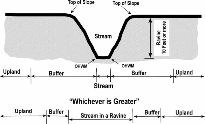
FIGURE 2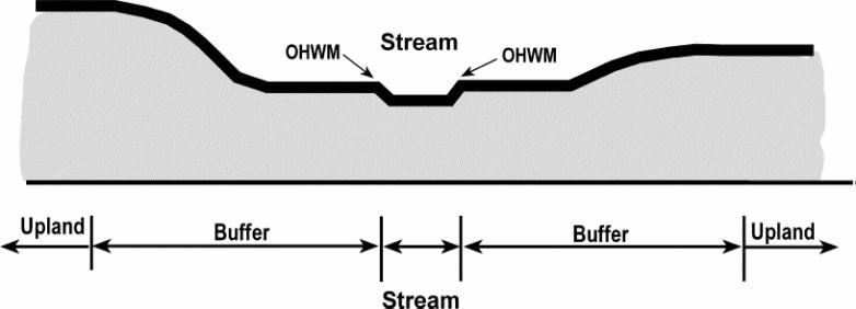
FIGURE 3
(Ord. 6426 §21, 2006; Ord. 6356 §5, 2005).
18.32.440 Streams and Important Riparian Areas - Special Reports
A. Every application for development within a stream, or "important riparian area" or their buffer shall include a drainage and erosion control plan and a grading plan.
B. For applications which propose a reduction of the buffer pursuant to OMC 18.32.435(F) and (G), or for uses and activities which require Hearing Examiner authorization in OMC 18.32.430, a Biological Assessment shall be submitted.
(Ord. 6426 §22, 2006; Ord. 6356 §5, 2005).
18.32.445 Streams and Important Riparian Areas - Biological Assessment
A. Depending upon the species of salmon, the preparation of a Biological Assessment shall follow the provisions of:
1. National Marine Fisheries Service, 1996. Making Endangered Species Act Determinations of Effect for Individual or Grouped Actions at the Watershed Scale. National Marine Fisheries Service, Environmental and Technical Services Division, Habitat Conservation Division, Portland, Oregon, or
2. U.S. Fish and Wildlife Service, 1998. A Framework to Assist in Making Endangered Species Act Determinations of Effect for Individual or Grouped Actions at the Bull Trout Subpopulation Watershed Scale (draft). Prepared by United States Fish and Wildlife Service (adapted from the National Marine Fisheries Service).
B. The Biological Assessment shall be prepared by a person who has sufficient experience and education in fish biology, as determined by the Department.
(Ord. 6426 §23, 2006; Ord. 6356 §5, 2005).
18.32.500 Wetlands and Small Lakes - Purpose and Intent
In order to protect the natural function of wetlands and "small lakes" for floodwater storage, floodwater conveyance, sediment control, pollution control, surface water supply, aquifer recharge, wildlife habitat, and recreation, those lands with wetlands and "small lakes" or which lie within three hundred (300) feet of wetlands and "small lakes" shall be subject to the standards in OMC 18.32.505 through OMC 13.32.595.
(Ord. 6426 §24, 2006; Ord. 6356 §5, 2005).
18.32.505 Wetlands and Small Lakes - Definition
A. "Wetlands" means areas that are inundated or saturated by surface water or ground water at a frequency and duration sufficient to support, and that under normal circumstances do support, a prevalence of vegetation typically adapted for life in saturated soil conditions. Wetlands generally include swamps, marshes, bogs, and similar areas. Wetlands do not include those artificial wetlands intentionally created from nonwetland sites, including, but not limited to, irrigation and drainage ditches, grass-lined swales, canals, detention facilities, wastewater treatment facilities, farm ponds, and landscape amenities, or those wetlands created after July 1, 1990, that were unintentionally created as a result of the construction of a road, street, or highway. Wetlands may include those artificial wetlands intentionally created from nonwetland areas to mitigate the conversion of wetlands.
B. "Small Lakes" means naturally existing bodies of standing water less than twenty acres in size, which exist on a year-round basis in a depression of land or expanded part of a stream and not defined as "Shorelines of the State" by RCW 90.58 (Shoreline Management Act). This term does not apply to constructed ponds.
(Ord. 6426 §25, 2006; Ord. 6356 §5, 2005).
18.32.510 Wetlands and Small Lakes - Rating System
A. The Washington State Wetland Rating System for Western Washington (2004) as amended or revised, shall be used to determine if the wetland is a Category I, II, III or IV wetland. These documents contain the criteria, definitions and methods for determining if the criteria below are met.
1. Category I wetlands are those that 1) represent a rare wetland type; 2) are highly sensitive to disturbance; 3) are relatively undisturbed and contain ecological attributes that are impossible to replace within a human lifetime; 4) provide a very high level of functions; or are designated as high value wetlands of local significance.
2. Category II wetlands are those that 1) are sensitive to disturbance, 2) are difficult to replicate, 3) wetlands with a moderately high level of functions or are designated as wetlands of local significance. These wetlands are difficult, though not impossible, to replace, and provide high levels of some functions. These wetlands occur more commonly than Category I wetlands, but still need a high level of protection.
3. Category III wetlands are wetlands with a moderate level of functions. These wetlands generally have been altered in some ways, or are smaller, less diverse and/or more isolated in the landscape than Category II wetlands. For the purpose of this chapter, all "small lakes" shall be considered to be Category III wetlands.
4. Category IV wetlands have the lowest levels of functions, and often have been heavily altered. These are wetlands where it may be possible to replace, and in some cases be able to improve. These wetlands do provide some important functions, and should to some degree be protected.
B. Wetland rating categories shall be applied as the wetland exists on the date of application. However, wetland ratings shall not recognize alterations resulting from illegal activities.
(Ord. 6426 §26, 2006; Ord. 6356 §5, 2005).
18.32.515 Wetlands and Small Lakes - Small Wetlands
A. Wetlands and "small lakes" less than one thousand (1,000) square feet shall be exempt from the requirements of OMC 18.32.135.A; wetland buffers in OMC 18.32.535, compensation projects in OMC 18.32.545 and replacement ratios in OMC 18.32.550 provided that the wetland or pond:
1. Is not associated with a riparian corridor,
2. Is not part of a wetland mosaic, and
3. Does not contain habitat identified as essential for local populations of priority species identified by Washington Department of Fish and Wildlife.
B. Wetlands and "small lakes" between one thousand (1,000) and four thousand (4,000) square feet shall be exempt from the requirements of OMC 18.32.135.A, provided that the wetland or small lake:
1. Is rated as a Category III or IV wetland,
2. Is not associated with a riparian corridor,
3. Is not part of a wetland mosaic,
4. Does not score 20 points or greater for habitat in the Washington State Wetland Rating System for Western Washington (2004),
5. Does not contain habitat identified as essential for local populations of priority species identified by Washington Department of Fish and Wildlife, and
6. A wetland mitigation report is provided as required by OMC 18.32.590.
(Ord. 6426 §27, 2006; Ord. 6356 §5, 2005).
18.32.518 Wetlands and Small Lakes - Prohibited Alterations
The following alterations or commencement of the following activities are prohibited within a wetland and its associated buffer, except as specified in OMC 18.37.070, 18.32.520 - Exempt Uses and Activities, OMC 18.32.525 - Administratively Authorized Uses and Activities, or OMC 18.32.530 - Hearing Examiner Authorized Uses and Activities:
Any human action which changes the existing condition including but not limited to:
A. Grading;
B. Dredging;
C. Channelizing;
D. Cutting;
E. Clearing;
F. Filling;
G. Paving;
H. Building of structures;
I. Demolition of structures;
J. Relocating or removing vegetation;
K. Introduction of invasive plant species;
L. Application of herbicides, pesticides, or any hazardous or toxic substance;
M. Discharging pollutants;
N. Grazing domestic animals;
O. Modifying for surface water management purposes; or
P. Any other human activity that changes the existing vegetation, hydrology, wildlife, or wildlife habitat.
(Ord. 6426 §29, 2006; Ord. 6356 §5, 2005).
18.32.520 Wetlands and Small Lakes - Exempt Uses and Activities
The following activities shall be exempt from the review requirements of this Chapter:
A. Activities within an Improved Right-of-Way, except those activities that alter a stream or wetland, such as a bridge or culvert, or result in the transport of sediment or increased stormwater.
B. Forest Practices Class I, II, and III, as defined in and conducted pursuant to the provisions of RCW 76.09.050, as amended.
C. Construction and/or maintenance of a trail in the wetland buffer, four (4) feet or less in width, not paved, and involving less than fifty (50) cubic yards of cut or fill.
D. Non-commercial Signs Associated with wetlands, including interpretive signs, Critical Area boundary signs, and survey markers.
E. Normal Maintenance or Repair.
F. Passive Recreation Activities.
(Ord. 6426 §30, 2006; Ord. 6356 §5, 2005).
18.32.525 Wetlands and Small Lakes - Administratively Authorized Uses and Activities
The following uses and activities may be authorized within a wetland or its buffer after an evaluation by the Department.
A. Beach or Shoreline Access.
B. Dock/Float in Category III and IV Wetlands only.
C. Compensation Mitigation Site in Category III and IV Wetlands only, and the buffer only of Category II Wetlands.
D. Fencing.
E. Forest Practices. Forest practices may be allowed pursuant to the provisions of OMC 16.60 and RCW 76.09.050, as amended in Category III and IV Wetlands.
F. Minor Enhancement. Minor enhancement may be allowed of wetlands or wetland buffers not associated with any other development proposal in order to enhance wetland functions, as determined by the Department and any state agency or tribal entity with jurisdiction. Such enhancement shall be performed under a plan for the design, implementation, maintenance and monitoring of the project prepared by a civil engineer and a fisheries biologist with experience preparing riparian enhancement reports, under the direct supervision of a wetland scientist.
G. Minor Restoration. Minor Restoration may be allowed but shall be limited to Category II, III and IV Wetlands and the buffer of Category I Wetlands.
H. Noxious Weed Control
I. Nondevelopment Educational Activities and Scientific Research
J. Road/Street-Expansion of Existing Corridor and New Facilities in Category III and IV Wetlands only as follows:
1. Crossings of wetlands or other critical areas shall be avoided to the extent to the extent possible
2. Crossing of wetlands shall follow all applicable local, state and federal laws and the following criteria:
3. Bridge-type structures are required for new crossings of wetlands;
4. Crossings using culverts shall use super span or oversize culverts.
5. Crossings shall be constructed and installed during periods of time when there will be the least impact on the adjacent fish and wildlife habitat;
6. Bridge piers or abutments shall not be placed in either the floodway or between the ordinary high water marks unless no other feasible alternative placement exists;
7. Crossings shall not diminish flood carrying capacity;
8. Crossings shall provide for maintenance of culverts, bridges and utilities; and
9. Crossings shall serve multiple properties whenever possible.
K. Stormwater Facilities may be allowed only in the outer half of Category III and IV wetland buffers only, and only when:
1. The facility does not exceed twenty-five (25) percent of the buffer on site; and
2. The location of such facilities will not degrade or have a significant, adverse impact on the functions or values of the wetland or buffer.
L. Trail construction or maintenance of a trail greater than four (4) feet wide, with a paved surface, and/or involving more than fifty (50) cubic yards of cut or fill located in a Category II, III or IV wetland, but only when the department has determined that there are no practicable or reasonable alternatives:
1. Public and private trails and trail-related facilities, (such as picnic tables, benches, interpretive centers and signs and, viewing platforms and campsites) shall be allowed, but use of impervious surfaces shall be minimized.
2. Trail planning, construction and maintenance shall adhere to the following additional criteria:
a. Trails and related facilities shall, to the extent feasible, be placed on previously disturbed areas such as: existing or abandoned levees, or road, railroad, or utility corridors; and
b. Trails and trail related facilities shall be planned to minimize removal of trees, shrubs, snags and important wildlife habitat.
M. Utility lines may be allowed within Category II, III and IV wetlands and their buffers when it is demonstrated that:
1. There are no practicable upland alternatives for the utility corridor;
2. The corridor alignment follows a path of least impact to the functions of the stream and buffer critical areas including maintaining and protecting the hydrologic and hydraulic functions of wetlands and streams;
3. The utility provider avoids cutting trees in the corridor greater than six (6) inches in diameter at breast height when possible; and
4. Any access to the corridor for maintenance is provided as much as possible at specific points rather than by parallel roads.
N. Wildlife Blind.
(Ord. 6426 §31, 2006; Ord. 6356 §5, 2005).
18.32.530 Wetlands and Small Lakes - Hearing Examiner Authorized Uses and Activities
The following uses and activities may be authorized within a wetland or its buffer after a review by the Hearing Examiner.
A. Communication Towers in the buffers of Category III and IV Wetlands only.
B. Compensation Mitigation Site in Category II Wetlands only.
C. Dock/Float in Category II Wetlands only.
D. Road/Street only:
1. In Category II wetlands subject to the performance standards for Road/Street - Expansion of Existing Corridor and New Facilities in OMC 18.32.525(J).
2. In Category I wetlands subject to the performance standards for Road/Street - Expansion of Existing Corridor and New Facilities in OMC 18.32.525(J), and being processed as a "public project of significant importance."
E. Stormwater Facilities in Category III or IV wetlands only, and in the outer half only of a Category II standard wetland buffer, provided that if the placement of such a facility in a wetland results in elimination of an area’s wetland status, then mitigation will be required to compensate for the loss of that wetland as provided in OMC 18.32.550.
F. Trail construction or maintenance of a trail greater than four (4) feet wide, with a paved surface, and/or involving more than fifty (50) cubic yards of cut or fill located in a Category I wetland, but only when the Hearing Examiner has determined that there are no practicable or reasonable alternatives. Trails shall be subject to the performance standards for Trails in OMC 18.32.525(L).
G. Utility Facility only in Category I, II, III and IV wetlands.
(Ord. 6426 §32, 2006; Ord. 6356 §5, 2005).
18.32.535 Wetlands and Small Lakes - Wetland Buffers
Wetlands buffer areas shall be maintained between all regulated activities and wetlands to retain the wetlands’ natural functions and values. The required width of the wetland buffer shall be determined as provided in the tables below. Wetland buffers are based upon the rating of the wetland pursuant to OMC 18.32.585.
|
Wetland Characteristics |
Wetland Buffer Width |
|
Natural Heritage Wetlands |
Not less than 250 feet |
|
Bogs |
Not less than 250 feet |
|
Estuarine - Category I |
250 feet |
|
Estuarine - Category II |
150 feet |
|
Habitat score: 31 pts and more |
300 feet |
|
Habitat score: 30 pts |
280 feet |
|
Habitat score: 29 pts |
260 feet |
|
Habitat score: 28 pts |
240 feet |
|
Habitat score: 27 pts |
220 feet |
|
Habitat score: 26 pts |
200 feet |
|
Habitat score: 25 pts |
180 feet |
|
Habitat score: 24 pts |
160 feet |
|
Habitat score: 23 pts |
140 feet |
|
Habitat score: 22 pts |
120 feet |
|
Habitat score: 21 pts |
100 feet |
|
Habitat score: 20 pts |
100 feet |
|
Habitat score: 19 pts |
100 feet |
|
Water Quality Improvement Score: 24 - 32 pts, and Habitat score: 19 pts or less |
100 feet |
|
Category I or II Wetland - Not meeting any of the above criteria |
100 feet |
|
Category III Wetland - Not meeting any of the above criteria |
80 feet |
|
Category IV Wetland - Score for all three wetland functions is less than 30 pts |
50 feet |
C. All wetland buffers shall be measured from the wetland boundary.
D. The wetland buffer widths contained in OMC 18.32.535(B) presume the existence of a relatively intact native vegetation community in the buffer zone adequate to protect the wetland functions and values at the time of the proposed activity. If the vegetation and other buffer elements are inadequate, then the buffer shall be planted to a density of four hundred (400) tree units per acre pursuant to OMC 16.60 including an understory of native plants commonly found in riparian areas of Thurston County.
E. The buffer for a wetland created, restored, or enhanced as compensation for approved wetland alterations shall be the same as the buffer required for the category of the created, restored, or enhanced wetland.
F. The Department may allow modification of the required wetland buffer width by averaging buffer widths when all of the following conditions are met:
1. The wetland has significant differences in characteristics that affect its habitat functions, such as a wetland with a forested component adjacent to a degraded emergent component or a "dual-rated" wetland with a Category I area adjacent to a lower rated area,
2. The buffer is increased adjacent to the higher-functioning area of habitat or more sensitive portion of the wetland and decreased adjacent to the lower functioning or less sensitive portion,
3. The total area of the buffer after averaging is equal to the area required without averaging, and
4. The buffer at its narrowest point is never less than seventy five percent (75%) of the required width.
G. The Department may reduce the required wetland buffer widths by twenty five percent (25%) under the following conditions:
1. For wetlands that score twenty (20) points or more for the habitat functions, if both of the following criteria are met:
a. A relatively undisturbed, vegetated corridor at least one hundred (100) feet wide is protected between the wetland and any other priority habitats as defined by the Washington State Department of Fish and Wildlife. The corridor must be protected for the entire distance between the wetland and the priority habitat by legal protection such as a conservation easement.
b. Measures to minimize the impacts of different land uses on wetlands, such as those described on Table 8c-11, Appendix 8-C, of Wetlands in Washington State - Volume 2: Guidance for Protecting and Managing Wetlands (2005) Ecology publication #05-06-008, as amended or revised, are applied. Examples of these measures include directing lighting away from wetland, locating noise generating activities away from the wetland, and densely planting the buffer to act as barrier to pets and human disturbance.
2. For wetlands that score nineteen (19) points or less for habitat function, apply the provisions of OMC 18.32.535(G)(1)(b).
H. The Hearing Examiner may allow:
1. Reductions to the required wetland buffer width greater than those described in OMC 18.32.535 G on a case-by-case basis when it can be demonstrated that:
a. The provisions of OMC 18.32.535(G) have been evaluated by a Wetland Mitigation Report described in OMC 18.32.590, and
b. The proposed wetland buffer width will protect the wetlands’ functions and values based upon the Wetland Mitigation Report and the best available science.
2. Buffer averaging up to fifty percent (50%) of the required width, except for a Category IV wetland, when it can be demonstrated that:
a. It will not reduce wetland functions or values according to a Wetland Mitigation Report described in OMC 18.32.590;
b. Measures to minimize the impacts of different land uses on wetlands, such as those described on Table 8c-11, Appendix 8-C, of Wetlands in Washington State - Volume 2: Guidance for Protecting and Managing Wetlands (2005) Ecology publication #05-06-008, as amended or revised, are applied;
c. The total area contained in the buffer area after averaging is no less than that which would be contained within the standard buffer; and
d. The wetland buffer has been placed in a critical areas tract or a conservation easement.
(Ord. 6426 §33, 2006; Ord. 6356 §5, 2005).
18.32.540 Wetlands and Small Lakes - Compensating for Loss or Affected Functions
A. Property development that may result in the loss of wetland or "small lake" or adversely affect wetland values and/or functions shall provide compensatory mitigation in accordance with the order of priority set forth in OMC 18.32.135.
B. Compensatory mitigation shall provide functional equivalency or improvement of the wetland functions lost, except when either:
1. The lost wetland provides minimal functions as determined by a site specific function assessment, and the proposed compensatory mitigation action(s) will provide equal or greater functions or will provide functions shown to be limiting within a watershed through a formal Washington State watershed assessment plan or protocol; or
2. Out-of-kind replacement of wetland type or functions will best meet watershed goals, such as replacement of historically diminished wetland types.
(Ord. 6426 §34, 2006; Ord. 6356 §5, 2005).
18.32.545 Wetlands and Small Lakes - Compensation Projects
A. Any wetland compensation project prepared pursuant to this Chapter and approved by the Department shall become part of the approved development project.
B. Critical area tracts or a conservation easement for any mitigation area created, restored or enhanced as a part of a wetland mitigation proposal will be required if necessary to provide a reasonable assurance that the mitigation or adverse impacts will not be lost after the completion of the project, or to provide a reasonable period of time for establishment of a functioning system. The regulatory agency may accept a comparable use restriction such as, but not limited to, state or federal ownership.
C. The person proposing a wetland compensation project shall demonstrate to the Department that sufficient expertise, supervisory capability and financial resources exist to carry out the proposed compensation project. The needed expertise, supervisory capability and financial resources will be commensurate with the proposed compensation. At minimum, the project applicant must provide a description of the personnel who will be involved in carrying out and supervising the project including academic degrees, areas of experience and work experience to date.
D. Compensation areas shall be determined according to function, acreage, type, location, time factors, ability to be self sustaining and projected success. Wetland functions and values shall be determined by use of the Washington State Methods for Assessing Wetland Functions (1999), Ecology Publication #99-115 and 99-116, as amended. Multiple compensation projects may be proposed for one project in order to best achieve the goal of no net loss.
E. A development project by a public entity, or a private development project with a wetland less than four thousand (4,000) square feet, may pay a fee to the Department to have the City construct a compensation project. Such a proposal shall be on a case by case basis, must have funds committed towards a project on property owned by the city, a public entity, or a nonprofit agency acceptable to the City and meets all other provisions of this Chapter.
F. When loss or disturbance of wetland results from a violation of this Chapter or of any permit, order or approved mitigation plan issued pursuant thereto, penalties provided in OMC 18.73 may be imposed.
(Ord. 6426 §35, 2006; Ord. 6356 §5, 2005).
18.32.550 Wetlands and Small Lakes - Replacement Ratios
A. The wetland replacement ratios shall be those described on Table 8c-11, Appendix 8-C, of Wetlands in Washington State - Volume2: Guidance for Protecting and Managing Wetlands (2005) Ecology publication #05-06-008, as amended or revised.
B. When the acreage required for compensatory mitigation is divided by the acreage of wetland adversely affected, the result is a number known variously as a replacement, compensation, or mitigation ratio. Compensatory mitigation ratios are used to help ensure that compensatory mitigation actions are adequate to offset unavoidable wetland impacts by requiring a greater amount of mitigation area than the area of impact.
(Ord. 6426 §36, 2006; Ord. 6356 §5, 2005).
18.32.555 Wetlands and Small Lakes - Increase and Reduction to Replacement Ratios
A. The Department may increase the wetland replacement ratios contained in OMC 18.32.550 under any of the following circumstances:
1. Uncertainty as to the probable success of the proposed restoration or creation;
2. Significant period of time between destruction and replication of wetland functions;
3. Projected losses in functional value; or
4. The wetland impact was unauthorized.
B. The Department may decrease the wetland replacement ratios for Category II, III, and IV wetlands contained in OMC 18.32.550 to not less than a 1 to 1 acreage replacement ratio when a qualified wetlands specialist can document that:
1. The proposed mitigation actions have a very high likelihood of success, and either
2. The proposed mitigation actions will provide functions and values that are significantly greater than the wetland being impacted, or
3. The proposed mitigation actions which are to be conducted in advance of the wetland impact have been shown to be successful.
(Ord. 6426 §37, 2006; Ord. 6356 §5, 2005).
18.32.560 Wetlands and Small Lakes - Type and Location of Compensation Mitigation
A. Compensatory mitigation actions shall be conducted on the site of the alteration except when all of the following apply:
1. There are no reasonable on-site or in drainage of sub-basin opportunities (e.g., on-site options would require elimination of high-functioning upland habitat), or on-site and in sub-drainage basin opportunities do not have a high likelihood of success based on a determination of the capacity of the site to compensate for the impacts. Considerations should include: anticipated replacement ratios for wetland mitigation, buffer conditions and proposed widths, available water to maintain anticipated hydro geomorphic classes of wetlands when restored, proposed flood storage capacity, and potential to mitigate riparian fish and wildlife impacts (such as connectivity); and
2. Off-site mitigation has a greater likelihood of providing equal or improved wetland functions than the impacted wetland.
B. Off-site compensatory mitigation shall be provided in the same drainage sub-basin unless:
1. Established watershed goals for water quality, flood storage or conveyance, habitat, or other wetland functions have been established by the department and strongly justify location of mitigation at another site in a different drainage sub-basin; or
2. Credits from a state-certified wetland mitigation bank are used as compensation and the use of credits is consistent with the terms of the bank’s certification.
C. The design for the compensatory mitigation project shall be appropriate for its location (i.e., position in the landscape). Therefore, compensatory mitigation should not result in the creation, restoration, or enhancement of an atypical wetland. An atypical wetland is a compensation wetland (e.g., created or enhanced) that does not match the type of existing wetland that would be found in the geomorphic setting of the site (i.e., the water source(s) and hydroperiod proposed for the mitigation site are not typical for the geomorphic setting). It should not provide exaggerated morphology or require a berm or other engineered structures to hold back water.
(Ord. 6426 §38, 2006; Ord. 6356 §5, 2005).
18.32.565 Wetlands and Small Lakes - Mitigation Timing
A. Where feasible, compensatory projects shall be completed prior to activities that will permanently disturb wetlands, and immediately after activities that will temporarily disturb wetlands.
B. In all cases compensatory projects shall be completed within one year after use or occupancy of the activity or development which was conditioned upon such compensation.
C. Construction of compensation projects shall be timed to reduce impacts to existing flora, fauna and fisheries.
D. The Department may authorize a one-time delay not to exceed twelve (12) months in the construction or installation of the compensatory mitigation. A written request shall be prepared by a qualified wetland professional and include the rationale for the delay. In granting a delay the Department must determine that it will not be injurious to the health, safety, and general welfare of the public.
(Ord. 6426 §39, 2006; Ord. 6356 §5, 2005).
18.32.570 Wetlands and Small Lakes - Wetland Mitigation Banks
A. Credits from a wetland mitigation bank may be approved for use as compensation for unavoidable impacts to wetlands when:
1. The bank is certified under Chapter 173-700 WAC;
2. The Department determines that the wetland mitigation bank provides appropriate compensation for the authorized impacts; and
3. The proposed use of credits is consistent with the terms and conditions of the bank’s certification.
B. Replacement ratios for projects using bank credits shall be consistent with replacement ratios specified in the bank’s certification.
C. Credits from a certified wetland mitigation bank may be used to compensate for impacts located within the service area specified in the bank’s certification. In some cases, the service area of the bank may include portions of more than one adjacent drainage basin for specific wetland functions.
(Ord. 6426 §40, 2006; Ord. 6356 §5, 2005).
18.32.575 Wetlands and Small Lakes - Special Reports
Every application for development that proposed to be located within or adjacent to a regulated wetland or its buffer shall include the following special reports:
A. Wetland boundary delineation,
B. Wetland rating report (if the wetland is unrated),
C. Wetland mitigation report, and
D. Wetland compensatory mitigation plan (if the application includes wetland replacement).
(Ord. 6426 §41, 2006; Ord. 6356 §5, 2005).
18.32.580 Wetlands and Small Lakes - Wetland Boundary Delineation
A. A wetland boundary delineation report shall establish the exact location of a wetland’s boundary based on a field investigation by a qualified professional applying the Washington State Wetlands Identification and Delineation Manual, (1997) Ecology Publication #96-94, as amended or revised.
B. The boundary delineation shall be prepared by a wetland biologist with experience preparing wetland reports, such as an individual certified by the Society of Wetland Scientists.
C. The wetland boundary, wetland buffer, and any critical area tract shall be identified on all grading, landscaping, site, utility or other development plans submitted on the project.
(Ord. 6426 §42, 2006; Ord. 6356 §5, 2005).
18.32.585 Wetlands and Small Lakes - Wetland Rating Report
A. A wetland rating report shall categorize the wetland (e.g., I, II, III, or IV) based on the Washington State Wetland Rating System for Western Washington (2004) as amended or revised.
B. The applicant may elect to pay a fee to the Department in lieu of submitting the wetland rating report. The Department will hire a qualified individual or firm to prepare the wetlands rating report.
C. The Department will determine the wetland category and required buffer width.
(Ord. 6426 §43, 2006; Ord. 6356 §5, 2005).
18.32.587 Wetlands and Ponds - Wetland Rating Report
A. The Washington State Wetland Rating System for Western Washington (2004) as amended or revised, shall be used to determine if the wetland is a Category I, II, III or IV wetland.
B. A wetland rating report shall categorize the wetland (e.g., I, II, III, or IV) based on the Washington State Wetland Rating System for Western Washington (2004 as amended or revised.
C. The applicant may elect to pay a fee (See OMC 4.) to the Olympia Community Planning and Development Department in lieu of submitting the wetland rating report. The Olympia Community Planning and Development Department will hire a consultant from a list of qualified individuals or firms to prepare the wetlands rating report.
D. The Department will determine the wetland category and required buffer width based on the wetlands rating report
(Ord. 6356 §5, 2005).
18.32.590 Wetlands and Small Lakes - Wetland Mitigation Report
A. A Wetland Mitigation Report shall include an evaluation of the functions and values of the wetland.
B. It shall be prepared by a wetland biologist with expertise in preparing wetlands reports.
C. The report may include the wetland boundary delineation and the wetland rating.
D. The report shall include a list of the mitigation measures proposed, based upon OMC 18.32.135.
E. It shall include a to-scale map with conditions as appropriate to the site. Use OMC 18.32.595 (D) as guidance for those features to be included on this map.
(Ord. 6426 §44, 2006).
18.32.595 Wetlands and Small Lakes - Wetland Compensation Mitigation Report
A. The Wetland Compensation Mitigation Report must include a written report and map with the following elements. Full guidance can be found in the Guidance on Wetland Mitigation in Washington State - Part 2: Guidelines for Developing Wetland Mitigation Plans and Proposals, (2004) - Washington State Department of Ecology, U.S. Army Corps of Engineers Seattle District, and U.S. Environmental Protection Agency Region 10; Ecology Publication #04-06-013b, as amended or revised.
B. The report shall be prepared by a wetland biologist with experience preparing wetland reports, such as an individual certified by the Society of Wetland Scientists.
C. The written report must contain:
1. The name and contact information of the applicant; the name, qualifications, and contact information for the primary author(s) of the report; a description of the proposal; a summary of the impacts and proposed compensation concept; identification of all the local, state, and/or federal wetland related permit(s) required for the project; and a vicinity map for the project;
2. Description of the existing wetland and buffer areas proposed to be impacted including: acreages (or square footage) based on professional surveys of the delineations; Cowardin classifications including dominant vegetation community types (for upland and wetland habitats); hydro geomorphic classification of wetland(s) on and adjacent to the site; the results of a functional assessment for the entire wetland and the portions proposed to be impacted; wetland rating based upon OMC 18.32. 585;
3. An assessment of the potential changes in wetland hydroperiod from the proposed project and how the design has been modified to avoid, minimize, or reduce adverse impacts to the wetland hydroperiod;
4. An assessment of existing conditions in the zone of the proposed compensation, including: vegetation community structure and composition, existing hydroperiod, existing soil conditions, existing habitat functions. Estimate future conditions in this location if the compensation actions are NOT undertaken (i.e., how would this site progress through natural succession?);
5. A description of the proposed actions to compensate for the wetland and upland areas affected by the project. Describe future vegetation community types for years one (1), three (3), five (5), ten (10), and twenty five (25) post-installation including the succession of vegetation community types and dominants expected. Describe the successional sequence of expected changes in hydroperiod for the compensation site(s) for the same time periods as vegetation success. Describe the change in habitat characteristics expected over the same twenty five (25) year time period;
6. The field data collected to document existing conditions and on which future condition assumptions are based for hydroperiod (e.g., existing hydroperiod based on piezometer data, staff/crest gage data, hydrologic modeling, visual observations, etc.) and soils (e.g., soil pit data - hand dug or mechanically trenched, and soil boring data. Do not rely upon soil survey data for establishing existing conditions.);
7. A discussion of ongoing management practices that will protect wetlands after the project site has been developed, including proposed monitoring and maintenance programs (for remaining wetlands and compensatory mitigation wetlands);
8. The estimated total cost for the bond for the entire compensatory mitigation project, including the following elements: site preparation, plant materials, construction materials, installation oversight, maintenance twice/year for up to five (5) years, annual monitoring field work and reporting, and contingency actions for a maximum of the total required number of years for monitoring. The estimate shall be in sufficient detail to permit issuance of a bond to guarantee performance of the work; and
9. Proof of establishment of Notice on Title for the wetlands and buffers on the project site, including the compensatory mitigation areas.
D. The map must contain:
1. Surveyed edges of the existing wetland and buffers, proposed areas of wetland and/or buffer impacts, location of proposed wetland and/or buffer compensation actions;
2. Existing topography, ground-proofed, at two-foot contour intervals in the zone of the proposed compensation actions if any grading activity is proposed to create the compensation area(s). Also existing cross-sections of on-site wetland areas that are proposed to be impacted, and cross-section(s) (estimated one-foot intervals) for the proposed areas of wetland or buffer compensation;
3. Surface and subsurface hydrologic conditions including an analysis of existing and proposed hydrologic regimes for enhanced, created, or restored compensatory mitigation areas. Also, illustrations of how data for existing hydrologic conditions were used to determine the estimates of future hydrologic conditions;
4. Proposed conditions expected from the proposed actions on site including future hydro geomorphic types, vegetation community types by dominant species (wetland and upland), and future hydrologic regimes;
5. Required wetland buffers for existing wetlands and proposed compensation areas. Also, identify any zones where buffers are proposed to be reduced or enlarged outside of the standards identified in this Title;
6. A plant schedule for the compensatory area including all species by proposed community type and hydrologic regime, size and type of plant material to be installed, spacing of plants, "typical" clustering patterns, total number of each species by community type, timing of installation; and
7. Performance standards (measurable standards reflective of years post-installation) for upland and wetland communities, monitoring schedule, and maintenance schedule and actions by each year.
(Ord. 6426 §46, 2006).
18.32.600 Landslide Hazard Areas - Purpose and Intent
In order to minimize damage to health and property due to landslide, or other naturally occurring events; control erosion, siltation, and stream health which affect fish and shellfish resources; and safeguard the public from hazards associated with landslides, mud flows and rock fall, landslide hazard areas shall be subject to the standards described in OMC 18.32.605 through OMC 18.32.645.
(Ord. 6356 §5, 2005).
18.32.605 Landslide Hazard Areas - Applicability and Definition
A. "Landslide Hazard Area" means those areas which are potentially subject to risk of mass movement due to a combination of geologic, topographic and hydrologic factors; and where the vertical height is ten (10) feet or more. The following areas are considered to be subject to landslide hazards:
1. Steep slopes of forty (40) percent or greater (refer to Figure 6);
2. Slopes of fifteen (15) percent or greater, with:
a. Impermeable subsurface material (typically silt and clay), frequently interbedded with granular soils (predominantly sand and gravel), and
b. Springs or seeping groundwater during the wet season (November to February) (Refer to Figure 7).
3. Any areas located on a landslide feature which has shown movement during the past ten thousand years or which is underlain by mass wastage debris from that period of time.
B. Not included in the definition of "Landslide Hazard Area" are those man-made steep slopes which were created in conformance with accepted construction standards or which meet the requirement of 18.32.640(C).
(Ord. 6356 §5, 2005).
18.32.610 Landslide Hazard Areas - Prohibited Alterations
The following alterations or commencement of the following activities shall be prohibited within a landslide hazard area and its associated buffer; except as specified in OMC 18.37.070, 18.32.415 - Exempt Uses and Activities, OMC 18.32.420 - Administratively Authorized Uses and Activities, or OMC 18.32.425 - Hearing Examiner Authorized Uses and Activities:
Any human action which changes the existing condition including but are not limited to:
A. Grading;
B. Dredging;
C. Channelizing;
D. Cutting;
E. Clearing;
F. Filling;
G. Paving;
H. Building of structures;
I. Demolition of structures;
J. Relocating or removing vegetation;
K. Introduction of invasive plant species;
L. Application of herbicides, pesticides, or any hazardous or toxic substance;
M. Discharging pollutants;
N. Grazing domestic animals;
O. Modifying for surface water management purposes; or
P. Any other human activity that changes the existing vegetation, hydrology, wildlife, or wildlife habitat.
(Ord. 6356 §5, 2005).
18.32.615 Landslide Hazard Areas - Exempt Uses and Activities
The following activities shall be exempt from the review requirements of this Chapter:
A. Activities within an Improved Right-of-Way, except those activities that alter a stream or wetland, such as a bridge or culvert, or result in the transport of sediment or increased stormwater.
B. Fencing.
C. Forest Practices Class I, II, and III, as defined in and conducted pursuant to the provisions of RCW 76.09.050, as amended.
D. Construction and/or maintenance of a trail in the stream buffer, four (4) feet or less in width, not paved, and involving less than fifty (50) cubic yards of cut or fill.
E. Non-commercial Signs Associated with Streams, including interpretive signs, Critical Area boundary signs, and survey markers.
F. Normal Maintenance or Repair.
G. Passive Recreation Activities.
H. Wildlife Nesting Structure.
(Ord. 6356 §5, 2005).
18.32.620 Landslide Hazard Areas - Administratively Authorized Uses and Activities
The Department may, after evaluation, authorize the following uses and activities within a landslide hazard area or its buffer:
A. Beach or Shoreline Access.
B. Existing Structure - Remodel and Replacement.
C. Forest Practices, pursuant to the provisions of OMC 16.60 and RCW 76.09.050, as amended.
D. Nondevelopment educational activities and scientific research.
E. Noxious Weed Control.
F. Restoration/Revegetation of Site.
G. Site Investigation.
H. Slope Stabilization. The Department may allow the elimination of a landslide hazard area less than twenty (20) feet in height subject to the provision of the IBC.
I. Stormwater Facilities. The Department may allow stormwater facilities only in the outer half of the buffer at the toe of the slope, and only if the applicant demonstrates:
1. No practicable alternative exists;
2. The facility does not exceed twenty-five (25) percent of the buffer on site; and
3. The stability of the landslide hazard area will not be adversely impacted.
J. Trail construction or maintenance of a trail located immediately adjacent to a stream, greater than four (4) feet wide, with a paved surface, and/or involving more than fifty (50) cubic yards of cut or fill, but only when the Department determines that there are no practicable or reasonable alternatives.
1. Public and private trails and trail-related facilities such as picnic tables, benches, interpretive centers and signs, viewing platforms and campsites shall be allowed, but use of impervious surfaces shall be minimized.
2. Trail planning, construction, and maintenance shall adhere to the following additional criteria:
a. Trails and related facilities shall, to the extent feasible, be placed on previously disturbed areas such as: existing or abandoned levees, or road, railroad, or utility corridors; and
b. Trails and trail related facilities shall be planned to minimize removal of trees, shrubs, snags and important wildlife habitat.
K. Utility Line. Utility lines may be allowed within landslide hazard areas when it can be determined that:
1. There are no practicable alternatives for the utility corridor,
2. The corridor alignment follows a path of least impact to the landslide hazard areas critical areas including maintaining and protecting and retaining the slope stability of streams in ravines and landslide hazard areas;
3. The corridor avoids cutting trees greater than six (6) inches in diameter at breast height when possible; and
4. Any access to the corridor for maintenance is provided as much as possible at specific points rather than by parallel roads.
(Ord. 6426 §48, 2006; Ord. 6356 §5, 2005).
18.32.625 Landslide Hazard Areas - Hearing Examiner Authorized Uses and Activities
The Hearing Examiner may, after review, authorize the following uses and activities within a landslide hazard area or its buffer:
A. Road/Street - Expansion of Existing Corridor and New Facilities.
1. Crossings of landslide hazard areas or other critical areas shall be avoided to the extent possible.
2. Crossings shall serve multiple properties/purposes, whenever possible.
B. Utility Facility.
Refer to the performance standards for Utility Line in OMC 18.32.625(K).
C. Elimination of a Landslide Hazard Area.
When the landslide hazard area has a vertical dimension greater than twenty (20) feet in height and the landslide hazard could be eliminated through site grading.
D. Other uses and activities.
Other uses and activities may be allowed within a landslide hazard area on a case-by-case basis when it can be demonstrated that:
1. A Geotechnical Report described in OMC 18.32.640 has been provided, and
2. The applicant has demonstrated to the Examiner’s satisfaction that legally enforceable commitments, such as bonds, letters of credit, and/or covenants, guarantee the use of development practices that will render the development as safe as if it were not located in a landslide hazard area.
(Ord. 6426 §49, 2006; Ord. 6356 §5, 2005).
18.32.630 Landslide Hazard Areas - Buffers
A. In order to minimize damage to personal health and property due to landslides, a buffer of undisturbed vegetation as provided in this Section shall be maintained between all regulated activities and landslide hazard areas. Development must maximize the retention of existing vegetation and retains all vegetation outside of the developed building area. Vegetation, in the form of ground cover, shrubs or trees, assists in stabilizing the ground surface. Damage to existing vegetation through removal or disturbance can have significant impacts on slope stability. Any removal of vegetation, therefore, must be minimized in steep slope areas. Where removal of vegetation cannot be avoided in order to accommodate a permitted development or to stabilize a slope, an acceptable plan to fully revegetate and restabilize affected areas must be provided.
B. The required buffer width is the greater amount of the following distances measured from the edges of the landslide hazard area (except for Subsection B.4 below):
1. From all sides of the landslide hazard area limits: the distance recommended by the engineering geologist or geotechnical engineer;
2. At the top of the landslide hazard area: a distance of one-third (1/3) the height of the slope,
3. At the bottom of the landslide hazard area a distance of one-half (1/2) the height of the slope;
4. Fifty (50) feet in all directions from a seep; or
5. The minimum distance recommended by the engineering geologist or geotechnical engineer (Refer to Figures 6 and 7).
C. All landslide hazard area buffers shall be measured from the landslide hazard area as located in the field.
D. The landslide hazard area, its buffer, and any critical area tract shall be identified on all grading, landscaping, site, utility or other development plans submitted on the project.
E. The Department may reduce the required landslide hazard areas buffer widths except buffers recommended pursuant to OMC 18.32.630 B 5, up to fifty (50) percent on a case-by-case basis when supported by a Geotechnical Report including the following:
1. Buffer width reduction is supported by a Geotechnical Report described in OMC 18.32.640 that evaluates the criteria in OMC 18.32.630(E);
2. The existing buffer area is well-vegetated;
3. The protection of the landslide hazard area buffer using a fence and sign have been evaluated, as described in OMC 18.32.145;
4. Topographic conditions of the site and the buffer have been evaluated;
5. The intensity and type of the land uses adjacent to the buffer have been evaluated with respect to minimizing potential adverse impacts upon the landslide hazard area; [e.g. publicly owned parks, designated open space areas in plats and binding site plans, or lands with a recorded conservation easement];
6. The site has been evaluated with respect to its site design and building layout to minimize potential risks with landslide hazard areas; and
7. A smaller buffer will be adequate to protect property from the landslide hazard based on the best available science.
F. The Hearing Examiner may allow reductions greater than those described in OMC 18.32.630(E) to the required landslide hazard area buffer width on a case-by-case basis when it can be demonstrated that:
1. The provisions of OMC 18.32.630(E) have been evaluated by a Geotechnical Report described in OMC 18.32.640, and
2. Based upon the Geotechnical Report and the best available science it is demonstrated that the proposed landslide hazard area buffer width will be adequate to protect personal health and property from a landslide from this site.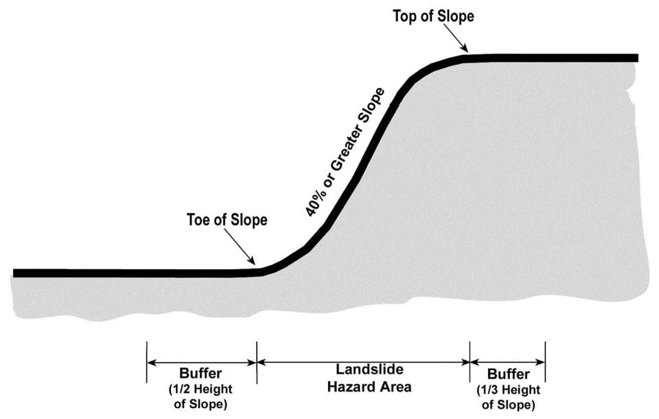
FIGURE 6
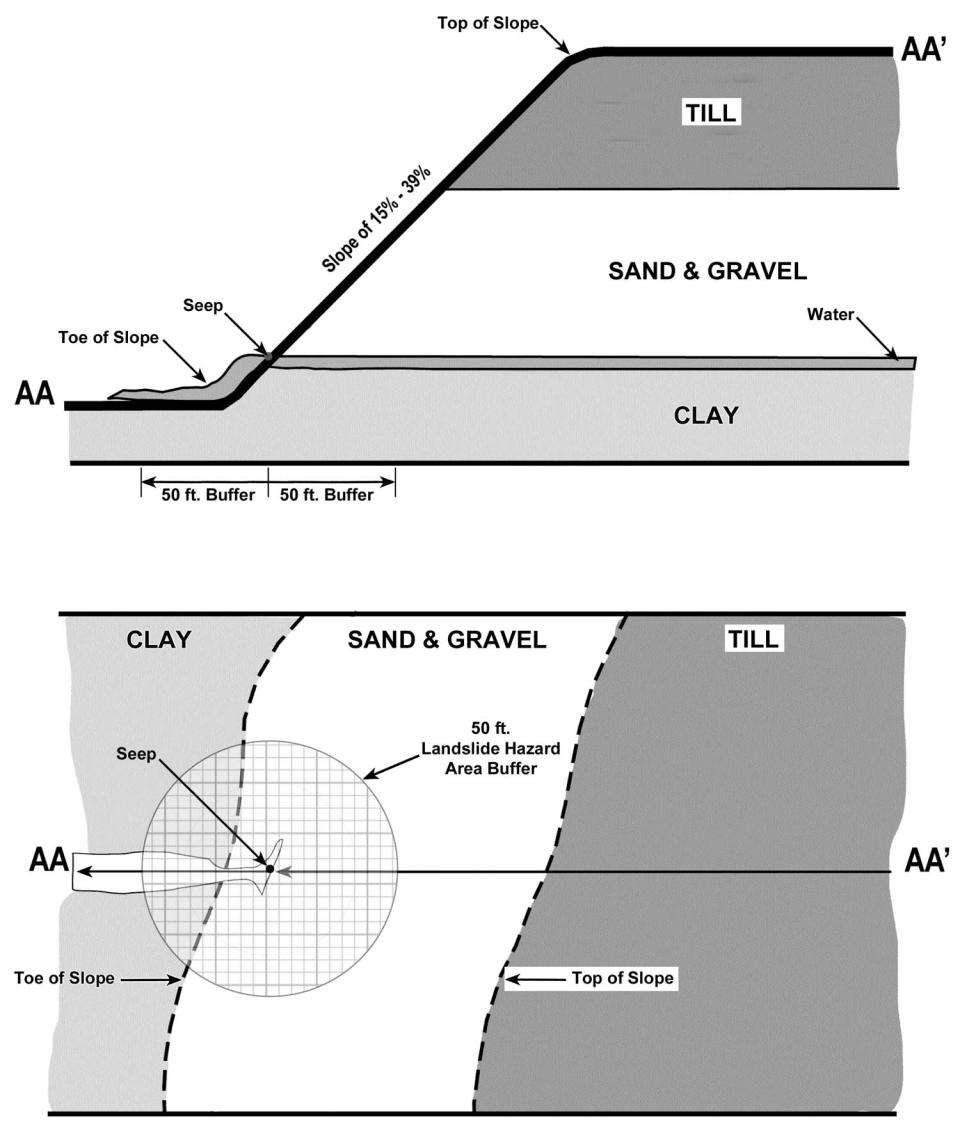
FIGURE 7
(Ord. 6426 §50, 2006; 6356 §5, 2005).
18.32.635 Landslide Hazard Areas - Special Reports
A. Every application for development within a landslide hazard area or its buffer shall provide the following special reports:
1. Drainage and erosion control plan;
2. Grading plan;
3. Geotechnical Report, and
4. Landscape Plan.
B. The Department may waive the submittal of any or all of these special reports when:
1. The proposal increases the impervious surfaces within the subject parcel or parcels by less than ten (10) percent,
2. The removal of vegetation is minimal and is not likely to cause erosion or slope instability,
3. Less than fifty (50) cubic yards of material is excavated upslope from the steep slope,
4. The surface water flow is directed away from the face of the steep slope, or
5. The proposed project or activity will not substantially affect the natural integrity of the steep slope.
(Ord. 6356 §5, 2005).
18.32.640 Landslide Hazard Areas - Geotechnical Report
A. The Geotechnical Report shall be prepared by either an engineering geologist or a geotechnical engineer as defined by RCW 18.220, as amended.
B. The Geotechnical Report shall indicate if:
1. A potential landslide hazard is either present or highly likely; or
2. A potential landslide hazard is present or that it is highly unlikely; or
3. Available information to evaluate a potential landslide hazard is inadequate.
C. Any area in which the Geotechnical Report investigation indicates a potential landslide hazard shall not be subject to development unless the report demonstrates one of the following:
1. The site specific subsurface conditions indicate that the proposed development is not located in a landslide hazard area or its buffer; or
2. The proposed development has been designed so that the risk on the site and to adjacent property have been eliminated or mitigated to such a degree that the site is determined to be safe;
3. Development practices are proposed that would render the development as safe as if it were not located in a landslide hazard area, or
4. The proposed development activity is so minor as not to pose a threat to the public health, safety, and welfare.
D. The Geotechnical Report shall be submitted for review by the Department and shall include:
1. A detailed review of the field investigations, published data and references, data and conclusions from past geological assessments, or geotechnical investigations of the site, site-specific measurements, tests, investigations, or studies,
2. A determination of potential landslide hazard area conditions on the site, and its immediate vicinity, which may affect development on the site,
3. Consideration of the run-out hazard to the proposed development posed by debris from a landslide starting upslope (whether part of the subject property or on a neighboring property) and/or the impacts of landslide run-out on down slope properties, and
4. Results, conclusions and recommendations including supporting analysis and calculations and a list of mitigation measures necessary in order to safely construct or develop within the landslide hazard area.
(Ord. 6356 §5, 2005).
18.32.645 Landslide Hazard Areas - Covenant
A. The Department may require a covenant between the owner(s) of the property and the City when development is to occur within a landslide hazard area. The covenant shall be signed by the owner(s) of the site and notarized prior to issuance of any permit by the City. The covenant shall not be required where the permit or approval is for work done by the City. The covenant shall include:
1. A legal description of the property;
2. A description of the property condition making this subsection applicable;
3. A statement that the owner(s) of the property understands and accepts the responsibility for the risks associated with development on the property given the described condition, and agrees to inform future purchasers and other successors and assignees that the property is located within a landslide hazard area, of the risks associated with development thereon, of any conditions or prohibitions on development imposed by the City, and of any features in this design which will require maintenance or modification to address anticipated soils changes;
4. The application date, type, and number of the permit or approval for which the covenant is required; and
5. A statement waiving the right of the owner(s), the owner’s heirs, successors and assigns to assert any claim against the City for any loss or damage to people or property either on- or off-site resulting from soil movement by reason of or arising out of issuance of the permit or approval by the City for the development on the property, except only for such losses that may directly result from the sole negligence of the City.
B. The covenant shall be filed by the Department with the Thurston County Auditor, at the expense of the owner, so as to become part of the Thurston County real property records.
(Ord. 6356 §5, 2005).