


Chapter 20.162
CRITICAL AREAS REGULATIONS
Sections:
Article I. Critical Areas
20.162.016 Relationship to other regulations.
20.162.018 Inventory provisions.
20.162.020 Administration – Generally.
20.162.022 Application requirements – Generally.
20.162.024 Application requirements – Mitigation sequencing.
20.162.026 Application requirements – Review criteria.
20.162.038 Nonconforming – Existing structures.
20.162.040 Enforcement – Violation – Penalty.
Article II. Definitions
20.162.044 Definitions – Generally.
Article III. Wetlands
20.162.048 Wetland categories.
20.162.052 Development standards.
20.162.054 Regulated uses and activities.
20.162.056 Additional development standards for regulated uses.
20.162.058 Application requirements.
20.162.060 Determination of wetland boundaries.
20.162.062 Wetland mitigation requirements.
20.162.064 Incentives for wetlands protection.
Article IV. Fish and Wildlife Habitat Conservation Areas
20.162.070 Fish and wildlife habitat conservation area categories classification.
20.162.072 Development standards.
Article V. Geologically Hazardous Areas
20.162.076 Geologically hazardous area categories.
20.162.078 Development standards.
Article VI. Frequently Flooded Areas
20.162.080 Purpose and requirements.
Article VII. Critical Aquifer Recharge Areas
20.162.084 Critical aquifer recharge area categories.
20.162.086 Development standards.
Article VIII. Special Reports
20.162.092 Special reports – Responsibility for completion.
20.162.094 Qualifications of professionals.
20.162.096 Wetland report/wetland mitigation plan.
Article IX. Habitat Management Plan
20.162.098 Habitat management plan content.
Article X. Geotechnical Report and Geological Report
20.162.100 Geotechnical report contents.
Article XI. Hydrogeological Reports
20.162.102 Hydrogeological report content.
Article XII. Mitigation Requirements
20.162.104 General mitigation requirements.
Article XIII. Attachments
Article I. Critical Areas
20.162.010 Title.
This chapter shall be known and may be cited as the city of Port Orchard’s “critical areas ordinance” or “CAO.” (Ord. 019-17 § 18 (Exh. 1)).
20.162.012 Purpose.
The purpose of this chapter is to implement the goals, policies, guidelines, and requirements of the city’s comprehensive plan and the Washington State Growth Management Act to protect critical areas, the environment, human life, and property from harm and degradation in accordance with the Growth Management Act through the application of best available science, as determined according to WAC 365-195-900 through 365-195-925 and RCW 36.70A.172, and in consultation with state and federal agencies and other qualified professionals. (Ord. 019-17 § 18 (Exh. 1)).
20.162.014 Applicability.
Except as provided for otherwise herein, the provisions of this chapter shall apply to all persons and agencies, public or private, engaging in land uses, building, and/or development activity in the city of Port Orchard that requires city approval. (Ord. 019-17 § 18 (Exh. 1)).
20.162.016 Relationship to other regulations.
(1) Nothing in this chapter in any way limits, or may be construed to limit, the authority of the city under any other applicable law, nor in any way decreases the responsibility of the applicant to comply with all other applicable local, state, and federal laws and regulations.
(2) These critical areas regulations shall apply as an overlay and in addition to land use, development, building, and other regulations adopted by the city.
(3) When any provision of any other chapter of the POMC conflicts with this chapter or when the provisions of this chapter are in conflict, that provision which provides more protection to environmentally critical areas shall apply unless specifically provided otherwise in this chapter or unless such provision conflicts with federal or state laws or regulations.
(4) Compliance with the provisions of this chapter does not constitute compliance with other federal, state, and local regulations and permit requirements that may be required. The applicant is responsible for complying with these requirements, apart from the regulations established in this chapter.
(5) Where critical areas occur within the city’s shoreline jurisdiction as established by the city’s shoreline master program (Chapter 20.164 POMC), they are regulated under the regulations and provisions of the shoreline master program. (Ord. 019-17 § 18 (Exh. 1)).
20.162.018 Inventory provisions.
(1) The approximate location and extent of mapped critical areas within the city are shown on the maps adopted as part of this chapter, and incorporated herein by this reference. These maps shall be used only as a general guide for the assistance of the department and the public; for a specific development or use proposal, the type, extent and boundaries shall be determined in the field by a qualified specialist or staff person according to the requirements of this chapter. In the event of a conflict between a critical area location shown on the city’s maps and that of an on-site determination, the on-site determination shall apply.
(2) Future Inventory Provisions. The city will review map inventory information of all critical areas as it becomes available or on an annual basis. Mapping will include critical areas that are identified through site-specific analysis by local, state and federal agencies, tribal governments, site-specific environmental reports and other sources. (Ord. 019-17 § 18 (Exh. 1)).
20.162.020 Administration – Generally.
(1) The director, or their authorized designee, shall administer and interpret the provisions of this chapter, except as otherwise specifically provided. The director shall determine whether building, development, platting, or alteration of vegetation, trees, or habitat is subject to this chapter. The director may also consult with other city departments and state and federal agencies as necessary to obtain additional technical and environmental review assistance. The director is authorized to adopt such administrative rules and regulations as are necessary and appropriate to implement the provisions of this chapter.
(2) This chapter is to be administered with flexibility and attention to site-specific characteristics. It is not the intent of this chapter to make a parcel of property unusable by denying its owner reasonable economic use of the property nor to prevent the provision of public facilities and services necessary to support existing development.
(3) The approvals granted under this chapter shall be valid for the same time period as the underlying permit (e.g., preliminary plat, building permit, etc.). If the underlying permit does not contain a specified expiration date, then approvals granted under this chapter shall be valid for a period of three years from the date of issue, unless a longer or shorter period is specified by the director.
(4) If an activity is subject to this chapter but is not subject to any established city permit or approval, the proponent shall obtain written authorization from the director prior to commencement to ensure compliance with this chapter. Such authorization shall be processed as a Type I land use decision pursuant to Chapter 20.22 POMC.
(5) Nothing in this chapter in any way limits, or may be construed to limit, the authority of the city under any other applicable law, nor in any way decreases the responsibility of the applicant to comply with all other applicable local, state, and federal laws and regulations. (Ord. 017-23 § 1 (Exh. A); Ord. 019-17 § 18 (Exh. 1)).
20.162.022 Application requirements – Generally.
(1) Where not otherwise required, all applicants are encouraged to meet with the department prior to submitting an application subject to this title. The purpose of this meeting is to discuss the city’s zoning and applicable critical area requirements, to review any conceptual site plans prepared by the applicant and to identify potential impacts and mitigation measures. Such conference shall be for the convenience of the applicant and any recommendations shall not be binding on the applicant or the city.
(2) To expedite the permit review process, the department shall be the lead agency on all work related to critical areas. Development may be prohibited in a proposed development site based on criteria set forth in this chapter; the applicant should first determine whether this is the case before applying for permits from the department.
(3) Application for development proposals, reasonable use exceptions, or variances regulated by this chapter, or for review of special environmental reports, shall be made with the department by the property owner, lessee, contract purchaser, other person entitled to possession of the property, or by an authorized agent.
(4) All site plan applications for development proposals subject to this chapter shall include a site plan drawn to scale identifying locations of critical areas and any associated buffers, location of proposed structures and activities, including clearing and grading and general topographic information as required by the department. If the department determines that additional critical areas are found on the subject property, the applicant shall amend the site plan to identify the location of the critical area.
(5) A fee in an amount established by the city’s fee schedule shall be paid at the time an application for a permit relating to a critical area or a special report review is filed. (Ord. 019-17 § 18 (Exh. 1)).
20.162.024 Application requirements – Mitigation sequencing.
(1) Applicants shall demonstrate that all reasonable efforts have been examined with the intent to avoid and minimize impacts to critical areas. When alteration to a critical area is proposed, such alteration shall be avoided, minimized, or compensated in the following order of preference:
(a) Avoiding the impact altogether by not taking a certain action or parts of an action;
(b) Minimizing impacts by limiting the degree or magnitude of the action and its implementation by using appropriate technology or by taking affirmative steps, such as project redesign, relocation, or timing, to avoid or reduce impacts;
(c) Rectifying the impact by repairing, rehabilitating, or restoring the affected environment to the conditions existing at the time of the initiation of the project;
(d) Reducing or eliminating the impact over time by preservation and maintenance operations during the life of the action;
(e) Compensating for the impact by replacing, enhancing, or providing substitute resources or environments; and
(f) Monitoring the impact and the compensation project and taking appropriate corrective measures when necessary.
(2) Mitigation measures may be required to address potential impacts that are identified through the sequencing listed above. Mitigation shall be consistent with the requirements of Article XII of this chapter. (Ord. 019-17 § 18 (Exh. 1)).
20.162.026 Application requirements – Review criteria.
(1) Applications for any development proposal subject to the critical areas ordinance shall be reviewed by the director for completeness and consistency or inconsistency with this chapter.
(2) The director may withhold, condition, or deny land use, building, and/or development permits or activity approvals to ensure that the proposed action is consistent with this chapter. In evaluating a request for a development proposal regulated by this chapter, it shall be the responsibility of the director to determine the following:
(a) The nature and type of critical area and the adequacy of any special reports required in applicable sections of this chapter;
(b) Whether the development proposal is consistent with this chapter, by granting, denying, or conditioning projects;
(c) Whether proposed alterations to critical areas are appropriate under the standards contained in this chapter, or whether it is necessary for the applicant to seek a variance or other exception; and
(d) If the protection mechanisms and the mitigation and monitoring plans and bonding measures proposed by the applicant are sufficient to protect the public health, safety and welfare consistent with the purpose and regulations contained in this chapter, and if so, condition the permit or approval accordingly.
(3) At every stage of the application process, the burden of demonstrating that any proposed development is consistent with this chapter is upon the applicant. (Ord. 019-17 § 18 (Exh. 1)).
20.162.028 Bonds.
(1) All bonds and acceptable securities guaranteeing compliance with this chapter shall be set in the amount of 150 percent of the average expected value of the project. The value of the bond shall be based on the engineer’s estimate of the subject work. If the applicant and director do not agree to the engineer’s estimate, then the bond shall be based on the average of three contract bids that establish all costs of compensation, including costs relative to performance, monitoring, maintenance, and provision for contingency plans.
(2) Performance Bonds. Except for public agencies, applicants receiving a land use, development, or building permit or approval subject to the provisions of this chapter are required to post a cash performance bond or other acceptable security to guarantee compliance with this chapter prior to beginning any site work. The surety shall guarantee that work and materials used in construction are free from defects. All bonds shall be approved by the city attorney. The surety or bonds cannot be terminated or canceled without written approval. The director shall release the bond after documented proof that all structures and improvements have been shown to meet the requirements of this chapter and that a maintenance bond has been posted, if required.
(3) Maintenance Bonds. Except for public agencies, an applicant shall be required to post a cash maintenance bond or other acceptable security guaranteeing that structures and improvements required by this chapter will perform satisfactorily for a minimum of three years after they have been constructed and approved. All bonds shall be on a form approved by the city attorney. Without written release, the bond cannot be canceled or terminated. The director shall release the bond after determination that the performance standards established for measuring the effectiveness and success of the project have been met. (Ord. 019-17 § 18 (Exh. 1)).
20.162.030 Notice to title.
The director shall require an applicant to file a “critical area and buffer notice to title” on a form approved by the city with the Kitsap County auditor for all properties included in land use and development proposals subject to the provisions of this chapter and containing critical areas and/or their buffers. Such notice shall be a covenant that runs with the land in perpetuity and include identification of the boundaries of the critical areas and/or their buffers and any permanent conditions imposed by the city. The covenant shall be recorded prior to the issuance of any permit or at the time a short plat or final plat is recorded. This notice shall serve as an official notice to subsequent landowners that the land owner is responsible for complying with existing conditions for development or use as established by this chapter and any city, state, or federal permits or other approvals, and shall accept sole responsibility for any risk associated with the land’s identified critical area. (Ord. 019-17 § 18 (Exh. 1)).
20.162.032 Exemptions.
(1) An exemption means that an activity is fully exempt from critical areas review and not subject to the provisions of this chapter. An exemption from this chapter is not an endorsement to degrade a critical area; ignore risk from natural hazards; or otherwise limit the ability of the director to identify and abate such actions that may cause degradation to a critical area. All exempted activities shall use best management practices to the greatest possible extent to avoid potential impacts to critical areas. Any incidental damage to, or alteration of, a critical area or its buffer that is not a necessary and unavoidable outcome of the exempted activity shall be mitigated through restoration, rehabilitation and/or replacement at the responsible party’s expense.
(2) The proponent of the activity may submit a written request for exemption to the director that describes the activity and states the exemption listed in this section that applies. The director shall review the request to verify that it complies with this chapter and approve or deny the exemption as a Type I administrative determination pursuant to Chapter 20.22 POMC.
(3) The following land use, development, building activities, and associated uses shall be exempt:
(a) Emergencies. Emergency activities are those activities necessary to prevent an immediate threat to public health, safety, or welfare, or that pose an immediate risk of damage to property and that require remedial or preventative action in a short time frame. The person or agency undertaking such action shall notify the city and the director shall determine if the action taken is within the scope of the emergency action allowed in this section. After the emergency, the person or agency shall fully restore and/or mitigate any impacts to the critical areas and buffers resulting from the action in accordance with an approved critical area report and mitigation plan.
(b) Operation Maintenance or Repair. Operation maintenance or repair of existing structures not requiring permits or city approval, only if the activity does not further alter or increase the impact to critical areas or their buffers.
(c) Passive Outdoor Activities. Recreation, education, and scientific research activities that do not degrade the critical area.
(d) Forest Practices. Forest practices regulated and conducted in accordance with the provisions of Chapter 76.09 RCW and forest practices regulations, WAC Title 222. When a proposed forest activity has been classified as a Class IV forest practice for a conversion of forest land to another use, or when a forest activity requiring a forest practices application is located within the city’s urban growth area, it shall be subject to the regulations and provisions of this chapter.
(e) Existing Infrastructure Maintenance and Repair. Maintenance and repair of legally existing roads, utilities, infrastructure, and associated facilities.
(f) Activities within the Improved Right-of-Way. Construction of new utility facilities, improvements, or upgrades to existing utility facilities that take place within existing improved rights-of-way or existing impervious surfaces that do not increase the amount of impervious surface. (Ord. 019-17 § 18 (Exh. 1)).
20.162.034 Exceptions.
An exception means that an activity is subject to the provisions of this chapter and must undergo full critical areas review but may receive special consideration and relief from certain provisions of this chapter. The following are identified exceptions to the provisions of this chapter:
(1) Public Agencies. Public agencies may make an application for exception to the director for construction of items such as new roads, utilities, infrastructure, and associated facilities. The application shall include critical area identification; a critical area report, including a mitigation plan if necessary; and any other related project documents such as environmental documents pursuant to SEPA, Chapter 43.21C RCW. The decision whether to grant the public agency utility exception from provisions of this chapter shall be processed as a Type III land use decision per Chapter 20.22 POMC pursuant to the following review criteria:
(a) There is no other practical alternative to the proposed development with less impact on the critical areas; and
(b) The application of this chapter would unreasonably restrict the ability to provide utility services to the public.
(2) Reasonable Use. An applicant may apply for a reasonable use exception if it can be demonstrated that application of this chapter would deny all reasonable use of the subject property. The application shall include critical areas identification; a critical areas report including a mitigation plan, if necessary; and any other related project documents such as environmental documents and special studies. The decision whether to grant the reasonable use exception shall be processed as a Type III land use decision per Chapter 20.22 POMC pursuant to the following review criteria:
(a) The application of this chapter would deny all reasonable use of the property;
(b) No other reasonable use of the property has less impact on the critical area;
(c) Any alteration is the minimum necessary to allow for reasonable use of the property; and
(d) The inability of the applicant to derive reasonable use of the property is not the result of actions by the applicant after the effective date of this chapter or its predecessor. (Ord. 019-17 § 18 (Exh. 1)).
20.162.036 Variances.
(1) Except when application of this chapter would deny all reasonable use of the property, an applicant who seeks an exception from the standards and requirements of the CAO shall pursue relief by means of a variance as provided for in this section.
(2) A variance in the application of the regulations, standards, or use prohibitions of this chapter to a particular property may be granted by the director when it can be shown that the application meets all of the following criteria:
(a) Because of special circumstances applicable to the subject property, including size, shape, or topography, the strict application of this chapter is found to deprive subject property of rights and privileges enjoyed by other properties in the vicinity; provided, however, the fact that those surrounding properties have been developed under regulations in force prior to the adoption of this chapter shall not be the sole basis for the granting of a variance;
(b) The special circumstances referred to in subsection (1)(a) of this section are not the result of the actions of the current or previous owner(s);
(c) The granting of the variance will not result in substantial detrimental impacts to the critical area, public welfare or injurious to the property or improvements in the vicinity and area in which the property is situated or contrary to the goals, policies and purpose of this chapter;
(d) The granting of the variance is the minimum necessary to accommodate the permitted use;
(e) No other practicable or reasonable alternative exists; and
(f) A mitigation plan (where required) has been submitted and is approved for the proposed use of the critical area.
(3) A variance application under this chapter shall be processed as a Type III land use decision pursuant to Chapter 20.22 POMC.
(4) Requests for variances shall include the requirements of Articles VIII and IX of this chapter regarding critical areas reports and habitat plans, as applicable to the proposed activity or use.
(5) The department shall review administrative variances based on the criteria and standards referenced in this chapter and the procedures in Subtitle II of this title, Permitting and Development Approval.
(6) The department may grant administrative variances for public utilities to the substantive or procedural requirements of the CAO when:
(a) Application of the CAO to the utility’s activities would be inconsistent with the comprehensive plan or the utility’s public service obligations;
(b) The proposed utility activity does not pose an unreasonable threat to the public health, safety or welfare on or off the development proposal site; and
(c) Any alterations permitted to these critical areas shall be the minimum necessary to reasonably accommodate the proposed utility activity and mitigate when feasible.
(7) The applicant for a variance is responsible for complying with all state and federal regulations that may apply to the proposed activity, whether or not a variance for CAO requirements is granted by the city. State and federal permits will be required for certain activities in critical areas, including but not limited to in-water or wetland work. All other relevant city permit and regulatory requirements shall also be met for the proposed activity. (Ord. 019-17 § 18 (Exh. 1)).
20.162.038 Nonconforming – Existing structures.
(1) Existing Structures. Structures in existence on the date the ordinance codified in this chapter becomes effective, and which were lawfully constructed, that do not meet the setback or buffer requirements of this chapter may be remodeled or reconstructed; provided, that the new construction or related activity does not further intrude into or create additional impacts to the critical area or its associated buffers and is subject to the restrictions of Chapter 20.170 POMC, Flood Damage Prevention, for reconstruction; provided further, that reconstruction or remodeling will only be allowed if it does not create or continue a circumstance where personal or property damage is likely due to the nature of the critical area.
(2) Where projects have been approved with conditions to protect critical areas under previous protection policies in effect prior to the adoption of this chapter, those conditions will apply unless and until an alteration, expansion or other change in development or use will result in a detrimental impact to a critical area or its buffer. The provisions of this chapter shall also apply in cases where the department determines, based on review of current information, that the prior conditions will result in a detrimental impact to a critical area or its buffer. (Ord. 019-17 § 18 (Exh. 1)).
20.162.040 Enforcement – Violation – Penalty.
(1) Enforcement – Violation.
(a) No regulated activity under this chapter shall be conducted without a permit or written approval and without full compliance with this chapter. All activities not allowed or conditionally approved shall be prohibited.
(b) The director shall have authority to enforce this chapter, issue delineation verifications, permits, and violation notices, and process violations through the use of administrative orders and/or civil and criminal actions as provided for herein, and as provided for in Chapter 2.64 POMC.
(c) In the event of violation, the city shall have the authority to order restoration, enhancement, or creation measures to compensate for the destroyed or degraded critical area. All development work shall remain stopped until a restoration plan is prepared at the expense of the owner or violator and approved by the city. The plan shall be prepared by a qualified professional using the best available science and shall describe how the actions proposed meet the minimum requirements described in this chapter. The director may, at the owner or violator’s expense, seek expert advice in determining the adequacy of the plan. Inadequate plans shall be returned to the owner or violator for revision and resubmittal. If work is not completed in a reasonable time following the order, the city may implement a process to restore or enhance the affected site. This includes creation of new wetlands or streams to offset loss as a result of violation of the provisions in this chapter. The violator shall be liable for all costs of such action, including administrative costs.
(d) The enforcement provisions of this chapter apply to all activities exempted under this chapter. The director’s determination that a violation exists is not limited by determinations made by other city agencies or public agencies.
(e) Failure to comply with an administrative order of the director under this chapter shall constitute a violation subject to enforcement pursuant to this chapter and/or Chapter 2.64 POMC.
(3) Penalties.
(a) Any violation of any provision of this chapter constitutes a public nuisance civil violation under Chapter 2.64 POMC for which a monetary penalty may be assessed and abatement and/or enforcement may be required as provided therein.
(b) In addition to or as an alternative to any other penalty provided in this chapter or by law, any person who violates any provision of this chapter shall be guilty of a misdemeanor pursuant to Chapter 2.64 POMC. Each day, or a portion thereof, during which a violation occurs shall constitute a separate violation.
(4) Imminent and Substantial Dangers. Notwithstanding any provisions of these regulations, the director may take immediate action to prevent an imminent and substantial danger to the public health, welfare, safety or the environment by the violation of any provision of this chapter.
(5) Other Legal or Equitable Relief. Notwithstanding the existence or use of any other remedy, the director may seek legal or equitable relief to enjoin any acts or practices or abate any conditions which constitute or will constitute a violation of the provisions of the critical areas ordinance. (Ord. 019-17 § 18 (Exh. 1)).
20.162.042 Liability.
(1) The city is not liable for any damage resulting from land use, building, or development activities within environmentally critical areas. Prior to issuance of any land use, building, and/or development permit or approval, the applicant may be required to enter into an agreement with the city, in a form acceptable to the city attorney, releasing and indemnifying the city from and for any damage or liability resulting from any development activity on the subject property that is related to the physical condition of the critical area. This agreement shall be recorded with the Kitsap County recorder’s office at the applicant’s expense and shall run with the property.
(2) The city may also require the applicant to obtain insurance coverage for damage to city or private property and/or city liability related to any such development activity. (Ord. 019-17 § 18 (Exh. 1)).
Article II. Definitions
20.162.044 Definitions – Generally.
All words used in this chapter shall have their common definition, as used in context, unless a specific definition is set forth herein. The definitions set forth in this chapter shall control, followed by definitions in Chapter 20.12 POMC, and then the common definition.
Adjacent. For the purpose of the critical areas ordinance, “adjacent” is defined as the area within 300 feet of a critical area.
“Agricultural practices” means activities related to vegetation and soil management, such as tilling of soil, control of weeds, control of plant diseases and insect pests, soil maintenance and fertilization as well as animal husbandry.
“Alteration” means any human-induced action that changes the existing condition of a critical area. Alterations include but are not limited to grading; filling; grubbing; dredging; draining; channelizing; cutting; pruning; limbing or topping; clearing, relocating or removing vegetation, except noxious weeds identified by the Washington Department of Agriculture or the Kitsap County cooperative extension; applying herbicides or pesticides or any hazardous or toxic substance; discharging pollutants, excepting stormwater; grazing domestic animals; paving; construction; application of gravel; modifying for surface water management purposes; or any other human activity that changes the existing vegetation, hydrology, wildlife or wildlife habitat. Alteration does not include walking, passive recreation, fishing or other similar activities.
“Anadromous fish” means fish whose life cycle includes time spent in both fresh and salt water.
“Aquaculture practices” means the harvest, culture or farming of food fish, shellfish, or other aquatic plants and animals including fisheries enhancement and the mechanical harvesting of shellfish and hatchery culture.
“Aquifer” means a saturated body of rock, sand, gravel or other geologic material that is capable of storing, transmitting and yielding water to a well.
“Aquifer recharge” means the process by which water is added to an aquifer. It may occur naturally by the percolation (infiltration) of surface water, precipitation, or snowmelt from the ground surface to a depth where the earth materials are saturated with water. The aquifer recharge can be augmented by “artificial” means through the addition of surface water (e.g., land application of wastewater or stormwater) or by the injection of water into the underground environment (e.g., drainfields and drywells).
“Aquifer recharge area” means those areas overlying aquifer(s) where natural or artificial sources of water can move downward to an aquifer(s).
“Aquifer susceptibility” means the ability of the natural system to transmit contaminants to and through the groundwater system.
“Aquifer vulnerability” means the likelihood that the natural system will transmit contaminants to and through a groundwater system, based on natural geological and hydrogeological characteristics and land use practices.
“Bank stabilization” means lake or stream modification including vegetation enhancement, used for the purpose of retarding erosion, protecting channels, and retaining uplands.
“Bench (geologic)” means a relatively flat and wide landform along a valley wall.
“Best available science” means scientifically valid information in accordance with WAC 365-195-905, as now or hereafter amended, that is used to develop and implement critical areas policies or regulations.
“Best management practices” means conservation practices (physical, structural and/or managerial) or systems of practices and management measures that:
(1) Control soil loss and reduce water quality degradation caused by nutrients, pathogens, bacteria, toxic substances, pesticides, oil and grease, and sediment; and
(2) Minimize adverse impacts to surface water and groundwater flow, circulation patterns, and to the chemical, physical, and biological characteristics of critical areas.
“Bog” means a low-nutrient, acidic wetland with organic soils and characteristic bog plants, as described in Washington State Wetland Rating System for Western Washington: 2014 Update (Washington State Department of Ecology Publication No. 14-06-29, Olympia, WA, October 2014).
“Candidate species (state listed)” means species under review by the Department of Fish and Wildlife for possible listing as endangered, threatened or sensitive. A species will be considered for state candidate designation if sufficient scientific evidence suggests that its status may meet criteria defined for endangered, threatened, or sensitive in WAC 232-12-297. Currently listed state threatened or state sensitive species may also be designated as a state candidate species if their status is in question. State candidate species will be managed by the Department of Fish and Wildlife, as needed, to ensure the long-term survival of populations in Washington. They are listed in WDFW Policy 4802.
“City” means the city of Port Orchard.
“City council” means the city council of the city of Port Orchard.
“Clearing” means the destruction, disturbance or removal of vegetation by physical, mechanical, chemical or other means.
“Compensation” means replacement of project-induced critical area (e.g., wetland) losses of acreage or functions, including, but not limited to, restoration, creation, or enhancement.
Conversion Option Harvest Plan (COHP). (This definition relates to types of forest practices.) “Conversion option harvest plan (COHP)” means a plan for landowners who want to harvest their land but wish to maintain the option for conversion pursuant to WAC 222-20-050. “Conversion” to a use other than commercial timber operation shall mean a bona fide conversion to an active use which is incompatible with timber growing.
“Creation” means actions performed to intentionally establish a critical area at a site where it did not formerly exist.
“Critical aquifer recharge areas” means those land areas which contain hydrogeologic conditions which facilitate aquifer recharge and/or transmitting contaminants to an underlying aquifer.
“Critical area buffer” means an area of protection around a critical area.
“Critical area protection easement” means an agreement conveyed through a notice to title, or shown on the face of a plat or site plan, for the purpose of perpetual or long-term conservation.
“Critical areas” includes the following areas and ecosystems, as provided in RCW 36.70A.030: (a) wetlands; (b) areas with a critical recharging effect on aquifers used for potable water; (c) fish and wildlife habitat conservation areas; (d) frequently flooded areas; and (e) geologically hazardous areas. “Fish and wildlife habitat conservation areas” does not include such artificial features or constructs as irrigation delivery systems, irrigation infrastructure, irrigation canals, or drainage ditches that lie within the boundaries of and are maintained by a port district or an irrigation district or company.
“Critical areas ordinance” or “CAO” means this chapter.
“Danger trees” means any tree of any height, dead or alive, that presents a hazard to the public because of rot, root stem or limb damage, lean or any other observable condition created by natural process or manmade activity consistent with WAC 296-54-529(28).
Debris. See “refuse.”
“Development proposal site” means, for purposes of the critical areas ordinance, the legal boundaries of the parcel or parcels of land on which an applicant has applied for authority from the city of Port Orchard to carry out a development proposal.
“Draining (related to wetland)” means any human activity that diverts or reduces wetland groundwater and/or surface water sources.
“Easement” or “critical area protection easement” for purposes of this chapter means an agreement conveyed through a deed, or shown on the face of a plat or site plan for the purpose of perpetual or long-term conservation.
“Endangered species (state listed)” means a species native to the state of Washington that is seriously threatened with extinction throughout all or a significant portion of its range within the state. Endangered species are legally designated in WAC 232-12-014.
“Erosion hazard areas” means land characterized by any of the soil types identified by the Natural Resources Conservation Service as “highly erodible land.” This designation pertains to water erosion and not wind erosion. These areas may not be highly erodible until or unless the soil is disturbed by activities such as clearing or grading.
“Excavation” means removal of earth material.
“Existing and ongoing agriculture” means those activities conducted within the last five years on lands defined in RCW 84.34.020(2) or defined as agricultural practices in this chapter. For example, the operation and maintenance of existing farm and stock ponds or drainage ditches, operation and maintenance of ditches, irrigation systems including irrigation laterals, canals, or irrigation drainage ditches, changes between agricultural activities, such as rotating crops or grasses used for grazing, and normal maintenance, repair, or operation of existing serviceable structures, facilities, or improved areas; provided, that alteration of the contour of wetlands or streams by leveling or filling other than that which results from normal cultivation or draining of wetlands shall not be considered normal or necessary farming or ranching activities. Activities that bring an area into agricultural use shall not be considered part of an ongoing activity.
“Exotic” means any species of plant or animal that is not indigenous (native) to an area.
“Extraordinary hardship” means where the strict application of this chapter and/or other programs adopted to implement the critical areas ordinance by the regulatory authority would prevent all reasonable use of the parcel.
“Farm and agricultural conservation land” means:
(1) Land that was previously classified under RCW 84.34.020(2) (“Farm and agricultural land”) that no longer meets the criteria of said subsection (2) and that is reclassified under RCW 84.34.020(1) (“Open space land”); or
(2) Land that is traditional farmland that is not classified under Chapter 84.33 or 84.34 RCW that has not been irrevocably devoted to a use inconsistent with agricultural uses, and that has a high potential of returning to commercial agriculture.
“Farm pond” means an open-water habitat of less than five acres and not contiguous with a stream, river, lake or marine water created from a nonwetland site in connection with agricultural activities.
“Filling” or “fill” means a deposit of earth or other natural or manmade material placed by artificial means, including, but not limited to, soil materials, debris, or dredged sediments.
“Floodplain” means the floodway and associated special flood hazard areas having the potential to flood once every 100 years, or having a one percent chance of being equaled or exceeded in any given year.
“Floodway” means the channel of a river or other watercourse and the adjacent land areas that must be reserved in order to discharge the base flood without cumulatively increasing the water surface elevation more than one foot.
“Forage fish” means anchovy, herring, sand lance and smelt.
“Frequently flooded areas” means all Kitsap County lands, shorelands and waters which are within the 100-year floodplain (floodway) as designated by the Federal Emergency Management Agency in flood insurance rate and boundary maps (FIRM).
“Geologic hazard areas” means areas that, because of their susceptibility to erosion, sliding, earthquake, or other geological events, are not suited to siting commercial, residential or industrial development consistent with public health or safety concerns. Source: WAC 365-190-030(8).
“Geotechnical report and geological report” means a study of potential site development impacts related to retention of natural vegetation, soil characteristics, geology, drainage, groundwater discharge, and engineering recommendations relating to slope and structural stability. The geotechnical report shall be prepared by or in conjunction with a licensed geotechnical engineer meeting the minimum qualifications as defined by this chapter. Geological reports may contain the above information with the exception of engineering recommendations, and may be prepared by a geologist (see Article VIII of this chapter, Special Reports, for minimum qualifications).
“Habitat” means the specific areas or environments in which a particular type of plant or animal lives. An organism’s primary and secondary habitat provides all the basic requirements for life of the organism.
“Habitat management plan” means a report prepared by a professional wildlife biologist or fisheries biologist which discusses and evaluates critical fish and wildlife habitat functions and evaluates the measures necessary to maintain, enhance and improve habitat conservation on a proposed development site.
“Habitat of local importance” means a seasonal range or habitat element with which a given species has a primary association, and which, if altered, may reduce the likelihood that the species will maintain and reproduce over the long term. These might include areas of high relative density or species richness, breeding habitat, winter range, and movement corridors. These might also include habitats that are of limited availability or areas of high vulnerability to alteration, such as cliffs, talus, and wetlands.
“Hazardous substance(s)” means any liquid, solid, gas or sludge, including any materials, substance, product, commodity or waste, regardless of quantity, that exhibits any of the characteristics or criteria of hazardous waste, including waste oil and petroleum products.
“Hydric soils” means a soil that formed under conditions of saturation, flooding, or ponding long enough during the growing season to develop anaerobic conditions in the upper part.
“Hydrologist” or “hydrogeologist” means a person who has a bachelor of science degree in geologic sciences with an emphasis in hydrogeology or related field from an accredited college or university and has a minimum of five years’ experience in groundwater investigations, modeling and remediation.
“Hydrophytes” means those plants capable of growing in water or on a substrate that is at least periodically deficient in oxygen as a result of excessive water content. Source: WAC 173-22-030.
“Infiltration rate” means a general description of how quickly or slowly water travels through a particular soil type.
“Investigation” means work necessary for land use application submittals such as surveys, soil logs, percolation tests or other related activities.
“Landslide hazard areas” means areas potentially subject to risk of mass movement due to a combination of geologic, topographic, and hydrologic factors.
“Liquefaction” means a process in which a water-saturated soil, upon shaking, suddenly loses strength and behaves as a fluid (see Article III of this chapter, Wetlands).
“Lot” means a measured parcel of land having fixed boundaries and designated on a plat or survey. A physically separate and distinct parcel of property, which has been created pursuant to the provisions of the Port Orchard zoning code requirements. A fractional part of divided lands having fixed boundaries, being of sufficient area and dimension to meet minimum zoning requirements for width and area. The term shall include tracts or parcels; however, tracts or parcels that are created solely for the protection of wetlands shall not count towards the total number of lots allowed; provided they are not meant or used for building purposes.
“Low impact activities” means activities that do not require a development permit and/or do not result in any alteration of hydrology or adversely impact the environment.
“Major new development” means any new development, as defined in below, within or within 200 feet of a critical area:
(1) Subdivisions of land;
(2) Clearing, grading or filling one acre or greater in area;
(3) Any new commercial development in excess of 750 square feet in area authorized in the city of Port Orchard zoning code;
(4) Development requiring conditional use or special use permits required under the city of Port Orchard zoning code;
(5) Planned residential developments authorized under the city of Port Orchard zoning code;
(6) Any structure footprint in excess of 4,000 square feet in area, except for single-family residences;
(7) Any residential development except as exempted in POMC 20.162.032.
“Minor new development” means any new development, as defined below, within or within 200 feet of a critical area:
(1) Normal maintenance or repair of existing structures or developments, including damage by accident, fire or the elements;
(2) Emergency construction necessary to protect property from damage by the elements;
(3) Construction and practices normal or necessary for farming, irrigation, and ranching activities, including agricultural service roads and utilities, construction of an agricultural building less than 3,000 square feet in size used exclusively for agricultural activities and the construction and maintenance of irrigation structures including but not limited to head gates, pumping facilities and irrigation channels; provided, that a feedlot of any size, all processing plants, other activities of a commercial nature, alteration of the contour of wetlands or streams by leveling or filling other than that which results from normal cultivation shall not be considered normal or necessary farming or ranching activities;
(4) Construction of one single-family residence and normal appurtenances necessarily connected to the use and enjoyment of a single-family residence and may include a garage; deck; driveway; utilities; fences; grading less than one acre in area; and home occupations pursuant to the city of Port Orchard zoning code, as now or hereafter amended;
(5) Construction of a dock, designed for pleasure craft only, for the private noncommercial use of the owner, lessee, or contract purchaser of a single-family residence;
(6) Operation and maintenance of any system of dikes, ditches, drains, or other facilities which legally existed prior to the date of adoption of the critical areas ordinance, and which were created, developed, or utilized primarily as a part of an agricultural drainage or diking system;
(7) Development authorized by POMC 20.162.032, Exemptions, and/or by POMC 20.162.038, Nonconforming – Existing structures.
“Mitigation” means avoiding, minimizing or compensating for adverse critical area impacts. Mitigation includes the following specific categories:
(1) Mitigation, compensatory: replacing project-induced critical area losses or impacts, including, but not limited to, restoration, creation, or enhancement.
(2) Mitigation, creation: mitigation performed to intentionally establish a critical area (e.g., wetland) at a site where it does not currently exist.
(3) Mitigation, enhancement: mitigation performed to improve the condition of existing degraded critical areas (e.g., wetlands) so that the functions they provide are of a higher quality.
(4) Mitigation, restoration: mitigation performed to reestablish a critical area (e.g., wetland), or its functional characteristics and processes, which have been lost by alterations, activities or catastrophic events within an area which no longer meets the definition of a critical area.
All mitigation shall be consistent with Article XII of this chapter.
“Native vegetation” means vegetation indigenous to the Puget Sound coastal lowlands.
“Nonconforming use or structure” means a use of land or structure which was lawfully established or built and which has been lawfully continued but which does not conform to the current regulations of the zone in which it is located as established by the city of Port Orchard zoning code relating to repair of damaged structures, this chapter, or amendments thereto.
“Normal maintenance” includes those usual acts to prevent a decline, lapse or cessation from a lawfully established condition. Normal maintenance includes removing debris from and cutting or manual removal of vegetation in crossing and bridge areas. Normal maintenance does not include:
(1) Use of fertilizer or pesticide application in wetlands, fish and wildlife habitat conservation areas, or their buffers;
(2) Redigging ditches in wetlands or their buffers to expand the depth and width beyond the original ditch dimensions;
(3) Redigging existing drainage ditches in order to drain wetlands on lands not classified as existing and ongoing agriculture under POMC 20.162.032, Exemptions.
“Open space” is land used for outdoor recreation, critical area or resource land protection, amenity, safety or buffer, including structures incidental to these open space uses, but excluding yards required by this chapter and land occupied by dwellings or impervious surfaces not related to the open space uses.
“Ordinary high water mark” means that mark that will be found by examining the bed and banks and ascertaining where the presence and action of waters are so common and usual, and so long continued in all ordinary years, as to mark upon the soil a character distinct from that of the abutting upland, in respect to vegetation as that condition exists on June 1, 1971, as it may naturally change thereafter, or as it may change thereafter in accordance with permits issued by a local government or the department; provided, that in any area where the ordinary high water mark cannot be found, the ordinary high water mark adjoining salt water shall be the line of mean higher high tide and the ordinary high water mark adjoining fresh water shall be the line of mean high water.
“Organic debris” includes, but is not limited to, stumps, logs, branches, leaves and other organic materials.
“Out-of-kind compensation” means to replace a critical area (e.g., wetland) with a substitute critical area (e.g., wetland) whose characteristics do not closely approximate those destroyed or degraded by a regulated activity. It does not refer to replacement “out-of-category,” such as replacement of wetland loss with new stream segments.
“Permit” means any development, variance, conditional use permit, or revision authorized under Chapter 90.58 RCW or city regulations.
“Planned residential development (PRD)” means development specifically approved by the city and characterized by comprehensive planning of the total project, though it may contain a variety of individual lots and/or uses. This type of project may include clustering of structures and preservation of open space with a number of flexible and customized design features specific to the natural features of the property and the uses sought to be implemented. Specific lot area and setback requirements are reduced or deleted in order to allow maximization of open space, critical areas and other components of the project.
“Practicable alternative” means an alternative that is available and capable of being carried out after taking into consideration cost, existing technology, and logistics in light of overall project purposes, and having less impacts to critical areas. It may include an area not owned by the applicant, which could reasonably have been or be obtained, utilized, expanded, or managed in order to fulfill the basic purpose of the proposed activity.
“Priority habitat” means a seasonal range or habitat element with which a given species has a primary association, and which, if altered, may reduce the likelihood that the species will maintain and reproduce over the long term. These might include areas of high relative density or species richness; breeding, nesting, feeding, foraging, and migratory habitat; winter range, movement corridors; and/or habitats that are of limited availability or high vulnerability to alteration. Priority habitats are established by the Washington State Department of Fish and Wildlife within their priority habitats and species database. Where possible, priority habitats and other wetland and fish and wildlife habitat areas should be connected with wildlife corridors. Priority habitats shall be confirmed by a qualified biologist in a special report in accordance with Article VIII of this chapter.
“Priority species” include those which are state listed endangered, threatened, sensitive, candidate and monitored species as well as priority game and nongame species.
“Public facilities” means facilities which are owned, operated and maintained by a public agency.
“Public project of significant importance” means a project funded by a public agency, department or jurisdiction which is found to be in the best interests of the citizens of the city of Port Orchard and is so declared by the Port Orchard city council.
“Public utility” means a business or service, either governmental or having appropriate approval from the state, which is engaged in regularly supplying the public with some commodity or service which is of public consequence and need, such as electricity, gas, sewer and/or wastewater, water, transportation or communications.
“Ravine” means a v-shaped landform generally having little to no floodplain and normally containing steep slopes, which is deeper than 10 vertical feet as measured from the centerline of the ravine to the top of the slope. Ravines are typically created by the wearing action of streams.
“Reasonable alternative” means an activity that could feasibly attain or approximate a proposal’s objectives, but at a lower environmental cost or decreased level of environmental degradation.
Reasonable Use. A property is deprived of all “reasonable use” when the owner can realize no reasonable return on the property or make any productive use of the property. “Reasonable return” does not mean a reduction in value of the land, or a lack of a profit on the purchase and sale of the property, but rather, where there can be no beneficial use of the property; and which is attributable to the implementation of the critical areas ordinance.
“Reasonable use exception” means the process by which the city determines allowable use of a property which cannot conform to the requirements set forth in this chapter, including the variance criteria. See POMC 20.162.034 for reasonable use exception procedures.
“Refuse” means material placed in a critical area or its buffer without permission from any legal authority. Refuse includes, but is not limited to, stumps, wood and other organic debris, as well as tires, automobiles, construction and household refuse. This does not include large woody debris used with an approved enhancement plan.
“Regulated use or activity” means any development proposal which includes or directly affects a critical area or its buffer or occurs within 200 feet of a critical area.
“Rehabilitation” means the manipulation of the physical, chemical or biological characteristics of a site with the goal of repairing natural or historical functions and processes of a degraded wetland. Activities could involve breaching a dike to reconnect wetlands to a floodplain, restoring tidal influence to a wetland, or breaking drain tiles and plugging drainage ditches.
“Restoration” means the return of a critical area (e.g., stream or wetland) to a state in which its functions and values approach its unaltered state as closely as possible.
“Riparian area” means an area that includes the land which supports riparian vegetation and may include some upland, depending on site conditions. These generally occur adjacent to water bodies where specific measures are needed to protect fish and wildlife habitat needs and watershed functions.
“Salmonid” means a member of the fish family Salmonidae. This family includes chinook, coho, chum, sockeye and pink salmon; rainbow, steelhead, cutthroat, brook and brown trout; and Dolly Varden char, kokanee, and whitefish.
“Sensitive species (state listed)” means a species, native to the state of Washington, that is vulnerable or declining and is likely to become endangered or threatened in a significant portion of its range within the state without cooperative management or the removal of threats. Sensitive species are legally designated in WAC 232-12-011.
“Single-family dwelling” means a building or structure which is intended or designed to be used, rented, leased, let or hired out to be occupied for living purposes by one family and including accessory structures and improvements.
“Special flood hazard areas” means the area adjoining the floodway which is subject to a one percent or greater chance of flooding in any year, as determined by engineering studies acceptable to the city of Port Orchard. The coastal high hazard areas are included within special flood hazard areas.
“Species of concern” means species that have been classified as endangered, threatened, sensitive, candidate, or monitored by the Washington State Department of Fish and Wildlife.
“State Environmental Policy Act” or “SEPA” means the state environmental law (Chapter 43.21C RCW) and rules (Chapter 197-11 WAC) as implemented by the city of Port Orchard.
“Streams” means those areas in the city of Port Orchard where the surface water flow is sufficient to produce a defined channel or bed. A defined channel or bed is an area which demonstrates clear evidence of the passage of water and includes but is not limited to bedrock channels, gravel beds, sand and silt beds and defined channel swales. The channel or bed need not contain water year-round. This definition is not meant to include irrigation ditches, canals, storm or surface water runoff devices or other artificial watercourses unless they are used by fish or used to convey streams naturally occurring prior to construction.
“Susceptibility (groundwater)” means the potential an aquifer has for groundwater contamination, based on factors which include but are not limited to depth of aquifer, soil permeability, topography, hydraulic gradient and conductivity, and precipitation.
“Swale” means a shallow drainage conveyance with relatively gentle side slopes, generally with flow depths less than one foot.
“Threatened species (state listed)” means a species, native to the state of Washington, that is likely to become endangered in the foreseeable future throughout a significant portion of its range within the state without cooperative management or the removal of threats. Threatened species are legally designated in WAC 232-12-011.
“Toe of slope” means a distinct topographic break in a slope. Where no distinct break exists, this point shall be the lowermost limit of the landslide hazard area as defined and classified in this section.
“Top of slope” means a distinct topographic break in a slope. Where no distinct break in a slope exists, this point shall be the uppermost limit of the geologically hazardous area as defined and classified in this section.
“Unavoidable and necessary impacts” means impacts to a critical area that remain after an applicant proposing to alter such an area has demonstrated that no practicable alternative exists for the proposed project.
“Utilities” means facilities and/or structures which produce or carry electric power, gas, sewage, water, communications, oil, publicly maintained stormwater facilities, etc.
“Utility corridor” means areas identified in the comprehensive plan for utility lines, including electric, gas, sewer, water lines; and public right-of-way and other dedicated utility right-of-way on which one or more utility lines are currently located. The term “other dedicated utility right-of-way” means ownership, easements, permits, licenses or other authorizations affording utilities the right to operate and maintain utility facilities on private property.
“Vulnerability (groundwater)” means the likelihood that an aquifer could be contaminated, based on both susceptibility and land use. High vulnerability generally means an aquifer, which has high susceptibility to contamination, and is located in a land use area conducive to contamination, such as industrial or residential. High vulnerability includes high potential areas for overdrafting and/or saltwater intrusion.
“Wetland determination” means an on-site determination as to whether a wetland exists on a specific parcel, conditioned by either a wetland specialist or the department. A wetland determination does not require a formal delineation.
“Wetland edge” means the line delineating the outer edge of a wetland established in Article III of this chapter.
“Wetlands, isolated” means a wetland that is based on its geographic isolation, ecological isolation, or hydrologic isolation. Isolated wetlands are defined by a very specific type of hydrologic isolation – they do not have a surface outlet by which water leaves the wetland, even seasonally, to another water body. Isolated wetlands can also be sloped wetlands where surface water, if present, reenters the shallow groundwater zone at the base of the wetland and is not linked via surface flows to a downstream water body. Any project involving filling or altering a wetland that meets this definition of isolated wetland is subject to regulation by the State Department of Ecology under the Water Pollution Control Act (Chapter 90.48 RCW), in addition to the provisions in this chapter. An isolated wetland may also be regulated by the U.S. Army Corps of Engineers under the Clean Water Act. Dredge or fill of a federally regulated wetland is regulated by the U.S. Army Corps of Engineers under the Clean Water Act and altering a federally regulated wetland may require federal review.
“Wetlands of regional significance” means those regulated wetlands determined by the department, or otherwise determined, to have characteristics of exceptional resource value which should be afforded the highest levels of protection.
“Wetlands report” means a wetland delineation, characterization and analysis of potential impacts to wetlands consistent with applicable provisions of Article III of this chapter.
“Wetlands specialist” means a person who has earned a bachelor’s degree in biological sciences with specific course work concerning the functions and values of wetlands from an accredited college or university with a minimum of two years of related work experience; or a qualified consultant or professional person who has equivalent education and training or with equivalent experience acceptable to the department. The city may refer to the list of approved wetland specialists, which is maintained by the city.
“Wetpond” means an artificial water body constructed as a part of a surface water management system.
“Wildlife biologist” means a person who has earned a minimum of a bachelor’s degree in wildlife biology and has a minimum of five years of field experience in wildlife biology and habitat evaluation.
“Wildlife corridor” means a relatively undisturbed, vegetated corridor at least 100 feet wide, protected through a conservation easement or other legal instrument, that connects a protected wetland or fish and wildlife habitat area with a priority habitat as defined in this section.
“Wildlife nesting structure” means a structure erected for the sole purpose of providing a wildlife nesting site. (Ord. 020-22 § 2; Ord. 010-18 §§ 26, 27; Ord. 019-17 § 18 (Exh. 1)).
Article III. Wetlands
20.162.046 Purpose.
This article applies to all regulated uses within or adjacent to areas designated as wetlands, as categorized below. The intent of this article is to:
(1) Achieve no net loss and increase the quality and function of wetland acreage, functions and values within the city. Mitigation measures, as conditions of permits, must have a reasonable expectation of success. Under the conditions of this article, the department may deny development proposals that would irreparably impact regulated wetlands;
(2) Protect the public expenditures that could arise from improper wetland uses and activities;
(3) Plan wetland uses and activities in a manner that allows property holders to benefit from wetland property ownership wherever allowable under the conditions of this article and the other provisions of the critical areas ordinance;
(4) Preserve natural flood control, stormwater storage and drainage or stream flow patterns; and
(5) Prevent turbidity and pollution of wetlands, and fish or shellfish bearing waters to maintain the wildlife habitat. (Ord. 019-17 § 18 (Exh. 1)).
20.162.048 Wetland categories.
(1) Wetlands are those areas that are inundated or saturated by surface or groundwater at a frequency and duration sufficient to support, and that under normal circumstances do support, a prevalence of vegetation typically adapted for life in saturated soil conditions. Wetlands generally include swamps, estuaries, marshes, bogs, and similar areas. Wetlands do not include those artificial wetlands intentionally created from nonwetland sites, including, but not limited to, irrigation and drainage ditches, grass-lined swales, canals, detention facilities, wastewater treatment facilities, farm ponds, and landscape amenities, or those wetlands created after July 1, 1990, that were unintentionally created as a result of the construction of a road, street, or highway. Wetlands may include those artificial wetlands intentionally created from nonwetland areas created to mitigate conversion of wetlands.
For regulatory purposes, wetland delineations shall be determined in accordance with the approved federal wetland delineation manual and applicable regional supplements. All areas within the city meeting the wetland designation criteria as determined by that review procedure are designated as critical areas and are subject to the regulations and provisions of this chapter.
(2) The city uses the Department of Ecology’s Washington State Wetland Rating System for Western Washington: 2014 Update (Ecology Publication No. 14-06-029), or as amended hereafter to categorize wetlands for the purposes of establishing wetland buffer widths, wetland uses and replacement ratios for wetlands. This system consists of four wetland categories (see Article XIII of this chapter, Attachment A, for wetland categories). (Ord. 019-17 § 18 (Exh. 1)).
20.162.050 Exempt wetlands.
(1) All wetlands within the city meeting the definition in POMC 20.162.048 are regulated. The following wetlands may be exempt from the requirement to avoid impacts, and they may be filled if the impacts are fully mitigated based on the requirements of this chapter. If available, impacts should be mitigated through the purchase of credits from an in-lieu fee program or mitigation bank, consistent with the terms and conditions of the program or bank. In order to verify the following conditions, a critical area report for wetlands meeting the requirements of this chapter must be submitted.
(a) All isolated Category IV wetlands less than 4,000 square feet that:
(i) Are not associated with riparian areas or their buffers.
(ii) Are not associated with shorelines of the state or their associated buffers.
(iii) Are not part of a wetland mosaic.
(iv) Do not score five or more points for habitat function based on the Washington State Wetland Rating System for Western Washington: 2014 Update (Ecology Publication No. 14-06-029, or as revised as approved by Ecology).
(v) Do not contain a priority habitat or a priority area for a priority species identified by the Washington Department of Fish and Wildlife, do not contain federally listed species or their critical habitat, or species of local importance.
(b) Wetlands less than 1,000 square feet that meet the above criteria and do not contain federally listed species or their critical habitat are exempt from the buffer provisions contained in this chapter. (Ord. 019-17 § 18 (Exh. 1)).
20.162.052 Development standards.
For the purpose of the provisions of the critical areas ordinance, a regulated wetland and its buffer is a critical area.
(1) There shall be no activity allowed within a regulated wetland or its buffer unless specifically allowed by this chapter.
(2) Buffers. Buffers shall remain undisturbed natural vegetation areas except where the buffer can be enhanced to improve its functional attributes. Any buffer enhancement and/or limited view clearing activity must be reviewed and approved by the department. No refuse shall be placed in the buffer.
(3) Buffer Widths. All regulated wetlands shall be surrounded by a buffer zone as follows based on the category of wetland and the habitat score as determined by a qualified wetland professional using the Washington State Wetland Rating System for Western Washington: 2014 Update (in accordance with Department of Ecology Publication No. 14-06-029):
(a) For wetlands that score five points or more for habitat function, the buffers in Table 1 can be used if both of the following criteria are met:
(i) A relatively undisturbed, vegetated corridor at least 100 feet wide is protected between the wetland and any other priority habitats as defined by the Washington State Department of Fish and Wildlife. The corridor must be protected for the entire distance between the wetland and the priority habitat by some type of legal protection such as a conservation easement. Presence or absence of a nearby habitat must be confirmed by a qualified biologist. If no option for providing a corridor is available, Table 1 may be used with the required measures in Table 2 alone.
(ii) The measures in Table 2 are implemented, where applicable, to minimize the impacts of the adjacent land uses.
(b) For wetlands that score three to four habitat points, only the measures in Table 2 are required for the use of Table 1.
(c) If an applicant chooses not to apply the mitigation measures in Table 2, or is unable to provide a protected corridor where available, then Table 3 must be used.
(d) The buffer widths in Table 1 and Table 3 assume that the buffer is vegetated with a native plant community appropriate for the ecoregion. If the existing buffer is unvegetated, sparsely vegetated, or vegetated with invasive species that do not perform needed functions, the buffer should either be planted to create the appropriate plant community or the buffer should be widened to ensure that adequate functions of the buffer are provided.
Tables of Wetland Development Standards
|
|
Buffer width (in feet) based on habitat score |
|||
|---|---|---|---|---|
|
Wetland Category |
Score 3 – 4 |
Score 5 |
Score 6 – 7 |
Score 8 – 9 |
|
Category I: Based on total score |
75 |
105 |
165 |
225 |
|
Category I: Bogs and wetlands of high conservation value |
190 |
225 |
||
|
Category I: Coastal lagoons |
150 |
165 |
225 |
|
|
Category I: Interdunal |
|
225 |
||
|
Category I: Forested |
75 |
105 |
165 |
225 |
|
Category I: Estuarine |
150 (buffer width not based on habitat scores) |
|||
|
Category II: Based on score |
75 |
105 |
165 |
225 |
|
Category II: Interdunal wetlands |
110 |
165 |
225 |
|
|
Category II: Estuarine |
110 (buffer width not based on habitat scores) |
|||
|
Category III (all) |
60 |
105 |
165 |
225 |
|
Category IV (all) |
40 |
|||
|
Disturbance |
Required Measures to Minimize Impacts |
|---|---|
|
Lights |
• Direct lights away from wetland |
|
Noise |
• Locate activity that generates noise away from wetland • If warranted, enhance existing buffer with native vegetation plantings adjacent to noise source • For activities that generate relatively continuous, potentially disruptive noise, such as certain heavy industry or mining, establish an additional 10 feet heavily vegetated buffer strip immediately adjacent to the outer wetland buffer |
|
Toxic runoff |
• Route all new, untreated runoff away from wetland while ensuring wetland is not dewatered • Establish covenants limiting use of pesticides within 150 feet of wetland • Apply integrated pest management |
|
Stormwater runoff |
• Retrofit stormwater detention and treatment for roads and existing adjacent development • Prevent channelized flow from lawns that directly enters the buffer • Use low intensity development techniques (for more information refer to the drainage ordinance and manual) |
|
Change in water regime |
• Infiltrate or treat, detain, and disperse into buffer new runoff from impervious surfaces and new lawns |
|
Pets and human disturbance |
• Use privacy fencing or plant dense vegetation to delineate buffer edge and to discourage disturbance using vegetation appropriate for the ecoregion • Place wetland and its buffer in a separate tract or protect with a conservation easement |
|
Dust |
• Use best management practices to control dust |
|
|
Buffer width (in feet) based on habitat score |
|||
|---|---|---|---|---|
|
Wetland Category |
Score 3 – 4 |
Score 5 |
Score 6 – 7 |
Score 8 – 9 |
|
Category I: Based on total score |
100 |
140 |
220 |
300 |
|
Category I: Bogs and wetlands of high conservation value |
250 |
300 |
||
|
Category I: Coastal lagoons |
200 |
220 |
300 |
|
|
Category I: Interdunal |
|
300 |
||
|
Category I: Forested |
100 |
140 |
220 |
300 |
|
Category I: Estuarine |
200 (buffer width not based on habitat scores) |
|||
|
Category II: Based on score |
100 |
140 |
220 |
300 |
|
Category II: Interdunal wetlands |
150 |
220 |
300 |
|
|
Category II: Estuarine |
150 (buffer width not based on habitat scores) |
|||
|
Category III (all) |
80 |
140 |
220 |
300 |
|
Category IV (all) |
50 |
|||
(4) Buffer Measurement. All buffers shall be measured on a horizontal plane from the regulated wetland edge as marked in the field.
(5) Buffer Averaging. Standard buffer widths may be modified by averaging buffer widths. The total area contained within the buffer after averaging shall be no less than that contained within the standard buffer prior to averaging. The buffer shall not be reduced by more than 25 percent of the standard buffer width at any point. The department may allow wetland buffer averaging where it can be demonstrated that such averaging can clearly provide equivalent or greater functions and values as would be provided under the standard buffer requirement.
Prior to approval of buffer averaging, a critical areas report for wetland meeting the requirements in this chapter must be submitted. Averaging of buffer widths may be allowed where the applicant demonstrates the following:
(a) The wetland contains variations in sensitivity due to existing physical characteristics; and
(b) Averaging is necessary to avoid an extraordinary hardship to the applicant caused by circumstances peculiar to the property.
(6) Increased Buffer Provisions. The department may increase buffer zone widths for a development project on a case-by-case basis when a larger buffer is necessary to protect wetland functions and values. Such determination shall be based on site-specific and project related conditions, which include, but are not limited to:
(a) Wetland sites with known locations of endangered or threatened species for which a habitat management plan indicates a larger buffer is necessary to protect habitat values for such species;
(b) The adjacent land is susceptible to severe erosion and erosion control measures alone will not effectively prevent adverse wetland impacts;
(c) The adjacent land on the development proposal site has minimal vegetative cover or slopes greater than 30 percent; or
(d) The proposed development within 200 feet of the regulated wetland would be a high intensity use.
(7) Fencing and Signs. This subsection applies to those wetlands and their buffers that are within 200 feet of regulated development activities.
(a) Wetland buffers shall be temporarily fenced or otherwise suitably marked, as required by the department, between the area where the construction activity occurs and the buffer. Fences shall be made of a durable protective barrier and shall be highly visible. Silt fences and plastic construction fences may be used to prevent encroachment on wetlands or their buffers by construction. Temporary fencing shall be removed after the site work has been completed and the site is fully stabilized per city approval.
(b) The department may require permanent signs and/or split-rail fencing to be placed on the common boundary between a wetland buffer and the adjacent land. Signs must be posted at an interval of one per lot if the lot is less than 50 feet wide, or every 50 feet, whichever is less, and must be maintained by the property owner in perpetuity. The signs shall be worded as follows or with alternative language approved by the department:
Protected Wetland Area
Do Not Disturb
Contact City of Port Orchard
Regarding Uses, Restrictions, and Opportunities for Stewardship
The department may approve an alternate method of wetland and buffer identification, if it provides adequate protection to the wetland and buffer.
(8) Building or Impervious Surface Setback Lines. A building or impervious surface setback line of 15 feet is required from the edge of any wetland buffer. Minor structural or impervious surface intrusions into the areas of the setback may be permitted if the department determines that such intrusions will not adversely impact the wetland. The setback shall be identified on a site plan and filed as an attachment to the notice to title as required by POMC 20.162.030, Notice to title. (Ord. 019-17 § 18 (Exh. 1)).
20.162.054 Regulated uses and activities.
Major and minor new development activities on properties containing regulated wetlands and buffers are subject to the development standards in this chapter, as permitted in the underlying zoning designation. All authorized uses and activities in a regulated wetland or its buffer shall be subject to conditions established by the department and may be subject to mitigation as required by this chapter. (Ord. 019-17 § 18 (Exh. 1)).
20.162.056 Additional development standards for regulated uses.
In addition to meeting the development standards in this article, those regulated uses identified below shall also comply with the standards of this section and other applicable state, federal and local ordinances.
(1) Forest Practice, Class IV General, and Conversion Option Harvest Plans (COHPs). All timber harvesting and associated development activity, such as construction of roads, shall comply with the provisions of the critical areas ordinance, including the maintenance of buffers around regulated wetlands.
(2) Agricultural Restrictions. In all development proposals which would permit introduction of agricultural uses, damage to regulated wetlands shall be avoided. Wetlands shall be avoided by one of the following methods:
(a) Implementation of a farm conservation plan agreed upon by the conservation district and the applicant to protect and enhance the water quality of the wetland; and/or
(b) Fencing located not closer than the outer buffer edge.
(3) Road/Street Repair and Maintenance. Any private or public road or street repair or maintenance shall comply with the following minimum development standards:
(a) The road or street repair and construction are the minimum necessary to provide safe roads and streets;
(b) Mitigation shall be performed in accordance with specific project mitigation plan requirements.
(4) Land Divisions and Land Use Permits. All proposed divisions of land and land uses (including but not limited to the following: boundary or lot line adjustments, short plats, large lot subdivisions, master planned resorts, planned residential developments, conditional use permits, site plan reviews, binding site plans) which include regulated wetlands shall comply with the following procedures and development standards:
(a) Regulated wetlands, except the area with permanent open water, and wetland buffers may be included in the calculation of minimum lot area for proposed lots; provided, that other standards, including subsection (5)(c) of this section, are met.
(b) Land division approvals shall be conditioned to require that regulated wetlands and regulated wetland buffers be dedicated as open space tracts, or an easement or covenant encumbering the wetland and wetland buffer. Such dedication, easement or covenant shall be recorded together with the land division and represented on the final plat, short plat or binding site plan, and title.
(c) In order to implement the goals and policies of the provisions of this chapter, to accommodate innovation, creativity, and design flexibility, and to achieve a level of environmental protection that would not be possible by typical lot-by-lot development, the use of the clustered development or similar innovative site planning is strongly encouraged for projects with regulated wetlands on the site.
(d) After preliminary approval and prior to final land division approval, the department may require the common boundary between a regulated wetland or associated buffer and the adjacent land be identified using permanent signs and/or fencing. In lieu of signs and/or fencing, alternative methods of wetland and buffer identification may be approved when such methods are determined by the department to provide adequate protection to the wetland and buffer.
(5) Stormwater Management Facilities. A wetland or its buffer can be physically or hydrologically altered to meet the requirements of an LID, runoff treatment or flow control BMP if all of the following criteria are met:
(a) The wetland is classified as a Category IV or a Category III wetland with a habitat score of 3 to 4 points; and
(b) There will be “no net loss” of functions and values of the wetland; and
(c) The wetland does not contain a breeding population of any native amphibian species; and
(d) The hydrologic functions of the wetland can be improved as outlined in questions 3, 4, 5 of Chart 4 and questions 2, 3, 4 of Chart 5 in the Department of Ecology’s “Guide for Selecting Mitigation Sites Using a Watershed Approach”; or the wetland is part of a priority restoration plan that achieves restoration goals identified in a shoreline master program or other local or regional watershed plan; and
(e) The wetland lies in the natural routing of the runoff, and the discharge follows the natural routing; and
(f) All regulations regarding stormwater and wetland management are followed, including but not limited to local and state wetland and stormwater codes, manuals, and permits; and
(g) Modifications that alter the structure of a wetland or its soils will require permits. Existing functions and values that are lost would have to be compensated/replaced.
Stormwater LID BMPs required as part of new and redevelopment projects can be considered within wetlands and their buffers. A site-specific characterization is required to determine if an LID BMP is feasible at the project site.
(6) Trails and Trail-Related Facilities. Construction of public and private trails and trail-related facilities, such as benches and viewing platforms, may be allowed in wetlands or wetland buffers pursuant to the following guidelines:
(a) Trails and related facilities shall, to the extent feasible, be placed on existing road grades, utility corridors, or any other previously disturbed areas.
(b) Trails and related facilities shall be planned to minimize removal of trees, soil disturbance and existing hydrological characteristics, shrubs, snags and important wildlife habitat.
(c) Viewing platforms and benches, and access to them, shall be designed and located to minimize disturbance of wildlife habitat and/or critical characteristics of the affected wetland.
(d) Trails and related facilities shall generally be located outside required buffers. Where trails are permitted within buffers they shall be located in the outer 25 percent of the buffer and a minimum of 25 feet from the wetland edge, except where wetland crossings or viewing areas have been approved.
(e) Trails shall generally be limited to pedestrian use and pervious surfaces no more than five feet in width, unless other more intensive uses, such as bike or horse trails, have been specifically allowed and mitigation has been provided.
(f) Circular (loop) trails are discouraged, as they have the potential to encircle critical areas and cut off habitat connectivity for smaller species.
(7) Utilities in Wetlands or Wetland Buffers.
(a) Construction of new utilities outside the road right-of-way or existing utility corridors may be permitted in wetlands or wetland buffers, only when no reasonable alternative location is available and the utility corridor meets the requirements for installation, replacement of vegetation and maintenance outlined below, and as required in the filing and approval of applicable permits and special reports required by this chapter.
(b) Sewer or On-Site Sewage Utility. Construction of sewer lines or on-site sewage systems may be permitted in regulated wetland buffers only when:
(i) The applicant demonstrates it is necessary to meet state and/or local health code minimum design standards (not requiring a variance for either horizontal setback or vertical separation); and/or
(ii) There are no other practicable or reasonable alternatives available and construction meets the requirements of this section. Joint use of the sewer utility corridor by other utilities may be allowed. Special use review according to the requirements of this chapter will be required when such activities occur in wetland buffers.
(c) New utility corridors shall not be allowed when the regulated wetland or buffer has known locations of federal or state listed endangered, threatened or sensitive species, heron rookeries or nesting sites of raptors which are listed as state candidate or state monitor, except in those circumstances where an approved habitat management plan indicates that the utility corridor will not significantly impact the wetland or wetland buffer.
(d) New utility corridor construction and maintenance shall protect the regulated wetland and buffer environment by utilizing the following methods:
(i) New utility corridors shall be aligned when possible to avoid cutting trees greater than 12 inches in diameter at breast height (four and one-half feet), measured on the uphill side.
(ii) New utility corridors shall be revegetated with appropriate native vegetation at preconstruction densities or greater, immediately upon completion of construction, or as soon thereafter as possible, if due to seasonal growing constraints. The utility shall ensure that such vegetation survives.
(iii) Any additional utility corridor access for maintenance shall be provided as much as possible at specific points, rather than by parallel roads. If parallel roads are necessary, they shall be of a minimum width but no greater than 15 feet; and shall be contiguous to the location of the utility corridor on the side away from the wetland. Mitigation will be required for any additional access through restoration of vegetation in disturbed areas.
(iv) The department may require other additional mitigation measures.
(e) Utility corridor maintenance shall include the following measures to protect the regulated wetland and buffer environment:
(i) Where feasible, painting of utility equipment such as power towers shall not be sprayed or sandblasted, nor should lead-based paints be used.
(ii) No pesticides, herbicides or fertilizers may be used in wetland areas or their buffers except those approved by the EPA and Ecology. Where approved, herbicides must be applied by a licensed applicator in accordance with the safe application practices on the label. Within wetlands, the applicator must be licensed to use aquatic herbicides.
(f) For utility work in wetlands or in-water, it shall be the applicant’s responsibility to obtain all necessary state and federal approvals before beginning work. (Ord. 019-17 § 18 (Exh. 1)).
20.162.058 Application requirements.
(1) Application Procedures for New Development. Any new development containing a regulated wetland or its buffer, or within 200 feet of a regulated wetland or its buffer, shall provide the following special reports, as required by the department, prior to any development authorization by the city. If an environmentally sensitive area is within 200 feet of the parcel but not on the parcel, every effort should be made to obtain the required information. The department may require additional reports or information to further identify potential impacts to any part of the environment:
(a) Wetland report;
(b) Wetland mitigation plan; and
(c) Erosion and sedimentation control measures and/or a stormwater or land disturbing activity permit as required by the city’s stormwater management regulations. (Ord. 010-18 § 28; Ord. 019-17 § 18 (Exh. 1)).
20.162.060 Determination of wetland boundaries.
(1) The determination of the wetland edge or boundary shall be done in accordance with the delineation methodology specified in the approved federal wetland delineation manual and applicable regional supplements. All areas within the city meeting the wetland designation criteria as determined by that procedure are designated as critical areas and are subject to the provisions and regulations of this chapter.
(2) The applicant shall be responsible for hiring a qualified wetland specialist to determine the wetland boundaries through a field survey. This specialist shall stake or flag the wetland boundary. For all new development, as required by the department, this line shall be surveyed by a professional land surveyor licensed in the state of Washington. The regulated wetland boundary and regulated wetland buffer shall be identified on all grading, landscaping, site, on-site septic system designs (BSAs), utility or other development plans submitted in support of the project.
(3) The department may perform a delineation of a wetland boundary on parcels where no more than one single-family dwelling unit is allowed.
(4) Where the applicant has provided a delineation of a wetland boundary, the department may verify the wetland boundary at the cost of the applicant and may request that adjustments to the boundary be made by a wetland specialist. (Ord. 019-17 § 18 (Exh. 1)).
20.162.062 Wetland mitigation requirements.
(1) Mitigation Sequence. Projects permitted under this article will be reviewed in accordance with the mitigation sequencing requirement in POMC 20.162.104.
(2) Mitigation Plan Requirements. Any applicant required to perform compensatory wetland mitigation as a condition of approval for a development project shall submit a wetlands mitigation plan to the department in accordance with POMC 20.162.096. Compensatory mitigation plans shall be consistent with Wetland Mitigation in Washington State – Part 2: Developing Mitigation Plans – Version 1 (Ecology Publication No. 06-06-011b or as revised), and Selecting Wetland Mitigation Sites Using a Watershed Approach (Western Washington) (Ecology Publication No. 09-06-32), and with amended Appendix 8-C to Wetlands in Washington State Volume 2 – Protecting and Managing Wetlands (Ecology Publication 05-06-008 or as revised).
(3) Wetland Replacement Ratios. The following ratios, as well as consideration of the factors listed in this section, and Table 4, shall be used to determine the appropriate amounts of restored, rehabilitated, created, or enhanced wetland that will be required to replace impacted wetlands. The first number specifies the amount of wetland area requiring replacement and the second specifies the amount of wetland area altered.
|
Category and Type of Impact Wetland |
Restoration or Creation |
Rehabilitation |
Enhancement Only |
|---|---|---|---|
|
Category I: Bog, natural heritage site |
Not considered possible |
Case-by-case |
Case-by-case |
|
Category I: Mature forested |
6:1 |
12:1 |
24:1 |
|
Category I: (All others) |
4:1 |
8:1 |
16:1 |
|
Category II |
3:1 |
6:1 |
12:1 |
|
Category III |
2:1 |
4:1 |
8:1 |
|
Category IV |
1.5:1 |
3:1 |
6:1 |
(a) Open water may be enhanced by replacing structures that may have been removed in the past (large woody material, rocks, reefs, etc.).
(b) The department may increase the ratios based on one or more of the following:
(i) The probable success of the proposed restoration or enhancement;
(ii) The period of time between destruction and replication of wetland functions;
(iii) Projected losses in functions and value;
(iv) Replacement as a result of an illegal action.
(4) Alternative Mitigation Ratios. The department may approve different mitigation ratios when the applicant proposes a combination of wetland creation, restoration, rehabilitation, and/or enhancement; provided, that federal and state resource agencies approve the mitigation plan and the plan achieves no net loss of wetland functions and values. Mitigation requirements may also be determined using the credit/debit tool described in Calculating Credits and Debits for Compensatory Mitigation in Wetlands of Western Washington: Final Report (Ecology Publication No. 10-06-011, or as revised) if approved by the director.
(5) Monitoring Requirements. The city shall require monitoring reports on an annual basis for a minimum of five years, or until the department determines that the mitigation project has achieved success. Certain types of wetland communities, such as scrub-shrub or forested wetland, require additional time for establishment and may require monitoring for 10 or more years depending on the site-specific circumstances and the scope of the mitigation project. The wetlands mitigation plan shall provide specific criteria for monitoring the mitigation project. Criteria shall be project-specific and a scientifically acceptable means to aid the department in evaluating whether or not the project has achieved success according to the wetland mitigation performance standards in this chapter. (Ord. 019-17 § 18 (Exh. 1)).
20.162.064 Incentives for wetlands protection.
The city of Port Orchard recognizes that property owners wish to gain economic benefits from their land. The city encourages such mechanisms as the open space tax program, conservation easements and donations to land trusts, in order to provide taxation relief upon compliance with the regulations in the provisions of the critical areas ordinance. (Ord. 019-17 § 18 (Exh. 1)).
Article IV. Fish and Wildlife Habitat Conservation Areas
20.162.068 Purpose.
This article applies to all regulated uses included in the critical areas ordinance, or uses within 200 feet of areas designated as fish and wildlife habitat conservation areas, as categorized in POMC 20.162.070. The intent of this article is to:
(1) Preserve natural flood control, stormwater storage and drainage or stream flow patterns;
(2) Control siltation, protect nutrient reserves and maintain stream flows and stream quality for fish and marine shellfish;
(3) Prevent turbidity and pollution of streams and fish or shellfish bearing waters;
(4) Preserve and protect habitat adequate to support viable populations of native wildlife in both the city and Kitsap County; and
(5) Encourage nonregulatory methods of habitat retention whenever practical, through education and the open space tax program. (Ord. 019-17 § 18 (Exh. 1)).
20.162.070 Fish and wildlife habitat conservation area categories classification.
The following categories shall be used in classifying fish and wildlife habitat conservation areas. Fish and wildlife habitat conservation areas that are located within the city’s shoreline jurisdiction according to the city’s shoreline master program are regulated through the provisions of this chapter.
(1) Streams. All streams which meet the criteria for Type F/2, Np/3, Ns/4 and 5 waters as set forth in the DNR water rating system (see Table 5).
(2) Lakes Less Than 20 Acres in Surface Area. Those lakes which meet the criteria for Type 2, 3, 4 and 5 waters as set forth in WAC 222-16-030, as now or hereafter amended. This includes lakes and ponds less than 20 acres in surface area and their submerged aquatic beds, and lakes and ponds planted with game fish by a governmental or tribal authority.
(3) Wildlife Conservation Areas.
(a) Class I Wildlife Conservation Areas.
(i) Habitats recognized by federal or state agencies for federal and/or state listed endangered, threatened and sensitive species documented in maps or databases available to Kitsap County and which, if altered, may reduce the likelihood that the species will maintain and reproduce over the long term.
(ii) Areas targeted for preservation by the federal, state and/or local government which provide fish and wildlife habitat benefits, such as important waterfowl areas identified by the U.S. Fish and Wildlife Service.
(iii) Areas that contain habitats and species of local importance.
(b) Class II Wildlife Conservation Areas.
(i) Habitats for state listed candidate and monitored species documented in maps or databases available to Kitsap County and its citizens, and which, if altered, may reduce the likelihood that the species will maintain and reproduce over the long term.
(ii) Habitats which include attributes such as comparatively high wildlife density; high wildlife species richness; significant wildlife breeding habitat, seasonal ranges or movement corridors of limited availability and/or high vulnerability. These habitats may include caves, cliffs, islands, meadows, old-growth/mature forest, snag-rich areas, talus slopes, and urban natural open space. (Ord. 019-17 § 18 (Exh. 1)).
20.162.072 Development standards.
Those regulated uses identified below within designated fish and wildlife habitat conservation areas shall comply with the performance standards outlined in this section. Potential impacts to fish and wildlife habitat conservation areas or their buffers shall be appropriately identified and mitigated consistent with Article XII of this chapter.
(1) Buffers and Building Setbacks. Buffers or setbacks shall be maintained along the perimeter of fish and wildlife habitat conservation areas, as listed in Table 5. Distances shall be measured from the ordinary high water mark (OHM) or from the top of the bank where the OHM cannot be identified. Buffers shall be retained in their natural condition. It is acceptable, however, to enhance the buffer by planting indigenous vegetation, as approved by the department. Alteration of buffer areas may be allowed for water-dependent and water-related activities subject to the city’s shoreline master program (Chapter 20.164 POMC), and for development authorized by POMC 20.162.032, Exemptions, POMC 20.162.034, Exceptions, POMC 20.162.036, Variances, or POMC 20.162.038, Nonconforming – Existing structures. The buffer width shall be increased to include streamside wetlands which provide overflow storage for stormwaters, feed water back to the stream during low flows or provide shelter and food for fish. In braided channels, the ordinary high water mark or top of bank shall be defined so as to include the entire stream feature. Refuse shall not be placed in buffers.
|
CATEGORY |
BUFFER WIDTH STANDARD |
MINIMUM BUILDING SETBACK |
OTHER DEVELOPMENT STANDARDS |
|---|---|---|---|
|
Streams |
|||
|
Water Type |
|
|
For minor new development the department may reduce the buffer width by up to 25 percent through an administrative buffer reduction process when review with the Washington State Department of Fish and Wildlife determines that conditions are sufficient to protect the affected habitat. The buffer shall not be less than 25 feet. Where applicable, refer to the development standards in this chapter. Where such features occur on a site, the more restrictive buffer or building setback will apply. |
|
F |
150 feet |
15 feet beyond buffer |
|
|
Np |
50 feet |
15 feet beyond buffer |
|
|
Ns |
50 feet |
15 feet beyond buffer |
|
|
Lakes – Less Than 20 Acres (Non-Type 1 Waters of the State) |
|||
|
Zoning Designation |
|
|
Where applicable, refer to the development standards in this chapter. Where such features occur on a site, the more restrictive buffer or building setback will apply. |
|
Community Facilities |
None |
50 feet |
|
|
Commercial, Mixed Use |
None |
50 feet |
|
|
Employment |
None |
50 feet |
|
|
Greenbelt, Residential |
None |
35 feet |
|
|
Wildlife Habitat Conservation Areas |
|||
|
Class I |
Buffer widths and setbacks will be determined through mandatory habitat plan. |
||
|
Class II |
Site-specific conditions will determine the need for the preparation of a habitat plan for buffer widths and setbacks. |
||
(Ord. 033-20 § 14; Ord. 019-17 § 18 (Exh. 1)).
Article V. Geologically Hazardous Areas
20.162.074 Purpose.
This chapter applies to all regulated uses included in the critical areas ordinance within 200 feet of areas designated as geologically hazardous areas, as categorized in POMC 20.162.076. The intent of this chapter is to:
(1) Provide standards to protect human life and property from potential risks;
(2) Control erosion, siltation, and water quality to protect fish and marine shellfish;
(3) Provide controls to minimize erosion caused by human activity;
(4) Use innovative site planning by placing geologically hazardous areas and buffers in open space and transferring density to more suitable areas on the site. (Ord. 010-18 § 29; Ord. 019-17 § 18 (Exh. 1)).
20.162.076 Geologically hazardous area categories.
The following categories shall be used in classifying geologically hazardous areas:
(1) Geologically Hazardous Areas.
(a) Areas with slopes greater than 30 percent and mapped by the Coastal Zone Atlas or spatial GIS data provided by the Washington Geologic Information Portal1 as unstable (U), unstable old land slides (UOS) or unstable recent slides (URS).
(b) Areas with slopes greater than 30 percent in grade and deemed by a qualified geologist or geotechnical engineer to meet the criteria of U, UOS, or URS.
(2) Areas of Geologic Concern.
(a) Areas designated U, UOS, or URS in the Coastal Zone Atlas or spatial GIS data provided by the Washington Geologic Information, with slopes less than 30 percent; or areas found by a qualified geologist to meet the criteria for U, URS, and UOS with slopes less than 30 percent; or
(b) Slopes identified as intermediate (I) in the Coastal Zone Atlas or spatial GIS data provided by the Washington Geologic Information, or areas found by a qualified geologist to meet the criteria of I; or
(c) Slopes 15 percent or greater, not classified as I, U, UOS, or URS, with soils classified by the Natural Resources Conservation Service as “highly erodible” or “potentially highly erodible”; or
(d) Slopes of 15 percent or greater with springs or groundwater seepage not identified in subsection (2)(a), (b), or (c) of this section; or
(e) Seismic areas subject to liquefaction from earthquakes (seismic hazard areas) such as hydric soils as identified by the Natural Resources Conservation Service, and areas that have been filled to make a site more suitable. Seismic areas may include former wetlands, which have been covered with fill; or
(f) Areas with any indications of earth movement such as debris slides, earthflows, slumps and rock falls; or
(g) Areas with artificial oversteepened or unengineered slopes, i.e., cuts or fills; or
(h) Areas oversteepened or otherwise unstable as a result of stream incision, stream bank erosion, and undercutting by wave action.
(3) Site-Specific Determination – Geological and Geotechnical Report Provisions. Should the applicant question the information the city must rely on to determine whether a location contains a geologically hazardous area or area of geologic concern, the city may ask the applicant to submit the appropriate geotechnical or geologic report to confirm or modify the existing information known about the area. The requirements for these reports are contained in Articles VIII and X of this chapter.
The intent of this provision is to allow obviously nongeologically hazardous sites to be determined as such. Where there is any ambiguity about the potential for geologic hazards whatsoever, the department will require a geotechnical or geological report, rather than make a nongeologically hazardous determination. (Ord. 010-18 § 30; Ord. 019-17 § 18 (Exh. 1)).
20.162.078 Development standards.
This chapter applies to all regulated uses in this chapter or within 200 feet of areas designated as geologically hazardous or areas of concern. Permit applications include submittals for clearing, grading and building on property containing geologically hazardous areas. Submittal documents prepared by a licensed engineer may also be required by the department, pursuant to the city’s stormwater regulations.
(1) Geologically Hazardous Areas and Areas of Geologic Concern.
(a) Approval. Where applicable the department will approve, approve with conditions or deny the development proposal based on the department’s evaluation of specific site conditions. The department will also consider any proposed mitigation measures included in a geotechnical report, if one is submitted.
(b) Public Works Requirements. The applicant shall submit a land disturbing activity permit application to the department. The application and supporting documents shall be completed by a professional engineer licensed in the state of Washington. The submittal documents shall be determined on a site-specific basis. The documents may include any combination of, but not be limited to, construction plans, details and specifications for clearing, grading, erosion and sedimentation control, and stormwater drainage and detailed hydrological, geotechnical, soils, and drainage reports and analyses.
(c) Minimum Buffer Requirement. The buffer for all geologically hazardous areas and areas of geologic concern shall include native vegetation from the toe of the slope to 25 feet beyond the top of the slope unless otherwise allowed through a geological report or a site-specific determination.
(d) Building/Impervious Surface Setback Requirements.
(i) Geologically Hazardous Areas. The minimum building and impervious surface setback from the top of slope shall be equal to the height of the slope (1:1 horizontal to vertical) plus the greater of one-third of the vertical slope height or 25 feet.
(ii) Areas of Geologic Concern. A minimum 40-foot building and impervious surface setback shall be maintained from the top of slope. As required in subsection (1)(c) of this section, the 25 feet adjacent to the top of the slope shall be retained as a native vegetation buffer, with an additional minimum 15-foot building and impervious surface setback. The department may decrease the setback when such a setback would result in a greater than 1:1 slope setback or as may be allowed through a geological report or a site-specific determination.
(iii) Toe of Slope Building Setback. A geotechnical report may be required for any new construction within 200 feet of a geologically hazardous area. The department will make a determination based on slope height and stability indicators. Where slope hazard indicators are not identified, the requirements of the International Building Code Section 1805 or Section R403 will apply.
(e) Buffer and Building Setback Modifications – Report Recommendations. The minimum native vegetation buffer and/or building setback requirement may be decreased if a geotechnical report demonstrates that a lesser distance, through design and engineering solutions, will adequately protect both the proposed development and the erosion hazard and/or landslide hazard area (see Articles VIII and X of this chapter for geological and geotechnical report requirements). Should the geotechnical report indicate that a greater buffer and/or building setback is required than specified in this section, the greater buffer and/or building setback shall be required. The department may determine through a site visit, a special report or mapping, that an increased buffer and/or building setback is required from the critical area.
(f) Time Limitations. For major new development, and where required for minor new development, clearing, and grading, shall be limited to the period between May 1st to October 1st, unless the applicant provides an erosion and sedimentation control plan prepared by a professional engineer licensed in the state of Washington that specifically and realistically identifies methods of erosion control for wet weather conditions.
(g) Field Marking Requirements. For major new development, the proposed clearing for the project and all critical area buffers shall be marked in the field for inspection and approval by the department prior to beginning work. Field marking requirements for minor new development will be determined on a case-by-case basis by the department. The field marking of all buffers shall remain in place until construction is completed and final approval is granted by the department. Permanent marking may be required as determined necessary to protect critical areas or their buffers.
(h) Cut and Fill Slopes. The faces of all cut and fill slopes shall be protected to prevent erosion as required by the engineered erosion and sedimentation control plan.
(i) Development Impact Standards. All discharge of runoff from the development site shall be of like quality, flow rate, and velocity as that which flowed from the site prior to development. In addition, all stormwater flows shall be accepted onto, and shall be discharged from, the development site at the natural or otherwise legally existing locations. The proposed development shall not decrease the slope stability of any area within 200 feet of the property boundary.
(j) Development Risk Standard. In cases where a special report indicates a significant risk to public health, safety and welfare, the department shall deny or require revision of the site development proposal.
(k) Additional Clearing Standards.
(i) Only the clearing necessary to install temporary erosion control measures will be allowed prior to the clearing for roads and utilities construction.
(ii) Clearing for roads and utilities shall be the minimum necessary and shall remain within marked construction limits.
(iii) Clearing for overhead power lines shall be the minimum necessary for construction and will provide the required minimum clearances of the serving utility.
(l) Existing Logging Roads. Where existing logging roads occur in geologically hazardous areas or areas of geologic concern, a geological or geotechnical report may be required prior to use as a temporary haul road or permanent access road under a conversion or COHP forest practices application.
(m) Clustering Requirements. The department may require clustering to increase protection to geologically hazardous areas or areas of geologic concern.
(n) Vegetation Enhancement. The department may require enhancement of buffer vegetation to increase protection to geologically hazardous areas or areas of geologic concern.
(o) Seismic Hazard Area Development Standards.
(i) Proposed new development within a seismic hazard area shall be in accordance with the Uniform Building Code (UBC) Earthquake Design Standards for Seismic Risk Zone 3 of Washington State.
(ii) Applicants for public and commercial building proposals within seismic hazard areas shall submit a geotechnical report addressing any fill or grading that has occurred on the subject parcel. Any fill placed for such development shall have documented construction monitoring as required by the International Building Code.
(iii) All major new development in seismic hazard areas shall require a geotechnical report. Minor new development may also require a geotechnical report, as determined by the department.
(iv) The development proposal may be approved, approved with conditions or denied based on the department’s evaluation of the proposed mitigation measures to reduce seismic risk.
(2) Prohibitions.
(a) Critical facilities, as defined in Article II of this chapter, are prohibited in geologically hazardous areas.
(b) In geologically hazardous areas with slopes greater than 80 percent, no development will be allowed either on or within the defined buffer area, unless approved by the department after review of a geotechnical report. The defined buffer zone for geologically hazardous areas is defined in subsection (1)(d) of this section.
(c) On-site sewage disposal should be avoided in geologically hazardous areas and their buffers. In cases where such areas cannot be avoided, review by a geologist or a geotechnical engineer licensed in the state of Washington will be required in coordination with the Bremerton-Kitsap County health district. (Ord. 010-18 § 31; Ord. 019-17 § 18 (Exh. 1)).
Article VI. Frequently Flooded Areas
20.162.080 Purpose and requirements.
The purpose of this article is to protect the public health, safety and welfare from harm caused by flooding. It is also the intent to prevent damage and/or loss to both public and private property. Pursuant to this purpose, the city uses Chapter 20.170 POMC, Flood Damage Prevention, adopted by reference, which designates special flood hazard areas and establishes permit requirements for these areas.
In addition, the Kitsap County GIS database for critical drainage areas of the stormwater management regulations will be included for areas of review under frequently flooded areas. (Ord. 019-17 § 18 (Exh. 1)).
Article VII. Critical Aquifer Recharge Areas
20.162.082 Purpose.
The intent of this article is to provide water quality protection associated with aquifer recharge areas through the regulation of land use activities that pose a potential contaminant threat or could increase the vulnerability of the aquifer. It is the policy of the city to accomplish the following:
(1) Identify, preserve and protect aquifer recharge areas and prevent degradation of the quality of potable groundwater;
(2) Recognize the relationship between surface and groundwater resources; and
(3) Balance competing needs for water while preserving essential natural functions/processes. (Ord. 019-17 § 18 (Exh. 1)).
20.162.084 Critical aquifer recharge area categories.
A critical aquifer recharge area is a geographical area which provides the recharge to an aquifer(s) which is a current or potential potable water source and, due to its geological properties, is highly susceptible to the introduction of pollutants, or because of special circumstances, has been designated as a critical aquifer recharge area in accordance with WAC 365-190-080 by the city. Critical aquifer recharge areas under this chapter may be established based on general criteria or specifically designated due to special circumstances.
(1) Category I – Critical Aquifer Recharge Areas. The following general criterion is established to designate critical aquifer recharge areas: wellhead protection zones around Group A water system supply wells:
(a) Areas inside the one-year time of travel zone for Group A water system wells, calculated in accordance with the Washington State Well Head Protection Program.
(b) Five-year time of travel zones in wellhead protection areas are included as critical aquifer recharge areas under the following condition: The five-year time of travel zone is included when the well draws its water from an aquifer that is at or above sea level and is overlain by permeable soils listed in subsection (2)(a) of this section without an underlying protective impermeable layer (see below).
(2) Category II – Aquifer Recharge Areas of Concern. Areas which provide recharge to aquifers that provide current or potential potable water supplies and are vulnerable to contamination, and meet any one of the following general criteria:
(a) Highly Permeable Soils – Locations Where Surface Soil Layers Are Highly Permeable. Soils that have relatively high permeability and high infiltration potential may provide for groundwater recharge, but also may enhance transfer of contaminants from the surface to groundwater. For these reasons the locations where surface soils are highly permeable are considered aquifer recharge areas of concern.
The general location and characteristics of soils in Kitsap County and the city is given in the Soil Survey of Kitsap County by the U.S. Department of Agriculture, Natural Resources Conservation Service (SCS). The soil survey information is available on the Kitsap County geographic information system (GIS). The following soil types are considered to have relatively high permeability and are aquifer recharge areas of concern.
The following soils have relatively high infiltration:
|
SCS Soil Name |
SCS Soil Map Units |
|---|---|
|
Grove |
11, 12, 13 |
|
Indianola |
18, 19, 20, 21 |
|
Neilton |
34, 35, 36 |
|
Norma |
37, 38 |
|
Poulsbo/Ragnar |
41, 42, 43, 44, 45, 46, 47 |
(b) Areas Above Shallow Principal Aquifers. Surface areas above shallow principal aquifer(s) which are not separated from the underlying aquifers by an impermeable layer that provides adequate protections to preclude the proposed land use from contaminating the shallow aquifer(s) below are considered aquifer recharge areas of concern. This generally includes principal aquifers in subsurface hydrogeologic units Og1, Og1a, Og2 and portions of Og3 that are within 300 feet of the ground surface. (Ord. 019-17 § 18 (Exh. 1)).
20.162.086 Development standards.
Standards for development shall be in accordance with the provisions below and the requirements of the underlying zoning:
(1) A hydrogeological report will be required on sites that have been identified as having characteristics with high infiltration rates, or having a high aquifer recharge or infiltration potential for land uses identified in Table 20.162.086, unless determined unnecessary upon coordination with agencies with jurisdiction (Bremerton-Kitsap County health district and/or affected water purveyors). This evaluation shall apply to impacts on both groundwater and surface water, as it relates to recharge areas (see requirements in Article VIII of this chapter, Special Reports).
(2) Affected water purveyors will be notified and requested to comment during the preliminary phases of the city’s review process on the proposed land use and potential impacts. The purveyor may recommend appropriate mitigation to reduce potential impacts. The department will consider these recommendations to develop appropriate permit conditions.
(3) This section shall not affect any right to use or appropriate water as allowed under state or federal law. In addition, these requirements do not apply to those activities which have potential contaminant sources below threshold amounts as set forth in applicable state RCWs or local regulations.
In addition to the general standards above, the following will apply:
(a) Category I – Critical Aquifer Recharge Areas. Land uses identified in Table 20.162.086 are prohibited in critical aquifer recharge areas. Requests for waivers shall include a hydrogeological report, which includes a detailed risk-benefit analysis that considers credible, worst-case scenarios. The waiver will be evaluated and treated as a special use review, similar to the review process in Article VIII of this chapter, Special Reports, by the review department, the health district, and the affected water purveyors.
(b) Category II – Aquifer Recharge Areas of Concern. Applicants proposing operations that pose a potential threat to groundwater as defined in Table 20.162.086 in aquifer recharge areas of concern may be required to submit a hydrogeological report. The scope of the report shall be based on site-specific conditions. The need for additional information will be determined by the department, the health district and the affected water purveyor. Based on the results of the report, controls, mitigation, and/or other requirements will be established as a prerequisite for the development proposal being approved.
(c) The department will also notify the health district and affected water purveyors through the environmental review process when those development activities listed in Table 20.162.086 are proposed outside the areas designated critical aquifer recharge areas and aquifer recharge areas of concern.
|
A. |
Above and below ground storage tanks |
|
|
|
1. |
Hazardous and industrial waste treatment |
|
|
2. |
Hazardous and industrial waste storage |
|
|
3. |
Hazardous material storage |
|
B. |
Animal feedlots |
|
|
C. |
Commercial operations |
|
|
|
*1. |
Gas stations/service stations/truck terminals |
|
|
2. |
Petroleum distributors/storage |
|
|
*3. |
Auto body repair shops/rust proofers |
|
|
4. |
Auto chemical supply stores/retailers |
|
|
*5. |
Truck, automobile, and combustion engine repair shops |
|
|
*6. |
Dry cleaners |
|
|
*7. |
Photo processors |
|
|
*8. |
Auto washes |
|
|
*9. |
Laundromats |
|
|
*10. |
Beauty salons |
|
|
11. |
Research or chemical testing laboratories which handle significant quantities of hazardous materials |
|
|
12. |
Food processors/meat packers/slaughter houses |
|
|
13. |
Airport-maintenance/fueling operation areas |
|
|
14. |
Junk and salvage yards |
|
|
15. |
Storing or processing manure, feed, or other agriculture by-products by commercially permitted businesses |
|
|
*16. |
Large scale storage or use of pesticides, insecticides, herbicides, or fertilizer by commercial or agricultural operations |
|
D. |
Deep injection wells |
|
|
|
1. |
Wastewater disposal wells |
|
|
2. |
Oil and gas activity disposal wells |
|
|
3. |
Mineral extraction disposal wells |
|
E. |
De-icing salts storage piles |
|
|
F. |
Industrial operations |
|
|
|
*1. |
Furniture strippers/painters/finishers |
|
|
2. |
Concrete/asphalt/tar/coal companies |
|
|
3. |
Industrial manufacturers: chemicals, pesticides/herbicides, paper, leather products, textiles, rubber, plastic/fiberglass, silicone/glass, pharmaceuticals, electrical equipment |
|
|
4. |
Metal platers/heat treaters/smelters/ annealers/descalers |
|
|
5. |
Wood preserves |
|
|
6. |
Chemical reclamation facilities |
|
|
*7. |
Boat refinishers |
|
G. |
Land application |
|
|
|
1. |
Wastewater application (spray irrigation) |
|
|
2. |
Wastewater byproduct (sludge) application |
|
|
3. |
Petroleum refining waste application |
|
|
4. |
Hazardous waste applications |
|
H. |
Landfills |
|
|
|
1. |
Industrial hazardous and nonhazardous landfill |
|
|
2. |
Municipal sanitary landfill |
|
I. |
Material transfer operations |
|
|
|
1. |
Hazardous and industrial waste transfers |
|
|
2. |
Hazardous material transfers |
|
J. |
Materials stockpiles |
|
|
K. |
Mining and mine drainage |
|
|
L. |
On-site septic systems (LOSS category) of greater than 14,500 G.P.D. capacity without pretreatment |
|
|
M. |
Pipelines |
|
|
|
1. |
Hazardous and industrial waste transfer |
|
|
2. |
Hazardous material transfer |
|
N. |
Radioactive disposal sites |
|
|
O. |
Sand and gravel mining operations |
|
|
*P. |
Marina |
|
|
*If not on a sewer system with a treatment plant. |
||
(Ord. 019-17 § 18 (Exh. 1)).
Article VIII. Special Reports
20.162.088 Purpose.
The following special reports may be required to provide environmental information and to present proposed strategies for maintaining, protecting and/or mitigating critical areas:
(1) Wetland report/wetland mitigation plan;
(2) Habitat management plan;
(3) Geotechnical report/geological report;
(4) Hydrogeological report. (Ord. 019-17 § 18 (Exh. 1)).
20.162.090 When required.
Special reports shall be submitted by the applicant and approved by the department for regulated uses when required by this chapter for the protection of a critical area. Refer to specific critical area protection standards when special reports are required. (Ord. 019-17 § 18 (Exh. 1)).
20.162.092 Special reports – Responsibility for completion.
The applicant shall pay for or reimburse the city for the costs incurred in the preparation of special reports or tests and for the costs incurred by the city to engage technical consultants or staff for review and interpretation of data and findings submitted by or on behalf of the applicant. The applicant shall pay permit fees or technical assistance fees as required by the city. In such circumstances where a conflict in the findings of a special report and the findings of the city in review of the special report exists, the applicant or affected party may appeal such decisions of the city pursuant to the appeal procedures as provided in this title. (Ord. 019-17 § 18 (Exh. 1)).
20.162.094 Qualifications of professionals.
Any special report prepared by a professional as described in this article shall include their resume, or other list of qualifications, to aid the department in assessing these qualifications. (Ord. 017-23 § 1 (Exh. A); Ord. 019-17 § 18 (Exh. 1)).
20.162.096 Wetland report/wetland mitigation plan.
(1) Wetland Delineation Report. A wetland report shall include, but not necessarily be limited to, the following:
(a) Vicinity map;
(b) When available, a copy of a National Wetland Inventory Map (U.S. Fish and Wildlife Service) and/or a wetland inventory map, as approved by the city, identifying the wetlands on or within 200 feet of the site;
(c) A site map setting forth all of the following:
(i) Surveyed wetland boundaries based upon delineation by a wetland specialist;
(ii) Site boundary property lines and roads;
(iii) Internal property lines, right-of-way, easements, etc.;
(iv) Existing physical features of the site including buildings, fences, and other structures, roads, parking lots, utilities, water bodies, etc.;
(v) Contours at the smallest readily available intervals, preferably at two-foot intervals;
(vi) Hydrologic mapping showing patterns of surface water movement and known subsurface water movement into, through, and out of the site area;
(vii) Location of all test holes and vegetation sample sites, numbered to correspond with flagging in the field and field data sheets;
(viii) The department may require an air photo with overlays displaying the site boundaries and wetland delineation;
(d) A report which includes the following:
(i) Location information (legal description, parcel number and address);
(ii) Delineation report. The wetland boundaries on the site established by the delineation shall be staked and flagged in the field. If the wetland extends outside the site, the delineation report shall discuss all wetland areas within 150 feet of the site, but need only delineate those wetland boundaries within the site;
(iii) General site conditions including topography, acreage, and surface areas of all wetlands identified in the Kitsap County wetland atlas and water bodies within one-quarter mile of the subject wetland(s);
(iv) Hydrological analysis, including topography, of existing surface and known significant subsurface flows into and out of the subject wetland(s);
(v) Analysis of functional values of existing wetlands, including vegetative, fauna, and hydrologic conditions;
(e) A summary of proposed activity and potential impacts to the wetland(s);
(f) Recommended wetland category, including rationale for the recommendation;
(g) Recommended buffer boundaries, including rationale for boundary locations;
(h) Site plan of proposed activity, including location of all parcels, tracts, easements, roads, structures, and other modifications to the existing site. The location of all wetlands and buffers shall be identified on the site plan.
(2) Administrative Wetland Boundary and Ranking Evaluation.
(a) An informal determination of the regulated wetland boundary and an evaluation of any unranked regulated wetland may be completed by the department for any minor new development project listed in Article II of this chapter, unless the applicant wishes to employ a qualified wetland biologist at the applicant’s expense, or if such a report is required by the department. Fees may be collected for this determination and evaluation.
(b) Methodology for delineation of the regulated wetland boundary shall be the plant community assessment procedure, which is described in the Washington State Wetlands Identification and Delineation Manual, March 1997, or as amended hereafter.
(c) The wetland boundary shall be field staked and this line shall be depicted on the building site plan application.
(d) The regulated wetland boundary and regulated wetland buffer shall be identified on all grading, building site, utility or other development plans submitted on the project.
(3) Wetland Mitigation Report.
(a) Whenever the department has determined that losses of regulated wetlands are necessary and unavoidable, or a review of a regulated wetland or its buffer is proposed, or an exception to uses is allowed or a variance to standards is granted, a mitigation plan shall be prepared which is considered in the following order of preference:
(i) Avoiding the impact altogether by not taking a certain action or parts of actions. This may be accomplished by selecting a reasonable alternative that does not involve wetlands or wetland impacts, applying reasonable mitigation measures, such as drainage and erosion control, alternative site planning, and/or using best available technology. In reviewing development proposals required to submit a wetlands mitigation plan, the department shall first determine if the impact can be avoided (e.g., impacts cannot be avoided if denial of the development proposal or parts thereof or mitigation measures would result in an extraordinary hardship and denial of reasonable use of property).
(ii) Minimizing impacts by limiting the degree or magnitude of the action and its implementation, by using appropriate technology, or by taking affirmative steps to avoid or reduce impacts. This may be accomplished by selecting a reasonable alternative that avoids most wetland impacts, applying reasonable mitigation measures, such as drainage and erosion control, alternative site planning, and/or using best available technology. In reviewing development proposals required to submit a wetland mitigation plan, the department shall determine if the impact can be first avoided and secondly minimized. Impacts cannot be avoided or minimized if denial of the development proposal or parts thereof or mitigation measures would result in an extraordinary hardship and denial of reasonable use of property.
(iii) Rectifying the impact by repairing, rehabilitating, or restoring the affected environment. This may be done by reestablishing wetland and wetland buffer characteristics on a site which have been lost by alterations or activities. Rectifying shall be accomplished in accordance with a mitigation plan, which has been prepared in accordance with the requirements in subsection (3)(d) of this section and has been approved by the department. In reviewing development proposals required to submit a wetland mitigation plan, the department shall determine if the impact should be rectified. Impacts can be rectified if mitigation measures would not result in an extraordinary hardship and denial of reasonable use of the property.
(iv) Compensating for the impact by replacing, enhancing, or providing substitute resources or environments. This may be done by intentionally creating wetlands and wetland buffers at another location where none currently exist, improving existing wetlands and wetland buffers at another location, or otherwise providing a substitute wetland resource at another location as compensation for any unavoidable adverse wetland impacts. Compensating shall be accomplished in accordance with a mitigation plan, which has been prepared in accordance with the requirements in subsection (3)(d) of this section and has been approved by the department. In reviewing development proposals required to submit a wetland mitigation plan, the department shall determine if the impact should be compensated. Impacts can be compensated if compensation and mitigation measures would not result in an extraordinary hardship and denial of reasonable use of property. Compensation of wetland impacts may be waived by the department for development authorized by POMC 20.162.034, Exceptions.
(b) The overall goal of any mitigation plan shall be no net loss of regulated wetland functions and acreage.
(c) Those persons proposing wetland compensatory projects shall show that the compensation project is associated with an activity or development otherwise permitted and that the restored, created, or enhanced wetland will be as persistent as the wetland it replaces by accomplishing the following:
(i) Demonstrate sufficient scientific expertise, supervisory capability, and financial resources to carry out the project; and
(ii) Demonstrate the capability for monitoring the site and for making corrections during this period, if the project fails to meet projected goals; and
(iii) Protect and manage or provide for the protection and management of the compensation area to avoid further development or degradation.
(d) Wetland mitigation plans shall be implemented by the project applicant, and include the following components:
(i) Baseline Information. A written assessment and accompanying maps of the impacted wetland shall be produced by the applicant or applicant’s consultant and shall include, at a minimum: existing wetland acreage; vegetative, faunal and hydrologic characteristics; soil and substrate conditions; and topographic elevations.
(ii) If the compensation site is off site from the impacted wetland site, baseline information about it, in addition to the above information about the impacted wetland, shall be provided by the applicant and shall include all those items listed in subsection (3)(d)(i) of this section and as well as: the relationship of the compensation site within the watershed and to existing water bodies; existing and proposed existing compensation site conditions; buffers; and ownership.
(iii) Environmental Goals and Objectives. The report shall identify goals and objectives and include:
(A) The purposes of the compensation measures including a description of site selection criteria, identification of compensation goals, identification of target evaluation species and resource functions, dates for beginning and completion of compensation measures, and a complete description of the structure and functional relationships sought in the new wetland. The goals and objectives shall be related to the functions of the original wetland or, if out-of-kind, the type of wetland to be emulated; and
(B) A review of the available literature and/or experience to date in restoring or creating the type of wetland proposed shall be provided. An analysis of the likelihood of success of the compensation project at duplicating the original wetland shall be provided based on the experiences of comparable projects, if any. An analysis of the likelihood of persistence of the created or restored wetland shall be provided based on such factors as: surface and groundwater supply and flow patterns; dynamics of the wetland ecosystem; sediment or pollutant influx and/or erosion; periodic flooding and drought, etc.; presence of invasive flora or fauna; potential human or animal disturbance; and previous comparable projects, if any.
(iv) Performance Standards. Specific criteria shall be provided for evaluating whether or not the goals and objectives of the mitigation plan are being achieved at various stages in the project and for beginning remedial action or contingency measures. Such criteria may include water quality standards, survival rates of planted vegetation, species abundance and diversity targets, habitat diversity indices, or other ecological, geological or hydrological criteria.
(v) Detailed Construction Plans. Written specifications and descriptions of compensation techniques shall be provided including the proposed construction sequence, grading and excavation details, erosion, sediment and stormwater recharge control features needed for wetland construction and long-term survival, a planting plan specifying plant species, quantities, locations, size, spacing, and density; the source of plant materials, propagules, or seeds; water and nutrient requirements for planting; where appropriate, measures to protect plants from predation; specification of substrate stockpiling techniques and planting instructions; descriptions of water control structures and water-level maintenance practices needed to achieve the necessary hydrocycle/hydroperiod characteristics; etc. These written specifications shall be accompanied by detailed site diagrams, scaled cross-sectional drawings, topographic maps showing slope percentage and final grade elevations, and any other drawings appropriate to show construction techniques or anticipated final outcome. The plan shall provide for elevations which are appropriate for the desired habitat type(s) and which provide sufficient tidal prism and circulation data.
(vi) Monitoring Program. A program outlining the approach for monitoring construction of the compensation project and for assessing a completed project shall be provided. Monitoring must include sufficient information to adequately assess the progress of a project. Monitoring may include, but is not limited to:
(A) Establishing vegetation plots to track changes in plant species composition and density over time;
(B) Using photo stations to evaluate vegetation community response;
(C) Sampling surface and subsurface waters to determine pollutant loading and changes from the natural variability of background conditions (pH, nutrients, heavy metals);
(D) Measuring base flow rates and stormwater runoff to model and evaluate water quantity predictions by a licensed engineer in the state of Washington, where required;
(E) Measuring sedimentation rates, if applicable; and
(F) Sampling fish and wildlife populations to determine habitat utilization, species abundance and diversity. A protocol shall be included outlining how the monitoring data will be evaluated by agencies that are tracking the progress of the compensation project. A monitoring report shall be submitted annually and, at a minimum, documenting milestones, successes, problems, and contingency actions of the compensation project. The compensation project shall be monitored for a period necessary to establish that performance standards have been met, but not for a period of less than three years.
(vii) Contingency Plan. Identification of potential courses of action, and any corrective measures to be taken when monitoring or evaluating indicates project performance standards are not being met.
(viii) Permit Conditions. Any compensation project prepared pursuant to this section and approved by the department shall become part of the application for the permit.
(e) Performance Bonds and Demonstration of Competence. A demonstration of financial resources, administrative, supervisory, and technical competence and scientific expertise of sufficient standing to successfully execute the compensation project shall be provided. A compensation project manager shall be named, and the qualifications of each team member involved in preparing the mitigation plan and implementing and supervising the project shall be provided, including educational background and areas of expertise, training and experience with comparable projects. In addition, bonds ensuring fulfillment of the compensation project, monitoring program, and any contingency measure shall be posted in the amount of 150 percent of the expected cost of compensation and shall be effective for a period of no less than three years and no greater than 10 years after completion of the mitigation plan.
(f) Waiver. The department may waive portions of this report if, in their opinion, there is adequate information available on the site to determine its impacts and appropriate measures.
(g) List of Qualified Consultants. The department shall establish a list of qualified consultants to prepare mitigation plans. (Ord. 017-23 § 1 (Exh. A); Ord. 019-17 § 18 (Exh. 1)).
Article IX. Habitat Management Plan
20.162.098 Habitat management plan content.
(1) This report shall identify how the development impacts from the proposed project will be mitigated. The Washington Department of Fish and Wildlife Priority Habitat and Species Management Recommendations, dated May 1991, or bald eagle protection rules outlined in WAC 232-12-292, as now or hereafter amended, may serve as guidance for this report. The recommendation in the Washington Department of Fish and Wildlife, Priority Habitat and Species Management Recommendations, dated May 1991, shall not serve as mandatory standards or policy of this chapter, until such time as the Department of Fish and Wildlife holds public hearings on the recommendations and the State Wildlife Commission endorses the recommendations following the public hearings.
(2) The habitat management plan shall contain a map prepared at an easily readable scale, showing:
(a) The location of the proposed development site;
(b) The relationship of the site to surrounding topographic features, water features, and cultural features;
(c) Proposed building locations and arrangements;
(d) A legend which includes a complete legal description, acreage of the parcel, scale, north arrows, and date of map revision.
(3) The habitat management plan shall also contain a report, which describes:
(a) The nature and intensity of the proposed development;
(b) An analysis of the effect of the proposed development, activity or land use change upon the wildlife species and habitat identified for protection; and
(c) A plan which identifies how the applicant proposes to mitigate any adverse impacts to wildlife habitats created by the proposed development. (See mitigation plan requirements, Article VIII of this chapter.)
(4) Possible mitigation measures to be included in the report, or required by the department, could include, but are not limited to:
(a) Establishment of buffer zones;
(b) Preservation of critically important plants and trees;
(c) Limitation of access to habitat areas;
(d) Seasonal restriction of construction activities; and
(e) Establishing phased development requirements and/or a timetable for periodic review of the plan.
(5) This plan shall be prepared by a person who has been educated in this field and has professional experience as a fish or wildlife biologist. Where this plan is required for the protection of an eagle habitat, the eagle habitat management plan shall normally be prepared by the Department of Wildlife, as required under the bald eagle management rules. (Ord. 019-17 § 18 (Exh. 1)).
Article X. Geotechnical Report and Geological Report
20.162.100 Geotechnical report contents.
(1) A geotechnical report shall include a description of the site geology, conclusions and recommendations regarding the effect of geologic conditions on the proposed development, opinions and recommendations of the adequacy of the site to be developed, the effects of groundwater interception and infiltration, seepage, potential slip planes, and changes in soil bearing strength, and the impacts of the proposed development and appropriate mitigating measures. A geotechnical report may contain information obtained with subsurface investigative measures such as test pit digging, soil boring, water well installation or Dutch Cone Penetrometer investigations. Reports containing engineering design recommendations; i.e., recommendations for foundations (loading, sizing, depth, or settlement estimates), pile or pier design, retaining structures, or recommendations for construction on slopes steeper than 30 percent, must be prepared by or in conjunction with a licensed geotechnical engineer as defined in subsection (2) of this section.
A geological report shall include the above, with the exception of engineering design recommendations, and need not make use of subsurface investigative measures. As the report will not include engineering recommendations, a geological report may be prepared by a geologist or engineering geologist as defined in subsection (2) of this section.
(2) Geotechnical reports shall be prepared by a geotechnical engineer (a civil engineer licensed by the state of Washington who is knowledgeable of regional geologic conditions and who has at least four years’ professional experience in landslide and/or seismic hazard evaluation). Geological reports may be prepared by a geologist, engineering geologist or geotechnical engineer knowledgeable in regional geologic conditions and having at least four years’ professional experience in site evaluation and development studies, and landslide and/or seismic hazard evaluation.
(3) Report recommendations for siting structures in high risk areas shall be based on existing site conditions rather than measures that have not yet been successfully approved, designed or constructed (e.g., slope recontouring, slope retaining walls, vegetation improvements, bulkheads, etc.). Shoreline bulkheads and retaining walls may only be utilized as an engineering solution where it can be demonstrated that an existing residential structure cannot be safely maintained without such measures, and that the resulting retaining wall is the minimum necessary to provide a stable building area for the structure. (Ord. 019-17 § 18 (Exh. 1)).
Article XI. Hydrogeological Reports
20.162.102 Hydrogeological report content.
A hydrogeological report shall be required for certain proposed operations based on a consultation with the appropriate local and state agencies. The report shall address the impact the proposed land use will have on both the quality and quantity of the water transmitted to the aquifer. The report shall also address the types of pesticides and herbicides and fertilizers that can safely be used for the care of landscaping proposed by the applicant.
(1) The report shall be submitted to the reviewing authority and address, at a minimum, the following criteria:
(a) Surficial soil type and geologic setting;
(b) Location and identification of wells within 1,000 feet of the site;
(c) Location and identification of surface water bodies and springs within 1,000 feet of the site with recharge potential;
(d) Description of underlying aquifers and aquitards, including water level, gradients and flow direction;
(e) Available surface water and groundwater quality data;
(f) Effects of the proposed development on water quality;
(g) Sampling schedules required to assure water quality;
(h) Discussion of the effects of the proposed development on the groundwater resource;
(i) Recommendations on appropriate BMPs (best management practices) or mitigation to assure no significant degradation of groundwater quality; and
(j) Other information as required by the Bremerton-Kitsap County health district.
(2) The hydrogeologic report shall be prepared by a professional geologist/hydrologist or by a soil scientist with a strong background in geology as demonstrated by course work from an accredited college or university and/or has a minimum of five years’ experience.
(3) Applications for development or operations with underground storage of petroleum products will be processed using the appropriate procedure as specified in existing state regulations and city ordinances.
(4) Analysis for a specific parcel(s), using the criteria outlined below, will be employed to determine if the soils present require a recharge area designation. Data collection will include, at a minimum: six soil logs to a depth of 10 feet (or to a depth four feet below the lowest proposed excavation point whichever is greater) for each acre in the parcel(s) being evaluated. At least one well which is 200 feet or greater in depth with an adequate drilling report must be available within one mile. The associated data shall be analyzed and included in the hydrogeologic report to determine the presence of highly permeable soils with the recharge area designation.
For development proposals within aquifer recharge areas of concern, the hydrogeological report may be based on quarter-quarter section basis locations where the number of wells within a half-mile radius is 36 or more, and are designated aquifer recharge areas. To facilitate computer analysis, the evaluation may be done on a quarter-quarter section basis using the quarter-quarter section in which a parcel of interest is located and all the surrounding quarter-quarter sections, in place of the half-mile circle. (Ord. 019-17 § 18 (Exh. 1)).
Article XII. Mitigation Requirements
20.162.104 General mitigation requirements.
Unless otherwise provided in this chapter, if alteration to a critical area or its buffer is unavoidable, all adverse impacts resulting from a development proposal or alteration shall be mitigated using the best available science so as to result in no net loss of critical area functions and values, as provided below.
(1) In making a determination as to whether such a requirement will be imposed, and if so, the degree to which it would be required, the director shall consider the following:
(a) The long-term and short-term effects of the action and the reversible or irreversible nature of the impairment to or loss of the critical area;
(b) The location, size, and type of and benefit provided by the original and altered critical area;
(c) The effect the proposed work may have upon any remaining critical area or associated aquatic system;
(d) The cost and likely success of the compensation measures in relation to the magnitude of the proposed project or violation;
(e) The observed or predicted trend with regard to the gains or losses of the specific type of wetland or stream; and
(f) The extent to which the applicant has demonstrated a good faith effort to incorporate measures to minimize and avoid impacts within the project.
(2) Mitigation projects shall not result in adverse impacts to adjacent property owners.
(3) Mitigation shall be in kind and on site, when possible, and sufficient to maintain the functions and values of the critical area.
(4) Mitigation shall not be implemented until after permit approval of the director and shall be in accordance with all reports and representations made therein.
(5) Mitigation Sequencing. When an alteration to a critical area or its buffer is proposed, such alteration shall be avoided, minimized, or compensated for in the following order of preference.
(a) Avoiding the impact altogether by not taking a certain action or parts of an action.
(b) Minimizing impacts by limiting the degree or magnitude of the action and its implementation, by using appropriate technology, or by taking affirmative steps to avoid or reduce impacts.
(c) Rectifying the impact by repairing, rehabilitating, or restoring the affected environment.
(d) Reducing or eliminating the impact over time by preservation and maintenance operations.
(e) Compensating for the impact by replacing, enhancing, or providing substitute resources or environments.
(f) Monitoring the required mitigation and taking remedial action where necessary.
(6) Mitigation for Lost or Affected Functions. Compensatory mitigation shall address the functions affected by the proposed project or alteration to achieve functional equivalency or improvement and shall provide similar critical area or buffer functions as those lost, except when:
(a) The lost critical area or buffer provides minimal functions as determined by a site-specific functional assessment, and the proposed compensatory mitigation action(s) will provide equal or greater functions or will provide functions shown to be limiting within a watershed through a formal Washington state watershed assessment plan or protocol; or
(b) Out of kind replacement of wetland, stream or other fish and wildlife habitat type or functions will best meet watershed goals formally identified by the city, such as replacement of historically diminished critical areas.
(7) Type and Location of Mitigation. Unless it is demonstrated that a higher level of ecological functioning would result from an alternative approach, compensatory mitigation for ecological functions shall be either in kind and on site, or in kind and within the same stream reach, subbasin, or drift cell (if estuarine wetlands are impacted). Mitigation action shall be conducted within the same sub-drainage basin and on the site of the alteration except when all of the following apply:
(a) There are no reasonable on-site or in subdrainage basin opportunities (e.g., on-site options would require elimination of high functioning upland habitat), or on-site and in subdrainage basin opportunities do not have a high likelihood of success based on a determination of the natural capacity of the site to compensate for impacts. Considerations should include: anticipated mitigation ratios for the identified critical area(s), buffer conditions and proposed widths, available water to maintain anticipated hydrogeomorphic classes of wetlands, or streams when restored, proposed flood storage capacity, potential to mitigate riparian fish and wildlife impacts (such as connectivity);
(b) Off-site mitigation has a greater likelihood of providing equal or improved critical area functions than the impacted critical area; and
(c) Off-site locations shall be in the same sub-drainage basin unless established watershed goals for water quality, flood storage or conveyance, habitat, or other wetland functions have been established by the city and strongly justify location of mitigation at another site.
(8) Wetland Mitigation Banks.
(a) Credits from a wetland mitigation bank may be approved for use as compensation for unavoidable impacts to wetlands when:
(i) The bank is certified under state rules;
(ii) The director determines that the wetland mitigation bank provides appropriate compensation for the authorized impacts; and
(iii) The proposed use of credits shall be consistent with terms and conditions of the bank’s certification.
(b) Replacement ratios for projects using bank credits shall be consistent with replacement ratios specified in the bank’s certification.
(c) Credits from a certified wetland mitigation bank may be used to compensate for impacts located within the service area specified in the bank’s certification. In some cases, the service area of the bank may include portions of more than one adjacent drainage basin for specific wetland functions.
(9) In-Lieu Fee. To aid in the implementation of off-site mitigation, the city may develop a program which prioritizes wetland areas for use as mitigation and/or allows payment in lieu of providing mitigation on a development site. This program shall be developed and approved through a public process and be consistent with state and federal rules. The program should address:
(a) The identification of sites within the city that are suitable for use as off-site mitigation. Site suitability shall take into account wetland functions, potential for wetland degradation, and potential for urban growth and service expansion, and
(b) The use of fees for mitigation on available sites that have been identified as suitable and prioritized.
(10) Timing of Compensatory Mitigation. It is preferred that compensation projects will be completed prior to activities that will disturb the on-site critical area. If not completed prior to disturbance, compensatory mitigation shall be completed immediately following the disturbance and prior to the issuance of final certificate of occupancy. Construction of mitigation projects shall be timed to reduce impacts to existing fisheries, wildlife, and flora. The director may authorize a one-time temporary delay in completing construction or installation of the compensatory mitigation when the applicant provides a written explanation from a qualified professional as to the rationale for the delay (i.e., seasonal planting requirements, fisheries window).
(11) Critical Area Enhancement as Mitigation. Impacts to critical area functions may be mitigated by enhancement of existing significantly degraded critical areas, but should be used in conjunction with restoration and/or creation where possible. Applicants proposing to enhance critical areas or their buffers must include in a report how the enhancement will increase the functions of the degraded critical area or buffer and how this increase will adequately mitigate for the loss of critical area and function at the impact site. An enhancement proposal must also show whether any existing critical area functions will be reduced by the enhancement action. (Ord. 019-17 § 18 (Exh. 1)).
Article XIII. Attachments
20.162.106 Attachments.
The purpose of the attachments is to provide supporting documentation to assist in the implementation of this chapter:
(1) Attachment A – Washington State Wetlands Rating System Categories.
(2) Attachment B – Washington State DNR Stream Rating System.
(3) Attachment C – Kitsap County’s GIS Database of Critical Areas Information.
(4) Attachment D – Site Development Figures.
(5) Attachment E – Port Orchard Critical Area and Buffer Notice.
(6) Attachment F – Kitsap County Shallow Principal Aquifer Listing.
Attachment A – Washington State Wetlands Rating System Categories
(A) Wetlands shall be rated according to the Washington Department of Ecology wetland rating system, as set forth in the Washington State Wetland Rating System for Western Washington: 2014 Update (Ecology Publication #14-06-029, or as revised and approved by Ecology), which contains the definitions and methods for determining whether the criteria below are met.
1. Category I. Category I wetlands are: (1) relatively undisturbed estuarine wetlands larger than 1 acre; (2) wetlands of high conservation value that are identified by scientists of the Washington Natural Heritage Program/DNR; (3) bogs; (4) mature and old-growth forested wetlands larger than 1 acre; (5) wetlands in coastal lagoons; (6) interdunal wetlands that score 8 or 9 habitat points and are larger than 1 acre; and (7) wetlands that perform many functions well (scoring 23 points or more). These wetlands: (1) represent unique or rare wetland types; (2) are more sensitive to disturbance than most wetlands; (3) are relatively undisturbed and contain ecological attributes that are impossible to replace within a human lifetime; or (4) provide a high level of functions.
2. Category II. Category II wetlands are: (1) estuarine wetlands smaller than 1 acre, or disturbed estuarine wetlands larger than 1 acre; (2) interdunal wetlands larger than 1 acre or those found in a mosaic of wetlands; or (3) wetlands with a moderately high level of functions (scoring between 20 and 22 points).
3. Category III. Category III wetlands are: (1) wetlands with a moderate level of functions (scoring between 16 and 19 points); (2) can often be adequately replaced with a well-planned mitigation project; and (3) interdunal wetlands between 0.1 and 1 acre. Wetlands scoring between 16 and 19 points generally have been disturbed in some ways and are often less diverse or more isolated from other natural resources in the landscape than Category II wetlands.
4. Category IV. Category IV wetlands have the lowest levels of functions (scoring fewer than 16 points) and are often heavily disturbed. These are wetlands that we should be able to replace, or in some cases to improve. However, experience has shown that replacement cannot be guaranteed in any specific case. These wetlands may provide some important functions, and should be protected to some degree.
(B) Illegal modifications. Wetland rating categories shall not change due to illegal modifications made by the applicant or with the applicant’s knowledge.
Attachment B – Washington State Department of Natural Resources Stream Typing System
|
Permanent Water Typing |
Previous Water Typing |
|---|---|
|
Type F |
Type 2 and 3 |
|
Type Np |
Type 4 |
|
Type Ns |
Type 5 |
(1) “Type F streams” are those surface waters which meet the criteria of the Washington Department of Natural Resources, WAC 222-16-030(2) as now or hereafter amended, as Type F water. Type F streams contain habitat for salmonid fish, game fish and other anadromous fish.
(2) “Type Np streams” are those surface waters which meet the criteria of the Washington Department of Natural Resources, WAC 222-16-030(3) as now or hereafter amended, as Type Np water. Type Np waters do not contain fish habitat.
(3) “Type Ns streams” are those surface waters which meet the criteria of the Washington Department of Natural Resources, WAC 222-16-030(4) as now or hereafter amended, as a Type Ns water. These streams are areas of perennial or intermittent seepage, ponds, and drainage ways having short periods of spring or storm runoff. Type Ns waters do not contain fish.
Attachment C – Kitsap County GIS Database of Critical Areas Information
|
CRITICAL AREA* |
DATA |
SOURCE |
|---|---|---|
|
Wetlands |
National Wetlands Inventory |
U.S. Fish and Wildlife Service |
|
Hydric Soils, Soil Survey of Kitsap County Area, Washington |
U.S. Department of Agriculture, Soil Conservation Service |
|
|
Aquifers |
Critical Aquifer Recharge Areas |
Kitsap PUD #1 |
|
Aquifer Recharge Areas of Concern |
Kitsap PUD #1 |
|
|
Principal Aquifers |
Kitsap PUD #1 |
|
|
Permeable Soils, Soil Survey of Kitsap County Area, Washington |
U.S. Department of Agriculture, Soil Conservation Service |
|
|
Fish and Wildlife Habitat Conservation Areas |
National Wetlands Inventory |
U.S. Fish and Wildlife Service |
|
Non-Game and Priority Habitat and Species Database |
State Department of Fish and Wildlife |
|
|
State Department of Fish and Wildlife |
||
|
Commercial and Recreational Shellfish Area Inventory |
State Department of Health |
|
|
Waters of the State |
State Department of Natural Resources |
|
|
Coastal Zone Atlas of Washington, Vol. Ten |
State Department of Ecology |
|
|
Frequently Flooded Areas |
Flood Insurance Rate Map |
Federal Emergency Management Agency |
|
Geologically Hazardous Areas |
Coastal Zone Atlas of Washington, Vol. Ten |
State Department of Ecology |
|
Jerald Deeter, 1979 |
||
|
Quaternary Geology and Stratigraphy of Kitsap County |
U.S. Department of Agriculture, Soil Conservation Service |
|
|
Soil Survey of Kitsap County Area, Washington |
Attachment D – Site Development Figures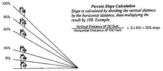
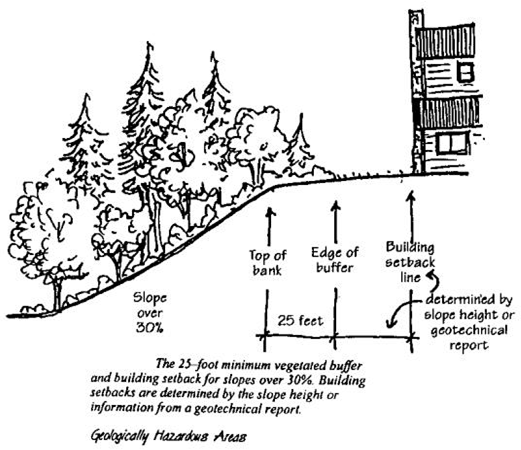
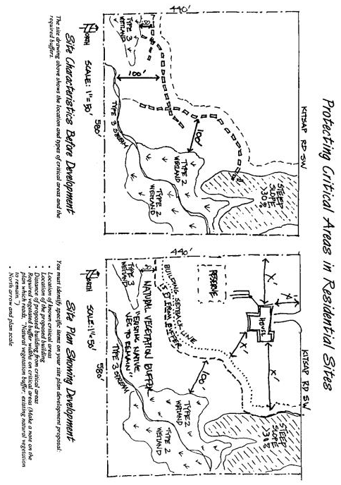
Attachment E – City of Port Orchard Critical Area and Buffer Notice
Return Address:
_____________________
_____________________
_____________________
CITY OF PORT ORCHARD
CRITICAL AREA AND BUFFER NOTICE
Legal Description Sec: _____ TWN: _____ RGE: _____
__________________________
Present Owner (Please Print): _____________
__________________________
Tax Account #: _________________________
NOTICE: The subject property contains a critical area and/or its buffer as defined by the City of Port Orchard as Critical Area Ordinance. The property was the subject of a development proposal for ____________________________, filed on ____________________.
(type of permit) (application)
Restrictions on use or alteration of the critical area and/or its buffer may exist due to natural conditions of the property and resulting regulations. Review of such application has provided information on the location of the critical area and/or its buffer and restrictions on their use through setback areas. A copy of the plan showing such setback areas is included in the above-referenced permit file. Any alterations to the critical area and/or its buffer shall be subject to further review for compliance with the City of Port Orchard Critical Areas Ordinance.
EXECUTED this ____ day of _____________, _______.
__________________________
__________________________
STATE OF WASHINGTON )
)
COUNTY OF KITSAP )
On this day personally appeared before me ____________________, to me known to be the individual(s) described in and who executed the within and foregoing instrument, and acknowledged that they signed the same as their free and voluntary act and deed, for the uses and purposes therein mentioned.
GIVEN under my hand and official seal the _____ day of ________________, _____.
NOTARY PUBLIC in and for the State of Washington,
RESIDING AT _________________________
Notary Seal
Attachment F – Kitsap County Shallow Principal Aquifer Listing
KITSAP COUNTY
SHALLOW PRINCIPAL AQUIFER LISTING
The following is a list of shallow principal aquifers that have been designated by an overlay as “Aquifer Recharge Areas of Concern.”
|
|
Approximate Elevations |
|---|---|
|
Og1a |
|
|
Hansville |
+250 |
|
Gorst |
+50 |
|
North Lake (McCormick Woods) |
+350 |
|
Port Gamble |
+100 |
|
|
|
|
Og2 |
|
|
Island Lake (upper) |
+150 |
|
Port Gamble South |
-50 |
|
Wilson Creek |
+150 |
|
|
|
|
Og3 |
|
|
Banger (upper) |
+100 |
|
Clam Bay |
0 |
|
Edgewater |
+130 |
|
Island Lake |
+150 |
|
Kinston (upper) |
-25 |
|
Poulsbo |
+225 |
|
Manette-Bremerton North |
0 |
|
Seabeck |
+100 |
|
Squamish-Miller Bay |
0 |
|
Yukon |
0 |
(Ord. 019-17 § 18 (Exh. 1)).
The Washington Geologic Information Portal is available online at https://www.dnr.wa.gov/geologyportal.