


Chapter 15
Definitions
SECTIONS:
15.1 General Information
For the purpose of this Master Program, certain terms and their derivations shall be construed as specified in this section. Some terms used in this Master Program may have a different definition and application under other City of Port Townsend regulations. Words in the singular include the plural, and the plural, the singular. The words "shall" and "will" are mandatory; the word "may" is permissive. Additional definitions applicable to this Master Program and adopted by reference herein, are found in RCW 90.58 and applicable sections of the Washington Administrative Code. The following definitions apply throughout this Program, unless otherwise indicated.
If a definition is not included here, the city shall rely on definitions found in applicable citations in the Revised Code of Washington (RCW), Washington Administrative Code (WAC), the Port Townsend Municipal Code (PTMC), and finally a standard dictionary, in that order. In case of conflict with PTMC, definitions within the RCW, WAC, and/or this Master Program shall prevail.
15.2 Definitions: A to B
Abandoned Over-water Structure
An over-water structure that has been abandoned and has fallen into a dilapidated state such that reuse of the structure will require repairs equal to or greater than 50% of it’s market value.
Abiotic – Not “biotic.” Accessory Building
A subordinate building attached to or detached from the principal building and used for purposes customarily incidental to the use of the principal building. Accessory buildings include but are not limited to an automobile storage garage, playhouse, laundry room, garden shelter, hobby room and mechanical room. (PTMC – Zoning – January 1, 2005).
Accessory Dwelling Unit
An accessory dwelling unit (ADU) is a habitable dwelling unit added to, created within, or detached from and on the same lot with a single family dwelling that provides basic requirements for living, sleeping, eating, cooking, and sanitation.
Accessory Use
A water-oriented or non-water-oriented use that is demonstrably subordinate and incidental to a water-oriented use; located on the same lot or in the same building as the water-oriented use; and which functionally supports its activity.
Accretion
The growth of a beach by the addition of material transported by wind and/or water. Included are such shoreforms as barrier beaches, points, spits, hooks and tombolos.

Act
The Shoreline Management Act of 1971, as amended (Chapter 90.58 RCW).
Activity
An occurrence associated with a use; the use of energy toward a specific action or pursuit. Examples of shoreline activities include but are not limited to fishing, swimming, boating, dredging, fish spawning, wildlife nesting, or discharging of materials.
Adaptive Reuse
Any change of use that is not considered a water-oriented use in a portion of any eligible building located in the Point Hudson Shoreline Designation. Adaptive reuses are limited to 30% of the total square footage of any eligible building and may include the uses specifically identified within the table of permitted uses for the Point Hudson Subdistricts.
[NOTE: The purpose of the adaptive reuse provision is to help revitalize and rehabilitate the existing coast guard buildings within the Point Hudson East subdistrict by facilitating the conversion of older, smaller spaces to viable uses that build on the character of the existing buildings and uses currently found within those buildings. Adaptive reuse is intended to help reduce vacant space in Point Hudson, rehabilitate historic and culturally significant buildings, and encourage an appropriate mix of water-enjoyment uses and visitor services.]
Adjacent Lands
Lands adjacent to the shorelines of the state (outside of shoreline jurisdiction). The SMA directs local governments to develop land use controls (i.e., zoning, comprehensive planning) for such lands consistent with the policies of the SMA, related rules and the local shoreline master program (see Chapter 90.58.340 RCW).
Administrator
The Port Townsend Development Services Director or his/her designee, charged with the responsibility of administering the Port Townsend Shoreline Master Program.
Advertising
Means any display of letters, numerals, characters, words, symbols, emblems, illustrations, objects or registered trademarks which serve to call to the attention of the public products, services, businesses, buildings, premises, events, candidates or ballot proportions (PTMC). On-premise advertising is that which is actually located on the site of the business or service advertised.
Agriculture
The cultivation of soil, production of crops, or the raising of livestock.
AKART
An acronym for "all known, available, and reasonable methods of prevention, control, and treatment" (WAC 173-201A-020). AKART shall represent the most current methodology that can be reasonably required for preventing, controlling, or abating the pollutants associated with a discharge. The concept of AKART applies to both point and nonpoint sources of pollution.
Alteration
Means any human-induced action that impacts the existing conditions of the area. Alteration includes but is not limited to:
Grading, filling, dredging, draining, channelizing, cutting, topping; Clearing, relocating or removing vegetation;
Paving, construction, modifying for surface water manage purposes;
Human activity that impacts the existing topography, vegetation, hydrology or wildlife habitat.
Alteration does not include walking, passive recreation or similar activities.
Anadromous Fish
Species, such as salmon, which are born in fresh water, spend a large part of their lives in the sea, and return to freshwater rivers and streams to procreate (e.g., salmon).
Applicable Master Program
The Master Program approved or adopted by the Washington State Department of Ecology pursuant to RCW 90.58.090 or RCW 90.58.190.
Appurtenance
A structure or development that is necessarily connected to the function and enjoyment of a single-family residence or other use and is located landward of the ordinary high water mark and the perimeter of a wetland. On a statewide basis, normal appurtenances include a garage; deck; driveway; utilities; fences; installation of a septic tank and drainfield and grading which does not exceed two hundred fifty (250) cubic yards and which does not involve placement of fill in any wetland or waterward of the ordinary high water mark.
Aquaculture
The culture or farming of food fish, shellfish, or other aquatic plants or animals, including the incidental preparation of these products for human use. The term encompasses a wide variety of activities including hatching, seeding, planting, cultivating, feeding, raising, and harvesting of plants and animals. Those activities that do not meet the definition of “development” in this Master Program (e.g., recreational hand harvesting) are not subject to shoreline permit requirements.
Aquatic
All water bodies, including marine waters, lakes, rivers, and streams and their respective water columns and underlying lands, which are defined as shoreline of the state.
Archaeology
The systematic recovery by scientific methods of material evidence remaining from man’s life and culture in past ages, and the detailed study of this evidence.
Artwork
As used in this Master Program, artwork means an original creation of visual art including but not limited to sculptures, fountains, ceramic tiles, and earthworks. Murals and structures (such as the Jackson Bequest or Wave Viewing Gallery) are excluded from this definition. See the City’s sign code for regulation of murals (17.76 PTMC). See “Structure”.
Associated Wetlands
Those wetlands that are in proximity to and either influence, or are influenced by tidal waters or a lake or stream subject to the Shoreline Management Act (WAC 173-22-030(1)).
Backshore
The area wetted by storm tides but normally dry between the coastline and the high tide line. It may be a narrow gravel berm below a sea bluff or a broader complex of berms, marshes, meadows, or dunes landward of the high tide line.
Bar
Similar to spits and hooks, though generally not attached to the mainland during periods of high water.
Barrier Beach
An accretion shore form of sand and gravel that has been deposited by longshore drift, like storm barriers, in front of bluffs, bays, marshes and estuaries.

Bathymetry, Bathymetrics
The measurement of water depth at various places in a body of water; also: the information derived from such measurements
- bathy·met·ric
Beach
The zone of unconsolidated material that is moved by waves, wind and tidal currents, extending landward to the coastline.
Beach feeding
A process by which beach material is deposited at one or several locations in the updrift portion of a driftcell. The material is then naturally transported by a wave’s down drift to stabilize or restore eroding beaches or berms.
Benthic/Benthos
Of or having to do with the bottom of oceans or seas. In biology, “benthos” meaning the organisms living on or in the bottom of oceans, lakes, or streams.
Berms
A linear mound of sand or gravel that is placed parallel to the shore at or above the ordinary high water mark. This may be a natural or a manmade feature.
Best Management Practices (BMPs)
BMPs are methods of improving water quality that can have a great effect when applied by numerous individuals. BMPs encompass a variety of behavioral, procedural, and structural measures that reduce the amount of contaminants in stormwater runoff and in receiving waters. The term "best management practices" is typically applied to nonpoint source pollution controls and is considered a subset of the AKART requirement.
Bioengineering
The practice of using natural vegetative materials to stabilize shorelines and prevent erosion. This may include use of bundles of stems, root systems, or other living plant material, soft gabions, fabric or other soil stabilization techniques, and limited rock toe protection where appropriate. Bioengineering projects often include fisheries habitat enhancement measures in project design (e.g., anchored logs, root wads, etc.).
Biota
The animals and plants that live in a particular location or region.
Bioengineering/biotechnical measures
Bioengineering is the term given to the practice of using natural vegetative materials to stabilize shorelines and prevent erosion. This may include use of bundles for stems, root systems, or other living plant material; soft gabions, fabric or other soil stabilization techniques; and limited rock toe protection where appropriate. The use of bioengineering as a shoreline stabilization technique is seen as an alternative to riprap, concrete and other structural solutions.
Biotic
Of or relating to life; especially: caused or produced by living beings.
Boat Launch or Ramp
Graded slopes, slabs, pads, planks, or rails used for launching boats by means of a trailer, hand, or mechanical device.
Boat Lift
A mechanical device that can hoist vessels out of the water for storage. These devices are usually located along a Boathouse
Boat House
A structure designed for storage of vessels located over water or in upland areas. Boathouses should not be confused with "houseboats.”
Boating Facilities
Boating facilities include marinas, both backshore and foreshore, dry storage and wet-moorage types, covered moorage, and marine travel lifts.
Bog
A shallow water area that may be filled by sedimentation and the decaying of vegetation [reference WAC 173-22-030(5)].
Breakwater
An off-shore structure generally built parallel to the shore that may or may not be connected to land. Its primary purpose is to protect a harbor, moorage, or navigational activity from wave and wind action by creating a still-water area along the shore. A secondary purpose is to protect the shoreline from wave-caused erosion.
Buffer
”Buffer” means an area on a landscape adjacent to any critical area which:
1. Physically isolates the critical area from surrounding areas using distance, height, visual and/or sound barriers;
2. Acts to minimize risk to the public from loss of life, well-being or property damage resulting from natural disasters associated with the critical area;
3. Protects the functions and values of the critical area from adverse impacts of adjacent activities;
4. Provides shading, input of organic debris and coarse sediments, room for variation and changes in natural critical area characteristics;
5. Provides habitat for wildlife; and/or
6. Provides protection from harmful intrusion.
All of these buffer functions protect the public from losses suffered when the functions and values of critical areas are degraded.
(Also See “Setbacks”).
Building
Any structure having a roof supported by columns or walls used or intended to be used for the shelter or enclosure of any use or occupancy. (different but consistent with PTMC)
Building Height – see Height
Bulkhead
A solid or open pile wall usually constructed parallel to the shore whose primary purpose is to contain and prevent the loss of soil by erosion, wave, or current action. Bulkheads are used to protect marine bluffs by retaining soil at the toe of the slope or by protecting the toe of the bank from erosion and undercutting. Bulkheads are typically constructed of poured-in-place concrete, steel or aluminum sheet piling, wood, or wood and structural steel combinations.
Bulkheads are normally lighter than a seawall and similar to structures termed "Revetments" defined below.
Buoy
Buoys are floating devices anchored in a waterbody for navigational purposes or moorage. See also “Mooring Buoy.”
15.3 Definitions: C to F
Campground
An outdoor area established for overnight accommodation of recreational user.
Channel
An open conduit for water either naturally or artificially created, but does not include artificially created irrigation, return flow, or stock watering channels. See also “Stream”.
City
The incorporated City of Port Townsend, Washington.
Clearing
The destruction or removal of vegetation, ground cover, shrubs and trees including, but not limited to, root material removal that affects the erosive potential of the soils on the site. This includes such activities as clear-cutting or selective harvest of trees, chipping of stumps and hauling off of shrubs, slash piles, etc.
Coastline
The highest landward line of long-term marine water effect upon the land.
Covered Moorage
Boat moorage, with or without walls, that has a roof to protect the vessel.
Commercial
Commercial developments are those uses that are involved in wholesale, retail, service or business trade activities. Examples include but are not limited to hotels, motels, grocery stores, restaurants, shops, offices, visitor’s centers, government or other offices, and indoor recreation facilities.
Comprehensive Plan
Comprehensive Plan means the document, including maps, adopted by the city council that outlines the City’s goals and policies relating to management of growth, and prepared in accordance with Ch. 36.70A RCW. The term also includes adopted subarea plans prepared in accordance with Ch. 36.70A RCW.
Conditional Use
A use, development, or substantial development that is classified as a conditional use or is not classified within the applicable master program. Refer to WAC 173-27-030(4).
Conservancy
An area with valuable natural, cultural, or historical resources.
County
Jefferson County, Washington.
Creek
A small stream; often a shallow or intermittent tributary to a river. Surface water run-off flowing in a natural or modified channel that is drawn by gravity to progressively lower levels and eventually to the sea.
Critical Areas
For the purposes of this Master Program, "critical areas" include aquifer recharge areas, fish and wildlife habitat conservation areas, frequently flooded areas and critical drainage corridors, geologically hazardous areas, wetlands and streams. Under the GMA, critical areas are to be classified, designated and protected. In designating and protecting critical areas, the city shall use the best available science, consistent with RCW 36.70A.172.
Cumulative Impact
The impact on the environment which results from the incremental impact of the action when added to other past, present, and reasonably foreseeable future actions regardless of what agency or person undertakes such other actions. Cumulative impacts can result from individually minor but collectively significant actions taking place over a period of time.
Development
A use consisting of the construction or exterior alteration of structures; dredging; drilling; dumping; filling; removal of any sand, gravel, or minerals; bulkheading; driving of piling; placing of obstructions; or any other project of a permanent or temporary nature which interferes with the normal public use of the surface of the waters overlying lands subject to the Act at any state of water level (RCW 90.58.030(3d)).
See also “Substantial Development.”
Dock
A dock or pier is a landing and moorage facility for watercraft that abuts the shoreline and does not include recreational decks, storage facilities, or other appurtenances.
Downdrift
The direction of movement of beach materials.
Dredge Spoil or Dredge Material
The material removed by dredging.
Dredging
The removal of earth, sand, gravel, silt, or debris from the bottom of a stream, river, lake, bay, or other water body and associated wetlands.
Drift cell
Drift cell is a term used to describe a geographic unit along the shore. Each begins at a sediment source along an eroding shoreline, often at the base of “feeder bluffs”. Sediment is transported within the drift cell by currents and wind-blown waves, finally being deposited at an accretion shore form (e.g., spits, sandbars, accretion beach) marking the end of the drift cell. See “Accretion” and “Feeder Bluff”.
Driftway
The foreshore area that connects a feeder bluff and its accretion from where sand or gravel is deposited by net effect of wave action and longshore drifts.
Dwelling
Any building or portion thereof designed or used primarily for residential occupancy, including single-family dwellings, duplexes, triplexes, fourplexes, and multifamily dwellings, but not including hotels or motels.
Dwelling, multifamily
A building containing five or more dwelling units, including units that are located one over the other.
Dwelling, single-family
In considering shoreline exemptions, single-family dwelling means a structure designed for and occupied exclusively by one family and the household employees of that family (i.e., it does not include duplex, triplex, or fourplex).
Ecological Functions
"Ecological functions" or "shoreline functions" means the work performed or role played by the physical, chemical, and biological processes that contribute to the maintenance of the aquatic and terrestrial environments that constitute the shoreline’s natural ecosystem. See WAC 173-26-200 (2)(c).
The beneficial roles served by ecological functions include, but are not limited to, water quality protection and enhancement, fish and wildlife habitat, food chain support, flood storage, conveyance and attenuation, ground water recharge and discharge, erosion control, wave attenuation, protection from hazards, historical and archaeological and aesthetic value protection, educational opportunities, and recreation.
These beneficial roles are not listed in order of priority. Functions can be used to help set targets (species composition, structure, etc.) for managed areas, including mitigation sites.
Economic Development
A development that provides a service, produces a good, retails a commodity, or engages in any other use of activity for the purpose of making financial gain.
Ecosystem-wide processes
The suite of naturally occurring physical and geologic processes of erosion, transport, and deposition; and specific chemical processes that shape landforms within a specific shoreline ecosystem and determine both the types of habitat and the associated ecological functions.
Eligible Buildings
For the purposes of the Port Townsend Shoreline Master Program, “eligible buildings” refers to the following buildings in the Point Hudson Shoreline Designation that are allowed to have adaptive uses in a portion of the building:
Hospital
Main Building
Shower Building
Emergency
An unanticipated and imminent threat to public health, safety, or the environment which requires immediate action within a time too short to allow full compliance with the Master Program. Emergency construction is construed narrowly as that which is necessary to protect property from the elements (RCW 90.58.030(3eiii) and WAC 173-27- 040(2d)). See also “Substantial Development”.
Enhancement
Enhancement means an action approved by the Shoreline Administrator and taken with the intention and probable effect of improving the condition and function of a shoreline area, such as improving environmental functions in an existing, viable, shoreline habitat by means of increasing plant diversity, increasing wildlife habitat, installing environmentally compatible erosion controls, or removing nonindigenous plant and/or animal species.
Or -Alteration of an existing resource to improve or increase its characteristics and processes without degrading other existing functions. Enhancements are to be distinguished from resource creation or restoration projects.
Environmental Impacts
The effects or consequences of actions on the natural and built environments. Environmental impacts include effects upon the elements of the environment listed in the State Environmental Policy Act (SEPA) (WAC 197-11-600 and WAC 197-11-444)
Environment(s) (Shoreline Environment(s))
Designations given specific shoreline areas based on the existing development pattern, the biophysical capabilities and limitations, and the goals and aspirations of local citizenry, as part of a Master Program.
Erosion
The group of natural processes including weathering, dissolution, abrasion, corrosion, and transporting by which earthy or rocky material is removed from any part of the earth’s surface.
Esplanade
A level stretch of ground, especially a public walk or walkway.
Estuary
That portion of a coastal stream influenced by the tide of marine waters into where it flows and where the seawater is diluted with fresh water derived from land drainage.
Exempt Development
Certain specific developments as listed in WAC 173-27-040 are exempt from the definition of substantial development and therefore exempt from the substantial development permit process of the SMA. An activity that is exempt from the substantial development provisions of the SMA must still be carried out in compliance with policies and standards of the Act and the local master program. Conditional use and/or variance permits may also still be required even though the activity does not need a substantial development permit (RCW 90.58.030(3e).
Extreme Low Tide
The lowest line of the land reached by a receding tide.
Fair Market Value
"Fair market value" of a development is the open market bid price for conducting the work, using the equipment and facilities, and purchase of the goods, services and materials necessary to accomplish the development. This would normally equate to the cost of hiring a contractor to undertake the development from start to finish, including the cost of labor, materials, equipment and facility usage, transportation and contractor overhead and profit. The fair market value of the development shall include the fair market value of any donated, contributed or found labor, equipment, or materials.
Feasible
Pursuant to the Shoreline Guidelines (WAC 173-26), feasible means that an action, such as a development project, mitigation, or preservation requirement, meets all of the following conditions:
(a) The action can be accomplished with technologies and methods that have been used in the past in similar circumstances, or studies or tests have demonstrated in similar circumstances that such approaches are currently available and likely to achieve the intended results;
(b) The action provides a reasonable likelihood of achieving its intended purpose; and
(c) The action does not physically preclude achieving the project’s primary intended legal use.
In cases where these guidelines require certain actions unless they are proven to be infeasible, the burden of proving infeasibility is on the applicant.
In determining an action’s infeasibility, the reviewing agency may weigh the action’s relative public costs and public benefits, considered in the short- and long-term time frames.
Feeder Bluff
A shore or sea bluff whose eroding material is transported by longshore drift and provides the building blocks and nourishment for spits, bars, hooks, and other accretion shore forms.

First Class Tidelands
The beds and shores of navigable tidal waters lying within or in front of the corporate limits of any city, or within one mile thereof, upon either side and between the line of ordinary high tide and the inner harbor line, and within two miles of the corporate limits on either side and between the line of ordinary high tide and the line of extreme low tide.
Float
A floating structure, not connected to the shoreline, that is moored, anchored, or otherwise secured in the water that is not connected to the shoreline.
Flood Control
Any undertaking for the conveyance, control, and dispersal of floodwaters caused by abnormally high direct precipitation or stream overflow.
Floodplain
A term synonymous with the hundred-year floodplain, meaning that land area susceptible to being inundated by stream derived waters with a one percent chance of being equaled or exceeded in any given year. The limit of this area shall be based upon flood ordinance regulation maps or a reasonable method that meets the objectives of the Shoreline Management Act.

Functions and Values (see “Ecological Functions”)
15.4 Definitions: G to O
Gabions
Structures composed of masses of rocks, rubble or masonry held tightly together usually by wire mesh so as to form blocks or walls. Sometimes used on heavy erosion areas to retard wave action or as foundations for breakwaters or jetties.
Geomorphology
The science dealing with the relief features of the earth and the processes influencing their formation.
GMA
Growth Management Act – Washington State House Bill 2929 adopted in 1990 and amendments thereto. Codified largely within Chapter 36.70A RCW.
Grading
The movement or redistribution of the soil, sand, rock, gravel, sediment, or other material on a site in a manner that alters the natural contour of the land.
Grassy Swale
A vegetated drainage channel that is designed to remove various pollutants from storm water runoff through biofiltration.
Groin
A barrier-type structure extending from the backshore or stream bank into a water body. The purpose of a groin is to interrupt sediment movement along the shore. A groin is also referred to as a rock weir.
Habitat
The place or type of site where a plant or animal naturally or normally lives and grows.
Harbor Area
The area of navigable tidal waters as determined in Section 1 of Article 15 of the Washington State constitution, which shall be forever reserved for landings, wharves, streets, and other conveniences of navigation and commerce.
Hearing Examiner (Land Use)
The Hearing Examiner of the City of Port Townsend.
Hearings Board
The state shorelines hearings board established by the Act.
Height, Building
Please refer to the Port Townsend Municipal Code Chapter17.08]
Historic
Having considerable importance or influence in history; historical.
HPA - Hydraulic Project Approval.
The permit issued by the Washington State Department of Fish and Wildlife pursuant to the State Hydraulic Code Chapter 75.20.100-140 RCW.
Hydraulic Continuity
Hydric Soil
Hydric soil means soil that formed under conditions of saturation, flooding, or ponding long enough during the growing season to develop anaerobic conditions in the upper soil horizon(s), thereby influencing the growth of plants.
Hydrophytes
Plants capable of growing in water or on a substrate that is al least periodically deficient in oxygen as a result of excessive water content. See also Marshes, Bogs, and Swamps
Industry
The production, processing, manufacturing, or fabrication of goods or materials. Warehousing and storage of materials or production is considered part of the industrial process.
Inner Harbor Line
A line located and established in navigable tidal waters between the line of ordinary high tide and the outer harbor line and constituting the inner boundary of the harbor area.
In-kind Replacement
To replace wetlands, biota or other organisms with substitute flora or fauna whose characteristics closely match those destroyed, displaced, or degraded by an activity.
Jetty
A structure generally perpendicular to the shore, extending through or past the intertidal zone. Jetties are built singly or in pairs at a harbor entrance or river mouth mainly to prevent accretion from littoral drift in an entrance channel, which may or may not be dredged. Jetties also serve to protect channels from storm waves or cross currents and to stabilize inlets through barrier beaches. On the Pacific Coast, most jetties are of rip-rapped, mound construction.
Lake
A body of standing water in a depression of land or expanded part of a river, including reservoirs, of twenty (20) acres or greater in total area. A lake is bounded by the ordinary high water mark or, where a stream enters a lake, the extension of the elevation of the lake’s ordinary high water mark within the stream (RCW 90.58.030(1d); WAC 173-22-030(9)).
Landfill
The creation of or addition to a dry upland area by depositing material into waters or onto shorelines or wet land areas.
Landscaping
Vegetative ground cover including shrubs, trees, flower beds, grass, ivy and other similar plants and including tree bark and other materials which aid vegetative growth and maintenance.
LID, Low-Impact Development
Low impact development is a stormwater management and land development strategy applied at the parcel and subdivision scale that emphasizes conservation and use of on-site natural features integrated with engineered, small-scale hydrologic controls to more closely mimic predevelopment hydrologic functions.
Littoral Drift
The mud, sand, or gravel material moved parallel to the shoreline in the nearshore zone by waves and currents.
Marina
A facility that provides launching, storage, supplies, moorage, and other accessory services for six or more pleasure and/or commercial water craft.
Marine Bluff
Steep slopes formed and maintained by marine wave action. Marine bluffs include those marine bluffs that have been modified by bulkheads or railroads (e.g., along Larry Scott Memorial Trail).
Excluded from this definition are steep slopes that have been significantly removed from wave action due to the evolution of spits, lagoons, and protected marshes (e.g., bluffs along Washington Street downtown and above the campground at Fort Worden) or due to intervening, legal non-conforming development that eliminates wave action (e.g., bluffs behind Water Street between the Washington State Ferry terminal and Kearny Street).
Marshes, Bogs, and Swamps
As defined in WAC 17-22-030(5), "marshes, bogs, and swamps" are lands transitional between terrestrial and aquatic systems where saturation with water is the dominant factor determining plant and animal communities and soil development. For the purposes of this definition, these areas must have one or more of the following attributes:
a) At least periodically, the land supports predominantly hydrophytes; and/or
b) The substrate is predominantly undrained hydric soils. Hydrophytes include those plants capable of growing in water or on a substrate that is at least periodically deficient in oxygen as a result of excessive water content. Hydric soils include those soils that are wet enough to periodically produce anaerobic conditions, thereby influencing the growth of plants.
Master Program
The comprehensive management plan for a described shoreline and water surface area and the use regulation together with maps, diagrams, charts, or other descriptive material and text; a statement of desired goals and standards developed in accordance with the policies enunciated in RCW 90.58.020 and its guidelines under WAC 173-14 and 173-16, as amended.
Mining
The removal of naturally occurring rock, sand, gravel, and minerals from the earth.
Mitigation or Mitigation Sequencing
The process necessary to avoid, minimize or reduce, or compensate for the environmental impact(s) of a proposal (see WAC 197-11-768 and WAC 173-26-020 (30)). Mitigation or mitigation sequencing means the following sequence of steps listed in order of priority, with (a) of this subsection being top priority:
a) Avoiding the impact altogether by not taking a certain action or parts of an action;
b) Minimizing impacts by limiting the degree or magnitude of the action and its implementation by using appropriate technology or by taking affirmative steps to avoid or reduce impacts;
c) Rectifying the impact by repairing, rehabilitating, or restoring the affected environment;
d) Reducing or eliminating the impact over time by preservation and maintenance operations;
e) Compensating for the impact by replacing, enhancing, or providing substitute resources or environments; and
f) Monitoring the impact and the compensation projects and taking appropriate corrective measures.
Mixed-use Development
Mixed-use developments are projects that include water-dependent uses combined with water-related uses, water-enjoyment uses and/or non-water-oriented uses. Mixed-use developments can be a tool for increased water-dependent activities, civic revitalization, and public access to the shoreline. To encourage mixed-use projects that achieve a public benefit, special provisions can be included in a master program that offer a potential developer incentives or more latitude than normal master program requirements. In return, the developer’s proposal must include elements that further the objectives of he Shoreline Management Act and benefit the public. Implicit in the concept of mixed-use provisions is that additional development incentives must be justified by increased and long-term public benefit resulting from the project and that the public benefit must relate to SMA objectives. Generally in mixed-use projects the water-oriented uses and non-revenue recreation uses are “subsidized” by the economic advantages of the other uses in the sense that the water- oriented uses could not be economically developed without support from viable water-enjoyment or non-water-oriented uses.
Moorage
Any device or structure used to secure a vessel for temporary anchorage, but which is not attached to the vessel (such as a dock or buoy).
Moorage Piles
Structural members that are driven into the lake bed to serve as a stationary moorage point. They are typically used for moorage of small boats in the absence of, or instead of, a dock or pier. In some cases, moorage piles may be associated with a dock or pier.
Mooring Buoy
A floating object anchored to the bottom of a water body that provides tie up capabilities for vessels.
Multiple-Use
The combining of compatible uses within one development.
Native Plants or Native Vegetation
Plant species that are indigenous to the Olympic Peninsula.
Natural
A shoreline possessing unique or fragile features, whether natural or cultural, that are totally or essentially unaltered from their natural state or are relatively intolerant of human use other than for passive historical, cultural, scientific, archaeological, or educational activity.
Natural or Existing Topography
The topography of the lot, parcel, or tract of real property immediately prior to any site preparation or grading, including excavation or filling.
Navigable Waters
Those waters lying waterward of and below the line of navigability on lakes not subject to tidal flow, or extreme low tide mark in navigable tidal waters, or the outer harbor line where harbor area has been created.
Non-conforming Use or Development
A shoreline use or structure or portion thereof which was lawfully constructed or established prior to the effective date of the Shoreline Management Act or local shoreline master program provision, or amendments, but no longer conforms to the policies and regulations of this Master Program.
Non-water-oriented Use
A use that has little or no relationship to the shoreline and is not considered a priority use under the Shoreline Management Act. All uses which do not meet the definition of water-dependent, water- related, or water-enjoyment are classified as non-water-oriented uses. Examples of non-water-oriented uses include professional offices, general retail or commercial uses, residential development, and mini- storage facilities.
Normal Maintenance
Those usual acts to prevent a decline, lapse, or cessation from a lawfully established condition (WAC 173-27-040(2b)). See also “Normal Repair”.
Normal Protective Bulkhead
A bulkhead, common to single-family residences, constructed at or near the ordinary high water mark to protect an existing single-family residence, and which sole purpose is for protecting land from erosion, not for the purpose of creating new land (WAC 173-27-040(2c).
Normal Repair
Activities that restore the character, size or scope of a project only to the previously authorized condition within a reasonable period after decay or partial destruction, excepting that repair involving total replacement which is not common practice or causes substantial adverse effects to the shoreline resource or environment shall not be construed as normal repair (WAC 173-27-040(2b) See also “Normal Maintenance”.
Noxious Weed
Any plant that is invasive, such as Himalayan blackberries, Scotch broom, Spartina, and listed on the state noxious weed list in Chapter 16-750 WAC.
NWMC – Northwest Maritime Center
Offshore
The sloping subtidal area seaward from the low tideland.
Offshore Moorage Device
An offshore device anchored or otherwise attached to the sea bottom used to moor water craft.
Off-site Compensation
To compensate for lost or degraded wetlands or other shoreline environmental resources by creating or restoring these areas on lands other than the site on which the impacts were located
OHWM (Ordinary High Water Mark)
On-site Compensation
To compensate for lost or degraded wetlands or other shoreline environmental resources by creating or restoring these areas at or adjacent to the site on which the impact were located.
Out-of-kind compensation
To compensate for lost or degraded wetlands or other shoreline environmental resources by creating substitute habitat whose characteristics do not closely approximate those lost or degraded by a development activity.
One-hundred-year Flood
The maximum flood expected to occur during a one-hundred-year period.
Open Space
A land area allowing view, use or passage that is almost entirely unobstructed by buildings, paved areas, or other man-made structures.
Ordinary High Water Mark (often abbreviated OHWM)
That mark on all lakes, streams, and tidal waters that will be found by examining the bed and banks and ascertaining where the presence and action of waters are so common and usual, and so long continued in all ordinary years, as to mark upon the soil a character distinct from that of the abutting upland in respect to vegetation as that condition exists on June 1, 1971 or as it may naturally change thereafter; or as it may change thereafter in accordance with permits issued by the local government or the Washington State Department of Ecology; provided that in any area where the ordinary high water mark cannot be found, the ordinary high water mark adjoining salt water shall be the line of mean higher high tide, and the ordinary high water mark adjoining fresh water shall be the line of mean high water.
Outer Harbor Line
A line located and established in navigable waters as provided in Section 1 of Article 15 of the Washington State Constitution, beyond which the state shall never sell or lease any rights whatsoever.
Over-water Structure
Any device or structure located waterward of the ordinary high water mark, including, but not limited to piers, docks, floats, and moorage or anchor buoys and buildings constructed on piers or perimeter rock foundations (e.g. Cannery, City Dock, Admiralty Apartments).
Existing legally established buildings constructed on fill or on a continuous concrete foundation that are located waterward of what would otherwise be the OHWM (e.g. Duncan-Kellog building, Waterman Katz, C.C. Bartlett Building, Hastings Building are not considered over water structures under this Master Program.
15.5 Definitions: P to R
Parking Space or Parking Stall
Areas providing for the storage of motor vehicles, including vista- parking facilities. Excepting however, that this definition shall not apply to vehicle holding areas necessary to support a publicly operated ferry system.
Performance Standard
Regulations, which include bulk and dimensional standards that are applied to the design and function of a development or use.
Permit (or Shoreline Permit)
Any substantial development, variance or conditional use permit, or revision, or any combination thereof, authorized by the Act (WAC 173-27-030(13)).
Person
An individual, firm, partnership, corporation, association, organization, agency, or any non-federal entity however designated.
Pier
A fixed, pile-supported structure.
Pocket Beach
In this Master Program, pocket beach refers to an isolated accretion beach bordered by shoreline modifications.
Point
A low profile beach promontory, generally of triangular shape whose apex extends seaward.
Point Hudson Station Buildings
Buildings in the Point Hudson Marina district dating from the 1930’s when Point Hudson was used as a federal quarantine station or from the 1940’s when Point Hudson served as a Coast Guard station and U.S. Army training base.
Pollutant
Any substance that has been or may be determined to cause or tend to cause injurious, corrupt, impure, or unclean conditions when discharged to surface water, air, ground, sanitary sewer system, or storm drainage system.
Port
A center for water-borne commerce and traffic.
Practicable Alternative
An alternative that is available and capable of being carried out after taking into consideration short-term and long-term cost, existing technology, options of project scale and phasing, and logistics in light of overall project purposes, and having less impacts to environmentally sensitive areas. It may include using an area not owned by the applicant that can reasonably be obtained, utilized, expanded or managed in order to fulfill the basic purpose of the proposed development.
Priority habitat
A habitat type with unique or significant value to one or more species. An area classified and mapped as priority habitat must have one or more of the following attributes:
• Comparatively high fish or wildlife density;
• Comparatively high fish or wildlife species diversity;
• Fish spawning habitat;
• Important wildlife habitat;
• Important fish or wildlife seasonal range;
• Important fish or wildlife movement corridor;
• Rearing and foraging habitat;
• Important marine mammal haul-out;
• Refuge habitat;
• Limited availability;
• High vulnerability to habitat alteration;
• Unique or dependent species; or
• Shellfish bed.
A priority habitat may be described by a unique vegetation type or by a dominant plant species that is of primary importance to fish and wildlife (such as oak woodlands or eelgrass meadows). A priority habitat may also be described by a successional stage (such as, old growth and mature forests). Alternatively, a priority habitat may consist of a specific habitat element (such as a consolidated marine/estuarine shoreline, caves, snags) of key value to fish and wildlife. A priority habitat may contain priority and/or non-priority fish and wildlife.
Priority species
Species requiring protective measures and/or management guidelines to ensure their persistence at genetically viable population levels.
Priority species are those that meet any of the criteria listed below.
(a) Criterion 1. State-listed or state proposed species. State-listed species are those native fish and wildlife species legally designated as endangered (WAC 232-12-014), threatened (WAC 232-12-011), or sensitive (WAC 232-12-011). State proposed species are those fish and wildlife species that will be reviewed by the department of fish and wildlife (POL-M-6001) for possible listing as endangered, threatened, or sensitive according to the process and criteria defined in WAC 232- 12-297.
(b) Criterion 2. Vulnerable aggregations. Vulnerable aggregations include those species or groups of animals susceptible to significant population declines, within a specific area or statewide, by virtue of their inclination to congregate. Examples include heron colonies, seabird concentrations, and marine mammal congregations.
(c) Criterion 3. Species of recreational, commercial, and/or tribal importance. Native and nonnative fish, shellfish, and wildlife species of recreational or commercial importance and recognized species used for tribal ceremonial and subsistence purposes that are vulnerable to habitat loss or degradation.
(d) Criterion 4. Species listed under the federal Endangered Species Act as either proposed, threatened, or endangered.
Priority Use
The Shoreline Management Act and this Master Program give preference to shoreline uses that are water-dependent or water-related, provide public access and recreational use of the shoreline, as well as other uses which provide an opportunity for substantial numbers of people to enjoy the shoreline and to single-family residences (See RCW 90.58.020)
Proposed, Threatened and Endangered (PTE) Species
Those native species that are proposed to be listed or are listed in rule by the Washington State Department of Fish and Wildlife as threatened or endangered, or that are proposed to be listed as threatened or endangered or that are listed as threatened or endangered under the federal Endangered Species Act.
Public Access
A means of physical approach to and along the shoreline available to the general public. This may also include visual approach. Provision of public access is a not for profit activity.
Public Interest
The interest shared by the citizens of the state or community at large in the affairs of government, or some interest by which their rights or liabilities are affected such as an effect on public property or on health, safety, or general welfare resulting from a use or development.
[WAC 173-27-030(14)]
Public Use
Public use means to be made available daily to the general public on a first-come, fist-served basis, and may not be leased to private parties on any more than a day use basis. (WAC 332-30-106)
RCW
Revised Code of Washington.
Recreational Facilities
Facilities such as parks, trails and pathways, campgrounds, and swim rafts that provide a means for relaxation, play, or amusement. For the purposes of this Master Program, recreational uses are divided into two categories:
1. Water-dependent (e.g., boating facilities, fishing pier, swim rafts) and
2. Non-water-dependent. Non water-dependent recreational uses are further divided into three subcategories based on their relative impact to the shoreline environment:
a. High Intensity recreational uses require substantial development/ land modification or large areas of fertilized lawn. Such uses may include but are not limited to camp grounds, sport courts (e.g., tennis/basketball), golf course, sport fields (e.g., ball park), aquatic center, skateboard park.
b. Moderate Intensity recreational uses are typified by formal parks for passive recreation (e.g., Chetzamoka and Pope Marine Parks) requiring some modification of natural conditions, limited paving and often including accessory structures (e.g., picnic shelters, restrooms, viewing galleries, gazebos, playground equipment.
c. Low intensity recreational uses are passive in nature (e.g., walking, photography, wildlife viewing) and require very minimal alteration of natural conditions. Such uses/modifications may include but are not limited to non-motorized trails, vista points, wildlife viewing areas, picnic tables and benches.
Recycling Facilities
Recycling facility means a facility for the collection and/or sorting and storage of recyclable materials generated from domestic or small business sources, such as bottles, cans, paper, cardboard, aluminum, and plastics. This definition does not include facilities for the processing of recyclable materials, which are classified as a manufacturing use. Recycling facilities are further divided into two categories:
A. Major recycling facilities include facilities primarily dedicated to the collection, sorting, or purchase and resale of recyclable materials.
B. “Minor recycling facilities include bins or other temporary or permanent facilities for the collection of small quantities of recyclable materials to be sorted and/or processed elsewhere. A minor facility may be accessory to a primary use, such as a recycling bin at a grocery store parking lot.
Remodel, minor –
A minor remodel neither changes an existing foundation line (i.e., no site alterations) nor increases the existing square footage of a structure by more than 25%;
Repair (See Normal Repair) Residence (See Dwelling)
Residential Development
The development of land and/or construction or erection of dwelling units for the purpose of residential occupancy, but not including occupancy of a transient nature such as in hotels, motels, or time- sharing condominium uses.
Restaurant
An establishment where food and drink are prepared, served and consumed primarily within the principal building. Restaurants may qualify as a water-enjoyment use when located, designed and operated to assure the public’s ability to interact with the shoreline. Water-enjoyment design elements may include the incorporation of outdoor seating areas that are compatible with shoreline public access. Drive-thru restaurants are not considered water-enjoyment uses and are prohibited in the shoreline designation.
Restore, restoration or ecological restoration
Means the reestablishment or upgrading of impaired ecological shoreline processes or functions. This may be accomplished through measures including, but not limited to, revegetation, removal of intrusive shoreline structures and removal or treatment of toxic materials. Restoration does not imply a requirement for returning the shoreline area to aboriginal or pre-European settlement conditions (WAC 173-26-020(27)).
Restoration of ecological functions and values, above and beyond that which may be required as mitigation for project impacts, are considered a water-dependent use under this master program.
Retrieval Lines
A system by which a float or other floating object is retrieved to a pier, dock, or shoreland.
Revegetation
The planting of vegetation to cover any land areas that have been disturbed during construction. This vegetation shall be maintained to insure its survival and shall be consistent with planting requirements of the Port Townsend Landscape Code.
Revetment
A revetment is a sloped shoreline structure built to protect an existing eroding shoreline or newly placed fill against currents and wave action. Revetments are most commonly built of randomly placed boulders (riprap) but may also be built of sand cement bags, paving, or building blocks, gabions (rock filled wire baskets) or other systems and materials. The principal features of a revetment, regardless of type is a heavy armor layer, a filter layer, and toe protection. See also “bulkheads.”
Riprap
A layer, facing, or protective mound of stone placed on shoulders, slopes, or other such places to protect them from erosion, scour, or sloughing of a structure or embankment; also, the stone so used.
Rock Weir
A structure made of loose rock that is designed to control sediment movement, water flow, or both. A rock weir adjacent to a shoreline is typically formed by placing rock in a line outward from the shore, with the top of the rock embankment below the water level to restrict current movements parallel to the shore without completely blocking flow.
Runoff
Water that is not absorbed into the soil but rather flows along the ground surface following the topography.
15.6 Definitions S to T
Sediment
The fine-grained material deposited by water or wind.
SEPA
See State Environmental Policy Act.
SEPA Checklist
A checklist is required of some projects under SEPA to identify the probable significant adverse impacts on the quality of the environment. The checklist will also help to reduce or avoid impacts from a proposal, and help the responsible governmental agency decide whether a full environmental impact statement (EIS) is required (WAC 197-11-960).
Scientific, Cultural and Educational Facilities
Those sites, structures, or facilities that provide unique insight into our natural and cultural heritage.
Sea wall
A bulkhead, except its primary purpose is to artificially armor the shore from erosion by water waves and it may incidentally retain uplands or fills. Sea walls are usually more massive than bulkheads or revetments because they are designed to resist the full force of waves.
Second Class Shoreland
Land bordering on the shore of a navigable lake or river not subject to tidal flow, between the line of ordinary high water and the line of navigability and within or in front of the corporate limits of any city or within two miles thereof upon either side.
Second Class Tideland
Land over which the tide ebbs and flows outside and more than two miles from the corporate limits of any city from the line of ordinary high tide to the line of extreme low tide.
Setbacks
“Setback (yard requirements)” means the distance between a building and its lot lines. Setbacks shall be measured, where applicable, from building lines to the proposed or actual public or private street right- of-way lines.
Shoreline Environment Setbacks – the distance between a building or use and the ordinary-high water-mark (OHWM) as established for each specific environmental designation under Chapter 5of this Master Program.
Shall
"Shall,” indicates a mandate; the particular action must be done.
Shore Defense Works
Structures or modifications for the purpose of retarding shore erosion from waves or current action, protecting channels and harbors from wave action, encouraging deposition of beach materials, preventing stream bank overflow, and retaining uplands. They may consist of bulkheads, seawall, dikes, revetments, breakwaters, jetties, groins, or gabions. Defense works are commonly constructed from quarry rock (rip-rap), treated wood, concrete, steel, and sand and gravel.
Shoreland Areas or Shorelands
Those lands extending landward for two hundred (200) feet in all directions as measured on a horizontal plane from the ordinary high water mark, including all wetlands associated with the shoreline which are subject to the provisions of this chapter; the same to be designated as to location by the Washington Department of Ecology.
Shoreline Administrator
See Administrator.
Shoreline Environment(s)
See Environment
Shoreline Management Act of 1971
A law passed by the Washington State Legislature in 1971 and ratified by the voters in 1972 (reference RCW 90.58).
Shoreline Permit
A permit to conduct a development or use as defined by RCW 90.58 and this Master Program. A shoreline permit means any form of permission required under RCW 90.58 prior to undertaking activity on shorelines of the state, including substantial development, conditional use or variance permits.
Shoreline Setback Line
Unless otherwise indicated within this Master Program, the line which establishes the limits of all buildings, structures and fencing along the shoreline. Setback lines are based upon land use patterns while setbacks associated with buffers are intended to protect critical areas (See “buffer areas”).
Shoreline setbacks are measured perpendicularly from the ordinary high water mark (OHWM) to the wall of the structure (s); PROVIDED that where a structure has not wall, the setback is measured to the post(s) or, if the structure has no posts, a point that is two (2) feet under the roof overhang measured from the drip line of the roof.
Shorelines
All the water area of Port Townsend, including reservoirs and their associated wetlands, together with lands underlying them, except:
a. Shorelines of statewide significance.
b. Shorelines or segments of streams upstream of a point where the mean annual flow is twenty cubic feet per second or less and the wetlands associated with such upstream segments.
c. Shorelines on lakes less than twenty acres in size and wetlands associated with such small lakes.
Shorelines Hearings Board
A state-level quasi-judicial body, created by the SMA, which hears appeals by any aggrieved party on the issuance of a shoreline permit, enforcement penalty and appeals by local government on DOE approval of master programs, rules, regulations, guidelines or designations under the SMA. See RCW 90.58.170; 90.58.180; and WAC 173-27-220 and 173-27-290.
Shorelines of the State
The total of all shorelines and shorelines of statewide significance.
Shorelines of Statewide Significance
A shoreline of the state with respect to the City of Port Townsend as identified as follows: Those areas of Puget Sound and the Strait of Juan de Fuca and adjacent salt waters north to the Canadian line and lying seaward from the line of extreme low tide.
Sign
Any visual communication device, structure, placard or fixture that uses color, form, graphic, illumination, symbol, or writing to advertise, announce the purpose of, or identify the purpose of a person or entity, or to communicate information of any kind to the public. For the purpose of this chapter, a sign is not considered to be building or structural design, but is restricted solely to graphics, symbols or written copy that is meant to be used in the aforementioned way.
However, a sign shall not include the following:
a. Official notices authorized by a court, public body or public officer.
b. Direction, warning, or information sign authorized by federal, state, or municipal authority.
c. The official flag, emblem, or insignia of a government, school or religious group or agency.
d. A memorial plaque or tablet, or cornerstones indicating the name of a building and date of construction, when cut or carved into any masonry surface or when made of bronze or other incombustible part of the building or structure. (See also “Advertising.”)
Single-family dwelling – see “Dwelling, single-family”
SMA
See Shoreline Management Act.
Soil Bioengineering
An applied science that combines structure, biological and ecological concepts to construct living structures that stabilizes the soil to control erosion, sedimentation and flooding using live plant materials as a main structural component.
Solid Waste
Solid waste includes all putrescible and nonputrescible solid and semisolid wastes, including garbage, rubbish, ashes, industrial wastes, wood wastes and sort yard wastes associated with commercial logging activities, swill, demolition and construction wastes, abandoned vehicles and parts of vehicles, household appliances and other discarded commodities. Solid waste does not include sewage, dredge material or agricultural or other commercial logging wastes not specifically listed above.
Spit
A narrow point of land extending into a body of water.
State Environmental Policy Act (SEPA)
SEPA requires state agencies, local governments and other lead agencies to consider environmental impacts when making most types of permit decisions, especially for development proposals of a significant scale. As part of the SEPA process, EISs may be required to be prepared and public comments solicited.
Stream
A body of running water; especially such a body moving over the earth’s surface in a channel or bed, as a brook, rivulet, or river.
Structure
A permanent or temporary edifice or building, or any piece of work artificially built or composed of parts joined together in some definite manner on, above, or below the surface of the ground or water, except for vessels.
Substantial Development
Any development that:
a. The total cost or fair market value exceeds $5,000; or
b. Materially interferes with the normal public use of the water or shorelines of the state except as specifically exempted pursuant to Section 2.4, Uses Not Constituting Development and Exemptions from Substantial Development Permit Requirements.
Swamp
A lowland region saturated with water [ref. WAC 173-22].
Temporary building or structure
A building or structure not having or requiring permanent attachment to the ground or to other structures.
Temporary use
A use established for a fixed period of time with the intent to discontinue such use upon the expiration of such time. Such uses do not involve the construction or alteration of any permanent structure.
Top of Slope
The top of slope is a distinct, topographical break in slope that separates slopes inclined at less than forty percent (40%) from slopes forty percent (40%) or steeper. When no distinct break exists, the top of slope is the upper most limits of the area where the ground surface drops ten (10) feet or more vertically within a horizontal distance of twenty-five (25) feet.
Toe of Slope
The toe of slope is a distinct topographical break in slope that separates slopes inclined at less than forty percent (40%) from slopes forty percent (40%) or steeper. When no distinct break exists, the toe of slope of a steep slope is the lowermost limit of the area where the ground surface drops ten (10) feet or more vertically within a horizontal distance of twenty-five (25) feet.
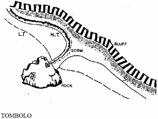
Tombolo
A causeway-like accretion spit connecting an offshore rock or island with the main shore.
Truck Maneuvering Area
An area of a site used by trucks for turning and backing or for access to loading/unloading areas.
15.7 Definitions: U to Z
Upland
The area above and landward of the ordinary high water mark.
Use or Use Activity
The purpose or activity for which the land, or building thereon, is designed, arranged or intended, or for which it is occupied or maintained and shall include any manner of performance or operation of such activity with respect to the provision of this title. The definition of "use" also includes the definition of "development."
Utility
A service or facility that produces, transmits, stores, processes, or disposes of electrical power, gas, water, sewage, communications, oil, and the like Utilities have been categorized in this master program as primary, accessory, and personal wireless facilities:
a) Primary utilities are services and facilities that produce, transmit, carry, store, process or dispose of power, gas, water, sewage, communications (excepting wireless facilities, see below), oil and the like. For example: sewage treatment plants and outfalls, public high-tension utility lines, power generating or transfer stations, gas distribution lines and storage facilities.
b) Accessory utilities are small-scale distribution services directly serving a permitted shoreline use. For example, power, telephone, cable, communication antennas, water, sewer lines, including stormwater systems.
c) Personal wireless facilities meaning any unstaffed facility for the transmission and/or reception of personal wireless services. This can consist of an equipment shelter or cabinet, a support structure or existing structure used to achieve the necessary elevation, and the antenna or antenna array.
Variance
A means of granting relief from specific bulk, dimensional or performance standards set forth in the applicable master program to a particular piece of property, which property, because of special circumstances is deprived of privileges commonly enjoyed by other properties in the same vicinity and environmental designation, and not a means to vary from the permitted uses of a shoreline. Reasonable use exceptions authorized by Chapter 19.05, in shorelines of the state also require approval of a shorelines variance.
Vegetation Removal
The removal or alteration of trees, shrubs, and/or ground cover by clearing, grading, cutting, burning, chemical means, or other activity that causes significant ecological impacts to functions provided by such vegetation. The removal of invasive or noxious weeds does not constitute significant vegetation removal. Tree pruning, not including tree topping, where it does not affect ecological functions, does not constitute significant vegetation removal.
Vegetation Stabilization
Planting of water-loving land vegetation upon shoreline banks, slopes, or berms to retain soil and retard erosion from surface run-off; planting of aquatic vegetation offshore to reduce wave action and retain bottom materials; and utilizing temporary structures or netting to enable plants to establish in unstable areas.
Vessel
Ship, boat, barge, or any other floating craft that is designed and used for navigation and does not interfere with the normal public use of the water.
Waste Disposal
Refuse composed of garbage, rubbish, ashes, dead animals, demolition wastes, automobile parts, and similar material.
Water-dependent Use
A use or a portion of a use, which, as its primary characteristic, cannot exist in any other location than on the water because it is dependent on the water by the intrinsic nature of its operations. Examples of a water-dependent uses include marinas, docks that support marinas, on- the-water recreational programs or small vessels that require in-water moorage, hand-launch or small boat launch sites, ferry and passenger ship terminals, ship or boat building areas, associated haul out facilities and dry docking, float plane facilities and sewer facilities.
Activities and development undertaken for the purpose of restoring ecological functions and values, or enhancing shoreline habitat are also considered water-dependent under this Master Program.
Water-enjoyment Use
A shoreline recreational use such as a park, pier, or other use that facilitates public access to the shoreline as a primary character of the use; or, a use that provides for passive/active recreational use or aesthetic enjoyment of the shoreline for a substantial number of people as a general character of the use and which, through location, design and operation assure the public’s ability to enjoy the physical and/or aesthetic qualities of the shoreline.
In order to qualify as a water-enjoyment use, the use must be open to the public and most if not all of the shoreline oriented space within the project must be devoted to the specific aspects of the use that foster shoreline enjoyment.
Water-enjoyment uses may include, but are not limited to, shoreline parks, public access piers or other improvements (e.g., walkways or boardwalks) facilitating public access to the shorelines of the state or that foster the public’s awareness and understanding of the shorelines of the state (e.g., shoreline or maritime-related museums, and scientific/ecological reserves).
Other uses, including mixed-use developments, may qualify as water- enjoyment uses if they include a mix of more than one of the general water-enjoyment uses designed to take advantage of a waterfront location, protect views of the water, enhance pedestrian traffic, and display and sell merchandise oriented to marine uses or other office and research functions contributing to marine activities. Examples may include those uses listed in the following table:
|
WATER-ENJOYMENT USES |
|---|
|
Ecological and Scientific Reserves |
|
Waterfront Parks |
|
Beaches for Public Use |
|
Aquariums Available to the Public |
|
Museums - Marine Oriented or Natural History |
|
Museums |
|
Restaurants |
|
Retail businesses housed in mixed use projects designed to take advantage of a waterfront location, protect views of the water and enhance pedestrian traffic, and which display and sell merchandise oriented to marine uses, including but not limited to: a. Fishing tackle b. Marine maps, books, magazines, catalogs c. Marine oriented provisions and clothing |
Water-oriented Use
A use or a portion of a use which is either a water-dependent, water- related, or water-enjoyment use, or any combination thereof. All uses which do not meet the definition of water-dependent, water-related, or water-enjoyment are classified as non-water-oriented uses.
Water-related Use
A use or portion of a use that is not intrinsically dependent on a waterfront location, but whose operation cannot occur economically without a shoreline location. Water-related uses contribute to the marine trades, maritime educational uses or maritime heritage uses or activities of a particular shoreline designation because of the following:
a. A functional requirement for a waterfront location, such as the arrival or shipment of materials by water (e.g., fish processors), or the ability to work on boats that are moored in a marina (e.g., sail lofts, riggers, boat repair) or;
b. The use provides a necessary service supportive of the water-dependent, water-related commercial activities and the proximity of the use to its customers and marine trades businesses makes its services less expensive and more convenient. Examples include marine chandleries or marine hardware stores, boat shops, marine electrical services, marine metal work or fabrication, or manufacturers of boat parts or supplies that are necessary for a viable marine trades economy; or
c. The use provides marine-related services necessary to serve in- water marinas and on-land boatyards that provide a cluster of marine-related businesses that derive an economic benefit from close proximity to one another. Examples include boat dealers and brokers, marine surveyors and marine architects, moorage offices, shower and laundromat facilities for moorage guests, and specialized professional services to support the marine trades; or
d. The use provides maritime educational or maritime heritage activities that strengthen the city’s marine trades businesses by providing a cluster of activities that support water-dependent uses, water-related uses and marine-related services. Examples include yacht or sail club facilities, diving shops with classes and/or rentals, recreational services that promote on-the-water activities (e.g., kayak rentals) and interpretive and educational facilities that provide demonstration areas or classrooms for marine trades or marine-related ecology or educational workshops, seminars or classes (e.g., vocational boat schools or maritime educational centers).
Watershed Restoration Plan
A plan, developed or sponsored by the Department of Fish and Wildlife, the Department of Ecology, the Department of Natural Resources, the Department of Transportation, a federally recognized Indian tribe acting within and pursuant to its authority, a city, a county, or a conservation district that provides a general program and implementation measures or actions for the preservation, restoration, re-creation, or enhancement of the natural resources, character, and ecology of a stream, stream segment, drainage area, or watershed for which agency and public review has been conducted pursuant to chapter 43.21C RCW, the State Environmental Policy Act.
Wetlands or Wetland Areas
Areas that are inundated or saturated by surface or ground water at a frequency and duration sufficient to support, and that under normal circumstances do support, a prevalence of vegetation typically adapted for life in saturated soil conditions. Wetlands generally include swamps, marshes, bogs, and similar areas. Wetlands do not include those artificial wetlands intentionally created from nonwetland sites, including, but not limited to, irrigation and drainage ditches, grass- lined swales, canals, detention facilities, wastewater treatment facilities, farm ponds, and landscape amenities, or those wetlands created after July 1, 1990, that were unintentionally created as a result of the construction of a road, street, or highway. Wetlands may include those artificial wetlands intentionally created from nonwetland areas to mitigate the conversion of wetlands if permitted by the City (RCW 36.70A.030(20)).
Wireless Facilities – See “Utility”