Appendix 20D-2 Critical Areas Reporting Requirements
I. General Information
II. Fish and Wildlife Habitat Conservation Areas Reporting Requirements
III. Wetland Reporting Requirements
IV. Frequently Flooded Areas Reporting Requirements
V. Geologically Hazardous Areas Reporting Requirements
VI. Critical Aquifer Recharges Areas (Wellhead Protection) Reporting Requirements
The following information is required to be submitted for sites containing critical areas.
I. General Information (required for all critical areas).
A. Name of proposal as shown on City applications.
B. Name of applicant as shown on City applications.
C. Name of organization and individual providing this information.
D. List any technical expertise/special qualifications of person providing this information.
E. Date the information was prepared.
F. Location of the proposed activity (street address and tax parcel number), including a vicinity map.
G. Clearly identify the development proposal being addressed; including City file number and key project drawing references (originator of drawings, originator’s reference number if shown on the drawings, sheet numbers, revision numbers and dates for each sheet, and include reduced copies of key drawings in the report).
H. Give a succinct but inclusive description of the existing site, including acreage and current and past uses on the property.
I. A copy of an aerial photo with overlays displaying site boundaries and critical areas.
J. A single map showing all critical areas at one unch equals 20 feet scale, depicting:
1. Identified critical areas and required buffers;
2. Limits of any areas to be disturbed;
3. Site boundary property lines and roads;
4. Rights-of-way and easements;
5. Existing physical improvements (buildings, fences, impervious surfaces, utilities, etc.);
6. Contours at two-foot intervals;
7. All natural and manmade features within the maximum buffer area of any critical area on or near the site (in no case less than a minimum 50 feet from the site).
K. A statement specifying the accuracy of the report and key project specific assumptions made and relied upon. List recommendations, if any, for further reporting regarding critical areas related to the proposed project as the project proceeds.
L. Provide a bibliography of published information referenced, including maps and best available science materials.
For sites with mitigation, also provide the following information identified in M through Q below. (Information in this section is to be provided only if there are critical areas within or in the vicinity of the site that will be impacted by the proposed project.)
M. A summary description of reasonable efforts made to apply mitigation sequencing pursuant to RCDG 20D.140.10-110, Mitigation Standards, Criteria and Plan Requirements, to avoid, minimize, and mitigate impacts to critical areas.
N. Plans for adequate mitigation, as needed, to offset any impacts, including, but not limited to:
1. The impacts to on-site and affected off-site critical areas; and
2. The impacts of any proposed alteration of a critical area or buffer on the development proposal, other properties, and the environment.
O. A listing of applicable performance standards and a summary of how each applicable performance standard was addressed. (See RCDG 20D.140.10-120, Performance Standards for Mitigation Planning).
P. A discussion of ongoing management practices that will protect the critical area after the project site has been developed, including proposed monitoring and maintenance programs.
Q. Additional information may be required. The Technical Committee may require additional information to be included in the critical areas report when deemed necessary to the review of the proposed activity.
II. Fish and Wildlife Habitat Conservation Areas Reporting Requirements (includes streams).
A fish and wildlife habitat conservation areas report shall be prepared by a qualified professional who is a biologist with experience preparing reports for the relevant type of habitat.
Wildlife Report Requirements (in addition to the General Information listed in Section I above).
A. A wildlife report must be submitted to the City for review. The purpose of the report is to determine the extent, function and value of wildlife habitat on any site where regulated activities are proposed. The report will also be used by the City to determine the sensitivity and appropriate classification of the habitat, appropriate wildlife management requirements, and potential impacts of proposed activities. The information required by this report should be coordinated with the study and reporting requirements for any other critical areas located on the site.
B. The report shall include the following information:
1. A map drawn at an engineering scale of one inch equals 20 feet of vegetative cover types, reflecting the general boundaries of different plant communities on the site.
2. A description of the species typically associated with the cover types, including an identification of any species of concern, priority species, and species of local importance that might be expected to be found.
3. The results of searches of DNR’s Natural Heritage and Non-Game Data System databases.
4. The result of searches of the Washington Department of Wildlife Priority Habitat and Species database.
5. Habitat Assessment. A habitat assessment is an investigation of the project area to evaluate the presence or absence of a potential (listed) fish or wildlife species of concern or habitat. A fish and wildlife habitat conservation area report shall contain a written assessment of habitats, including the following site and proposal related information at a minimum:
a. General site conditions including topography, waterbodies, and wetlands.
b. Detailed description of vegetation on and adjacent to the project area.
c. Identification of any areas that have previously been disturbed or degraded by human activity or natural processes.
d. The layers, diversity and variety of habitat found on the site.
e. Identification of edges between habitat types and any species commonly associated with that habitat.
f. The location of any migration or movement corridors.
g. A narrative summary of existing habitat functions and values.
h. Identification of any species of local importance, priority species, threatened, sensitive, or candidate species that have a primary association with the habitat on or adjacent to the project area, and assessment of potential impacts to the use of the site by the species.
i. A discussion of any local, state, or federal management recommendations, including Washington Department of Fish and Wildlife habitat management recommendations, that have been developed for species or habitats located on or adjacent to the project area.
j. Identification of any core preservation areas that are on or adjacent to the site. See RCDG 20D.140.20-010(1) for areas considered core preservation areas. Map and describe these areas.
k. Identification of any quality habitat areas that are on the site. See RCDG 20D.140.20-010(3) for areas considered quality habitat areas. Map and describe these areas. This shall include an analysis of size, community diversity, interspersion, continuity, forest vegetation layers, forest age, and invasive plants.
l. A summary of proposed habitat alterations and impacts and proposed habitat management program. Potential impacts may include but are not limited to clearing of vegetation, fragmentation of wildlife habitat, expected decreases in species diversity or quantity, changes in water quality, increases in human intrusion, and impacts on wetlands or water resources.
m. A discussion of measures, including avoidance, minimization, and mitigation, proposed to preserve the existing habitats and restore any habitat that was degraded prior to the current proposed land use activity and to be constructed in accordance with RCDG 20D.140.10-110, Mitigation Standards, Criteria, and Plan Requirements.
6. Habitat Unit Assessment Forms. One completed form is required for each habitat unit identified on site.
7. Additional Information. When appropriate due to the type of habitat or species present, or the project area conditions, the Technical Committee may also required the habitat management plan to include:
a. An evaluation by an independent qualified professional regarding the applicant’s analysis and the effectiveness of any proposed mitigating measures or programs to include any recommendations as appropriate.
b. A request for consultation with the Washington Department of Fish and Wildlife or the local Native American Indian tribe.
c. Detailed surface and subsurface hydrologic features both on and adjacent to the site.
Stream Reconnaissance Report Requirements (in addition to the General Information listed in Section I above).
A stream reconnaissance report shall be prepared by a qualified stream biologist or stream ecologist.
A. A stream reconnaissance report must be submitted to the City for review. The purpose of the report is to determine the physical and biological characteristics and functions and values of streams on any site where regulated activities are proposed. The report will also be used by the City to establish appropriate buffer requirements. The information required for this report should be coordinated with the study and reporting requirements established for any other critical areas located on the site.
B. The ordinary high water mark shall be flagged in the field by a qualified consultant. Field flagging must be distinguishable from other survey flagging on the site. The field flagging must be accompanied by a stream reconnaissance report.
C. The report shall include the following information:
1. Streams Map. Stream ordinary high water marks (OHWM) shall be located on a site map with an engineering scale of one inch equals 20 feet. The map must show:
a. Surveyed locations of all stream OHWMs on the property;
b. Hydrologic mapping showing patterns of water movement into, through, and out of the site area.
2. Stream Reconnaissance Report. A written stream reconnaissance report which includes the following information:
a. A written stream assessment. This assessment shall describe specific descriptions of streams, including stream classification, gradient and flow characteristics, stream bed condition, stream bank and slope stability, presence of fish or habitat for fish, presence of obstruction to fish movement, general water quality, stream bank vegetation, and stream buffer requirements.
b. A written characterization of the riparian corridor. This characterization shall include analysis of the stream buffer to provide the following key functions: shade and temperature regulation, flood conveyance, water quality protection and pollutant removal, nutrient cycling, sediment transport, bank stabilization, woody debris recruitment, wildlife habitat, and microclimate control.
c. A written summary of existing stream value for fisheries habitat, including special consideration for anadromous fisheries. This shall include a discussion on the stream’s potential for salmonid and non-salmonid fish use. Parameters to be analyzed include, but are not limited to, distance of bank full width, channel gradient, size of contributing upstream areas, and fish passage obstructions, if any.
d. A written discussion of measures including avoidance, minimization, and mitigation to preserve the existing riparian corridor and restore areas that were degraded prior to the current proposed land use activity. This shall include a summary of proposed stream and buffer alterations, impacts, and the need for the alterations as proposed. Potential impacts may include but are not limited to vegetation removal, stream bed and stream bank alterations, alteration of fisheries habitat, changes in water quality, and increases in human intrusion. If alteration of a stream is proposed, a stream mitigation plan is required according to the standards of RCDG 20D.140.20-040, Alteration or Riparian Stream Corridors and 20D.140.20-060, Riparian Stream Corridor Performance Standards.
3. Stream summary sheet.
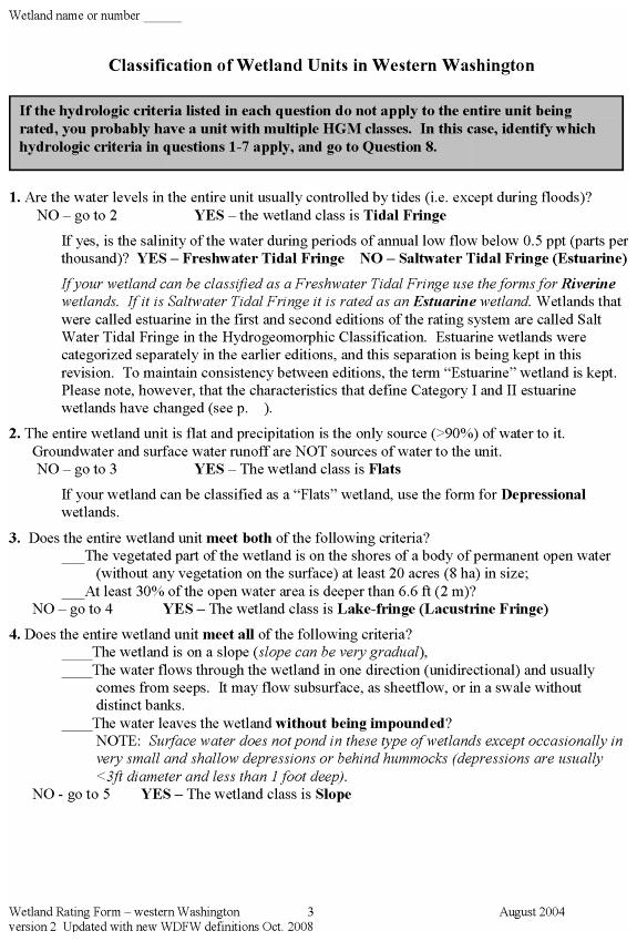
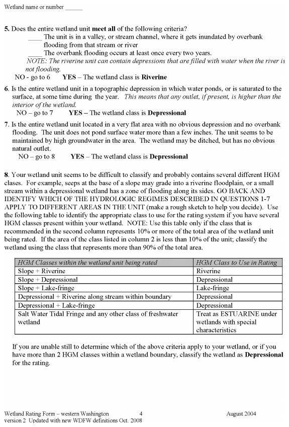
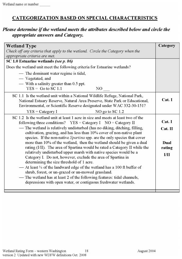
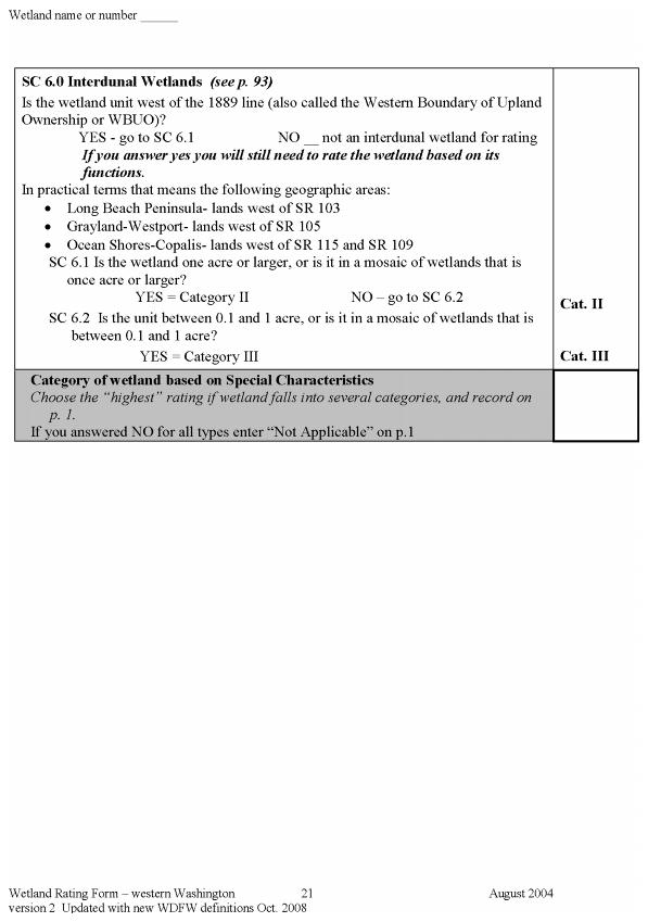
III. Wetland Reporting Requirements (In addition to the General Information listed in Section I above).
A wetland report shall be prepared by a qualified professional who is a certified wetland scientist or a wetland biologist.
A. A wetland report must be submitted to the City for review. The purpose of the report is to determine the extent, characteristics, functions, and values of any wetlands located on a site where regulated activities are proposed. The report will also be used by the City to determine the appropriate wetland rating and to establish appropriate buffer requirements. The information required by this report should be coordinated with the study and reporting requirements for any other critical areas located on the site.
B. Wetland boundaries must be staked and flagged in the field by a qualified consultant employing the Washington State Wetlands Identification and Delineation Manual. Field flagging must be distinguishable from other survey flagging on the site. The field flagging must be accompanied by a wetland delineation report. Transects shall be required for all wetland identifications, regardless of size. Note that wetland determinations made during the late summer months (July – Sept.) and early fall (Sept. – Oct.) may lack a wetland water regime due to low precipitation. A “wet weather” evaluation may be required.
C. The report shall include the following information:
1. Wetland Map. Wetlands shall be located on a site map with an engineering scale of one inch equals 20 feet. The map must show:
a. Delineated wetland boundary and required buffers.
b. Hydrologic mapping showing patterns of water movement into, through, and out of the site area.
c. Location of all test holes and vegetation sample sites, numbered to correspond with flagging in the field and field data sheets.
2. Site designated on a National Wetland Inventory Map (U.S. Fish and Wildlife Service) and a City of Redmond Wetland Inventory Map.
3. Wetland Delineation Report. A written wetland delineation report which includes the following information:
a. Delineation methodology, with special emphasis on whether the approach used was routine, intermediate, or comprehensive, as described in the Wetland Manual. This shall include an explanation of how the wetland boundary was determined. The explanation shall identify assumptions made and provide clarification of “close calls.”
b. A written wetland assessment. This assessment shall describe specific descriptions of wetlands, including wetland category, classification using the USFWS (Cowardin) Method, vegetative, faunal and hydrologic characterization, soil and substrate conditions, wetland acreage, and required buffers.
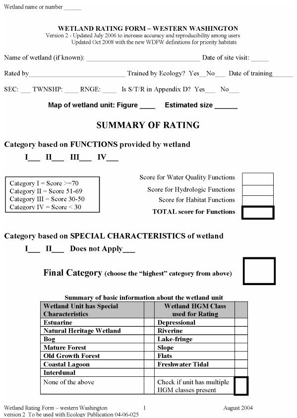
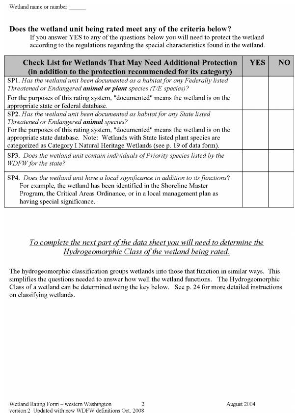
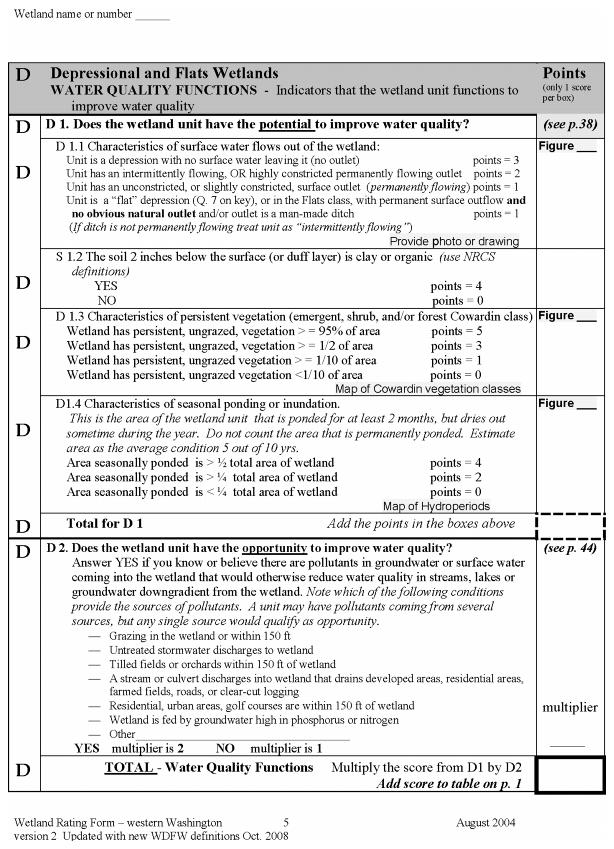
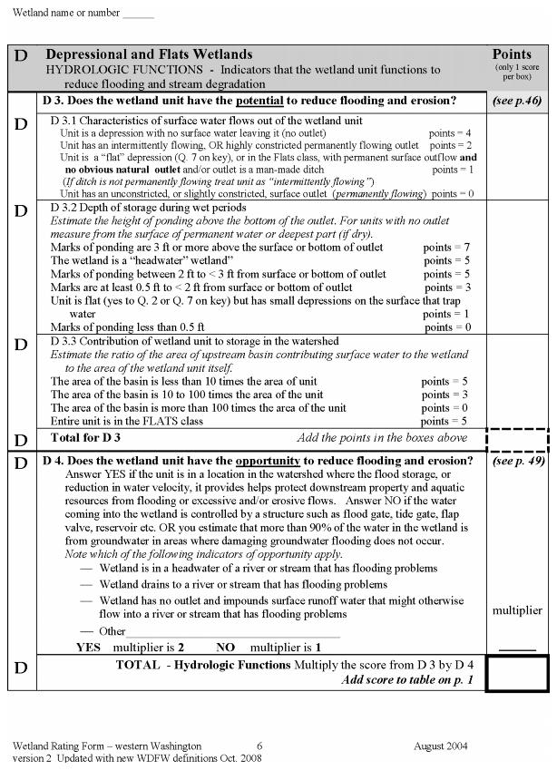
c. A written wetland characterization and wetland functions assessment. Wetland characterizations shall use the Wetland Rating System for Western Washington. This characterization identifies the wetland category. The wetland category and “score” shall be part of the description for each wetland. This characterization shall include an analysis of the wetland’s ability to provide the following key functions: provide wildlife, plant, and fisheries habitat; moderate runoff volume and flow rates; reduce sediment, chemical nutrient, and toxic pollutants; provide shading to maintain desirable water temperatures; reduce erosion; and reduce groundwater and surface water pollution. A wetland functions assessment shall be completed for each wetland to establish a baseline that provides a semi-qualitative description for each wetland. A functions assessment must evaluate existing conditions and conditions after development without mitigation. Those functions assessments found acceptable by the Department of Ecology and best available science include the Washington Function Assessment Method and the Linear Method.
d. A summary of proposed wetland and buffer alterations, impacts, and the need for the alterations as proposed. This shall include a mitigation sequencing analysis. Potential impacts may include but are not limited to loss of flood storage potential, loss of wildlife habitat, expected decreases in species diversity or quantity, changes in water quality, increases in human intrusion, and impacts on associated wetland or water resources. If wetland impacts are proposed, a wetland mitigation plan is required according to the standards of RCDG 20D.140.10-120, Performance Standards for Mitigation Planning.
4. Field data sheets from the Wetland Manual, numbered to correspond with sample site locations as staked and flagged in the field. This includes Data Form 1: Routine Wetland Determination as identified in Appendix B of the Washington State Wetlands Identification and Delineation Manual.
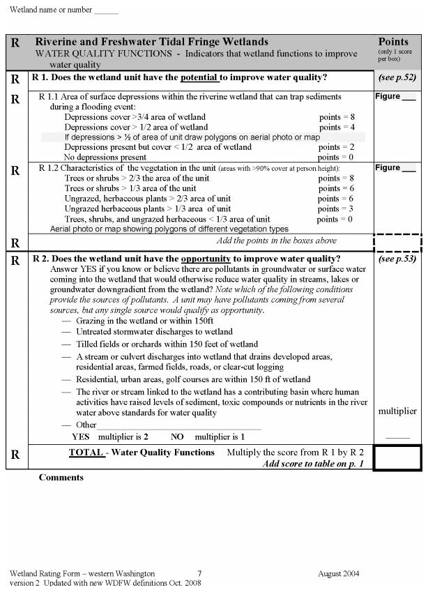
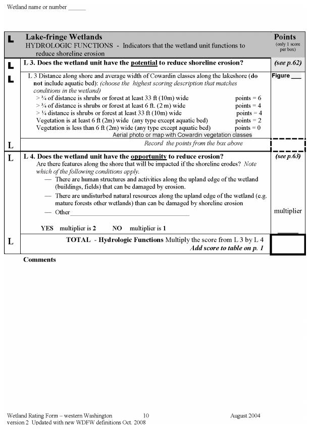
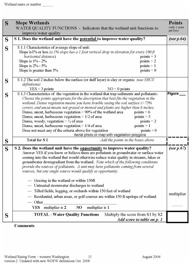
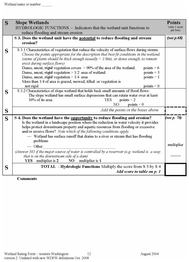
5. Wetland rating forms for each wetland as identified in the Washington State Wetland Rating System for Western Washington.
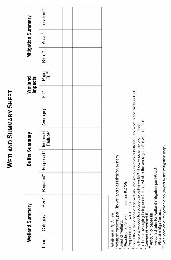
6. Wetland summary sheet.
IV. Frequently Flooded Areas Reporting Requirements (In addition to the General Information listed in Section I above).
A frequently flooded area report shall be prepared by a qualified professional who is a hydrologist, or engineer, who is licensed in the State of Washington with experience in preparing flood hazard assessments.
A. A frequently flooded area report must be submitted to the City for review for Shorelines of the State (and other watercourses if specifically requested in the review process). The purpose of this report is to ensure the development complies with City of Redmond and Federal Emergency Management Agency (FEMA) requirements and guidelines. The report must include the following site and proposed related information at a minimum:
1. Floodplain Map. Floodplains shall be located on a site map with an engineering scale of one inch equals 20 feet. The map must show the following:
a. The location of the FEMA 100-year floodplain, the “Built Out” 100-year floodplain, the FEMA floodway, and the zero-rise floodway.
b. All proposed development within the Built Out 100-year floodplain.
c. Elevation of the lowest floor (including basements and excavated crawl spaces) of all structures.
d. Location of and proposed grading for compensatory floodplain storage, if required per RCDG 20D.140.40-030(2)(a).
2. Flood Hazard Summary. A written flood hazard summary shall be provided that includes the following:
a. Descriptions and engineering calculations that support the locations of the 100-year FEMA and zero-rise floodplains within the site (see guidelines below).
b. Descriptions and engineering calculations that support the locations of the 100-year FEMA and zero-rise floodways within the site (see guidelines below).
c. A statement to verify that fill and structures will not be located within floodways.
d. Verification that any proposed changes (including utilities, plantings, walkways, etc.) within the floodways will not affect the hydraulic capacities of the floodways. Supporting calculations will be required if changes are proposed in the floodways.
e. Verification that hydraulically equivalent compensating storage is provided if such storage is required for the site per RCDG 20D.140.40-030(2)(a).
B. Locating the Edge of the Floodplain for a Site. This section provides a method to locate the edge of the floodplain for a site so as to conform to detailed topographic mapping at a site plan scale. The basic approach is to use elevations of the water surface at flood stage and project the elevations along cross-sections until they intersect with the site scale topographic map.
The resulting floodplain defined for the site must be checked by engineering calculations to verify adequate conveyance with no increase in the flood stage water surface elevations for the floodplain. Include the following for both the FEMA and zero-rise floodplains:
1. Appropriate data from current floodplain studies and maps including flood profiles, selected cross-section locations, flood elevations for each cross-section, and base flood discharge(s).
2. Actual field topography with appropriate contours for the entire floodplain within the site plus the floodplain on the opposite side of the stream plus the floodplain upstream and downstream of the site for at least 100 feet.
3. Cross-section locations on the site topography map showing intersections of the flood elevations with the topographic elevations. These intersection points are then connected, using topographic information, to outline the floodplain.
4. Verification, by hydraulic calculations, that the base flood discharge can be accommodated within the defined floodplain and within the flood elevations. (Contact Development Services for level of calculations required.)
5. Proposed topographic adjustments, based on site-specific situations, to provide adequate hydraulic capacity if hydraulic calculations do not verify such capacity which are acceptable to the Technical Committee.
C. Locating the Current Floodway Limits for a Site. This section provides a way to apply and adjust the floodway maps for a site. The adopted floodway maps are official documents. Changes to the FEMA map generally require FEMA approval. Both FEMA and the City recognize, however, that more detailed site-scale topography and the difficulties in scaling the floodway map dictate that map refinements must frequently be done when working at the site plan scale. Include the following for both the FEMA and zero-rise floodways:
1. An appropriate section of the current floodplain maps enlarged to site plan scale. The section of the map needs to include the entire site, the entire floodplain on the opposite side of the stream, and the floodplain 100 feet upstream and downstream of the site.
2. Appropriate data from current floodway studies including flood profiles, selected cross-section locations, flood elevations for each cross-section, and base flood discharges.
3. Actual field topography with appropriate contours for the entire floodplain within the site plus the floodplain on the opposite side of the stream plus the floodplain upstream and downstream of the site for at least 100 feet. Show cross-section locations on this topographic map.
4. Location of the floodway limits from the enlarged floodway map on the topographic map.
5. Adjustments to the floodway location as required to reconcile the site topography and the flood profiles. Clearly identify all proposed adjustments.
6. Verification that the floodway study discharge can be accommodated within the floodway (including adjustments approved by the Technical Committee) and within regulatory water surface elevations and velocities.
V. Geologically Hazardous Areas Reporting Requirements (in addition to the General Information listed in Section I above).
A geologically hazardous areas report shall be prepared by a geotechnical engineer or geologist, licensed in the State of Washington, with experience analyzing geologic, hydrologic, and groundwater flow systems; or by a geologist who earns his or her livelihood from the field of geology and/or geotechnical analysis, with experience analyzing geologic, hydrologic and groundwater flow systems, who has experience preparing reports for the relevant type of hazard.
A. A geologically hazardous area report must be submitted to the City. The purpose of this report is to evaluate the actual presence of geologic conditions giving rise to geologic hazards; determine the appropriate class of hazard, according to the classification of potential hazards contained in these regulations; evaluate the safety and appropriateness of proposed activities; and recommend appropriate construction practices, monitoring programs and other mitigation measures required to ensure achievement of the purpose and intent of these regulations. The information required by this report should be coordinated with the study and reporting requirements for any other critical areas located on the site.
B. The approach of the City of Redmond critical area regulations is to require a level of study and analysis commensurate with potential risks associated with geologic hazards on particular sites and for particular proposals. Depending on the particular geologic hazard, geologic, hydrologic and/or topographic studies may be required. At a minimum, all applicants shall review the history of the site and conduct a surface reconnaissance.
C. Geologically Hazardous Area Report. The geologically hazardous area report shall include the following information:
1. Geologically Hazardous Areas Map. Geologic hazards shall be located on a site map with an engineering scale of one inch equals 20 feet. The map must show the surveyed locations of all geologic hazards and their required buffers/setbacks. In addition, the map must show topography at two-foot intervals.
2. A written geologically hazardous area report which includes the following information:
a. A written geologic hazards characterization. This characterization shall describe specific descriptions of geologic hazards present on site, including topography; a characterization of soils, geology, and drainage; a characterization of groundwater conditions including the presence of any public or private wells within one quarter mile of the site; and groundwater elevation, gradient and direction data, including depth and duration of seasonally high water table if any proposed grading, borings, pilings or excavation work may extend to groundwater depth; identification of any areas that have previously been disturbed or degraded by human activity or natural processes; and a site history.
b. A written analysis of proposed clearing, grading and construction activities, including construction scheduling; potential direct and indirect, on-site and off-site impacts from development, including dewatering activities. The analysis shall include identification of proposed mitigation measures, including any special construction techniques, monitoring or inspection program, erosion or sedimentation programs (during and after construction), and surface water management and protection controls.
3. Critical Landslide Hazard Areas (Steep Slopes). In addition to the geologically hazardous area report required above, the following tasks and information are required for critical landslide hazard areas.
a. Review site history and available information.
b. Conduct a surface reconnaissance of the site and adjacent areas.
c. Conduct subsurface exploration suitable to site and proposal to assess geohydrologic conditions.
d. Conduct detailed slope stability analysis.
e. Recommend detailed surface water management controls during construction and operation.
f. Establish recommendations for site monitoring and inspection during construction.
g. Recommended minimum steep slope buffer distance(s). In no case, shall the setback be less than that required by RCDG 20D.140.60-020.
4. Critical Erosion Hazard Areas. In addition to the geologically hazardous area report required above, the following tasks and information are required for critical erosion hazard areas:
a. Review site history and available information.
b. Conduct a surface reconnaissance of the site and adjacent areas.
c. Identify surface water management, erosion and sediment controls appropriate to the site and proposal.
5. Seismic Hazard Areas. In addition to the geologically hazardous area report required above, the following tasks and information are required for seismic hazard areas:
a. For one- and two-story single-family structures, conduct an evaluation of site response and liquefaction potential based on the performance of similar structures under similar foundation conditions.
b. For all other proposals, conduct an evaluation of site response and liquefaction potential including sufficient subsurface exploration to provide a site coefficient (S) for use in the static lateral force procedure described in the International Building Code.
VI. Critical Aquifer Recharges Areas (Wellhead Protection) Reporting Requirements (in addition to the General Information listed in Section I above and the general information listed in Section V above).
A critical aquifer recharge areas report shall be prepared by a qualified professional who is a hydrogeologist, geologist, or engineer, who is licensed in the State of Washington and has experience in preparing hydrogeologic assessments.
A. A critical aquifer recharge area report must be submitted to the City. The purpose of the report is to evaluate the actual presence of geologic conditions giving rise to the critical aquifer recharge area; determine the appropriate wellhead protection zone; evaluate the safety and appropriateness of proposed activities; and recommend appropriate construction practices, monitoring programs and other mitigation measures required to ensure achievement of the purpose and intent of these regulations. The information required by this report should be coordinated with the study and reporting requirements for any other critical areas located on the site.
B. The approach of the City of Redmond critical area regulations is to require a level of study and analysis commensurate with potential risks to wellhead protection areas associated with particular sites and particular proposals. Geologic, hydrologic and/or topographic studies may be required. At a minimum, all applicants shall review the history of the site and conduct a surface reconnaissance.
C. Hydrologic Assessment Required. For all proposed activities to be located in a critical aquifer recharge area, a critical aquifer recharge area report shall contain a level one hydrological assessment. A level two hydrogeologic assessment shall be required for any of the following proposed activities:
1. Activities that result in 5,000 square feet or more impervious site area.
2. Activities that divert, alter, or reduce the flow of surface or groundwaters, including dewatering or otherwise reduce the recharging of the aquifer.
3. The storage, handling, treatment, use, production, recycling or disposal of deleterious substances or hazardous materials, other than household chemicals used according to the directions specified on the packaging for domestic applications.
4. The use of injection wells, including on-site septic systems, except those domestic septic systems releasing less than 14,500 gallons of effluent per day and that are limited to a maximum density of one system per one acre.
5. Any other activity determined by the Committee likely to have an adverse impact on groundwater quality or quantity, or on the recharge of the aquifer.
D. Written Level One Hydrogeologic Assessment. A level one hydrogeologic assessment shall include the following site and proposal related information at a minimum:
1. Available information regarding geologic and hydrogeologic characteristics of the site including the surface location of all critical aquifer recharge areas located on site or immediately adjacent to the site, and permeability of the unsaturated zone.
2. Groundwater depth, flow direction and gradient based on available information.
3. Currently available data on wells and springs within 1,300 feet of the project area.
4. Location of other critical areas, including surface waters, within 1,300 feet of the project site.
5. Available historic water quality data for the area to be affected by the proposed activity.
6. Best management practices proposed to be utilized.
E. Written Level Two Hydrogeologic Assessment. A level two hydrogeologic assessment shall include the following site and proposal related information at a minimum, in addition to the requirements for a level one hydrogeological assessment:
1. Historic water quality data for the area to be affected by the proposed activity compiled for at least the previous five year period.
2. Groundwater monitoring plan provisions.
3. Discussion of the effects of the proposed project on the groundwater quality and quantity, including:
a. Predictive evaluation of groundwater withdrawal effects on nearby wells and surface water features.
b. Predictive evaluation of contaminant transport based on potential releases to groundwater.
4. Identification of the type and quantities of any deleterious substances or hazardous materials that will be stored, handled, treated, used, produced, recycled, or disposed of on the site.
5. Proposed methods of storing any of the above substances, including containment methods.
6. Proposed plan for implementing protection standards during construction.
7. A spill plan that identifies equipment and/or structures that could fail, resulting in an impact. Spill plans shall include provisions for regular inspection, repair, and replacement of structures and equipment that could fail.
Stream and Wetland Mitiigation Plans
I. Where it is determined by the City that compensatory mitigation is required or appropriate, a mitigation plan shall be prepared. The purpose of the plan is to prescribe mitigation to compensate for impacts to the affected wetland or stream functions, values and acreage as a result of the proposed action. This plan shall consider the chemical, physical, and biological impacts on the wetland or stream system using a recognized assessment or evaluation methodology and/or best available science.
II. Mitigation plans shall be prepared in three phases: a conceptual plan, a final plan, and an as-built plan. All mitigation plans shall be drawn at an engineering scale of one inch equals 20 feet.
A. Conceptual Plan. The applicant shall submit a conceptual mitigation plan, prepared by a qualified consultant, when filing for entitlement or plat approval. The plan must be of adequate detail to demonstrate that impacts can be mitigated such that they achieve no net loss of functions and values. The conceptual mitigation plan shall include:
1. General goals of the mitigation plan. These goals must improve existing conditions, demonstrate no net loss of functions and values will be achieved, and must be measurable.
2. A review of alternative actions that would avoid or lessen the impacts on the wetland/stream.
3. Demonstrate compliance with the Critical Areas Ordinance (Chapter 20D.140 RCDG) and BAS.
4. A review of literature or experience to date in restoring or creating the type of wetland/stream proposed.
5. Approximate site topography following construction.
6. Location of proposed wetland/stream impact area.
7. Location of proposed wetland/stream compensation area.
8. Location of required and proposed buffers.
9. General hydrologic patterns on the site prior to and following construction.
10. Nature of compensation, including wetland/stream or habitat types (in-kind and out-of-kind), general plant selection and justification, approximate project sequencing and schedule, and approximate size of the new critical area buffer.
11. A conceptual maintenance plan.
12. Conceptual monitoring and contingency plan consistent with RCDG 20D.140.10-150. The monitoring program shall be used to determine the success of the mitigation project and any necessary corrective actions. Monitoring programs must comply with the City’s guidelines set forth in RCDG 20D.140.10-150(3). Monitoring methods and components shall be consistent with RCDG 20D.140.10-150(3)(e).
B. Final Plan. The applicant shall submit a final mitigation plan prepared by a qualified consultant when filing for civil construction drawing review or building permit, whichever is applicable. The final civil drawings or building permit (as applicable) shall not be approved until the final mitigation plan and bonds have been approved and accepted by the City. Each detailed plan shall contain, at a minimum, the following components, and shall be consistent with applicable mitigation standards:
1. A clear statement of the objectives of the mitigation. The goals of the mitigation plan shall be stated in terms of the new wetland/stream functions and values compared to the functions and values of the original wetland/stream. The goals must achieve no net loss of wetland/streams functions and values and be measurable. Objectives shall include:
a. Qualitative and quantitative standards for success of the project, including hydrologic characteristics (water depths, water quality, hydroperiod/hydrocycle characteristics, flood storage capacity); vegetative characteristics (community types, species composition, density, and spacing); faunal characteristics; and final topographic elevations.
b. An ecological assessment of the wetland’s/stream’s functions and values and wetland/stream buffers that will be lost as a result of the activities, and of the replacement wetlands/streams and their associated buffers, including but not limited to the following:
i. Acreage of project.
ii. Existing functions and values.
iii. Sizes of wetlands/streams, wetland/stream buffers, and areas to be altered, created, restored, or enhanced.
iv. Vegetative characteristics, including community type, area coverage, species composition, and density.
v. Habitat type(s) to be enhanced, restored, or created.
vi. Dates for beginning and completion of mitigation project, and sequence of construction activities.
c. A statement of the location, elevation, and hydrology of the new site, including:
i. Relationship of the project to the watershed and existing water bodies.
ii. Topography of site using two-foot.
iii. Water level data, including depth and duration of seasonally high water table.
iv. Water flow patterns.
v. Grading, filling and excavation, including a description of imported soils and amended soils. Any clearing, grading, or filling of wetlands/streams and their buffers shall also be shown on the clearing and grading civil drawings.
vi. Irrigation requirements, if any.
vii. Water pollution mitigation measures during construction.
viii. Aerial coverage of planted areas to open water areas (if any open water is to be present).
ix. Required buffers per Chapter 20D.140 RCDG.
d. A planting plan, describing what will be planted where and when, including:
i. Soils and substrate characteristics, including soil amendments.
ii. Substrate stockpiling techniques.
iii. Planting instructions, including species, stock type and size, density or spacing of plants, and water and nutrient requirements. Fifty percent of the plants shall meet minimum size at installation requirements of the City’s landscape code, RCDG 20D.80.10-100(5).
iv. Temporary irrigation plan and details.
e. Discussion of site construction, including construction oversight, protection of critical areas, construction sequencing, and best management practices.
f. A monitoring and maintenance plan, consistent with applicable requirements of RCDG 20D.140.10-150.
i. Specify procedures for monitoring and site maintenance per RCDG 20D.140.10-150(3).
ii. Submittal of periodic monitoring reports to the Planning Department as required by RCDG 20D.140.10-150(3)(d).
g. A contingency plan, which addresses the potential need and responsibility to modify the mitigation program over time to achieve a functioning system that requires minimal maintenance, and is consistent with requirements of RCDG 20D.140.10-150.
h. A detailed budget for implementation of the mitigation plan, including installation, monitoring, maintenance and contingency phases for a minimum of five years.
i. A guarantee, in the form of a bond or other security device in a form and amount acceptable to the City, assuring that the work will be performed as planned and approved, consistent with the requirements of RCDG 20D.140.10-150. The amount of the guarantee shall be, in part, based upon subsection (h) above and shall be established for a minimum of five years per RCDG 20D.140.10-150(2).
C. As-Built Plan. Wetland/stream mitigation as-built plans shall be submitted to the City along with engineering as-built requirements. A copy of the mitigation as-builts shall be submitted to the Planning Department.
1. The as-built plan shall be an accurate depiction of the delineated wetland/stream, constructed mitigated wetland/stream (altered, enhanced, restored, or created), and required buffers.
2. The plan shall also include a table identifying the following information for each wetland or stream on site:
a. Area (sq. ft.) of undisturbed wetland/stream.
b. Area (sq. ft.) of mitigated wetland/stream.
c. Area (sq. ft.) and width (ft.) of buffer.