


4-3-030 RAINIER/GRADY JUNCTION OVERLAY:
A. PURPOSE:
The purpose of the Rainier/Grady Junction (“RGJ”) Overlay (“RGJ Overlay”) is to implement the Rainier/Grady Junction TOD Subarea Plan (“Subarea Plan”) and Planned Action EIS to reinforce the City’s planned concentration of pedestrian-oriented mixed-use development at intensities that support and are supported by multi-modal transportation options. The RGJ Overlay is intended to help revitalize a portion of the City Center Community Planning Area by creating incentives and opportunities for a mix of jobs and residences, maximizing the use of public transit, and providing a framework for future infrastructure and service decisions. The RGJ Overlay aims to leverage public and private investments to provide public benefits in the form of housing affordable to a wide range of income earners, the creation of public open spaces, increased pedestrian connectivity, quality urban design, and a unique sense of place.
The specific objectives of this Section are to:
1. Encourage people to walk, ride a bicycle or use transit by achieving a compact pattern of development that is more conducive to walking and bicycling;
2. Encourage the creation of housing affordable to a wide range of income earners;
3. Encourage the creation of public open spaces;
4. Revitalize a portion of the City Center Community Planning Area;
5. Allow for a mix of uses to create an environment that engages people at the pedestrian scale;
6. Provide a high level of amenities, design, and landscaping that create a comfortable environment for pedestrians, bicyclists, and other users;
7. Maintain an adequate level of parking and access for automobiles;
8. Create fine-grained detail in architectural and urban form that provides interest and complexity at the level of the pedestrian and bicyclist;
9. Encourage uses that allow round-the-clock activity;
10. Provide sufficient density of employees, residents, and recreational users to support transit;
11. Generate a relatively high percentage of trips serviceable by transit; and
12. Mitigate air and noise pollution on people living or working in new development close to I-405.
B. DEFINITIONS:
1. Planned Action Ordinance: Ordinance 6150, which established the Rainier Grady Way TOD Subarea Planned Action within the Rainier/Grady Way Subarea.
2. Rainier/Grady Junction TOD Subarea Plan: Adopted by Resolution 4454. Commonly referred to as “Subarea Plan” within this Section.
3. Planned Action EIS: The Rainier/Grady Junction TOD Subarea Planned Action Environmental Impact Statement (EIS) (comprised of both the Draft EIS and the Final EIS, Exhibit A to the Planned Action Ordinance) which provides mitigation measures found by the Planned Action Ordinance to adequately mitigate environmental impacts.
C. APPLICABILITY:
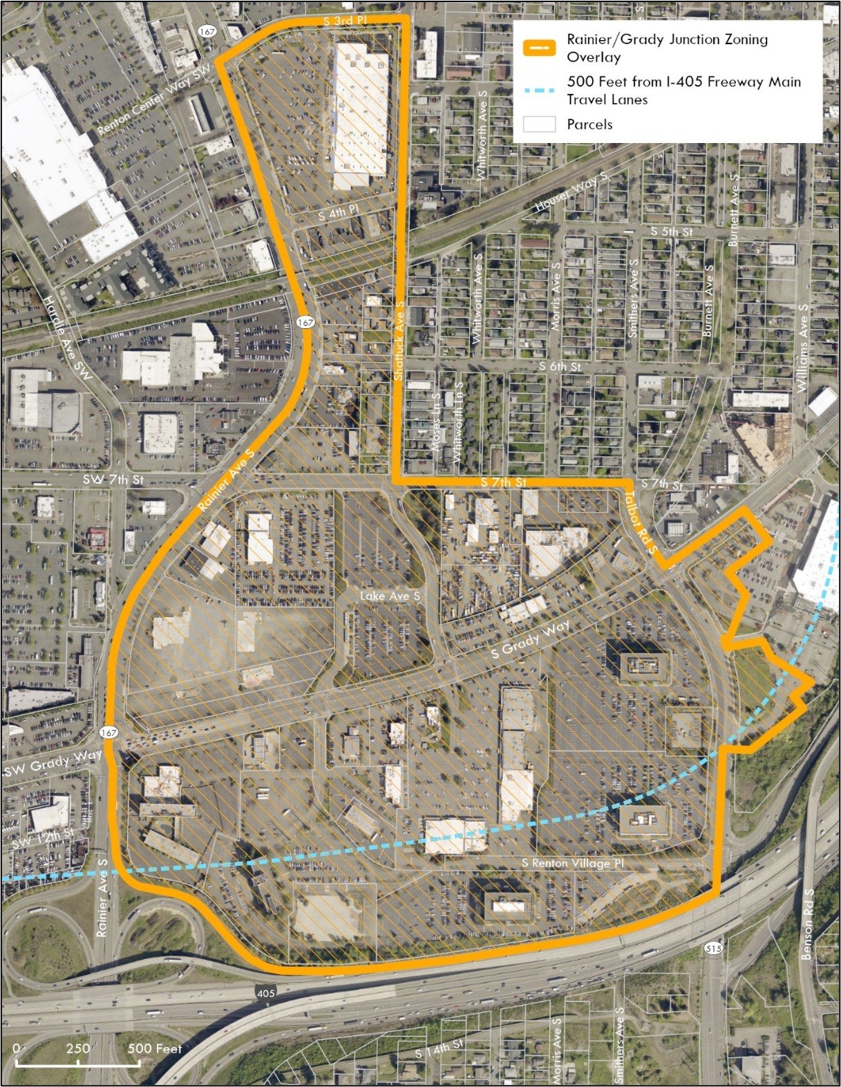
This Section shall apply to all use and development activities within the RGJ Overlay, as shown in the map below. Renton Municipal Code (“RMC”) provisions in Title IV, Development Regulations, as it exists and may be amended, contain zoning, regulations, standards, and guidelines governing site development of property City-wide, such as parking, landscaping, fencing, tree retention, and others. Such provisions shall apply within RGJ Overlay unless there is a conflict with the standards set forth by the RGJ Overlay, in which case the Administrator shall determine which standards apply.
This Section shall sunset, and as of that date is repealed, when the development allowed in Subsection III(D)(2)(a) of the Planned Action Ordinance is achieved, if the trip bank in Subsection III(D)(3) of the Planned Action Ordinance is achieved, or twenty (20) years after the adoption of the Planned Action Ordinance, whichever occurs first.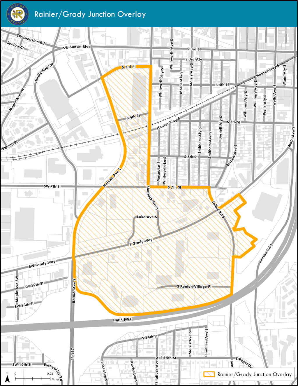
D. ADMINISTRATION:
1. Review Process: Applications subject to RGJ Overlay regulations shall be processed as a component of the governing land use process.
2. Environmental Review: Upon determination by the City’s SEPA Responsible Official that the proposal meets the criteria to qualify as a planned action pursuant to the Rainier/Grady Junction TOD Subarea Planned Action EIS, the application shall not require a SEPA threshold determination, preparation of an EIS, or be subject to further review pursuant to SEPA. Applications that do not qualify as a planned action shall be subject to RMC 4-9-070, Environmental Review Procedures.
a. A proposed project that would result in a significant change in the type or degree of impacts to any of the elements of the environment analyzed in the planned action EIS would not qualify as a planned action.
b. Should environmental conditions change significantly from those analyzed in the planned action EIS, the City’s SEPA Responsible Official may determine that the planned action designation is no longer applicable until supplemental environmental review is conducted.
c. The City may adopt and apply such other fees as may be deemed necessary and appropriate to mitigate impacts to other capital facilities in the RGJ Overlay and to accommodate planned growth.
3. Authority: The Administrator shall have the authority to administer this Section and approve with conditions or deny proposals based on the provisions of this Section when no other permit or approval requires Hearing Examiner review.
E. PERMITTED USES:
1. Administration: This subsection establishes prohibited, conditional, and accessory land uses for all properties within the RGJ Overlay as those terms are defined in RMC 4-2-050, Permitted Land Uses Established. Land uses not identified in this subsection shall be permitted, conditional, prohibited, or accessory land uses pursuant to Chapter 4-2 RMC. Conditions applied to land uses in this subsection shall supersede conditions applied in RMC 4-2-080, Conditions Associated with Zoning Use Tables.
a. Prohibited Land Uses:
i. Car washes;
ii. Vehicle fueling stations unless located on the same site as a retail sales store selling groceries;
iii. Drive-in/drive-through retail;
iv. Drive-in/drive-through service;
v. Kennels;
vi. Commissary kitchens;
vii. Outdoor retail sales;
viii. Vehicle service and repair, small;
ix. Tow truck operation/auto impoundment yard;
x. Outdoor storage, existing;
xi. Outdoor storage, new;
xii. Convalescent centers, but prohibited along Main Street;
xiii. Surface parking lots, standalone.
b. Conditionally Permitted Uses:
i. Standalone eating and drinking establishments if architecturally and functionally integrated into the overall shopping center or mixed-use development;
ii. Vehicle rental (small), unless vehicles are located off-site.
c. Accessory Uses Allowed:
i. Outdoor retail sales;
ii. Outdoor storage (new), if sufficiently screened and not abutting a pedestrian-oriented space; and
iii. Electric vehicle charging stations.
F. DEVELOPMENT STANDARDS:
The following table contains density, dimension standards, and other limitations for development in the RGJ Overlay. The small numbers (superscript) in a cell indicate additional requirements or detailed information found below the table.
|
1. RESIDENTIAL DENSITY (Dwelling Units per Net Acre) |
|
|
a. Minimum Net Residential Density1 |
60 dwelling units per net acre. |
|
b. Maximum Net Residential Density1 |
150 dwelling units per net acre. |
|
2. SETBACKS2 |
|
|
a. Minimum Front Yard Setback and Secondary Front Yard Setback |
|
|
i. Along Main Street3 |
10 ft. |
|
ii. Along Primary and Secondary Streets4 |
15 ft. |
|
b. Maximum Front Yard Setback and Secondary Front Yard Setback |
|
|
i. Along Main Street3 |
10 ft. |
|
ii. Along Primary and Secondary Streets4 |
20 ft. |
|
e. Minimum Setback Abutting Public Open Spaces (except natural open space) |
10 ft. |
|
3. MAXIMUM BUILDING HEIGHT5, 6 |
|
|
a. 50 ft.; or
|
|
|
b. 70 ft. for vertically mixed-use buildings (residential with ground floor commercial)5 |
|
|
4. MAXIMUM FACADE WIDTH The maximum facade width (the facade includes the apparent width of the structure facing the street and includes required modulation) of multistory buildings visible from a street, public open space, or pedestrian-oriented space. |
|
|
a. One hundred sixty feet (160'). |
|
|
b. Facades exceeding the maximum width shall be divided by a thirty-foot (30') wide modulation of the exterior wall. Such modulation must be at least twenty feet (20') deep and extend through all floors (the first floor will be exempted if it includes a pedestrian-oriented facade).
|
|
|
c. Decks and roof overhangs may encroach up to three feet (3') (per side) into the modulation.
|
|
|
d. The Administrator will consider other design methods that are effective at reducing the perceived width of the building.
|
|
|
5. OFF-STREET PARKING |
|
|
a. General |
|
|
b. Required Location for Parking |
Residential Uses: Structured parking shall be required for all residential uses but prohibited on any ground floor along streets or active public realms. Commercial Uses: Parking shall not be located between a building and a street, or a public open space or through-block connection unless sufficiently screened. A surface parking lot with more than one hundred (100) stalls serving commercial development shall demonstrate through Site Plan Review that such parking lot is located and designed to allow its conversion into a structured parking garage to accommodate infill development. |
|
6. BUILDING STEP-BACKS |
|
|
a. Applicability: The facades of buildings over five (5) stories tall or over sixty feet (60') tall, whichever is less, if the ground floor is within thirty (30) horizontal feet of: |
|
|
i. Public or privately owned rights-of-way; ii. Public open space (excluding natural open space); or iii. Through-block connections. |
|
|
b. Guidelines: |
|
|
i. A rigid stair step or “wedding cake” approach to step-backs is not appropriate. ii. Building massing should be placed in context with existing and/or planned improvements, solar access, important street corners, and orientation with the public realm. iii. Limited areas of vertical three (3), four (4), or five (5) story walls can be used to create vertical punctuation at key facades. Most of the facade must meet step-back requirements. iv. Step-backs do not need to be continuous along the entire building frontage, but step-backs apply to the entire height of a floor. v. Decks and/or balconies should be designed so they do not significantly increase the apparent mass of the building within the required step-back(s). vi. Terrace areas created by step-backs should be accessible from the adjoining floor or portion of the building. vii. Incorporation of green roof elements on terraced areas, such as trees and other plantings, is encouraged.
|
|
|
c. Standards: |
|
|
i. Each applicable building facade shall provide building step-backs by one of three (3) options, provided that a facade abutting a through-block connection shall incorporate step-backs as described in subsection (b), below: (a) At least fifteen feet (15') at a height no greater than fifty feet (50') above grade, and ten feet (10') at a height no greater than eighty feet (80') above grade; or (b) At least eight feet (8') at a height no greater than thirty feet (30') above grade, and twelve feet (12') at a height no greater than eighty feet (80') above grade; or (c) A combined total of thirty feet (30') between thirty feet (30') and eighty feet (80') above grade for facades exceeding seventy feet (70') above grade; or a combined total of twenty feet (20') for buildings seventy feet (70') or less above grade. The first step-back shall occur at a height no greater than thirty feet (30') above grade and the second step-back shall occur at a height no greater than sixty feet (60') above grade. ii. The Administrator may require additional step-backs to maintain forty-five (45) degree daylight plane as measured from the top of the subject building to the opposite edge of the applicable space (e.g., street, open space, or through-block connection), along with shade studies to demonstrate sufficient building step-backs. iii. Shade studies and additional step-backs may be required by the Administrator for buildings exceeding one hundred feet (100') in height. iv. The minimum step-back depth is eight feet (8'). |
|
|
d. Alternatives: The Administrator may grant deviations from the standards above as applied to facades abutting a street if: |
|
|
i. Ground floor window treatments, entry placement, facade relief and other architectural treatments of the building provide visual interest, pedestrian-sensitive design, and human scale at street level; ii. The architectural features described in subsection Fd6i of this Section are extended to upper floors through variations in design, detail, and proportion, avoiding a monolithic facade; and iii. Building massing and features would not obstruct sunlight reaching the back of the sidewalk on the opposite side of the applicable space, as identified in subsection F6a of this Section, Applicability, for more than four (4) daylight hours between March 21st and September 21st.
|
|
1. Applicable provision(s) or standard(s) are not eligible for a variance.
2. Allowed Projections into Setbacks:
a. Steps and decks having no roof and being not over forty-two inches (42") in height may be built within a front yard setback.
b. Eaves and cornices may project up to twenty-four inches (24") into any required setback.
c. Accessory buildings when erected so that the entire building is within thirty (30) horizontal feet from the rear lot line may also occupy the side yard setback of an inside lot line.
d. Where below-grade structures are permitted to have zero (0) front yard/street setbacks, structural footings may minimally encroach into the public right-of-way, subject to approval of the Administrator.
3. The Administrator may grant a reduction of up to five feet (5'). The first story and upper stories may be allowed different setbacks to allow cantilevered facade modulation.
4. The Administrator may grant a reduction up to ten feet (10'). The first story and upper stories may be allowed different setbacks to allow cantilevered facade modulation.
5. Building height shall not exceed the maximum allowed by the subject zoning district or the maximum allowed pursuant to RMC 4-3-020, Airport Related Height and Use Restrictions, whichever is less.
6. Public facilities are allowed the following height bonus: Publicly owned structures shall be permitted an additional fifteen feet (15’) in height above that otherwise permitted in the zone if “pitched roofs,” as defined herein, are used for at least sixty percent (60%) or more of the roof surface of both primary and accessory structures. In addition, in zones where the maximum permitted building height is less than seventy-five feet (75’), the maximum height of a publicly owned structure may be increased as follows, up to a maximum height of seventy-five feet (75’) to the highest point of the building:
a. When abutting a public street, one additional foot of height for each additional one and one-half feet (1-1/2’) of perimeter building setback beyond the minimum street setback required at street level unless such setbacks are otherwise discouraged; and
b. When abutting a common property line, one additional foot of height for each additional two feet (2’) of perimeter building setback beyond the minimum required along a common property line; and
c. On lots four (4) acres or greater, five (5) additional feet of height for every one percent reduction below a twenty percent (20%) maximum lot area coverage by buildings for public amenities such as recreational facilities, and/or landscaped open space areas, etc., when these are open and accessible to the public during the day or week.
G. BONUS DENSITY:
1. Purpose: The purpose of this subsection is to offer increased residential density for developments that construct affordable housing units on-site, pay a fee in lieu of constructing affordable housing units, or for developments that dedicate and improve land as public open space in the form of natural open space, parks, or plazas. Density bonuses are offered to meet the intent of the Comprehensive Plan goals and policies, as well as the Subarea Plan and the Planned Action EIS.
2. Density Bonus Applicability, Eligibility, and Limitations:
a. Applicability: Density bonuses may be requested for the following types of projects:
i. Residential development that includes construction of on-site affordable housing, or cash payment to support construction of off-site affordable housing in lieu of on-site affordable housing.
ii. Residential development that dedicates and improves land for the purpose of creating publicly or privately owned, publicly accessible open space. Land dedication may be provided across multiple sites at the discretion of the Administrator.
iii. Transfer of Development Rights: The Administrator may allow the transfer of development rights to allow a residential development project to receive a density bonus for the dedication of land not within the site boundaries of the project but within the RGJ Overlay. The land proposed for dedication must be approved by the Administrator based on its suitability and compliance with this Section. Before such rights may be transferred, the property owners involved in the transaction shall execute and record a deed transferring ownership of the development rights. Such deed shall be reviewed and approved by the City Attorney prior to recording with the King County Recorder’s Office.
b. Affordable Housing Eligibility Criteria: To be eligible for density bonuses for on-site affordable housing, the dwelling units must be used as either affordable owner occupancy housing or affordable rental housing in accordance with RMC 4-9-065, Affordable Housing Eligibility Criteria.
c. Land Dedication Eligibility: The Administrator shall have complete discretion to determine if land is eligible for dedication as public open space.
3. Review Process:
a. Concurrent Review: Density bonus review shall be requested and occur concurrently with any other required land use permit that establishes the permitted density and use of a site, including subdivisions, site plan review, and conditional use permits. When the development proposal does not otherwise require a subdivision, site plan review, or conditional use permit to establish the permitted density of a site, but includes a density bonus request, the development proposal shall be reviewed under administrative site plan review requirements.
b. Authority:
i. The Administrator shall determine compliance with the density bonus process for affordable housing unless the required land use permit as described in subsection G3a of this Section, Concurrent Review, requires Hearing Examiner review.
ii. The Administrator shall have the right to accept or reject requests for a density bonus in exchange for the dedication and improvement of land as public open space. The Administrator may decide to reject or accept the dedication based on various considerations such as, but not limited to, the arrangement of existing or planned public open spaces, future projects or phases of development within the area, the Subarea Plan, and the Planned Action EIS.
c. Submittal Requirements and Fees: A request for density bonus shall be submitted as part of the primary development application pursuant to RMC 4-8-120, Submittal Requirements – Specific to Application Type.
4. Maximum Bonus Density: Density bonuses shall not allow a project to exceed a maximum residential density of two hundred fifty (250) dwelling units per net acre.
5. Bonus Requirements and Standards:
a. Minimum Number of Affordable Housing Units: For every two (2) dwelling units that exceed the baseline maximum density for the applicable zoning, at least one unit shall be reserved for affordable housing. Bonus dwelling units may be granted up to the maximum density bonus allowed pursuant to subsection G4 of this Section, Maximum Bonus Density.
b. Affordable Housing Income Levels: Dwelling units conditioned as affordable under this Section shall conform to the definition of “affordable housing” pursuant to RMC 4-11-010, Definitions A.
c. On-Site Affordable Housing: Proposed density bonuses in exchange for the construction of on-site affordable housing shall comply with RMC 4-9-065E3, On-Site Affordable Housing, and shall be subject to RMC 4-9-065H, Violations.
d. Payment in Lieu: Proposed density bonuses in exchange for a payment in lieu of on-site affordable housing shall comply with RMC 4-9-065E4, Cash Payment in Lieu of On-Site Affordable Housing.
e. Open Space Requirements: Open space dedicated in exchange for bonus density shall:
i. Comply with subsection I of this section, Open Space Requirements; and
ii. Be usable and improved, in accordance with a site plan approved by the Administrator, prior to the bonus units being constructed.
f. Bonus Rate for Public Open Space: One additional dwelling unit shall be allowed for:
i. Each quarter (0.25) of an acre dedicated for the town square plaza, as identified in the Subarea Plan;
ii. Each one-half (0.5) acre dedicated for parks or plazas;
iii. Each one-and-one-half (1.5) acres of natural open space;
iv. Land appropriate for public open space, as determined by the Administrator, with an assessed value, as determined by the City, equal to one-and-one-half (1.5) times the payment-in-lieu option prior to any improvements to the land as required by the Administrator; and
v. Land appropriate for natural open space, as determined by the Administrator, with an assessed value, as determined by the City, equal to three (3) times the payment-in-lieu option prior to any improvements to the land as required by the Administrator.
H
BONUS HEIGHT:
1. Purpose: The purpose of this subsection is to offer increased building height for developments that construct affordable housing units or make a payment in lieu of constructing affordable housing units, or for developments that dedicate and improve land as public open space in the form of natural open space, parks, or plazas. Height bonuses are offered to meet the intent of the Comprehensive Plan goals and policies, as well as the Subarea Plan and the Planned Action EIS.
2. Height Bonus Applicability, Eligibility, and Limitations:
a. Applicability: Height bonuses may be requested for the following types of projects:
i. Residential development that includes construction of on-site affordable housing, or cash payment to support construction of off-site affordable housing in lieu of on-site affordable housing.
ii. Development that dedicates and improves land for the purpose of creating publicly or privately owned, publicly accessible open space.
iii. Transfer of Development Rights: The Administrator may allow the transfer of development rights to allow a development project to receive a height bonus for the dedication of land not within the site boundaries of the project but within the RGJ Overlay. The land proposed for dedication must be approved by the Administrator based on its suitability and compliance with this Section. Before such rights may be transferred, the property owners involved in the transaction shall execute and record a deed transferring ownership of the development rights. Such deed shall be reviewed and approved by the City Attorney prior to recording with the King County Recorder’s Office.
b. Affordable Housing Eligibility Criteria: To be eligible for density bonuses for on-site affordable housing, the dwelling units must be used as either affordable owner occupancy housing or affordable rental housing in accordance with RMC 4-9-065, Affordable Housing Eligibility Criteria.
c. Land Dedication Eligibility: The Administrator shall have complete discretion to determine if land is eligible for dedication as public open space.
3. Review Process:
a. Concurrent Review: Height bonus review shall be requested and occur concurrently with site plan review requirements.
b. Authority:
i. The Administrator shall determine compliance with the height bonus process for affordable housing unless the required land use permit as described in subsection HC.1 of this Section, Concurrent Review, requires Hearing Examiner review.
ii. The Administrator shall have the right to accept or reject requests for a height bonus in exchange for the dedication and improvement of land as public open space. The Administrator may decide to reject or accept the dedication based on various considerations such as, but not limited to, the arrangement of existing or planned public open spaces, future projects or phases of development within the area, the Subarea Plan, and the Planned Action EIS.
c. Submittal Requirements and Fees: A request for a height bonus shall be submitted as part of the primary development application pursuant to RMC 4-8-120, Submittal Requirements – Specific to Application Type.
4. Maximum Height Bonus:
a. Bonus Height Maximum: Height bonuses shall not allow a building to exceed the maximum height allowed pursuant to RMC 4-3-020, Airport Related Height and Use Restrictions.
b. Bonus for Affordable Housing: An additional ten feet (10') of height or a full story, whichever is less, shall be allowed for residential development projects if at least one-half (0.5) of the floor area from the bonus height/story is dedicated as affordable housing units anywhere on site or a payment-in-lieu is made for one-half (0.5) of the dwelling units within the bonus height/story.
i. On-Site Affordable Housing: Proposed height bonuses in exchange for the construction of on-site affordable housing shall comply with RMC 4-9-065E3a through E3e, and shall be subject to RMC 4-9-065H, Violations.
ii. Payment In Lieu: Proposed height bonuses in exchange for a payment in lieu of on-site affordable housing shall comply with RMC 4-9-065E4, Cash Payment in Lieu of On-Site Affordable Housing.
c. Bonus for Public Open Space: An additional ten feet (10') of height or a full story, whichever is less, shall be allowed for developments if:
i. Land equal to one-and-one-half (1.5) times the floor area gained by the height increase is dedicated as publicly or privately owned, publicly accessible open space in the form of parks, plazas, or the town square plaza; or
ii. Land equal to two-and-one-half (2.5) times the floor area gained by the height increase is dedicated as publicly or privately owned natural open space. At a minimum, natural open space shall be cleared of non-native invasive ground cover and weeds listed by King County Noxious Weed Board or other government agency or dangerous trees, as defined in chapter 4-11 RMC, which have been approved by the City and certified dangerous by a licensed landscape architect, or certified arborist, selection of whom to be approved by the City based on the type of information required. Additionally, the natural open space shall be landscaped with nonirrigated drought-tolerant plants and trees, pursuant to a Detailed Landscape Plan (See RMC 4-8-120, Submittal Requirements – Specific to Application Type) approved by the Administrator.
iii. Land dedication may be provided across multiple sites at the discretion of the Administrator.
5. Open Space Requirements: Open space dedicated in exchange for bonus height shall:
a. Comply with subsection I of this Section, Open Space Requirements; and
b. Be usable and improved in accordance with a site plan approved by the Administrator.
I. OPEN SPACE REQUIREMENTS:
1. Purpose: Open space is an integral part of a livable urban environment because it provides people a place for recreation, gathering, and reflection in a built environment. A vibrant urban area includes open spaces that encourage active and passive recreation, spontaneous and planned events, and the preservation of the natural environment.
The purpose of this subsection is to:
a. Provide a variety of pedestrian areas to accommodate shoppers, residents, employees, and visitors;
b. Provide safe, attractive, and usable open spaces that promote pedestrian activity and connections to natural areas and parks; and
c. Further the vision and goals of the Subarea Plan related to public open space, as conceptually depicted below.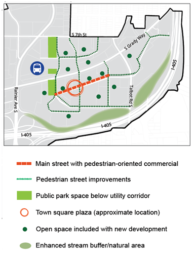
2. Authority: The Administrator shall have discretion to stipulate the location, design, and improvements to qualify public park space for the purposes of administering bonus density or bonus height provisions of this Section, or to satisfy the open space requirements of this subsection.
3. Guidelines: Public open space shall be consistent with the following principles:
a. Public open space should be open to the sky except where overhead weather protection is provided (e.g., awnings, canopies, limited areas with cantilevered upper stories).
b. The space should appear and function as public space rather than private space.
c. A combination of lighting, paving, landscaping, and seating should be utilized to enhance the pedestrian experience within the public open space.
d. The space should provide direct visual and physical connections to the surrounding public streets, pathways, parks, and open spaces.
e. Spaces should provide year-round public use and access.
f. Spaces should maximize safety, comfort, and amenities for pedestrians.
g. Open space should connect with through-block connections, where possible.
h. Space should be oriented to receive sunlight, facing east, west or (preferably) south, when possible; and
i. When a public space is privately owned, it should be properly signed to welcome the public where appropriate.
4. Standards for Plazas: Plazas shall be pedestrian-oriented spaces.
a. A pedestrian-oriented space shall have:
i. Visual and pedestrian access (including access compliant with the Americans with Disabilities Act) into the site from a street, private access road, or nonvehicular courtyard;
ii. Paved walking surfaces of either concrete or approved unit paving;
iii. An overlapping pattern of light and lighting levels designed to allow pedestrians to identify a face thirty feet (30') away, generally at least three (3) footcandles. Lighting shall be pedestrian-scaled, compatible with the landscape design, and improve safety;
iv. A location in areas with significant pedestrian traffic to provide interest and security, such as adjoining to a building entry;
v. Weather protection for pedestrians at key intersections, building entrances, and points of interest;
vi. No less than twenty feet (20') in any dimension; provided, that to allow for variation, open space(s) of less than the minimum dimension are allowed if the averaged dimensions equal the minimum;
vii. Landscaping components that add visual interest and do not act as a visual barrier. This could include planting beds, potted plants, or both; and
viii. At least two feet (2') of seating area (a bench or ledge at least sixteen inches (16") deep and appropriate seating height) or one individual seat per sixty (60) square feet of plaza area or open space.
b. A pedestrian-oriented space is encouraged to have:
i. Pedestrian amenities, such as a water feature, site furniture, artwork, drinking fountains, kiosks, bicycle parking, etc.;
ii. Adjoining buildings with transparent windows and doors covering seventy-five percent (75%) of the facade between two feet (2') and eight feet (8') above the ground level;
iii. Features and programming opportunities to encourage year-round use;
iv. Design for events where feasible by providing electrical hookups and areas for staging;
v. Consideration of the sun angle at noon and the wind pattern in the design of the space; and
vi. Transitional zones along building edges to allow for outdoor seating areas and a planted buffer.
c. A pedestrian-oriented space shall not have:
i. Asphalt or gravel pavement;
ii. Adjoining nonbuffered parking lots or service areas;
iii. Adjacent chain-link fences;
iv. Adjoining blank walls; and
v. Outdoor storage or retail sales that do not contribute to the pedestrian-oriented environment.
5. Requirements:
a. Each site shall dedicate a minimum of ten percent (10%) of the site area or ten thousand (10,000) square feet, whichever is less, as one or more public open spaces, which may be in the form of public plazas or public parks. Open space required by other Sections of Title IV RMC may be counted to satisfy this requirement, but the minimum site area dedication required by this Section shall not supersede open space requirements of other Sections (i.e., if the amount of required open space required by other Sections equals more than ten percent (10%) or ten thousand (10,000) square feet, whichever is less, of a site, the requirements of other Sections shall supersede this Section’s minimum open space requirement). This requirement shall not qualify as a land dedication to grant bonus density or bonus height pursuant to subsection G or H of this Section, provided land dedication for such purposes may be added to the public open space required by this subsection for said purposes.
b. The Administrator may allow the land dedication to be off site if such dedication contributes to the creation of the Town Square Plaza or other large open space areas.
c. The area(s) necessary to meet minimum required through-block connections do not qualify as pedestrian-oriented space. However, if pathway and sidewalk widths are widened beyond the required width and the applicable area meets the definition of pedestrian-oriented space, then that area shall qualify as pedestrian-oriented space.
d. Buildings shall be set back at least ten feet (10') from the edge of pedestrian-oriented space. If a transitional zone with features such as seating areas or a landscaped buffer is provided within the setback then that area shall contribute to the required pedestrian-oriented space.
e. Pedestrian-oriented space shall provide access that complies with the Americans with Disabilities Act; additional access may be provided through the building if necessary to meet this requirement.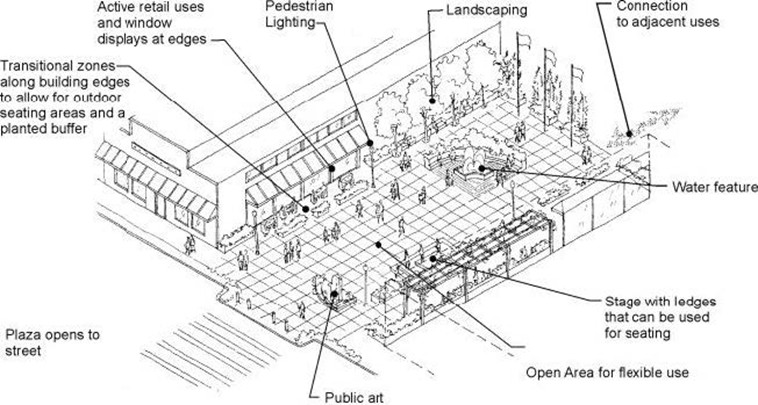
J. STREET STANDARDS:
1. Purpose: The purpose of this subsection is to ensure the development of a street network to support a multimodal neighborhood with a vibrant mix of residential and commercial uses. Safe multimodal access is essential to the vision and the success of the Subarea Plan. The improvements and recommendations identified in the Subarea Plan are conceptual, indicating the locations and the types of multimodal improvements needed to support the vision.
Final street designs shall be approved by the Administrator, shall be consistent with the conceptual locations and designs of the Subarea Plan’s street grid and cross-sections, and shall provide strong multimodal connectivity, human-scale block sizes, mid-block crossings, movable bollards, street furniture, lighting standards, opportunities for on-street parking, and loading and unloading areas. Intersection designs shall be approved by the Administrator, and roundabouts shall be the preferred design, followed by raised intersections. The potential to provide curb-less transitions from sidewalk to street shall be considered along Main Street to encourage and facilitate use as a festival street.
2. Applicability: The conceptual street standards and network in the Subarea Plan will be used for all public and private street improvements within the RGJ Overlay. Whenever a building permit is applied for or application made for a short plat or a full subdivision, the applicant for such permit and/or application shall build and install certain street improvements, including, but not limited to: lighting, curb, sidewalk, and landscaping on all abutting rights-of-way, and all private street improvements on access easements.
K. THROUGH-BLOCK CONNECTIONS:
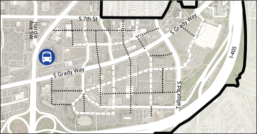
1. Purpose: The purpose of this subsection is to ensure the creation of through-block pedestrian connections, where appropriate, to break up larger street blocks or larger development parcels and to increase and enhance the overall multimodal accessibility and walkability of the area. The image above illustrates the conceptual configuration of several through-block connections (dotted lines) intended to primarily enhance pedestrian circulation in the area, while also providing an option for vehicular access to on-site parking, functioning as a design amenity to new development, and breaking up the massing of buildings on long blocks.
Public through-block connections are most important within long blocks to provide an efficient pedestrian network to connect to adjacent streets and destinations such as open spaces and transit stops/stations. These connections should be high-quality, open to the sky and wide enough to allow pedestrians and cyclists to pass through comfortably, and others to pause and sit or access building entrances. They should be highlighted through retail that wraps the corner, public art, signage, or other design elements that draw people into the connection from the sidewalk or other public realm. Landscaping creates visual interest, and elements such as paving, lighting, seating, planters, and trees should make the connection more inviting. Small-scale, urban recreational uses could also be considered in these spaces.
2. Guidelines: A through-block pedestrian connection shall:
a. Form logical routes from its origin to its destination;
b. Offer diversity in terms of activities and pedestrian amenities;
c. Incorporate design elements of the adjacent right-of-way, such as paving, lighting, landscaping, and signage to identify the through-block connection as a public space;
d. Accentuate and enhance access to the through-block pedestrian connection from the right-of-way by use of multiple points of entry that identify it as a public space;
e. Identify the connection as a public space through clear and visible signage;
f. Provide an overlapping pattern of light and lighting levels designed to allow pedestrians to identify a face thirty feet (30') away, generally at least three (3) footcandles. Lighting shall be pedestrian-scaled, compatible with the landscape design, and improve safety;
g. Provide high-quality design and durable materials;
h. Provide landscaping to define and animate the space wherever possible;
i. Incorporate trees and landscaping to provide enclosure and soften the experience of the built environment;
j. The use of artistic elements and water features is encouraged to provide moments of interest for the user;
k. Provide access that complies with the Americans with Disabilities Act. Additional access may be provided through the building, if necessary to meet this requirement;
l. Provide weather protection for pedestrians at key intersections, building entrances, or points of interest;
m. Upon the approval of Administrator, be developed as a walkway or a combination raised walkway and vehicular lane, each with distinct materials and separated by a buffer;
n. Incorporate decorative lighting and seating areas; and
o. Be visible from surrounding spaces and uses. Provide windows, doorways, and other devices on the through-block connection to ensure that the connection is used, feels safe, and is not isolated from view.
3. Standards:
a. Locations: Through-block pedestrian connections are required as shown in the map above or at the approximate mid-points of blocks. In areas not identified on the map, one pedestrian walkway shall be provided, on average, every three hundred feet (300'), but not so frequently that street walls are unnecessarily interrupted, or the urban form disjointed, which can adversely affect pedestrian activity and safety. Exact locations of pedestrian walkways shall be determined at the time of development to accommodate linkages between adjacent developments. A through-block pedestrian connection shall be outdoors, except where it can only be accommodated indoors, in which case it shall be open to the public for the same hours during which the building is open to the public.
b. Minimum/Average Width: Pedestrian walkways shall be a minimum of eight feet (8') wide with a minimum average width of twelve feet (12'). The minimum/average walkway width does not include additional areas that may be required for landscaping or furnishings.
c. Signage: Directional signage shall identify circulation routes for all users and state the hours that the space is accessible to the public. The signage shall be visible from all points of access.
d. Lines of Sight: Locate walkways with clear sight lines for safety. Landscaping and site furnishings in the walkway shall not obstruct visibility of the walkway or sight lines to building entrances.
e. Clearly Defined Walkways: Define all pedestrian walkways using a combination of one or more of the following techniques: Scored concrete, stained/colored concrete, concrete pavers, paving inlays, mosaics, or other special paving material. Not all portions of the pedestrian walkway are required to be paved; however, a minimum of sixty percent (60%) of the pedestrian walkway shall provide an all-weather walking surface.
f. Architectural Features: Trellises, railing, low seat walls, weather protection, bollards, or other architectural features. Chain link fences are not allowed.
g. Landscaped Edges: A continuous, landscaped area a minimum of three feet (3') wide flanking at least one side of the pedestrian walkway.
h. Lighting: Pedestrian walkways shall include lighting such as pedestrian lights, bollards, and accent lighting to assist pedestrian navigation and promote a safe and comfortable walking space. An overlapping pattern of light and lighting levels designed to allow pedestrians to identify a face thirty feet (30') away, generally at least three (3) footcandles. Lighting shall be pedestrian-scaled, compatible with the landscape design, and improve safety.
i. Proportionate Share: If a new development is built adjacent to a required through-block pedestrian connection as provided in the map, the applicant shall construct a proportionate share of the through-block pedestrian connection necessary to support its function.
j. Hours: A through-block pedestrian connection shall be open to the public twenty-four (24) hours a day. Provided, if the through-block pedestrian connection is within a building, its hours shall coincide with the hours during which the building is open to the public.
k. Prohibited Activities: Loading, refuse handling, parking, and other building and site service uses shall not occur in through-block connections unless reasonable alternatives are not feasible. When the above-referenced activities must be incorporated into a through-block connection, operational procedures shall require the above-referenced activities to occur after normal business hours.
l. Legal Agreement: Owners of property who are required to provide a through-block connection shall execute a legal agreement providing that such property is subject to a nonexclusive right of pedestrian use and access by the public during hours of operation.
L. GREEN FACTOR STANDARDS:
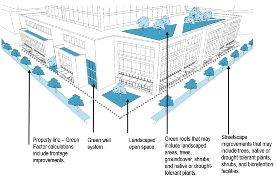
1. Purpose: The purpose of this subsection is to ensure that new development provides high quality landscaping and other sustainability elements that contribute to an attractive outdoor environment, provide stormwater management, create habitats for birds, insects, and other wildlife, and help mitigate the effects of extreme heat.
2. Applicability: The provisions of RMC 4-4-070, Landscaping, shall apply to all new development in the RGJ Overlay, and all resulting required landscaping by this Section shall contribute to the Green Factor Score. The requirements of this subsection shall apply to the entire site, all parking areas, and street frontages in any of the following cases:
a. All new buildings and new storm drainage facilities;
b. Additions to existing buildings that increase the gross square footage of the building by greater than one-third (1/3);
c. Conversion of vacant land;
d. Conversion of a residential use to a nonresidential use; and
e. Other changes in the use of a property or remodel of a structure that requires improvements equal to or greater than fifty percent (50%) of the assessed property valuation.
3. Requirements: Applicable projects within the RGJ Overlay shall provide landscaping and other elements that meet a Green Factor Score of 0.4 or greater. All landscaping and other elements shall meet the standards promulgated by the Administrator or designee for the long-term health, viability, and coverage of plantings. The Green Score shall be calculated as follows:
a. Identify all proposed elements, sorted into categories presented in the Green Factor Values Table.
b. Multiply the square feet, or equivalent unit of measurement where applicable, of each landscape element by the multiplier provided for that element in the Green Factor Values Table according to the following provisions:
i. If multiple elements listed in the Green Factor Values Table occupy the same physical area, they may all be counted. For example, groundcover and trees occupying the same physical space may be counted under the groundcover element and the tree element.
ii. Landscaping elements in the right-of-way between the lot line and the roadway may be counted; provided, that they are approved by the Administrator or designee.
iii. Elements in the Green Factor Values Table that are provided to satisfy any other requirements of this Section count toward the Green Factor score.
iv. For trees, large shrubs, and large perennials, use the equivalent square footage of each according to the Green Factor Values Table.
v. For vegetated walls, use the square footage portion of the wall that will be covered by vegetation. All vegetated wall structures, including fences counted as vegetated walls, shall be constructed of durable materials, provide adequate planting area for plant health, and provide appropriate surfaces or structures that enable plant coverage. Vegetated walls shall include year-round irrigation and a submitted maintenance plan shall be included as an element in the calculation for a project’s Green Factor Score.
vi. For all elements other than trees, large shrubs, perennials, vegetated walls, structural soil systems and soil cell system volume, square footage is determined by the area the portion of the horizontal plane that lies over or under the element.
vii. All permeable paving and structural soil credits combined may not count for more than one-third (1/3) of the project’s Green Factor Score.
viii. Unless otherwise noted, elements shall be counted in feet.
ix. An Innovation credit may be awarded at the discretion of the Administrator or designee. This credit can be awarded if a development seeks innovative ways to support the vision and goals of the Subarea Plan. The multiplier may range from 0.2 to 0.5 depending on the proposal.
c. Add together all the products calculated under Table A to determine the Green Factor numerator.
d. Divide the Green Factor numerator by the lot area to determine the Green Score.
e. The Administrator or designee has the final authority determining the accuracy of the calculation of the Green Factor Score.
Green Factor Values Table
|
Landscape Elements |
Multiplier |
|
|
Bioretention Facilities and Soil Cells |
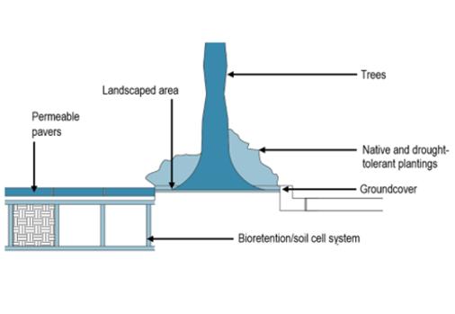
Bioretention facilities shall comply with the City’s Surface Water Design Manual and RMC 4-6-040, Drainage and Water Quality Standards. Bioretention facilities shall be calculated in horizontal square feet. The volume of the facility shall be calculated using three feet (3') of depth or the depth of the facility, whichever is less. |
1.2 |
|
Soil Cell Pavement Support Systems |
Soil cell systems shall provide a minimum of twenty feet by five feet (20' by 5') tree pits to provide trees with healthy root growth and better growing conditions without compromising surfaces and underground utilities. |
1.2 |
|
Structural Soil Systems |
The volume of structural soil systems can be calculated up to three feet (3') in depth. The volume of structural soil systems shall be calculated in cubic feet. The volume of the facility shall be calculated using three feet (3') of depth or the depth of the facility, whichever is less. |
0.2 |
|
Landscaped Areas with Soil Depth Less than Twenty-Four Inches (24") |
|
0.1 |
|
Landscaped Areas with Soil Depth of Twenty-Four Inches (24") or More |
|
0.6 |
|
Trees, Shrubs and Perennials |
Multiplier |
|
|
Ground Cover |
Ground covers or other low plants less than or equal to two feet (2') tall at maturity. |
0.1 |
|
Tree Preservation |
Existing trees – proposed for preservation shall be calculated at twenty (20) per inch of trunk diameter at four and one-half feet (4.5') above grade. |
1.0 |
|
Preservation of Existing Evergreen Trees Bonus |
Existing evergreen trees proposed for this bonus shall be calculated at twenty (20) per inch of trunk diameter and shall have a minimum diameter of six inches (6") at four and one-half feet (4.5') above grade. |
0.1 |
|
Shrubs and Perennials – Medium |
Shrubs or medium perennials that are between two to four feet (2 – 4') tall at maturity shall be calculated at nine (9) square feet per plant. |
0.3 |
|
Shrubs and Perennials – Large |
Shrubs or large perennials that are greater than four feet (4') tall at maturity shall be calculated at thirty-six (36) square feet per plant. |
0.4 |
|
Small Trees |
Small trees shall be calculated at ninety (90) per tree with a canopy spread of ten to fifteen feet (10' – 15') at maturity. Consult the Green and Sustainability Factor Tree List for size classification of trees. |
0.3 |
|
Medium Trees |
Medium trees shall be calculated at two hundred thirty (230) square feet per tree. Consult the Green Tree List for size classification of trees. |
0.5 |
|
Large Trees |
Large trees shall be calculated at three hundred sixty (360) square feet per tree. Consult with the Green Factor Tree List for size classification of trees. |
0.7 |
|
Green Roofs |
Multiplier |
|
|
Two to Four Inches (2" – 4") of Growth Medium |
Roof area planted with at least two inches (2") of growth medium, but less than four inches (4") of growth medium. |
0.4 |
|
Greater than Four Inches (4") |
Roof area planted with at least four inches (4") of growth medium. |
0.7 |
|
Green Walls |
Multiplier |
|
|
Vegetated Wall |
Facade or structural surface obscured by vines. Vine coverage shall be calculated with an estimate of three (3) years’ growth. A year-round irrigation and maintenance plan shall be provided. |
0.2 |
|
Green Wall System |
Facade or structural surface planted with a green wall system. A year-round irrigation and maintenance plan shall be provided. |
0.7 |
|
Landscape Bonuses |
Multiplier |
|
|
Food Cultivation |
Planting for food cultivation. |
0.2 |
|
Native or Drought-Tolerant Landscaping |
Planting of native or drought-tolerant plants. |
0.1 |
|
Landscape Areas |
Includes but not limited to the general streetscape (e.g., landscape strips, planter islands at sidewalk grade, and other on-site planter islands). |
0.1 |
|
Rainwater Harvesting |
Rainwater harvesting for landscape irrigation shall be calculated as a percentage of total water budget times total landscape area. |
0.2 |
|
Permeable Paving |
Multiplier |
|
|
Six to Twenty-Four Inches (6" – 24") of Soil or Gravel |
Permeable paving greater than six inches (6") and less than twenty-four inches (24") of soil or gravel. |
0.2 |
|
Greater than Twenty-Four Inches (24") of Soil or Gravel |
Permeable paving greater than twenty-four inches (24") of soil or gravel. |
0.5 |
|
Innovation |
|
Multiplier |
|
Innovation Credit Awarded at Discretion of Administrator or Designee. |
Applies to items not included in this list, but which support the vision and goals of the Subarea Plan. |
0.2 – 0.5 |
M. . AIR AND NOISE POLLUTION MITIGATION:
1. All new buildings constructed partially or wholly within five hundred feet (500') of I-405, as depicted in the map below, shall:
a. Provide double-glazed windows that do not open;
b. Not provide balconies on any side of a building facing I-405;
c. Provide a centralized air filtration system;
d. Use MERV 13 filters (or above) for air handling units for the HVAC system;
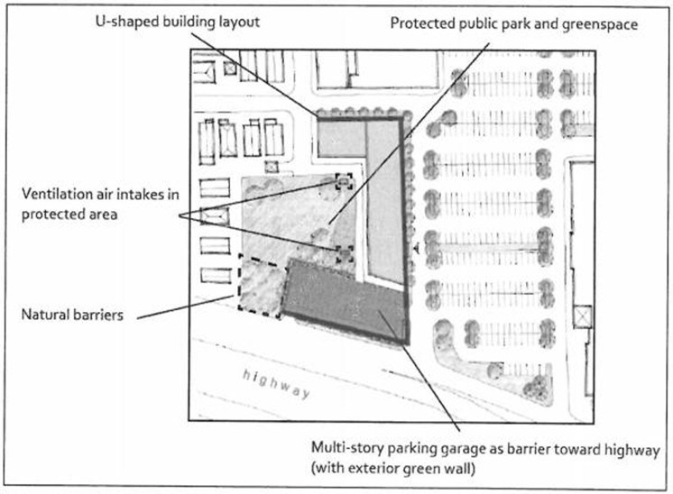
e. Locate outdoor air intakes for the HVAC system as far as possible from I-405 (e.g., on rooftops, facades not facing I-405, or located in areas shielded from prevailing winds from highway);
f. Design buildings with varying shapes and heights to help break up air pollution emission plumes, increase air flow, and help reduce pollutants such as particulates and noise; and
g. Where possible, building design, landscaping, and greenspaces should be designed to block prevailing winds from building entries and outdoor areas.
2. The Administrator shall have discretion to approve alternative methods to mitigate air and noise pollution provided the alternatives are comparable or superior to the standards above.
N. MODIFICATIONS:
The Administrator shall have the authority to modify the standards of this Section, subject to the provisions of RMC 4-9-250D, Modification Procedures. (Ord. 6151, 11-25-2024)