


Chapter 22.16
FLOOD DAMAGE PREVENTION
Sections:
22.16.010 Authority, findings of fact, purpose and objectives.
22.16.050 Provisions for flood hazard reduction.
22.16.010 Authority, findings of fact, purpose and objectives.
A. Statement of Authority. The Legislature of the state of Washington has delegated the responsibility to local governmental units to adopt regulations designed to promote the public health, safety, and general welfare of its citizenry. Consistent with this authority, the Richland city council finds that:
1. The flood hazard areas of Richland are subject to periodic inundation, which results in loss of life and property, health and safety hazards, disruption of commerce and governmental services, extraordinary public expenditures for flood protection and relief, and impairment of the tax base, all of which adversely affect the public health, safety, and general welfare.
2. These flood losses are caused by the cumulative effect of obstructions in areas of special flood hazards that increase flood heights and velocities, and when inadequately anchored, damage uses in other areas. Uses that are inadequately flood-proofed, elevated, or otherwise protected from flood damage also contribute to the flood loss.
B. Statement of Purpose. The purpose of this chapter is to promote the public health, safety, and general welfare; reduce the annual cost of flood insurance; and minimize public and private losses due to flood conditions in specific areas by provisions designed to:
1. Protect human life and health;
2. Minimize expenditure of public money for costly flood control projects;
3. Minimize the need for rescue and relief efforts associated with flooding and generally undertaken at the expense of the general public;
4. Minimize prolonged business interruptions;
5. Minimize damage to public facilities and utilities, such as water and gas mains; electric, telephone, and sewer lines; and streets and bridges located in flood hazard areas;
6. Help maintain a stable tax base by providing for the sound use and development of flood hazard areas so as to minimize blight areas caused by flooding;
7. Notify potential buyers that the property is in a special flood hazard area;
8. Notify those who occupy flood hazard areas that they assume responsibility for their actions; and
9. Participate in and maintain eligibility for flood insurance and disaster relief.
C. Methods of Reducing Flood Losses. In order to accomplish its purposes, this chapter includes methods and provisions for:
1. Restricting or prohibiting uses that are dangerous to health, safety, and property due to water or erosion hazards, or which result in damaging increases in erosion or in flood heights or velocities;
2. Requiring that uses vulnerable to floods, including facilities that serve such uses, be protected against flood damage at the time of initial construction;
3. Controlling the alteration of natural floodplains, stream channels, and natural protective barriers, which help accommodate or channel floodwaters;
4. Controlling filling, grading, dredging, and other development, which may increase flood damage; and
5. Preventing or regulating the construction of flood barriers that unnaturally divert floodwaters or may increase flood hazards in other areas. [Ord. 59-19 § 2].
22.16.020 Definitions.
Unless specifically defined below, words or phrases used in this chapter shall be interpreted so as to give them the meaning they have in common usage and to give this chapter its most reasonable application.
“Alteration of watercourse” means any action that will change the location of the channel occupied by water within the banks of any portion of a riverine water body.
“Appeal” means a request for a review of the interpretation of any provision of this chapter or a request for a variance.
“Area of shallow flooding” means a designated zone AO, AH, AR/AO or AR/AH (or VO) on a community’s flood insurance rate map (FIRM) with a one percent or greater annual chance of flooding to an average depth of one to three feet where a clearly defined channel does not exist, where the path of flooding is unpredictable, and where velocity flow may be evident. Such flooding is characterized by ponding or sheet flow. Also referred to as the sheet flow area.
“Area of special flood hazard” means the land in the floodplain within a community subject to a one percent or greater chance of flooding in any given year. It is shown on the flood insurance rate map (FIRM) as zone A, AO, AH, A1-30, AE, A99, AR (V, VO, V1-30, VE). “Special flood hazard area” is synonymous in meaning with the phrase “area of special flood hazard.”
“Base flood” means any flood having a one percent chance of being equaled or exceeded in any given year (also referred to as the “100-year flood”).
“Base flood elevation (BFE)” means the elevation to which floodwater is anticipated to rise during the base flood.
“Basement” means any area of the building having its floor sub-grade (below ground level) on all sides.
“Breakaway wall” means a wall that is not part of the structural support of the building and is intended through its design and construction to collapse under specific lateral loading forces, without causing damage to the elevated portion of the building or supporting foundation system.
Building. See “Structure.”
“Community” means a county or city government, as well as a tribal, federal, or state agency with permitting or project approval authority within special flood hazard areas.
“Critical facility” means a facility for which even a slight chance of flooding might be too great. Critical facilities include, but are not limited to, schools, nursing homes, hospitals, police, fire and emergency response installations, and installations which produce, use, or store hazardous materials or hazardous waste.
“Development” means any manmade change to improved or unimproved real estate, including but not limited to buildings or other structures, mining, dredging, filling, grading, paving, excavation or drilling operations or storage of equipment or materials located within the area of special flood hazard.
“Elevated building” means, for insurance purposes, a nonbasement building that has its lowest elevated floor raised above ground level by foundation walls, shear walls, post, piers, pilings, or columns.
“Elevation certificate” means an administrative tool of the National Flood Insurance Program (NFIP) that can be used to provide elevation information, to determine the proper insurance premium rate, and to support a request for a letter of map amendment (LOMA) or letter of map revision based on fill (LOMR-F).
“Existing manufactured home park or subdivision” means a manufactured home park or subdivision for which the construction of facilities for servicing the lots on which the manufactured homes are to be affixed (including, at a minimum, the installation of utilities, the construction of streets, and either final site grading or the pouring of concrete pads) is completed before the effective date of the adopted floodplain management regulations adopted by the community.
“Expansion to an existing manufactured home park or subdivision” means the preparation of additional sites by the construction of facilities for servicing the lots on which the manufactured homes are to be affixed (including the installation of utilities, the construction of streets, and either final site grading or the pouring of concrete pads).
“Farmhouse” means a single-family dwelling located on a farm site where resulting agricultural products are not produced for the primary consumption or use by the occupants and the farm owner.
“Flood” or “flooding” means:
1. A general and temporary condition of partial or complete inundation of normally dry land areas from:
a. The overflow of inland or tidal waters;
b. The unusual and rapid accumulation or runoff of surface waters from any source; or
c. Mudslides (i.e., mudflows) which are proximately caused by flooding as defined in subsection (1)(b) of this definition and are akin to a river of liquid and flowing mud on the surfaces of normally dry land areas, as when earth is carried by a current of water and deposited along the path of the current.
2. The collapse or subsidence of land along the shore of a lake or other body of water as a result of erosion or undermining caused by waves or currents of water exceeding anticipated cyclical levels or suddenly caused by an unusually high water level in a natural body of water, accompanied by a severe storm, or by an unanticipated force of nature, such as flash flood or an abnormal tidal surge, or by some similarly unusual and unforeseeable event which results in flooding as defined in subsection (1) of this definition.
“Flood elevation study” means an examination, evaluation and determination of flood hazards and, if appropriate, corresponding water surface elevations, or an examination, evaluation and determination of mudslide (i.e., mudflow) and/or flood-related erosion hazards. Also known as a flood insurance study (FIS).
“Flood insurance rate map (FIRM)” means the official map of a community, on which the Federal Insurance Administrator has delineated both the special hazard areas and the risk premium zones applicable to the community. A FIRM that has been made available digitally is called a digital flood insurance rate map (DFIRM).
“Flood-proofing” means any combination of structural and nonstructural additions, changes, or adjustments to structures which reduce or eliminate risk of flood damage to real estate or improved real property, water and sanitary facilities, structures, and their contents. Flood-proofed structures are those that have the structural integrity and design to be impervious to floodwater below the base flood elevation.
“Floodplain” or “flood prone area” means any land area susceptible to being inundated by water from any source. See “Flood” or “flooding.”
“Floodplain administrator” means the community official designated by title to administer and enforce the floodplain management regulations.
“Floodplain management regulations” means zoning ordinances, subdivision regulations, building codes, health regulations, special purpose ordinances (such as floodplain ordinance, grading ordinance and erosion control ordinance) and other application of police power. The term describes such state or local regulations, in any combination thereof, which provide standards for the purpose of flood damage prevention and reduction.
“Floodway” means the channel of a river or other watercourse and the adjacent land areas that must be reserved in order to discharge the base flood without cumulatively increasing the water surface elevation more than a designated height (not more than one foot). Also referred to as “regulatory floodway.”
“Functionally dependent use” means a use which cannot perform its intended purpose unless it is located or carried out in close proximity to water. The term includes only docking facilities, port facilities that are necessary for the loading and unloading of cargo or passengers, and ship building and ship repair facilities, and does not include long-term storage or related manufacturing facilities.
“Highest adjacent grade” means the highest natural elevation of the ground surface prior to construction next to the proposed walls of a structure.
“Historic structure” means any structure that is:
1. Listed individually in the National Register of Historic Places or preliminarily determined by the Secretary of the Interior as meeting the requirements for individual listing on the National Register;
2. Certified or preliminarily determined by the Secretary of the Interior as contributing to the historical significance of a registered historic district or a district preliminarily determined by the Secretary to qualify as a registered historic district;
3. Individually listed on a state inventory of historic places in states with historic preservation programs which have been approved by the Secretary of the Interior; or
4. Individually listed on a local inventory of historic places in communities with historic preservation programs that have been certified either:
a. By an approved state program as determined by the Secretary of the Interior; or
b. Directly by the Secretary of the Interior in states without approved programs.
“Lowest floor” means the lowest floor of the lowest enclosed area, including the basement. An unfinished or flood resistant enclosure, usable solely for parking of vehicles, building access, or storage in an area other than a basement area, is not considered a building’s lowest floor; provided, that such enclosure is not built so as to render the structure in violation of the applicable nonelevation design requirements of this chapter (i.e., provided there are adequate flood ventilation openings).
“Manufactured home” means a structure, transportable in one or more sections, which is built on a permanent chassis and is designed for use with or without a permanent foundation when attached to the required utilities. The term “manufactured home” does not include a “recreational vehicle.”
“Manufactured home park or subdivision” means a parcel (or contiguous parcels) of land divided into two or more manufactured home lots for rent or sale.
“Mean sea level for purposes of the National Flood Insurance Program” means the vertical datum to which base flood elevations shown on a community’s flood insurance rate map are referenced.
“New construction for the purposes of determining insurance rates” means structures for which the “start of construction” commenced on or after the effective date of an initial flood insurance rate map or after December 31, 1974, whichever is later, and includes any subsequent improvements to such structures. For floodplain management purposes, “new construction” means structures for which the “start of construction” commenced on or after the effective date of a floodplain management regulation adopted by a community and includes any subsequent improvements to such structures.
“New manufactured home park or subdivision” means a manufactured home park or subdivision for which the construction of facilities for servicing the lots on which the manufactured homes are to be affixed (including, at a minimum, the installation of utilities, the construction of streets, and either final site grading or the pouring of concrete pads) is completed on or after the effective date of adopted floodplain management regulations adopted by the community.
One-Hundred-Year Flood or 100-Year Flood. See “Base flood.”
“Reasonably safe from flooding” means development that is designed and built to be safe from flooding based on consideration of current flood elevation studies, historical data, high water marks and other reliable data known to the community. In unnumbered A zones where flood elevation information is not available and cannot be obtained by practicable means, “reasonably safe from flooding” means that the lowest floor is at least two feet above the highest adjacent grade.
“Recreational vehicle” means a vehicle:
1. Built on a single chassis;
2. Four hundred square feet or less when measured at the largest horizontal projection;
3. Designed to be self-propelled or permanently towable by a light duty truck; and
4. Designed primarily not for use as a permanent dwelling but as temporary living quarters for recreational, camping, travel, or seasonal use.
“Start of construction” means and includes substantial improvement and means the date the building permit was issued, provided the actual start of construction, repair, reconstruction, rehabilitation, addition, placement, or other improvement was within 180 days from the date of the permit. The “actual start” means either the first placement of permanent construction of a structure on a site, such as the pouring of slab or footings, the installation of piles, the construction of columns, or any work beyond the stage of excavation; or the placement of a manufactured home on a foundation. Permanent construction does not include land preparation, such as clearing, grading, and filling; nor does it include the installation of streets and/or walkways; nor does it include excavation for a basement, footings, piers, or foundations or the erection of temporary forms; nor does it include the installation on the property of accessory buildings, such as garages or sheds not occupied as dwelling units or not part of the main structure. For a substantial improvement, the “actual start of construction” means the first alteration of any wall, ceiling, floor, or other structural part of a building, whether or not that alteration affects the external dimensions of the building.
“Structure for floodplain management purposes” means a walled and roofed building, including a gas or liquid storage tank that is principally above ground, as well as a manufactured home.
“Substantial damage” means damage of any origin sustained by a structure whereby the cost of restoring the structure to its before-damaged condition would equal or exceed 50 percent of the market value of the structure before the damage occurred.
“Substantial improvement” means any reconstruction, rehabilitation, addition, or other improvement of a structure, the cost of which equals or exceeds 50 percent of the market value of the structure before the “start of construction” of the improvement. This term includes structures which have incurred “substantial damage,” regardless of the actual repair work performed. The term does not, however, include either:
1. Any project for improvement of a structure to correct existing violations of state or local health, sanitary, or safety code specifications that have been identified by the local code enforcement official and that are the minimum necessary to assure safe living conditions; or
2. Any alteration of a “historic structure”; provided, that the alteration will not preclude the structure’s continued designation as a “historic structure.”
“Variance” means a grant of relief by a community from the terms of a floodplain management regulation.
“Violation” means the failure of a structure or other development to be constructed or implemented in conformance with the community’s applicable floodplain development regulations.
“Water dependent” means a structure for commerce or industry that cannot exist in any other location and is dependent on the water by reason of the intrinsic nature of its operations.
“Water surface elevation” means the height in relation to the vertical datum utilized in the applicable flood insurance study of floods of various magnitudes and frequencies in the floodplains of coastal or riverine areas. [Ord. 59-19 § 2].
22.16.030 General provisions.
A. Lands to Which This Chapter Applies. This chapter shall apply to all special flood hazard areas within the boundaries of the city of Richland, Washington.
B. Basis for Establishing the Areas of Special Flood Hazard. The special flood hazard areas identified by the Federal Insurance Administrator in scientific and engineering reports entitled “The Flood Insurance Study (FIS) for the City of Richland, Washington” dated December 1979, and the “Flood Insurance Study for Benton County, Washington” dated June 1994, and any revisions thereto, with accompanying flood insurance rate maps (FIRMs) and floodway maps, and any revisions thereto, are hereby adopted by reference and declared to be a part of this chapter. The FIS and the FIRM are on file at the city of Richland development services department. The best available information for flood hazard area identification as outlined in RMC 22.16.040(C)(2) shall be the basis for regulation until a new FIRM is issued that incorporates data utilized under RMC 22.16.040(C)(2).
C. Compliance. All development within special flood hazard areas is subject to the terms of this chapter and other applicable regulations.
D. Penalties for Noncompliance. No structure or land shall hereafter be constructed, located, extended, converted, or altered without full compliance with the terms of this chapter and other applicable regulations. Violations of the provisions of this chapter by failure to comply with any of its requirements (including violations of conditions and safeguards established in connection with conditions) shall be a civil violation punishable as set forth in Chapter 1.30 RMC; provided, however, that all remedies available to the city for violation of this chapter are cumulative, and nothing herein contained shall prevent the city from taking such other lawful action as is necessary to prevent or remedy any violation.
E. Abrogation and Greater Restrictions. Nothing contained herein is intended to repeal, abrogate, or impair any existing easements, covenants or deed restrictions. However, where this chapter and another regulation, easement, covenant or deed restriction conflict or overlap, whichever imposes the more stringent restrictions shall prevail.
F. Interpretation. In the interpretation and application of this chapter, all provisions shall be:
1. Considered as minimum requirements;
2. Liberally construed in favor of the governing body; and
3. Deemed neither to limit nor repeal any other powers granted under state statutes.
G. Warning and Disclaimer of Liability. The degree of flood protection required by this chapter is considered reasonable for regulatory purposes and is based on scientific and engineering considerations. Larger floods can and will occur on rare occasions. Flood heights may be increased by manmade or natural causes. This chapter does not imply that land outside the areas of special flood hazard or uses permitted within such areas will be free from flooding or flood damages. This chapter shall not create liability on the part of the city, any officer or employee thereof, or the Federal Insurance Administration, for any flood damages that result from reliance on this chapter or any administrative decision lawfully made hereunder.
H. Severability. This chapter and the various parts thereof are hereby declared to be severable. Should any section of this chapter be declared by the courts to be unconstitutional or invalid, such decision shall not affect the validity of the chapter as a whole, or any portion thereof other than the section so declared to be unconstitutional or invalid. [Ord. 59-19 § 2].
22.16.040 Administration.
A. Establishment of Development Permit.
1. Development Permit Required. A development permit shall be obtained before construction or development begins within any area of special flood hazard established in RMC 22.16.030(B). The permit shall be for all structures including manufactured homes, as defined in this chapter, and for all development including fill and other activities, also as defined in this chapter.
2. Application for Development Permit. Application for a development permit shall be made on forms furnished by the floodplain administrator and may include, but not be limited to, plans in duplicate drawn to scale showing the nature, location, dimensions, and elevations of the area in question; existing or proposed structures, fill, storage of materials, drainage facilities, and the location of the foregoing. Specifically, the following information is required, in addition to payment of a fee as provided in the city’s posted fee schedule:
a. Elevation in relation to NAVD-88, of the lowest floor (including basement) of all structures, both prior to (pre-construction), and once construction is complete (post-construction), but prior to the city issuing a formal certificate of occupancy;
b. Elevation in relation to mean sea level to which any structure has been flood-proofed;
c. Where a structure is to be flood-proofed, certification by a registered professional engineer or architect that the flood-proofing methods for any nonresidential structure meet flood-proofing criteria in RMC 22.16.050(B)(3);
d. Description of the extent to which a watercourse will be altered or relocated as a result of proposed development. Additional information prepared by a registered professional engineer regarding the volumes of fill, amount of floodplain displacement, anchorage of structures or other technical issues not readily apparent at the time of application may be required as the review process proceeds;
e. Where development is proposed in a floodway, an engineering analysis indicating no rise of the base flood elevation; and
f. Any other such information that may be reasonably required by the floodplain administrator in order to review the application.
B. Designation of Floodplain Administrator. The development services director is hereby appointed to administer, implement, and enforce this chapter by granting or denying development permits in accordance with its provisions. The floodplain administrator may delegate authority to implement these provisions.
C. Duties and Responsibilities of the Floodplain Administrator. Duties of the floodplain administrator shall include, but not be limited to:
1. Permit Review. Review all development permits to determine that:
a. The permit requirements of this chapter have been satisfied;
b. All other required state and federal permits have been obtained;
c. The site is reasonably safe from flooding;
d. In areas where a floodway has not been designated, require that no new construction, substantial improvements or other development (including fill) shall be permitted within zones A1-30 and AE unless it is demonstrated that the cumulative effect of the proposed development, when combined with all other existing and anticipated development, will not increase the water surface elevation of the base flood more than one foot at any point within the community;
e. The proposed development is not located in the floodway. If located in the floodway, assure the encroachment provisions of RMC 22.16.050(D)(1) are met.
2. Use of Other Base Flood Data (in A and V Zones). When base flood elevation data has not been provided (in A or V zones) in accordance with RMC 22.16.030(B), the floodplain administrator shall obtain, review, and reasonably utilize any base flood elevation and floodway data available from a federal, state, or other source in order to administer RMC 22.16.050(B) related to specific standards, and RMC 22.16.050(D) related to floodways.
3. Information to Be Obtained and Maintained.
a. Where base flood elevation data is provided through the FIS, FIRM, or required as in subsection (C)(2) of this section, obtain and record the actual (as-built) elevation (in relation to mean sea level) of the lowest floor (including basement) of all new or substantially improved structures, and whether or not the structure contains a basement (44 CFR 60.3(b)(5)(i)).
b. Documentation of the bottom of the lowest horizontal structural member in V or VE zones.
c. For all new or substantially improved flood-proofed nonresidential structures where base flood elevation data is provided through the FIS, FIRM, or as required in subsection (C)(2) of this section:
i. Obtain and record the elevation (in relation to mean sea level) to which the structure was flood-proofed (44 CFR 60.3(b)(5)(ii)); and
ii. Maintain the flood-proofing certifications required in subsection (A)(2)(c) of this section (44 CFR 60.3(b)(5)(iii)).
d. Certification required by RMC 22.16.050(D) (floodway encroachments).
e. Records of all variance actions, including justification for their issuance.
f. Improvement and damage calculations.
g. Maintain for public inspection all records pertaining to the provisions of this chapter (44 CFR 60.3(b)(5)(iii)).
4. Notification to Other Entities. Whenever a watercourse is to be altered or relocated:
a. Notify adjacent communities and the Department of Ecology prior to such alteration or relocation of a watercourse, and submit evidence of such notification to the Federal Insurance Administrator through appropriate notification means; and
b. Assure that the flood carrying capacity of the altered or relocated portion of said watercourse is maintained.
5. Interpretation of FIRM Boundaries. Make interpretations where needed, as to exact location of the boundaries of the areas of special flood hazards (e.g., where there appears to be a conflict between a mapped boundary and actual field conditions). The person contesting the location of the boundary shall be given a reasonable opportunity to appeal the interpretation. Such appeals shall be granted consistent with the standards of Section 60.6 of the Rules and Regulations of the NFIP (44 CFR 59-76).
6. Review of Building Permits. Where elevation data is not available either through the FIS, FIRM, or from another authoritative source (see subsection (C)(2) of this section), applications for building permits shall be reviewed to assure that proposed construction will be reasonably safe from flooding. The test of reasonableness is a local judgment and includes use of historical data, high water marks, photographs of past flooding, etc., where available.
Note: Failure to elevate at least two feet above the highest adjacent grade in these zones may result in higher insurance rates.
7. Changes to Special Flood Hazard Areas.
a. If a project will alter the BFE or boundaries of the SFHA, then the project proponent shall provide the community with engineering documentation and analysis regarding the proposed change. If the change to the BFE or boundaries of the SFHA would normally require a letter of map change, then the project proponent shall initiate, and receive approval of, a conditional letter of map revision (CLOMR) prior to approval of the development permit. The project shall be constructed in a manner consistent with the approved CLOMR.
b. If a CLOMR application is made, then the project proponent shall also supply the full CLOMR documentation package to the floodplain administrator to be attached to the floodplain development permit, including all required property owner notifications. [Ord. 59-19 § 2; Ord. 63-19 § 6].
22.16.050 Provisions for flood hazard reduction.
A. General Standards. In all areas of special flood hazards, the following standards are required:
1. Anchoring.
a. All new construction and substantial improvements, including those related to manufactured homes, shall be anchored to prevent flotation, collapse, or lateral movement of the structure resulting from hydrodynamic and hydrostatic loads including the effects of buoyancy.
b. All manufactured homes shall be anchored to prevent flotation, collapse, or lateral movement, and shall be installed using methods and practices that minimize flood damage. Anchoring methods may include, but are not limited to, use of over-the-top or frame ties to ground anchors.
2. Construction Materials and Methods.
a. All new construction and substantial improvements shall be constructed with materials and utility equipment resistant to flood damage.
b. All new construction and substantial improvements shall be constructed using methods and practices that minimize flood damage.
c. Electrical, heating, ventilation, plumbing, and air-conditioning equipment and other service facilities shall be designed and/or otherwise elevated or located so as to prevent water from entering or accumulating within the components during conditions of flooding.
3. Storage of Materials and Equipment.
a. The storage or processing of materials that could be injurious to human, animal, or plant life if released due to damage from flooding is prohibited in special flood hazard areas.
b. Storage of other material or equipment may be allowed if not subject to damage by floods and if firmly anchored to prevent flotation, or if readily removable from the area within the time available after flood warning.
4. Utilities.
a. All new and replacement water supply systems shall be designed to minimize or eliminate infiltration of floodwaters into the systems;
b. Water wells shall be located on high ground that is not in the floodway;
c. New and replacement sanitary sewage systems shall be designed to minimize or eliminate infiltration of floodwaters into the systems and discharges from the systems into floodwaters;
d. On-site waste disposal systems shall be located to avoid impairment to them or contamination from them during flooding.
5. Subdivision Proposals and Development Greater Than 50 Lots or Five Acres. All subdivisions, as well as new development greater than 50 lots or five acres, whichever is the lesser, shall:
a. Be consistent with the need to minimize flood damage;
b. Have public utilities and facilities, such as sewer, gas, electrical, and water systems, located and constructed to minimize or eliminate flood damage;
c. Have adequate drainage provided to reduce exposure to flood damage.
d. Where base flood elevation data has not been provided or is not available from another authoritative source, it shall be generated for subdivision proposals and other proposed developments that contain at least 50 lots or five acres (whichever is less).
B. Specific Standards. In all areas of special flood hazards where base flood elevation data has been provided as set forth in RMC 22.16.030(B), Basis for Establishing the Areas of Special Flood Hazard, or RMC 22.16.040(C)(2), Use of Other Base Flood Data (in A and V Zones), the following provisions are required:
1. Residential Construction.
a. In AE and A1-30 zones or other A zoned areas where the BFE has been determined, new construction and substantial improvement of any residential structure shall have the lowest floor, including basement, elevated one foot or more above the BFE. Mechanical equipment and utilities shall be waterproofed or elevated at least one foot above the BFE.
b. New construction and substantial improvement of any residential structure in an unnumbered A zone for which a BFE is not available and cannot be reasonably obtained shall be reasonably safe from flooding, but in all cases the lowest floor shall be at least two feet above the highest adjacent grade.
c. Fully enclosed areas below the lowest floor that are subject to flooding are prohibited, or shall be designed to automatically equalize hydrostatic flood forces on exterior walls by allowing for the entry and exit of floodwaters. Designs for meeting this requirement must either be certified by a registered professional engineer or architect or must meet or exceed the following minimum criteria:
i. Have a minimum of two openings with a total net area of not less than one square inch for every square foot of enclosed area subject to flooding.
ii. The bottom of all openings shall be no higher than one foot above grade.
iii. Openings may be equipped with screens, louvers, valves, or other coverings or devices; provided, that they permit the automatic entry and exit of floodwater.
iv. A garage attached to a residential structure, constructed with the garage flood slab below the BFE, must be designed to allow for the automatic entry and exit of floodwaters.
2. Additional Requirements for Below-Grade Crawlspaces.
a. The interior grade of a crawlspace below the base flood elevation (BFE) must not be more than two feet below the lowest adjacent exterior grade (LAG), shown as D in Figure 1;
b. The height of the below-grade crawlspace, measured from the interior grade of the crawlspace to the top of the crawlspace foundation wall, must not exceed four feet (shown as L in Figure 1) at any point. The height limitation is the maximum allowable unsupported wall height according to the engineering analyses and building code requirements for flood hazard areas. This limitation will also prevent these crawlspaces from being converted into habitable spaces:
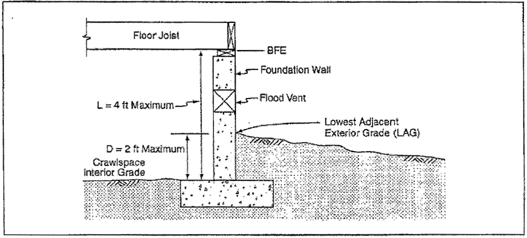
Figure 1
c. There must be an adequate drainage system that removes floodwaters from the interior area of the crawlspace. The enclosed area should be drained within a reasonable time after a flood event. The type of drainage system will vary due to variations in the site gradient and other drainage characteristics, such as soil types. Possible options include natural drainage through porous, well-drained soils and drainage systems such as perforated pipes, drainage tiles, or gravel or crushed stone drainage by gravity or mechanical means;
d. The velocity of floodwaters at the site should not exceed five feet per second for any crawlspace. For velocities in excess of five feet per second, other foundations should be used;
e. Any building utility systems within the crawlspace must be elevated above BFE or designed so that floodwaters cannot enter or accumulate within the system components during flood conditions. Ductwork, in particular, must either be placed above the BFE or sealed from floodwaters; and
f. Below-grade crawlspace construction in accordance with the requirements listed above will not be considered basements.
3. Nonresidential Construction. New construction and substantial improvement of any commercial, industrial or other nonresidential structure shall meet the requirements of subsection (B)(3)(a) or (b) of this section.
a. New construction and substantial improvement of any commercial, industrial or other nonresidential structure shall meet all of the following requirements:
i. In AE and A1-30 zones or other A zoned areas where the BFE has been determined or can be reasonably obtained, new construction and substantial improvement of any commercial, industrial, or other nonresidential structure shall have the lowest floor, including basement, elevated one foot or more above the BFE, or elevated as required by ASCE 24, whichever is greater. Mechanical equipment and utilities shall be waterproofed or elevated at least one foot above the BFE, or as required by ASCE 24, whichever is greater.
ii. If located in an unnumbered A zone for which a BFE is not available and cannot be reasonably obtained, the structure shall be reasonably safe from flooding, but in all cases the lowest floor shall be at least two feet above the highest adjacent grade.
iii. Fully enclosed areas below the lowest floor that are subject to flooding are prohibited, or shall be designed to automatically equalize hydrostatic flood forces on exterior walls by allowing for the entry and exit of floodwaters. Designs for meeting this requirement must either be certified by a registered professional engineer or architect or must meet or exceed the following minimum criteria:
(A) Have a minimum of two openings with a total net area of not less than one square inch for every square foot of enclosed area subject to flooding.
(B) The bottom of all openings shall be no higher than one foot above grade.
(C) Openings may be equipped with screens, louvers, valves, or other coverings or devices; provided, that they permit the automatic entry and exit of floodwater.
(D) A garage attached to a residential structure, constructed with the garage floor slab below the BFE, must be designed to allow for the automatic entry and exit of floodwaters.
Note: Alternatively, a registered engineer or architect may design and certify engineered openings.
b. If the requirements of subsection (B)(3)(a) of this section are not met, then new construction and substantial improvement of any commercial, industrial or other nonresidential structure shall meet all of the following requirements:
i. Be dry flood-proofed so that below one foot or more above the base flood level the structure is watertight with walls substantially impermeable to the passage of water or dry flood-proofed to the elevation required by ASCE 24, whichever is greater;
ii. Have structural components capable of resisting hydrostatic and hydrodynamic loads and effects of buoyancy;
iii. Be certified by a registered professional engineer or architect that the design and methods of construction are in accordance with accepted standards of practice for meeting provisions of this subsection based on their development and/or review of the structural design, specifications and plans. Such certifications shall be provided to the official as set forth in RMC 22.16.040(A)(2)(c).
4. Manufactured Homes. All manufactured homes to be placed or substantially improved on sites shall be elevated on a permanent foundation such that the lowest floor of the manufactured home is elevated one foot or more above the base flood elevation and be securely anchored to an adequately anchored foundation system to resist flotation, collapse and lateral movement.
5. Recreational Vehicles. Recreational vehicles placed on sites are required to either:
a. Be on the site for fewer than 180 consecutive days; or
b. Be fully licensed and ready for highway use, on wheels or jacking system, attached to the site only by quick disconnect type utilities and security devices, and have no permanently attached additions; or
c. Meet the requirements of subsection (B)(3) of this section.
6. Appurtenant Structures (Detached Garages and Small Storage Structures) for A Zones (A, AE, A1-30, AH, AO).
a. Appurtenant structures used solely for parking of vehicles or limited storage may be constructed such that the floor is below the BFE, provided the structure is designed and constructed in accordance with the following requirements:
i. Use of the appurtenant structure must be limited to parking of vehicles or limited storage;
ii. The portions of the appurtenant structure located below the BFE must be built using flood resistant materials;
iii. The appurtenant structure must be adequately anchored to prevent flotation, collapse, and lateral movement;
iv. Any machinery or equipment servicing the appurtenant structure must be elevated or flood-proofed to or above the BFE;
v. The appurtenant structure must comply with floodway encroachment provisions in subsection (D) of this section;
vi. The appurtenant structure must be designed to allow for the automatic entry and exit of floodwaters in accordance with subsection (B)(1)(c) of this section;
vii. The structure shall have low damage potential; and
viii. The structure shall not be used for human habitation.
ix. If the structure is converted to another use, it must be brought into full compliance with the standards governing such use.
b. Detached garages, storage structures, and other appurtenant structures not meeting the above standards must be constructed in accordance with all applicable standards in subsection (B)(1) of this section.
c. Upon completion of the structure, certification that the requirements of this section have been satisfied shall be provided to the floodplain administrator for verification.
C. AE and A1-30 Zones with Base Flood Elevations but No Floodways. In areas with BFEs (but a regulatory floodway has not been designated), no new construction, substantial improvements, or other development (including fill) shall be permitted within zones A1-30 and AE on the community’s FIRM, unless it is demonstrated that the cumulative effect of the proposed development, when combined with all other existing and anticipated development, will not increase the water surface elevation of the base flood more than one foot at any point within the community.
D. Floodways. Located within areas of special flood hazard established in RMC 22.16.030(B) are areas designated as floodways. Since the floodway is an extremely hazardous area due to the velocity of floodwaters that can carry debris, and increase erosion potential, the following provisions apply:
1. No Rise Standard. Prohibit encroachments, including fill, new construction, substantial improvements, and other development, unless certification by a registered professional engineer is provided demonstrating through hydrologic and hydraulic analyses performed in accordance with standard engineering practice that the proposed encroachment would not result in any increase in flood levels during the occurrence of the base flood discharge.
2. Residential Construction in Floodways. Construction or reconstruction of residential structures is prohibited within designated floodways, except for (a) repairs, reconstruction, or improvements to a structure that do not increase the ground floor area; and (b) repairs, reconstruction, or improvements to a structure, the cost of which does not exceed 50 percent of the market value of the structure either (i) before the repair or reconstruction is started, or (ii) if the structure has been damaged, and is being restored, before the damage occurred. Any project for improvement of a structure to correct existing violations of state or local health, sanitary, or safety code specifications that have been identified by the local code enforcement official and that are the minimum necessary to assure safe living conditions, or to structures identified as historic places, may be excluded in the 50 percent.
a. Replacement of Farmhouses in Floodway. Repairs, reconstruction, replacement, or improvements to existing farmhouse structures located in designated floodways and that are located on lands designated as agricultural lands of long-term commercial significance under RCW 36.70A.170 may be permitted subject to the following:
i. The new farmhouse is a replacement for an existing farmhouse on the same farm site;
ii. There is no potential building site for a replacement farmhouse on the same farm outside the designated floodway;
iii. Repairs, reconstruction, or improvements to a farmhouse shall not increase the total square footage of encroachment of the existing farmhouse;
iv. A replacement farmhouse shall not exceed the total square footage of encroachment of the farmhouse it is replacing;
v. A farmhouse being replaced shall be removed, in its entirety, including foundation, from the floodway within 90 days after occupancy of a new farmhouse;
vi. For substantial improvements and replacement farmhouses, the elevation of the lowest floor of the improvement and farmhouse respectively, including basement, is a minimum of one foot higher than the BFE;
vii. New and replacement water supply systems are designed to eliminate or minimize infiltration of floodwaters into the system;
viii. New and replacement sanitary sewerage systems are designed and located to eliminate or minimize infiltration of floodwater into the system and discharge from the system into the floodwaters; and
ix. All other utilities and connections to public utilities are designed, constructed, and located to eliminate or minimize flood damage.
b. Substantially Damaged Residences in Floodway.
i. For all substantially damaged residential structures, other than farmhouses, located in a designated floodway, the floodplain administrator may make a written request that the Department of Ecology assess the risk of harm to life and property posed by the specific conditions of the floodway. Based on analysis of depth, velocity, flood-related erosion, channel migration, debris load potential, and flood warning capability, the Department of Ecology may exercise best professional judgment in recommending to the local permitting authority repair, replacement, or relocation of a substantially damaged structure consistent with WAC 173-158-076. The property owner shall be responsible for submitting to the local government and the Department of Ecology any information necessary to complete the assessment. Without a favorable recommendation from the Department for the repair or replacement of a substantially damaged residential structure located in the regulatory floodway, no repair or replacement is allowed per WAC 173-158-070(1).
ii. Before the repair, replacement, or reconstruction is started, all requirements of the NFIP, the state requirements adopted pursuant to Chapter 86.16 RCW, and all applicable local regulations must be satisfied. In addition, the following conditions must be met:
(A) There is no potential safe building location for the replacement residential structure on the same property outside the regulatory floodway.
(B) A replacement residential structure is a residential structure built as a substitute for a legally existing residential structure of equivalent use and size.
(C) Repairs, reconstruction, or replacement of a residential structure shall not increase the total square footage of floodway encroachment.
(D) The elevation of the lowest floor of the substantially damaged or replacement residential structure is a minimum of one foot higher than the BFE.
(E) New and replacement water supply systems are designed to eliminate or minimize infiltration of floodwater into the system.
(F) New and replacement sanitary sewerage systems are designed and located to eliminate or minimize infiltration of floodwater into the system and discharge from the system into the floodwaters.
(G) All other utilities and connections to public utilities are designed, constructed, and located to eliminate or minimize flood damage.
c. All other building standards apply in a floodway. If subsection (D)(1) of this section is satisfied or construction is allowed pursuant to subsection (D)(2) of this section, all new construction and substantial improvements shall comply with all applicable flood hazard reduction provisions of this section.
E. General Requirements for Other Development. All development, including manmade changes to improved or unimproved real estate for which specific provisions are not specified in this chapter, shall:
1. Be located and constructed to minimize flood damage;
2. Meet the encroachment limitations of this chapter if located in a regulatory floodway;
3. Be anchored to prevent flotation, collapse, or lateral movement resulting from hydrostatic loads, including the effects of buoyancy, during conditions of the design flood;
4. Be constructed of flood damage-resistant materials; and
5. Have mechanical, plumbing, and electrical systems above the design flood elevation or meet the requirements of ASCE 24, except that minimum electric service required to address life safety and electric code requirements is permitted below the design flood elevation provided it conforms to the provisions of the electrical part of building code for wet locations.
F. Critical Facility. Construction of new critical facilities shall be, to the extent possible, located outside the limits of the SFHA (100-year floodplain). Construction of new critical facilities shall be permissible within the SFHA if no feasible alternative site is available. Critical facilities constructed within the SFHA shall have the lowest floor elevated three feet above BFE or to the height of the 500-year flood, whichever is higher. Access to and from the critical facility should also be protected to the height utilized above. Flood-proofing and sealing measures must be taken to ensure that toxic substances will not be displaced by or released into floodwaters. Access routes elevated to or above the level of the BFE shall be provided to all critical facilities to the extent possible. [Ord. 59-19 § 2].
22.16.060 Variances.
A variance may be granted for a parcel of property with physical characteristics so unusual that complying with the requirements of this chapter would create an exceptional hardship to the applicant or the surrounding property owners. The characteristics must be unique to the property and not be shared by adjacent parcels. The unique characteristic must pertain to the land itself, not to the structure, its inhabitants, or the property owners.
A. Requirements for Variance.
1. Variances shall only be issued:
a. Upon a determination that the granting of a variance will not result in increased flood heights, additional threats to public safety, extraordinary public expense, create nuisances, cause fraud on or victimization of the public, or conflict with existing local laws or ordinances;
b. For the repair, rehabilitation, or restoration of historic structures upon a determination that the proposed repair or rehabilitation will not preclude the structure’s continued designation as a historic structure and the variance is the minimum necessary to preserve the historic character and design of the structure;
c. Upon a determination that the variance is the minimum necessary, considering the flood hazard, to afford relief;
d. Upon a showing of good and sufficient cause;
e. Upon a determination that failure to grant the variance would result in exceptional hardship to the applicant;
f. Upon a showing that the use cannot perform its intended purpose unless it is located or carried out in close proximity to the water. This includes only facilities defined in RMC 22.16.020 in the definition of “functionally dependent use.”
2. Variances shall not be issued within any floodway if any increase in flood levels during the base flood discharge would result.
3. Generally, variances may be issued for new construction and substantial improvements to be erected on a lot of one-half acre or less in size contiguous to and surrounded by lots with existing structures constructed below the BFE, provided the procedures of RMC 22.16.040 and 22.16.050 have been fully considered. As the lot size increases beyond one-half acre, the technical justification required for issuing the variance increases.
B. Variance Criteria.
1. In considering variance applications, the city of Richland shall consider all technical evaluations, all relevant factors, all standards specified in other sections of this chapter, and:
a. The danger that materials may be swept onto other lands to the injury of others;
b. The danger to life and property due to flooding or erosion damage;
c. The susceptibility of the proposed facility and its contents to flood damage and the effect of such damage on the individual owner;
d. The importance of the services provided by the proposed facility to the community;
e. The necessity to the facility of a waterfront location, where applicable;
f. The availability of alternative locations for the proposed use, which are not subject to flooding or erosion damage;
g. The compatibility of the proposed use with existing and anticipated development;
h. The relationship of the proposed use to the comprehensive plan and floodplain management program for that area;
i. The safety of access to the property in time of flood for ordinary and emergency vehicles;
j. The expected heights, velocity, duration, rate of rise, and sediment transport of the floodwaters expected at the site; and
k. The costs of providing governmental services during and after flood conditions, including maintenance and repair of public utilities and facilities, such as sewer, gas, electrical, water system, and streets and bridges.
C. Additional Requirements for the Issuance of a Variance.
1. Any applicant to whom a variance is granted shall be given written notice over the signature of a community official that:
a. The issuance of a variance to construct a structure below the BFE will result in increased premium rates for flood insurance up to amounts as high as $25.00 for $100.00 of insurance coverage; and
b. Such construction below the BFE increases risks to life and property.
2. The floodplain administrator shall maintain a record of all variance actions, including justification for their issuance.
3. The floodplain administrator shall condition the variance as needed to ensure that the requirements and criteria of this chapter are met.
4. Variances as interpreted in the NFIP are based on the general zoning law principle that they pertain to a physical piece of property; they are not personal in nature and do not pertain to the structure, its inhabitants, economic or financial circumstances. They primarily address small lots in densely populated residential neighborhoods. The need to prevent flooding is so compelling, and the implications of the cost of insuring a structure built below the base flood elevation are so serious that variances from the flood elevation or from other requirements in this chapter are rare. [Ord. 59-19 § 2].