


Chapter 15.110
CALCULATIONS, MEASUREMENTS, AND LOT DESIGNATIONS
Sections:
15.110.010 Authority and Application
15.110.030 Designation of Lot Lines
15.110.005 Purpose
The purpose of this chapter is to explain how the standards of this code are determined, calculated, or measured. (Ord. 15-1018 § 1)
15.110.010 Authority and Application
This chapter applies to all properties and developments. (Ord. 15-1018 § 1)
15.110.020 Lot Types
A. Lot types are established as follows:
1. Corner. A lot situated at the intersection of two (2) or more streets.
2. Interior Lot. A lot abuts only one (1) street.
3. Through Lot. A lot other than a corner lot, which abuts two (2) streets.
4. Panhandle Lot. A lot set back from the public street with long narrow portions, which are also called handles, for access. The handle or access of a panhandle lot is defined as “that portion of a panhandle lot that is a minimum of twelve (12) feet in width and maximum of thirty (30) feet in width and a minimum length of fifteen (15) feet in length.”
5. Internal Lot. A lot with no physical connection to a street that may or may not be served by an access easement.
6. Dumbbell Lot. A lot in which the buildable area of the lot is separated by a portion of land that is thirty (30) feet or less in width and fifteen (15) feet in length or greater.
a. Dumbbell Lot Prohibition. Dumbbell lots are prohibited within the City.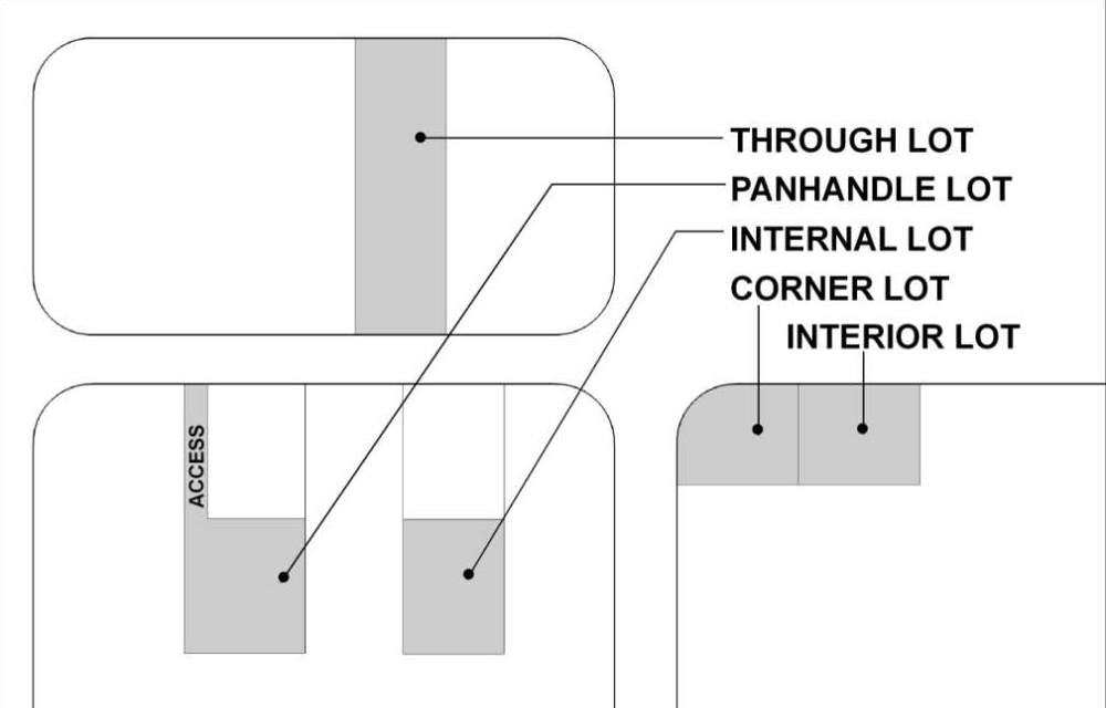
Figure: LOT TYPES
(Ord. 15-1018 § 1)
15.110.030 Designation of Lot Lines
The property lines that establish the boundaries of buildable lots shall be designated as follows:
A. Front Lot Lines.
|
Lot Type |
|
|---|---|
|
Interior Lot |
The boundary that abuts the public or private street. |
|
Corner Lot |
Those boundaries that abut a public or private street. If a lot abuts three (3) or more public or private streets, the lot shall have a front lot line only on the two (2) public or private streets with the highest roadway classifications. If a determination cannot be made as to which of the three (3) public streets have higher classifications, or where there are multiple private streets, the front lot lines shall be determined by the Director, taking into consideration pedestrian and vehicle connectivity and the surrounding pattern of development. |
|
Through Lot |
Those boundaries that abut a public or private street. |
|
Panhandle Lots |
The front lot line shall be determined by the Director taking into consideration pedestrian and vehicle connectivity and the surrounding pattern of development. |
|
Internal Lots |
The front lot line shall be determined by the Director taking into consideration pedestrian and vehicle connectivity and the surrounding pattern of development. |
B. Rear Lot Lines. The line opposite, most distant and most parallel with the front lot line. For irregularly shaped lots, a line ten (10) feet in length within the lot and farthest removed from the front line and at right angles to the line comprising the depth of the lot shall be used as the rear lot line.
C. Side Lot Lines. All lot lines which do not qualify as a rear or front lot line. (Ord. 25-1008 § 1 (Exh. A); Ord. 24-1022 § 5 (Exh. C); Ord. 15-1018 § 1)
15.110.040 Yard Setbacks
A. To determine yard setbacks, lot lines shall be measured from the existing edge of the street right-of-way.
B. Determining Front, Rear and Side Yard Setbacks.
1. Front Yard. The front yard setback shall be measured from the front lot line as established in SMC 15.110.030(A), Designation of Lot Lines, Front Lot Lines.
2. Rear Yard. The rear yard setback shall be measured from the rear lot line as established in SMC 15.110.030(B), Designation of Lot Lines, Rear Lot Lines.
3. Side Yard. The side yard setback shall be measured from the side lot lines as established in SMC 15.110.030(C), Designation of Lot Lines, Side Lot Lines.
C. Setbacks for Subdivisions and Short Plats with Access Easements.
1. Lots created through subdivisions and short plats shall maintain required front, side and rear setbacks from any access easement, except as follows: short plats of only two (2) lots shall not be required to meet the side yard setbacks from approved access easements. (Ord. 21-1008 § 6; Ord. 15-1018 § 1)
15.110.050 Lot Area
A. Lot area shall be the total horizontal land area contained within the boundaries of a lot, calculated pursuant to SMC 15.105.120, “Lot Area,” and subsection (B) of this section, Short Plats.
B. Short Plats. In determining the lot area of new lots in short plats proposed under SMC Title 14, the area of the original lot area, including any area to be dedicated for public right-of-way, may be used in the calculation in the number of lots that may be segregated from the original lot. (Ord. 15-1018 § 1)
15.110.060 Lot Width
A. Rectangular Lots. For rectangular lots, width shall be determined by the distance between the two (2) established side lot lines.
B. Irregular Lots. For irregularly shaped lots, lot width shall be determined by the diameter of a circle that fits within the established lot lines. The diameter of the circle shall not exceed that stipulated in the standards chart. The topography of the lot where the circle is located shall not have an average slope exceeding twenty-five percent (25%) nor contain unbuildable, sensitive areas.
Figure: LOT WIDTH DETERMINATION
(Ord. 15-1018 § 1)
15.110.070 Structure Height
A. Primary Structures.
1. The height of a primary structure is measured from the established ground elevation (finished foundation) to:
a. The highest point of the coping of a flat roof;
b. The deck line of a mansard roof; or
c. The midpoint of a gable, shed, or hipped roof.
2. For primary structures on sloped property, the average of the lowest and highest ground elevation shall be considered the finished foundation measurement.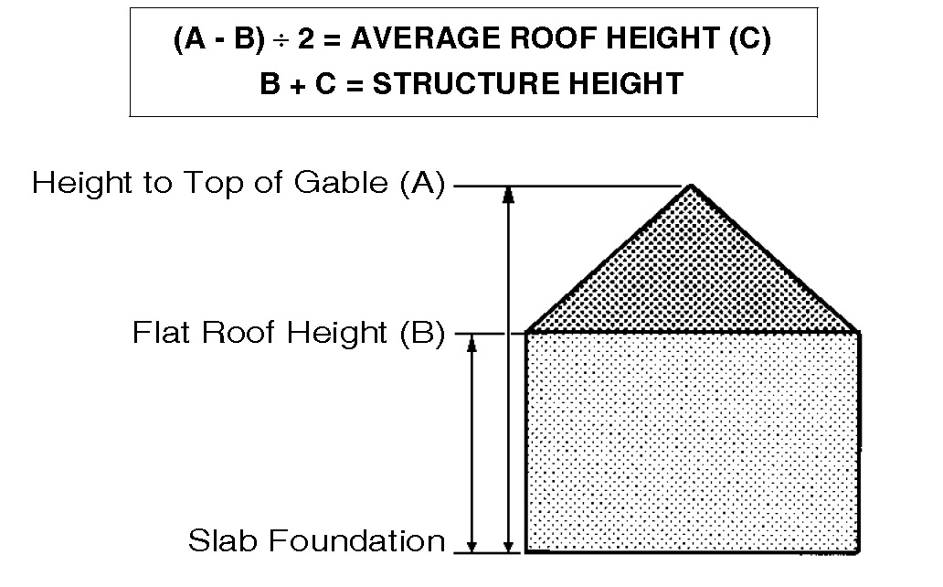
Figure: HEIGHT CALCULATION FOR A PRIMARY STRUCTURE ON LEVEL GROUND
B. Accessory Structures.
1. The height of an accessory structure is measured from the established ground elevation (finished foundation) to the highest point of the roof.
2. For accessory structures on sloped property, the average of the lowest and highest ground elevation shall be considered the finished foundation measurement. (Ord. 15-1018 § 1)
15.110.080 Lot Coverage
A. Lot coverage is that percentage of the lot area covered by all buildings including accessory buildings and uses and tent structures and tent structure canopies as defined under Chapter 15.105 SMC, Definitions, excluding driveway and outside parking areas.
B. Coverage is determined by measuring from a horizontal plane from the building footprint as set forth in the Building Code. (Ord. 15-1018 § 1)