


Chapter 20.80
Critical Areas
Sections:
Subchapter 1. Critical Areas – General Provisions
20.80.020 Relationship to other regulations.
20.80.025 Critical areas maps.
20.80.030 Best available science.
20.80.035 Classification and rating of critical areas.
20.80.045 Critical areas preapplication meeting.
20.80.050 Critical areas notice, tracts, and easements.
20.80.055 Critical area fencing and signs.
20.80.060 Financial guarantee requirements.
20.80.065 Critical area report requirements.
20.80.070 Alteration of critical areas.
20.80.085 Pesticides, herbicides and fertilizers on City-owned property.
20.80.090 Unauthorized critical area alterations.
20.80.095 Mitigation requirements.
20.80.100 Mitigation plan requirements.
Subchapter 2. Geologic Hazard Areas
20.80.210 Geologic hazards – Designation and purpose.
20.80.215 Geologic hazards – Classification.
20.80.220 Geologic hazards – Buffer areas.
20.80.225 Geologic hazards – Critical area report requirements.
20.80.230 Geologic hazards – Alterations.
20.80.235 Geologic hazards – Mitigation.
Subchapter 3. Fish and Wildlife Habitat Conservation Areas
20.80.310 Fish and wildlife habitat – Designation and purpose.
20.80.315 Fish and wildlife habitat – Classification.
20.80.320 Fish and wildlife habitat – Buffer areas and riparian management zone.
20.80.325 Fish and wildlife habitat – Critical area report requirements.
20.80.330 Fish and wildlife habitat – Alterations.
20.80.335 Fish and wildlife habitat – Mitigation.
Subchapter 4. Wetlands
20.80.410 Wetlands – Designation and purpose.
20.80.415 Wetlands – Classification.
20.80.420 Wetlands – Buffer areas.
20.80.425 Wetlands – Critical area report requirements.
20.80.430 Wetlands – Alterations.
20.80.435 Wetlands - Mitigation.
Subchapter 5. Flood Hazard Areas
20.80.510 Flood hazard – Designation and purpose.
20.80.515 Flood hazard – Classification.
20.80.520 Flood hazard – Alterations.
Subchapter 6. Aquifer Recharge Areas
20.80.610 Aquifer recharge – Designation and purpose.
20.80.615 Aquifer recharge – Classification.
20.80.620 Aquifer recharge – Alterations.
Prior legislation: Ords. 299, 352, 406, 515 and 731.
Subchapter 1.
Critical Areas – General Provisions
20.80.010 Purpose.
A. The purpose of this chapter is to establish supplemental standards for the protection of critical areas, as defined in SMC 20.20.014, in compliance with the provisions of the Washington Growth Management Act of 1990 (Chapter 36.70A RCW) and consistent with the goals and policies of the Shoreline Comprehensive Plan in accordance with the procedures of Chapter 20.30 SMC.
B. By identifying and regulating development and alterations to critical areas and their buffers, it is the purpose of this chapter to:
1. Protect the public from injury, loss of life, property damage or financial losses due to flooding, erosion, landslide, seismic events, or soils subsidence;
2. Protect unique, fragile and valuable elements of the environment;
3. Reduce cumulative adverse environmental impacts to water quality, wetlands, streams, and other aquatic resources, fish and wildlife habitat, landslide hazards, and other geologically unstable features and protect the functions and values of critical areas from overall net loss;
4. Ensure the long-term protection of ground and surface water quality;
5. Alert members of the public, including appraisers, assessors, owners, potential buyers, or lessees, to the development limitations of critical areas and their required buffers;
6. Serve as a basis for exercise of the City’s substantive authority under the State Environmental Policy Act (SEPA) and the City’s Environmental Procedures (Chapter 20.30 SMC, Subchapter 8); and comply with the requirements of the Growth Management Act (Chapter 36.70A RCW) and its implementing rules;
7. Establish standards and procedures that are intended to protect critical areas while accommodating the rights of property owners to use their property in a reasonable manner; and
8. Provide for the management of critical areas to maintain their functions and values and to restore degraded ecosystems.
C. This chapter is to be administered with flexibility and attention to site-specific characteristics. It is not the intent of this chapter to make a parcel of property unusable by denying its owner reasonable economic use of the property or to prevent the provision of public facilities and services necessary to support existing development and planned for by the community without decreasing current service levels below minimum standards. (Ord. 1045 § 1 (Exh. A), 2025; Ord. 856 § 3 (Exh. C), 2019; Ord. 723 § 1 (Exh. A), 2015; Ord. 641 § 5 (Exh. A), 2012; Ord. 398 § 1, 2006; Ord. 324 § 1, 2003; Ord. 238 Ch. VIII § 1(A), 2000).
20.80.015 Applicability.
A. Unless explicitly exempted, the provisions of this chapter shall apply to all land uses, development activity, and all structures and facilities within the City, whether or not a permit or authorization is required, that are within the maximum buffer distance for each critical area type, even if the critical area is on adjacent property. All persons within the City shall comply with the requirements of this chapter.
B. The City shall not approve any permit or otherwise issue any authorization to alter the condition of any land, water, or vegetation or to construct or alter any structure or improvement without first assuring compliance with the requirements of this chapter.
C. Approval of a permit or development proposal pursuant to the provisions of this chapter does not discharge the obligation of the applicant to comply with the provisions of this chapter.
D. The provisions of this chapter shall apply to any forest practices over which the City has jurisdiction pursuant to Chapter 76.09 RCW and WAC Title 222. (Ord. 1045 § 1 (Exh. A), 2025; Ord. 723 § 1 (Exh. A), 2015).
20.80.020 Relationship to other regulations.
A. These critical area regulations shall apply as an overlay in addition to zoning, land use, and other regulations established by the City. In the event of any conflict between these regulations and any other regulations of the City, the regulations which provide greater protection to the critical areas shall apply.
B. Areas characterized by particular critical areas may also be subject to other regulations established by this chapter due to the overlap or multiple functions of some critical areas. In the event of any conflict between regulations for particular critical areas in this chapter, the regulations which provide greater protection to critical areas shall apply.
C. These critical areas regulations shall apply concurrently with review conducted under the State Environmental Policy Act (SEPA), as necessary and locally adopted. Any conditions required pursuant to this chapter shall be included in the SEPA review and threshold determination.
D. Compliance with the provisions of this chapter does not constitute compliance with other Federal, State, and local regulations and permit requirements that may be required (for example, shoreline substantial development permits, Hydraulic Permit Act (HPA) permits, Section 106 of the National Historic Preservation Act, U.S. Army Corps of Engineers Section 404 permits, National Pollution Discharge Elimination System permits). The applicant is responsible for complying with these requirements, apart from the process established in this chapter.
E. The Shoreline Master Program, in Chapter 20.240 SMC, shall establish the standards for critical areas within the shoreline jurisdiction. If there are conflicts or unclear distinctions between the Master Program and the City’s critical areas regulations, the most restrictive requirements apply as determined by the City. (Ord. 1045 § 1 (Exh. A), 2025; Ord. 723 § 1 (Exh. A), 2015).
20.80.025 Critical areas maps.
A. The approximate location and extent of identified critical areas within the City’s planning area are shown on the critical areas maps adopted as part of this chapter. These maps shall be used for informational purposes as a general guide only for the assistance of property owners and other interested parties. Boundaries and locations indicated on the maps are generalized. Critical areas and their buffers may occur within the City, which have not previously been mapped.
B. The critical areas maps and resources cited in the section are to be used as a guide and may be continuously updated as new critical areas are identified. The actual presence or absence, delineation and classification of critical areas shall be identified in the field by a qualified professional, and confirmed by the City. In the event of any conflict between the critical area location or designation shown on the City’s maps and the criteria or standards of this chapter, the criteria and standards shall prevail.
C. The approximate location and extent of critical areas are shown on City of Shoreline data layers maintained in the City of Shoreline geographic information system (GIS). The critical areas maps shall be periodically updated by the City and shall reflect any permit activity, results of special studies and reports reviewed and approved by the City, amendments to the Comprehensive Plan Natural Environment Element, and Department-identified errors and corrections. In addition, the following maps and resources providing information on the location and extent of critical areas are hereby adopted by reference as amended:
1. Geologic Hazards.
a. Washington Department of Ecology coastal zone atlas (for marine bluffs);
b. U.S. Geological Survey geologic maps, landslide hazard maps, and seismic hazard maps;
c. Washington State Department of Natural Resources seismic hazard maps for Western Washington, including, but not limited to, the Liquefaction Susceptibility and Site Class Maps of Western Washington State by County;
d. Washington State Department of Natural Resources slope stability maps;
e. Soils maps produced by the U.S. Department of Agriculture, National Resources Conservation Service; and
f. Washington State Department of Natural Resources Washington Geologic Information Portal.
2. Fish and Wildlife Habitat Conservation Areas.
a. Washington Department of Fish and Wildlife Priority Habitat and Species maps;
b. Washington State Department of Natural Resources Official Water Type Reference maps;
c. Washington State Department of Natural Resources Puget Sound Intertidal Habitat Inventory maps;
d. Washington State Department of Natural Resources Shorezone Inventory;
e. Washington State Department of Natural Resources Natural Heritage Program mapping data;
f. Washington State Department of Health Annual Inventory of Shellfish Harvest Areas;
g. Anadromous and resident salmonid distribution maps contained in the Statewide Washington Integrated Fish Distribution Map published by Washington Department of Fish and Wildlife;
h. Washington State Department of Natural Resources State Natural Area Preserves and Natural Resource Conservation Area maps; and
i. Washington Department of Ecology Coastal Atlas.
3. Wetlands.
a. City of Shoreline, Basin Characterization Reports and Stream and Wetland Inventory and Assessment, Tetra Tech (May 2004);
b. City of Shoreline stormwater basin plans as completed and updated;
c. Soils maps produced by the U.S. Department of Agriculture, National Resources Conservation Service; and
d. The National Wetlands Inventory, produced by the U.S. Fish and Wildlife Service.
4. Flood Hazard Areas.
a. Flood hazard areas shall be designated and classified pursuant to the requirements of the floodplain management regulations, Chapter 13.12 SMC.
5. Critical Aquifer Recharge Areas.
a. At the time of adoption of the updated critical areas regulations, Ordinance 1045, there were no identified critical aquifer recharge areas within the City of Shoreline. (Ord. 1045 § 1 (Exh. A), 2025; Ord. 789 § 1 (Exh. A), 2018; Ord. 723 § 1 (Exh. A), 2015; Ord. 398 § 1, 2006; Ord. 324 § 1, 2003; Ord. 238 Ch. VIII § 1(D), 2000. Formerly 20.80.020.).
20.80.030 Best available science.
The best available science is scientific information, obtained through a valid scientific process, that is applicable to the critical area prepared by local, State, or Federal natural resource agencies, a qualified professional, or team of qualified professionals that is consistent with criteria established in WAC 365-195-900 through 365-195-925 and RCW 36.70A.172.
A. Protect Functions and Values of Critical Areas with Special Consideration to Anadromous Fish. Critical area reports and decisions to alter critical areas shall rely on the best available science to protect the functions and values of critical areas and must give special consideration to conservation or protection measures necessary to preserve or enhance anadromous fish, such as salmon and bull trout, and their habitat, where applicable.
B. Characteristics of a Valid Scientific Process. In the context of critical areas protection, a valid scientific process is one that produces reliable information useful in understanding the consequences of a local government’s regulatory decisions, and in developing critical areas policies and development regulations that will be effective in protecting the functions and values of critical areas. To determine whether information received during the permit review process is reliable scientific information, the Director shall determine whether the source of the information displays the characteristics of a valid scientific process. Such characteristics are as follows:
1. Peer Review. The information has been critically reviewed by other persons who are qualified scientific experts in that scientific discipline. The proponents of the information have addressed the criticism of the peer reviewers. Publication in a referenced scientific journal usually indicates that the information has been appropriately peer-reviewed;
2. Methods. The methods used to obtain the information are clearly stated and reproducible. The methods are standardized in the pertinent scientific discipline or, if not, the methods have been appropriately peer-reviewed to ensure their reliability and validity;
3. Logical Conclusions and Reasonable Inferences. The conclusions presented are based on reasonable assumptions supported by other studies and consistent with the general theory underlying the assumptions. The conclusions are logically and reasonably derived from the assumptions and supported by the data presented. Any gaps in information and inconsistencies with other pertinent scientific information are adequately explained;
4. Quantitative Analysis. The data have been analyzed using appropriate statistical or quantitative methods;
5. Context. The information is placed in proper context. The assumptions, analytical techniques, data, and conclusions are appropriately framed with respect to the prevailing body of pertinent scientific knowledge; and
6. References. The assumptions, analytical techniques, and conclusions are well-referenced with citations to relevant, credible literature, and other pertinent existing information.
C. Nonscientific Information. Nonscientific information, such as anecdotal observations, non-expert opinion, and hearsay, may supplement scientific information, but it is not an adequate substitute for valid and available scientific information.
D. Absence of Valid Scientific Information. Where there is an absence of valid scientific information or incomplete scientific information relating to a critical area, leading to uncertainty about the risk to critical area function, for permitting an alteration of or impact to the critical area, the Director shall:
1. Take a “precautionary or a no-risk approach,” that strictly limits development and land use activities until the uncertainty is sufficiently resolved; and
2. Require application of an effective adaptive management program that relies on scientific methods to evaluate how well regulatory and nonregulatory actions protect the critical area. An adaptive management program is a formal and deliberate scientific approach to taking action and obtaining information in the face of uncertainty. An adaptive management program shall:
a. Address funding for the research component of the adaptive management program;
b. Change course based on the results and interpretation of new information that resolves uncertainties; and
c. Commit to the appropriate time frame and scale necessary to reliably evaluate regulatory and nonregulatory actions affecting protection of critical areas and anadromous fisheries. (Ord. 1045 § 1 (Exh. A), 2025; Ord. 723 § 1 (Exh. A), 2015. Formerly 20.80.060).
20.80.035 Classification and rating of critical areas.
To promote consistent application of the standards and requirements of this chapter, critical areas within the City shall be rated or classified according to their characteristics, function and value, and/or their sensitivity to disturbance. Classification of critical areas shall be determined by the City using the following tools:
A. Application of the criteria contained in these regulations;
B. Consideration of the critical area reports submitted by qualified professionals in connection with applications subject to these regulations; and
C. Review of maps adopted pursuant to this chapter. (Ord. 1045 § 1 (Exh. A), 2025; Ord. 723 § 1 (Exh. A), 2015. Formerly 20.80.070).
20.80.040 Buffer areas.
The establishment of buffer areas shall be required for all development proposals and activities in or adjacent to critical areas. In all cases the standard buffer shall apply unless the Director determines that additional buffer width is necessary or reduced buffer is sufficient to protect the functions and values consistent with the provisions of this chapter and the recommendations of a qualified professional. The purpose of the buffer shall be to protect the integrity, function, value and resource of the subject critical area, and/or to protect life, property and resources from risks associated with development on unstable or critical lands and consists of an undisturbed area of native vegetation. Buffers shall be protected during construction by placement of a temporary barricade if determined necessary by the City, on-site notice for construction crews of the presence of the critical area, and implementation of appropriate erosion and sedimentation controls. Restrictive covenants or conservation easements may be required to preserve and protect buffer areas. (Ord. 1045 § 1 (Exh. A), 2025; Ord. 789 § 1 (Exh. A), 2018; Ord. 723 § 1 (Exh. A), 2015; Ord. 398 § 1, 2006; Ord. 324 § 1, 2003; Ord. 238 Ch. VIII § 2(C), 2000. Formerly 20.80.090.).
20.80.045 Critical areas preapplication meeting.
A. A preapplication meeting, pursuant to SMC 20.30.080, is encouraged but not required prior to submitting an application for development or use of land or prior to starting a development activity or use of the land that may impact critical areas or buffers.
B. A determination may be provided through the preapplication meeting regarding whether critical area reports are required, and if so what level of detail and what elements may be necessary for the proposed project. An applicant may submit a critical area delineation and classification study prior to the City determining that a full critical area report is required.
This determination does not preclude the Director from requiring additional critical area report information during the review of the project. After a site visit and review of available information for the preapplication meeting, the Director may determine:
1. No Critical Areas Present. If the Director’s analysis indicates that the project area is not within or adjacent to a critical area or buffer and that the proposed activity is unlikely to degrade the functions or values of a critical area, then the Director shall determine that the critical area review is complete and note in the preapplication meeting summary letter the reasons that no further review is required.
2. Critical Areas Present, But No Impact. If the Director determines that there are critical areas within or adjacent to the project area, but that the best available science shows that the proposed activity is unlikely to degrade the functions or values of the critical area, the Director may waive the requirement for a critical area report. A waiver may be granted if there is substantial evidence that all of the following requirements will be met:
a. There will be no alteration of the critical area or buffer;
b. The development proposal will not impact the critical area in a manner contrary to the purpose, intent, and requirements of this chapter; and
c. The proposal is consistent with other applicable regulations and standards.
A summary of this analysis and the findings shall be included in the preapplication meeting summary letter and any staff report or decision on the underlying permit.
3. Critical Areas May Be Affected by Proposal. If the Director determines that a critical area or areas may be affected by the proposal, then the Director shall notify the applicant that a critical area report(s) must be submitted prior to further review of the project, and indicate each of the critical area types that should be addressed in the report. (Ord. 1045 § 1 (Exh. A), 2025; Ord. 1027 § 1 (Exh. A), 2025; Ord. 789 § 1 (Exh. A), 2018; Ord. 723 § 1 (Exh. A), 2015).
20.80.050 Critical areas notice, tracts, and easements.
A critical area notice to title is required, as a condition of permit issuance or project approval, when a permit or development application is submitted for development on any property containing a critical area or buffer. The purpose is to inform subsequent purchasers of real property of the existence of critical areas. This requirement can be met through recording of a notice to title prepared by the City, establishment of a critical area tract, or recording of native growth protection area easement consistent with the following provisions:
A. Notice to Title. A notice to title is required when a permit is required for development on any property containing a critical area or buffer. The notice to title applicable to the property shall be approved by the Director and City Attorney for compliance with this provision and be filed by the property owner, at their expense, with the King County Recorder’s Office. The title holder will have the right to challenge this notice and to have it extinguished if the critical area designation no longer applies. However, the titleholder shall be responsible for completing a critical area report, subject to approval by the Director, before the notice on title can be extinguished. The notice shall state that critical areas or buffers have been identified on the property and that limitations on actions in or affecting the critical area or buffer may exist. The notice shall run with the land.
B. Critical Area Tract. Subdivisions, short subdivisions, and binding site plans shall establish a separate critical areas tract as a permanent protective measure for wetlands, fish and wildlife habitat conservation areas, and landslide hazard areas and their buffers. The plat or binding site plan for the project shall clearly depict the critical areas tract, and shall include all of the subject critical area, any required buffer, and any additional lands included voluntarily by the developer. Restrictions to development within the critical area tract shall be clearly noted on the plat or plan. Restrictions shall be consistent with this chapter for the entire critical area tract.
C. Native Growth Protection Area. Unless otherwise required in this chapter, native growth protection area (NGPA) easements shall be recorded on title for all affected parcels prior to approval of a development agreement, issuance of a master development plan permit, or issuance of a site development or building permit, when two or more dwelling units and/or nonresidential development are proposed on one parcel, to delineate and protect those contiguous wetlands, fish and wildlife habitat conservation, and landslide hazard critical areas and their buffers. The easement to be recorded shall clearly depict the critical area and the limits of the NGPA easement and shall include all of the subject critical area(s) and any required buffer(s). Restrictions to development within the NGPA easement shall be clearly noted in the easement and shall include the following:
1. That native vegetation will be preserved for the purpose of preventing harm to property and the environment, including, but not limited to, controlling surface water runoff and erosion, limiting chemical applications of hazardous substances (pesticides, herbicides, fertilizers), maintaining slope stability, buffering, and protecting plants, fish, and animal habitat; and
2. The right of the City to enforce the terms of the restriction.
D. Modifications and Waivers. Where the standards in this chapter allow for development within the identified critical areas, the Director may modify the language or dimensions of the required critical area tract or native growth protection area easement for consistency with the extent of the development to be permitted.
E. Proof of Notice. The applicant shall submit proof that the notice has been recorded on title before the City approves any development permit, including master development plan permits, for the property or, in the case of subdivisions, short subdivisions, binding site plans, or development agreements, at or before recording. (Ord. 1045 § 1 (Exh. A), 2025; Ord. 723 § 1 (Exh. A), 2015. Formerly 20.80.100).
20.80.055 Critical area fencing and signs.
A. Temporary Fencing. The outer perimeter of the critical area or buffer and the clearing limits identified by an approved permit or authorization shall be marked in the field with temporary “clearing limits” fencing in such a way as to ensure that no unauthorized intrusion will occur. The fencing is subject to inspection by the Director prior to the commencement of permitted activities during the preconstruction meeting required under SMC 20.50.330(E). This temporary fencing shall be maintained throughout construction and shall not be removed until permanent signs, if required, are in place.
B. Permanent Fencing. Fencing installed as part of a proposed activity or as required in this subsection shall be designed so as to not interfere with species migration, including fish runs, and shall be constructed in a manner that minimizes habitat impacts. Permanent fencing shall be required at the outer edge of a critical area or buffer under the following circumstances; provided, that the Director may waive this requirement:
1. As part of any development proposal for subdivisions, short plats, multifamily, mixed use, and commercial development where the Director determines that such fencing is necessary to protect the functions and values of or reduce hazards from the critical area; provided that breaks in permanent fencing may be allowed for access to allowed uses;
2. As part of development proposals for parks where the adjacent proposed use is active recreation and the Director determines that such fencing is necessary to protect the functions of the critical area;
3. When averaging or reductions to wetland buffers or riparian management zones are part of a development proposal;
4. At the Director’s discretion to protect the values and functions of or reduce hazards from a critical area as demonstrated in a critical area report. If found to be necessary, the Director shall condition any permit or authorization issued pursuant to this chapter to require the applicant to install a permanent fence at the edge of the critical area or buffer, when fencing will prevent future impacts to the critical area or buffer or reduce hazards from the critical area;
5. The applicant shall be required to install a permanent fence around the critical area buffer or riparian management zone when domestic grazing animals, only as allowed under SMC 20.40.240, are present or may be introduced on site.
C. Permanent Signs. As a condition of any permit or authorization issued pursuant to this chapter, the Director may require the applicant to install permanent signs along the boundary of a critical area or buffer, when recommended in a critical area report or otherwise required by the provisions of this chapter.
1. Signs shall be required for critical areas tracts, easements and dedications, provided the Director may waive this requirement.
2. Permanent signs shall be made of an enamel-coated metal face and attached to a metal post or another nontreated material of equal durability. Signs must be posted at an interval of one per lot or every 50 feet, whichever is less, or with alternative spacing approved by the Director and must be maintained by the property owner in perpetuity.
3. The sign shall include the following text, or with alternative text approved by the Director:
City of Shoreline Designated Critical Area. Activities, including clearing and grading, removal of vegetation, pruning, cutting of trees or shrubs, planting of nonnative species, and other alterations may be prohibited. Help protect and care for this area. Please contact the City of Shoreline with questions or concerns.
(Ord. 1045 § 1 (Exh. A), 2025; Ord. 723 § 1 (Exh. A), 2015. Formerly 20.80.110).
20.80.056 Voluntary critical area restoration projects.
Repealed by Ord. 1045. (Ord. 723 § 1 (Exh. A), 2015).
20.80.060 Financial guarantee requirements.
Bonds, and other financial guarantees, and associated performance agreements or maintenance/defect/monitoring agreements shall be required for projects with required mitigation or restoration of impacts to critical areas or critical area buffers; provided, the Director may waive or modify these requirements. Financial guarantees and agreements shall be consistent with the following:
A. A performance agreement and acceptable financial guarantee are required when mitigation pursuant to a development proposal is not completed prior to final permit approval, such as final plat approval or final building inspection. The amount of the performance bond(s) shall equal 125 percent of the cost of the mitigation project.
B. A performance agreement and acceptable financial guarantee are required from the applicant when restoration is required for remediation of a critical area violation under SMC 20.80.090. The amount of the financial guarantee shall equal 125 percent of the cost of the mitigation project.
C. A maintenance/defect/monitoring agreement and acceptable financial guarantee are required to ensure the applicant’s compliance with the conditions of the approved mitigation plan pursuant to a development proposal or restoration plan for remediation of a violation. The amount of the maintenance bond(s) shall equal 25 percent of the cost of the mitigation project in addition to the cost for monitoring for a minimum of five years. The monitoring portion of the financial guarantee may be reduced in proportion to work successfully completed over the period of the bond. The bonding period shall coincide with the monitoring period. (Ord. 1045 § 1 (Exh. A), 2025; Ord. 723 § 1 (Exh. A), 2015. Formerly 20.80.120).
20.80.065 Critical area report requirements.
A. Report Required. If uses, activities, or developments are proposed within, adjacent to, or are likely to impact critical areas or their buffers, an applicant shall provide site-specific information and analysis in the form of critical area report(s) as required in this chapter. Critical area reports are required in order to identify the presence, extent, and classification/rating of potential critical areas, as well as to analyze, assess, and mitigate the potential adverse impact to or risk from critical areas for a development project. Critical area reports shall use standards for best available science in SMC 20.80.030. Critical area reports for two or more types of critical areas must meet the report requirements for each type of critical area. The expense of preparing the critical area report(s) shall be borne by the applicant. This provision is not intended to expand or limit an applicant’s other obligations under WAC 197-11-100.
B. Preparation by Qualified Professional. Critical area report(s) shall be prepared, signed, and stamped (if applicable), by qualified professional(s) as defined in SMC 20.20.042, with the required training and experience specific to the type(s) of critical area(s) present consistent with the requirements of SMC 20.80.225, 20.80.325, and 20.80.425.
C. Third Party Review of Critical Area Reports. Review of required critical area reports by a qualified professional under contract with or employed by the City will be required by the Director at the applicant’s expense when the Director determines such services are necessary to demonstrate compliance with the standards and guidelines of this chapter.
D. Minimum Report Contents. At a minimum, critical area reports shall contain the following:
1. The name and contact information of the applicant;
2. Proposal description, address and parcel number(s) with a vicinity map;
3. The names and qualifications of the qualified professional(s) preparing the report. Proof of licensing, credentials, and/or resume of the qualified professional(s) preparing the report must be attached to the report for review by the City to determine if the minimum qualifications in SMC 20.20.042 are met;
4. Identification and assessment of any temporary or permanent impacts to critical area(s) or buffers including square footage or acreage estimates of impacted areas;
5. A schedule of anticipated timing of work and recommendations for timing of work that minimizes potential impacts or hazards;
6. Documentation of any fieldwork performed on the site related to delineating, typing, classifying or rating a critical area including dates of fieldwork and names of professionals conducting the fieldwork for the specific critical area;
7. Identification and characterization of all critical areas and buffers on the subject property, and any off-site critical areas and buffers within 300 feet of the subject property;
8. A scaled copy of the site plan for the development proposal meeting the standards set by the Director;
9. A stormwater pollution prevention plan in compliance with the requirements of Chapter 13.10 SMC shall either be included in the critical area report or be referenced if it is prepared separately;
10. A statement specifying the accuracy of the report and all assumptions made and relied upon;
11. A description of the methodologies used to conduct the critical areas investigation, including references;
12. A description of reasonable efforts made to apply mitigation sequencing pursuant to SMC 20.80.095; and
13. Plans for mitigation required to compensate for any critical areas impacts, in accordance with SMC 20.80.100, Mitigation plan requirements.
E. Existing Reports. Unless otherwise provided, a critical areas report may incorporate, be supplemented by, or composed of any reports or studies required by other laws and regulations or previously prepared for and applicable to the development proposal site, as approved by the Director. At the discretion of the Director, reports previously compiled or submitted as part of a proposal for development may be used as a critical areas report to the extent that the requirements of this section and the report requirements for each specific critical area type are met. Critical areas reports shall be considered valid for five years; after such date the City shall determine whether a revision or additional assessment is necessary. Supplemental critical area report(s) may be required to provide information and analysis to address changes to the project scope and potential impacts or to changes to applicable regulations that have been made subsequent to existing, valid critical area reports.
F. Modifications to Report Requirements.
1. Limitations to Study Area. The Director may limit the required geographic area of the critical areas report as appropriate if:
a. The applicant, with assistance from the City of Shoreline, cannot obtain permission to access properties adjacent to the project area, in which case the applicant may rely on estimated conditions using the best information available; or
b. The proposed activity will affect only a limited part of the subject site; or
c. Additional limitations deemed appropriate by the Director.
2. Modifications to Required Contents. The applicant may consult with the Director to obtain approval of modifications to the required contents of the report where, in the judgment of a qualified professional, more or less information is required to adequately address the potential critical area impacts and required mitigation.
3. Additional Information Requirements. The Director may require additional information to be included in the critical areas report when determined to be necessary to the review of the proposed activity in accordance with this chapter. Additional information that may be required includes, but is not limited to:
a. Historical data, including original and subsequent mapping, aerial photographs, data compilations and summaries, and available reports and records relating to the site or past operations at the site;
b. A request for consultation with the Washington Department of Fish and Wildlife (DFW), Washington Department of Ecology (Ecology), local Native American Indian tribes, or other appropriate agency;
c. Copies of the joint aquatic resource permit application (JARPA) and related approvals, such as a hydraulic project approval (HPA) from the DFW, when applicable to the project;
d. Detailed surface and subsurface hydrologic features both on and adjacent to the site; and
e. Where impacts are proposed, mitigation plans consistent with the requirements of SMC 20.80.100 and the mitigation performance standards of the applicable critical area. (Ord. 1045 § 1 (Exh. A), 2025; Ord. 789 § 1 (Exh. A), 2018; Ord. 723 § 1 (Exh. A), 2015. Formerly 20.80.080).
20.80.070 Alteration of critical areas.
A. In general, critical areas and their buffers shall be maintained in their existing state including undisturbed, native vegetation to maintain the functions, values, resources, and public health and safety for which they are protected or allowed as the current, developed legally established condition such as graded areas, structures, pavement, gardens and lawns.
B. Alteration of critical areas, including their established buffers, may only be permitted subject to the criteria and standards in this chapter, and compliance with any Federal and/or State permits required.
C. Unless otherwise provided in this chapter, if alteration of the critical area is unavoidable, all adverse impacts to or from critical areas and buffers resulting from a development proposal or alteration shall be mitigated using the best available science in accordance with an approved critical areas report, so as to result in no overall net loss of critical area functions and values and no increased risk of hazards.
D. The Director shall condition approval of alterations, including exempt or allowed activities within critical areas or buffers as necessary to minimize or mitigate any potential adverse impacts. Conditions shall be based on the best available science and may include, but are not limited to:
1. Preservation of vegetation and/or habitat features;
2. Limitations on access, including temporary and/or permanent fencing; and
3. Seasonal restriction of construction activities. (Ord. 1045 § 1 (Exh. A), 2025; Ord. 789 § 1 (Exh. A), 2018; Ord. 723 § 1 (Exh. A), 2015. Formerly 20.80.050).
20.80.075 Exemptions.
Notwithstanding the exemptions provided by this section, any otherwise exempt activities occurring in or near a critical area or critical area buffer should meet the purpose and intent of SMC 20.80.010 and should consider on-site alternatives that avoid or minimize impacts. To be exempt from this chapter does not give permission to degrade a critical area or ignore risk from natural hazards. Exempt activities shall result in no net loss of critical areas functions and values or increase in hazards. Any incidental damage to, or alteration of, a critical area that is not a necessary outcome of the exempted activity shall be restored, rehabilitated, or replaced at the responsible party’s expense. The following activities shall be exempt from the provisions of this chapter, but are not exempt from applicable permits:
A. Emergencies. Alterations in response to emergencies which threaten the public health, safety and welfare or which pose an imminent risk of damage to private property:
1. Alterations shall be reported to the City no later than 30 days after the alteration;
2. Only the minimum intervention necessary to reduce the risk to public health, safety, or welfare and/or the imminent risk of damage to private property shall be authorized by this exemption;
3. The City may require a permit be obtained after the fact and require the critical area and buffer be restored consistent with a critical area report and mitigation plan;
4. If the Director determines that the action taken, or any part of the action taken, was beyond the scope of an allowed emergency action, then enforcement provisions of SMC 20.80.090, Unauthorized critical area alterations, shall apply.
B. Utilities. For the purposes of this exemption utilities includes all public and private structures and conveyance systems and their associated facilities including, but not limited to: service lines, pipes, mains, pumps, poles, equipment and appurtenances – both above and below ground. Activities must be undertaken pursuant to City-approved best management practices, and best available science regarding protection of critical areas. Measures to avoid and minimize impacts shall be documented. Revegetation of disturbed areas is required to be native vegetation, unless the existing, nonnative vegetation is reestablished with no change to type or extent. Exempt utilities work includes:
1. Normal and routine operation, maintenance, replacement, and repair of existing utilities. This provision does not include expansion of existing utilities;
2. Relocation of existing utilities only when required by the City, which approves the new location of the facilities. This provision does not include electrical substations;
3 Installation, expansion, or construction of new utilities within existing improved rights-of-way, existing legally improved private roadways, or utility corridors. This provision does not include electrical substations.
C. Roadways and Driveways. Maintenance, operation, repair, modification, or replacement of publicly improved roadways or City-authorized private roadways, driveways, and associated stormwater drainage systems; as long as any such alteration does not involve the expansion of roadways or related improvements into previously unimproved rights-of-way, portions of rights-of-way, or private property and does not alter a wetland or watercourse, such as culverts or bridges, or result in the transport of sediment or increased stormwater. Retention and replanting of native vegetation shall occur wherever possible along the right-of-way improvement and resulting disturbance;
D. Recreation Facilities.
1. Maintenance, operation, repair, modification, or replacement of existing recreation facilities as long as any such activity does not involve the expansion of facilities and existing improvements into a previously unimproved portion of critical areas or required buffers. Retention and replanting of native vegetation shall occur wherever possible in areas of land disturbance.
2. Construction of new passive recreation facilities including but not limited to nonmotorized walkways and trails, footbridges, wildlife viewing structures or platforms, benches, informational or educational signs, and other similar facilities meeting the following requirements:
a. Walkways, trails and footbridges shall be no more than five feet in width and are limited to the least impactful pervious surfaces, with preference for natural materials. Raised boardwalks utilizing nontreated pilings may be acceptable;
b. Placement of any facilities shall be located to retain significant trees;
c. Informational signs or educational demonstration facilities are limited to no more than one square yard of surface area and four feet in height;
d. An on-site area equal in size to the disturbed area shall be vegetated with site-appropriate native plantings at natural densities;
e. New facilities shall be located only in the outer 25 percent of the buffer or riparian management zone; and
f. New passive recreation facilities that do not meet the above criteria shall be allowed without a critical areas reasonable use or special use permit but shall require submittal of a critical areas report and mitigation plan.
E. Minor Conservation and Enhancement. Minor conservation and enhancement of critical areas and buffers not associated with mitigation that does not alter the location, nor reduce the dimensions or size of the critical area or buffer, and results in improvement of the critical area functions and values consistent with the following:
1. Eligible activities include:
a. Removal of noxious weeds or invasive vegetation as identified by the Washington State or King County Noxious Weed Control Board;
b. The planting of native plants;
c. Ongoing vegetation management consistent with a previously approved critical area mitigation, restoration, remediation, or enhancement plan.
d. Other conservation and enhancement activities as approved by the Director.
2. The area of work is not in a very high risk landslide hazard area, unless it is within the inner critical root zone of a tree;
3. All work is performed above the ordinary high-water mark and above the top of a stream bank;
4. Work shall be undertaken with hand labor, including handheld mechanical tools:
a. When prescribed by the King County Noxious Weed Control Board, the use of riding mowers, light mechanical cultivating equipment, herbicides, or biological control methods may be allowed only with permit and approval by the City on private property or when performed in accordance with SMC 20.80.085, Pesticides, herbicides and fertilizers on City-owned property.
5. Plants that appear on the Washington State or King County Noxious Weed Control Board lists must be handled and disposed of in accordance with the best management practices appropriate to that species and approved by the City when permit review is applicable;
6. Replanting with site-appropriate native species at natural densities shall take place immediately following any removal activities;
7. For projects on private property that will clear greater than 500 square feet of a critical area or buffer in a calendar year, the following must be submitted to the city for review as part of a clearing and grading permit:
a. A planting plan including:
i. The area of work;
ii. Method of removal of existing vegetation;
iii. A detailed native planting plan with a plant list and planting density;
iv. A schedule for commencement and completion of the project.
b. A stormwater pollution prevention plan.
F. Active Hazard Trees. Removal of active or imminent hazardous trees in accordance with SMC 20.50.310(A)(1);
G. Nonimminent Hazard Trees. Removal of not active or imminent hazardous trees in accordance with the following:
1. For hazardous circumstances that are not active or imminent, such as suspected tree rot or diseased trees or less obvious structural wind damage to limbs or trunks, a permit exemption request form must be submitted by the property owner together with a tree evaluation form prepared by a qualified professional arborist as defined in SMC 20.20.042. Both the permit exemption request form and tree evaluation form shall be provided by the Director;
2. The permit exemption request form shall include a grant of permission for the Director and/or qualified professionals under contract with or employed by the City to enter the subject property to evaluate the circumstances. Attached to the permit exemption request form shall be a risk assessment form that documents the hazard and which must be signed by a certified arborist or professional forester;
3. No permit exemption request shall be approved until the Director reviews the submitted forms and conducts a site visit. The Director may require third party review of the request be performed by a qualified professional under contract with or employed by the City at the applicant’s expense, and may require that the subject tree(s) and vegetation be cordoned off with yellow warning tape during the review of the request for exemption;
4. Approval to cut or clear trees may only be given upon recommendation of the qualified professional arborist that the condition constitutes an actual threat to life or property in homes, private yards, buildings, public or private streets and driveways, sidewalks, improved utility corridors, or access for emergency vehicles, and any trail, as proposed by the property owner and approved by the Director for purposes of this section;
5. The Director shall authorize only such alteration to existing trees and vegetation as may be necessary to eliminate the hazard and shall condition authorization on means and methods of removal necessary to minimize environmental impacts, including replacement of any significant trees. The arborist shall include an assessment of whether a portion of the tree suitable for a snag for wildlife habitat may safely be retained. All work shall be done utilizing handheld implements only, unless the property owner requests and the Director approves otherwise in writing. The Director may require that all or a portion of cut materials be left on site;
6. The removed trees shall be replaced within one year consistent with the provisions of SMC 20.50.360. Where nonsignificant trees are approved for removal as hazardous, replacement shall be one tree for each tree removed. Replacement tree(s) shall be planted at a different, nearby location on the same property if it can be determined that the planting in the same location would create a new hazard or potentially damage the critical area; and
7. If a tree to be removed provides priority habitat, such as an eagle perch or occupied nest, a qualified professional shall be consulted, at the applicant’s expense, to determine timing and methods of removal that will minimize and mitigate impacts;
H. Site Investigation. Site investigative work and studies necessary for preparing land use or permit applications, including soils tests, water quality studies, wildlife studies and similar tests and investigations; provided, that any disturbance of the critical area shall be the minimum necessary to carry out the work or studies;
I. Passive Outdoor Activities. Educational activities, scientific research, and outdoor recreational activities, including but not limited to interpretive field trips, bird watching, public beach access including water recreation-related activities, bicycling and hiking;
J. Existing Landscaping. Normal and routine maintenance and operation of existing landscaping, lawns, and gardens including mowing, weeding, planting and pruning of protected trees consistent with SMC 20.50.350(E); provided, that such activities do not expand any further into critical areas or buffers;
K. Chemical Applications. The application of herbicides, pesticides, organic or mineral-derived fertilizers, or other hazardous substances, if necessary; provided, that their use shall be restricted in accordance with State Department of Fish and Wildlife Management recommendations and the regulations of the State Department of Agriculture and the U.S. Environmental Protection Agency;
L. Minor Activities. Minor activities not mentioned above and determined by the City to have minimal impacts to a critical area;
M. Foraging. The harvesting of wild crops in a manner that is not injurious to natural reproduction of such crops and provided the harvesting does not require tilling of soil, planting of crops, chemical applications, or alteration of the fish and wildlife habitat conservation area by changing existing topography, water conditions, or water sources. (Ord. 1045 § 1 (Exh. A), 2025; Ord. 723 § 1 (Exh. A), 2015; Ord. 640 § 1 (Exh. A), 2012; Ord. 398 § 1, 2006; Ord. 324 § 1, 2003; Ord. 238 Ch. VIII § 1(G), 2000. Formerly 20.80.030).
20.80.080 Allowed activities.
A. Critical Area Report. Activities allowed under this section shall have been reviewed and permitted or approved by the City and any other agency with jurisdiction, but do not require submittal of a separate critical area report, unless such submittal was required previously for the underlying permit. The Director may apply conditions to the underlying permit or approval to ensure that the allowed activity is consistent with the provisions of this chapter to protect critical areas.
B. Best Management Practices. All allowed activities shall avoid impacts to critical areas. Where impacts cannot be avoided, allowed activities shall be conducted using the best management practices that result in no net loss of ecological functions or increase in hazards from the critical areas. Best management practices shall be used for tree and vegetation protection, construction management, erosion and sedimentation control, water quality protection, and regulation of chemical applications. The City shall require the use of best management practices to ensure that the activity does not result in degradation to the critical area. Any incidental damage to, or alteration of, a critical area shall be restored, rehabilitated, or replaced at the responsible party’s expense.
C. Allowed Activities. The following activities are allowed:
1. Modifications to Existing Structures Within Critical Areas. Modification of, addition to, maintenance, repair, or replacement of legally nonconforming structures consistent with SMC 20.30.280, which do not meet the building setback or buffer requirements for critical areas if the modification, addition, replacement or related activity does not increase the impact to a critical area or buffer or increase the existing area of hardscape lying within the critical area or buffer.
a. Within landslide hazard areas additions that add height to a nonconforming structure may only be allowed with review of a critical area report demonstrating that no increased risk of the hazard will occur.
b. If such modification, alteration, repair, or replacement requires encroachment into a critical area or a critical area buffer to perform the work, then encroachment may be allowed subject to restoration of the area of encroachment to achieve no loss of ecological functions.
2. Demolition. Demolition of structures located within critical areas or their buffers, excluding demolition of structures necessary to support or stabilize landslide hazard areas. Unless associated development is proposed with the demolition, the demolition site shall either be seeded with appropriate native seed mix or planted with site-appropriate native species at natural densities to deter invasive species encroachment. (Ord. 1045 § 1 (Exh. A), 2025; Ord. 789 § 1 (Exh. A), 2018; Ord. 723 § 1 (Exh. A), 2015; Ord. 398 § 1, 2006; Ord. 324 § 1, 2003; Ord. 238 Ch. VIII § 1(H), 2000. Formerly 20.80.040.).
20.80.085 Pesticides, herbicides and fertilizers on City-owned property.
Pesticides, herbicides and fertilizers which have been identified by State or Federal agencies as harmful to humans, wildlife, or fish shall not be used in a City-owned riparian corridor, shoreline habitat or its buffer, wetland or its buffer, except as allowed by the Director for the following circumstances:
A. When the Director determines that an emergency situation exists where there is a serious threat to public safety, health, or the environment, and that an otherwise prohibited application must be used as a last resort.
B. Compost or fertilizer may be used for native plant revegetation projects in any location.
C. Limited pesticide and herbicide use may be applied pursuant to the King County Noxious Weed Control Board best management practices, specific to the species needing control, when that is determined to be the best method of control for the location. Federal, State, and local regulations of pesticides and water quality must be followed, including requirements for pesticide applicator licensing from the Washington State Department of Agriculture. (Ord. 1045 § 1 (Exh. A), 2025; Ord. 723 § 1 (Exh. A), 2015; Ord. 398 § 1, 2006).
20.80.090 Unauthorized critical area alterations.
A. When a critical area or its buffer has been altered in violation of this chapter, all ongoing development work shall stop and the critical area shall be restored. The City shall have the authority to issue a stop work order to cease all development, and order restoration measures at the owner’s or other responsible party’s expense to remediate the impacts of the violation of the provisions of this chapter.
B. Requirement for Restoration Plan. All development shall remain stopped until a restoration plan is prepared by the responsible party and an approved permit is issued by the City. Such a plan shall be prepared by a qualified professional using the best available science and shall describe how the actions proposed meet the minimum requirements described in subsection C of this section. The Director may, at the responsible party’s expense, seek expert advice, including but not limited to third party review by a qualified professional under contract with or employed by the City, in determining if the plan meets the minimum performance standards for restoration. Submittal, review, and approval of required restoration plans for remediation of violations of this chapter, Critical Areas, shall be completed through a site development permit application process.
C. Minimum Performance Standards for Restoration.
1. For alterations to aquifer recharge areas, wetlands, and fish and wildlife habitat conservation areas, the following minimum performance standards shall be met for the restoration; provided, that if the violator can demonstrate that greater functional and habitat values can be obtained, these standards may be modified:
a. The pre-violation function and values of the affected critical areas and buffers shall be restored, including water quality and habitat functions;
b. The pre-violation soil types and configuration shall be replicated;
c. The critical area and buffers shall be replanted with native vegetation that replicates the vegetation historically, or pre-violation, found on the site in species types, sizes, and densities. The pre-violation functions and values should be replicated at the location of the alteration; and
d. Information demonstrating compliance with the requirements in SMC 20.80.100, Mitigation plan requirements, and the applicable mitigation sections for the affected type(s) of critical area(s) and their buffer(s) shall be submitted to the Director with a complete site development permit application.
2. For alterations to flood hazard and geologic hazard areas, the following minimum performance standards shall be met for the restoration of a critical area; provided, that if the violator can demonstrate that greater safety can be obtained, these standards may be modified:
a. The hazard shall be reduced to a level equal to, or less than, the pre-violation hazard;
b. Any risk of personal injury resulting from the alteration shall be eliminated or minimized; and
c. The hazard area and buffers shall be replanted with native vegetation sufficient to minimize the hazard.
D. Site Investigation. The Director is authorized to take such actions as are necessary to enforce this chapter. The Director shall present proper credentials and obtain permission before entering onto private property.
E. Penalties. Any responsible party violating any of the provisions of this chapter may be subject to any applicable penalties per SMC 20.30.770 plus a per tree penalty in the amount of $3,000 per nonsignificant tree and $9,000 per significant tree, for trees removed from a critical area or critical area buffer in violation of the provisions of this chapter. (Ord. 1045 § 1 (Exh. A), 2025; Ord. 723 § 1 (Exh. A), 2015. Formerly 20.80.130).
20.80.095 Mitigation requirements.
This section applies to mitigation required with all critical areas reviews, approvals, and enforcement pursuant to this chapter. This section is supplemented with specific measures under subchapters for particular critical areas. Mitigation for specific development proposals may include a combination of the measures below and shall be designed and constructed in accordance with the provisions of this section. Mitigation shall be sufficient to maintain or compensate for the impacted functions and values of the critical area and to prevent risk from a hazard posed by a critical area. Mitigation shall not be implemented until after the Director has provided approval. No activity or use shall be allowed that results in a net loss of the functions or values of critical areas.
A. Mitigation Sequencing. Applicants must first demonstrate an inability to avoid or reduce impacts before the use of actions to mitigate potential impacts will be allowed. Before impacting any critical areas, an applicant shall demonstrate that the following actions have been taken in the following sequential order:
1. Avoiding the impact altogether by not taking a certain action or parts of actions including assessment of alternative project design and/or location;
2. Minimizing impacts by limiting the degree or magnitude of the action and its implementation by using appropriate technology or by taking affirmative steps, such as project redesign, relocation, or timing, to avoid or reduce impacts;
3. Rectifying the impact by repairing, rehabilitating, or restoring the affected environment or by restoring or stabilizing the hazard area through natural, engineering, or other methods;
4. Reducing or eliminating the impact over time through preservation and maintenance operations during the life of the action;
5. Compensating for the impact by replacing, enhancing, or providing substitute resources or environments; and/or
6. Monitoring, measuring and reporting the impact to the Director and taking appropriate corrective measures.
B. Type, Location, and Timing of Mitigation. Unless it is demonstrated that a higher level of ecological functioning or greater reduction of hazard risk would result from an alternative approach or as otherwise allowed in this chapter, mitigation for adverse impacts shall be based on best available science and shall be in-kind, on-site, and prior to the activities that will disturb the critical area. Mitigation measures that cannot be implemented prior to the critical area impacts shall be completed immediately following disturbance and prior to use or occupancy of the action or development. Construction of mitigation projects shall be timed to reduce impacts to existing fisheries, wildlife, and flora.
1. The Director may authorize a one-time temporary delay in completing construction or installation of the mitigation when the applicant provides a written explanation from a qualified professional as to the rationale for the delay. An appropriate rationale would include identification of the environmental conditions that could produce a high probability of failure or significant construction difficulties (e.g., project delay lapses past a fisheries window, or installing plants should be delayed until the dormant season to ensure greater survival of installed materials). The delay shall not create or perpetuate hazardous conditions or environmental damage or degradation, and the delay shall not be injurious to the health, safety, or general welfare of the public. The request for the temporary delay must include a written justification that documents the environmental constraints that preclude implementation of the compensatory mitigation plan. The justification must be verified and approved by the City. (Ord. 1045 § 1 (Exh. A), 2025; Ord. 723 § 1 (Exh. A), 2015. Formerly 20.80.053).
20.80.100 Mitigation plan requirements.
When mitigation is required, the applicant shall submit for approval by the City a mitigation plan as part of the critical area report. Mitigation plans must meet the minimum requirements of this section and the applicable mitigation performance standards and requirements for the impacted type(s) of critical area(s) and buffer(s), including but not limited to SMC 20.80.235, 20.80.335, and 20.80.435.
A. Preparation by Qualified Professional. Mitigation plan(s) shall be prepared by qualified professional(s) as defined in SMC 20.20.042, with the required training and experience specific to the type(s) of critical area(s) present consistent with the requirements of SMC 20.80.225, 20.80.325, and 20.80.425.
B. Third Party Review of Mitigation Plans. Review of required mitigation plans by a qualified professional under contract with or employed by the City will be required when deemed necessary by the Director.
C. Minimum Mitigation Plan Contents. Utilizing best available science, the mitigation plan shall include written specifications and descriptions of the mitigation proposed. The written report shall include:
1. Identification of the existing critical areas and buffers functions and/or hazards;
2. A description of the anticipated impacts to the critical areas;
3. The proposed schedule of mitigation sequence, timing, and duration;
4. A description of the mitigating actions proposed;
5. A scaled copy of the site plan for the proposal meeting the standards set by the Director;
6. The purposes of the mitigation measures, including the site selection criteria, and environmental goals and objectives of the mitigation measures related to the functions and values and/or hazards of the impacted critical area;
7. Measurable, specific performance standards for evaluating whether or not the goals of the mitigation project have been attained and the requirements of this chapter have been met; and
8. Cost estimates of labor and materials necessary for the mitigation that will be used by the City to calculate the amounts of financial guarantees to ensure the mitigation plan is fully implemented.
D. Monitoring Program and Contingency Plan. A monitoring program, including a monitoring schedule and measurable success criteria, shall be included in the mitigation plan and implemented by the applicant to determine the success of the mitigation project and any necessary corrective actions. This program shall determine if the original goals and objectives of the mitigation plan are being met.
1. Monitoring reports shall be submitted, consistent with subsection F of this section, to the City on the schedule identified in the monitoring plan, but not less than every other year.
2. Monitoring programs shall be established for a period necessary to establish that performance standards have been met, but not for less than a minimum of five years without approval from the Director.
3. Vegetative success shall, at a minimum, equal 80 percent survival of planted trees and shrubs and 80 percent cover of desirable understory or emergent plant species at the end of the required monitoring period. Alternative standards for vegetative success may be allowed if recommended by a qualified professional.
4. A contingency plan shall be established if the mitigation project is inadequate or fails. Contingency plans include identification of potential courses of action, and any corrective measures to be taken if monitoring or evaluation indicates project performance standards are not being met. Corrective measures will be required by the City when the qualified professional indicates, in a monitoring report, that the contingency actions are needed to ensure project success by the end of the monitoring period.
5. If the mitigation goals are not obtained within the initial monitoring period, the applicant remains responsible for restoration of the impacted values and functions or hazard risk reduction until the mitigation goals agreed to in the mitigation plan are achieved.
E. As-Built Report and Plans. An as-built report and accompanying plans, prepared and signed by the applicant’s qualified professional and meeting the standards set by the Director, is required to be submitted and approved prior to final inspection.
F. Monitoring Reports. Monitoring reports, prepared by a qualified professional, shall be submitted to the City consistent with the approved monitoring plan. Prior to permit issuance the applicant shall pay the cost of a critical areas monitoring inspection fee which covers the review of monitoring reports and critical area monitoring inspections by the City, or a qualified professional retained by the City. Monitoring reports shall, at a minimum, include:
1. Monitoring visit observations, documentation, and analysis of monitoring data collected including wildlife, vegetation, water quality, water flow, stormwater storage and conveyance, and existing or potential degradation, as applicable;
2. Photos from photo points;
3. Determination whether performance standards are being met; and
4. Maintenance and/or contingency action recommendations to ensure success of the project at the end of the monitoring period. (Ord. 1045 § 1 (Exh. A), 2025; Ord. 723 § 1 (Exh. A), 2015. Formerly 20.80.082).
Subchapter 2.
Geologic Hazard Areas
20.80.210 Geologic hazards – Designation and purpose.
A. Geologic hazard areas are those lands that are susceptible to erosion, landsliding, seismic, or other geological events as identified by WAC 365-190-120. These areas may not be suited for development activities because they may pose a threat to public health and safety.
Areas susceptible to one or more of the following types of hazards shall be designated as geologic hazard areas:
1. Landslide hazard;
2. Seismic hazard;
3. Erosion hazard.
B. The primary purpose of geologic hazard area regulations is to avoid and minimize potential impacts to life and property from geologic hazards, conserve soil resources, and minimize structural damage relating to seismic hazards. This purpose shall be accomplished through appropriate levels of study and analysis, application of sound engineering principles, and regulation or limitation of land uses, including maintenance of existing vegetation, regulation of clearing and grading activities, and control of stormwater. (Ord. 1045 § 1 (Exh. A), 2025; Ord. 723 § 1 (Exh. A), 2015; Ord. 398 § 1, 2006; Ord. 238 Ch. VIII § 3(A), 2000).
20.80.215 Geologic hazards – Classification.
Geologic hazard areas shall be classified according to the criteria in this section as follows:
A. Landslide Hazard Areas. Landslide hazard areas are those areas potentially subject to landslide activity based on a combination of geologic, topographic and hydrogeologic factors as classified in subsection B of this section with slopes 15 percent or steeper within a vertical elevation change of at least 10 feet or all areas of prior landslide activity regardless of slope. A slope is delineated by establishing its toe and top, and measuring the inclination over 10 feet of vertical relief (see Figure 20.80.215(A)). The edges of the geologic hazard are identified where the characteristics of the slope cross-section change from one landslide hazard classification to another, or no longer meet any classification. Additionally:
1. The toe of a slope is a distinct topographic break which separates slopes inclined at less than 15 percent from slopes above that are 15 percent or steeper when measured over 10 feet of vertical relief; and
2. The top of a slope is a distinct topographic break which separates slopes inclined at less than 15 percent from slopes below that are 15 percent or steeper when measured over 10 feet of vertical relief.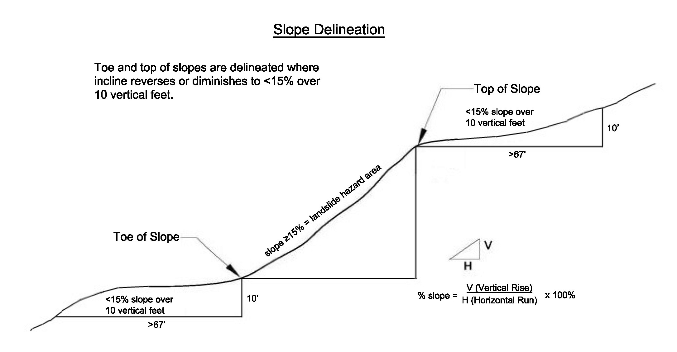
Figure 20.80.215(A): Illustration of Slope Calculation for Determination of Top and Toe of Landslide Hazard Area.
B. Landslide Hazard Area Classification. Landslide hazard areas are classified as follows:
1. Moderate to High Risk.
a. Areas with slopes between 15 percent and 40 percent and that are underlain by soils that consist largely of sand, gravel or glacial till that do not meet the criteria for very high risk areas in subsection (B)(2) of this section;
b. Areas with slopes between 15 percent and 40 percent that are underlain by soils consisting largely of silt and clay and do not meet the criteria for very high risk areas in subsection (B)(2) of this section; or
c. All slopes of 10 to 20 feet in height that are 40 percent slope or steeper and do not meet the criteria for very high risk in subsection (B)(2)(a) or (B)(2)(b) of this section.
2. Very High Risk.
a. Areas with slopes steeper than 15 percent with zones of emergent water (e.g., springs or ground water seepage);
b. Areas of landslide activity (scarps, movement, or accumulated debris) regardless of slope; or
c. All slopes that are 40 percent or steeper and more than 20 feet in height when slope is averaged over 10 vertical feet of relief.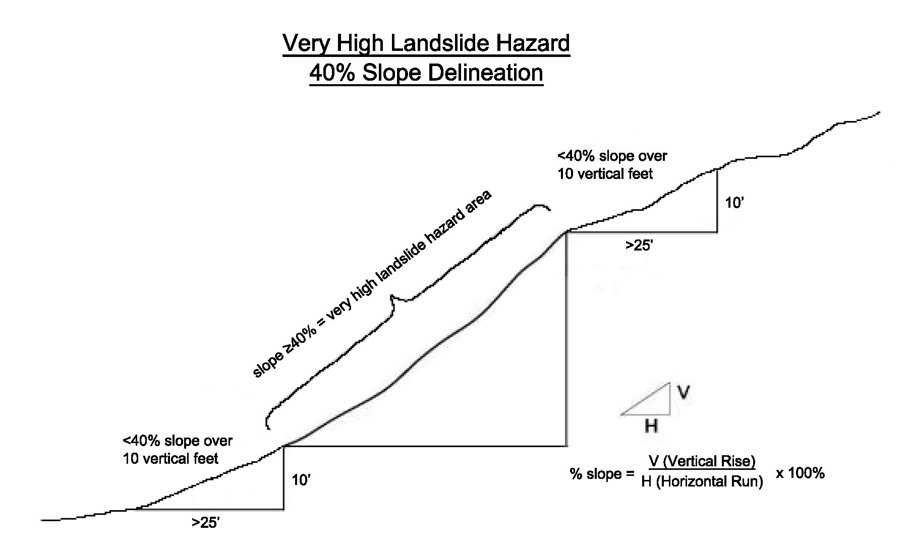
Figure 20.80.215(B): Illustration of Very High Risk Landslide Hazard Area Delineation (No Midslope Bench).
C. Seismic Hazard Areas. Seismic hazard areas are lands that, due to a combination of soil and ground water conditions, are subject to risk of ground shaking, lateral spreading, subsidence or liquefaction of soils during earthquakes. These areas are typically underlain by soft or loose saturated soils (such as alluvium) or peat deposits and have a shallow ground water table. These areas are designated as having “high” and “moderate to high” risk of liquefaction as mapped on the Liquefaction Susceptibility and Site Class Maps of Western Washington State by County by the Washington State Department of Natural Resources.
D. Erosion Hazard Areas. Erosion hazard areas are lands or areas underlain by soils identified by the U.S. Department of Agriculture Natural Resources Conservation Service (formerly the Soil Conservation Service) as having “severe” or “very severe” erosion hazards. This includes, but is not limited to, the following group of soils when they occur on slopes of 15 percent or greater: Alderwood-Kitsap (AkF), Alderwood gravelly sandy loam (AgD), Kitsap silt loam (KpD), Everett (EvD) and Indianola (InD).
E. Slope Modified by Stabilization Measures. Previously permitted slopes modified by stabilization measures, such as rockeries and retaining walls, that have been engineered and approved by the engineer as having been built according to the engineered design shall be exempt from the provisions of this subchapter based on the opinion of a qualified professional. If the rockery or wall(s) are determined to be inadequate by a qualified professional, a permit for new or rebuilt rockery or wall(s) shall be submitted and reviewed by the Department for code compliance. (Ord. 1045 § 1 (Exh. A), 2025; Ord. 907 § 1 (Exh. C), 2020; Ord. 723 § 1 (Exh. A), 2015; Ord. 398 § 1, 2006; Ord. 238 Ch. VIII § 3(B), 2000. Formerly 18.80.220).
20.80.220 Geologic hazards – Buffer areas.
A. Buffers for geologic hazard areas shall be maintained as undisturbed native vegetation consistent with SMC 20.80.040. Building and other improvement setbacks will be required in addition to buffers as recommended by the qualified professional to allow for landscaping, access around structures for maintenance, and location of stormwater facilities at safe distances from geologic hazard areas where native vegetation is not necessary to reduce the risk of the hazard.
B. Required buffer widths for geologic hazard areas shall reflect the sensitivity of the hazard area and the risks associated with development and, in those circumstances permitted by these regulations, the type and intensity of human activity and site design proposed to be conducted on or near the area.
C. In determining the appropriate buffer width, the City shall consider the recommendations contained in a geotechnical critical area report required by these regulations.
D. For moderate to high risk landslide hazard areas, the qualified professional shall recommend whether buffers should be required and the width of those buffers, as well as recommending any additional setbacks for buildings and stormwater facilities adequate to certify no increase in the risk of the hazard.
E. For very high risk landslide hazard areas, the standard buffer shall be 50 feet from all edges of the landslide hazard area. Larger buffers may be required as needed to eliminate or minimize the risk to people and property based on a geotechnical critical area report. The standard buffer may be reduced when geotechnical studies demonstrate, and the qualified professional certifies, that the reduction will not increase the risk of hazard to people or property, on or off site; however, the minimum buffer shall be 15 feet. (Ord. 1045 § 1 (Exh. A), 2025; Ord. 723 § 1 (Exh. A), 2015; Ord. 398 § 1, 2006; Ord. 238 Ch. VIII § 3(C), 2000. Formerly 20.80.230).
20.80.225 Geologic hazards – Critical area report requirements.
A. Report Required. If the Director determines that the site of a proposed development includes, is likely to include, or is adjacent to a geologic hazard area, a critical area report shall be required, at the applicant’s expense. Critical area report requirements for geologic hazard areas are met through submission to the Director of one or more geologic hazard critical area reports. In addition to the general critical areas report requirements of SMC 20.80.065, critical areas reports for geologic hazard areas must meet the requirements of this section. Critical areas reports for two or more types of critical areas must meet the report requirements for each relevant type of critical area.
B. Minimum Report Contents for Geologic Hazard Areas. A critical area report for geologic hazard areas shall contain the following information at a minimum:
1. The minimum report contents required per SMC 20.80.065(D);
2. An assessment of whether or not each type of geologic hazard identified in SMC 20.80.210 is present or not;
3. A determination if the proposed development of the site will increase the risk of the hazard on or off site;
4. Assessment of Geological Characteristics. The report shall include an assessment of the geologic characteristics of the soils, sediments, and/or rock of the project area and potentially affected adjacent properties, and a review of the site history regarding landslides, erosion, and prior grading. Soils analysis shall be accomplished in accordance with accepted classification systems in use in the region. The assessment shall include, but not be limited to:
a. A detailed overview of the field investigations, published data, and references; data and conclusions from past assessments of the site; and site-specific measurements, tests, investigations, or studies that support the identification of geologically hazardous areas; and
b. A summary of the existing site conditions, including:
i. Surface topography, existing features, and vegetation found in the project area and in all hazard areas addressed in the report;
ii. Surface and subsurface geology and soils to sufficient depth based on data from site-specific explorations;
iii. Geologic cross-section(s) displaying the critical design conditions;
iv. Surface and ground water conditions; and
c. A description of the vulnerability of the site to seismic and other geologic events.
5. Analysis of Proposal. The report shall contain a hazards analysis including a detailed description of the project, its relationship to the geologic hazard(s), and its potential impact upon the identified hazard area(s), the subject property, and affected adjacent properties. The hazards analysis component of the critical areas report shall include the following based on the type(s) of geologic hazard areas identified:
a. Recommendations for the minimum buffer consistent with SMC 20.80.220 and recommended minimum drainage and building setbacks from any geologic hazard based upon the geotechnical analysis. Buffers must be maintained consistent with SMC 20.80.040; however, the qualified professional may recommend additional setbacks for drainage facilities or structures which do not have to be maintained as undisturbed native vegetation; and
b. An analysis of proposed surface and subsurface drainage, and the vulnerability of the site to erosion.
C. Additional Technical Information Requirements for Landslide Hazard Areas. The technical information required in a critical area report for a project within a landslide hazard area shall also include the following:
1. An estimate of the present stability of the subject property, the stability of the subject property during construction, the stability of the subject property after all development activities are completed, and a discussion of the relative risks and slide potential relating to adjacent properties during each stage of development, including the effect construction and placement of structures, clearing, grading, and removal of vegetation will have on the slope over the estimated life of the structure;
2. An estimate of the bluff retreat rate that recognizes and reflects potential catastrophic events such as seismic activity or a 100-year storm event;
3. Consideration of the run-out hazard of landslide debris and/or the impacts of landslide run-out on downslope properties;
4. A study of slope stability including an analysis of proposed cuts, fills, and other site grading;
5. Critical area reports for development activities and uses that alter moderate to high risk landslide hazard areas or buffers shall certify:
a. The risk of damage from the proposal, both on site and off site, are minimal subject to the conditions set forth in the report;
b. The proposal will not increase the risk of occurrence of the potential landslide hazard; and
c. Measures to eliminate or reduce risks have been incorporated into the report’s recommendations and project development plans.
6. Critical area reports for development activities and uses that alter very high risk landslide hazard areas or buffers shall include a hazards analysis certifying that:
a. The development will not increase surface water discharge or sedimentation on site or to adjacent properties beyond pre-development conditions;
b. The development will not decrease slope stability on the site or on adjacent properties;
c. Such alterations will meet other critical areas regulations; and
d. The design criteria in SMC 20.80.230(E) are met.
7. Compliance with the requirements of SMC 20.80.230(F) for alterations proposed in very high risk landslide hazard areas;
8 Parameters for design of site improvements including appropriate foundations and retaining structures. These should include allowable load and resistance capacities for bearing and lateral loads, installation considerations, and estimates of settlement performance;
9. Recommendations for drainage and subdrainage improvements;
10. Earthwork recommendations including clearing and site preparation criteria, fill placement and compaction criteria, temporary and permanent slope inclinations and protection, and temporary excavation support, if necessary; and
11. Mitigation of adverse site conditions including slope stabilization measures and seismically unstable soils, if appropriate.
D. Additional Technical Information Requirements for Seismic Hazard Areas. The technical information required in a critical area report for a project within a seismic hazard area shall also include the following:
1. A complete discussion of the potential impacts of seismic activity on the site (for example, forces generated and fault displacement);
2. Additionally, a geotechnical engineering report for a seismic hazard area shall evaluate the physical properties of the subsurface soils, especially the thickness of unconsolidated deposits and their liquefaction potential. If it is determined that the site is subject to liquefaction, mitigation measures appropriate to the scale of the development shall be recommended and implemented; and
3. Any additional information or analysis necessary to demonstrate compliance with the standards for alteration in seismic hazard areas in SMC 20.80.230(G).
E. Limited Report Requirements for Stable Erosion Hazard Areas. When recommended by the qualified professional for sites only overlain by erosion hazard areas with suitable slope stability, and no other type of critical area or buffer, detailed critical areas report requirements may be waived. Report requirements for stable erosion hazard areas may be met through construction documents that shall include at a minimum a stormwater pollution plan prepared in compliance with requirements set forth in Chapter 13.10 SMC. (Ord. 1045 § 1 (Exh. A), 2025; Ord. 723 § 1 (Exh. A), 2015. Formerly 20.80.240).
20.80.230 Geologic hazards – Alterations.
A. Activities and uses shall be allowed in geologic hazard areas and their required buffers only as provided for in this chapter. The City may approve, condition, or deny proposals in a geologic hazard area based upon the effective mitigation of risks posed to property, health and safety. Where potential impacts cannot be effectively mitigated to eliminate a significant risk to public health and safety and property or other critical area, the proposal shall be denied, except as granted by a critical area special use or critical area reasonable use permit per SMC 20.30.333 and 20.30.336, or subject to the provisions of the Shoreline Master Program, SMC Title 20, Division II, where the proposed development activity is located within the shoreline jurisdiction.
B. Activities Allowed in All Geologic Hazards and Buffers. The activities listed below are allowed in the identified geologic hazard areas types. Additional allowed activities are listed in SMC 20.80.080, Allowed activities. Exemptions are listed in SMC 20.80.075, but do not apply within the shoreline jurisdiction. These activities do not require submission of a critical area report.
1. Installation of fences as allowed without a building permit in Chapter 20.50 SMC, General Development Standards. Excluding significant trees, the minimum removal of vegetation from a geologic hazard area necessary to enable fence installation is allowed;
2. If the project is located in an erosion hazard area and is not located in another type of critical area or critical area buffer and does not exceed any other threshold contained in SMC 20.50.320, then up to 1,500 square feet may be cleared on any lot in an erosion hazard area without a permit.
C. Alteration of Moderate to High Risk Landslide Hazards. Development activities and uses that result in unavoidable alterations may be permitted in moderate to high risk landslide hazard areas or their buffers in accordance with an approved geologic hazard critical area report. The recommendations contained within the critical area report shall be incorporated into the proposed alteration of the landslide hazard area or its buffers.
D. Alteration of Very High Risk Landslide Hazard Areas. Development activities and uses that result in unavoidable alterations may be permitted in very high risk landslide hazard areas or their buffers in accordance with an approved geologic hazard critical area report. The recommendations contained within the critical area report shall be incorporated into the proposed alteration of the landslide hazard area or its buffers.
E. Design Criteria for Alteration of Very High Risk Landslide Hazard Areas. Development within a very high risk landslide hazard area and/or buffer shall be designed to meet the following basic requirements unless it can be demonstrated that an alternative project design provides greater short- and long-term slope stability while meeting all other provisions of this chapter. The requirement for long-term slope stability shall exclude designs that require regular and periodic maintenance to maintain their level of function. The basic development design criteria are:
1. The proposed development shall not decrease the factor of safety for landslide occurrences below the limits of 1.5 for static conditions and 1.2 for dynamic conditions. Proposed alteration of natural slopes, that does not include structures, shall not decrease the factor of safety for landslide occurrences below the limits of 1.3 for static conditions and 1.0 for seismic. Where the existing conditions are below these limits, the proposed development shall increase the factor of safety to these limits or will not be permitted. Analysis of dynamic conditions shall be based on the seismic event as established by the current version of the International Building Code;
2. New structures and improvements shall be clustered to avoid geologic hazard areas and other critical areas;
3. New structures and improvements shall minimize alterations to the natural contour of the slope, and foundations shall be tiered where possible to conform to existing topography;
4. New structures and improvements shall be located to preserve the most critical portion of the site and its natural landforms and vegetation;
5. The proposed development shall not result in greater risk of the hazard or a need for increased buffers on neighboring properties;
6. Where the existing natural slope area cannot be retained undisturbed with native vegetation, the use of retaining walls that allow the maintenance of existing natural slope area is preferred over graded artificial slopes; and
7. Development shall be designed to minimize impervious lot coverage and preserve native vegetation and trees to the maximum extent practicable.
F. Additional Requirements for Alteration of Very High Risk Hazard Landslide Areas.
1. Prior to application, the applicant shall meet the requirements of and conduct a neighborhood meeting consistent with SMC 20.30.090. The notification area shall be limited to:
a. All property owners whose properties adjoin the subject property; and
b. Properties that include part of the subject property’s very high risk landslide hazard area and the standard 50-foot buffer, but not to exceed a maximum of 200 feet from the project clearing limits.
2. Prior to permit issuance, the property owner shall sign and record on title, at the owner’s sole expense, a covenant in a form acceptable to the City, which:
a. Acknowledges and accepts the risks of development in the landslide hazard area;
b. Waives any rights to claims against the City;
c. Indemnifies and holds harmless the City against claims, losses, and damages;
d. Informs subsequent owners of the property of the risks and the covenant; and
e. Advisability of obtaining added insurance.
3. Prior to permit issuance, the piling and excavation contractors shall submit insurance bonding documentation that includes coverage for subsidence and underground property damage, listing the City as an additional insured. The Director may require adequate bonds and/or insurance to cover potential claims for property damage that may arise from or be related to the following:
a. Excavation or fill within a landslide-prone area when the depth of the proposed excavation exceeds four feet and the bottom of the proposed excavation is below the 100 percent slope line (45 degrees from a horizontal line) from the property line; or
b. In other circumstances where the Director determines that there is a potential for significant harm to any type of critical area or a critical area buffer during the construction process.
4. If the Building Official has reasonable grounds to believe that an emergency exists because significant changes in geologic conditions at a project site or in the surrounding area may have occurred since a permit was issued, increasing the risk of damage to the proposed development, to neighboring properties, or to nearby surface waters, the building official may, by letter or other reasonable means of notification, suspend the permit until the applicant has submitted a letter of certification. The letter of certification shall be based on such factors as the presence of known slides, indications of changed conditions at the site or the surrounding area, or other indications of unstable soils and meet the following requirements:
a. The letter of certification shall be from the current project qualified professional geotechnical engineer of record stating that a qualified professional geotechnical engineer has inspected the site and area surrounding the proposed development within the 60 days preceding submittal of the letter; and that:
i. In the project geotechnical engineer’s professional opinion no significant changes in conditions at the site or surrounding area have occurred that render invalid or out-of-date the analysis and recommendations contained in the technical reports and other application materials previously submitted to the City as part of the application for the permit; or that
ii. In the project geotechnical engineer’s professional opinion, changes in conditions at the site or surrounding area have occurred that require revision to project criteria and that all technical reports and any necessary revised drawings that account for the changed conditions have been prepared and submitted.
5. The letter of certification and any required revisions shall be reviewed and approved by the City’s third party qualified professional, at the applicant’s expense, before the Building Official may allow work to continue under the permit.
G. Alteration of Seismic Hazard Areas. Development activities and uses in seismic hazard areas may be permitted, not subject to SMC 20.80.095(A)(1), based on review of a critical area report demonstrating that the project is consistent with SMC 20.80.095(A)(2) through (A)(6). The report must certify that the risks of damage from the proposal, both on site and off site, are minimal subject to the conditions set forth in the report, that the proposal will not increase the risk of occurrence of the potential hazard, and that measures to eliminate or reduce risks have been incorporated into the report’s recommendations. The report must include the following:
1. For one-story and two-story detached residential structures, a qualified professional shall conduct an evaluation of site response and liquefaction potential based on current mapping, site reconnaissance, research of nearby studies.
2. For all other proposals, the qualified professional shall conduct an evaluation of site response and liquefaction potential including sufficient subsurface exploration to determine the site coefficient for use in the static lateral force procedure described in the International Building Code.
H. Alteration of Erosion Hazard Areas. Development activities and uses in erosion hazard areas may be permitted, not subject to SMC 20.80.095(A)(1), based on review of a critical area report demonstrating that the project is consistent with SMC 20.50.095(A)(2) through (A)(6) and the following provisions:
1. All development proposals on sites containing erosion hazard areas shall include a mitigation plan to ensure revegetation and permanent stabilization of the site. Specific requirements for revegetation in mitigation plans shall be consistent with the mitigation plan requirements in SMC 20.80.100 and the mitigation performance standards for geologic hazard areas in SMC 20.80.235. Revegetation for site stabilization may be combined with required landscape, tree retention, and/or other critical area mitigation plans as appropriate.
2. All subdivisions, short subdivisions or binding site plans on sites with erosion hazard areas shall comply with the following additional requirements:
a. Except as provided in this section, existing vegetation shall be retained on all lots until building permits are approved for development on individual lots;
b. If any vegetation on the lots is damaged or removed during construction of the subdivision infrastructure, the applicant shall be required to implement the revegetation plan in those areas that have been impacted prior to final inspection of the site development permit or the issuance of any building permit for the subject property;
c. Clearing of vegetation on individual lots may be allowed prior to building permit approval if the City determines that:
i. Such clearing is a necessary part of a large-scale grading plan;
ii. It is not feasible to perform such grading on an individual lot basis; and
iii. Drainage from the graded area will meet established water quality standards.
3. Where the City determines that erosion from a development site poses a significant risk of damage to downstream receiving water, the applicant shall be required to provide regular monitoring of surface water discharge from the site during the project construction or installation. If the project does not meet water quality standards, the City may suspend further development work on the site until such standards are met.
4. The City may require additional mitigation measures in erosion hazard areas, including, but not limited to, the restriction of major soil-disturbing activities associated with site development between October 1st and April 30th to meet the stated purpose contained in SMC 20.80.010 and 20.80.210.
5. The use of hazardous substances, pesticides and fertilizers in erosion hazard areas may be prohibited by the City. (Ord. 1045 § 1 (Exh. A), 2025; Ord. 723 § 1 (Exh. A), 2015. Formerly 20.80.224).
20.80.235 Geologic hazards – Mitigation.
A. Requirements for Mitigation. Mitigation is required for proposed adverse impacts and increased risks of alteration of geologic hazard areas. The objective of mitigation measures shall be to render a site containing geologic hazards as safe as one not containing such a hazard. Mitigation plans shall be submitted as part of the required critical area report, consistent with the requirements of SMC 20.80.100, and this section.
B. Preference of Mitigation Actions. Methods to achieve mitigation for alterations of geologic hazard areas shall be approached in the following order of preference:
1. Protection. Mitigation measures that increase the protection of the identified geologic hazard areas include, but are not limited to:
a. Increased or enhanced buffers;
b. Setbacks for permanent and temporary structures;
c. Reduced project scope; and
d. Retention of existing vegetation.
2. Restoration. Restoration of native vegetation.
3. Engineered Stabilization. Engineered design of geologic hazard stabilization to ensure no increased risk of the hazard due to the proposal with preference for bioengineering over structural engineered solutions.
C. Performance Standards. The following performance standards shall apply to any mitigation for development proposed within geologic hazard areas:
1. Geotechnical studies shall be prepared by a qualified professional to identify and evaluate potential hazards and to formulate mitigation measures;
2. Construction methods will reduce or not adversely affect geologic hazards;
3. Site planning to minimize disruption of existing topography and natural vegetation;
4. Significant trees shall be preserved, unless removal is unavoidable or otherwise allowed under the provisions of this chapter;
5. Minimize impervious surface coverage;
6. Replant disturbed areas as soon as feasible pursuant to an approved landscape plan. When planting is required, the following standards shall apply:
a. Native species, indigenous to the region, shall be used;
b. Plant selection shall be consistent with the existing or projected site conditions, including slope aspect, moisture, and shading;
c. Plants should be commercially available or available from local sources;
d. Plant species high in food and cover value for fish and wildlife shall be used;
e. A minimum of 75 percent of the planted species shall be perennial, unless a lower percentage is recommended by a qualified professional;
f. Committing significant areas of the site to species that have questionable potential for successful establishment shall be avoided;
g. Plant selection, densities, and placement of plants must be determined by a qualified professional and shown on the design plans;
h. Stockpiling soil and construction materials should be confined to upland areas and contract specifications should limit stockpiling of earthen materials to durations in accordance with City clearing and grading standards, unless otherwise approved by the City;
i. Planting instructions shall be submitted which describe placement, diversity, and spacing of seeds, tubers, bulbs, rhizomes, sprigs, plugs, and transplanted stock;
j. Controlled release fertilizer shall be applied (if required) at the time of planting and afterward only as plant conditions warrant as determined during the monitoring process;
k. An irrigation system shall be installed, if necessary, for the initial establishment period; and
l. The heterogeneity and structural diversity of vegetation shall be emphasized in landscaping;
7. The use of retaining walls that allow maintenance of existing natural slope areas are preferred over graded slopes;
8. Undevelopable geologic hazard areas larger than one-half acre shall be placed in a separate tract, provided this requirement does not make the lot nonconforming;
D. Mitigation of Long Term Impacts. When hazard mitigation is required, the mitigation plan shall specifically address how the activity maintains or reduces the preexisting level of risk to the site and adjacent properties on a long-term basis (equal to or exceeding the projected lifespan of the activity or occupation). Proposed mitigation techniques shall be considered to provide long-term hazard reduction only if they do not require regular maintenance or other actions to maintain their function. Mitigation may also be required to avoid any increase in risk above the preexisting conditions following abandonment of the activity. (Ord. 1045 § 1 (Exh. A), 2025; Ord. 723 § 1 (Exh. A), 2015; Ord. 398 § 1, 2006; Ord. 238 Ch. VIII § 3(E), 2000. Formerly 20.80.250).
Subchapter 3.
Fish and Wildlife Habitat Conservation Areas
20.80.310 Fish and wildlife habitat – Designation and purpose.
A. Fish and wildlife habitat conservation areas are lands managed for maintaining populations of species in suitable habitats within their natural geographic distribution so that the habitat available is sufficient to support viable populations over the long term and isolated subpopulations are not created.
Fish and wildlife habitat conservation areas include:
1. Areas with which State and Federal designated threatened, endangered, and sensitive species have a primary association; and
2. Priority species and habitats listed by the Washington State Department of Fish and Wildlife, including corridors which connect priority habitat features; and
3. Areas which provide habitat for species of local significance, which have been or may be identified in the City of Shoreline Comprehensive Plan; and
4. Streams and riparian management zones which provide important habitat corridors; help maintain water quality; store and convey stormwater and floodwater; recharge ground water; and serve as areas for recreation, education, scientific study, and aesthetic appreciation; and
5. Wetlands and their associated buffers; and
6. The waters, bed and shoreline of Puget Sound up to the ordinary high water mark.
B. The purpose of fish and wildlife habitat conservation areas is to:
1. Protect Federal and State listed habitats and species and give special attention to protection and enhancement of anadromous fish populations; and
2. Maintain a diversity of species and habitat within the City; and
3. Coordinate habitat protection to maintain and provide habitat connections; and
4. Help maintain air and water quality and control erosion. (Ord. 1045 § 1 (Exh. A), 2025; Ord. 723 § 1 (Exh. A), 2015; Ord. 398 § 1, 2006; Ord. 238 Ch. VIII § 4(A), 2000. Formerly 20.80.260).
20.80.315 Fish and wildlife habitat – Classification.
Fish and wildlife habitat conservation areas are those areas designated by the City based on review of the best available science; input from Washington Department of Fish and Wildlife, Washington Department of Ecology, U.S. Army Corps of Engineers, Tribes, and other agencies; and any of the following criteria:
A. Areas Where State or Federally Designated Endangered, Threatened, and Sensitive Species Have a Primary Association.
1. Federally designated endangered and threatened species are those fish and wildlife species identified by the U.S. Fish and Wildlife Service and the National Marine Fisheries Service that are in danger of extinction or threatened to become endangered. The U.S. Fish and Wildlife Service and the National Marine Fisheries Service should be consulted for current listing status. Federally designated endangered and threatened species known to be identified and mapped by the Washington State Department of Wildlife in Shoreline include, but may not be limited to, the following:
a. Chinook (Oncorhynchus tshawytscha);
b. Southern resident orca or killer whales (Orcinus orca).
c. Puget Sound steelhead (Oncorhynchus mykiss).
2. State designated endangered, threatened, and sensitive species are those fish and wildlife species native to the State of Washington that are in danger of extinction, threatened to become endangered, vulnerable, or declining and are likely to become endangered or threatened in a significant portion of their range within the State without cooperative management or removal of threats as identified by the Washington State Department of Fish and Wildlife. State designated endangered, threatened, and sensitive species are periodically recorded in WAC 232-12-014 (State endangered species) and WAC 232-12-011 (State threatened and sensitive species). The State Department of Fish and Wildlife maintains the most current listing and should be consulted for current listing status. State designated endangered, threatened, and sensitive species known to be identified and mapped by the Department of Fish and Wildlife in Shoreline include, but may not be limited to, the following:
a. Northern goshawk (Accipiter gentilis);
b. Purple martin (Progne subis).
B. State Priority Habitats and Species. Priority habitats and species are considered to be priorities for conservation and management. Priority habitats are those habitat types or elements with unique or significant value to a diverse assemblage of species. Priority habitats and species are identified by the State Department of Fish and Wildlife (DFW) in the Priority Habitats and Species List. Priority habitats and species known to be identified and mapped by the Department of Fish and Wildlife in Shoreline include, but may not be limited to, the following:
1. Biodiversity areas and corridors identified and mapped along Boeing Creek and in and around Innis Arden Reserve Park;
2. Chinook/fall chinook (Oncorhynchus tshawytscha);
3. Coho (Oncorhynchus kisutch);
4. Dungeness crab (Cancer magister);
5. Estuarine intertidal aquatic habitat;
6. Geoduck (Panopea abrupta);
7. Northern goshawk (Accipiter gentilis);
8. Pacific sand lance (Ammodytes hexapterus);
9. Purple martin (Progne subis);
10. Resident coastal cutthroat (Oncorhynchus clarki);
11. Surf smelt (Hypomesus pretiosus);
12. Waterfowl concentrations at Ronald Bog (Ronald Bog is not a shoreline of the State subject to the SMP); and
13. Winter steelhead (Oncorhynchus mykiss).
C. Commercial and Recreational Shellfish Areas. These areas include all public and private tidelands or bedlands suitable for shellfish harvest, including shellfish protection districts established pursuant to Chapter 90.72 RCW.
D. Kelp and eelgrass beds and herring and smelt spawning areas.
E. Waters of the State. Waters of the State include lakes, rivers, ponds, streams, inland waters, underground waters, salt waters, and all other surface waters and watercourses within the jurisdiction of the State of Washington, as classified in WAC 222-16-030. Streams are those areas where surface waters produce a defined channel or bed, not including irrigation ditches, canals, storm or surface water runoff devices or other entirely artificial watercourses, unless they are used by fish or are used to convey streams naturally occurring prior to construction. A channel or bed need not contain water year-round; provided, that there is evidence of at least intermittent flow during years of normal rainfall. Streams shall be classified in accordance with the Washington Department of Natural Resources water typing system (WAC 222-16-030) hereby adopted in its entirety by reference. (Ord. 1045 § 1 (Exh. A), 2025; Ord. 723 § 1 (Exh. A), 2015; Ord. 398 § 1, 2006; Ord. 238 Ch. VIII § 4(B), 2000. Formerly 20.80.270).
20.80.320 Fish and wildlife habitat – Buffer areas and riparian management zone.
A. Buffer widths for fish and wildlife habitat areas shall be based on consideration of the following factors: species-specific recommendations of the Washington State Department of Fish and Wildlife; recommendations contained in a habitat management plan submitted by a qualified professional; and the nature and intensity of land uses and activities occurring on the land adjacent to the site.
B. Riparian management zones are the area adjacent to a stream that has the potential to provide full riparian ecosystem functions for a stream including but not limited to bank stability, shade, pollution removal, contributions of detrital nutrients, recruitment of large woody debris, and wildlife habitat.
C. Standard Required Riparian Management Zone Widths. Riparian management zones shall be located on both sides of the stream and measured from the ordinary high water mark (OHWM) or the top of the bank, or the outer edge of the channel migration zone (if one exists), whichever is greater. Based on the site potential tree height (SPTH200) in the Washington State Department of Fish and Wildlife’s 2020 Riparian Ecosystems, Volume 2: Science Synthesis and Management Implications, all streams in Shoreline, except piped streams, have a standard riparian management zone width of 200 feet. Piped streams do not have a riparian management zone, but rather a buffer of 10 feet on each side of the piped stream. Buffers of piped streams shall be measured with rounded ends where streams enter or exit piped segments.
D. Increased Riparian Management Zone Widths. The standard riparian management zone widths shall be increased, as follows:
1. When the qualified professional determines that the standard width is insufficient to protect the functions and values of the stream;
2. When the flood hazard area exceeds the standard width, the riparian management zone shall extend to the outer edge of the flood hazard area; or
3. When the habitat area is within an erosion or landslide hazard area, or buffer, the riparian management zone width shall be the recommended distance, or the erosion or landslide hazard area or buffer, whichever is greater.
E. Reduced Riparian Management Zone Width. A reduced standard riparian management zone width may be allowed under the following circumstances:
1. A report prepared by a qualified professional is submitted that demonstrates that the site potential tree height (SPTH200) of the predominant tree species is less than the standard width; however, the minimum riparian management zone width shall not be less than 100 feet. The report shall include a site-specific soil analysis completed by a licensed geologist or related licensed professional using Washington Department of Fish and Wildlife’s most recent version of Guidelines for Determining Site Potential Tree Height from Field Measurements;
2. When the voluntary daylighting of a stream that is not required as mitigation for a development proposal a 25 percent reduction to the standard riparian management zone width is allowed. Further reductions in the standard riparian management zone width may be granted for daylighting if all of the following are demonstrated:
a. A riparian management zone 75 percent of standard width would significantly limit the use of the property for existing or permitted uses, thus making the restoration project infeasible;
b. The proposed width reduction is the minimum necessary to achieve the restoration project;
c. There will be a net environmental benefit from the restoration project with the reduced riparian management zone width; and
d. Granting the proposed relief is consistent with the objectives of the stream daylighting project and consistent with purposes of the City’s critical area regulations.
3. A maximum of 25 percent reduction to the standard riparian management zone width may be allowed, provided the following criteria are met:
a. The riparian management zone area being reduced is already impacted by legally constructed nonconforming improvements or sparsely vegetated or vegetated with invasive species; and
b. A qualified professional provides an assessment of existing functions of the riparian management zone consistent with SMC 20.80.325(B)(4); and
c. A qualified professional provides an on-site riparian management zone enhancement plan. On-site enhancement measures may include enhancement to the riparian management zone or the stream. The enhancement measures determined most applicable and/or appropriate will be considered. The enhancement plans shall include a written assessment and accompanying maps and a planting plan of site-appropriate native species at natural densities including the following information at a minimum:
i. A description of existing riparian management zone conditions and existing ecological functions;
ii. A description of proposed riparian management zone enhancement measures and how proposed enhancement measures will increase riparian management zone functions in terms of stream and fish habitat protection;
iii. A finding that the riparian management zone width reduction and associated enhancement result in no net loss of ecological function and that enhancement will improve upon existing functions; and
iv. A monitoring program and contingency plan consistent with SMC 20.80.100(D).
F. Physically Separated and Functionally Isolated Riparian Management Zones. Consistent with the definition of Riparian Management Zones (SMC 20.20.044), areas that are functionally isolated and physically separated from stream due to existing, legally established roadways, railroads or other legally established structures or paved areas eight feet or more in width that occur between the area in question and the stream shall be considered physically isolated and functionally separated from the stream and shall not be subject to the standards of this chapter. The obstruction causing the physical isolation or functional separation shall be significant enough in size that the riparian management zone cannot reasonably perform any of the ecological functions of a riparian management zone including bank stability, shade, pollution removal, contributions of detrital nutrients, recruitment of large woody debris, and wildlife habitat. A critical areas assessment prepared by a qualified professional determining whether the area is functionally isolated is required unless deemed unnecessary by the Director. (Ord. 1045 § 1 (Exh. A), 2025; Ord. 907 § 1 (Exh. B), 2020; Ord. 723 § 1 (Exh. A), 2015; Ord. 398 § 1, 2006; Ord. 238 Ch. VIII § 4(C), 2000. Formerly 20.80.280).
20.80.325 Fish and wildlife habitat – Critical area report requirements.
A. Report Required. If the Director determines that the site of a proposed development includes, is likely to include, or is adjacent to a fish and wildlife habitat conservation area, a critical area report shall be required. Critical area report requirements for fish and wildlife habitat conservation areas are generally met through submission to the Director of one or more fish and wildlife habitat critical area reports. In addition to the general critical area report requirements of SMC 20.80.065, critical area reports for fish and wildlife habitat conservation areas must meet the requirements of this section. Critical area reports for two or more types of critical areas must meet the report requirements for each relevant type of critical area.
B. Minimum Report Contents for Fish and Wildlife Habitat Conservation Areas. The critical area written report(s) and accompanying plan sheet(s) shall contain the following information at a minimum:
1. The minimum report contents required per SMC 20.80.065(D);
2. A discussion of the potential impacts to the fish and wildlife habitat conservation areas associated with anticipated hydroperiod alterations from the project;
3. Habitat Assessment. A critical area report for a fish and wildlife habitat conservation area shall contain an assessment of habitats including the following site- and proposal-related information at a minimum:
a. Detailed description of vegetation on and adjacent to the project area and its associated buffer;
b. Identification of any species of local importance, priority habitat or species, or endangered, threatened, sensitive, or candidate species that have a primary association with habitat on or adjacent to the project area, and assessment of potential project impacts to the use of the site by the species;
c. A discussion of any Federal, State, or local special management recommendations, including Washington Department of Fish and Wildlife habitat management recommendations, that have been developed for species or habitats located on or adjacent to the project area;
d. A detailed discussion of the direct and indirect potential impacts on habitat by the project, including potential impacts to water quality;
e. A discussion of ongoing management practices that will protect habitat after the project site has been developed, including proposed monitoring and maintenance programs.
4. Additional Technical Information Requirements for Streams. Critical area reports for streams must be consistent with the specific development standards for streams in SMC 20.80.330 and may be met through submission of one or more specific report types. In addition to the basic critical area report requirements for fish and wildlife habitat conservation areas, technical information on streams shall include the following information at a minimum:
a. A written assessment and accompanying maps of the stream and associated hydrologic features on and off site within 300 feet of the project area meeting the standards set by the Director.
b. A detailed description and functional assessment of the riparian management zone under existing conditions pertaining to the protection of stream functions, fish habitat and, in particular, potential anadromous fisheries;
c. A habitat and native vegetation conservation strategy that addresses methods to protect and enhance on-site habitat and stream functions;
d. A discussion of ongoing management practices that will protect stream functions and habitat value through maintenance of vegetation density within the riparian management zone. (Ord. 1045 § 1 (Exh. A), 2025; Ord. 723 § 1 (Exh. A), 2015. Formerly 20.80.290).
20.80.330 Fish and wildlife habitat – Alterations.
A. Activities and uses shall be prohibited in fish and wildlife habitat conservation areas and associated buffers, except as provided for in this subchapter. Unless specifically exempted under SMC 20.80.075 and/or allowed under SMC 20.80.080, or this section, development activities and uses that result in alteration of fish and wildlife habitat conservation areas shall be subject to the critical area reasonable use and special use provisions of SMC 20.30.333 and 20.30.336, or subject to the provisions of the Shoreline Master Program where located within the shoreline jurisdiction.
B. Activities Allowed in Fish and Wildlife Habitat Conservation Areas. The activities listed below are allowed in fish and wildlife habitat conservation areas. Additional allowed activities are listed in SMC 20.80.080, Allowed activities. Exemptions are listed in SMC 20.80.075, but do not apply within the shoreline jurisdiction. These activities do not require the submission of a critical area report.
1. Conservation or preservation of soil, water, vegetation, fish, shellfish, and/or other wildlife that does not entail changing the structure or functions of the existing habitat conservation area.
2. Clearing, grading, and the construction of fences and arbors are allowed within the required 10-foot stream buffers for a piped stream segment, if no other critical area or buffer is present.
C. Activities Allowed in Riparian Management Zones. The activities listed below are allowed in riparian management zones with the approval of a critical area report consistent with SMC 20.80.065 and 20.80.325. Additional allowed activities are listed in SMC 20.80.080, Allowed activities. Exemptions are listed in SMC 20.80.075, but do not apply within the shoreline jurisdiction.
1. New Road and Utilities. Construction of new roads, utilities, and associated accessory structures, when no feasible alternative location exists; or
2. Low Impact Stormwater Management Facilities. Establishment of low-impact stormwater management facilities, such as stormwater dispersion outfalls and bioswales, may be allowed consistent with the adopted stormwater manual; provided, that:
a. No other location is feasible;
b. Pipes and conveyance facilities only in the outer 25 percent of the riparian management zone;
c. Low-impact stormwater management facilities consistent with the adopted stormwater manual may be allowed anywhere within riparian management zones when determined by a qualified professional that the location of the facility will enhance the riparian management zone and protect the stream; and
d. Such facilities are designed consistent with the requirements of SMC 20.70.330.
3. One Time Expansion. A one-time expansion of hardscape, up to 500 square feet, on an existing legally developed property lying within the riparian management zone may be permitted when the following conditions are met:
a. The expansion would occur at least 100 feet from the edge of the stream’s ordinary high water mark; and
b. The expansion is no closer to the stream’s ordinary high-water mark than the existing legally established development; and
c. The expansion is consistent with other applicable development regulations; and
d. A mitigation plan consistent with SMC 20.80.100 and 20.80.335 is approved; and
e. Prior to final inspection, the applicant shall record a covenant or other restriction with the subject property’s title indicating that no further expansion of the building footprint or hardscape area is allowed within the riparian management zone on the site.
D. General Standards for Alteration of Fish and Wildlife Habitat Conservation Areas.
1. No plant, wildlife, or fish species not indigenous to the region shall be introduced into a fish and wildlife habitat conservation area unless authorized by a State or Federal permit or approval.
2. When a species is more susceptible to adverse impacts during specific periods of the year, seasonal restrictions may apply. Larger buffers may be required and activities may be further restricted during the specified season.
3. The subdivision and short subdivision of land in fish and wildlife habitat conservation areas and associated buffers or riparian management zones is subject to the following:
a. Land that is located wholly within a fish and wildlife habitat conservation area or its buffer may not be subdivided;
b. Land that is located partially within a fish and wildlife habitat conservation area or its buffer may be divided; provided, that the developable portion of each new lot and its access is located outside of the fish and wildlife habitat conservation area or its buffer. The final lots must each meet the minimum lot size requirements of SMC 20.50.020.
c. Access roads and utilities serving the proposed subdivision may be permitted within the fish and wildlife habitat conservation area and associated buffers only if the applicant’s qualified professional(s) demonstrate, and the City determines, that no other feasible alternative exists, all unavoidable impacts are fully mitigated, and the use is consistent with this chapter.
E. Alteration of Endangered, Threatened, and Sensitive Species Habitat. No development shall be allowed within a fish and wildlife habitat conservation area or buffer with which State or Federally endangered, threatened, or sensitive species have a primary association, except that which is provided for by a management plan established by the Washington Department of Fish and Wildlife or applicable State or Federal agency.
1. Whenever activities are proposed adjacent to a fish and wildlife habitat conservation area with which State or Federally endangered, threatened, or sensitive species have a primary association, such area shall be protected through the application of protection measures in accordance with a critical area report prepared by a qualified professional and approved by the City. Approval for alteration of the fish and wildlife habitat conservation area or its buffer shall not occur prior to consultation with the Washington Department of Fish and Wildlife for animal species, the Washington State Department of Natural Resources for plant species, and other appropriate Federal or State agencies.
F. Alteration of Priority Habitats. Fish and wildlife habitat conservation areas or buffers with which species that are not State or Federally listed as endangered, threatened, or sensitive species and are not anadromous fish species shall be subject to the following:
1. Development activities and uses that result in unavoidable impacts may be permitted in priority species habitat areas and associated buffers in accordance with an approved critical area(s) report and habitat management plan, and only if the proposed activity is the only reasonable alternative that will accomplish the applicant’s objectives. Full compensation for the loss of acreage and functions of habitat and buffer areas shall be provided in compliance with the mitigation performance standards and requirements of these regulations.
G. Additional Requirements for Alteration of Waters Containing Anadromous Fish. All activities, uses, and alterations proposed to be located in water bodies used by anadromous fish or in areas that affect such water bodies shall give special consideration to the preservation and enhancement of anadromous fish habitat, including, but not limited to, adhering to the following standards:
1. Subsection E of this section applies to anadromous fish where those populations are identified as endangered, threatened or sensitive species;
2. Activities shall be timed to occur only during the allowable work window as designated by the Washington Department of Fish and Wildlife for the applicable species;
3. An alternative alignment or location for the activity is not feasible;
4. The activity is designed so that it will not degrade the functions or values of the fish habitat or other critical areas and any impacts to the functions or values of the fish and wildlife habitat conservation area are mitigated in accordance with an approved critical area report;
5. Shoreline erosion control measures shall be designed to use bioengineering methods or soft armoring techniques, according to an approved critical area report; and
6. Structures that prevent migration shall not be allowed in the portion of water bodies currently or historically used by anadromous fish. Fish bypass facilities shall be provided, consistent with RCW 77.57.030, that allow the upstream migration of adult fish and prevent fry and juveniles migrating downstream from being trapped or harmed; and
7. Fills, when authorized by the City and all applicable joint aquatic resource permit application approvals, shall not adversely impact anadromous fish or their habitat or shall mitigate any unavoidable impacts and shall only be allowed for a water-dependent use.
H. Additional Requirements for Alteration of Streams. All activities shall be designed and constructed in accordance with applicable state regulations, including provisions governing fish passage and habitat protection.
1. Type S, F and Np Streams. Unless specifically exempted under SMC 20.80.075 and/or allowed under SMC 20.80.080, or this section, development activities and uses that result in alteration of type S, F and Np streams and their riparian management zones shall be prohibited, subject to the critical area reasonable use and special use provisions of SMC 20.30.333 and 20.30.336, or subject to the provisions of the Shoreline Master Program where located within the shoreline jurisdiction.
2. Type Ns Streams. Development activities and uses that result in unavoidable impacts may be permitted in Type Ns streams and associated riparian management zones in accordance with an approved critical area(s) report and compensatory mitigation plan, and only if the proposed activity is the only reasonable alternative that will accomplish the applicant’s objectives. Full compensation for the loss of acreage and functions of streams and riparian management zones shall be provided in compliance with the mitigation performance standards and requirements of these regulations.
3. Stream Crossing. Crossing of streams may be permitted based on the findings in a critical area report, subject to the limitations in subsections (H)(1) and (H)(2) of this section, and consistent with the following:
a. Bridges. Bridges shall be used to cross Type S and Type F-anadromous streams. Culverted crossings and other obstructive means of crossing Type S and Type F-anadromous streams shall be prohibited; and
b. Culverts. Culverts are allowed for crossing of Type F-nonanadromous, Np, and Ns streams when fish passage will not be impaired and when the following design criteria and conditions are met:
i. The City may require that a culvert be removed from a stream as a condition of approval, unless it is demonstrated conclusively that the culvert is not detrimental to fish habitat or water quality, or removal would be detrimental to fish or wildlife habitat or water quality.
4. Relocation. Relocation of a Type S, F, or Np stream may be allowed, subject to the limitations in subsections (H)(1) of this section, and only when the proposed relocation is part of an approved mitigation or rehabilitation plan, will result in equal or better habitat and water quality, and will not diminish the flow capacity of the stream. Relocation of a Type Ns stream may be allowed, subject to the limitation in subsection (H)(2) of this section, and only when the proposed relocation will result in equal or better habitat and water quality and will not diminish the flow capacity of the stream.
5. Restoring Piped Watercourses. The City allows the voluntary opening of previously channelized/culverted streams and the rehabilitation and restoration of streams. Restoring piped watercourses may be approved, consistent with the following:
a. When piped watercourse sections are restored, a riparian management zone shall be required of the stream section. The width shall be consistent with SMC 20.80.320(E)(2). The stream and riparian management zone shall include habitat improvements and measures to prevent erosion, landslide, and water quality impacts. Opened channels shall be designed to support fish and wildlife habitat and uninhibited fish access, unless determined to be unfeasible as demonstrated in a restoration plan reviewed and approved by the City;
b. Removal of pipes conveying streams shall only occur when the City determines that the proposal will result in an improvement of water quality and ecological functions and will not significantly increase the threat of erosion, flooding, slope stability, or other hazards; and
c. Where the riparian management zone of the restored stream would extend onto an adjacent property, the applicant shall obtain a written agreement from the affected neighboring property owner prior to the City approving the restoration of the piped watercourse.
I. Alteration of Wetland Habitats. All proposed activities within or adjacent to fish and wildlife habitat conservation areas containing wetlands shall conform to the wetland development performance standards set forth in Chapter 20.80 SMC, Subchapter 4, Wetlands. If nonwetlands habitat and wetlands are present at the same location, the provisions of this subchapter or the Wetlands subchapter, whichever provides greater protection to the habitat, apply. (Ord. 1045 § 1 (Exh. A), 2025; Ord. 723 § 1 (Exh. A), 2015. Formerly 20.80.274 and 20.80.276).
20.80.335 Fish and wildlife habitat – Mitigation.
A. Requirements for Mitigation. Mitigation is required where impacts cannot be avoided and must be sufficient to achieve no net loss of ecological functions. Mitigation shall be consistent with the recommendations specific to the habitat or species of the Washington State Department of Fish and Wildlife Priority Habitat Program. Mitigation plans shall be prepared by a qualified professional and submitted as part of the required critical area report, consistent with the requirements of SMC 20.80.100, and this section.
1. Additional Requirements for Stream Mitigation. Proposals which include mitigation for impacts to stream area functions and values shall demonstrate that:
a. All feasible and reasonable measures will be taken to reduce impacts and losses to the stream, or to avoid impacts where avoidance is required by these regulations;
b. The mitigated stream area or riparian management zone will be available and persistent as the stream or riparian management zone being compensated for; and
c. No overall net loss will occur in stream functions and values.
B. Preference of Mitigation Actions. Methods to achieve compensation for fish and wildlife habitat functions and values shall be approached in the following order of preference:
1. Protection. Mitigation measures that increase the protection of the identified fish and wildlife habitat conservation areas may include but are not limited to:
a. Increased or enhanced buffers;
b. Setbacks for permanent and temporary structures;
c. Reduced project scope;
d. Limitations on construction hours including seasonal restrictions of construction activities;
e. Limitations on hours of operation; and/or
f. Relocation of access;
2. Restoration. Restoration of degraded habitat.
3. Creation. Creation (establishment) of wildlife habitat on disturbed upland sites such as those with vegetative cover consisting primarily of nonnative species. This should be attempted only when the site conditions are conducive to the habitat type that is anticipated in the design.
4. Enhancement. Enhancement of significantly degraded habitat in combination with restoration or creation. Enhancement includes replacing the impacted area and meeting appropriate ratio requirements.
5. Preservation. Preservation of high-quality, at-risk fish and wildlife habitat as compensation is generally acceptable when done in combination with restoration, creation, or enhancement; provided, that a minimum of 1:1 acreage replacement is provided by reestablishment or creation. Preservation of high-quality, at-risk fish and wildlife habitat may be considered as the sole means of compensation for habitat impacts when the following criteria are met:
a. Habitat impacts will not have a significant adverse impact on habitat for listed fish, or other ESA-listed species;
b. There is no net loss of habitat functions and values within the watershed or basin;
c. The impact area is small (generally less than one-half acre) and/or impacts are occurring to a low-functioning system; and
d. All preservation sites shall include buffer areas adequate to protect the habitat and its functions and values from encroachment and degradation.
C. Performance Standards. The following performance standards shall apply to any mitigation for development proposed within fish and wildlife habitat conservation areas, buffers, or riparian management zones:
1. The maintenance and protection of habitat functions and values shall be considered a priority in site planning and design;
2. Buildings and structures shall be located in a manner that preserves and minimizes adverse impacts to important habitat areas;
3. Retained habitat shall be integrated into open space and landscaping;
4. Habitat shall be located contiguous to other habitat areas, open space, or landscaped areas, both on and off site, to contribute to a continuous system or corridor that provides connections to adjacent habitat areas;
5. When planting is required, the following standards shall apply:
a. Native species, indigenous to the region, shall be used;
b. Plant selection shall be consistent with the existing or projected site conditions, including slope aspect, moisture, and shading;
c. Plants should be commercially available or available from local sources;
d. Plant species high in food and cover value for fish and wildlife shall be used;
e. A minimum of 75 percent of the planted species shall be perennial, unless a lower percentage is recommended by a qualified professional;
f. Committing significant areas of the site to species that have questionable potential for successful establishment shall be avoided;
g. Plant selection, densities, and placement of plants must be determined by a qualified professional and shown on the design plans;
h. Stockpiling soil and construction materials should be confined to upland areas and contract specifications should limit stockpiling of earthen materials to durations in accordance with City clearing and grading standards, unless otherwise approved by the City;
i. Planting instructions shall be submitted which describe placement, diversity, and spacing of seeds, tubers, bulbs, rhizomes, sprigs, plugs, and transplanted stock;
j. Controlled release fertilizer shall be applied (if required) at the time of planting and afterward only as plant conditions warrant as determined during the monitoring process;
k. An irrigation system shall be installed, if necessary, for the initial establishment period;
l. The heterogeneity and structural diversity of vegetation shall be emphasized in landscaping; and
m. Significant trees, woody debris, and snags shall be preserved;
D. Location and Timing of Stream Mitigation.
1. Mitigation shall be provided on site, unless on-site mitigation is not scientifically feasible due to the physical features of the property. The burden of proof shall be on the applicant to demonstrate that mitigation cannot be provided on site.
2. When mitigation cannot be provided on site, mitigation shall be provided in the immediate vicinity of the permitted activity on property owned or controlled by the applicant, provided such mitigation is beneficial to the fish and wildlife habitat conservation area and associated resources. Mitigation may be considered on City-owned property, or on similar publicly owned property through a City mitigation program if programmatic mitigation areas have been identified by the City.
3. Only when it is determined by the City that subsection (A)(1) of this section is inappropriate and impractical shall off-site, out-of-kind mitigation be considered.
4. When stream mitigation is permitted by these regulations on site or off site, the mitigation project shall occur near an adequate water supply (stream, ground water) with a hydrologic connection to the mitigation area to ensure successful development or restoration.
5. Any agreed-upon mitigation proposal shall be completed prior to project construction, unless a phased schedule that assures completion concurrent with project construction has been approved by the City.
6. Restored or created streams, where permitted by these regulations, shall be an equivalent or higher stream value or function than the altered stream.
7. Any in-water work shall follow the timing provisions from Hydrologic Project Approval from the Washington Department of Fish and Wildlife. (Ord. 1045 § 1 (Exh. A), 2025; Ord. 723 § 1 (Exh. A), 2015; Ord. 398 § 1, 2006; Ord. 238 Ch. VIII § 4(E), 2000. Formerly 20.80.300).
Subchapter 4.
Wetlands
20.80.410 Wetlands – Designation and purpose.
A. Wetlands are those areas that are inundated or saturated by surface or ground water at a frequency and duration sufficient to support, and that under normal circumstances do support, a prevalence of vegetation typically adapted for life in saturated soil conditions. Wetlands generally include swamps, marshes, bogs, and similar areas. All areas meeting the definition of a wetland and identification criteria as wetlands pursuant to SMC 20.80.415, regardless of any formal identification, are hereby designated critical areas and are subject to the provisions of this chapter.
Wetlands do not include those artificial wetlands intentionally created from nonwetland sites, including, but not limited to, irrigation and drainage ditches, bioswales, canals, detention facilities, wastewater treatment facilities, farm ponds, and landscape amenities, or those wetlands created after July 1, 1990, that were unintentionally created as a result of the construction of a road, street, or highway. Wetlands may include those artificial wetlands intentionally created from nonwetland areas to mitigate the conversion of wetlands.
B. Wetlands help to maintain water quality; store and convey stormwater and floodwater; recharge ground water; provide important fish and wildlife habitat; and serve as areas for recreation, education, scientific study and aesthetic appreciation.
C. The City’s overall goal shall be to achieve no net loss of wetlands. This goal shall be implemented through retention of the function, value and acreage of wetlands within the City. Wetland buffers serve to moderate runoff volume and flow rates; reduce sediment, chemical nutrient and toxic pollutants; provide shading to maintain desirable water temperatures; provide habitat for wildlife; protect wetland resources from harmful intrusion; and generally preserve the ecological integrity of the wetland area.
D. The primary purpose of the wetland regulations is to avoid detrimental wetland impacts and achieve a goal of no net loss of wetland function, value and acreage; and where possible enhance and restore wetlands. (Ord. 1045 § 1 (Exh. A), 2025; Ord. 723 § 1 (Exh. A), 2015; Ord. 695 § 1 (Exh. A), 2014; Ord. 398 § 1, 2006; Ord. 238 Ch. VIII § 5(A), 2000. Formerly 20.80.310).
20.80.415 Wetlands – Classification.
A. All wetlands shall be rated by a qualified professional according to the current Washington State Department of Ecology wetland rating system, as set forth in the Washington State Wetland Rating System for Western Washington 2014 Update, Version 2.0 (Ecology Publication No. 23-06-009, or as revised). Wetland rating categories shall be applied as the wetland exists on the date of adoption of the rating system by the City, as the wetland naturally changes thereafter, or as the wetland changes in accordance with permitted activities.
1. Category I. Category I wetlands are those that represent unique or rare wetland types, are more sensitive to disturbance than most wetlands, are relatively undisturbed and contain ecological attributes that are impossible to replace within a human lifetime, or provide a high level of functions. The following types of wetlands are Category I:
a. Relatively undisturbed estuarine wetlands larger than one acre;
b. Wetlands of high conservation value that are identified by scientists of the Washington Natural Heritage Program/DNR;
c. Bogs;
d. Mature and old-growth forested wetlands larger than one acre;
e. Wetlands in coastal lagoons; and
f. Wetlands that perform many functions well (scoring 23 points or more based on functions).
2. Category II. Category II wetlands are those that are difficult, though not impossible, to replace and provide high levels of some functions. The following types of wetlands are Category II:
a. Estuarine wetlands smaller than one acre, or disturbed estuarine wetlands larger than one acre;
b. Interdunal wetlands larger than one acre or those found in a mosaic of wetlands; and
c. Wetlands with a moderately high level of functions (scoring between 20 and 22 points).
3. Category III. Category III wetlands are those with a moderate level of functions, generally have been disturbed in some ways, can often be adequately replaced with a well-planned mitigation project, and are often less diverse or more isolated from other natural resources in the landscape than Category II wetlands. The following types of wetlands are Category III:
a. Wetlands with a moderate level of functions (scoring between 16 and 19 points); or
b. Interdunal wetlands between 0.1 and one acre.
4. Category IV. Category IV wetlands are those with the lowest levels of functions (scoring below 16 points) and are often heavily disturbed. These are wetlands that should be able to replace, or in some cases to improve. However, experience has shown that replacement cannot be guaranteed in any specific case. These wetlands may provide some important functions, and also need to be protected.
B. Illegal Modifications. Wetland rating categories shall not change due to illegal modifications or alterations. A wetland’s category shall be based on the pre-modification/alteration analysis of the wetland.
C. At the time of adoption of the updated critical areas regulations, Ordinance 1045, there were no identified Category I wetlands identified within the City of Shoreline. If this category of wetland is subsequently identified, any applicable standards may be added or modified by the Director based on Washington State guidance on protection of the identified type of resource where the adopted regulations do not address the specified type of wetland. (Ord. 1045 § 1 (Exh. A), 2025; Ord. 723 § 1 (Exh. A), 2015; Ord. 695 § 1 (Exh. A), 2014; Ord. 398 § 1, 2006; Ord. 238 Ch. VIII § 5(B), 2000. Formerly 20.80.320).
20.80.420 Wetlands – Buffer areas.
A. Standard Wetland Buffer Width. The standard buffer widths in Table 20.80.420(A)(1) have been established in accordance with the best available science. The buffer widths shall be determined based on the category of wetland and the habitat score as assigned by a qualified wetland professional using the Washington State Wetland Rating System for Western Washington.
1. All buffers shall be measured perpendicular from the wetland boundary as surveyed in the field. The buffer for a wetland created, restored, or enhanced as compensation for approved wetland alterations shall be the same as the buffer required for the category of the created, restored, or enhanced wetland.
2. The standard buffer widths assume that the buffer is a relatively intact native plant community in the buffer zone adequate to protect the wetland functions and values at the time of the proposed activity. If the existing buffer is bare ground, sparsely vegetated, or vegetated with nonnative or invasive species that do not perform needed functions, then the applicant must either develop and implement a wetland buffer restoration or enhancement plan to maintain the standard width to create the appropriate plant community or the buffer must be widened to ensure that adequate functions of the buffer are provided.
3. The use of the standard buffer widths requires the implementation of the mitigation measures in Table 20.80.420(A)(2), where applicable to the development type, to minimize the impacts of the adjacent land uses.
4. If an applicant chooses not to apply the appropriate mitigation measures in Table 20.80.420(A)(2), then a 33 percent increase in the width of all buffers is required. For example, a 75-foot buffer with the mitigation measures would be a 100-foot buffer without them.
|
Wetland Category |
Buffer Width According to Habitat Score |
|||
|---|---|---|---|---|
|
Habitat Score of 3 – 4 |
Habitat Score of 5 |
Habitat Score of 6 – 7 |
Habitat Score of 8 – 9 |
|
|
Category I: Based on total score or Forested |
75 ft |
105 ft |
165 ft |
225 ft |
|
Category I: Estuarine |
150 ft (no change based on habitat scores) |
|||
|
Category II: Based on total score |
75 ft |
105 ft |
165 ft |
225 ft |
|
Category III (all) |
60 ft |
105 ft |
165 ft |
225 ft |
|
Category IV (all) |
40 ft (no change based on habitat scores) |
|||
|
Disturbance |
Activities and Uses That Cause Disturbances |
Required Measures to Minimize Impacts |
|---|---|---|
|
Lights |
• Parking lots • Warehouses • Manufacturing • Residential |
• Direct lights away from wetland. |
|
Noise |
• Manufacturing • Residential |
• Locate activity that generates noise away from wetland. • If warranted, enhance existing buffer with native vegetation plantings adjacent to noise source. • For activities that generate relatively continuous, potentially disruptive noise, such as certain heavy industry or mining, establish an additional 10 ft heavily vegetated buffer strip immediately adjacent to the outer wetland buffer. |
|
Toxic runoff* |
• Parking lots • Roads • Manufacturing • Residential areas • Application of agricultural pesticides • Landscaping |
• Route all new, untreated runoff away from wetland while ensuring wetland is not dewatered. • Establish covenants limiting use of pesticides and fertilizers within 150 ft of wetland. • Apply integrated pest management. |
|
Stormwater runoff |
• Parking lots • Roads • Manufacturing • Residential areas • Commercial • Landscaping |
• Retrofit stormwater detention and treatment for roads and existing adjacent development. • Prevent channelized flow from lawns that directly enters the buffer. • Use low intensity development techniques (per PSAT publication on LID techniques). |
|
Change in water regime |
• Impermeable surfaces • Lawns • Tilling |
• Infiltrate or treat, detain, and disperse into buffer new runoff from impervious surfaces and new lawns. |
|
Pets and human disturbance |
• Residential areas |
• Use privacy fencing OR plant dense vegetation to delineate buffer edge and to discourage disturbance using vegetation appropriate for the ecoregion. • Place wetland and its buffer in a separate tract or protect with a conservation easement. |
|
Dust |
• Tilled fields |
• Use best management practices to control dust. |
|
Disruption of corridors or connections |
|
• Maintain connections to off-site areas that are undisturbed. • Restore corridors. |
|
* These examples are not necessarily adequate for minimizing toxic runoff if threatened or endangered species are present at the site. Additional mitigation measures may be required based on recommendation of a qualified professional, third party review, or State agency recommendations. |
||
B. Increased Wetland Buffer Width. Buffer widths shall be increased, on a case-by-case basis as determined by the Director, when a larger buffer is necessary to protect wetland functions and values. This determination shall be supported by a critical area report, prepared by a qualified professional at the applicant’s expense, showing that it is reasonably related to protection of the functions and values of the wetland. The critical area report must include, but not be limited to, the following criteria:
1. The wetland is used by a plant or animal species listed by the Federal government or the State as endangered, threatened, candidate, sensitive, monitored, or documented priority species or habitats, or the wetland is essential or outstanding habitat for those species or has unusual nesting or resting sites such as heron rookeries or raptor nesting trees; or
2. The adjacent land has slopes greater than 15 percent and is susceptible to severe erosion, and erosion-control measures will not effectively prevent adverse wetland impacts; or
3. The adjacent land has minimal vegetative cover. In lieu of increasing the buffer width where existing buffer vegetation is inadequate to protect the wetland functions and values, development and implementation of a wetland buffer restoration/enhancement plan in accordance with SMC 20.80.435 may be substituted.
C. Reduced or Averaged Wetland Buffer Width. A reduced or averaged standard wetland buffer width may be allowed under the following circumstances:
1. Buffer averaging to improve wetland protection may be permitted when all of the following conditions are met:
a. The wetland has significant differences in characteristics that affect its habitat functions, such as a wetland with a forested component adjacent to a degraded emergent component or is a “dual-rated” wetland with a Category I area adjacent to a lower rated area;
b. The buffer is increased adjacent to the higher functioning area of habitat or more sensitive portion of the wetland and decreased adjacent to the lower functioning or less sensitive portion as demonstrated by a critical areas report from a qualified wetland professional;
c. The total area of the buffer after averaging is equal to the area required without averaging; and
d. The buffer at its narrowest point is never less than either three-fourths of the required width or 75 feet for Category I and II, 50 feet for Category III, and 25 feet for Category IV, whichever is greater.
2. Averaging, through a critical area reasonable use permit consistent with SMC 20.30.333 or critical area special use permit consistent with SMC 20.30.336 or a shoreline variance consistent with 20.220.040, may be permitted when all of the following are met:
a. There are no feasible alternatives to the site design that could be accomplished without buffer averaging;
b. The averaged buffer will not result in degradation of the wetland’s functions and values as demonstrated by a critical areas report from a qualified wetland professional;
c. The total buffer area after averaging is equal to the area required without averaging; and
d. The buffer at its narrowest point is never less than either three-fourths of the required width or 75 feet for Category I and II, 50 feet for Category III, and 25 feet for Category IV, whichever is greater.
3. When the voluntary creation or expansion of a wetland that is not required as mitigation for a development proposal and would increase the area of the wetland and/or wetland buffer a buffer that is no less than 75 percent of the standard width shall be established. Further reductions in standard buffer width may be granted if the following are demonstrated:
a. A wetland buffer 75 percent of standard width would significantly limit the use of the property for existing or permitted uses, thus making the wetland creation or expansion project infeasible;
b. The proposed width reduction is the minimum necessary to achieve the restoration project;
c. There will be a net environmental benefit from the restoration project with the reduced riparian management zone width;
d. Granting the proposed relief is consistent with the objectives of the wetland creation or expansion project and consistent with the purposes of the City’s critical area regulations.
D. Buffers on Mitigation Sites. All mitigation sites shall have buffers consistent with the buffer requirements of this chapter. Buffers shall be based on the expected or target category of the proposed wetland mitigation site.
E. Buffer Maintenance. Except as otherwise specified or allowed in accordance with this chapter, wetland buffers shall be retained in an undisturbed or enhanced condition. In the case of compensatory mitigation sites, removal of invasive nonnative weeds is required for the duration of the required monitoring period.
F. Overlapping Critical Area Buffers. If buffers for two contiguous critical areas overlap (such as riparian management zone for a stream and a wetland buffer), the wider area applies.
G. Physically Separated and Functionally Isolated Wetland Buffers. Consistent with the definition of “buffers” (SMC 20.20.012), areas that are functionally isolated and physically separated from wetland due to existing, legally established roadways, railroads, or other legally established structures or paved areas eight feet or more in width that occur between the area in question and the wetland shall be considered physically isolated and functionally separated wetland buffers and shall not be subject to the standards of this chapter. The obstruction causing the physical isolation or functional separation shall be significant enough in size that the wetland buffer cannot reasonably perform any of the ecological functions of a buffer including water quality, stormwater and floodwater conveyance, groundwater recharge and wildlife habitat. A critical areas assessment prepared by a qualified professional determining whether the area is functionally isolated is required unless deemed unnecessary by the Director. (Ord. 1045 § 1 (Exh. A), 2025; Ord. 723 § 1 (Exh. A), 2015; Ord. 695 § 1 (Exh. A), 2014; Ord. 469 § 1, 2007; Ord. 398 § 1, 2006; Ord. 238 Ch. VIII § 5(C), 2000. Formerly 20.80.330).
20.80.425 Wetlands – Critical area report requirements.
A. Report Required. If the Director determines that the site of a proposed development includes, is likely to include, or is adjacent to, a wetland, a wetland critical area report shall be required, at the applicant’s expense. Critical area report requirements for wetland areas are generally met through submission to the Director of one or more wetland critical area reports. In addition to the general critical area report requirements of SMC 20.80.065, critical area reports for wetlands must meet the requirements of this section. Critical area reports for two or more types of critical areas must meet the report requirements for each relevant type of critical area.
B. Minimum Report Contents for Wetlands. The written critical area report(s) and accompanying plan sheet(s) shall contain the following information, at a minimum:
1. The minimum report contents required per SMC 20.80.065(D);
2. For each wetland identified on site and off site within 300 feet of the project site provide:
a. The wetland rating, including a description of and score for each function, per wetland ratings (SMC 20.80.415);
b. Required buffers (SMC 20.80.420);
c. Hydrogeomorphic classification;
d. Wetland acreage based on a professional survey from the field delineation (acreages for on-site portion and entire wetland area including off-site portions);
e. Cowardin classification of vegetation communities;
f. Habitat elements;
g. Soil conditions based on site assessment and/or soil survey information; and
h. To the extent possible, hydrologic information such as location and condition of inlet/outlets (if they can be legally accessed), estimated water depths within the wetland, and estimated hydroperiod patterns based on visual cues (e.g., algal mats, drift lines, flood debris, etc.). Provide acreage estimates, classifications, and ratings based on entire wetland complexes, not only the portion present on the proposed project site.
3. An analysis of site development alternatives, including a no-development alternative;
4. An assessment of the probable cumulative impacts to the wetlands and buffers resulting from the proposed development;
5. A conservation strategy for habitat and native vegetation that addresses methods to protect and enhance on-site habitat and wetland functions; and
6. An evaluation of the functions of the wetland and adjacent buffer. Include reference for the method used and data sheets. (Ord. 1045 § 1 (Exh. A), 2025; Ord. 723 § 1 (Exh. A), 2015. Formerly 20.80.340).
20.80.430 Wetlands – Alterations.
A. Activities and uses shall be prohibited in wetlands and wetland buffers, except as provided for in this chapter.
B. Activities Allowed in Wetlands. The activities listed below are allowed in wetlands. Additional allowed activities are listed in SMC 20.80.080, Allowed Activities. Exemptions are listed in the provisions established in SMC 20.80.075, but do not apply within the shoreline jurisdiction. These activities do not require submission of a critical area report, except where such activities result in a loss of the functions and values of a wetland or wetland buffer.
1. Conservation or preservation of soil, water, vegetation, fish, shellfish, and/or other wildlife that does not entail changing the structure or functions of the existing wetland.
2. Drilling for utilities/utility corridors under a wetland, with entrance/exit portals located completely outside of the wetland buffer; provided, that the drilling does not interrupt the ground water connection to the wetland or percolation of surface water down through the soil column. Specific studies by a hydrologist are necessary to determine whether the ground water connection to the wetland or percolation of surface water down through the soil column will be disturbed.
C. Activities Allowed in Wetland Buffers. The activities listed below are allowed in wetland buffers. Additional allowed activities are listed in SMC 20.80.080, Allowed activities. Exemptions are listed in SMC 20.80.075, but do not apply within the shoreline jurisdiction. These activities do not require submission of a critical area report, except where such activities result in a loss of the functions and values of a wetland or wetland buffer.
1. Utility Drilling. Drilling for utilities/utility corridors under a buffer, with entrance/exit portals located completely outside of the wetland buffer boundary; provided, that the drilling does not interrupt the ground water connection to the wetland or percolation of surface water down through the soil column. Specific studies by a hydrologist are necessary to determine whether the ground water connection to the wetland or percolation of surface water down through the soil column is disturbed.
2. Low Impact Stormwater Management Facilities. Stormwater management facilities are limited to stormwater dispersion outfalls, bioswales, and other low-impact facilities consistent with the adopted stormwater manual. They may be allowed within the outer 25 percent of the buffer of Category III or IV wetlands only; provided, that:
a. No other location is feasible;
b. The location of such facilities will not degrade the functions or values of the wetland; and
c. Stormwater management facilities are not allowed in buffers of Category I or II wetlands.
D. Subdivisions.
1. The subdivision and/or short subdivision of land in wetlands and associated buffers are subject to the following:
a. Land that is located wholly within a wetland and/or its buffer may not be subdivided; and
b. Land that is located partially within a wetland and/or its buffer may be subdivided; provided, that an accessible and contiguous portion of each new lot is:
i. Located outside of the wetland and its buffer; and
ii. Meets the minimum lot size requirements of SMC 20.50.020.
E. Alterations of Category I Wetlands. Unless specifically exempted under SMC 20.80.075 and/or allowed under SMC 20.80.080, subsection B or C of this section, development activities and uses that result in alteration of Category I wetlands and their associated buffers shall be prohibited subject to the reasonable use provisions and special use provisions of SMC 20.30.333 and 20.30.336, unless otherwise allowed by the exemptions or allowed activities provisions of this chapter, or subject to the provisions of the Shoreline Master Program where the proposed development activity is located within the shoreline jurisdiction.
F. Alteration of Category II and III Wetlands. Development activities and uses that result in alteration of Category II and III wetlands and their associated buffers are prohibited, unless the applicant can demonstrate that:
1. The basic project proposed cannot reasonably be accomplished on another site or sites in the general region while still successfully avoiding or resulting in less adverse impact on a wetland;
2. All on-site alternative designs that would avoid or result in less adverse impact on a wetland or its buffer, such as a reduction to the size, scope, configuration, or density of the project are not feasible; and
3. Full compensation for the loss of acreage and functions and values of wetland and buffers due to unavoidable impacts shall be provided in compliance with the mitigation performance standards and requirements of this chapter.
G. Alterations of Category IV Wetlands, Except Small Hydrologically Isolated Wetlands. Development activities and uses that result in unavoidable impacts may be permitted in Category IV wetlands and associated buffers in accordance with an approved critical area(s) report and compensatory mitigation plan, and only if the proposed activity is the only reasonable alternative that will accomplish the applicant’s objectives. Full compensation for the loss of acreage and functions and values of wetland and buffers shall be provided in compliance with the mitigation performance standards and requirements of these regulations.
H. Small, Hydrologically Isolated Category IV Wetlands. The Director may allow small, hydrologically isolated Category IV wetlands to be exempt from the avoidance sequencing provisions of SMC 20.80.095 and subsection F of this section and allow alteration of such wetlands; provided, that a submitted critical area report and mitigation plan provides evidence that all of the following conditions are met:
1. The wetland is less than 1,000 square feet in area;
2. The wetland is a low quality Category IV wetland with a habitat score of less than three points in the adopted rating system;
3. The wetland does not contain habitat identified as essential for local populations of priority species identified by the Washington Department of Fish and Wildlife or species of local importance which are regulated as fish and wildlife habitat conservation areas in Chapter 20.80, Subchapter 3;
4. The wetland is not associated with riparian areas or buffers;
5. The wetland is not part of a wetland mosaic; and
6. A mitigation plan to replace lost wetland functions and values is developed, approved, and implemented consistent with SMC 20.80.435. (Ord. 1045 § 1 (Exh. A), 2025; Ord. 723 § 1 (Exh. A), 2015. Formerly 20.80.324).
20.80.435 Wetlands – Mitigation.
A. Requirements for Mitigation. Mitigation is required where impacts cannot be avoided and must be sufficient to achieve no net loss of ecological functions. Mitigation plans shall be submitted as part of the required critical area report, consistent with the requirements of SMC 20.80.100, this section, and with Wetland Mitigation in Washington State – Part 2: Developing Mitigation Plans (Version 1) (Ecology Publication No. 06-06-011b, March 2006, or as revised). Mitigation requirements may also be determined using the credit/debit tool described in “Calculating Credits and Debits for Compensatory Mitigation in Wetlands of Western Washington: Operational Draft” (Ecology Publication No. 10-06-011, February 2011, or as revised) consistent with subsection E of this section.
B. Preference of Mitigation Actions. Methods to achieve compensation for wetland functions and values shall be approached in the following order of preference:
1. Restoration. Restoration of wetlands.
2. Creation. Creation (establishment) of wetlands on disturbed upland sites, such as those with vegetative cover consisting primarily of nonnative species. This should be attempted only when there is an adequate source of water and it can be shown that the surface and subsurface hydrologic regime is conducive to the wetland community that is anticipated in the design.
3. Enhancement. Enhancement of significantly degraded wetlands in combination with restoration or creation. Enhancement includes replacing the impacted area and meeting appropriate ratio requirements.
4. Preservation. Preservation of high-quality, at-risk wetlands as compensation is generally acceptable when done in combination with restoration, creation, or enhancement; provided, that a minimum of 1:1 acreage replacement is provided by reestablishment or creation. Preservation of high-quality, at-risk wetlands and habitat may be considered as the sole means of compensation for wetland impacts when the following criteria are met:
a. Wetland impacts will not have a significant adverse impact on habitat for listed fish, or other ESA-listed species;
b. There is no net loss of habitat functions within the watershed or basin;
c. Mitigation ratios for preservation as the sole means of mitigation shall generally start at 20:1. Specific ratios should depend upon the significance of the preservation project and the quality of the wetland resources lost;
d. The impact area is small (generally less than one-half acre) and/or impacts are occurring to a low-functioning system (Category III or IV wetland); and
e. All preservation sites shall include buffer areas adequate to protect the habitat and its functions from encroachment and degradation.
C. Mitigation Performance Standards. The performance standards in this section shall be incorporated into mitigation plans submitted to the City for impacts to wetlands. The following performance standards shall apply to any mitigations proposed within Category I, II, III and IV wetlands and their buffers. Modifications to these performance standards consistent with the guidance in Wetland Mitigation in Washington State – Part 2: Developing Mitigation Plans (Version 1) (Ecology Publication No. 06-06-011b, March 2006, or as revised) may be considered for approval by the Director as alternatives to the following standards:
1. Plants indigenous to the region (not introduced or foreign species) shall be used.
2. Plant selection shall be consistent with the existing or projected hydrologic regime, including base water levels and stormwater event fluctuations.
3. Plants should be commercially available or available from local sources.
4. Plant species high in food and cover value for fish and wildlife shall be used.
5. Mostly perennial species should be planted.
6. Committing significant areas of the site to species that have questionable potential for successful establishment shall be avoided.
7. Plant selection, planting densities, and placement of plants shall be determined by a qualified professional.
8. The following standards shall apply to wetland design and construction:
a. Water depth shall not exceed six and one-half feet (two meters).
b. The grade or slope that water flows through the wetland shall not exceed six percent.
c. Slopes within the wetland basin and the buffer zone shall not be steeper than 3:1 (horizontal to vertical).
d. The wetland (excluding the buffer area) should not contain more than 60 percent open water as measured at the seasonal high water mark.
9. Substrate should consist of a minimum of one foot, in depth, of clean (uncontaminated with chemicals or solid/hazardous wastes) inorganic/organic materials.
10. Stockpiling soil and construction materials should be confined to upland areas and contract specifications should limit stockpiling of earthen materials to durations in accordance with City clearing and grading standards, unless otherwise approved by the City.
11. Planting instructions shall be submitted which describe placement, diversity, and spacing of seeds, tubers, bulbs, rhizomes, sprigs, plugs, and transplanted stock.
12. Controlled release fertilizer shall be applied (if required) at the time of planting and afterward only as plant conditions warrant as determined during the monitoring process.
13. An irrigation system shall be installed, if necessary, for the initial establishment period.
D. Type and Location of Compensatory Mitigation. Unless it is demonstrated that a higher level of ecological functioning would result from an alternative approach, compensatory mitigation for ecological functions shall be either in kind and on site, or in kind and within the same stream reach, sub-basin, or drift cell (if estuarine wetlands are impacted). Compensatory mitigation actions shall be conducted within the same sub-drainage basin and on the site of the alteration, except when all of the following apply:
1. There are no reasonable opportunities on site or within the sub-drainage basin (e.g., on-site options would require elimination of high-functioning upland habitat), or opportunities on site or within the sub-drainage basin do not have a high likelihood of success based on a determination of the capacity of the site to compensate for the impacts. Considerations should include:
a. Anticipated replacement ratios for wetland mitigation;
b. Buffer conditions and proposed widths;
c. Available water to maintain anticipated hydrogeomorphic classes of wetlands when restored; and
d. Proposed flood storage capacity, and potential to mitigate riparian fish and wildlife impacts (such as connectivity);
2. Off-site mitigation has a greater likelihood of providing equal or improved wetland functions than the impacted wetland;
3. Off-site locations shall be in the same sub-drainage basin, unless watershed goals for water quality, flood storage or conveyance, habitat, or other wetland functions have been established by the City and strongly justify location of mitigation at another site; and
4. The design for the compensatory mitigation project needs to be appropriate for its location (i.e., position in the landscape). Therefore, compensatory mitigation should not result in the creation, restoration, or enhancement of an atypical wetland. An atypical wetland refers to a compensation wetland (e.g., created or enhanced) that does not match the type of existing wetland that would be found in the geomorphic setting of the site (i.e., the water source(s) and hydroperiod proposed for the mitigation site are not typical for the geomorphic setting). Likewise, it should not provide exaggerated morphology or require a berm or other engineered structures to hold back water.
E. Wetland Mitigation Ratios1.
|
Category and Type of Wetland2 |
Creation or Reestablishment (Area – in square feet) |
Rehabilitation (Area – in square feet) |
Enhancement (Area – in square feet) |
Preservation (Area – in square feet) |
|---|---|---|---|---|
|
Category I: Based on total score for functions |
4:1 |
8:1 |
16:1 |
20:1 |
|
Category I: Mature forested |
6:1 |
12:1 |
24:1 |
24:1 |
|
Category I: Estuarine |
Case-by-case |
6:1 |
Case-by-case |
Case-by-case |
|
Category II: Based on total score for functions |
3:1 |
6:1 |
12:1 |
20:1 |
|
Category III (all) |
2:1 |
4:1 |
8:1 |
15:1 |
|
Category IV (all) |
1.5:1 |
3:1 |
6:1 |
10:1 |
|
1 Ratios for rehabilitation and enhancement may be reduced when combined with 1:1 replacement through creation or reestablishment. See Table 1a or 1b, Wetland Mitigation in Washington State – Part 1: Agency Policies and Guidance – (Version 1) (Ecology Publication No. 06-06-011a, March 2006, or as revised). 2 Category and rating of wetland as determined consistent with SMC 20.80.415. |
||||
F. Buffer Mitigation Ratios. Impacts to buffers shall be mitigated at a 1:1 ratio. Compensatory buffer mitigation shall replace those buffer functions lost from development.
G. Additional Requirements For Wetland Mitigation Plan. The mitigation plan must meet the following additional standards:
1. Description of the existing wetland and buffer areas proposed to be impacted. Include acreage (or square footage), water regime, vegetation, soils, landscape position, surrounding land uses, and functions. Also describe impacts in terms of acreage by Cowardin classification, hydrogeomorphic classification, and wetland rating, based on wetland ratings (SMC 20.80.415);
2. Description of the compensatory mitigation site, including location and rationale for selection. Include an assessment of existing conditions: acreage (or square footage) of wetlands and uplands, water regime, sources of water, vegetation, soils, landscape position, surrounding land uses, and functions. Estimate future conditions in this location if the compensation actions are not undertaken (i.e., how would this site progress through natural succession);
3. A description of the proposed actions for compensation of wetland and upland areas affected by the project. Include overall goals of the proposed mitigation, including a description of the targeted functions, hydrogeomorphic classification, and categories of wetlands;
4. A description of standards for success for the mitigation plan. Standards for success shall be established based on the performance standards identified and the functions and values being mitigated based on the guidance in Wetland Mitigation in Washington State – Part 2: Developing Mitigation Plans (Version 1) (Ecology Publication No. 06-06-011b, March 2006, or as revised).
5. In addition to the general mitigation plan requirements in SMC 20.80.100, scaled plan sheets for the compensatory mitigation must contain, at a minimum:
a. Surveyed edges of the existing wetland and buffers, proposed areas of wetland and/or buffer impacts, location of proposed wetland and/or buffer compensation actions;
b. Existing topography, ground-proofed, at two-foot contour intervals in the zone of the proposed compensation actions if any grading activity is proposed to create the compensation area(s). Also existing cross-sections of on-site wetland areas that are proposed to be impacted and cross-section(s) (estimated one-foot intervals) for the proposed areas of wetland or buffer compensation;
c. Surface and subsurface hydrologic conditions, including an analysis of existing and proposed hydrologic regimes for enhanced, created, or restored compensatory mitigation areas. Also, illustrations of how data for existing hydrologic conditions were used to determine the estimates of future hydrologic conditions;
d. Conditions expected from the proposed actions on site, including future hydrogeomorphic types, vegetation community types by dominant species (wetland and upland), and future water regimes;
e. Required wetland buffers for existing wetlands and proposed compensation areas. Also, identify any zones where buffers are proposed to be reduced or enlarged outside of the standards identified in this chapter. (Ord. 1045 § 1 (Exh. A), 2025; Ord. 789 § 1 (Exh. A), 2018; Ord. 723 § 1 (Exh. A), 2015; Ord. 581 § 1 (Exh. 1), 2010; Ord. 398 § 1, 2006; Ord. 238 Ch. VIII § 5(E), 2000. Formerly 20.80.350).
Subchapter 5.
Flood Hazard Areas
20.80.510 Flood hazard – Designation and purpose.
A. A flood hazard area consists of the special flood hazard areas and protected areas as defined in Chapter 13.12 SMC, which comprise the regulatory floodplain.
B. It is the purpose of these regulations to ensure that the City of Shoreline meets the requirements of the National Flood Insurance Program and maintains the City as an eligible community for Federal flood insurance benefits. (Ord. 1045 § 1 (Exh. A), 2025; Ord. 723 § 1 (Exh. A), 2015; Ord. 641 § 5 (Exh. A), 2012; Ord. 398 § 1, 2006; Ord. 238 Ch. VIII § 6(A), 2000. Formerly 20.80.360).
20.80.515 Flood hazard – Classification.
Flood hazard areas shall be designated and classified pursuant to the requirements of the floodplain management regulations, Chapter 13.12 SMC, which include, at a minimum, all lands identified on the 100-year floodplain designations of the current Federal Emergency Management Agency (FEMA) flood insurance rate map for King County as identified in SMC 13.12.300. (Ord. 1045 § 1 (Exh. A), 2025; Ord. 723 § 1 (Exh. A), 2015; Ord. 641 § 5 (Exh. A), 2012; Ord. 398 § 1, 2006; Ord. 238 Ch. VIII § 6(B), 2000. Formerly 20.80.370).
20.80.520 Flood hazard - Alterations.
All development within designated flood hazard areas shall comply with Chapter 13.12 SMC, Floodplain Management, as now or hereafter amended, and is not subject to the regulations of this chapter. (Ord. 1045 § 1 (Exh. A), 2025; Ord. 723 § 1 (Exh. A), 2015; Ord. 641 § 5 (Exh. A), 2012; Ord. 398 § 1, 2006; Ord. 238 Ch. VIII § 6(C), 2000. Formerly 20.80.380).
Subchapter 6.
Aquifer Recharge Areas
20.80.610 Aquifer recharge – Designation and purpose.
A. Aquifer recharge areas provide a source of potable water and contribute to stream discharge during periods of low flow. Urban-type pollutants may enter watercourse supplies through potential infiltration of pollutants through the soil to ground water aquifers.
B. The primary purpose of aquifer recharge area regulations is to protect aquifer recharge areas by providing for regulation of land use activities that pose a risk of potential aquifer contamination and to minimize impacts through the application of strict performance standards. (Ord. 1045 § 1 (Exh. A), 2025; Ord. 723 § 1 (Exh. A), 2015; Ord. 398 § 1, 2006; Ord. 238 Ch. VIII § 7(A), 2000. Formerly 20.80.420).
20.80.615 Aquifer recharge – Classification.
Aquifer recharge areas shall be designated and classified based on the soil and ground water conditions and risks to surface water during periods of low hydrology. Classification depends on the combined effects of hydrogeological susceptibility to contamination and contaminant loading potential, and includes upland areas underlain by soils consisting largely of silt, clay or glacial till, upland areas underlain by soils consisting largely of sand and gravel, and wellhead protection areas and areas underlain by soils consisting largely of sand and gravel in which there is a predominantly downward or lateral component to ground water flow. (Ord. 1045 § 1 (Exh. A), 2025; Ord. 723 § 1 (Exh. A), 2015; Ord. 398 § 1, 2006; Ord. 238 Ch. VIII § 7(B), 2000. Formerly 20.80.430).
20.80.620 Aquifer recharge – Alterations.
A. The following land uses and activities shall require implementation of best management practices (BMPs) as established by the Department of Ecology:
1. Land uses and activities that involve the use, storage, transport or disposal of significant quantities of chemicals, substances or materials that are toxic, dangerous or hazardous, as those terms are defined by State and Federal regulations.
2. On-site community sewage disposal systems.
3. Underground storage of chemicals.
4. Petroleum pipelines.
5. Solid waste landfills.
6. Stormwater management, including infiltration, and ground water recharge.
B. Any uses or activities located in an aquifer recharge area, as defined within this subchapter, that involve the use, storage, transport or disposal of significant quantities of chemicals, substances, or materials that are toxic, dangerous or hazardous, as those terms are defined by State and Federal regulations, shall comply with the following additional standards:
1. Underground storage of chemicals, substances or materials that are toxic, hazardous or dangerous is discouraged.
2. Any chemicals, substances or materials that are toxic, hazardous or dangerous shall be segregated and stored in receptacles or containers that meet State and Federal standards.
3. Storage containers shall be located in a designated, secured area that is paved and able to contain leaks and spills, and shall be surrounded by a containment dike.
4. Secondary containment devices shall be constructed around storage areas to retard the spread of any spills and a monitoring system should be implemented.
5. A written operations plan shall be developed, including procedures for loading/unloading liquids and for training of employees in proper materials handling.
6. An emergency response/spill clean-up plan shall be prepared and employees properly trained to react to accidental spills.
7. Any aboveground storage tanks shall be located within a diked containment area on an impervious surface. The tanks shall include overfill protection systems and positive controls on outlets to prevent uncontrolled discharges.
8. Development should be clustered and impervious surfaces limited where possible.
9. No waste liquids or chemicals of any kind shall be discharged to storm sewers.