


Chapter 20.94
Point Wells – Planned Area 4
Sections:
20.94.010 Purpose and applicability.
20.94.015 Relationship to other regulations.
20.94.025 Development standards.
20.94.040 Recreation and open space.
20.94.075 Tree preservation and management.
20.94.080 Neighborhood meeting.
20.94.090 Amendments to regulations and standards.
20.94.010 Purpose and applicability.
The purpose of the Point Wells – Planned Area 4 (“PA 4”) zone is to implement the goals and policies of the Point Wells Subarea Plan, which envisions a pedestrian-oriented mixed-use development consisting of primarily residential uses in a variety of housing types with limited commercial uses along with public recreation access. (Ord. 908 § 1 (Exh. A), 2020).
20.94.015 Relationship to other regulations.
Development in the PA 4 zone is subject to Chapter 20.80 SMC, Critical Areas; Division II of the Development Code, Shoreline Master Plan; and Chapter 13.12 SMC, Floodplain Management. Where conflicts occur between provisions of this chapter and other City regulations, the more restrictive provisions shall apply. (Ord. 908 § 1 (Exh. A), 2020).
20.94.020 Permitted uses.
A. Land uses listed in Table 20.94.020A are permitted, subject to an approved development agreement.
B. Land uses not listed in Table 20.94.020A may be permitted as part of an approved development agreement, provided the development agreement includes written findings that the unlisted land use(s) is consistent with the Point Wells Subarea Plan and the purpose of this chapter.
|
NAICS # |
SPECIFIC LAND USE |
|---|---|
|
|
Live/Work Units |
|
|
Assisted Living Facilities |
|
|
Apartment/Multifamily |
|
|
Single-Family Attached (Townhomes) |
|
|
Single-Family Detached |
|
722 |
Eating and Drinking Establishments (Excluding Gambling Uses)1 |
|
72111 |
Hotel/Motel |
|
|
General Retail Trade/Services2 |
|
|
Professional Office |
|
|
Parks and Trails |
|
|
Recreation/Cultural |
|
|
Personal Services |
|
|
Financial Institutions |
|
|
Parking Structures and Surface Parking Lots, Accessory to a Primary Use |
|
|
Health and Fitness Facilities |
|
921 |
General Government/Public Administration Facilities |
|
92216 |
Fire Facility |
|
92212 |
Police Facility |
|
221 |
Utilities3 |
|
|
Wireless Telecommunication Facility4 |
|
|
Home Occupation |
|
|
Accessory Dwelling Units |
Footnotes:
1. Drive-throughs are prohibited.
2. These general retail trade/services are prohibited in the PA 4 zone:
a. Adult use facilities;
b. Smoke/vape shop (a business that sells drug paraphernalia and smoking products);
c. Marijuana operations;
d. Firearm sales;
e. Pawnshops; and
f. Vehicle sales and service.
3. Utility facilities necessary to serve development in the PA 4 zone are permitted. Utility transmission and distribution shall be located underground. Utility facilities in existence as of December 14, 2020, are not subject to a development agreement or master development plan.
4. Subject to the provisions of SMC 20.40.600.
(Ord. 908 § 1 (Exh. A), 2020).
20.94.025 Development standards.
A. Residential Density. Development shall not exceed a maximum density of 44 dwelling units per net acre. For purposes of this section, “net acre” shall mean an acre of land, less land used for roads, drainage detention/retention areas, biofiltration swales, areas required for public use, lands covered by high tides, and critical areas and their required buffers.
B. No building within the development shall exceed 60 dwelling units.
C. No building within the development shall have a footprint that exceeds 10,000 square feet.
D. Setbacks. Setbacks shall be consistent with applicable design standards and identified as part of an approved development agreement.
E. Lot Dimensions. There is no minimum lot size or width. Any subdivision of land or alteration of property lines is subject to Chapter 20.30 SMC, Subchapter 7, Subdivisions.
F. Utilities. All utilities shall be underground. Location of utilities and mechanical areas shall comply with applicable design standards. (Ord. 908 § 1 (Exh. A), 2020).
20.94.030 Building height.
A. The maximum building height shall be 45 feet, except areas east of the BNSF railroad right-of-way the maximum building height shall be 35 feet.
B. The maximum building height may be increased to 75 feet west of the BNSF railroad right-of-way provided the applicant conducts a view analysis demonstrating public views from Richmond Beach Drive to Admiralty Inlet are not impacted (as depicted on Figure 20.94.030A). The view analysis and accompanying height limits shall be reviewed and approved concurrently with a development agreement.
C. Building height shall be measured pursuant to SMC 20.50.050.
Figure 20.94.030A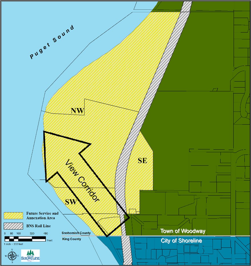
(Ord. 908 § 1 (Exh. A), 2020).
20.94.035 Parking.
A. Development in the PA 4 zone shall comply with the following parking ratios:
|
Use |
Minimum Spaces Required |
|---|---|
|
Single-family detached/attached/townhouse |
2.0 per dwelling unit |
|
Apartment/multifamily: |
|
|
Studio and one-bedroom units |
0.75 per dwelling unit |
|
Two-bedroom or more units |
1.5 per dwelling unit |
|
Accessory dwelling units |
1.0 per dwelling unit |
|
Home occupation |
In addition to required parking for the dwelling unit, 1 for any nonresident employed by the home occupation and 1 for patrons when services are rendered on site |
|
Assisted living facilities |
1 per 3 dwelling or sleeping units |
|
Restaurants |
1 per 75 square feet in dining or lounge area |
|
Hotel/motel |
1 per unit |
|
Conference center |
1 per 3 fixed seats, plus 1 per 50 square feet used for assembly purposes without fixed seats, or 1 per bedroom, whichever results in the greater number of spaces |
|
Retail trade uses |
1 per 400 square feet |
|
Professional office uses |
1 per 500 square feet |
|
Recreation/culture |
1 per 300 square feet |
|
Parks and trails and public access to shorelines |
Parking analysis |
|
General services uses |
1 per 300 square feet |
|
Health and fitness facilities |
1 per 300 square feet |
|
Public facilities and utilities |
Parking analysis |
Note: Square feet in the table above refers to net usable area and excludes walls, corridors, lobbies, bathrooms, etc.
B. If the formula for determining the number of parking spaces results in a fraction, the number of parking spaces shall be rounded to the nearest whole number, with fractions of one-half or greater rounding up and fractions below one-half rounding down.
C. Uses not listed, or uses listed with a parking ratio referring to “parking analysis” in Table 20.94.035A shall undergo a parking demand analysis prepared by a qualified professional with expertise in parking demand studies. The parking demand study shall be reviewed and approved concurrently with a development agreement.
D. Public parking areas shall be distributed throughout the project and provided at a rate appropriate to serve publicly accessible recreation and open space areas.
E. An applicant may request a reduction of the minimum required parking spaces with the approval of a parking management plan. The parking management plan shall be reviewed and approved concurrently with a development agreement.
F. Development in the PA 4 zone shall comply with SMC 20.50.410, Parking design standards; SMC 20.50.420, Vehicle access and circulation – Standards; and SMC 20.50.440, Bicycle facilities – Standards. (Ord. 908 § 1 (Exh. A), 2020).
20.94.040 Recreation and open space.
A. Development in the PA 4 zone shall provide an integrated public open space network that links together the various open spaces throughout the development and provides public access to shorelines, public open space areas, and publicly accessible parking.
B. All development shall provide public recreation and open space at a minimum rate of 10 percent of the gross site area. The minimum public recreation and open space area shall not include, and shall be in addition to, shoreline public access as required pursuant to the Shoreline Management Act, Chapter 90.58 RCW.
C. Public recreation and open space areas shall include a mix of active and passive uses.
D. For developments with an approved phasing plan, each phase of a development shall include a minimum of 10 percent of the gross recreation and open space area required for the phase. (Ord. 908 § 1 (Exh. A), 2020).
20.94.045 Transportation.
A transportation study shall be prepared and submitted with the application for a development agreement. The scope of the transportation study shall be established by the City Traffic Engineer and include at a minimum the following elements:
A. Development within Point Wells shall comply with the following traffic restrictions:
1. Richmond Beach Drive shall be limited to 4,000 average daily trips (ADT); and
2. The Richmond Beach Road Corridor shall not exceed a level of service (LOS) D with nine-tenths volume-to-capacity (V/C) ratio.
B. Any combination of residential or commercial development or redevelopment that would generate 250 or more average daily trips shall provide a general-purpose public access road wholly within the Town of Woodway that connects into Woodway’s transportation network and provides a full second vehicular access point from Point Wells into Woodway. The average daily trips shall be counted cumulatively for all development in the entire PA 4 zone.
C. Connectivity. Development in the PA 4 zone shall provide a network of streets, sidewalks, and multipurpose pathways that are well connected and provide efficient circulation throughout the zone and connect to the surrounding transportation network.
D. Public and Private Street Cross-Sections. Street cross-sections shall be developed to complement adjoining land uses and implement applicable design standards while also meeting engineering standards for safety and function, and the most recently adopted City of Shoreline Engineering Development Manual. Cross-sections for each type of street within the development shall be reviewed and approved concurrently with a development agreement. The table below describes the primary elements for types of streets anticipated within a development.
|
Feature |
Primary Street |
Secondary Street |
|---|---|---|
|
Sidewalk |
12' |
7' |
|
Amenity Zone |
5' |
5' |
|
Landscaping |
Street trees 30' on center |
Street trees 30' on center |
|
On-Street Parking |
Yes (both sides) |
Yes (one side) |
|
General Purpose Lane |
11' max. lane width |
10.5' max. lane width |
|
Right-of-Way Minimum |
60' – 70' |
52.5' |
Figure 20.94.045A – Primary Street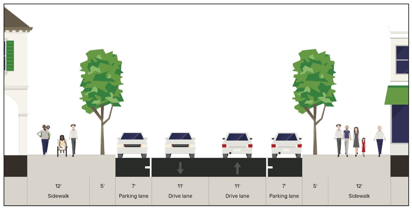
Figure 20.94.045B – Secondary Street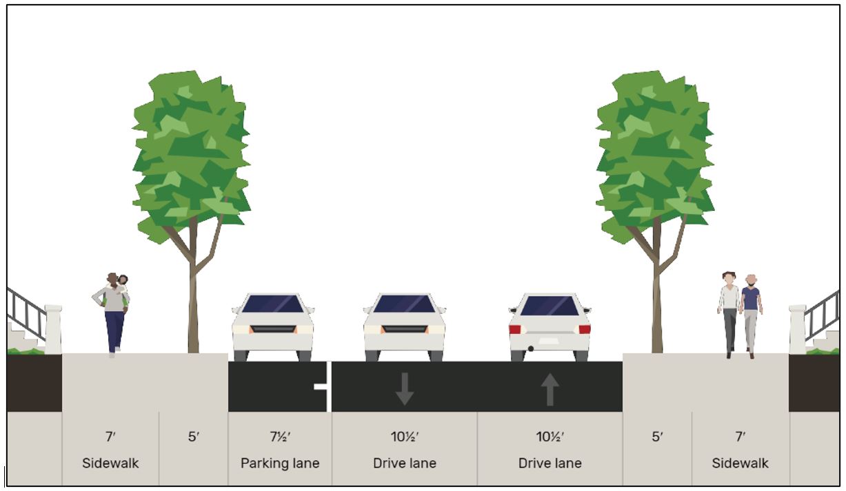
(Ord. 908 § 1 (Exh. A), 2020).
20.94.050 Design standards.
Development in the PA 4 zone other than single-family detached homes is subject to Chapter 20.50 SMC, Subchapter 3, Single-Family Attached Residential Design, or Subchapter 4, Commercial and Multifamily Zone Design. (Ord. 908 § 1 (Exh. A), 2020).
20.94.055 Landscaping.
Landscaping shall be provided throughout the site and integrated as part of the overall project design. Landscaping shall be provided on the perimeter of the site adjacent to existing development. A development-wide conceptual landscape plan identifying landscape locations, dimensions, and type shall be reviewed and approved with the development agreement. (Ord. 908 § 1 (Exh. A), 2020).
20.94.060 Signs.
Signs within the PA 4 zone shall comply with Chapter 20.50 SMC, Subchapter 8, Signs. (Ord. 908 § 1 (Exh. A), 2020).
20.94.065 Sustainability.
Development in the PA 4 zone shall meet or exceed Tier 4 of the Deep Green development standards, as defined in Chapter 20.50 SMC, Subchapter 9, Deep Green Incentive Program. (Ord. 908 § 1 (Exh. A), 2020).
20.94.070 Outdoor lighting.
A. In addition to the lighting standards in SMC 20.50.115 and the lighting requirements in the design standards, outdoor lighting shall be located and designed to eliminate light pollution by meeting the following:
1. Fixtures shall contain shielding and/or direct cut-off lighting;
2. Fixtures shall be no brighter than necessary to light the intended area;
3. Color temperatures shall minimize blue light emissions to the extent feasible;
4. Timers, dimmers, motion sensors or other adaptive control methods shall be utilized where feasible to turn off lighting when unnecessary; and
5. Up-lighting shall be limited to accent features, landscaping, and State or Federal flags. (Ord. 908 § 1 (Exh. A), 2020).
20.94.075 Tree preservation and management.
Development in the PA 4 zone shall comply with Chapter 20.50 SMC, Subchapter 5, Tree Conservation, Land Clearing and Site Grading Standards. (Ord. 908 § 1 (Exh. A), 2020).
20.94.080 Neighborhood meeting.
A. The applicant shall conduct a neighborhood meeting to discuss the proposed development. The meeting must be held at least 30 days prior to submitting a development agreement application.
B. The purpose of the neighborhood meeting is to:
1. Ensure the applicant pursues early and effective public participation in conjunction with the proposal, giving the applicant an opportunity to understand and mitigate any real and perceived impacts the proposed development might have to the neighborhood or neighboring cities;
2. Ensure that residents, property owners, business owners, and nearby cities have an opportunity at an early stage to learn about how the proposed development might affect them and to work with the applicant to resolve concerns prior to submittal of a development application.
C. The neighborhood meeting shall meet the following requirements:
1. Notice of the neighborhood meeting shall be provided by the applicant and shall include the date, time and location of the neighborhood meeting and a description of the project, zoning of the property, site and vicinity maps, the land use applications that may be required, and the name and contact information of the applicant or representative of the applicant to contact for additional information.
2. The notice shall be provided at a minimum to property owners located within 1,000 feet of the proposal, the neighborhood chair as identified by the Shoreline Office of Neighborhoods (note: if a proposed development is within 500 feet of adjacent neighborhoods, those chairs shall also be notified), any city or town whose municipal boundaries are within one mile of the subject property, and to the Department.
3. The notice shall be postmarked 10 to 14 days prior to the neighborhood meeting.
4. The neighborhood meeting shall be held within the City limits of Shoreline.
5. The neighborhood meeting shall be held anytime between the hours of 5:30 p.m. and 9:30 p.m. on weekdays or anytime between the hours of 9:00 a.m. and 9:00 p.m. on weekends.
D. The neighborhood meeting agenda shall cover the following items:
1. Introduction of neighborhood meeting organizer (i.e., developer, property owner, etc.);
2. Description of proposed project that includes proposed mix of land uses including the number of dwelling units and amount of nonresidential square footage, number of parking spaces, and location and amount of open space;
3. Listing of permits that are anticipated for the project;
4. Description of how comments made at the neighborhood meeting will be used;
5. Provide meeting attendees with the City’s contact information;
6. Provide a sign-up sheet for attendees.
E. The applicant shall provide to the City a written summary of the neighborhood meeting to be included with the development application. The summary shall include the following:
1. A copy of the mailed notice of the neighborhood meeting with a list to whom it was mailed;
2. A list of persons who attended the meeting and their addresses;
3. A summary of concerns, issues, and problems expressed during the meeting. (Ord. 908 § 1 (Exh. A), 2020).
20.94.085 Review process.
A. A development agreement, pursuant to RCW 36.70B.170 is required for any new development in the PA 4 zone and shall set forth the development standards, conditions, and other provisions that shall apply to govern and vest the development, use, and mitigation of the development. For the purposes of this section, “development standards” includes, but is not limited to:
1. Project elements such as permitted uses, residential densities, and nonresidential densities and intensities or building sizes;
2. The amount and payment of impact fees imposed or agreed to in accordance with any applicable provisions of State law, any reimbursement provisions, other financial contributions by the property owner, inspection fees, or dedications;
3. Mitigation measures, development conditions, and other requirements under Chapter 43.21C RCW;
4. Design standards such as building massing, architectural elements, maximum heights, setbacks, conceptual street and streetscapes, drainage and water quality requirements, palette of potential building materials, conceptual lighting, landscaping, and other development features;
5. Affordable housing units;
6. Park development and open space preservation;
7. Phasing of development;
8. Review procedures and standards for implementing decisions;
9. A build-out or vesting period for applicable standards;
10. Any other appropriate development requirement or procedure;
11. Preservation of significant trees; and
12. Connecting, establishing, and improving nonmotorized access.
B. The City Council shall review the development agreement and may approve, or approve within conditions, the development agreement when all of the following are met:
1. The proposed development is consistent with the goals and policies of the Comprehensive Plan as well as the goals and policies of the Point Wells Subarea Plan.
2. The proposed development is consistent with the goals, policies, and regulations of the City’s Shoreline Master Program.
3. There is either sufficient capacity and infrastructure (e.g., roads, sidewalks, bike lanes) that meet the City’s adopted level of service standards (as confirmed by the performance of a transportation impact analysis) in the transportation system (motorized and nonmotorized) to safely support the development proposed in all future phases, or there will be adequate capacity and infrastructure by the time each phase of development is completed. If capacity or infrastructure must be increased to support the proposed development agreement, the applicant must identify a plan for funding their proportionate share of the improvements.
4. There is either sufficient capacity within public services such as water, sewer and stormwater to adequately serve the development proposal in all future phases, or there will be adequate capacity available by the time each phase of development is completed. If capacity must be increased to support the proposed development agreement, then the applicant must identify a plan for funding their proportionate share of the improvements.
5. The development demonstrates high quality design elements consistent with the City’s applicable design standards as referenced in Chapter 20.50 SMC, Subchapters 2 through 4.
C. Development Agreement Approval Procedures. The City Council may approve development agreements through the following procedure:
1. A development agreement application incorporating the elements stated in subsection B of this section may be submitted by a property owner with any additional related information as determined by the Director. After staff review and SEPA compliance, the Planning Commission shall conduct a public hearing on the application. The Planning Commission shall then make a recommendation to the City Council pursuant to the criteria set forth in subsection B of this section and the applicable goals and policies of the Comprehensive Plan. The City Council shall approve, approve with additional conditions, or deny the development agreement by ordinance or resolution;
2. Recorded Development Agreement. Upon City Council approval of a development agreement under the procedure set forth in this subsection C, the property owner shall execute and record the development agreement with the Snohomish County Auditor’s Office to run with the land and bind and govern development of the property.
D. Consultation on Land Use Permit Applications. The City shall provide the Town of Woodway written notice of all land use permit applications in the PA 4 zone within 30 days of permit application, consistent with Chapter 36.70B RCW, Local Project Review. Staff from the Town of Woodway shall be invited to attend meetings between Shoreline staff and the applicant relating to such permit applications, pre-application meetings, and shall be provided an opportunity to review and comment. (Ord. 908 § 1 (Exh. A), 2020).
20.94.090 Amendments to regulations and standards.
The City of Shoreline shall provide the Town of Woodway with at least 30 calendar days written notice (unless otherwise agreed to or waived in writing), and a review and comment opportunity, before any legislative actions that may modify or amend the PA 4 development regulations, or that otherwise impacts the uses, development, or redevelopment of the Point Wells area. Notice shall include, but not be limited to, notice of all Planning Commission and City Council meetings and hearings related to such legislative considerations or actions. (Ord. 908 § 1 (Exh. A), 2020).