


Chapter 14.08
SHORELINE REGULATIONS
Sections:
Article I. Authority and Purpose
14.08.040 Relationship to other codes, ordinances and plans.
14.08.050 Liberal construction.
Article II. Environment Designations
14.08.100 Environment designations.
14.08.140 Public recreation conservancy.
14.08.150 Shoreline residential.
14.08.160 Shoreline residential – Low intensity.
Article III. General Regulations
14.08.200 Shoreline use and modification.
14.08.210 Development standards.
14.08.220 Archaeological and historic resources.
14.08.230 Environmental protection.
14.08.240 Shoreline vegetation conservation.
14.08.250 Water quality, stormwater, and nonpoint pollution.
Article IV. Shoreline Modifications and Uses Regulations
14.08.310 Commercial development.
14.08.330 Dredging and dredge material disposal.
14.08.340 Fill and excavation.
14.08.370 Recreational development.
14.08.380 Residential development.
14.08.390 Shoreline habitat and natural systems enhancement projects.
14.08.400 Shoreline stabilization.
14.08.410 Transportation – Trails, roads, and parking.
Article V. Critical Areas
14.08.500 Authority, chapter and procedures.
14.08.510 Purpose – Goals – Policies.
14.08.520 Applicability and critical areas map.
14.08.550 Critical area – Critical aquifer recharge areas.
14.08.560 Critical area – Fish and wildlife habitat conservation areas.
14.08.570 Critical area – Frequently flooded areas.
14.08.580 Critical area – Geologically hazardous areas.
14.08.590 Critical area – Wetlands.
14.08.600 Most current scientific and technical information.
14.08.610 Development standards.
14.08.630 Bonds to ensure mitigation, maintenance, and monitoring.
14.08.640 Critical area inspections.
Article VI. Existing Uses, Structures and Lots
14.08.720 Nonconforming structures.
Article VII. Administration and Enforcement
14.08.800 Roles and responsibilities.
14.08.820 Statutory noticing requirements.
14.08.830 Application requirements.
14.08.840 Shoreline substantial development permits.
14.08.850 Shoreline conditional use permits.
14.08.860 Shoreline variance permits.
14.08.870 Exemptions from shoreline substantial development permits.
14.08.880 Duration of permits.
14.08.890 Initiation of development.
14.08.920 Amendments to permits.
14.08.940 Cumulative effects of shoreline developments.
14.08.950 Amendments to shoreline master program.
14.08.970 Shoreline environment designation map.
Article I. Authority and Purpose
14.08.010 Authority.
The Shoreline Management Act (SMA) of 1971, Chapter 90.58 RCW, is the authority for the enactment and administration of this shoreline master program (SMP). (Ord. 1338 § 2 (Exh. 1), 2023; Ord. 1194 § 2, 2014).
14.08.020 Applicability.
A. This SMP applies to all development, the construction or exterior alteration of structures; dredging; drilling; dumping; filling; removal of any sand, gravel, minerals or vegetation; bulkheading; driving of piling; placing of obstructions; or any project of a permanent or temporary nature which interferes with the normal public use of the surface of the waters of the state subject to Chapter 90.58 RCW at any stage of water level. Development does not include the following activities:
1. Soap Lake management and water management operations related to lake levels and water quality that do not meet the definition of development as provided above;
2. Interior building improvements;
3. Exterior structure maintenance activities, including painting and roofing, as long as it does not expand the existing footprint of the structure;
4. Routine landscape maintenance of established, ornamental landscaping, such as lawn mowing, pruning and weeding;
5. Maintenance of the following existing facilities that does not expand the affected area: septic tanks (routine cleaning), wells, and individual utility service connections;
6. Dismantling or removing structures if there is no other associated development or redevelopment;
7. Pursuant to RCW 90.58.355, any person conducting a remedial action at a facility pursuant to a consent decree, order, or agreed order issued pursuant to Chapter 70.305 RCW, or to Ecology when it conducts a remedial action under Chapter 70.305 RCW;
8. Pursuant to RCW 90.58.355, any person installing site improvements for stormwater treatment in an existing boatyard facility to meet requirements of a National Pollutant Discharge Elimination System stormwater general permit;
9. Washington State Department of Transportation projects and activities meeting the conditions of RCW 90.58.356;
10. Projects consistent with an environmental excellence program agreement pursuant to Chapter 43.21K RCW and RCW 90.58.045;
11. Projects authorized through the Energy Facility Site Evaluation Council process, pursuant to Chapter 80.50 RCW; and
12. Areas and uses in those areas that are under exclusive federal jurisdiction as established through federal or state statutes are not subject to the jurisdiction of Chapter 90.58 RCW.
B. This program shall apply to all of the shorelands and waters within the city of Soap Lake as described in the city’s SMP Section I, Profile of the Shoreline Jurisdiction within the City of Soap Lake.
C. All proposed uses, activities, or development occurring within shoreline jurisdiction must conform to the intent and requirements of Chapter 90.58 RCW, the SMA, and this SMP whether or not a permit or other form of authorization is required, except when specifically exempted by statute. See the city’s SMP Section I for the shoreline jurisdiction description and SLMC 14.08.960 for the definition of uses, activities, and development.
D. The SMP applies to shoreline jurisdiction within the city limits.
E. Pursuant to WAC 173-27-060, federal agency activities may be required by other federal laws to meet the permitting requirements of Chapter 90.58 RCW. This program shall apply to all nonfederal developments and uses undertaken on federal lands and on lands subject to nonfederal ownership, lease or easement, even though such lands may fall within the external boundaries of a federal ownership.
F. As recognized by RCW 90.58.350, the provisions of this SMP shall not affect treaty rights of Indian nations or tribes.
G. Maps indicating the extent of shoreline jurisdiction and shoreline designations are guidance only. They are to be used in conjunction with best available science, field investigations and on-site surveys to accurately establish the location and extent of shoreline jurisdiction when a project is proposed. All areas meeting the definition of a shoreline of the state or a shoreline of statewide significance, whether mapped or not, are subject to the provisions of this program. (Ord. 1338 § 2 (Exh. 1), 2023; Ord. 1194 § 2, 2014).
14.08.030 Purpose.
A. The purposes of this SMP are:
1. To promote the public health, safety, and general welfare of the city by providing comprehensive policies and effective, reasonable regulations for development, use and protection of jurisdictional shorelines; and
2. To further assume and carry out the local government responsibilities established by the SMA in RCW 90.58.050 including planning and administering the regulatory program consistent with the policy and provisions of the SMA in RCW 90.58.020; and
3. To provide a high quality shoreline environment where:
a. Recreational opportunities are abundant;
b. The public enjoys access to and views of shoreline areas;
c. Natural systems are preserved, restored or enhanced;
d. Ecological functions of the shoreline are maintained and improved over time; and
e. Water-oriented uses are promoted consistent with the shoreline character and environmental functions.
4. To apply special conditions to those uses which are not consistent with the control of pollution and prevention of damage to the natural environment or are not unique to or dependent upon use of the state’s shoreline; and
5. To ensure no net loss of ecological functions associated with the shoreline. (Ord. 1338 § 2 (Exh. 1), 2023; Ord. 1194 § 2, 2014).
14.08.040 Relationship to other codes, ordinances and plans.
A. All applicable federal, state, and local laws shall apply to properties in the shoreline jurisdiction. Where this program makes reference to any RCW, WAC, or other state or federal law or regulation the most recent amendment or current edition shall apply.
B. In the event provisions of this SMP conflict with provisions of federal, state or city regulations, the provision that is most protective of shoreline resources shall prevail. It is understood that the provisions of this chapter may not allow development to occur at what otherwise might be the property’s full zoning potential.
C. The policies in the SMP, contained in the shoreline master program elements, state the underlying objectives the regulations are intended to accomplish. The policies guide the interpretation and enforcement of the SMP regulations contained in this chapter. The policies are not regulations in themselves and, therefore, do not impose requirements beyond those set forth in the regulations.
D. This shoreline master program contains critical area regulations in Article V of this chapter. Critical area regulations are applicable only in shoreline jurisdiction. They provide a level of protection to critical areas and ensure no net loss of shoreline ecological functions necessary to sustain shoreline natural resources (RCW 36.70A.480).
E. Projects in the shoreline jurisdiction that have either been deemed technically complete through the application process or have been approved through local and state reviews prior to the adoption of this program are considered accepted. Major changes or new phases of projects that were not included in the originally approved plan will be subject to the policies and regulations of this program.
F. The SMP is intended to align with and support Resolution No. 2016-848, a resolution adopting the lake liaison committee recommendations, which outlines the values, vision, mission and actions to protect, preserve and restore the lake in partnership with the city of Soap Lake through formation of a liaison committee.
G. The mineral waters of Soap Lake meet the eligibility criteria for the outstanding resource water state designation through the Washington Department of Ecology. Pending regulatory rule adoption, this may carry specific restrictions associated with activities that may pollute or otherwise degrade the lake.
H. Soap Lake’s shoreline is uniquely influenced by the U.S. Bureau of Reclamation’s 1976 transfer contract titled “Transfer Report and Report of Joint Inspection in Connection with the Transfer of Operation and Maintenance Responsibilities of Bureau Constructed Works, Special Reserved Works (Quincy District) to the QCBID.” Through agreement, the U.S. Bureau of Reclamation controls the lake elevation as measured from the 1,078-foot mean sea level (MSL) elevation, as recorded in the U.S. Bureau of Reclamation 400 scale topography 22N R27E map, dated May 26, 1936. (Ord. 1338 § 2 (Exh. 1), 2023; Ord. 1194 § 2, 2014).
14.08.050 Liberal construction.
As provided for in RCW 90.58.900, the SMA is exempted from the rule of strict construction. The city shall therefore interpret the SMP not only on the basis of actual words and phrases used in it, but by also taking purposes, goals, and policies into account. (Ord. 1338 § 2 (Exh. 1), 2023; Ord. 1194 § 2, 2014).
14.08.060 Severability.
Should any section or provision of this SMP be declared invalid, such decision shall not affect the validity of this SMP as a whole. (Ord. 1338 § 2 (Exh. 1), 2023; Ord. 1194 § 2, 2014).
14.08.070 Effective date.
The SMP is hereby adopted on July 5, 2023. This SMP and all amendments thereto shall become effective 14 days after final approval and adoption by Ecology. (Ord. 1338 § 2 (Exh. 1), 2023; Ord. 1194 § 2, 2014).
Article II. Environment Designations
14.08.100 Environment designations.
A. The city has designated shorelines pursuant to Chapter 90.58 RCW by defining them, providing criteria for their identification and establishing the shoreline ecological functions to be protected. Project proponents are responsible for determining whether a shoreline exists and is regulated pursuant to this program. The SMP classifies the city of Soap Lake’s shoreline into six shoreline environment designations consistent with the purpose and designation criteria as follows:
1. Aquatic;
2. Urban conservancy;
3. Recreation;
4. Public recreation conservancy;
5. Shoreline residential;
6. Shoreline residential – Low intensity.
B. Official Shoreline Maps.
1. Shoreline area designations are delineated on a map, hereby incorporated as a part of this program (SLMC 14.08.970) that shall be known as the official shoreline map. The purpose of the official shoreline map is to identify shoreline area designations. Maps indicating the extent of shoreline jurisdiction and shoreline designations are guidance only. They are to be used in conjunction with best available science, field investigations and on-site surveys to accurately establish the location and extent of shoreline jurisdiction when a project is proposed.
C. Unmapped or Undesignated Shorelines.
1. All areas meeting the definition of a shoreline of the state or a shoreline of statewide significance, whether mapped or not, are subject to the provisions of this program.
D. Interpretation of Environment Designation Boundaries.
1. Whenever existing physical features are inconsistent with boundaries on the official shoreline map, the shoreline administrator shall interpret the boundaries. Appeals of such interpretations may be filed pursuant to SLMC 14.08.910, Appeals.
2. All shoreline areas waterward of the OHWM shall be designated aquatic.
3. Only one shoreline area designation shall apply to a given shoreland area.
4. All areas within shorelines that are not mapped and/or designated are automatically assigned urban conservancy designation. (Ord. 1338 § 2 (Exh. 1), 2023; Ord. 1194 § 2, 2014).
14.08.110 Aquatic.
A. Purpose.
1. The purpose of the “aquatic” shoreline designation is to protect, restore, and manage the unique characteristics and resources of the areas waterward of the OHWM.
B. Designation Criteria.
1. An aquatic shoreline designation is assigned to lands and waters waterward of the OHWM.
C. Management Policies.
1. In addition to the other applicable policies and regulations of this program, the following management policies shall apply:
a. New overwater structures should be allowed only for water-dependent uses, public access, recreation, or ecological restoration.
b. Shoreline uses and modifications should be designed and managed to prevent degradation of water quality and natural hydrographic conditions.
c. In-water uses should be allowed where impacts can be mitigated to ensure no net loss of shoreline ecological functions. Permitted in-water uses must be managed to avoid impacts to shoreline ecological functions. Unavoidable impacts must be minimized and mitigated.
d. On navigable waters or their beds, all uses and developments should be located and designed to:
i. Minimize interference with surface navigation;
ii. Consider impacts to public views;
iii. Allow for the safe, unobstructed passage of wildlife, particularly species dependent on migration.
e. Multiple or shared use of overwater and water access facilities should be encouraged to reduce the impacts of shoreline development and increase effective use of water resources.
f. Structures and activities permitted should be related in size, form, design, and intensity of use to those permitted in the immediately adjacent upland area. The size of new overwater structures should be limited to the minimum necessary to support the structure’s intended use.
g. Natural light should be allowed to penetrate to the extent necessary to discourage salmonid predation and to support near-shore habitat unless other illumination is required by state or federal agencies.
h. Aquaculture practices should be encouraged in those waters and beds most suitable for such use. Aquaculture should be discouraged where it would adversely affect the strength or viability of native stocks or unreasonably interfere with navigation.
i. Shoreline uses, development, activities, and modifications in the aquatic shoreline designation requiring use of adjacent landside property should be in a shoreline designation that allows that use, development, activity or modification. (Ord. 1338 § 2 (Exh. 1), 2023; Ord. 1194 § 2, 2014).
14.08.120 Urban conservancy.
A. Purpose.
1. The purpose of the urban conservancy environment is to protect and restore ecological functions of open space, fully or partially unimproved areas, floodplain and other sensitive lands where they exist in urban and developed settings, while allowing a variety of compatible uses.
B. Designation Criteria.
1. The following criteria are used to consider an urban conservancy shoreline designation:
a. The shoreline is located within the urban growth area boundary or within an unimproved area within the city limits;
b. The shoreline has moderate-to-high ecological function with moderate-to-high opportunity for preservation and low-to-moderate opportunity for restoration or low-to-moderate ecological function with moderate-to-high opportunity for restoration;
c. The shoreline has potential for public, water-oriented recreation where ecological functions can be maintained or restored; or
d. The shoreline has high scientific or educational value or unique historic or cultural resources value.
C. Management Policies.
1. In addition to the other applicable policies and regulations of this program the following management policies shall apply:
a. Allowed uses should be those that preserve the natural character of the area and/or promote preservation and restoration within critical areas and public open spaces either directly or over the long term.
b. Uses that result in restoration of ecological functions should be allowed if the use is otherwise compatible with the purpose of the environment and the setting.
c. Development, when feasible, should be designed to ensure that any necessary shoreline stabilization, flood control measures, native vegetation removal, or other shoreline modifications do not result in a net loss of shoreline ecological function or further degrade other shoreline values.
d. Public access and recreational facilities should be promoted.
e. Water-oriented uses should be given priority over nonwater-oriented uses. (Ord. 1338 § 2 (Exh. 1), 2023; Ord. 1194 § 2, 2014).
14.08.130 Recreation.
A. Purpose.
1. The purpose of the recreation environment is to provide for water-oriented recreational uses with some commercial uses to support recreational uses while protecting existing ecological functions, conserving existing natural resources, and restoring ecological functions in areas that have been previously degraded.
B. Designation Criteria.
1. The following criteria are used to consider a recreation shoreline designation:
a. The shoreline has low-to-moderate ecological function with low-to-moderate opportunity for preservation and low-to-moderate opportunity for restoration;
b. The shoreline is highly developed and most development is recreation-related with potential for additional recreation and recreation-related commerce; or is suitable and planned for water-oriented uses;
c. The shoreline is planned, platted or currently used for recreational development;
d. The shoreline has existing recreation uses or moderate-to-high potential for public and private water-oriented recreation where ecological functions can be maintained or enhanced; or
e. The shoreline has limited scientific or educational value or unique historic or cultural resources values.
C. Management Policies.
1. In addition to the other applicable policies and regulations of this program the following management policies shall apply:
a. In regulating uses in the recreation environment, first priority should be given to water-dependent recreational uses. Second priority should be given to water-related and water-enjoyment recreational uses. Nonwater-oriented uses should not be allowed except as part of mixed-use developments with a recreation focus.
b. Policies and regulations shall ensure no net loss of shoreline ecological functions as a result of new development. Consistent with the city’s restoration plan, new development shall include restoration of shoreline functions as part of project proposals.
c. Where feasible, visual and physical public access should be required and/or enhanced as provided for in SLMC 14.08.260, Public access. Recreational objectives should be enhanced by combining physical and visual public access opportunities with other recreational opportunities where feasible.
d. Water-oriented commercial uses should be allowed.
e. Aesthetic objectives should be implemented by means such as sign control regulations, appropriate development siting, screening and architectural standards, and maintenance of natural vegetative buffers. (Ord. 1338 § 2 (Exh. 1), 2023; Ord. 1194 § 2, 2014).
14.08.140 Public recreation conservancy.
A. Purpose.
1. The purpose of the public recreation conservancy shoreline designation is to provide continued and enhanced recreational opportunities while protecting shoreline ecological functions, conserve existing natural resources and valuable historic and cultural areas in order to provide for sustained resource use.
B. Designation Criteria.
1. The following criteria are used to consider a public recreation conservancy shoreline designation:
a. The shoreline is publicly owned and includes facilities and infrastructure that provide both aquatic habitat and water supply benefits;
b. The shoreline has low-to-high ecological function with moderate-to-high opportunity for preservation and low-to-moderate opportunity for restoration;
c. The shoreline is not highly developed and most development is recreation-related;
d. The shoreline is planned for or has an existing recreation use;
e. The shoreline has existing or moderate to high potential for public, water-oriented recreation where ecological functions can be maintained or restored; or
f. The shoreline has high scientific or educational value or unique historic or cultural resources value.
C. Management Policies.
1. In addition to the other applicable policies and regulations of this program the following management policies shall apply:
a. Uses in the public recreation conservancy – shoreline designation should be limited to uses that sustain the shoreline area’s physical and biological resources and do not substantially degrade shoreline ecological functions or the rural or natural character of the shoreline area.
b. Recreation development shall ensure no net loss of shoreline ecological functions and preserve the existing character of the shoreline consistent with the purpose of this designation.
c. Encourage regulations that provide adequate setbacks from the shoreline, promote native vegetation conservation and invasive species control/removal and replacement with native species, reduce the need for shoreline stabilization and maintain or improve water quality to ensure no net loss of shoreline ecological functions.
d. Water-dependent and water-enjoyment recreation facilities that do not deplete the resource over time are preferred uses, provided significant adverse impacts to the shoreline are avoided and unavoidable impacts are minimized and mitigated.
e. Developments and uses that would substantially degrade or permanently deplete the biological resources of the area should not be allowed.
f. New shoreline stabilization, vegetation removal, and other shoreline modifications should be designed and managed consistent with these guidelines to ensure that the natural shoreline functions are protected. Such shoreline modification should not be inconsistent with planning provisions for restoration of shoreline ecological functions. (Ord. 1338 § 2 (Exh. 1), 2023; Ord. 1194 § 2, 2014).
14.08.150 Shoreline residential.
A. Purpose.
1. The purpose of the shoreline residential designation is to accommodate primarily residential development and appurtenant structures, but to also allow other types of development that are consistent with this chapter. An additional purpose is to provide appropriate public access and recreational uses.
B. Designation Criteria.
1. Assign a shoreline residential environment designation to shoreline areas that are:
a. The shoreline has low-to-moderate ecological function with low-to-moderate opportunity for restoration;
b. The shoreline contains mostly residential development at urban densities and does not contain resource industries (agriculture, forestry, mining);
c. The shoreline is planned or platted for residential uses in the comprehensive plan; or
d. The shoreline has low-to-moderate potential for low impact, passive or active water-oriented recreation where ecological functions can be restored.
C. Management Policies.
1. In addition to the other applicable policies and regulations of this program the following management policies shall apply:
a. Encourage regulations that ensure no net loss of shoreline ecological functions as a result of new development such as limiting lot coverage, providing adequate setbacks from the shoreline, promoting vegetation conservation, reducing the need for shoreline stabilization and maintaining or improving water quality to ensure no net loss of ecological functions.
b. The scale and density of new uses and development should be compatible with sustaining shoreline ecological functions and processes, and the existing residential character of the area.
c. Public access and joint (rather than individual) use of recreational facilities should be promoted.
d. Access, utilities, and public services to serve proposed development within shorelines should be constructed outside shorelines to the extent feasible, and be the minimum necessary to adequately serve existing needs and planned future development.
e. Public or private outdoor recreation facilities should be provided with proposals for subdivision development and encouraged with all shoreline development if compatible with the character of the area. Priority should be given first to water-dependent and then to water-enjoyment recreation facilities.
f. Commercial development should be limited to water-oriented uses. Nonwater-oriented commercial uses should only be allowed as part of mixed-used developments. (Ord. 1338 § 2 (Exh. 1), 2023; Ord. 1194 § 2, 2014).
14.08.160 Shoreline residential – Low intensity.
A. Purpose.
1. The purpose of the shoreline residential – low intensity designation is to accommodate residential development while protecting and, where appropriate, enhancing ecological functions. An additional purpose is to provide appropriate public access and recreational uses.
B. Designation Criteria.
1. Assign a shoreline residential – low intensity environment designation to shoreline areas where:
a. The shoreline has moderate-to-high ecological function with low-to-moderate opportunity for restoration, and provides opportunity for development that is compatible with ecological protection/restoration;
b. The shoreline is planned or platted for residential uses in the comprehensive plan; or
c. The shoreline may support public passive or active water-oriented recreation with opportunity for ecological functions restoration.
C. Management Policies.
1. In addition to the other applicable policies and regulations of this program the following management policies shall apply:
a. Encourage regulations that ensure no net loss of shoreline ecological functions as a result of new development such as limiting lot coverage, providing adequate setbacks from the shoreline, promoting vegetation conservation, reducing the need for shoreline stabilization and maintaining or improving water quality to ensure no net loss of ecological functions.
b. The scale and density of new uses and development should be compatible with sustaining shoreline ecological functions and processes, and the existing residential and ecological character of the area.
c. Developments and uses that would substantially degrade or permanently deplete the biological resources of the area should not be allowed.
d. Enhancement/restoration of shoreline ecological functions should be encouraged.
e. Public access and joint (rather than individual) use of recreational facilities should be promoted.
f. Access, utilities, and public services to serve proposed development within shorelines should be constructed outside shorelines to the extent feasible, and be the minimum necessary to adequately serve existing needs and planned future development.
g. Public or private outdoor recreation facilities should be provided with proposals for subdivision development and encouraged with all shoreline development if compatible with the character of the area. Priority should be given first to water-dependent and then to water-enjoyment recreation facilities. (Ord. 1338 § 2 (Exh. 1), 2023; Ord. 1194 § 2, 2014).
Article III. General Regulations
14.08.200 Shoreline use and modification.
A. Table 14.08.200(I) indicates which shoreline activities, uses, developments and modifications may be allowed or are prohibited in shoreline jurisdiction within each shoreline environment designation. Activities, uses, developments, and modifications are classified as follows:
1. Permitted uses require a shoreline substantial development permit or a shoreline exemption.
2. Conditional uses require a shoreline conditional use permit per SLMC 14.08.850.
3. Prohibited activities, uses, developments, and modifications are not allowed and cannot be permitted through a variance or shoreline conditional use permit.
4. General Regulations, per Article III of this chapter, and Shoreline Modifications and Uses Regulations, per Article IV of this chapter, shall be considered for additional limitations.
B. Accessory uses shall be subject to the same shoreline permitting process as their primary use.
C. Where there is a conflict between the chart and the written provisions in this SMP, the written provisions shall control.
D. Authorized uses and modifications shall be allowed only in shoreline jurisdiction where the underlying zoning allows for it and are subject to the policies and regulations of this SMP.
E. A use is considered unclassified when it is not listed in Table 14.08.200(I), Shoreline Use and Modification Matrix, or in shoreline modifications and uses regulations, per Article IV of this chapter. Any proposed unclassified use may be authorized as a conditional use; provided, that the applicant can demonstrate consistency with the requirements of this master program and the requirements for conditional uses.
F. If any part of a proposed activity, use, modification or development is not eligible for exemption per SLMC 14.08.870, Exemptions from shoreline substantial development permits, then a shoreline substantial development permit or shoreline conditional use permit shall be required for the entire proposed development project.
G. When a specific use or modification extends into the aquatic environment and an abutting upland environment without clear separation (e.g., shoreline stabilization), the most restrictive permit process shall apply to that use or modification.
H. Shoreline and critical areas buffers found in Article V of this chapter apply to all uses and modifications unless stated otherwise in the regulations.
I. Shoreline Use and Modification Matrix.
|
Abbreviations A = Allowed use with Substantial Development Permit; C = Conditional Use Permit; X= Prohibited; N/A = Not Applicable; Use/Modification |
Aquatic |
Urban Conservancy |
Recreation |
Public Recreation Conservancy |
Shoreline Residential |
Shoreline Residential – Low Intensity |
|---|---|---|---|---|---|---|
|
Boating Facilities |
||||||
|
Boat launch (motorized boats) |
A |
X |
A |
A |
C |
C |
|
Boat launch (nonmotorized boat – canoe/kayak) |
A |
A |
A |
A |
A |
A |
|
Commercial Development |
||||||
|
Water-dependent |
A |
C |
A |
A |
A |
X |
|
Water-related, water enjoyment |
X |
X |
A |
C |
X |
X |
|
Nonwater-oriented |
X |
X |
C1 |
X |
X |
X |
|
Docks, piers, mooring facilities |
A |
C |
A |
A |
A |
C |
|
Dredging Activities |
||||||
|
Dredging |
X |
N/A |
N/A |
N/A |
N/A |
N/A |
|
Dredge material disposal |
X |
X |
X |
X |
X |
X |
|
Dredging and disposal as part of ecological restoration/enhancement |
A |
A |
A |
A |
A |
A |
|
Fill and Excavation |
|
|
|
|
|
|
|
Waterward of OHWM |
C |
N/A |
N/A |
N/A |
N/A |
N/A |
|
Other upland fill and excavation |
N/A |
A |
A |
A |
A |
A |
|
In-Water Modifications |
||||||
|
Groins and weirs |
C |
C |
C |
C |
C |
C |
|
Mining |
X |
X |
X |
X |
X |
X |
|
Recreational Development |
||||||
|
Water-dependent |
A |
A |
A |
A |
A |
A |
|
Water-related/enjoyment (trails, accessory buildings) |
C |
A |
A |
A |
A |
A |
|
Nonwater-oriented |
X |
C |
C |
C |
C |
C |
|
Residential development |
X |
X |
X |
X |
A |
A |
|
Shoreline habitat and natural systems enhancement projects |
A |
A |
A |
A |
A |
A |
|
Shoreline Stabilization |
||||||
|
New |
|
|
|
|
|
|
|
Hard |
C |
C |
C |
C |
C |
C |
|
Soft |
A |
A |
A |
A |
A |
A |
|
Replacement |
A |
A |
A |
A |
A |
A |
|
Transportation |
||||||
|
Highways, arterials, railroads (parallel to OHWM) |
C |
A |
A |
A |
A |
A |
|
Secondary/public access roads (parallel to OHWM) |
X |
A |
A |
A |
A |
A |
|
Roads perpendicular to the OHWM |
X |
A |
A |
A |
A |
A |
|
Bridges (perpendicular to shoreline) |
C |
C |
A |
C |
C |
C |
|
Existing bridges, trails, roads, and parking facilities: improvement or expansion |
A |
A |
A |
A |
A |
A |
|
New parking, accessory2 |
Permitted under the primary use permit process |
|||||
|
New parking, primary |
X |
C |
C |
C |
X |
X |
|
Utility |
|
|
|
|
|
|
|
Above and underground utilities (parallel or cross shoreline) |
C |
A |
A |
A |
A |
A |
1 Allowed as part of mixed-use development.
2 Not allowed within 50 feet of edge of riparian vegetation corridor.
(Ord. 1338 § 2 (Exh. 1), 2023; Ord. 1194 § 2, 2014).
14.08.210 Development standards.
A. To preserve the existing and planned character of the shoreline consistent with the purposes of the shoreline environment designations, development standards are provided in Table 14.08.210(A). These standards apply to all use and modification unless indicated otherwise. In addition, shoreline developments shall comply with all other dimensional requirements of the city of Soap Lake Municipal Code.
|
|
Aquatic |
Urban Conservancy |
Recreation |
Public Recreation Conservancy |
Shoreline Residential |
Shoreline Residential – Low Intensity |
|---|---|---|---|---|---|---|
|
Building height: maximum in feet (according to SLMC 14.08.210(C)) |
15 |
18 |
||||
|
Impervious surface cover (in percentage) |
N/A |
10 |
20 |
10 |
30 |
25 |
|
Riparian buffer width (in feet)1, 2 |
N/A |
75 |
50 |
75 |
50 |
75 |
|
Trail width (in feet) |
N/A |
Public access easements for public trails shall have a minimum width of 10 feet; trails on private properties and not open for public use shall be up to 5 feet wide or as required by Americans with Disabilities Act (ADA) regulations. |
||||
1 Measured from the ordinary high water mark at the time of development application.
2 Accompanied by other critical area protections, and stormwater management measures, as applicable.
B. When a development or use is proposed that does not comply with the dimensional performance standards of this SMP not otherwise allowed by administrative reduction or administrative modification, such development or use can only be authorized by approval of a shoreline variance.
C. No permit shall be issued for any new or expanded building or structure of more than 18 feet above average grade level on shorelines of the state that will obstruct the view of a substantial number of residences on areas adjoining such shorelines, except where the SMP does not prohibit the same, and then only when overriding considerations of the public interest will be served. (Ord. 1338 § 2 (Exh. 1), 2023; Ord. 1194 § 2, 2014).
14.08.220 Archaeological and historic resources.
A. In all developments, whenever an archaeological area or historic site is discovered by a development in the shoreline area, the developer shall immediately stop the work and notify the city of Soap Lake, and the Department of Archaeology and Historic Preservation and affected Indian tribes.
B. Upon receipt of application for a shoreline permit or request for a statement of exemption for development on properties within 500 feet of a site known to contain a historic, cultural or archaeological resource, or upon findings as described in subsection (A) of this section, the city shall require a cultural resource site assessment; provided, that the provisions of this section may be waived if the shoreline administrator determines that the proposed development activities do not include any ground-disturbing activities and will not impact a known historic, cultural or archaeological site. The site assessment shall be conducted by a professional archaeologist or historic preservation professional, as applicable, to determine the presence of significant historic or archaeological resources. The fee for the services of the professional archaeologist or historic preservation professional shall be paid by the landowner or responsible party. The applicant shall submit a minimum of five copies of the site assessment to the shoreline administrator for distribution to the applicable parties for review.
C. If the cultural resource site assessment identifies the presence of significant historic or archaeological resources, a cultural resource management plan (CRMP) shall be prepared by a professional archaeologist or historic preservation professional, as applicable. The fee for the services of the professional archaeologist or historic preservation professional shall be paid by the landowner or responsible party. In the preparation of such plans, the professional archaeologist or historic preservation professional shall solicit comments from the Washington State Department of Archaeology and Historic Preservation, and the local tribes. (Ord. 1338 § 2 (Exh. 1), 2023; Ord. 1194 § 2, 2014).
14.08.230 Environmental protection.
A. All project proposals, including those for which a shoreline substantial development permit is not required, shall comply with Chapter 43.21C RCW, the Washington State Environmental Policy Act.
B. Applicants shall apply the following sequence of steps in order of priority to avoid or minimize significant adverse effects and significant ecological impacts, with subsection (B)(1) of this section being top priority:
1. Avoiding the adverse impact altogether by not taking a certain action or parts of an action;
2. Minimizing adverse impacts by limiting the degree or magnitude of the action and its implementation by using appropriate technology or by taking affirmative steps to avoid or reduce impacts;
3. Rectifying the adverse impact by repairing, rehabilitating, or restoring the affected environment to the conditions existing at the time of the initiation of the project;
4. Reducing or eliminating the adverse impact over time by preservation and maintenance operations;
5. Compensating for the adverse impact by replacing, enhancing, or providing substitute resources or environments; and
6. Monitoring the adverse impact and the compensation projects and taking appropriate corrective measures.
C. Projects that cause significant adverse environmental impacts, as defined in WAC 197-11-794 and the definitions section of this SMP, are not allowed unless mitigated according to subsection (B) of this section, to avoid reduction or damage to ecosystem-wide processes and ecological functions. As part of this analysis, the applicant shall evaluate whether the project may adversely affect existing hydrologic connections between streams and wetlands, and either modify the project or mitigate any impacts as needed.
D. When compensatory measures are appropriate pursuant to the mitigation priority sequence above, preferential consideration shall be given to measures that replace the adversely impacted functions directly and in the immediate vicinity of the adverse impact. However, alternative compensatory mitigation may be authorized within the affected drainage area or watershed that addresses limiting factors or identified critical needs for shoreline resource conservation based on watershed or comprehensive resource management plans, including the shoreline restoration plan, applicable to the area of adverse impact may be authorized. Authorization of compensatory mitigation measures may require appropriate safeguards, terms or conditions as necessary to ensure no net loss of ecological functions. (Ord. 1338 § 2 (Exh. 1), 2023; Ord. 1194 § 2, 2014).
14.08.240 Shoreline vegetation conservation.
A. Vegetation conservation standards shall not apply retroactively to existing uses and developments. Vegetation associated with existing structures, uses and developments may be maintained within shoreline jurisdiction as stipulated in the approval documents for the development.
B. Regulations specifying establishment and management of shoreline buffers are located in Article V, Critical Areas, of this chapter. Vegetation within shoreline buffers, and wetlands and wetland buffers shall be managed consistent with Article V, Critical Areas, of this chapter.
C. Vegetation outside of riparian buffers, and wetlands and wetland buffers and within shoreline jurisdiction shall be managed according to SLMC 14.08.230, Environmental protection, and any other regulations specific to vegetation management contained in other chapters of this SMP.
D. Vegetation clearing outside of riparian and wetlands and associated buffers shall be limited to the minimum necessary to accommodate approved shoreline development that is consistent with all other provisions of this SMP. Mitigation sequencing shall be applied so that the design and location of the structure or development minimizes native vegetation removal. Selective pruning of trees for safety and view protection is allowed. (Ord. 1338 § 2 (Exh. 1), 2023; Ord. 1194 § 2, 2014).
14.08.250 Water quality, stormwater, and nonpoint pollution.
A. The location, design, construction, and management of all shoreline uses and activities shall protect the quality and quantity of surface and groundwater adjacent to the site.
B. When applicable, all shoreline development should comply with the applicable requirements of the latest version of the Washington State Department of Ecology’s (Ecology) Stormwater Management Manual for Eastern Washington.
C. Potentially harmful materials, including but not limited to oil, chemicals, tires, or hazardous materials, shall not be allowed to enter any body of water or wetland, or to be discharged onto the land. Potentially harmful materials shall be maintained in safe and leak-proof containers.
D. Herbicides, fungicides, fertilizers, and pesticides shall not be applied within 25 feet of a water body, except by a qualified professional in accordance with state and federal laws.
E. New development shall provide stormwater management facilities designed, constructed, and maintained in accordance with the latest version of the Washington State Department of Ecology’s (Ecology) Stormwater Management Manual for Eastern Washington, including the use of BMPs. Additionally, new development shall implement low impact development techniques where feasible and necessary to fully implement the core elements of the surface water design manual.
F. For development activities with the potential for adverse impacts on water quality or quantity in a fish and wildlife habitat conservation area, a critical area report as prescribed in Article V, Critical Areas, shall be prepared. Such reports should discuss the project’s potential to exacerbate water quality parameters which are impaired and for which total maximum daily loads (TMDLs) for that pollutant have been established, and prescribe any necessary mitigation and monitoring.
G. All materials that may come in contact with water shall be constructed of materials, such as untreated wood, concrete, approved plastic composites or steel, that will not adversely affect water quality or aquatic plants or animals. Materials used for decking or other structural components shall be approved by applicable state agencies for contact with water to avoid discharge of pollutants from wave splash, rain, or runoff. Wood treated with creosote, copper chromium arsenic, or pentachlorophenol is prohibited in shoreline waterbodies. (Ord. 1338 § 2 (Exh. 1), 2023; Ord. 1194 § 2, 2014).
14.08.260 Public access.
A. Applicants required to provide shoreline public access shall provide physical or visual access, consistent with the city’s and other agencies’ management plans when applicable, unless specifically exempted in this section. Examples of physical and visual access are listed below:
1. Visual Access. Visual public access may consist of view corridors, viewpoints, or other means of visual approach to public waters.
2. Physical Access. Physical public access may consist of a dedication of land or easement and a physical improvement in the form of a walkway, trail, bikeway, park, view platform, or other area serving as a means of physical approach to public waters.
B. Existing shoreline public accesses shall be maintained. Except as provided in subsection (C) of this section, new uses shall provide for safe and convenient public access to and along the shoreline where any of the following conditions are present:
1. New development is proposed by a public entity or on public lands;
2. The nature of the proposed use, activity, or development will likely result in an increased demand for public access to the shoreline;
3. The proposed use, activity, or development is not a water-oriented or other preferred shoreline use, activity or development under the Act, such as a nonwater-oriented commercial or recreational use;
4. The proposed use, activity, or development may block or discourage the use of customary and established public access paths, walkways, trails, or corridors; or
5. The proposed use, activity, or development will interfere with the public use, activity and enjoyment of shoreline areas or waterbodies subject to the public trust doctrine;
6. The proposed activity is a publicly financed shoreline erosion control measure (when feasible).
C. New public access shall not be required where one or more of the following conditions apply, provided such exceptions shall not be used to prevent implementing the access and trail provisions mentioned in the city’s and other agencies’ management plans. In determining the infeasibility, undesirability, or incompatibility of public access in a given situation, the city shall consider alternative methods of providing public access, such as off-site improvements, viewing platforms, separation of uses through site planning and design, and restricting hours of public access:
1. Proposed use, activity, or development only involves the construction of four or fewer single-family or multifamily dwellings;
2. The nature of the proposed use, activity, or development or the characteristics of the site make public access requirements inappropriate due to health, safety, or environmental hazards; the proponent shall carry the burden of demonstrating by substantial evidence the existence of unavoidable or unmitigable threats or hazards to public health, safety, or the environment that would be created or exacerbated by public access upon the site;
3. An existing, new or expanded road or utility crossing through shoreline jurisdiction shall not create the need for public access if the development being accessed or served by the road or utility is located outside of shoreline jurisdiction;
4. The proposed use, activity, or development has security requirements that are not feasible to address through the application of alternative design features for public access such as off-site improvements, viewing platforms, and separation of uses through site planning and design;
5. The economic cost of providing for public access upon the site is unreasonably disproportionate to the total long-term economic value of the proposed use, activity, or development;
6. Safe and convenient public access already exists in the general vicinity of the site, and/or the city’s and agencies’ plans show adequate public access at the property; or
7. Public access has reasonable potential to threaten or harm the natural functions and native characteristics of the shoreline and/or is deemed detrimental to threatened or endangered species under the Endangered Species Act;
8. The site is within or part of an overall development, a binding site plan, or a planned unit development which has previously provided public access adequate to serve the project in full build-out through other application processes.
D. General Performance Standards.
1. Uses, activities and developments shall not interfere with the regular and established public use.
2. Shoreline substantial development or conditional uses shall minimize the impact on views of shoreline waterbodies from public land or substantial numbers of residences.
3. Proponents shall include within their shoreline applications an evaluation of a proposed use, activity, or development’s likely adverse impact on current public access and future demands for access to the site. Such evaluation shall consider potential alternatives and mitigation measures to further the policies of this SMP and the provisions of this section.
4. Public access easements, trails, walkways, corridors, and other facilities may encroach upon any buffers or setbacks required in Article V, Critical Areas, of this chapter, or under other provisions of this SMP; provided, that such encroachment does not conflict with other policies and regulations of this SMP, and that no net loss of ecological function can be achieved. Any encroachment into a buffer or setback must be as close to the landward edge of the buffer as possible.
5. Public access facilities shall accommodate persons with disabilities unless determined infeasible by the shoreline administrator.
E. Trails.
1. Existing trails shall be maintained and enhanced.
2. Where public access is to be provided by dedication of public access easements along the OHWM, the minimum width of such easements shall be 10 feet.
3. Pervious pavings are encouraged for all trails and are required for trail shoulders.
4. Trails shall be located, constructed, and maintained so as to avoid, to the maximum extent possible, removal and other impacts to perennial native vegetation consistent with the habitat management plan.
5. Trails on private properties and not open to public use shall be up to five feet wide or as required by the Americans with Disabilities Act (ADA) regulations.
F. Off-site public access may be permitted by the city where it results in an equal or greater public benefit than on-site public access, or when on-site limitations of security, environment, compatibility, or feasibility are present. Off-site public access may include, but is not limited to, adequate access on public lands in proximity to the site, opportunity to increase public lands and access with adjoining or proximate public area, enhancing a city designated public property (e.g., existing public recreation site; existing public access; road, abutting a body of water; or similar) in accordance with city standards, or other related measures.
G. Signage.
1. Signage to be approved by the shoreline administrator shall be conspicuously installed along public access easements, trails, walkways, corridors, and other facilities to indicate the public’s right of use and the hours of operation. The proponent shall bear the responsibility for establishing and maintaining such signs.
2. The administrator may require the proponent to post signage restricting or controlling the public’s access to specific shoreline areas. The proponent shall bear the responsibility for establishing and maintaining such signage. (Ord. 1338 § 2 (Exh. 1), 2023; Ord. 1194 § 2, 2014).
Article IV. Shoreline Modifications and Use Regulations
14.08.300 Boating facilities.
A. General Requirements.
1. All boating uses, development, and facilities shall protect the rights of navigation.
2. Boating and moorage facilities shall be sited and designed to ensure no net loss of shoreline ecological functions, and shall meet federal, state and local requirements, as applicable.
3. Boating and moorage facilities shall locate on stable shorelines in areas where:
a. Water depths are adequate to minimize spoil disposal, filling, beach enhancement, and other channel maintenance activities; and
b. Water depths are adequate to prevent the structure from grounding out at the lowest low water or else stoppers are installed to prevent grounding out.
4. Boating and moorage facilities shall not be located where wave action caused by boating use would increase bank erosion rates, unless “no wake” zones are implemented at the facility.
5. Boating uses and facilities shall be located far enough from public swimming beaches to alleviate any aesthetic or other adverse impacts, safety concerns and potential use conflicts.
6. In-water work shall be scheduled to protect biological productivity.
7. Accessory use facilities shall be:
a. Limited to water-oriented uses, including uses that provide physical or visual shoreline access for substantial numbers of the general public; and
b. Located as far landward as possible while still serving their intended purposes.
8. Boating facilities shall locate where access roads are adequate to handle the traffic generated by the facility and shall be designed so that lawfully existing or planned public shoreline access is not unnecessarily blocked, obstructed nor made dangerous.
9. When appropriate, boat launch facilities shall install public safety signs, to include the locations of fueling facilities, pump-out facilities, and locations for proper waste disposal.
10. Boating and moorage facilities shall be constructed of materials that will not adversely affect water quality or aquatic plants and animals over the long term. Materials used for submerged portions, decking and other components that may come in contact with water shall be approved by applicable state agencies for use in water to avoid discharge of pollutants from wave splash, rain or runoff. Wood treated with creosote, copper chromium, arsenic, pentachlorophenol or other similarly toxic materials is prohibited for use in moorage facilities.
11. Boating and moorage facilities shall be constructed of untreated materials, such as untreated wood, approved plastic composites, concrete, or steel. (See SLMC 14.08.250, Water quality, stormwater, and nonpoint pollution.)
B. Boat Launch Facilities.
1. Private boat launch facilities are not allowed.
2. Public boat launch facilities may be allowed in areas consistent with city planning documents.
3. Boat launch and haul-out facilities, such as ramps, marine travel lifts and marine railways, and minor accessory buildings shall be designed and constructed in a manner that minimizes adverse impacts on biological functions, aquatic and riparian habitats, water quality, navigation and neighboring uses.
4. Boat launch facilities shall be designed and constructed using methods/technology that have been recognized and approved by state and federal resource agencies as the best currently available. (Ord. 1338 § 2 (Exh. 1), 2023; Ord. 1194 § 2, 2014).
14.08.310 Commercial development.
A. Water-dependent commercial development shall be given priority over nonwater-dependent commercial uses within shoreline environments. Secondarily, water-related and water-oriented uses shall be given priority over nonwater-oriented commercial uses.
B. Nonwater-oriented commercial uses shall be allowed if they can demonstrate at least one or more of the following:
1. The commercial use is part of a mixed-use project that includes water-dependent uses and provides a significant public benefit with respect to the objectives of the Act.
2. Navigability is severely limited at the proposed site, including opportunities for kayaking or other water-oriented uses.
3. The commercial use is physically separated from the shoreline by another property, public right-of-way or levee.
4. The commercial use is farther upland than 200 feet from the OHWM; therefore, a water-oriented use is not a viable option.
C. Nonwater-oriented uses may be located with water-oriented commercial uses provided:
1. The mixed-use project includes one or more water-dependent uses.
2. Water-dependent commercial uses as well as other water-oriented commercial uses have preferential locations along the shoreline.
3. The underlying zoning district permits proposed uses together with commercial uses.
4. Public access is provided and/or ecological restoration is provided as a public benefit.
D. Review Criteria. The city shall utilize the following information in its review of all commercial development applications:
1. Whether there is a water-oriented aspect of the proposed commercial use or activity when it is located within 200 feet of the OHWM.
2. Whether the proposed commercial use is consistent with the shoreline use and modification matrix of per SLMC 14.08.200(I).
3. Whether the application has the ability to enhance compatibility with the shoreline environment and adjacent uses.
4. Whether adequate provisions are made for public and private visual and physical shoreline access.
5. Whether the application makes adequate provisions to prevent adverse environmental impacts and provide for shoreline ecological or critical area mitigation, where appropriate.
6. Commercial development shall be designed and maintained in a manner compatible with the character and features of surrounding areas. The city may prescribe and modify project dimensions, screening standards, setbacks, or operation intensities to achieve this purpose.
7. Eating and drinking facilities and lodging facilities shall be oriented to provide views to the waterfront when such view is available from the site.
8. Commercial uses shall provide for public access as a condition of approval, unless such public access is demonstrated by the proponent to be infeasible or inappropriate for the shoreline pursuant to SLMC 14.08.260, Public access.
9. Commercial uses shall provide for suitable measures to rehabilitate and enhance the shoreline ecology as a condition of approval.
10. Nonwater-oriented commercial uses shall not be allowed over water in any shoreline environment.
11. All commercial loading and service areas shall be located upland or away from the shoreline. Provisions shall be made to screen such areas with walls, fences and landscaping and to minimize aesthetic impacts.
12. Development shall be located, designed, and constructed in a manner that ensures no net loss of shoreline ecological functions and without significant adverse impacts on other preferred land uses and public access features. (Ord. 1338 § 2 (Exh. 1), 2023; Ord. 1194 § 2, 2014).
14.08.320 Docks and piers.
A. Location Standards. Docks, swim floats, buoys shall be located according to the following criteria:
1. Docks, swim floats, and buoys shall be sited to avoid adversely impacting shoreline ecological functions or processes and allowed only for water-dependent uses or public access.
2. Docks, swim floats, and buoys shall be spaced and oriented in a manner that minimizes hazards and obstructions to public navigation rights and corollary rights thereto such as, but not limited to, fishing, swimming and pleasure boating. The length of piers and docks shall be limited in constricted water bodies to ensure navigability and public use. The county may require reconfiguration of piers and docks proposals where necessary to protect navigation, public use, or ecological functions.
3. Covered docks or other covered structures are not permitted waterward of the OHWM.
B. General Design Standards. Docks, swim floats, and buoys shall be designed according to the following criteria:
1. If moorage is to be provided or planned as part of a new residential development of two or more waterfront dwelling units or lots or as part of a subdivision or other divisions of land occurring after the effective date of the ordinance codified in this chapter that results in less than five residential units, joint-use dock facilities shall be required (SLMC 14.08.300, Boating facilities), when feasible, rather than allow individual docks for each residence. See SLMC 14.08.300, Boating facilities, for regulations addressing community docks serving more than four residential dwelling units. The following conditions apply:
a. New residential developments, including division of land, shall contain a restriction on the face of the plat prohibiting individual docks and identifying locations for joint-use or community dock facilities. However, a single-use dock may be authorized if the applicant can demonstrate that all other reasonable community or joint-use options have been investigated and found infeasible.
b. A site for shared moorage at a joint-use dock should be owned in undivided interest by property owners or managed by a homeowners’ association as a common easement within the residential development.
2. If moorage joint-use dock is provided, the applicant shall file at the time of building permit submittal for the dock a legally enforceable joint use agreement or other legal instrument that, at a minimum, addresses the following:
a. Provisions for maintenance and operation;
b. Easements or tracts for joint-use access; and
c. Provisions for joint use for all benefiting parties.
3. All over- and in-water structures shall be constructed and maintained in a safe and sound condition. Abandoned or unsafe structures or materials, including treated wood, pilings, derelict structures, vessels, buoys, and equipment, shall be repaired promptly by the owner or removed after obtaining any necessary permits.
4. Lighting is discouraged unless required by a federal or state agency for navigation or safety and security purposes. In instances where lighting is required for these purposes, illumination levels shall be the minimum necessary for safety.
5. Temporary moorages shall be allowed for vessels used in the construction of shoreline facilities. The design and construction of temporary moorages shall be such that upon termination of the project, the aquatic habitat in the affected area can be returned to its original (preconstruction) condition within one year at no cost to the environment or the public.
6. No skirting is allowed on any structure.
7. If a dock is provided with a safety railing, such railing shall meet International Building Code requirements and shall be an open framework, following appropriate safety standards, that does not unreasonably interfere with shoreline views of adjoining properties.
8. Moorage facilities shall be marked with reflectors, or otherwise identified to prevent unnecessarily hazardous conditions for water surface users during the day or night. Exterior finish of all structures shall be generally nonreflective.
9. Private moorage for float planes may be permitted accessory to existing or concurrently proposed moorage where construction and operation would not adversely affect shoreline functions or processes, including wildlife use, or interfere with navigation.
C. Dock Dimensional Standards.
1. The following dimensional standards shall apply to all new docks serving four or fewer residential dwellings. Deviations from the dimensional standards must be approved through a shoreline variance.
a. Width.
i. Piers and floats shall not exceed eight feet in width. Ramps shall not exceed four feet in width.
ii. Dock finger extensions shall not exceed two feet in width.
b. Length.
i. The length of the dock shall not exceed the length necessary in order for the end of the dock to reach a minimum water depth of four feet measured at ordinary high water.
c. Area.
i. The area of new docks shall be limited by the maximum width and length allowed in subsections (C)(1)(a) and (b) of this section. Only one float is allowed per single-use dock. A maximum of two floats is allowed for joint-use docks.
ii. Three hundred twenty square feet for single-use docks, excluding the ramp and all associated appurtenances.
iii. Four hundred fifty square feet for joint-use docks, excluding the ramp and all associated appurtenances.
d. Height. The bottom of any piers or the landward edge of any ramp must be at least one foot above the OHWM. The freeboard height on all floats must be at least 10 inches.
D. Dock Support Piles.
1. Piling shall be structurally sound and cured prior to placement in the water.
2. Pilings shall not be treated with pentachlorophenol, creosote, copper naphthalene, chromate copper arsenate, or comparably toxic compounds.
3. Pilings shall not extend beyond the end of the dock.
4. Pilings shall not exceed four inches in diameter. If a piling is encased in a sleeve, the piling plus sleeve diameter shall not exceed five inches. Piles up to eight inches in diameter may be approved by the shoreline administrator without a shoreline variance if the designing engineer documents need for larger piles for safety or structural reasons.
5. Pilings or piling sleeves shall be white in color.
E. Decking Materials.
1. Use of materials specified for marine use is required.
2. Flotation materials shall be permanently encapsulated.
F. Replacement of Existing Docks.1 Proposals involving replacement of the entire existing private dock or 75 percent or more of the dock support piles are considered a new moorage facility and must meet the dimensional, materials and mitigation based on mitigation sequencing in SLMC 14.08.230 (Environmental protection) for new private docks as described in subsection (B) of this section, except the shoreline administrator may approve an alternative design if it meets all of the following criteria:
1. As applicable, federal agencies have already approved the proposal;
2. The total square footage of the replacement structure is no larger than the existing dock;
3. The maximum width for the portion of the dock located within 30 feet of the OHWM shall not be greater than the width allowed for new docks under subsection (C) of this section;
4. Replacement piles shall meet the spacing and material specifications under subsection (D) of this section; and
5. Decking and deck materials shall meet the specifications under subsection (E) of this section.
G. Additions to Private Dock. Proposals involving the modification and/or enlargement of existing private docks must comply with the following measures:
1. The applicant must demonstrate to the satisfaction of the responsible local government that there is a need for the enlargement of an existing dock. Proposals that demonstrate an enlargement is necessary due to safety concerns or inadequate depth of water will be considered.
2. Enlarged portions of docks must comply with the dimensional, design, materials and mitigation standards for new private docks as described in this section. Dock additions that result in the completed structure exceeding the area limits for reasons not specifically allowed above may only be approved through a shoreline variance.
H. Repair of Existing Private Dock.
1. Repair proposals which replace 75 percent or greater of the existing dock-support piles are considered replacement docks and must comply with requirements for replacement docks.
2. All proposed replacement piles shall be the minimum size allowed by site-specific engineering or design considerations.
3. Pentachlorophenol, creosote, chromated copper arsenate or comparably toxic compounds shall not be utilized to repair piles or as treatments for replacement piles.
4. Repair proposals which replace 50 percent or more of the decking must use grating as specified above.
5. Other repairs to existing legally established moorage facilities where the nature of the repair is not described in the above subsections shall be considered minor repairs and are permitted, consistent with all other applicable codes and regulations. If the cumulative repair proposed over a three-year period exceeds thresholds established for reconstructed or repaired piers listed in this subsection (H), the current repair proposal shall be reviewed under those replacement provisions. (Ord. 1338 § 2 (Exh. 1), 2023; Ord. 1194 § 2, 2014).
14.08.330 Dredging and dredge material disposal.
A. Dredging.
1. Dredging and dredge disposal shall be prohibited. (Ord. 1338 § 2 (Exh. 1), 2023; Ord. 1194 § 2, 2014).
14.08.340 Fill and excavation.
A. Fill waterward of the OHWM, except fill to support ecological restoration and enhancement, requires a conditional use permit and may be permitted only when:
1. In conjunction with water-dependent or public access uses allowed by this SMP;
2. In conjunction with a bridge or transportation facility of statewide significance for which there is a demonstrated public need and where no feasible upland sites, design solutions, or routes exist;
3. In conjunction with implementation of an interagency environmental clean-up plan to clean up and dispose of contaminated sediments;
4. Disposal of dredged material considered suitable under, and conducted in accordance with, the Dredged Material Management Program of the Washington Department of Natural Resources; or
5. In conjunction with any other environmental restoration or enhancement project;
6. Necessary to construct an approved in-water structure as provided in SLMC 14.08.350, Groins and weirs.
B. Waterward of the OHWM, pile or pier supports shall be utilized whenever feasible in reference to fills. Fills for approved road development in wetlands shall be permitted only if pile or pier supports are proven not feasible.
C. Fill upland and waterward of the OHWM, including in nonwatered side channels, shall be permitted only where it is demonstrated that the proposed action will not:
1. Result in significant ecological damage to water quality, fish, and/or wildlife habitat;
2. Significantly reduce public access to the shoreline or significantly interfere with shoreline recreational uses.
D. Fill shall be of the minimum amount and extent necessary to accomplish the purpose of the fill.
E. Excavation waterward of the OHWM or within wetlands shall be considered dredging for purposes of this program.
F. Fills or excavation shall not be located where shore stabilization will be necessary to protect materials placed or removed. Disturbed areas shall be immediately stabilized and revegetated, as applicable.
G. Fills, beach nourishment and excavation shall be designed to blend physically and visually with existing topography whenever possible, so as not to interfere with long-term appropriate use including lawful access and enjoyment of scenery. (Ord. 1338 § 2 (Exh. 1), 2023; Ord. 1194 § 2, 2014).
14.08.350 Groins and weirs.
A. Breakwaters shall be prohibited.
B. New, expanded or replacement groins and weirs shall only be permitted if the applicant demonstrates that the proposed groin or weir will not result in a net loss of shoreline ecological functions, and the structure is necessary for water-dependent uses, public access, shoreline stabilization, or other specific public purposes.
C. Groins and weirs shall require a conditional use permit, except when such structures are installed to protect or restore ecological functions, such as installation of groins that may eliminate or minimize the need for hard shoreline stabilization.
D. Groins and weirs shall be located, designed, constructed and operated consistent with mitigation sequencing principles, including avoiding critical areas, as provided in SLMC 14.08.230 and Article V of this chapter. (Ord. 1338 § 2 (Exh. 1), 2023; Ord. 1194 § 2, 2014).
14.08.360 Mining.
Mining shall be prohibited. (Ord. 1338 § 2 (Exh. 1), 2023; Ord. 1194 § 2, 2014).
14.08.370 Recreational development.
A. General Preferences.
1. Recreational uses and facilities shall include features that relate to access, enjoyment, and use of the city of Soap Lake’s shorelines.
2. Both passive and active shoreline recreation uses are allowed consistent with the city’s comprehensive plan.
3. Water-oriented recreational uses and activities are preferred in shoreline jurisdiction. Water-dependent recreational uses shall be preferred as a first priority and water-related and water-enjoyment recreational uses as a second priority.
4. Existing passive recreational opportunities, including nature appreciation, nonmotorized trails, environmental interpretation and native habitat protection, shall be maintained.
5. Preference shall be given to the development and enhancement of public access to the shoreline to increase fishing, kayaking and other water-related recreational opportunities.
B. General Performance Standards.
1. The potential adverse impacts of all recreational uses shall be mitigated and adequate provisions for shoreline rehabilitation shall be made part of any proposed recreational use or development to ensure no net loss of shoreline ecological function.
2. Sites with fragile and unique shoreline conditions, such as high-quality wetlands and wildlife habitats, shall be used only for nonintensive recreation activities, such as trails, viewpoints, interpretive signage, and similar passive and low impact facilities that result in no net loss of shoreline ecological function, and do not require the construction and placement of permanent structures.
3. For proposed recreation developments that require the use of fertilizers, pesticides, or other toxic chemicals, the proponent shall specify the BMPs to be used to prevent these applications and resultant leachate from entering adjacent waters.
4. Recreational developments shall be located and designed to preserve, enhance or create scenic views and vistas.
5. In approving shoreline recreational developments, the city shall ensure that the development will maintain, enhance, or restore desirable shoreline features including unique and fragile areas, scenic views, and aesthetic values. The city may, therefore, adjust or prescribe project dimensions, on-site location of project components, intensity of use, screening, lighting, parking, and setback requirements.
6. Signs indicating the public’s right to access shoreline areas shall be installed and maintained in conspicuous locations at all points of access.
7. Recreational developments shall provide facilities for nonmotorized access to the shoreline such as pedestrian and bicycle paths, and equestrian, as applicable. New motorized vehicle access shall be located and managed to protect riparian, wetlands and shrub steppe habitat functions and value.
8. Proposals for recreational developments shall include a landscape plan indicating how native, self-sustaining vegetation is incorporated into the proposal to maintain ecological functions. The removal of on-site native vegetation shall be limited to the minimum necessary for the development of permitted structures or facilities, and shall be consistent with provisions of SLMC 14.08.240, Shoreline vegetation conservation and Article V, Critical Areas, of this chapter.
9. Accessory uses and support facilities such as maintenance facilities, utilities, and other nonwater-oriented uses shall be consolidated and located in upland areas outside shoreline, wetland, and riparian buffers unless such facilities, utilities, and uses are allowed in shoreline buffers based on the regulations of this SMP.
10. Recreational facilities shall make adequate provisions, such as screening, landscaping buffer strips, fences and signs, to prevent trespass upon adjacent properties and to protect the value and enjoyment of adjacent or nearby private properties and natural areas, as applicable.
11. Recreational structures are only allowed to be built over water when they provide public access or facilitate a water-dependent use and shall be the minimum size necessary to accommodate the permitted activity.
12. Recreational developments shall make adequate provisions for:
a. Both on-site and off-site access;
b. Appropriate water supply and waste disposal methods; and
c. Security and fire protection.
13. Structures associated with recreational development shall not exceed 35 feet in height, except for as noted in SLMC 14.08.210, Development standards, when such structures document that the height beyond 35 feet will not obstruct the view of a substantial number of adjoining residences.
14. Recreational development shall minimize effective impervious surfaces in shoreline jurisdiction and incorporate low impact development techniques. (Ord. 1338 § 2 (Exh. 1), 2023; Ord. 1194 § 2, 2014).
14.08.380 Residential development.
A. Single-family residential development is a preferred use when it is developed in a manner consistent with pollution control and preventing damage to the natural environment.
B. Residential development shall be located and constructed to result in no net loss of shoreline ecological function. No net loss of shoreline ecological functions shall be ensured through application of shoreline buffers specified in Article V of this chapter to avoid future stabilization and other provisions of this SMP related to shoreline stabilization, vegetation management, and on-site sewage disposal.
C. Lots for residential use shall have a maximum density consistent with the city’s comprehensive plan.
D. Accessory uses and structures shall be located outside of the riparian buffer, unless the structure is or supports a water-dependent use. Storage structures to support water-related uses are not water-dependent uses and therefore, shall be located outside of the riparian buffer.
E. All residential development shall be located or designed in such a manner as to prevent measurable degradation of water quality from stormwater runoff. Adequate mitigation measures shall be required and implemented where there is the reasonable potential for such adverse effect on water quality.
F. New shoreline residences and appurtenant structures be sufficiently set back from steep slopes and shorelines vulnerable to erosion so that structural improvements, including bluff walls and other that shoreline stabilization and flood control structures are not necessary to protect proposed residences and associated uses.
G. New floating residences and overwater residential structures shall be prohibited in shoreline jurisdiction.
H. New residential development shall connect with sewer systems, when available.
I. All new residential development shall be required to meet the vegetation management provisions contained in SLMC 14.08.240, Shoreline vegetation conservation, and SLMC 14.08.560, Critical area – Fish and wildlife habitat conservation areas. (Ord. 1338 § 2 (Exh. 1), 2023; Ord. 1194 § 2, 2014).
14.08.390 Shoreline habitat and natural systems enhancement projects.
A. Shoreline restoration and enhancement activities designed to restore or enhance shoreline ecological functions and processes and/or shoreline features should be targeted toward meeting the needs of sensitive and/or regionally important plant, fish, and wildlife species, and shall be given priority.
B. Shoreline restoration, enhancement, and mitigation activities designed to create dynamic and sustainable ecosystems to assist the city in achieving no net loss of shoreline ecological functions are preferred.
C. Restoration and enhancement activities shall be carried out in accordance with an approved shoreline restoration plan, and in accordance with the provisions of this SMP.
D. To the extent possible, restoration, enhancement, and mitigation activities shall be integrated and coordinated with other parallel natural resource management efforts, such as those identified in the shoreline restoration plan.
E. Habitat and expansion, restoration, and enhancement projects may be permitted subject to required state or federal permits when the applicant has demonstrated that:
1. The project will not adversely impact spawning, nesting, or breeding in fish and wildlife habitat conservation areas;
2. Fish and wildlife habitat conservation areas will not be adversely affected;
3. Water quality will not be degraded; and
4. Impacts to critical areas and buffers will be avoided and where unavoidable, minimized and mitigated.
F. The city shall review the projects for consistency with this SMP in an expeditious manner and shall issue its decision along with any conditions within 45 days of receiving all materials necessary to review the request for exemption from the applicant (see SLMC 14.08.870, Exemptions from shoreline substantial development permits). (Ord. 1338 § 2 (Exh. 1), 2023; Ord. 1194 § 2, 2014).
14.08.400 Shoreline stabilization.
A. Shoreline restoration and enhancement activities designed to restore shoreline ecological functions and processes and/or shoreline features should be targeted toward meeting the needs of sensitive and/or regionally important plant, fish, and wildlife species, and shall be given priority.
B. New shoreline stabilization for new development is prohibited unless it can be demonstrated that reasonable use of a lot or parcel legally created prior to date of SMP update adoption is precluded without shore protection or is necessary to restore ecological functions or hazardous substance remediation.
C. Proposed designs for new or expanded shoreline stabilization shall be designed in accordance with applicable state guidelines, must use the most current, accurate, and complete scientific and technical information available, must document that alternative solutions are not feasible or do not provide sufficient protection; must demonstrate that future stabilization measures would not be required on the project site or adjacent properties; and be certified by a qualified professional.
D. Land subdivisions and lot line adjustments shall be designed to ensure that future development of the newly created lots will not require structural stabilization for subsequent development to occur.
E. New or expanded structural shoreline stabilization is prohibited except when necessity is demonstrated consistent with the requirements of WAC 173-26-231(3)(a)(iii). Necessity is demonstrated through conclusive evidence documented by a geotechnical analysis that there is a significant possibility that the structure will be damaged within three years as a result of shoreline erosion caused by wind/wave action or other hydraulic forces, and only when significant adverse impacts are mitigated to ensure no net loss of shoreline ecological functions and/or processes.
F. Replacement of an existing shoreline stabilization structure with a similar structure is permitted if there is a demonstrated need to protect existing primary uses, structures or public facilities including roads, bridges, railways, irrigation and utility systems from erosion caused by wave action; provided, that the existing shoreline stabilization structure is removed from the shoreline as part of the replacement activity. Replacement walls or bulkheads shall not encroach waterward of the ordinary high water mark or existing structure unless the facility was occupied prior to January 1, 1992, and there are overriding safety or environmental concerns. Proposed designs for new or expanded shore stabilization shall be in accordance with applicable state guidelines and certified by a qualified professional.
G. Where a geotechnical analysis confirms a need to prevent potential damage to a primary structure, but the need is not as immediate as three years, the analysis may still be used to justify more immediate authorization for shoreline stabilization using bioengineering approaches.
H. Shoreline stabilization projects that are part of a fish habitat enhancement project meeting the criteria of RCW 77.55.181 will be authorized through a shoreline exemption. Stabilization projects that are not part of such a fish enhancement project will be regulated by this SMP.
I. Small-scale or uncomplicated shoreline stabilization projects (for example, tree planting projects) shall be reviewed by a qualified professional to ensure that the project has been designed using best available science.
J. Large-scale or more complex shoreline stabilization projects (for example, projects requiring fill or excavation, placing objects in the water, or hardening the bank) shall be designed by a qualified professional using best available science. The applicant may be required to have a qualified professional oversee construction or construct the project.
K. New stabilization structures, when found to be necessary, will implement the following standards:
1. Limit the size of the project to the minimum amount necessary;
2. Include measures to ensure no net loss of shoreline ecological functions;
3. Use biotechnical bank stabilization techniques unless those are demonstrated to be infeasible or ineffective before implementing “hard” structural stabilization measures. (Ord. 1338 § 2 (Exh. 1), 2023; Ord. 1194 § 2, 2014).
14.08.410 Transportation – Trails, roads, and parking.
A. New or expanded motor vehicle transportation facilities shall not be located within shoreline jurisdiction, unless:
1. The proponent demonstrates that no feasible upland alternatives exist;
2. The project represents the minimum development necessary to serve another specific, localized, and permitted shoreline use; or
3. In the case of a water crossing, the proponent demonstrates that the project is necessary to further a substantial public interest.
B. When new roads or road expansions are unavoidable in shoreline jurisdiction, proposed transportation facilities shall be planned, located, and designed to achieve the following:
1. Meet mitigation sequencing provisions of SLMC 14.08.230, Environmental protection;
2. Avoid adverse impacts on existing or planned water-oriented uses;
3. Set back from the OHWM to allow for a usable shoreline area for vegetation conservation and any preferred shoreline uses unless infeasible;
4. Minimize grading, vegetation clearing, and alterations of the natural topography; and
5. Use BMPs for preventing erosion and degradation of surface water quality.
C. Improvements to existing motor vehicle facilities shall not interfere with pedestrian and bicycle access, and shall, whenever possible, provide for expansion and enhancement of pedestrian and bicycle transportation facilities.
D. The development, improvement, and expansion of pedestrian and bicycle transportation facilities are allowed within all environments. Such transportation facilities are a preferred use wherever they are compatible with the natural character, resources, and ecology of the shoreline.
E. Pedestrian and bicycle transportation facilities shall be designed, located, and constructed consistent with the policies and regulations for public access as provided in SLMC 14.08.260, Public access.
F. Parking facilities are not a water-dependent use and shall only be permitted in the shoreline jurisdiction when located 50 feet upland of the edge of riparian vegetation corridor and to support an authorized use where it can be demonstrated to the satisfaction of the shoreline administrator that there are no feasible alternative locations away from the shoreline. Parking as a primary use shall not be allowed in any shoreline jurisdiction. Accessory parking facilities shall be subject to the same permit type as the primary use.
G. Transportation and parking facilities shall be planned to avoid or minimize adverse effects on unique or fragile shoreline features and shall not result in a net loss of shoreline ecological functions or adversely affect existing or planned water-dependent uses. Parking facilities shall be located upland of the principal structure, building, or development they serve, and preferably outside of shoreline jurisdiction, except:
1. Where the proponent demonstrates that an alternate location would reduce adverse impacts on the shoreline and adjacent uses;
2. Where another location is not feasible; and/or
3. Except when Americans with Disabilities Act (ADA) standards require otherwise.
In such cases, the applicant shall demonstrate use of measures to reduce adverse impacts of parking facilities in shoreline jurisdiction, such as low impact development techniques, buffering, or other measures approved by the shoreline administrator.
H. Parking facilities shall be landscaped in a manner to minimize adverse visual and aesthetic impacts on adjacent shoreline and abutting properties.
I. All forms of transportation facilities shall, wherever feasible, consolidate water crossings and make joint use of rights-of-way with existing or planned future primary utility facilities and other transportation facility modalities.
J. Improvements to all existing transportation facilities shall provide for the reestablishment and enhancement of natural vegetation along the shoreline when appropriate. (Ord. 1338 § 2 (Exh. 1), 2023; Ord. 1194 § 2, 2014).
14.08.420 Utilities.
A. Expansion of existing primary utility facilities within shoreline jurisdiction must demonstrate:
1. The expansion is designed to protect adjacent shorelands from erosion, pollution, or other environmentally detrimental factors during and after construction.
2. The project is planned to fit existing natural topography as much as practical and avoid alteration of the existing natural environment.
3. Debris, overburden, and other construction waste materials shall be disposed of so as to prevent erosion or pollution of a waterbody.
B. New primary utility facilities and expansions shall include provisions to control the quantity and quality of surface water runoff to natural waterbodies, using BMPs to retain natural flow rates. A maintenance program to ensure continued proper functioning of such new facilities shall be required.
C. Applications for installation of utility facilities shall include the following (at a minimum):
1. Reason why the utility facility must be in shoreline jurisdiction;
2. Alternative locations considered and reasons for their elimination;
3. Location of the same, similar, or other utility facilities in the vicinity of the proposed project;
4. Proposed method(s) of construction;
5. Plans for reclamation of areas to be disturbed during construction;
6. Landscape plans;
7. Methods to achieve no net loss of ecological function and minimize clearing of native vegetation; and
8. Consistency with city comprehensive plans for utilities, where such plans exist.
D. Where feasible, utilities shall be consolidated within a single easement and utilize existing rights-of-way. Any utility located within property owned by the utility which must of necessity cross shoreline jurisdiction shall be designed and operated to reserve the option of general public recreational usage of the right-of-way in the future. This option shall be exercised by the public only where:
1. The public will not be exposed to dangers from the utility equipment; and
2. The utility itself will not be subjected to unusual risks of damage by the public.
E. In areas where utilities must cross shoreline jurisdiction, they shall do so by the most direct route feasible, unless such a route would negatively affect an environmentally critical area, or obstruct public access to the shoreline. See SLMC 14.08.560, Critical area – Fish and wildlife habitat conservation areas, for regulations governing crossings of nonshoreline streams located in shoreline jurisdiction.
F. Utility facilities shall be designed and located in a manner that protects scenic views and minimizes adverse aesthetic impacts.
G. New utilities which must be constructed across shoreline jurisdiction in previously undisturbed areas must submit a mitigation plan demonstrating the restoration of the shoreline to at least its existing condition. Upon completion of utility installation or maintenance, any disturbed areas shall be regraded to be compatible with the natural terrain of the area and revegetated with appropriate native plants to prevent erosion.
H. All underwater pipelines or those paralleling the waterway transporting liquids potentially injurious to aquatic life or water quality shall be prohibited, unless no other alternative exists to serve a public interest. In those limited instances where permitted, shut-off valves shall be provided at both sides of the waterbody except for public sanitary sewers of a gravity or siphon nature. In all cases, no net loss of ecological functions shall be maintained.
I. Where utilities cannot cross a shoreline waterbody via a bridge or other existing water crossing, the utilities shall evaluate site-specific habitat conditions and demonstrate whether impacts can be mitigated for negatively impacted substrate, or whether utilities will need to be bored beneath the waterbody such that the substrate is not disturbed. Construction of pipelines placed under aquatic areas shall be placed in a sleeve to avoid the need for excavation in the event of a failure in the future.
J. Minor trenching to allow the installation of necessary underground pipes or cables is allowed if no alternative, including boring, is feasible, and if:
1. Impacts on fish and wildlife habitat are avoided to the maximum extent possible.
2. The utility installation shall not increase or decrease the natural rate, extent, or opportunity of channel migration.
3. Appropriate BMPs are employed to prevent water quality impacts or other environmental degradation.
K. Utility installation and maintenance operations shall be conducted in a manner that does not negatively affect surface water quality or quantity. Applications for new utility projects in shoreline jurisdiction shall include a list of BMPs to protect water quality. (Ord. 1338 § 2 (Exh. 1), 2023; Ord. 1194 § 2, 2014).
Article V. Critical Areas
14.08.500 Authority, chapter and procedures.
The city of Soap Lake shall regulate in the shoreline jurisdiction all uses, activities, and development within, adjacent to, or likely to affect one or more critical areas, consistent with the provisions of Article V, Critical Areas, of this chapter. (Ord. 1338 § 2 (Exh. 1), 2023; Ord. 1194 § 2, 2014).
14.08.510 Purpose – Goals – Policies.
A. Purpose. It is the purpose of this chapter to promote the public health, safety, and general welfare in areas associated with specific resource lands and critical areas. It is further intended to promote the enhancement and preservation of critical areas by avoiding or minimizing adverse impacts from construction and development. In addition to compliance with the Shoreline Management Act (Chapter 90.58 RCW), this chapter shall also comply with the state of Washington Growth Management Act through the classification and designation of critical areas and the development and implementation of regulations to protect critical areas in the public’s interest and welfare.
B. Goals. Preserve and protect the functions and values of the area’s natural features and maintain a harmonious relationship between the manmade community and the natural environment.
C. Policies.
1. Designate critical areas.
2. Coordinate conservation strategies and efforts with appropriate state, federal, and private agencies to take advantage of technical and financial assistance while avoiding duplication of efforts.
3. Regulate development within critical areas and/or buffers to ensure public safety, reduce financial impacts, and protect critical areas to ensure no net loss of ecological function.
4. Allow for open space and recreational use of critical areas where such use does not negatively impact the critical areas. (Ord. 1338 § 2 (Exh. 1), 2023; Ord. 1194 § 2, 2014).
14.08.520 Applicability and critical areas map.
A. Applicability. The provisions of this chapter apply only to lands designated as critical areas located within the shoreline jurisdiction within Soap Lake corporate limits and urban growth area.
1. Properties containing critical areas are subject to this chapter.
2. When the requirements of this chapter are more stringent than those of other Soap Lake codes and regulations, the requirements of this chapter shall apply.
3. Where a site contains two or more critical areas, the site shall meet the minimum standards and requirements for each identified critical area as set forth in this chapter.
4. The city shall not approve any land use, building or site improvement permit or otherwise issue any authorization to alter the condition of any land or vegetation, or to construct or alter any structure or improvement in, over, or on a critical area or associated buffer, if the proposed activity does not comply with the requirements of this chapter.
B. Critical Areas. Critical areas potentially located within the city include:
1. Critical aquifer recharge areas;
2. Fish and wildlife habitat conservation areas;
3. Frequently flooded areas;
4. Geologically hazardous areas;
5. Wetlands.
C. Buffers. Critical areas include the protective buffer areas to lands identified as critical areas.
D. Reference Maps and Inventories. The distribution of critical areas within the city are described and displayed in reference materials. These reference materials are intended for general information only and do not depict site-specific designations. These reference materials include but are not limited to the following:
1. Maps.
a. Any maps created through a critical areas review process;
b. WDFW priority habitats and species maps, as amended;
c. USGS topographic quadrangle maps;
d. Flood insurance rate maps (FEMA), as amended;
e. Flood boundary and floodway maps (FEMA), as amended;
f. Aerial photographs;
g. USFWS national wetland inventory maps, as amended;
h. Maps prepared to support the SMP inventory and characterization report;
i. Columbia Basin groundwater management area maps, as amended;
j. Columbia Basin irrigation project topography and retracement maps from 1939 through 1943 and from 1960, as well as other preconstruction and construction maps developed for the project;
k. Previously completed maps in the vicinity of a permit application;
l. Soil Survey of Grant County, Washington, by the United States Department of Agriculture, Soil Conservation Service;
m. National Wetland Inventory maps.
2. Documents.
a. Flood insurance study for Grant County, as amended;
b. City of Soap Lake comprehensive plan, as amended;
c. Natural Resources Conservation Service Soil Survey for Grant County;
d. U.S. Army Corps of Engineers (2008) Regional Supplement to the Corps of Engineers Wetland Delineation Manual: Arid West Region, or as later revised;
e. Washington State Wetlands Rating System for Eastern Washington (Revised, Publication No. 04-06-015, August 2004), or as later revised;
f. Management Recommendations for Washington’s Priority Habitats and Species (WDFW) as amended;
g. Management Recommendations for Washington’s Priority Habitats – Wetlands (WDFW) as amended;
h. Information and reference documents in the SMP inventory, analysis, and characterization report, as applicable.
i. Previously completed special reports conducted in the vicinity of a permit application;
j. Columbia Basin Ground Water Management Area Plan, as amended.
E. Use of Existing Procedures and Laws. The following laws and procedures shall be used to implement this chapter:
1. Soap Lake Municipal Code. Development activity regulated by SLMC Titles 16, Subdivisions, and 17, Zoning, that will occur within a protected critical area or critical area buffer within the shoreline jurisdiction shall comply with the provisions of this chapter.
2. The State Environmental Policy Act (SEPA), Chapter 43.21C RCW. Development activity that is likely to have a significant adverse impact upon identified critical areas regulated by this chapter shall not be categorically exempt from SEPA review and shall demonstrate compliance with this chapter.
F. State and Federal Agency Review. Regulated activities subject to this chapter shall be routed to appropriate state and federal agencies for review and comment as required through the SEPA review process.
G. Applicability by Activity. The level of review required for uses or activities is established under this chapter.
1. Exempt (E). Activities or uses that are exempt require no review and do not need to meet the standards of this chapter.
2. Review Required (RR). Activities and uses that are categorized as “review required” must comply with the standards of the chapter but no special report is needed. Determination of compliance with this chapter shall be determined through the review process required for the underlying development permit application.
3. Critical Area Report (CAR). For activities where a critical area report is required, the applicant must submit a report consistent with this chapter and with the underlying development application and will submit additional application fees consistent with the adopted fee schedule.
4. The shoreline administrator shall have the discretion to determine whether the proposed activity may adversely impact protected critical areas and/or their buffers and shall assign the appropriate level of review, exempt, review required, or critical areas report. The decision of the shoreline administrator may be appealed to the hearing examiner. (Ord. 1338 § 2 (Exh. 1), 2023; Ord. 1194 § 2, 2014).
14.08.530 Allowed uses.
A. Approval Required. Unless the requirements of this chapter are met, Soap Lake shall not grant any approval or permission to alter the condition of any land, water, or vegetation, or to construct or alter any structure or improvement regulated through the following: building permit, commercial or residential; binding site plan; franchise right-of-way construction permit; site development permit; right-of-way permit; shoreline permits; short subdivision; use permits; subdivision; utility permits; or any subsequently adopted permit or required approval not expressly exempted by this chapter.
B. Compliance with Federal or State Requirements. Compliance with these regulations does not remove an applicant’s obligation to comply with applicable provisions of any other federal, state, or local law or regulation.
C. Review Process. The uses listed in this section may be approved, subject to a review process, if the proposed development activity meets the standards in SLMC 14.08.610, Development standards, and SLMC 14.08.620, Mitigation.
D. Allowed Uses. The city may allow the following uses on critical areas and within buffer areas subject to the review and mitigation requirements of this chapter:
1. Pervious trails for nonmotorized uses;
2. Water-dependent uses;
3. Removal of diseased or dangerous trees, as determined by the city public works director or the removal of invasive or nuisance plants;
4. Construction, replacement, or alteration of a single-family dwelling unit in a residential zoning district on a legal lot of record, created prior to the effective date of the ordinance codified in this chapter so long as the replacement or expansion achieves no net loss of ecological function, conforms to the height regulations, lot coverage and dimension standards and other design provisions for the zone in which the residence is located. The dwelling unit shall be used solely for single-family purposes. Approval is subject to a review process. The city may modify underlying zoning district dimensional standards applicable by up to a 50 percent adjustment, if necessary to protect critical areas. (Ord. 1338 § 2 (Exh. 1), 2023; Ord. 1194 § 2, 2014).
14.08.540 Exemptions.
Exempt activities for critical areas are described in SLMC 14.08.870. (Ord. 1338 § 2 (Exh. 1), 2023; Ord. 1194 § 2, 2014).
14.08.550 Critical area – Critical aquifer recharge areas.
A. Purpose. It is the intent of the city of Soap Lake to promote public health and safety by acknowledging the importance of preserving critical aquifer recharge areas located within the shoreline jurisdiction. These areas serve the vital function of replenishing groundwater resources which, in Eastern Washington, account for a major share of the water for irrigation, municipal, industrial and domestic uses. Potable water is an essential life-sustaining element. Much of Washington’s water comes from groundwater supplies. Preventing contamination is necessary to avoid exorbitant costs, hardships and potential physical harm to people.
B. Goals and Policies. The following reflect the goals and policies of the community:
1. Goal. The city seeks to protect the public health, safety and welfare of its residents by providing protection of potable water sources.
2. Policies.
a. As data becomes available, identify, map and maintain critical groundwater supply areas, aquifer recharge areas, and/or unconfined aquifers used for potable water.
b. Prohibit the placement, storage generation and/or disposal of hazardous materials, including fuel, within a critical aquifer recharge area.
c. Divisions of land within aquifer recharge areas will be evaluated for their impact on groundwater quality.
d. The city will support and encourage the Washington State Department of Ecology efforts to enforce the decommissioning requirements for unused wells.
C. Classification and Designation – The “Columbia Basin Ground Water Management Area Plan” (GWMA). Primary focus is to reduce nitrate in groundwater of the GWMA; significant scientific data has been developed that identifies, among other things, where there are groundwater areas in the city of Soap Lake that may be susceptible to contaminant loading. For the purposes of this code, those areas with exposed basalt complex basalt flows are “critical aquifer recharge areas.” Any activities, particularly municipal, industrial, commercial and agricultural activities, that involve the collection and storage of substances that, in sufficient quantity during an accidental or intentional release, would result in the impairment of the aquifer water to be used as potable drinking water liquids shall be regulated by this chapter. Furthermore, the city water plan identifies well-head protection areas which shall be considered a part of critical aquifer recharge areas (CARA).
D. Management Recommendations and Standards. The following management recommendations and standards will apply to development proposals determined to be located within critical aquifer recharge areas, as defined and described herein:
1. The appropriate agency(ies) will develop educational information to assist with informing people with shallow wells how best to manage and protect their potable water source.
2. The city will support the GWMA and local conservation districts in their efforts to educate agricultural producers about the best management practices for protecting groundwater quality.
3. Development activities within a critical aquifer recharge area that have a high potential for contamination shall be required to do a hydrological study, using best available science, and shall develop and implement protection measures to prevent contamination.
4. Any changes in land use or type of new facilities where substances of moderate risk are used, stored, treated or handled; or which produce moderate risk waste shall be designed to prevent the release of any such materials into the groundwater.
5. Surface impoundments, defined by Chapter 173-303 WAC, shall be designed by a professional engineer and constructed with an impermeable liner and other components as appropriate to prevent discharge of any material on the ground surface and/or into the groundwater system. Surface impoundments shall be designed and constructed in accordance with applicable governing law, and have a minimum excess capacity equal to 120 percent of the projected volume of liquid to be contained including intentional and unintentional stormwater capture.
6. All developments, as defined and described herein, authorized within an aquifer recharge area shall comply with the following standards:
a. Connection to a public sanitary sewer system shall be required.
b. The connection to an approved public water service shall be required.
c. The city will support and encourage the Washington State Department of Ecology efforts to enforce the well-casing requirements.
d. Stormwater detention and retention facilities shall be designed using best available science and management practices to separate chemical and biological pollutants from the water.
e. An analysis shall be conducted to assess the impact to groundwater quality from the potential of nitrate loading to the groundwater.
f. Areas highly susceptible of transporting contaminants to the groundwater (i.e., natural drainages, springs, wetlands, etc.), as determined by the review authority, shall be designated as critical aquifer recharge areas.
g. All impervious surfaces shall maintain an appropriate setback from areas identified as being highly susceptible and no amount of stormwater runoff shall be directed towards the susceptible area(s).
7. Parks, Schools and Recreation Facilities. Fertilizer and pesticide management practices of schools, parks, other recreation facilities and similar uses shall use best management practices as prescribed by the Washington State University cooperative extension services.
8. All major and minor developments containing a wellhead protection area or critical aquifer recharge area shall have an informational note placed on the face of plat stating “this area is located within an aquifer recharge area. Best management practices shall be used for the containment of stormwater and the application of pesticides and fertilizers.” (Ord. 1338 § 2 (Exh. 1), 2023; Ord. 1194 § 2, 2014).
14.08.560 Critical area – Fish and wildlife habitat conservation areas.
A. Purpose and Objectives. The city of Soap Lake recognizes the importance of protecting future annexed or discovered fish and wildlife habitat conservation areas located within the shoreline jurisdiction while at the same time encouraging continued economic development of the city, including the continuation of agriculture. Implementation of this section is directed toward preserving resources by steering incompatible development away from these areas and/or by providing adequate and appropriate mitigation measures to development that alleviate negative impacts. The following reflect the goals and policies of the community.
B. Goal. Protect fish and wildlife habitat areas as important natural resource areas.
C. Policies.
1. The city will consider the impacts of new development on the quality of land, wildlife and vegetative resources as part of its environmental review process and require any appropriate mitigation measures.
2. Land uses adjacent to naturally occurring ponds and other fish and wildlife habitat areas will not negatively impact the habitat areas. If a change in land use occurs, adequate buffers based on the most current, accurate, and complete scientific or technical information available will be provided to protect the habitat areas.
D. Objectives. The following objectives are the guiding factors in the application of this section to future development in the city of Soap Lake:
1. Identify and map categories of fish and wildlife habitat conservation areas, based in part on information supplied by Washington Department of Wildlife’s Priority Habitat and Species Program, and other sources.
2. Use the most current, accurate, and complete scientific or technical information available.
3. Cooperate with federal, state and private agencies, and individuals who have primary authority to manage specific fish and wildlife habitat conservation areas within certain parts of the city.
4. Encourage preservation of adequate size blocks of land necessary for species survival and corridor areas that allow for migratory travel.
5. The city recognizes that species of wildlife in this locality are in a state of continuing flux, and a prudent understanding of this phenomenon is vital in guiding decision-makers to balance conservation of wildlife species with promotion of wise, desirable growth.
6. Development decisions will serve to protect local wildlife needs and reflect the values and desires of the public and achieve no net loss of ecological function.
7. The city recognizes the need for a degree of flexibility in weighing the significance of different areas of fish and wildlife habitat conservation. Specifically, the magnitude of protection for priority habitat areas is anticipated to be more pronounced than that which addresses important habitat areas.
E. Identification. According to WAC 365-190-080, “fish and wildlife habitat conservation” means land management for maintaining species in suitable habitat within their natural geographical distribution so that isolated subpopulations are not created. This does not mean maintaining all individuals of all species and all times, but it does mean cooperative and coordinated land use planning is critically important among counties and cities in a region. In some cases, intergovernmental cooperation and coordination may show that it is sufficient to ensure a species will usually be found in certain regions across the state.
1. “Areas of fish and wildlife habitat conservation” are defined as:
a. Areas with which federal or state endangered, threatened and sensitive species of fish, wildlife or plants have a primary association; or
b. Habitats and species of local importance, which could include areas with state listed monitor or candidate species, or federally listed candidate species, or species with high recreational value (game, etc.) that have primary association; or
c. Naturally occurring ponds under 20 acres and their submerged aquatic beds that provide fish or wildlife habitat; or
d. Waters of the state; or
e. Lakes, ponds, streams and rivers planted with game fish by a governmental entity (these include water bodies planted under auspices of a federal, state or local program, or which support important fish species as identified by Washington Department of Wildlife); or
f. Federal, state and private natural area preserves and natural resource conservation areas.
2. The city of Soap Lake allows for the nomination of species/habitats of local importance, which process shall be included in the amendment process identified in SLMC 14.08.950, Amendments to shoreline master program. In order to nominate species/habitats of local importance as candidates for designation within the category of important habitat areas, an individual or organization must:
a. Demonstrate a need for special consideration;
b. Propose relevant management strategies considered effective and within the scope of this chapter;
c. Provide species habitat location(s) on a map (scale 1:24,000).
3. In order to accommodate the needs and desires of the residents, public input shall be required to include species and/or habitats in the important habitat area classification identified in this section. Where the habitats and species classified as priority habitat area are responsive, concurrently, with official changes in federal and/or state threatened or endangered listings/delistings, to include or exclude species and/or habitats in the important habitat area classification, these regulations must be amended through a formal process for nomination as described in this regulation.
4. There are no “anadromous fisheries” within the city of Soap Lake.
F. Classification. Fish and wildlife habitat conservation areas will be classified and designated as follows, based on a variety of data sources as identified herein:
1. Priority Habitat Areas. Seasonal ranges and habitat elements with which federal and/or state listed sensitive, endangered or threatened species have a primary association and which, if altered, may reduce the likelihood that the species will maintain and reproduce over the long term;
a. Critical freshwater habitats include those portions of Soap Lake and floodplains designated as such by the shoreline administrator.
2. Important Habitat Areas. Habitat areas that are associated with and actively utilized by federal and/or state candidate species and species designated as being of local importance according to the nomination process.
G. Determination Process. The city of Soap Lake will review each development permit application to determine if the provisions of this section will be applied to the project. In making the determination, the city may use any of the reference maps and/or inventories identified in SLMC 14.08.520(D). The following progressive steps will occur upon a determination by the city that a fish and/or wildlife habitat conservation area may exist on a site proposed for a development permit.
1. Step One. Staff will determine if there are any possible fish and/or wildlife habitat conservation areas on site. This determination shall be made following a review of information available, as outlined in SLMC Title 13, as well as a site inspection and/or a consultation with a qualified fish and/or wildlife biologist, if deemed necessary by the city. If no fish and/or wildlife habitat conservation area is determined to be present, this section shall not apply to the review of the proposed development.
2. Step Two. If it is determined by staff that a fish and/or wildlife habitat conservation area may be present, a site inspection and consultation with federal and/or state wildlife agency personnel shall be conducted to more definitively determine if a fish and/or wildlife habitat conservation area exists on the site. If no, this section shall not apply to the review of the proposed development. If yes, the applicant shall submit a habitat boundary survey and a habitat management and mitigation plan, as provided for in this section.
H. Designation.
1. If an area that is subject to a development permit application is determined to be a priority habitat area after going through the determination process described herein, it shall be designated as such, and a habitat boundary survey and a habitat management and mitigation plan shall be developed as provided for in this section.
2. If an area that is subject to a development permit application is determined to be an important habitat area after going through the determination process described herein, it shall be designated as such, and habitat boundary survey and a habitat management and mitigation plan may be required as provided for in this section. Designation as either a priority or important habitat area is not intended to deny development opportunities; rather, it is aimed at either steering growth to more suitable areas where fish and wildlife values will not be unduly compromised, or developing appropriate and adequate mitigation measures to alleviate potential negative impacts.
I. Fish/Wildlife Habitat Boundary Survey.
1. If it is determined through the process identified herein that a priority habitat area exists on a site that is the subject of a development permit application, a fish/wildlife habitat boundary survey and evaluation shall be conducted by a fish or wildlife biologist, as appropriate, who is knowledgeable of wildlife habitat within Grant County. The wildlife habitat boundary shall be field staked by the biologist and surveyed by a land surveyor for disclosure on all final plats, maps, etc.
2. If it is determined through the process identified herein that an important habitat area exists on a site that is the subject of a development permit application, a fish/wildlife habitat boundary survey and evaluation may be required if the proposal meets the definition of “major development” as described within this regulation, and if the proposal is determined to have a probable adverse impact on the habitat area. When required, all provisions of the habitat boundary survey and evaluation described in this section shall be followed.
3. The shoreline administrator may waive the requirement for the survey for minor development if:
a. The proposed development is not within the extended proximity of the associated habitat;
b. There is adequate information available on the area proposed for development to determine the impacts of the proposed development and appropriate mitigating measures; and
c. The applicant provides voluntary deed restrictions that are approved by the city.
4. The fish/wildlife habitat boundary and any associated buffer shall be identified on all plats, maps, plans and specifications submitted for the project.
J. Fish/Wildlife Habitat Buffers. Riparian buffers within Soap Lake are provided in Table 14.08.210(A), Development Standards.
K. Administrative Buffer Width Averaging.
1. The required buffer widths established in this SMP may be modified by the shoreline administrator for a development on existing legal lots of record in place at the time of adoption of this program, in accordance with the provisions of this section only where the applicant demonstrates all of the following:
a. Averaging is necessary to avoid an extraordinary hardship to the applicant caused by circumstances peculiar to the property;
b. The designated buffer area contains variations in sensitivity to ecological impacts due to existing physical characteristics or the character of the buffer varies in slope, soils, or vegetation;
c. The total area contained within the buffer after averaging is no less than that contained within the standard buffer prior to averaging;
d. The buffer width may not be reduced by more than 25 percent of the standard buffer; and
e. The buffer width averaging does not result in a net loss of ecological function.
L. Shoreline Buffer Reductions. Shoreline buffers may be administratively modified where a legally established road or other type of continuous development crosses or extends along a shoreline or critical area buffer and is wider than 20 feet. The shoreline administrator may approve a modification of the minimum required buffer width to the waterward edge of the improved continuous development, provided the upland side of the continuous development areas outlined below:
a. Does not provide additional protection of the shoreline water body or stream; and
b. Provides little (less than 20 percent) to no biological, geological or hydrological buffer functions relating to the riparian and upland portions of the buffer.
M. Standard Buffer Reduction. Reductions of up to 35 percent of the standard buffer may be approved if the applicant demonstrates to the satisfaction of the shoreline administrator that a mitigation plan developed by a qualified professional pursuant to SLMC 14.08.590(D) indicates that enhancing the buffer (by removing invasive plants or impervious surfaces, planting native vegetation, installing habitat features or other means) will result in a reduced buffer that functions at a higher level than the existing standard buffer.
N. In-Fill Development. In an effort to facilitate in-fill development in approved plats, the county may approve requests to reduce the standard shoreline buffers up to a maximum of 50 percent for a new single-family residence and appurtenant structures in accordance with the following criteria:
1. Where there are single-family residences within 150 feet on either side of the proposed residence in an existing plat, the buffer shall be determined as the greater of one of the following three options: (a) a common line drawn between the nearest corners of the nearest residence, (b) a common line calculated by the average of the nearest residences’ existing buffers, or (c) a 50 percent reduction of the standard buffer.
2. Where there is only a residence located within 150 feet on one side of the proposed residence in an existing plat, the standard buffer shall be determined as the greater of a common line drawn between nearest corner of the nearest residence and the nearest point of the standard buffer on the adjacent vacant lot, a common line calculated by the average of the nearest residence’s setback and the standard buffer for the adjacent vacant lot, or a 50 percent reduction of the standard buffer.
O. Fish/Wildlife Habitat Management and Mitigation Plan. A fish/wildlife habitat management and mitigation plan is required for all proposed developments determined to be within a priority habitat area. For those proposed developments determined to be within important habitat area, a fish/wildlife habitat management and mitigation plan may be required if it is determined by the city that the proposal will have probable adverse impacts on the habitat area.
1. When required, a fish/wildlife habitat management and mitigation plan shall be prepared by a biologist who is knowledgeable of wildlife habitat within Grant County.
2. The fish/wildlife habitat management and mitigation plan shall demonstrate, when implemented, that there is no net loss of ecological function of habitat.
3. Based on the most current, accurate, and complete scientific and technical information available, the fish/wildlife habitat management and mitigation plan shall identify how impacts from the proposed project shall be mitigated, as well as the necessary monitoring and contingency actions for the continued maintenance of the habitat conservation area and any associated buffer.
4. Describe the relationship of the site to surrounding topographic, cultural and historic features.
5. The fish/wildlife habitat management and mitigation plan shall include maps and narrative descriptions that address at least the following items, and in the following sequence:
a. Avoiding the impact altogether by not taking a certain action or parts of an action;
b. Minimizing impacts by limiting the degree or magnitude of the action and its implementation, by using appropriate technology, or by taking affirmative steps to avoid or reduce impacts;
c. Rectifying the impact by repairing, rehabilitating or restoring the affected environment;
d. Compensating for the impact by replacing, enhancing or providing substitute resources or environments.
6. A plan by the applicant that explains how any adverse impacts created by the proposed development will be mitigated, including without limitation the following techniques:
a. Use of any federal, state or local management recommendations which have been developed for the species or habitats in the area;
b. Establishment of appropriate and adequate buffer zones;
c. Preservation of critically important plants and trees;
d. Limitation of access to the habitat conservation area;
e. Seasonal restriction of construction activities;
f. Establishment of a timetable for periodic review of the plan.
7. A detailed discussion of ongoing management practices which will protect the habitat conservation area after the project site has been fully developed, including proposed monitoring, contingency, maintenance and surety programs.
8. Activities or uses which would strip the shoreline of vegetative cover, cause substantial erosion or sedimentation or affect aquatic life, should be prohibited.
9. The shoreline administrator may waive the requirement for the habitat management and mitigation plan for minor development if:
a. The proposed development is not within the 25-foot extended proximity of the associated habitat;
b. There is adequate information available on the area proposed for development to determine the impacts of the proposed development and appropriate mitigating measures; and
c. The applicant provides voluntary deed restrictions that are approved by the city. (Ord. 1338 § 2 (Exh. 1), 2023; Ord. 1194 § 2, 2014).
14.08.570 Critical area – Frequently flooded areas.
A. Purpose and Objectives. As of the adoption date of the ordinance codified in this chapter, there are no FEMA floodplains in the city of Soap Lake’s shoreline jurisdiction. However, it is the intent of the city to recognize and diminish potential hazards that may be caused by future annexations in areas where severe and costly flooding is anticipated to occur. Based on historical observation and information collected by the Federal Emergency Management Agency, the city endorses a cautious posture that limits construction in areas located within zones designated to be flood prone. This decision stems from local, as well as state and federal, understanding that development limitation in these areas helps to serve the health, safety and public welfare of the people of the city of Soap Lake.
B. The following reflect the goals and policies of the community:
1. Goals. Protect the frequently flooded areas that are known to be critical parts of the natural drainage system by limiting and controlling potential alterations and/or obstructions to those areas.
2. Policies.
a. Discourage land use practices that may impede the flow of floodwater or cause danger to life or property. This includes, but is not limited to, filling, dumping, storage of materials, structures, buildings, and any other works which, when acting alone or in combination with other existing or future uses, would cause damaging flood heights and velocities by obstructing flows.
b. Maintain and add catch basins or similar measures, as needed to protect the health, safety, and welfare of residents and the environment.
C. Classification. Classification of frequently flooded areas should include, at a minimum, the 100-year floodplain designations of the Federal Emergency Management Agency and the National Flood Insurance Program. The following categories of frequently flooded areas established for the purpose of classification are:
1. Floodways. The channel of a stream, plus any adjacent floodplain areas, that must be kept free of encroachment in order that the base flood is carried without substantial increases in flood heights.
2. Floodplains. The floodway and special flood hazard areas.
3. Special Flood Hazard Areas. The area adjoining the floodway which is subject to a one percent or greater chance of flooding in any given year, as identified in the Grant County Flood Insurance Study (July 26, 1977), and determined by the Federal Insurance Administration.
D. Designation. All lands, shorelines and waters which are currently identified within the 100-year floodplain in the Federal Emergency Management Agency entitled, “The Flood Insurance Study for the County of Grant,” dated July 26, 1977, with accompanying flood insurance rate and boundary maps, are designated as frequently flooded areas. If and when this study becomes updated to reflect new conditions, designation of frequently flooded areas will include the changes. (Ord. 1338 § 2 (Exh. 1), 2023; Ord. 1194 § 2, 2014).
14.08.580 Critical area – Geologically hazardous areas.
A. Purpose. It is the intent of the city to reduce the threat posed to the health and safety of its citizens from commercial, residential or industrial development that may be sited in areas of significant geologic hazard. In some cases, it is recognized that risks from geologic hazards can be reduced or mitigated to acceptable levels through engineering design or modified construction practices. In other cases where technological efforts are not sufficient to reduce associated risks, building is best avoided. The following reflect the goals and policies of the community:
1. Goal. Provide appropriate measures to either avoid or mitigate significant risks that are posed by geologic hazard areas to public and private property and to public health and safety.
2. Policies. When probable significant adverse impacts from geologically hazardous areas are identified during the review of a development application, documentation that fully addresses these potential impacts and identifies alternative mitigation measures to eliminate or minimize the impacts will be required.
B. Identification. Geological hazards pose a threat to public health and safety. Adequate identification and development standards reduce these risks. Hazards of concern that exist in the city of Soap Lake’s shoreline jurisdiction include any land containing soils, geology or slopes that meet any of the following criteria:
1. Areas with slopes in excess of 45 percent;
2. Areas with all three of the following characteristics:
a. Soil types with the properties of the Ringold formation (clay);
b. Areas with the potential for water loading; and
c. Slopes in excess of 15 percent;
3. Soils within the city that are especially subject to wind erosion;
4. Slopes having gradients steeper than 80 percent subject to rock fall during seismic shaking; and/or
5. Areas highly susceptible to liquefaction from seismic activity. Seismic hazards shall be as identified in the Washington State Department of Natural Resources seismic hazard and liquefaction susceptibility maps for Eastern Washington and other geologic resources.
C. Classification and Designation.
1. All geologically hazardous areas shall be classified and designated according to the level of risk associated with the hazardous area as established through an approved geologic hazard risk assessment and/or a geotechnical report submitted by the applicant in accordance with this chapter. On-site inspections and the information sources identified in this chapter shall be used as guidance in identifying the presence of potential geologically hazardous areas.
2. Geologically hazardous areas in the city of Soap Lake shall be classified according to the following system:
a. Level 1. Critical hazard areas shall be those areas with a known risk.
b. Level 2. Awareness hazard areas shall be those areas that have a suspected risk.
D. Determination Process. The city will review each development permit application to determine if the provisions of this section will be applied to the project. In making the determination, the city may use any of the reference maps and/or inventories identified in SLMC 14.08.520.
1. Step One. Staff will determine if there are any possible geologically hazardous areas on site as defined herein. This determination will be made following a review of information available and a site inspection if appropriate. If no hazard area is determined to be present, this section shall not apply to the review of the proposed development.
2. Step Two. If it is determined that a geologically hazardous area may be present, the applicant shall submit a geologic hazard area risk assessment prepared by a licensed engineer or a licensed geologist. The risk assessment will include a description of the geology of the site and the proposed development; an assessment of the potential impact the project may have on the geologic hazard; an assessment of what potential impact the geologic hazard may have on the project; appropriate mitigation measures, if any; and a conclusion as to whether further analysis is necessary. The assessment will be signed by and bear the seal of the engineer or geologist that prepared it. No further analysis shall be required if the geologic hazard area risk assessment concludes that there is no geologic hazard present on the site, nor will the project affect or be affected by any potential geologic hazards that may be nearby.
3. Step Three. If the professional preparing the risk assessment in step two concludes that further analysis is necessary, the applicant shall submit a geotechnical report as provided for herein.
E. A proposed development cannot be approved if it is determined by the geotechnical report that either the proposed development or adjacent properties will be at risk of damage from the geologic hazard, or that the project will increase the risk of occurrence of the hazard, and there are no adequate mitigation measures to alleviate the risks.
F. Geotechnical Report.
1. All geotechnical reports shall be prepared by a civil engineer licensed to practice in the state of Washington.
2. A geotechnical report shall include a description of the geology of the site, conclusions and recommendations regarding the effect of geologic conditions on the proposed development, and opinions and recommendations on the suitability of the site to be developed. The report shall evaluate the actual presence of geologic conditions giving rise to the geologic hazard, and an evaluation of the safety of the proposed project, and identification of construction practices, monitoring programs and other mitigation measures necessary. A bibliography of scientific citations shall be included as necessary.
3. The geotechnical report shall include a certification from the engineer preparing the report, including the engineer’s professional stamp and signature, stating all of the following:
a. The risk of damage from the project, both on and off site, is minimal;
b. The project will not materially increase the risk of occurrence of the hazard;
c. The specific measures incorporated into the design and operational plan of the project to eliminate or reduce the risk of damage due to the hazard; and
d. Mitigation of adverse site conditions including slope stabilization measures and seismically unstable soils, if appropriate.
4. All mitigation measures, construction techniques, recommendations and technical specifications provided in the geotechnical report shall be applied during the implementation of the proposal. The engineer of record shall submit sealed verification at the conclusion of construction that development occurred in conformance with the approved plans. (Ord. 1338 § 2 (Exh. 1), 2023; Ord. 1194 § 2, 2014).
14.08.590 Critical area – Wetlands.
A. Purpose and Objectives. It is the intent of the city of Soap Lake to promote public health and welfare by instituting local measures to preserve naturally occurring wetlands located within the shoreline jurisdiction that may be determined by site specific analysis or annexed in the future. These areas may serve a variety of vital functions, including, but not limited to: flood storage and conveyance, water quality protection, recharge and discharge areas for groundwater, erosion control, sediment control, fish and wildlife habitat, recreation, education and scientific research.
Protection measures should strive to spare identified value and function of wetlands that may be in jeopardy from new development proposals. However, regulations shall not prohibit uses legally existing on any parcel prior to their adoption.
The city recognizes that various legal means and levels of government already address protection of wetlands. Effort will be made to avoid unnecessary duplication and to promote cooperation and coordination whenever possible. The following reflect the goals and policies of the community:
1. Goal. The city’s wetlands will be protected to the greatest extent possible because they provide important functions that protect and improve the quality of life.
2. Policies.
a. Use of innovative techniques should be encouraged to protect wetlands.
b. For development proposals which encompass wetland areas or their buffers there will be a site-specific review process required to determine impacts of development.
B. Classification and Designation. Wetlands shall be identified and delineated using the U.S. Army Corps of Engineers (2008) Regional Supplement to the Corps of Engineers Wetland Delineation Manual: Arid West Region or as subsequently updated by the U.S. Army Corps of Engineers or Washington State Department of Ecology. Wetland delineations are valid for 10 years, after such date the city shall determine whether additional assessment is necessary. Classification and rating of wetlands will be done using the Washington State Department of Ecology (Ecology) Washington State Wetlands Rating System for Eastern Washington (Annotated Version), Publication No. 04-06-018, June 2014, as may be amended in the future (hereinafter referred to as the Ecology Wetlands Rating System);
1. Wetland Rating Classes shall be as follows:
a. Category I Wetlands: Those wetlands scoring a “Category I” rating under the Ecology Wetlands Rating System;
b. Category II Wetlands: Those wetlands scoring a “Category II” rating under the Ecology Wetlands Rating System;
c. Category III Wetlands: Those wetlands scoring a “Category III” rating under the Ecology Wetlands Rating System; and
d. Category IV Wetlands: Those wetlands scoring a “Category IV” rating under the Ecology Wetlands Rating System.
C. Determination Process. The city of Soap Lake will review each development permit application to determine if the provisions of this section will be applied to the project. In making the determination, the city may use any of the reference maps and/or inventories identified in this chapter. The following progressive steps will occur upon a determination that a wetland area may exist on a site proposed for a development permit.
1. Step One. City staff will determine if there are any possible wetland areas on site. This determination shall be made following a review of information available, as well as a site inspection and/or a consultation with a qualified wetland biologist, if deemed necessary by the city. If no regulated wetland area is determined to be present, this section shall not apply to the review of the proposed development.
2. Step Two. If it is determined that wetland areas may be present, a site inspection and consultation with a qualified wetland biologist shall be conducted to more definitively determine if a regulated wetland area exists on the site. If no, this section shall not apply to the review of the proposed development. If yes, the applicant shall conduct a wetland delineation and shall submit a wetland management and mitigation plan, as provided for in this section.
D. Wetland Management and Mitigation Plan.
1. As determined necessary as provided for in this section, a wetland management and mitigation plan shall be required to achieve no net loss of ecological function.
2. “Vernal pools” are wetlands that are less than 4,000 square feet and meet at least two of the following criteria:
a. Its only source of water is rainfall or snowmelt from a small contributing basin and has no groundwater input.
b. Wetland plants are typically present only in the spring and the summer vegetation is typically upland annuals.
c. The soils in the wetland are shallow (less than 30 cm or one foot deep) and are underlain by an impermeable layer such as basalt or clay.
d. Surface water is present for less than 120 days during the wet season.
e. Vernal pools that are both near other aquatic resources and relatively undisturbed during February and March are considered Category 2 wetlands.
3. Wetland management and mitigation plans shall be prepared by a professional wetland scientist with sufficient experience as a wetlands professional including delineating wetlands using the state or federal manuals, preparing wetland reports, conducting function assessments and developing and implementing mitigation plans.
4. The wetland management and mitigation plan shall demonstrate, when implemented, that there shall be no net loss of the ecological function or acreage of the wetland.
5. The wetland management and mitigation plan shall identify how impacts from the proposed project shall be mitigated, as well as the necessary monitoring and contingency actions for the continued maintenance of the wetland and its associated buffer.
6. The wetland management and mitigation plan shall contain a report that includes, but is not limited to, the following information:
a. Location maps, regional 1:24,000 and local 1:4,800;
b. A map or maps indicating the boundary delineation of the wetland; the width and length of all existing and proposed structures, utilities, roads, easements; wastewater and stormwater facilities; adjacent land uses, zoning districts and comprehensive plan designations;
c. A description of the proposed project including the nature, density and intensity of the proposed development and the associated grading, structures, utilities, stormwater facilities, etc., in sufficient detail to allow analysis of such land use change upon the identified wetland;
d. A detailed description of vegetative, faunal and hydrologic conditions, soil and substrate characteristics, and topographic features within and surrounding the wetland;
e. A detailed description of vegetative, faunal and hydrologic conditions, soil and substrate characteristics, and topographic features within any compensation site;
f. A detailed description of the proposed project’s effect on the wetland, and a discussion of any federal, state or local management recommendations which have been developed for the area;
g. A discussion of the following mitigation alternatives as they relate to the proposal. The mitigation alternatives shall be proposed in a manner that considers the following in order of priority from subsections (D)(6)(g)(i) through (iv) of this section:
i. Avoiding the impact altogether by not taking a certain action or parts of an action;
ii. Minimizing impacts by limiting the degree or magnitude of the action and its implementation, by using appropriate technology, or by taking affirmative steps to avoid or reduce impacts;
iii. Rectifying the impact by repairing, rehabilitating or restoring the affected environment;
iv. Compensating for the impact by replacing, enhancing or providing substitute resources or environments;
h. A plan by the applicant which explains how any adverse impacts created by the proposed development will be mitigated, including without limitation the following techniques:
i. Establishment of buffer zones;
ii. Preservation of critically important plants and trees;
iii. Limitation of access to the wetland area;
iv. Seasonal restriction of construction activities;
v. Establishment of a monitoring program within the plan;
vi. Drainage and erosion control techniques;
i. A detailed discussion of ongoing management practices which will protect the wetland after the project site has been fully developed, including proposed monitoring, contingency, maintenance and surety programs for the time period necessary to establish that the performance standards have been met, but for not less than five years;
j. All reports will be provided in an electronic format (word processor) and all geographic entities (maps, etc.) will be provided in a geocoded format for use in GIS systems (ArcView, MapInfo, AutoCAD, etc.).
7. Mitigation ratios shall be used when impacts to wetlands cannot be avoided. The mitigation ratios by wetland type are as follows:
|
Category and Type of Wetland Impacts |
Re-establishment or Creation |
Rehabilitation Only1 |
Re-establishment or Creation (R/C) and Rehabilitation (RH)1 |
Re-establishment or Creation (R/C) and Enhancement (E)1 |
Enhancement Only1 |
|---|---|---|---|---|---|
|
All Category IV |
1.5:1 |
3:1 |
1:1 R/C and 1:1 RH |
1:1 R/C and 2:1 E |
6:1 |
|
|
|
|
|
|
|
|
All Category III |
2:1 |
4:1 |
1:1 R/C and 2:1 RH |
1:1 R/C and 4:1 E |
8:1 |
|
|
|
|
|
|
|
|
Category II Forested |
4:1 |
8:1 |
1:1 R/C and 4:1 RH |
1:1 R/C and 6:1 E |
16:1 |
|
Category II Vernal Pool |
2:1 Compensation must be seasonally ponded wetland |
4:1 Compensation must be seasonally ponded wetland |
1:1 R/C and 2:1 RH |
Case-by-case |
Case-by-case |
|
All other Category II |
3:1 |
6:1 |
1:1 R/C and 4:1 RH |
1:1 R/C and 8:1 E |
12:1 |
|
|
|
|
|
|
|
|
Category I Forested |
6:1 |
12:1 |
1:1 R/C and 10:1 RH |
1:1 R/C and 20:1 E |
24:1 |
|
Category I based on score for functions |
4:1 |
8:1 |
1:1 R/C and 6:1 RH |
1:1 R/C and 12:1 E |
16:1 |
|
Category I Natural Heritage site |
Not considered possible2 |
6:1 Rehabilitation of a Natural Heritage site |
R/C Not considered possible2 |
R/C Not considered possible2 |
Case-by-base |
|
Category I Alkali |
Not considered possible2 |
6:1 Rehabilitation of an alkali wetland |
R/C Not considered possible2 |
R/C Not considered possible2 |
Case-by-case |
|
Category I Bog |
Not considered possible2 |
6:1 Rehabilitation of a bog |
R/C Not considered possible2 |
R/C Not considered possible2 |
Case-by-case |
1 These ratios are based on the assumption that the rehabilitation or enhancement actions implemented represent the average degree of improvement possible for the site. Proposals to implement more effective rehabilitation or enhancement actions may result in a lower ratio, while less effective actions may result in a higher ratio. The distinction between rehabilitation and enhancement is not clear-cut. Instead, rehabilitation and enhancement actions span a continuum. Proposals that fall within the gray area between rehabilitation and enhancement will result in a ratio that lies between the ratios for rehabilitation and the ratios for enhancement.
2 Natural heritage sites, alkali wetland, and bogs are considered irreplaceable wetlands because they perform some functions that cannot be replaced through compensatory mitigation. Impacts to such wetlands would therefore result in a net loss of some functions no matter what kind of compensation is proposed.
Reference:
Washington State Department of Ecology, U.S. Army Corps of Engineers Seattle District, and U.S. Environmental Protection Agency Region 10. March 2006. Wetland Mitigation in Washington State – Part 1: Agency Policies and Guidance (Version 1). Washington State Department of Ecology Publication No. 06-06-011a. Olympia, WA.
8. Wetlands Enhancement as Mitigation.
a. Impacts to wetlands may be mitigated by enhancement of existing wetlands and must be accomplished in a manner consistent with the requirements of SLMC 14.08.620, Mitigation. Applicants proposing to enhance wetland must produce a critical area report that identifies how enhancement will increase the functions of the wetland and how this increase will adequately mitigate for the loss of wetland area and function at the impact site.
E. Management Recommendations and Standards. The following management recommendations and standards will apply to development proposals determined to be located within wetland areas, as defined and described herein:
1. Wetlands shall be protected, based on their quality established from the rating system, and from alterations which may create adverse impacts. The greatest protection shall be provided to Category I and II wetlands.
2. Alteration shall not mean best management practices for agriculture which by design could not be considered a change in land use, including but not limited to improved chemical application or practice, which are intended to improve crop production and enhance areas adjacent to wetlands.
3. Activities conducted by public agencies to control mosquitoes in compliance with state and federal laws shall be exempt from city wetland regulations.
4. Activities and construction necessary on an emergency basis to prevent threats to public health and safety may be allowed if reasonable justification warrants cause for a waiver.
5. The city will coordinate wetland preservation strategy and effort with appropriate state and federal agencies, and private conservation organizations, to take advantage of both technical and financial assistance, and to avoid duplication of efforts.
6. A wetland buffer area of adequate width shall be maintained between wetlands and adjacent new development to protect the function and integrity of wetlands. The ultimate width of the established buffer shall be dependent upon functioning and sensitivity of the wetland; characteristics of the existing buffer, potential impacts associated with adjacent and proposed land use, and other existing regulation which may control the proposed activity. Extension or reduction in required buffer widths may be imposed according to these factors. Standard buffer widths shall be measured on the horizontal from the wetland boundary as surveyed in the field.
7. Measurement of Wetland Buffers. All buffers shall be measured on the horizontal from the wetland boundary as surveyed in the field. The width of the wetland buffer shall be determined according to the proposed land use (Table 14.08.590(E)(6)(a)) and wetland category (Table 14.08.590(E)(6)(b)).
|
Level of Impact From Proposed Change in Land Use |
Types of Land Use Based on Common Zoning Designations |
|---|---|
|
High |
• Commercial • Urban • Industrial • Institutional • Retail sales • Residential (more than 1 unit/acre) • High-intensity recreation (golf courses, ball fields, etc.) |
|
Moderate |
• Residential (1 unit/acre or less) • Moderate-intensity open space (parks with biking, jogging, etc.) • Paved driveways and gravel driveways serving 3 or more residences • Paved trails |
|
Low |
• Low-intensity open space (hiking, bird-watching, preservation of natural resources, etc.) • Timber management • Gravel driveways serving 2 or fewer residences • Unpaved trails • Utility corridor without a maintenance road and little or no vegetation management |
|
Wetland Characteristics |
Buffer Width by Impact of Proposed Land Use |
Other Measures Recommended for Protection |
|---|---|---|
|
Category IV Wetlands (For wetlands scoring less than 15 points or more for all functions) |
||
|
Score for all 3 basic functions is less than 30 points |
Low – 25 ft Moderate – 40 ft High – 50 ft |
No recommendations at this time. |
|
Category III Wetlands (For wetlands scoring 16–18 points or more for all functions) |
||
|
Moderate level of function for habitat (score for habitat 20-28 points) |
Low – 75 ft Moderate – 110 ft High – 150 ft |
No recommendations at this time. |
|
Not meeting above characteristic |
Low – 40 ft Moderate – 60 ft High – 80 ft |
No recommendations at this time. |
|
Category II Wetlands (For wetlands that score 19–21 points or more for all functions or having the “Special Characteristics” identified in the rating system) |
||
|
High level of function for habitat (score for habitat 29-36 points) |
Low – 100 ft Moderate – 150 ft High – 200 ft2 |
Maintain connections to other habitat areas. |
|
Moderate level of function for habitat (score for habitat 20-28 points) |
Low – 75 ft Moderate – 110 ft High – 150 ft |
No recommendations at this time. |
|
High level of function for water quality improvement and low for habitat (score for water quality 24–32 points; habitat less than 20 points) |
Low – 50 ft Moderate – 75 ft High – 100 ft |
No additional surface discharges of untreated runoff. |
|
Riparian forest |
Buffer width to be based on score for habitat functions or water quality functions. |
Riparian forest wetlands need to be protected at a watershed or subbasin scale. Other protection based on needs to protect habitat and/or water quality functions. |
|
Not meeting above characteristic |
Low – 50 ft Moderate – 75 ft High – 100 ft |
No recommendations at this time. |
|
Vernal pool |
Low – 100 ft Moderate – 150 ft High – 200 ft Or develop a regional plan to protect the most important vernal pool complexes – buffers of vernal pools outside protection zones can then be reduced to: Low – 40 ft Moderate – 60 ft High – 80 ft |
No intensive grazing or tilling of wetland. |
|
Category I Wetlands (For wetlands that score 22 points or more for all functions or having the “special characteristics” identified in the rating system) |
||
|
Natural Heritage Wetlands |
Low – 125 ft Moderate – 190 ft High – 250 ft |
No additional surface discharges to wetland or its tributaries. No septic systems within 300 ft of wetland. Restore degraded parts of buffer. |
|
High level of function for habitat (score for habitat 29–36 points) |
Low – 100 ft Moderate – 150 ft High – 200 ft |
Restore degraded parts of buffer. Maintain connections to other habitat areas. |
|
Moderate level of function for habitat (score for habitat 20-28 points) |
Low – 75 ft Moderate – 110 ft High – 150 ft |
No recommendations at this time. |
|
High level of function for water quality improvement (24-32 points) and low for habitat (less than 20 points) |
Low – 50 ft Moderate – 75 ft High – 100 ft |
No additional surface discharges of untreated runoff. |
|
Not meeting above characteristics |
Low – 50 ft Moderate – 75 ft High – 100 ft |
No recommendations at this time. |
8. Wetland buffers shall be retained in their natural conditions unless change in a portion of a wetland buffer is proposed that will not have an adverse impact on the wetland, or adequate mitigation cannot or will not be provided by natural conditions. Wetland buffers shall not be mowed. Integrity of the wetland shall be maintained as a function of the buffer.
9. Buffer Averaging.
a. Standard buffer widths may be modified by the shoreline administrator for an averaging to improve wetland protection may be permitted when all of the following conditions are met:
i. The wetland has significant differences in characteristics that affect its habitat functions, such as a wetland with a forested component adjacent to a degraded emergent component or a “dual-rated” wetland with a Category I area adjacent to a lower rated area.
ii. The buffer is increased adjacent to the higher-functioning area of habitat or more sensitive portion of the wetland and decreased adjacent to the lower-functioning or less sensitive portion.
iii. The total area of the buffer after averaging is equal to the area required without averaging.
iv. The buffer at its narrowest point is never less than three-quarters of the required width and/or 25 feet.
b. Averaging to allow reasonable use of a parcel may be permitted when all of the following are met:
i. There are no feasible alternatives to the site design that could be accomplished without buffer averaging.
ii. The averaged buffer will not result in degradation of the wetland’s functions and values as demonstrated by a report from a qualified wetland professional.
iii. The total buffer area after averaging is equal to the area required without averaging.
iv. The buffer at its narrowest point is never less than three-quarters of the required width.
10. Activities or uses which would strip the shoreline of vegetative cover, cause substantial erosion or sedimentation or affect aquatic life, should be prohibited.
11. Construction of structural shoreline stabilization and flood control works should be minimized. New developments should be designed to preclude need for such works and should be compatible with shoreline characteristics and limitations.
12. Wetland alteration shall not cause loss of ecological function or significant adverse impact to wetland ecosystems or surrounding areas.
13. Encourage development of an education program promoting the value of wetlands, and that promotes private stewardship of wetland areas. (Ord. 1338 § 2 (Exh. 1), 2023; Ord. 1194 § 2, 2014).
14.08.600 Most current scientific and technical information.
Critical area reports and decisions to alter critical areas shall rely on the most current, accurate, and complete scientific and technical information available to protect the functions and values of critical areas and must give special consideration to conservation or protection measures necessary to preserve or enhance anadromous fish and their habitat. The use of complete scientific and technical information shall be consistent with requirements established in WAC 173-26-201(2)(a). (Ord. 1338 § 2 (Exh. 1), 2023; Ord. 1194 § 2, 2014).
14.08.610 Development standards.
Within critical areas in the shoreline jurisdiction, the city shall prohibit soil excavation, grading, removal of native vegetation species, draining, intentional burning, planting of invasive or nuisance vegetation, placement of structures and new construction on critical areas unless otherwise authorized in this chapter.
A. Applicability. These development standards apply to uses on critical areas and within buffers unless otherwise exempted in this chapter.
B. Performance Standards. In order to approve application for development on lands subject to this chapter, the shoreline administrator shall find that the following standards have been met:
1. All reasonable alternatives for locating the development activity in such a way so as to avoid critical areas have been considered and the development activity will be located in the least environmentally sensitive area as practicable and the purpose of this chapter is fulfilled.
2. The city has approved the vegetation removal methods and the removal of native plants has been avoided, to the extent practicable.
3. All adverse impacts to all affected critical areas and buffers are either avoided or fully mitigated to achieve no net loss.
4. The plan minimizes cuts and fills.
5. The shoreline administrator has reviewed and approved an erosion control plan, grading plan, and vegetation removal and replanting plan prior to construction activity.
6. All activities have received applicable state and federal permits, and comply with SEPA requirements if the “lead agency” makes a threshold determination of significance (DS), or a mitigated determination of nonsignificance (MDNS).
7. Compliance with this chapter does not constitute compliance with state and federal environmental standards. The applicant shall be responsible for demonstrating such compliance.
C. Review Process.
1. Applications to develop on critical areas or their buffers shall be subject to review if, within a one-year period, the cumulative impact on critical areas is:
a. Disturbance of more than 10 cubic feet of soil;
b. An activity, the fair market cost of which is more than $500.00; or
c. The activity involves more than 1,000 square feet of critical areas;
d. SEPA Review. On a case-by-case basis, the responsible official may issue a determination of nonsignificance (DNS) if:
i. The application for development review contains all requested information, including reports, maps and other documents relevant to the proposed activity; and
ii. The proposed activity complies with all applicable development review and performance standards; and
iii. Compliance with all applicable development standards and performance standards is made a binding condition of land use approval. (Ord. 1338 § 2 (Exh. 1), 2023; Ord. 1194 § 2, 2014).
14.08.620 Mitigation.
A. Approval. City approval of a mitigation plan is a prerequisite for approval of any development activities in critical areas.
1. The applicant shall submit a written request describing the extent and nature of the proposed development activity on critical areas and buffers. The request shall include boundary locations of all critical areas and attendant buffers.
2. The application for development shall include a mitigation plan prepared in compliance with this section. Mitigation plans shall be developed utilizing the guidelines found in Wetland Mitigation in Washington State, Part 1, Agency Policies and Guidance (Version 1, Publication No. 06-06-011a, March 2006) and Wetland Mitigation in Washington State, Part 2, Developing Mitigation Plans (Version 1, Publication No. 06-06-011b, March 2006).
3. The city may require the applicant to prepare special reports evaluating potential adverse impacts upon critical areas and potential mitigation measures as part of the land use application process. These reports may include, but are not limited to, the following: stormwater management plan; hydrology, geology, and soils report; grading and erosion control plan; native vegetation report; fish and wildlife assessment and impact report; water quality report; wetlands delineation; and other reports determined necessary by the city.
4. The city shall consult with state and federal resource management agencies and, in order to protect wildlife habitat or natural resource values, shall attach such conditions as may be necessary to effectively mitigate identified adverse impacts of the proposed development activity.
5. The city may request third-party “peer review” of an application by qualified professionals and may incorporate recommendations from such third-party reports in findings approving or denying the application.
6. All reports recommending mitigation shall include provisions for monitoring of programs and replacement of improvements, on an annual basis, consistent with report recommendations and at one-, three-, five- and seven-year intervals.
7. The city may require replacement mitigation to be established and functional prior to project construction.
B. No Net Loss.
1. Mitigation efforts, when allowed, shall ensure that development activity does not yield a net loss of the area or function of the critical areas. No net loss shall be measured by:
a. Avoidance or mitigation of adverse impacts to fish life; or
b. Avoidance or mitigation of net loss of habitat functions necessary to sustain fish life; or
c. Avoidance or mitigation of loss of area by habitat type.
2. Mitigation measures shall be applied in the following sequence of steps listed in order of priority, to achieve no net loss:
a. Avoiding the impact altogether by not taking a certain action or parts of an action;
b. Minimizing impacts by limiting the degree or magnitude of the action and its implementation by using appropriate technology or by taking affirmative steps to avoid or reduce impacts;
c. Rectifying the impact by repairing, rehabilitating, or restoring the affected environment;
d. Reducing or eliminating the impact over time by preservation and maintenance operations;
e. Compensating for the impact by replacing, enhancing, or providing substitute resources or environments; and
f. Monitoring the impact and the compensation projects and taking appropriate corrective measures.
3. Mitigation to achieve no net loss should benefit those organisms being impacted.
4. Where development results in a loss of wetland area, the mitigation plan shall demonstrate that wetland area is replaced consistent with the ratios described in Table 14.08.600(D)(7). The created or enhanced wetland shall be, acre for acre, of equal or greater biological values, including habitat value, and with equivalent hydrological values including storage capacity.
C. Mitigation Plan. A mitigation plan shall provide for the design, implementation, maintenance, and monitoring of mitigation measures. A mitigation plan shall include but is not limited to the following:
1. Methods and techniques to be used to mitigate impacts to critical areas;
2. Explanation of methods and techniques, such as construction practices to be used to implement the identified mitigation methods;
3. Methods and techniques for monitoring said mitigation and a proposed time frame for such monitoring. Monitoring periods shall be a minimum of five years and shall be 10 or more years for scrub-shrub communities and other areas where rate of growth slows the development of adequate cover. (Ord. 1338 § 2 (Exh. 1), 2023; Ord. 1194 § 2, 2014).
14.08.630 Bonds to ensure mitigation, maintenance, and monitoring.
A. When mitigation required pursuant to a development proposal is not completed prior to the city final permit approval, such as final plat approval or final building inspection, the city shall require the applicant to post a performance bond or other security in a form and amount deemed acceptable by the city. If the development proposal is subject to mitigation, the applicant shall post a mitigation bond or other security in a form and amount deemed acceptable by the city to ensure mitigation is fully functional.
B. The bond shall be in the amount of 125 percent of the estimated cost of the uncompleted actions or the estimated cost of restoring the functions and values of the critical area that are at risk, whichever is greater, and the cost of maintenance and monitoring for a 10-year period.
C. The bond shall be in the form of an assignment of savings account, or an irrevocable letter of credit guaranteed by an acceptable financial institution with terms and conditions acceptable to the city attorney or other method acceptable to the shoreline administrator.
D. Bonds or other security authorized by this section shall remain in effect until the city determines, in writing, that the standards bonded for have been met. Bonds or other security shall be held by the city for a minimum of 10 years to ensure that the required mitigation has been fully implemented and demonstrated to function, and may be held for longer periods when necessary.
E. Depletion, failure, or collection of bond funds shall not discharge the obligation of an applicant or violator to complete required mitigation, maintenance, monitoring, or restoration.
F. Public development proposals shall be relieved from having to comply with the bonding requirements of this section if public funds have previously been committed for mitigation, maintenance, monitoring, or restoration.
G. Any failure to satisfy critical area requirements established by law or condition including, but not limited to, the failure to provide a monitoring report within 30 days after it is due or comply with other provisions of an approved mitigation plan shall constitute a default, and the city may demand payment of any financial guarantees or require other action authorized by the city code or any other law.
H. Any funds recovered pursuant to this section shall be used to complete the required mitigation, maintenance or monitoring. (Ord. 1338 § 2 (Exh. 1), 2023; Ord. 1194 § 2, 2014).
14.08.640 Critical area inspections.
Reasonable access to the site shall be provided to the city, state, and federal agency review staff for the purpose of inspections during any proposal review, restoration, emergency action, or monitoring period. (Ord. 1338 § 2 (Exh. 1), 2023; Ord. 1194 § 2, 2014).
Article VI. Existing Uses, Structures and Lots
14.08.700 Applicability.
A. Applicability.
1. All nonconformances in shoreline jurisdiction shall be subject to the provisions of this article. For nonconformance of use, structures and lots within shoreline critical areas, Article V, Critical Areas, of this chapter applies. When there is a conflict between this section and the critical area article as applicable to critical areas, the more restrictive standards shall apply.
2. The provisions of this chapter do not supersede or relieve a property owner from compliance with:
a. The requirements of the International Building and Fire Codes; or
b. The provisions of the SMP beyond the specific nonconformance addressed by this chapter.
3. A change in the required permit review process (e.g. shoreline substantial development permit versus a shoreline conditional use permit) shall not create a nonconformance.
4. Any nonconformance that is brought into conformance for any period of time shall forfeit status as nonconformance, except as specified in SLMC 14.08.710, Nonconforming uses.
5. A nonconforming lot, use, or structure may be deemed legally nonconforming by providing documentation that the use in question occurred prior to the effective date of the ordinance codified in this SMP, from one of the following:
a. Local agency permit;
b. Orthophoto, aerial photo or planimetric mapping recognized as legitimate by the agency; or
c. Tax record. (Ord. 1338 § 2 (Exh. 1), 2023; Ord. 1194 § 2, 2014).
14.08.710 Nonconforming uses.
A. If, at the effective date of the ordinance codified in this SMP and any amendment thereto, a lawful use of land exists that is made no longer permissible under the terms of this SMP or amendments thereto, such use may be continued as a nonconforming use so long as it remains otherwise lawful subject to the following conditions:
1. No nonconforming use shall be intensified, enlarged, increased or extended to occupy a greater area of land than was occupied on the effective date of the SMP or amendment that made the use no longer permissible. Provided, that a nonconforming use may be enlarged, increased or extended in conformance with applicable bulk and dimensional standards of this SMP upon approval of a shoreline conditional use permit.
2. No nonconforming use shall be moved in whole or in part to any other portion of the lot which contains the nonconforming use.
3. If any nonconforming use of land ceases for any reason for a period of one year during any two-year period, any subsequent use of such land shall conform to the regulations specified by this SMP for the use environment in which such land is located.
4. A structure which is being or has been used for a nonconforming use may be used for a different nonconforming use only upon a finding that:
a. No reasonable alternative conforming use is practical;
b. The proposed use is equally or more appropriate to the shoreline environment than the existing nonconforming use, and is at least as consistent with the policies and provisions of the act and the SMP;
c. Such a change of use shall be subject to conditional use permit approval. Conditions may be attached to the permit as are deemed necessary to ensure compliance with the above findings, the requirements of the master program and the Act and to ensure that the use will not become a nuisance or a hazard. (Ord. 1338 § 2 (Exh. 1), 2023; Ord. 1194 § 2, 2014).
14.08.720 Nonconforming structures.
A. If, at the effective date of the ordinance codified in this SMP or any amendment thereto, a lawful structure or other improvement exists which is made no longer permissible under the terms of this SMP or amendment thereto, such structure or other improvement may be continued as a nonconforming structure or other improvement so long as it remains otherwise lawful, subject to the following conditions:
1. No nonconforming structure or other improvement shall be altered or changed in a way which increases its nonconformity except as allowed in subsection (A)(2) of this section.
2. Expansions of structures that are nonconforming with respect to a required shoreline buffer:
a. May not encroach any farther waterward into the required shoreline buffer.
b. Expansions parallel to or landward of shoreline may be allowed; provided, that said enlargement does not increase the extent of nonconformity by further encroaching upon or extending into areas where construction or use would not be allowed for new development or uses. Expansions shall restore a portion of the shoreline buffer with riparian vegetation at a 1:1 area ratio to offset the adverse impact. When such expansions occur upland of an existing levee, the applicant’s critical areas report may justify a smaller ratio provided that the study demonstrates no net loss of ecological functions.
3. All expansion, extension, maintenance or repair activities of nonconforming structures or improvements shall be consistent with all other provisions of this program, provided the cumulative cost of such maintenance or repair within any 180-day period shall not exceed 50 percent of the assessed valuation of such building, structure, or land (as applicable) at the time such maintenance is completed. Replacement of the residential structure shall also be consistent with the master program, including requirements for no net loss of shoreline ecological functions.
4. When damaged, a nonconforming structure may be restored to the configuration existing immediately prior to the time that the structure was damaged; provided, that:
a. The structure is damaged to an extent not exceeding 75 percent of the replacement cost of the original development.
b. The applicant applies for permits needed to restore the development within six months of the date the damage occurred.
c. All permits are obtained and reconstruction is completed within 24 months of the date of damage, unless an extension of time is granted by the shoreline administrator upon written petition substantiating to the satisfaction of the administrator due cause for such extension.
d. The degree of the nonconforming use, building or structure is not increased.
e. Nothing in this section will prohibit vertical expansion up to the height allowed in the applicable use environment, provided all other applicable requirements of the city of Soap Lake development regulations are met.
5. Upkeep, repairs and maintenance of a nonconforming structure or other improvement shall be permitted.
6. Should such structure or other improvement be moved for any reason for any distance whatever, it shall thereafter conform to the regulations for the use environment in which it is located. Conformance shall be required when:
a. A change of use is proposed;
b. The use is terminated or discontinued for more than one year, or the structure(s) that houses the use is vacated for more than one year; or
c. The structure(s) or activity that occurs on the land in which the use is conducted is proposed for relocation;
d. Residential structures and appurtenant structures that were legally established and are used for a conforming use, but that do not meet standards for the following shall be considered a conforming structure: setbacks, buffers, or yards; area; bulk; height; or density.
7. For purposes of this section, “appurtenant structures” means garages, sheds, and other legally established structures. “Appurtenant structures” does not include bulkheads and other shoreline modifications or overwater structures. (Ord. 1338 § 2 (Exh. 1), 2023; Ord. 1194 § 2, 2014).
14.08.730 Nonconforming lots.
A nonconforming lot may be developed if permitted by other land use regulations of the local government and so long as such development conforms to all other requirements of the applicable master program and the Act. (Ord. 1338 § 2 (Exh. 1), 2023).
Article VII. Administration and Enforcement
14.08.800 Roles and responsibilities.
A. Shoreline Administrator.
1. The city of Soap Lake zoning administrator or his/her designee shall serve as the shoreline administrator, and in the case of a shoreline substantial development permit (SDP) to grant or deny the permit. The administrator shall administer the shoreline permit and notification systems, and shall be responsible for coordinating the administration of shoreline regulations with zoning enforcement, building permits, and all other regulations regulating land use and development in the city.
2. The shoreline administrator or his/her designee shall be familiar with regulatory measures pertaining to shorelines and their use, and, within the limits of his or her authority, shall cooperate in the administration of these measures. Permits issued under the provisions of this shoreline regulation shall be coordinated with other land use and development regulatory measures of the city. The shoreline administrator shall establish procedures that advise all parties seeking building permits or other development authorization of the need to consider possible shoreline applications. It is the intent of the city, consistent with its regulatory obligations, to simplify and facilitate the processing of shoreline substantial development permits.
3. The shoreline administrator or his/her designee shall ensure that proposed regulatory or administrative actions do not unconstitutionally infringe upon private property rights. Shoreline goals and policies should be pursued through the regulation of development of private property only to an extent that is consistent with all relevant constitutional and other legal limitations (where applicable, statutory limitations such as those contained in Chapter 82.02 RCW and RCW 43.21C.060) on the regulation of private property.
4. The shoreline administrator shall apply Article VII, Administration and Enforcement, and Article V, Critical Areas, for shoreline critical areas.
B. Hearing Examiner.
1. The hearing examiner shall have the authority to decide on appeals from administrative decisions issued by the shoreline administrator of this SMP.
2. The hearing examiner may grant or deny shoreline variances and shoreline conditional use permits, following an open record hearing.
C. City Council. The city council is vested with authority to:
1. Initiate an amendment to this SMP according to the procedures prescribed in WAC 173-26-100.
2. Adopt all amendments to this SMP. Substantive amendments shall become effective immediately upon adoption by Ecology. (Ord. 1338 § 2 (Exh. 1), 2023; Ord. 1194 § 2, 2014).
14.08.810 Interpretation.
A. Under the administrative provisions, the shoreline administrator shall have authority to interpret this SMP when such interpretation is clearly consistent with the goals and policies of this SMP and the SMA.
B. The city shall consult with Ecology if formal written interpretations are developed as a result of a lack of clear guidance in the Act, the SMP guidelines, or this master program to ensure that any are consistent with the purpose and intent of Chapter 90.58 RCW and Chapter 173-26 WAC. (Ord. 1338 § 2 (Exh. 1), 2023; Ord. 1194 § 2, 2014).
14.08.820 Statutory noticing requirements.
At a minimum the city shall provide notice in accordance with WAC 173-27-110, and may provide for additional noticing requirements. (Ord. 1338 § 2 (Exh. 1), 2023; Ord. 1194 § 2, 2014).
14.08.830 Application requirements.
A. A complete application for a shoreline substantial development, shoreline conditional use, or shoreline variance permit shall contain, at a minimum, the information listed in WAC 173-27-180.
B. The shoreline administrator shall provide written informational materials, procedures, instructions, and forms, required to submit an application for a shoreline substantial development permit, variance, or conditional use permit.
C. These materials should include but are not limited to a plan cover sheet; a joint aquatic resource permits application (JARPA) form; SEPA checklist; fee schedule; review criteria; process and timelines to assist potential applicants and interested parties on the permit application submittal and review process.
D. The shoreline administrator may vary or waive these requirements according to administrative application requirements on a case-by-case basis.
E. The shoreline administrator may require additional specific information depending on the nature of the proposal and the presence of sensitive ecological features or issues related to compliance with other requirements, and the provisions of this SMP. (Ord. 1338 § 2 (Exh. 1), 2023; Ord. 1194 § 2, 2014).
14.08.840 Shoreline substantial development permits.
A. A shoreline substantial development permit shall be required for all development on shorelines, unless the proposal is specifically exempted per SLMC 14.08.870. Shoreline substantial development permits shall be processed as set forth in SLMC 14.08.900 and 18.09.020, Planning agency reviews and decisions.
B. A shoreline substantial development permit shall be granted only when the development proposed is consistent with:
1. The policies and procedures of the Act, Chapter 90.58 RCW;
2. The applicable provisions of Chapter 173-27 WAC; and
3. This SMP.
C. The city may attach conditions to the approval of permits as necessary to ensure consistency of the project with the SMA and this SMP.
D. Nothing shall interfere with the city’s ability to require compliance with all other applicable plans and laws. (Ord. 1338 § 2 (Exh. 1), 2023; Ord. 1194 § 2, 2014).
14.08.850 Shoreline conditional use permits.
A. Uses specifically classified or set forth in this SMP as conditional uses shall be subject to review and condition by the shoreline administrator and by Ecology. Applications for a shoreline conditional use permit shall be processed according to SLMC 18.03.050 and Chapter 2.72 SLMC, Hearing Examiner.
B. Other uses which are not classified or listed or set forth in this SMP may be authorized as conditional uses, provided the applicant can demonstrate consistency with the requirements of this section and the requirements for conditional uses contained in this SMP.
C. Uses which are specifically prohibited by this SMP may not be authorized as a conditional use.
D. Review Criteria for CUP. Uses which are classified or set forth in the applicable master program as conditional uses may be authorized; provided, that the applicant demonstrates all of the following:
1. That the proposed use is consistent with the policies of RCW 90.58.020 and the master program;
2. That the proposed use will not interfere with the normal public use of public shorelines;
3. That the proposed use of the site and design of the project is compatible with other authorized uses within the area and with uses planned for the area under the comprehensive plan and the shoreline master program;
4. That the proposed use will cause no significant adverse effects to the shoreline environment in which it is to be located; and
5. That the public interest suffers no substantial detrimental effect.
E. In the granting of all conditional use permits, consideration shall be given to the cumulative impact of additional requests for like actions in the area. For example, if conditional use permits were granted for other developments in the area where similar circumstances exist, the total of the conditional uses shall also remain consistent with the policies of RCW 90.58.020 and shall not produce substantial adverse effects to the shoreline environment.
F. In authorizing a conditional use, special conditions may be attached to the permit by the city or Ecology to prevent undesirable effects of the proposed use and/or to ensure consistency of the project with the SMA and this SMP.
G. Nothing shall interfere with the city’s ability to require compliance with all other applicable plans and laws. (Ord. 1338 § 2 (Exh. 1), 2023; Ord. 1194 § 2, 2014).
14.08.860 Shoreline variance permits.
A. The purpose of a variance is to grant relief to specific bulk or dimensional requirements set forth in this SMP where there are extraordinary or unique circumstances relating to the property such that the strict implementation of this SMP would impose unnecessary hardships on the applicant or thwart the policies set forth in RCW 90.58.020. Variances from the use regulations of the SMP are prohibited. Applications for shoreline variance permits shall be processed according to SLMC 18.03.050 and Chapter 2.72 SLMC, Hearing Examiner.
B. Review Criteria.
1. Variance permits should be granted in circumstances where denial of the permit would result in a thwarting of the policy enumerated in RCW 90.58.020. In all instances the applicant must demonstrate that extraordinary circumstances shall be shown and the public interest shall suffer no substantial detrimental effect.
2. Variance permits for development and/or uses that will be located landward of the OHWM, as defined in RCW 90.58.030(2)(b), and/or landward of any wetland as defined in RCW 90.58.030(2)(h), may be authorized, provided the applicant can demonstrate all of the following:
a. That the strict application of the bulk, dimensional or performance standards set forth in the SMP precludes, or significantly interferes with, reasonable use of the property;
b. That the hardship described in subsection (B)(2)(a) of this section is specifically related to the property, and is the result of unique conditions such as irregular lot shape, size, or natural features and the application of the SMP, and not, for example, from deed restrictions or the applicant’s own actions;
c. That the design of the project is compatible with other authorized uses within the area and with uses planned for the area under the comprehensive plan and SMP and will not cause adverse impacts on the shoreline environment;
d. That the variance will not constitute a grant of special privilege not enjoyed by the other properties in the area;
e. That the variance requested is the minimum necessary to afford relief; and
f. That the public interest will suffer no substantial detrimental effect.
3. Variance permits for development and/or uses that will be located waterward of the OHWM, as defined in RCW 90.58.030(2)(b), or within any wetland as defined in RCW 90.58.030(2)(h), may be authorized, provided the applicant can demonstrate all of the following:
a. That the strict application of the bulk, dimensional or performance standards set forth in the applicable master program precludes all reasonable use of the property;
b. That the proposal is consistent with the criteria established under subsections (B)(2)(a) through (f) of this section can be met; and
c. That the public rights of navigation and use of the shorelines will not be adversely affected.
4. In the granting of all variance permits, consideration shall be given to the cumulative impact of additional requests for like actions in the area. For example, if variances were granted to other developments and/or uses in the area where similar circumstances exist, the total of the variances shall also remain consistent with the policies of RCW 90.58.020 and shall not cause substantial adverse effects to the shoreline environment. (Ord. 1338 § 2 (Exh. 1), 2023; Ord. 1194 § 2, 2014).
14.08.870 Exemptions from shoreline substantial development permits.
A. An exemption from the shoreline substantial development permit process is not an exemption from compliance with the SMA or this SMP, or from any other regulatory requirements. All proposed uses, activities, or development occurring within shoreline jurisdiction must conform to the intent and requirements of Chapter 90.58 RCW, the SMA, and this SMP whether or not a permit or other form of authorization is required.
1. Letters of exemption shall be issued by the city when an exemption applies or when a letter of exemption is required by the provisions of WAC 173-27-050 and as follows:
a. Any person claiming exemption from the substantial development permit requirements shall make an application to the shoreline administrator for such an exemption in the manner prescribed by the shoreline administrator, except that no written statement of exemption is required for emergency development pursuant to WAC 173-27-040(2)(d).
b. The shoreline administrator is authorized to grant or deny requests for statements of exemption from the shoreline substantial development permit requirement for uses and developments within shorelines that are specifically listed in subsection (C) of this section. The statement shall be in writing and shall indicate the specific exemption of this program that is being applied to the development, and shall provide a summary of the shoreline administrator’s analysis of the consistency of the project with this program and the Act. The letter shall be sent to the applicant and maintained on file in the offices of the shoreline administrator.
2. Statements of exemption may contain conditions and/or mitigating measures of approval to achieve consistency and compliance with the provisions of this program and the Act.
3. A denial of an exemption shall be in writing and shall identify the reason(s) for the denial. The shoreline administrator’s decision may be appealed pursuant to SLMC 14.08.910.
4. Exempt activities requiring a JARPA shall not be conducted until a statement of exemption has been obtained from the shoreline administrator.
B. Interpretations of Exemptions.
1. Exemptions shall be construed narrowly. Only those developments that meet the precise terms of one or more of the listed exemptions may be granted exemption from the shoreline substantial development permit process.
2. A development or use that is listed as a conditional use pursuant to this SMP or is an unlisted use, must obtain a shoreline conditional use permit even though the development or use does not require a shoreline substantial development permit. When a development or use is proposed that does not comply with the bulk, dimensional and performance standards of this SMP, such development or use can only be authorized by approval of a shoreline variance.
3. The burden of proof that a development or use is exempt from the permit process is on the applicant.
4. If any part of a proposed development is not eligible for exemption, then a shoreline substantial development permit is required for the entire proposed development project.
5. The city may attach conditions to the approval of exempted developments and/or uses as necessary to ensure consistency of the project with the SMA and this SMP. Additionally, nothing shall interfere with each responsible local government’s ability to require compliance with all other applicable laws and plans.
C. The city shall exempt from the shoreline substantial development permit requirement the shoreline developments listed below:
1. Any development of which the total cost or fair market value does not exceed $8,504 or as adjusted by the State Office of Financial Management, if such development does not materially interfere with the normal public use of the water or shorelines of the state. For purposes of determining whether or not a permit is required, the total cost or fair market value shall be based on the value of development that is occurring on shorelines of the state as defined in RCW 90.58.030(2)(c). The total cost or fair market value of the development shall include the fair market value of any donated, contributed, or found labor, equipment or materials.
2. Normal maintenance or repair of existing legally established structures or developments, including damage by accident, fire, or elements. Replacement of a structure or development may be authorized as repair where such replacement is the common method of repair for the type of structure or development and the replacement structure or development is comparable to the original structure or development including but not limited to its size, shape, configuration, location, and external appearance and the replacement does not cause substantial adverse effects to shoreline resources or environment.
3. Construction of a normal protective bulkhead common to single-family residences. A “normal protective” bulkhead includes those structural and nonstructural developments installed at or near, and parallel to, the ordinary high water mark for the sole purpose of protecting an existing single-family residence and appurtenant structures from loss or damage by erosion. A normal protective bulkhead is not exempt if constructed for the purpose of creating dry land. When a vertical or near vertical wall is being constructed or reconstructed, not more than one cubic yard of fill per one foot of wall may be used as backfill. When an existing bulkhead is being repaired by construction of a vertical wall fronting the existing wall, it shall be constructed no further waterward of the existing bulkhead than is necessary for construction of new footings. When a bulkhead has deteriorated such that an ordinary high water mark has been established by the presence and action of water landward of the bulkhead then the replacement bulkhead must be located at or near the actual ordinary high water mark. Beach nourishment and bioengineered erosion control projects may be considered a normal protective bulkhead when any structural elements are consistent with the above requirements and when the project has been approved by the Department of Fish and Wildlife (WDFW).
4. Emergency construction necessary to protect property from damage by the elements. An “emergency” is an unanticipated and imminent threat to public health, safety, or the environment that requires immediate action within a time too short to allow full compliance with this chapter. Emergency construction does not include development of new permanent protective structures where none previously existed. Where new protective structures are deemed by the shoreline administrator to be the appropriate means to address the emergency situation, upon abatement of the emergency situation the new structure shall be removed or any permit that would have been required, absent an emergency, pursuant to Chapter 90.58 RCW these regulations, or this program, shall be obtained. All emergency construction shall be consistent with the policies and requirements of this chapter, Chapter 90.58 RCW, and this program. As a general matter, flooding or other seasonal events that can be anticipated and may occur but that are not imminent are not an emergency.
5. Construction or modification of navigational aids such as channel markers and anchor buoys.
6. Construction on shorelands by an owner, lessee, or contract purchaser of a single-family residence or appurtenance for their own use or for the use of their family, which residence does not exceed a height of 35 feet above average grade level, and which meets all requirements of the city, other than requirements imposed pursuant to Chapter 90.58 RCW. Construction authorized under this exemption shall be located landward of the ordinary high water mark.
7. Construction of a dock, including a community dock, designed for pleasure craft only, for the private noncommercial use of the owner, lessee, or contract purchaser of a single-family or multiple-family residence. A dock is a landing and moorage facility for watercraft and does not include recreational decks, storage facilities or other appurtenances. This exception applies if the fair market value of the dock does not exceed:
a. Twenty-two thousand five hundred dollars for docks that are constructed to replace existing docks, are of equal or lesser square footage than the existing dock being replaced; or
b. Eleven thousand two hundred dollars for all other docks constructed in fresh waters.
c. However, if subsequent construction occurs within five years of completion of the prior construction, and the combined fair market value of the subsequent and prior construction exceeds the amount specified above, the subsequent construction shall be considered a substantial development for the purpose of this chapter.
8. Operation, maintenance, or construction of canals, waterways, drains, reservoirs, or other facilities that now exist or are hereafter created or developed as a part of an irrigation system, including return flow and artificially stored groundwater from the irrigation of lands.
9. The marking of property lines or corners on state-owned lands, when such marking does not significantly interfere with normal public use of the surface of the water.
10. Site exploration and investigation activities that are prerequisite to preparation of an application for development authorization under this chapter, if:
a. The activity does not interfere with the normal public use of surface waters;
b. The activity will have no significant adverse impact on the environment including but not limited to fish, wildlife, fish or wildlife habitat, water quality, and aesthetic values;
c. The activity does not involve the installation of any structure, and upon completion of the activity the vegetation and land configuration of the site are restored to conditions existing before the activity; and
d. A private entity seeking development authorization under this section first posts a performance bond or provides other evidence of financial responsibility to the local jurisdiction to ensure that the site is restored to preexisting conditions.
11. The process of removing or controlling aquatic noxious weeds, as defined in RCW 17.26.020, through the use of an herbicide or other treatment methods applicable to weed control published by the Departments of Agriculture or Ecology jointly with other state agencies under Chapter 43.21C RCW.
12. Watershed restoration projects as defined in RCW 89.08.460.
13. A public or private project that is designed to improve fish or wildlife habitat or fish passage, consistent with RCW 77.55.181 and 90.58.147.
14. Other than conversions to nonforest land use, forest practices regulated under Chapter 76.09 RCW are not subject to additional regulations under the Act or this program (RCW 90.58.030(2)(d)(ii)).
15. The external or internal retrofitting of an existing structure with the exclusive purpose of compliance with the Americans with Disabilities Act of 1990 (42 U.S.C. § 12101 et seq.) or to otherwise provide physical access to the structure by individuals with disabilities. (Ord. 1338 § 2 (Exh. 1), 2023; Ord. 1194 § 2, 2014).
14.08.880 Duration of permits.
The duration of permits shall be consistent with WAC 173-27-090. (Ord. 1338 § 2 (Exh. 1), 2023; Ord. 1194 § 2, 2014).
14.08.890 Initiation of development.
A. Each permit for a substantial development, shoreline conditional use or shoreline variance, issued by local government shall contain a provision that construction pursuant to the permit shall not begin and is not authorized until 21 days from the date of filing with Ecology as defined in RCW 90.58.140(6) and WAC 173-27-130, or until all review proceedings initiated within 21 days from the date of filing of the decision. The date of filing for a substantial development permit is the date of actual receipt by the Department of Ecology of a local government’s final decision on the permit. With regard to a permit for a shoreline variance or a shoreline conditional use, date of filing means the date a responsible local government or applicant receives the written decision of Ecology. When a substantial development permit and a conditional use or variance permit are required for a development, the submittal on the permits shall be made concurrently.
B. Permits for substantial development, shoreline conditional use, or shoreline variance may be in any form prescribed and used by the city including a combined permit application form. Such forms will be supplied by the city.
C. A permit data sheet shall be submitted to Ecology with each shoreline permit. The permit data sheet form shall be consistent with WAC 173-27-990. (Ord. 1338 § 2 (Exh. 1), 2023; Ord. 1194 § 2, 2014).
14.08.900 Review process.
A. After the city’s approval of a shoreline conditional use or variance permit, the city shall submit the permit to the Department of Ecology for approval, approval with conditions, or denial. Ecology shall render and transmit to the city and the applicant its final decision approving, approving with conditions, or disapproving the permit within 30 days of the date of submittal by the city pursuant to WAC 173-27-110.
B. The Department of Ecology shall review the complete file submitted by the city on shoreline conditional use or variance permits and any other information submitted or available that is relevant to the application. Ecology shall base its determination to approve, approve with conditions or deny a conditional use permit or variance on consistency with the policy and provisions of the SMA and, except as provided in WAC 173-27-210, the criteria in WAC 173-27-160 and 173-27-170.
C. The city shall provide timely notification of the Department of Ecology’s final decision to those interested persons having requested notification from local government pursuant to WAC 173-27-130. (Ord. 1338 § 2 (Exh. 1), 2023; Ord. 1194 § 2, 2014).
14.08.910 Appeals.
A. Appeals of Shoreline Permit Decisions. The city of Soap Lake’s decisions on shoreline permits may be appealed to the following bodies in this sequence, as applicable:
1. The city of Soap Lake hearing examiner or in accordance with Chapter 18.11 SLMC, Appeals, and Chapter 2.72 SLMC, Hearing Examiner, for substantial development permits only.
2. State Shorelines Hearings Board (SHB) in Tumwater.
3. SHB decisions may be appealed to superior court.
4. Superior court decisions may be appealed to the court of appeals.
5. Appeals court decisions may be appealed to the Washington Supreme Court.
6. Appeals to the SHB and courts are governed by Chapter 34.05, Part V RCW; RCW 43.21B.001; 90.58.180; and Chapter 461-08 WAC.
B. All requests for review of any final permit decisions under Chapter 90.58 RCW and Chapter 173-27 WAC are governed by the procedures established in RCW 90.58.180 and Chapter 461-08 WAC, the rules of practice and procedure of the shorelines hearings board. (Ord. 1338 § 2 (Exh. 1), 2023; Ord. 1194 § 2, 2014).
14.08.920 Amendments to permits.
A. A permit revision is required whenever the applicant proposes substantive changes to the design, terms or conditions of a project from that which is approved in the permit. Changes are substantive if they materially alter the project in a manner that relates to its conformance to the terms and conditions of the permit, the SMP and/or the policies and provisions of Chapter 90.58 RCW. Changes which are not substantive in effect do not require approval of a revision.
B. Revisions to permits shall be considered consistent with WAC 173-27-100. (Ord. 1338 § 2 (Exh. 1), 2023; Ord. 1194 § 2, 2014).
14.08.930 Enforcement.
A. The Act provides for a cooperative program between the city of Soap Lake and the Department of Ecology to implement and enforce the provisions of the Act and this master program. This section provides for a variety of means of enforcement, including civil and criminal penalties, orders to cease and desist, and orders to take corrective action, in accordance with WAC 173-27-270, 173-27-280, 173-27-290, 173-27-300 and Chapter 18.13 SLMC. The enforcement means and penalties provided herein are not exclusive and may be taken or imposed in conjunction with, or in addition to, any other civil enforcement actions and civil penalties, injunctive or declaratory relief, criminal prosecution, actions to recover civil or criminal penalties, or any other action or sanction authorized by this section, or any other provision of the city of Soap Lake Municipal Code and Land Use Code, or any other provision of state or federal law and regulation.
B. The shoreline administrator, with the assistance of the city’s attorney, shall have authority to commence and prosecute any enforcement action authorized by this section. In determining the appropriate enforcement actions to be commenced and prosecuted, the administrator shall consider the following factors:
1. The nature of the violation;
2. The extent of damage or potential future risk to the shoreline environment and its ecological functions or to the public health and safety, caused by or resulting from, whether directly or indirectly, the alleged violation;
3. The existence of knowledge, intent, or malice on behalf of the violator;
4. The economic benefit or advantage that accrued to the violator(s) as a result of the violation; and
5. The estimated actions and costs of providing adequate mitigation, restoration, rehabilitation, or enhancement, to repair or minimize any substantial adverse impacts upon the shoreline environment and its ecological functions, or the public health and safety.
C. The shoreline administrator may commence and prosecute enforcement action jointly with the Department of Ecology. Pursuant to Chapter 173-27 WAC, the Department of Ecology may initiate and prosecute enforcement action separate from the shoreline administrator. (Ord. 1338 § 2 (Exh. 1), 2023; Ord. 1194 § 2, 2014).
14.08.940 Cumulative effects of shoreline developments.
A. The city will periodically evaluate the effectiveness of the shoreline master program update for achieving no net loss of shoreline ecological functions with respect to shoreline permitting and exemptions. At the end of 2015 and at the end of every other year thereafter the shoreline administrator shall prepare a report of shoreline development permits, conditional permits and variances including the exempt use activity approvals and the locations and effects of each, by type and classifications. The report should include activities involving development, conservation, restoration, mitigation and enforcement. It should summarize the net change of developments (including new development, decommissioning of structures and protected areas) using indicators such as linear length of stabilization and flood hazard structures, number of overwater structures (piers, docks, etc.), road length within shoreline, number of water body road crossings, number of levees/dikes, acres of impervious surface areas, acres of vegetation, acres of permanently protected areas or areas with limited development. Compliance and enforcement activity will also be tracked.
B. The shoreline administrator will, to the extent feasible, coordinate with other departments of the city or as adjacent jurisdictions, to assess cumulative effects of shoreline development. (Ord. 1338 § 2 (Exh. 1), 2023; Ord. 1194 § 2, 2014).
14.08.950 Amendments to shoreline master program.
A. Amendments to the program shall be processed as legislative decisions pursuant to WAC 173-26-110 as mentioned in this subsection (A). A complete submittal to the Department of Ecology shall include two copies of the following, where applicable:
1. Documentation (i.e., signed resolution or ordinance) that the proposal has been approved by the local government;
2. If the proposal includes text amending a master program document of record, it shall be submitted in a form that can replace or be easily incorporated within the existing document;
3. Amended text shall show strikeouts for deleted text and underlining for new text, clearly identifying the proposed changes. At the discretion of the Department, strikeouts and underlined text may not be required, provided the new or deleted portions of the master program are clearly identifiable;
4. Amended environment designation map(s), showing both existing and proposed designations, together with corresponding boundaries described in text for each change of environment. All proposals for changes in environment designation and redesignation shall provide written justification for such based on existing development patterns, the biophysical capabilities and limitations of the shoreline being considered, and the goals and aspirations of the local citizenry as reflected in the locally adopted comprehensive land use plan;
5. A summary of proposed amendments together with explanatory text indicating the scope and intent of the proposal, staff reports, records of the hearing, and/or other materials which document the necessity for the proposed changes to the master program;
6. Evidence of compliance with Chapter 43.21C RCW, the State Environmental Policy Act, specific to the proposal;
7. Evidence of compliance with the public notice and consultation requirements of WAC 173-26-100;
8. Copies of all public, agency and tribal comments received, including a record of names and addresses of interested parties involved in the local government review process or, where no comments have been received, a comment to that effect;
9. A copy of the master program submittal checklist completed in accordance with WAC 173-26-201(2)(f) and (3)(a) and (h);
10. For comprehensive master program updates, copies of the inventory and characterization, use analysis, restoration plan and cumulative impacts analysis.
B. Any locally approved amendments to the SMP will not become effective until approved by the State Department of Ecology. (Ord. 1338 § 2 (Exh. 1), 2023; Ord. 1194 § 2, 2014).
14.08.960 Definitions.
A. Unless specifically defined in this chapter, words or phrases used in this chapter shall be interpreted so as to give them the meaning they have in common usage and to give this chapter its most reasonable application.
1. “Act” means the Washington State Shoreline Management Act, Chapter 90.58 RCW.
2. “Active recreation” means activities that refresh or restore one’s strength, spirits or vitality through physical movement or action.
3. “Adjacent,” for purposes of applying Article V of this chapter, Critical Areas, means immediately adjoining (in contact with the boundary of the influence area) or within a distance less than that needed to separate activities from critical areas to ensure protection of the functions and values of the critical areas. “Adjacent” shall mean any activity or development located:
a. On site immediately adjoining a critical area; or
b. A distance equal to or less than the required critical area buffer width and building setback.
4. “Adoption by rule” means an official action by the Department to make a local government shoreline master program effective through rule consistent with the requirements of the Administrative Procedure Act, Chapter 34.05 RCW, thereby incorporating the adopted shoreline master program or amendment into the state master program.
5. “Agency consultation” means consultation with state or federal agencies, including but not limited to those listed in this section, for the intended purposes. “Agency consultation” does not mean “Endangered Species Section 7 Consultation.”
6. Washington Department of Fish and Wildlife and/or the U.S. Fish and Wildlife Service for the purpose of making a preliminary determination regarding the presence of priority habitats and species and the potential impacts of a development proposal on such habitats and species.
7. The Washington State Department of Natural Resources Natural Heritage Program for the purpose of making a preliminary determination regarding impacts of a development proposal on rare or sensitive plant and animal species associated with wetlands and aquatic ecosystems.
8. The Washington State Department of Ecology for the purpose of making a preliminary determination regarding impacts of a development proposal on wetlands and aquatic ecosystems.
9. The Washington State Department of Ecology for the purpose of making a preliminary determination regarding impacts of a development on groundwater resources and aquifer recharge areas.
10. The Washington State Department of Natural Resources Division of Geology and Earth Science for the purpose of making a preliminary determination regarding geologically hazardous areas, especially earthquakes and seismic activity.
11. The Natural Resource Conservation Service for the purpose of making a preliminary determination regarding geologically hazardous areas as they pertain to slope, soil type, other soil characteristics, and other erosive properties of soils.
12. “Alteration,” for purposes of applying Article V of this chapter, Critical Areas, means any human-induced change in an existing condition of a critical area or its buffer. “Alterations” include, but are not limited to: grading, filling, dredging, channelizing, clearing (vegetation), applying pesticides, discharging waste, construction, compaction, excavation, modifying for stormwater management, relocating, or other activities that change the existing landform, vegetation, hydrology, wildlife, or habitat value, of critical areas.
13. “Amendment” means a revision, update, addition, deletion, and/or reenactment to an existing shoreline master program.
14. “Applicant” means a person who files an application for a permit under this SMP and who is either the owner of the land on which that proposed activity would be located, a contract purchaser, or the authorized agent of such a person.
15. “Approval” means an official action by a local government legislative body agreeing to submit a proposed shoreline master program or amendments to the Department of Ecology for review and official action pursuant to this chapter; or an official action by the Department of Ecology to make a local government shoreline master program effective, thereby incorporating the approved shoreline master program or amendment into the state master program.
16. “Aquifers” means groundwater-bearing geologic formations that contain enough saturated permeable material to yield significant quantities of water to wells. Shallow (less than 100 feet) perched (trapped on an impervious layer of clay) aquifer caused from irrigation (Columbia Basin irrigation project) is not considered an aquifer.
17. “Aquifer recharge” means the process of infiltration and migration by which groundwater is replenished.
18. “Aquifer recharge area” means an area that, due to the presence of certain soils, geology, and surface water, acts to recharge groundwater by percolation.
19. “Artificial wetlands intentionally created from nonwetland sites” means only those wetlands, which upon examination using best available science, are found to have all three of the following criteria:
a. The wetland is sustained by water that has been intentionally pumped or piped for irrigation or disposal and if the pumping or piped flow ceased, the wetland would naturally disappear.
b. The wetland was created by water that was intentionally applied to land for irrigation, disposal, or seeped from water in reservoirs, canals, drains, retention or treatment facilities.
c. The wetland did not exist prior to the United States Bureau of Reclamation Columbia Basin irrigation project.
20. “Assessed value” means assessed valuation shall be as established by the county assessor’s office, unless otherwise provided by a market appraisal institute (MAI) appraisal.
21. “Associated wetlands” are those wetlands which are in proximity to, and either influence or are influenced by, a stream subject to the Act.
22. “Average grade level” means the average of the natural or existing topography of the portion of the lot, parcel, or tract of real property which will be directly under the proposed building or structure: in the case of structures to be built over water, average grade level shall be the elevation of the ordinary high water mark. Calculation of the average grade level shall be made by averaging the ground elevations at the midpoint of all exterior walls of the proposed building or structure.
23. “Best management practices” means conservation practices or systems of practices and management measures that promote the intent of this chapter.
24. “Boating facilities” includes boat launches and upland boat storage, marinas and other boat moorage structures or uses.
25. “Breakwater” means an offshore structure whose primary purpose is to protect harbors, moorages and navigation activity from wave and wind action by creating still water areas along shore. A secondary purpose is to protect shorelines from wave caused erosion. Breakwaters are generally built parallel to shore, and may or may not be connected to land, and may be floating or stationary.
26. “Buffer” means an area that surrounds and protects critical area functions from adverse impacts.
27. “Buffer management” means actions and practices conducted for the purpose of protection and enhancement of critical areas by moderating or eliminating adverse impacts from adjacent land(s) or areas to create a buffer from encroachment by urban growth areas.
28. “City” means the city of Soap Lake.
29. “Clearing” means the cutting, killing, grubbing, or removing of vegetation or other organic material by physical, mechanical, chemical, or any other similar means.
30. “Community access” means shoreline access available to a group or community (e.g., home owners’ association) which may not be accessible to general public.
31. “Conservation easement” means a reservation or encumbrance on a particular piece of real property that precludes building improvement(s) intended for human habitation or other structures or activities that would frustrate the primary purpose of the easement as a buffer.
32. “Compensation project” means actions specifically designed to replace project-induced critical area and buffer losses. “Compensation project” design elements may include, but are not limited to, land acquisition, planning, construction plans, monitoring, and contingency actions.
33. “Compensatory mitigation” means types of mitigation used to replace project-induced critical area and buffer losses or impacts.
34. “Council” means the council of the city of Soap Lake.
35. “Critical aquifer recharge areas (CARA)” means areas where an aquifer that is a source of drinking water is especially vulnerable to contamination that would affect the potability of the water.
36. “Critical recharging areas” means locations which have the capacity to replenish the storage of undergroundwater due to favorable hydrological and topographical conditions.
37. “Critical areas” include the following areas and ecosystems:
a. Frequently flooded areas;
b. Areas with critical recharging effect on aquifers used for potable water;
c. Geologically hazardous areas;
d. Fish and wildlife habitat conservation areas; and
e. Wetlands.
38. “CRP management” means the practices and activities that constitute an approach to land management, and which are a part of the conservation reserve program.
39. “Cultural and historic resources” means buildings, sites and areas having archaeological, historical, cultural or scientific value or significance.
40. “Data maps” means that series of maps maintained by the city for the purpose of graphically depicting the boundaries of resource lands and critical areas.
41. “Developable area” means a site or portion of a site that may be utilized as the location of development, in accordance with the rules of this SMP.
42. “Development” means a use consisting of the construction or exterior alteration of structures; dredging; drilling; dumping; filling; removal of any sand, gravel, or minerals; bulk heading; driving of piling; placing of obstructions; or any project of a permanent or temporary nature which interferes with the normal public use of the surface of the waters overlying lands subject to the Act at any stage of water level. “Development” does not include dismantling or removing structures if there is no other associated development or redevelopment.
43. “Development application” means an application tendered under the provision of subdivision and zoning ordinances for a conditional use permit, rezone or planned development, or an application submitted pursuant to the subdivision and zoning ordinance for a preliminary major subdivision or short plat.
44. “Development permit” means any permit issued by the city of Soap Lake, or other authorized agency, for construction, land use, or the alteration of land.
45. “Ecological functions” or “shoreline functions” means the work performed or role played by the physical, chemical, and biological processes that contribute to the maintenance of the aquatic and terrestrial environments that constitute the shoreline’s natural ecosystem.
46. “Ecology” means the Washington State Department of Ecology.
47. “Ecosystem-wide processes” means the suite of naturally occurring physical and geologic processes of erosion, transport, and deposition; and specific chemical processes that shape landforms within a specific shoreline ecosystem and determine both the types of habitat and the associated ecological functions.
48. “Erosion” means the process by which soil particles are mobilized and transported by natural agents such as wind, rain, frost action, or stream flow.
49. “Erosion hazard area” means those areas that, because of natural characteristics including vegetative cover, soil texture, slope gradient, and rainfall patterns, or human-induced changes to such characteristics, are vulnerable to erosion.
50. “Exotic species” means any introduced species of plant or animal occurring in Washington, not found historically in the state.
51. “Feasible” means, for the purpose of this chapter, that an action, such as a development project, mitigation, or preservation requirement, meets all of the following conditions: (a) The action can be accomplished with technologies and methods that have been used in the past in similar circumstances, or studies or tests have demonstrated in similar circumstances that such approaches are currently available and likely to achieve the intended results; (b) The action provides a reasonable likelihood of achieving its intended purpose; and (c) The action does not physically preclude achieving the project’s primary intended legal use. In cases where these guidelines require certain actions unless they are infeasible, the burden of proving infeasibility is on the applicant. In determining an action’s infeasibility, the reviewing agency may weigh the action’s relative public costs and public benefits, considered in the short- and long-term time frames.
52. Federal or State Endangered, Threatened, Candidate Species.
a. “Endangered species” means a native species that is seriously threatened with extinction throughout all or a significant portion of its range.
b. “Threatened species” means a native species that is likely to become endangered within the foreseeable future throughout all or a significant portion of its range without cooperative management or removal of threats.
c. “Candidate species” means a native species under review for possible listing as endangered, threatened, or sensitive. A species will be considered for candidate designation if sufficient scientific evidence suggests that its status may meet criteria defined for “endangered,” “threatened” or “sensitive.” Currently listed state threatened or state sensitive species may also be designated as state candidate species if their status is in question.
53. “Frequently flooded areas” include lands in the floodplain subject to a one percent or greater chance of flooding in any given year. These areas include, but are not limited to, streams, rivers, lakes, coastal areas, wetlands and other natural water sources.
54. “Fill” means the addition of soil, sand, rock, gravel, sediment, earth retaining structure, or other material to an area waterward of the OHWM, in wetlands, or on shorelands in a manner that raises the elevation or creates dry land.
55. “Fish and wildlife habitat conservation areas” means areas necessary for maintaining species in suitable habitats within their natural geographic distribution so that isolated subpopulations are not created as designated by WAC 365-190-130. These areas include:
a. Federally Designated Endangered, Threatened and Sensitive Species. Areas with which federally designated endangered, threatened and sensitive species have a primary association. Federally designated endangered and threatened species are those fish and wildlife species identified by the U.S. Fish and Wildlife Service and the National Marine Fisheries Service that are in danger of extinction or threatened to become endangered. The U.S. Fish and Wildlife Service and the National Marine Fisheries Service should be consulted for current listing status.
b. State Designated Endangered, Threatened and Sensitive Species. Areas with which state designated endangered, threatened and sensitive species have a primary association.
c. State designated endangered, threatened, and sensitive species are those fish and wildlife species native to the state of Washington identified by the Washington Department of Fish and Wildlife, that are in danger of extinction, threatened to become endangered, vulnerable, or declining and are likely to become endangered or threatened in a significant portion of their range within the state without cooperative management or removal of threats. State designated endangered, threatened, and sensitive species are periodically recorded in WAC 232-12-014 (state endangered species) and WAC 232-12-011 (state threatened and sensitive species). The State Department of Fish and Wildlife maintains the most current listing and should be consulted for current listing status.
d. State Priority Habitats and Areas Associated With State Priority Species. Priority habitats and species are considered to be priorities for conservation and management. Priority species require protective measures for their perpetuation due to their population status, sensitivity to habitat alteration, and/or recreational, commercial, or tribal importance. Priority habitats are those habitat types or elements with unique or significant value to a diverse assemblage of species. A priority habitat may consist of a unique vegetation type or dominant plant species, a described successional stage, or a specific structural element. Priority habitats and species are identified by the State Department of Fish and Wildlife.
e. Habitats and Species of Local Importance. Habitats and species of local importance are those identified by the city, including but not limited to those habitats and species that, due to their population status or sensitivity to habitat manipulation, warrant protection. Habitats may include a seasonal range or habitat element with which a species has a primary association, and which, if altered, may reduce the likelihood that the species will maintain and reproduce over the long term.
f. All areas within the city meeting the definition of one or more critical areas defined above are hereby designated critical areas and are subject to the provisions of the SMP.
56. “Formation” means an assemblage of earth materials grouped together into a unit that is convenient for description or mapping.
57. “Formation, confining” means the relatively impermeable formation immediately overlaying a confined aquifer.
58. “Geologically hazardous areas” means areas that because of their susceptibility to erosion, sliding, earthquake, or other geological events, are not suited to the siting of commercial, residential, or industrial development consistent with public health or safety concerns.
59. “Geotechnical report” or “geotechnical analysis” means a scientific study or evaluation conducted by a qualified expert that includes a description of the ground and surface hydrology and geology, the affected landform and its susceptibility to mass wasting, erosion, and other geologic hazards or processes, conclusions and recommendations regarding the effect of the proposed development on geologic conditions, the adequacy of the site to be developed, the impacts of the proposed development, alternative approaches to the proposed development, and measures to mitigate potential site-specific and cumulative geological and hydrological impacts of the proposed development, including the potential adverse impacts on adjacent and down-current properties. Geotechnical reports shall conform to accepted technical standards and must be prepared by qualified professional engineers or geologists who have professional expertise about the regional and local shoreline geology and processes.
60. “Grading” means the movement or redistribution of the soil, sand, rock, gravel, sediment, or other material on a site in a manner that alters the natural contour of the land.
61. “Groin” means a barrier type of structure extending from the stream bank into a waterbody for the purpose of the protection of a shoreline and adjacent uplands by influencing the movement of water or deposition of materials.
62. “Ground cover” means all types of vegetation other than trees.
63. “Groundwater management program” means a comprehensive program designed to protect groundwater quality, to ensure groundwater quantity, and to provide for efficient management of water resources while recognizing existing groundwater rights and meeting future needs consistent with local and state objectives, policies and authorities within a designated groundwater management area or subarea developed pursuant to Chapter 173-100 WAC.
64. “Guidelines” means those standards adopted by the Department to implement the policy of Chapter 90.58 RCW for regulation of use of the shorelines of the state prior to adoption of master programs. Such standards shall also provide criteria for local governments and the Department in developing and amending master programs.
65. “Hazard areas” means areas designated as geologically hazardous areas due to potential for erosion, landslide, seismic activity, mine collapse, or other geologically hazardous conditions, including steep slopes.
66. “Hazard tree” means any tree with any significant structural defect, disease, extreme size or combinations of these which make it subject to failure, as determined by the shoreline administrator or her/his designee.
67. “Hazardous substance(s)” means:
a. A hazardous substance as defined by Section 101(14) of the Comprehensive Environmental Response, Compensation, and Liability Act (CERCLA); any substance designated pursuant to Section 311(b)(2)(A) of the Clean Water Act (CWA); any hazardous waste having the characteristics identified under or listed pursuant to Section 3001 of the Solid Waste Disposal Act (but not including any waste the regulation of which under the Solid Waste Disposal Act has been suspended by Act of Congress); any toxic pollutant listed under Section 307(a) of the CWA; or any imminently hazardous chemical substance or mixture with respect to which the United States Environmental Protection Agency has taken action pursuant to Section 7 of the Toxic Substances Control Act;
b. Hazardous substances that include any liquid, solid, gas, or sludge, including any material, substance, product, commodity, or waste, regardless of quantity, that exhibits any of the physical, chemical, or biological properties described in WAC 173-303-090 or 173-303-100.
68. “Heavy equipment” means such construction machinery as backhoes, treaded tractors, dump trucks, and front-end loaders.
69. “Hydraulic project approval (HPA)” means a permit issued by the State of Washington’s Department of Fish and Wildlife for modification to waters of the state in accordance with Chapter 77.55 RCW.
70. “Impacts” means adverse effects of one thing upon another.
71. “Impervious surface area” means any nonvertical surface artificially covered or hardened so as to prevent or impede the percolation of water into the soil mantle including, but not limited to, rooftops, swimming pools, paved or graveled roads and walkways or parking areas, and excluding landscaping and surface water retention/detention facilities.
72. “Invasive, nonnative vegetation species” means the plants listed for Eastern Washington in Washington State Noxious Weed Board Publication No. 820-264E (N/6/09), or the latest version of this document.
73. “Landslide” means episodic downslope movement of a mass of soil or rock that includes, but is not limited to, rock falls, slumps, mudflows, and earth flows.
74. “Landslide hazard areas” means areas that are potentially subject to risk of mass movement due to a combination of geologic, topographic, and hydrologic factors.
75. “Local habitat area” means an area that contains sufficient food, water, or cover for native terrestrial or aquatic species that the city has identified as being of significant local concern.
76. “Long-term commercial significance” means the capacity, productivity and soil composition of land for long-term commercial production, in consideration with the land’s proximity to population areas, and the possibility of more intense uses of the land.
77. “Major development” includes proposed development projects that are subject to objective and subjective standards that require the exercise of limited discretion about nontechnical issues and which may require a public hearing. The proposed development may or may not be subject to SEPA review; however, any project action not listed as categorically exempt from SEPA review shall be considered a “major development” for the purposes of this title. Included within this type of development are subdivisions, conditional use permits, planned residential developments, shoreline substantial development permits and other similar applications.
78. “Minor development” includes proposed development projects that are subject to clear, objective and nondiscretionary standards that require the exercise of professional judgment about technical issues and the proposed development is exempt from the State Environmental Policy Act (SEPA). Included within this type of development are single-family building permits, temporary use permits, boundary line adjustments, short subdivisions, home occupations, and accessory uses and/or structures.
79. “Mitigation” means actions that the approving agency shall require so as to avoid or compensate for impacts to critical areas resulting from the proposed project activity. The type(s) of mitigation required shall be considered and implemented, where feasible, in the following sequential order of preference:
a. Avoiding the impact altogether by not taking a certain action or parts of an action;
b. Minimizing impacts by limiting the degree or magnitude of the action and its implementation;
c. Rectifying the impact by repairing, rehabilitating, or restoring the affected environment;
d. Reducing or eliminating the impact over time by preservation and maintenance operations during the life of the action;
e. Compensating for the impact by replacing or providing substitute resources or environments; or
f. Monitoring the impact and taking appropriate corrective measures to achieve the identified goal.
80. “Monitoring” means the collection of data by various methods for the purpose of understanding natural systems and features, evaluating the impact of development proposals on such systems, and/or assessing the performance of mitigation measures imposed as conditions of development.
81. “Must” means a mandate; the action is required.
82. “Native,” when referring to plants or plant communities, means those species or communities that are indigenous to the watershed, including extirpated species.
83. “New construction” means structures for which the “start of construction” commenced on or after the effective date of the ordinance codified in this chapter.
84. “Nonconforming lot” means a lot that met dimensional requirements of the applicable master program at the time of its establishment but now contains less than the required width, depth or area due to subsequent changes to the master program.
85. “Nonconforming use or development” means a shoreline use or development which was lawfully constructed or established prior to the effective date of the Act or the applicable master program, or amendments thereto, but which does not conform to present regulations or standards of the program. Residential structures and appurtenant structures that were legally established and are used for a conforming use, but that do not meet standards for the following, are considered conforming structures: setbacks, buffers, or yards; area; bulk; height; or density.
86. “Nonwater-oriented uses” means those uses that are not water-dependent, water-related, or water-enjoyment.
87. “Normal maintenance” means those usual acts that are necessary to prevent a property’s decline, lapse, or cessation from a lawfully established condition.
88. “Normal repair” means to restore a structure or development to a state comparable to its original condition including, but not limited to, its size, shape, configuration, location and external appearance, within a reasonable period after decay or partial destruction, except where repair causes substantial adverse impacts on shoreline resources or environment. Replacement of a structure or development may be authorized as repair where such replacement is the common method of repair for the type of structure or development, and the replacement structure or development is comparable to the original structure or development including, but not limited to, its size, shape, configuration, location and external appearance and the replacement does not cause substantial adverse impacts on shoreline resources or environment.
89. “Ordinary high water mark (OHWM)” means that mark that will be found by examining the bed and banks and ascertaining where the presence and action of waters are so common and usual, and so long continued in all ordinary years, as to mark upon the soil a character distinct from that of the abutting upland, in respect to vegetation as that condition exists on June 1, 1971, as it may naturally change or change through hydrology thereafter, or as it may change thereafter in accordance with permits issued by a local government or the department. Where the OHWM cannot be found, it shall be the line of mean high water.
90. “Person” means an individual, partnership, corporation, association, organization, cooperative, public or municipal corporation, or any agency of the state or local governmental unit however designated.
91. “Passive recreation” means activities that refresh or restore one’s strength, spirits or vitality through observation of an action without responding or acting in return.
92. “Primary association” means key habitat components that are critical to the life cycle of native wildlife species, i.e., nesting sites, wintering areas, and migration corridors. Loss of these values will result in fragmentation into subpopulations or extinction of populations from local areas.
93. “Priority habitats and species program” means the Washington Department of Wildlife’s system of classifying habitats and associated species that are of specific concern due to population status and/or sensitivity to habitat manipulation.
94. “Public access” means both physical and visual access. “Public access” includes the ability of the general public to reach, touch, and enjoy the water’s edge, to travel on the waters of the state, and to view the water and the shoreline from adjacent locations. Examples are listed below:
a. Visual Access. Visual public access may consist of view corridors, viewpoints, or other means of visual approach to public waters.
b. Physical Access. Physical public access may consist of a dedication of land or easement and a physical improvement in the form of a walkway, trail, bikeway, park, canoe and kayak hand launch site, or other area serving as a means of physical approach to public waters.
95. “Qualified professional” means a person with experience and training in the pertinent discipline, and who is a qualified expert with expertise appropriate for the relevant critical area or shoreline subject. A qualified professional must have obtained a B.S., B.A. or equivalent degree or certification in biology, engineering, environmental studies, fisheries, geomorphology, landscape architecture, forestry or related field, and two years of related work experience.
a. A qualified professional for wildlife, habitats or wetlands must have a degree in biology, zoology, ecology, fisheries, or related field, and professional experience in Washington State.
b. A qualified professional for a geological hazard must be a professional engineer or geologist, licensed in the state of Washington.
c. A qualified professional for critical aquifer recharge areas means a hydrogeologist, geologist, engineer, or other scientist with experience in preparing hydrogeologic assessments.
d. A qualified professional for vegetation management must be a registered landscape architect, certified arborist, biologist, or professional forester with a corresponding degree or certification.
e. A qualified archaeologist must be a person qualified for addressing cultural and historical resources protection and preservation, with a degree in archaeology, anthropology, history, classics or other germane disciplines with a specialization in archaeology and/or historic preservation and with a minimum of two years’ experience in preparing cultural resource site assessments reports.
96. “Recreational development” means the modification of the natural or existing environment to accommodate commercial and public facilities designed and used to provide recreational opportunities to the public. Commercial recreational development should be consistent with commercial development defined herein.
97. “Recreational vehicle” means a vehicle designed primarily for recreational camping, travel, or seasonal use that has its own mode of power or is mounted on or towed by another vehicle, including, but not limited to, travel trailers, folding camping trailers, truck campers, motor homes, and multi-use vehicles.
98. “Regulated activities” include land clearing, grading, placement of fill or waste material, removal of protected native vegetation, construction, platting, zone changes and other habitat-altering activities.
99. “Residential development” entails one or more buildings, structures, lots, parcels or portions thereof that are designed, used or intended to be used as a place of abode for human beings. These include single-family residences, residential subdivisions, short residential subdivisions, attached dwellings, and all accessory uses or structures normally associated with residential uses. Accessory residential uses include, but are not limited to, garages, sheds, tennis courts, swimming pools, parking areas, fences, cabanas, saunas and guest cottages. Hotels, motels, dormitories or any other type of overnight or transient housing are excluded from the residential category and must be considered commercial uses depending on project characteristics.
100. “Restoration” means actions performed to reestablish wetland functional characteristics and processes which have been lost by alterations, activities or catastrophic events within an area which no longer meets the definition of a wetland.
101. “Review authority” means the decision maker that issues the final land use order, not the appeal authority.
102. “Riparian habitat” means areas adjacent to aquatic systems with flowing water that contains elements of both aquatic and terrestrial ecosystems that mutually influence each other.
103. “Seismic hazard areas” means areas that are subject to severe risk of damage as a result of earthquake-induced ground shaking, slope failure, settlement, or soil liquefaction.
104. “Sensitive species” are species native to Washington that are vulnerable or declining, and are likely to become endangered or threatened in a significant portion of their ranges within the state, without cooperative management or the removal of the threats. These species are designated in WAC 232-12-011.
105. “SEPA” means State Environmental Policy Act, Chapter 42.21C RCW and Chapter 197-11 WAC.
106. “Shall” means a mandate; the action must be done.
107. “Shoreline areas” and “shoreline jurisdiction” means all “shorelines of the state” and “shorelands” as defined in RCW 90.58.030.
108. “Shoreline master program” or “master program” means the comprehensive use plan for a described area, and the use regulations together with maps, diagrams, charts, or other descriptive material and text, a statement of desired goals, and standards developed in accordance with the policies enunciated in RCW 90.58.020. As provided in RCW 36.70A.480, the goals and policies of a shoreline master program for a city approved under Chapter 90.58 RCW shall be considered an element of the city’s comprehensive plan. All other portions of the shoreline master program for a city adopted under Chapter 90.58 RCW, including use regulations, shall be considered a part of the city’s development regulations.
109. “Shoreline modifications” means those actions that modify the physical configuration or qualities of the shoreline area, usually through the construction of a physical element such as a dike, weir, dredged basin, fill, bulkhead, or other shoreline structure. They can include other actions, such as clearing, grading, or application of chemicals.
110. “Shoreline stabilization” means actions taken to address erosion impacts to property and dwellings, businesses, or structures caused by natural processes, such as current, wind, or wave action. These actions include structural and nonstructural methods. Nonstructural methods include building setbacks, relocation of the structure to be protected, groundwater management, planning and regulatory measures to avoid the need for structural stabilization.
111. “Should” means that the particular action is required unless there is a demonstrated, compelling reason, based on policy of the Shoreline Management Act and this chapter, against taking the action.
112. “Sole source aquifer” means an aquifer designated by EPA as the sole or principal source of drinking water for a given aquifer service area; that is, an aquifer which is needed to supply 50 percent or more of the drinking water for that area and for which there are no reasonably available alternative sources should the aquifer become contaminated.
113. “Species and habitats of local importance” means those species that may not be endangered, threatened, or critical from a state-wide perspective, but are of local concern due to their population status, sensitivity to habitat manipulation, or other educational, cultural, or historic attributes. These species may be priority habits, priority species, and those habitats and species identified in the critical areas code as having local importance (e.g., elk).
114. “Species, threatened and endangered” means those native species that are listed by the State Department of Fish and Wildlife pursuant to RCW 77.12.070 as threatened (WAC 232-12-011) or endangered (WAC 232-12-014), or that are listed as threatened or endangered under the federal Endangered Species Act (16 U.S.C. 1533).
115. “Start of construction” means the date the building permit was issued, provided the actual start of construction, placement of a manufactured home on a foundation or other permanent construction beyond the stage of excavation was within 180 days of the permit date.
a. The “actual start” means either the first placement of permanent construction of a structure on a site, such as the pouring of slab or footings, the installation of piles, the construction of columns, or any work beyond the stage of excavation, or the placement of a manufactured home on a foundation.
b. “Permanent construction” does not include:
i. Land preparation, such as clearing, grading and filling;
ii. Installation of streets and/or walkways;
iii. Excavation for a basement, footings, piers, or foundation or the erection of temporary forms;
iv. Construction of accessory buildings, such as garages or sheds not occupied as dwelling units or not part of the main structure.
116. “State listed monitor species” means native species that:
a. Were at one time classified as endangered, threatened, or sensitive;
b. Require habitat that has limited availability during some portion of its life cycle;
c. Are indicators of environmental quality;
d. Require further field investigations to determine population status;
e. Have unresolved taxonomy which may bear upon their status classification;
f. May be competing with and having impacts on other species of concern; or
g. Have significant popular appeal.
117. “Steep slopes” means those slopes (excluding city-approved geotechnical engineered slopes) 40 percent or steeper within a vertical elevation change of at least 10 feet. A “slope” is defined by establishing its toe and top and is measured by averaging the inclination over at least 10 feet of vertical relief.
118. “Stream” means any portion of a channel, bed, bank, or bottom waterward of the ordinary high water line of waters of the state, including areas in which fish may spawn, reside, or pass, and tributary waters with defined bed or banks, which influence the quality of fish habitat downstream. This includes watercourses which flow on an intermittent basis or which fluctuate in level during the year and applies to the entire bed of such watercourse whether or not the water is at peak level. This definition does not include irrigation ditches, canals, stormwater runoff devices, or other entirely artificial watercourses, except where they exist in a natural watercourse that has been altered by humans.
119. “Structure” means a permanent or temporary edifice or building, or any piece of work artificially built or composed of parts joined together in some definite manner, whether installed on, above, or below the surface of the ground or water.
120. “Substantial damage” means damage of any origin sustained by a structure whereby the costs of restoring the structure to its before damaged condition would equal or exceed 50 percent of the market value of the structure before the damage occurred.
121. “Substantially degrade” means to cause significant ecological impact.
122. “Substantial improvement” means any repair, reconstruction, or improvement of a structure, the cost of which equals or exceeds 50 percent of the market value of the structure either:
a. Before the improvement or repair is started; or
b. If the structure has been damaged and is being restored, before the damage occurred. For the purpose of this definition, “substantial improvement” is considered to occur when the first alteration of any wall, ceiling, floor, or other structural part of the building commences, whether or not that alteration affects the external dimensions of the structure.
123. “Threatened species” are native to the state of Washington and likely to become endangered in the foreseeable future throughout a significant portion of their ranges within the state without cooperative management or the removal of threats. Threatened species are legally designated in WAC 232-12-011.
124. “Topping” means the severing of main trunks or stems of vegetation at any place above 25 percent of the vegetation height.
125. “Transportation facilities” means those structures and developments that provide for the movement of people, goods and services. These include roads and highways, railroad facilities, bridges, parking facilities, bicycle paths, trails and other related facilities.
126. “Tree removal” means the removal of a tree, through either direct or indirect actions, including but not limited to: (a) clearing, damaging or poisoning resulting in an unhealthy or dead tree; (b) removal of at least half of the live crown; or (c) damage to roots or trunk that is likely to destroy the tree’s structural integrity.
127. “Trees” means any living woody plant characterized by one main stem or trunk and many branches and having a diameter of four inches or more measured 24 inches above ground level.
128. “Triggering application” means an application for one of the permits or approvals listed in this chapter.
129. “Unavoidable” means adverse impacts that remain after all appropriate and practicable avoidance and minimization have been achieved.
130. “Utility” means a service and/or facility that produces, transmits, carries, stores, processes, or disposes of electrical power, gas, potable water, stormwater, communications (including, but not limited to, telephone and cable), sewage, oil, and the like.
131. “Vegetation” means plant life growing below, at, and above the soil surface.
132. “Vegetation alteration” means any clearing, grading, cutting, topping, limbing, or pruning of vegetation.
133. “Water-dependent use” means a use or portion of a use which cannot exist in a location that is not adjacent to the water and which is dependent on the water by reason of the intrinsic nature of its operations.
134. “Water-enjoyment use” means a recreational use or other use that facilitates public access to the shoreline as a primary characteristic of the use; or a use that provides for recreational use or aesthetic enjoyment of the shoreline for a substantial number of people as a general characteristic of the use and which through location, design, and operation ensures the public’s ability to enjoy the physical and aesthetic qualities of the shoreline. In order to qualify as a water-enjoyment use, the use must be open to the general public and the shoreline-oriented space within the project must be devoted to the specific aspects of the use that foster shoreline enjoyment.
135. “Water-oriented use” means a use that is water-dependent, water-related, or water-enjoyment, or a combination of such uses.
136. “Water quality” means the physical characteristics of water within shoreline jurisdiction, including water quantity, hydrological, physical, chemical, aesthetic, recreation-related, and biological characteristics. Where used in this chapter, the term “water quantity” refers only to development and uses regulated under this chapter and affecting water quantity, such as impermeable surfaces and stormwater handling practices. Water quantity, for purposes of this chapter, does not mean the withdrawal of groundwater or diversion of surface water pursuant to RCW 90.03.250 through 90.03.340.
137. “Water-related use” means a use or portion of a use which is not intrinsically dependent on a waterfront location but whose economic viability is dependent upon a waterfront location because:
a. The use has a functional requirement for a waterfront location such as the arrival or shipment of materials by water or the need for large quantities of water; or
b. The use provides a necessary service supportive of the water-dependent uses and the proximity of the use to its customers makes its services less expensive and/or more convenient.
138. “Wellhead protection area” means the surface and subsurface area surrounding a water well or well field, supplying a public water system, through which contaminants are reasonably likely to move toward and reach such water well or well field.
139. “Wetland” or “wetlands” means areas that are inundated or saturated by surface water or groundwater at a frequency and duration sufficient to support, and that under normal circumstances do support, a prevalence of vegetation typically adapted for life in saturated soil conditions. Wetlands generally include swamps, marshes, bogs and similar areas. Wetlands do not include those artificial wetlands intentionally created from nonwetland sites, including but not limited to irrigation and drainage ditches, grass-lined swales, canals, detention facilities, wastewater treatment facilities, farm ponds and landscape amenities, or those wetlands created after July 1, 1990, that were unintentionally created as a result of the construction of a road, street, or highway. Wetlands may include those artificial wetlands intentionally created from nonwetland areas created to mitigate conversion of wetlands. (Ord. 1338 § 2 (Exh. 1), 2023; Ord. 1194 § 2, 2014).
14.08.970 Shoreline environment designation map.
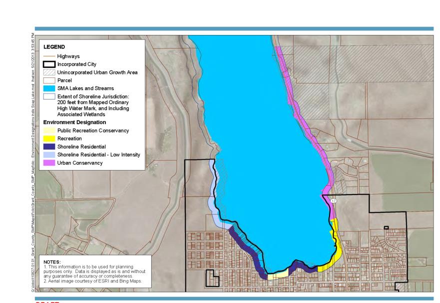
(Ord. 1194 § 2, 2014).
Nonconforming private moorage facilities are governed by regulations found in SLMC 14.08.720, Nonconforming structures.