


Chapter 17.35
WETLANDS
Sections:
17.35.010 Applicability and mapping.
17.35.015 Application and review procedure.
17.35.025 Delineation and wetland analysis requirements.
17.35.035 Establishing buffers.
17.35.050 Residential density and on-site density transfer.
17.35.055 Alternative review process, Corps of Engineers Section 404 individual permits.
17.35.005 Purpose.
The purpose of this chapter is to avoid, or, in appropriate circumstances, to minimize, rectify, reduce or compensate for impacts arising from land development and other activities affecting wetlands. Additionally, the purpose of this chapter is to maintain and enhance the biological and physical functions of wetlands with respect to water quality maintenance, storm water and floodwater storage and conveyance, fish and wildlife habitat, primary productivity, recreation, education, and historic and cultural preservation. When avoiding impacts is not reasonable, mitigation should be implemented to achieve no net loss of wetlands in terms of acreage, function and value.
(Ord. 343 § 1, 2002).
17.35.010 Applicability and mapping.
This chapter shall apply to all areas satisfying the criteria for wetland presence. The Department has created wetland maps for general informational purpose. The presence or absence of wetlands on a site shall be based on field conditions observed at the site.
(Ord. 343 § 1, 2002).
17.35.015 Application and review procedure.
A. When any regulated activity is proposed on a site that may be within 200 feet of a wetland, an application containing the following shall be submitted to the Department:
1. Site plan(s);
2. Wetland analysis report and/or delineation prepared by a qualified wetland specialist, if required;
3. Mitigation plan, if required;
4. Such other information as the Director determines is necessary to adequately evaluate the impact of the regulated activity on the wetland and buffer.
B. The procedure to obtain approval for a regulated activity on a site that contains wetlands and/or buffers shall be in accordance with UPMC Title 22, Administration of Development Regulations, which provides for consolidated and timely permit review.
C. Review and Approval. Approval of a regulated activity on a site that contains wetlands and/or wetland buffers shall be granted upon a determination that the wetland analysis report and mitigation plan meet all applicable requirements and that the mitigation plan, monitoring program and contingency plan, if required, are tied to an acceptable financial guarantee. Except as specifically exempted, regulated activities within wetlands and wetland buffers shall not be permitted unless the applicant demonstrates that mitigation sequencing is considered pursuant to the mitigation section of this chapter.
D. Expiration. Approvals shall be valid for a period of time equal to the time that any associated land use permit or approval is valid.
(Ord. 343 § 1, 2002).
17.35.020 Wetland categories.
Wetland categories shall be determined based upon the Washington State Wetland Rating System for Western Washington, current edition. Wetlands shall be generally categorized as follows:
A. Category I wetlands are:
1. Relatively undisturbed estuarine wetlands larger than one acre;
2. Wetlands of high conservation value that are identified by scientists of the Washington Natural Heritage Program/DNR;
3. Bogs;
4. Mature and old-growth forested wetlands larger than one acre;
5. Wetlands in coastal lagoons; and
6. Wetlands that perform many functions well (scoring 23 points or more).
These wetlands:
1. Represent unique or rare wetland types;
2. Are more sensitive to disturbance than most wetlands;
3. Are relatively undisturbed and contain ecological attributes that are impossible to replace within a human lifetime; or
4. Provide a high level of functions.
B. Category II wetlands are:
1. Estuarine wetlands smaller than one acre, or disturbed estuarine wetlands larger than one acre; or
2. Wetlands with a moderately high level of functions (scoring between 20 and 22 points).
C. Category III wetlands are:
1. Wetlands with a moderate level of functions (scoring between 16 and 19 points); or
2. Wetlands that often can be adequately replaced with a well-planned mitigation project.
Wetlands scoring between 16 and 19 points generally have been disturbed in some ways and are often less diverse or more isolated from other natural resources in the landscape than Category II wetlands.
D. Category IV wetlands have the lowest levels of functions (scoring less than 16 points) and are often heavily disturbed. These are wetlands that should be able to be replaced, or in some cases to be improved upon. However, experience has shown that replacement cannot be guaranteed in any specific case. These wetlands may provide some important functions, and should be protected to some degree.
(Ord. 670 § 1 (Exh. A), 2016; Ord. 630 § 1 (Exh. A), 2013; Ord. 343 § 1, 2002. Formerly 17.35.030).
17.35.025 Delineation and wetland analysis requirements.
Regulated activities shall comply with the following requirements:
A. The Department may require a delineation report prepared in accordance with the approved Federal wetland delineation manual and applicable regional supplements to determine if a regulated wetland is present on the site or to determine if the proposed activity is within 200 feet of a wetland. All areas within the City meeting the wetland designation criteria in this procedure are hereby designated critical areas and are subject to the provisions of this chapter. A wetland delineation report shall be prepared by a qualified wetland specialist. The delineation report shall indicate wetland and/or buffer boundaries that may extend onto the site. While the delineation report shall discuss all wetland areas within 200 feet of the site, only those boundaries within the site property lines need be marked in the field. A preliminary site inspection may be required by the Department to determine whether a delineation report is needed.
B. If, on the basis of a delineation report, the Department determines that a regulated wetland is on the site, or within 200 feet of the site so that a wetland buffer boundary may extend onto the site, then the Department shall require a wetland analysis report. A wetland analysis report must be prepared by a qualified wetland specialist. A wetland analysis report shall include the following:
1. Vicinity map;
2. When available, a copy of a National Wetland Inventory Map (U.S. Fish and Wildlife Service) and/or a City wetland inventory map identifying the wetlands on or adjacent to the site;
3. A site map setting forth all of the following:
a. Surveyed wetland boundaries based upon a delineation by a wetland specialist;
b. Site boundary property lines and roads;
c. Internal property lines, rights-of-way, easements, etc.;
d. Existing physical features of the site including buildings, fences, and other structures, roads, parking lots, utilities, water bodies, etc.;
e. Contours at the smallest readily available intervals, preferably at two-foot intervals;
f. Hydrologic mapping showing patterns of surface water movement and known subsurface water movement into, through, and out of the site area;
g. Location of all test holes and vegetation sample sites, numbered to correspond with flagging in the field and field data sheets;
h. The Department may require an air photo with overlays displaying the site boundaries and wetland delineation;
4. A report that includes the following:
a. Location information (legal description, parcel number and address);
b. Delineation report. The wetland boundaries on the site established by the delineation shall be staked and flagged in the field. If the wetland extends outside the site, the delineation report shall discuss all wetland areas within 200 feet of the site, but need only delineate those wetland boundaries within the site;
c. General site conditions including topography, acreage, and surface areas of all wetlands identified in the City wetland atlas and water bodies within one-quarter mile of the subject wetland(s);
d. Hydrological analysis, including topography, of existing surface and known significant subsurface flows into and out of the subject wetland(s);
e. Analysis of functional values of existing wetlands, including vegetative, faunal, and hydrologic conditions;
5. A summary of proposed activity and potential impacts to the wetland(s);
6. Recommended wetland category, including rationale for the recommendation;
7. Recommended buffer boundaries, including rationale for boundary locations;
8. Proposed on-site residential density transfer from wetlands and/or buffers to upland areas;
9. Site plan of proposed activity, including location of all parcels, tracts, easements, roads, structures, and other modifications to the existing site. The location of all wetlands and buffers shall be identified on the site plan.
C. The Department shall review and approve the wetland analysis report to determine the appropriate wetland category and buffer, and shall include the wetland in the City wetland maps and inventory if not already included. The Department shall approve the report’s findings and proposals unless specific, written reasons are provided which justify not doing so.
(Ord. 670 § 1 (Exh. A), 2016; Ord. 343 § 1, 2002).
17.35.030 Exemptions.
In addition to the activities and uses listed in UPMC 17.10.035, the following activities are exempt from the provisions of this chapter. Such activities are not exempt from the Shoreline Master Program requirements in UPMC Title 18 unless explicitly named as an exempt activity under WAC 173-27-040, in accordance with UPMC 18.15.030.
A. Subject to BMPs, construction or reconstruction of single-family, duplex or condominium units on a lot that was platted, or approved pursuant to a planned development district (PDD), prior to adoption of the ordinance codified in this chapter. Structures shall be located outside of buffers in effect when the lot was created and shall be subject to the wetland regulations in effect at that time. A completed building permit application for the construction or reconstruction must be submitted within five years of final plat or PDD approval, or this exemption does not apply.
B. Pursuant to BMPs, construction of a one-family dwelling and regulated activities accessory to a one-family dwelling on a lot of record that was legally created prior to the effective date of this regulation shall be allowed in the buffer if all of the following provisions are met:
1. Development outside the buffer is not feasible.
2. The applicant demonstrates to the department that adverse impacts to wetlands will be mitigated to the greatest extent possible.
3. The residence and accessory structures are located to minimize intrusion into the buffer to the greatest extent possible.
C. Activities in artificial wetlands, except those artificial wetlands intentionally created for replacement, enhancement or similar purposes.
D. Activities affecting isolated Category III and IV wetlands less than 1,000 square feet that:
1. Are not associated with riparian areas or buffers.
2. Are not part of a wetland mosaic.
3. Do not contain habitat identified as essential for local populations of priority species identified by the Washington Department of Fish and Wildlife or species of local importance identified by the City.
E. Placement of access roads, utility lines and utility poles across a Category IV wetland and/or a buffer for a Category IV wetland if there is no reasonable alternative and if construction activity is conducted in accordance with BMPs.
F. For legally established gardens and landscaped areas existing on the effective date of this regulation, activities to maintain their existing condition and appearance. Activities may include, but are not limited to, mowing lawns, weeding, harvesting and replanting of garden crops, pruning and planting of vegetation. Use of pesticides and chemical fertilizers is prohibited.
G. Activities designed for protection, maintenance and enhancement of wetlands, if approved by the Director.
H. Pursuant to BMPs, activities undertaken on the site of an existing holding pond, water quality facility or similar facility, intended to improve water quality, flow control or other primary function of the facility.
I. Public stormwater retention/detention facilities and stormwater conveyance facilities such as bioswales, open trenches and culverts not designed to drain wetlands may be constructed within Category II, III and IV wetland buffers; provided, that the following conditions are met:
1. No untreated stormwater is released from the facility into the wetland or buffer;
2. The applicant demonstrates that water levels within the wetland will be maintained at pre-existing levels;
3. Water levels are monitored annually to ensure that pre-existing functions of the wetland are not significantly lost through fluctuations in wetland hydrology;
4. Maintenance activity is limited to removal of invasive vegetation and/or removal of sediment accumulation at inflow structures in a manner acceptable to the Department;
5. All construction activity is conducted in accordance with accepted BMPs. This conditional exemption would not apply in situations where there are threatened or endangered species, or sensitive plants, unless approved by the State Department of Fish and Wildlife or Department of Natural Resources, respectively. All permits from other regulatory agencies must be obtained.
6. In shoreline jurisdiction, stormwater facilities shall not be located within the buffer of Category II wetlands unless there is no other feasible option. In Category III and IV wetland buffers within shoreline jurisdiction, these facilities shall be limited to the outer 25 percent of the buffer unless there is no other feasible option.
J. A utility line may be placed in an underground trench within a Category II, III or IV wetland or its buffer, although generally, boring is preferred to trenching unless infeasible for a specific proposal. Such activities are not exempt from the provisions of this chapter when located in an associated wetland as defined in UPMC 18.10.020. These activities should be discouraged where there is a high water table and be limited to the outer 25 percent of buffers unless there is no feasible alternative. Boring and trenching should not be permitted in Category II wetlands or their buffers unless there is no other option, due to the lengthy recovery time from disturbance in such wetlands. There must be no resulting changes in pre-construction contours, and trench excavation materials that are temporarily sidecast must be stabilized to prevent erosion and sedimentation. All sidecast materials shall be replaced within the trench or removed after 90 days, unless the Department grants an extension. The trench shall be the minimum size required to construct the utility line. The top 12 inches of the trench shall be backfilled with topsoil from the trench excavation. Trenches in wetlands shall be backfilled with wetland topsoil from the excavation. Trench excavation should be restricted to the dry season. All permits from other regulatory agencies must be obtained.
K. Subject to BMPs, placement of utility lines which do not require excavation or utility poles, in any part of a buffer for a Category III or IV wetland. They may be placed in a buffer for a Category I or II wetland, provided they are not located closer than one-half the buffer width from the edge of the wetland.
L. Public park improvements, including construction of public trails and associated viewing platforms, subject to BMPs, provided no net loss of wetlands occurs.
(Ord. 630 § 1 (Exh. A), 2013; Ord. 343 § 1, 2002. Formerly 17.35.020).
17.35.035 Establishing buffers.
A. Buffer widths shall be determined according to Table 3 and the provisions of this section.
The standard buffer widths in Table 3 have been established in accordance with the best available science. They are based on the category of wetland and the habitat score as determined by a qualified wetland professional using the Washington State wetland rating system for Western Washington.
1. The use of the standard buffer widths requires the implementation of the measures in Table 4, where applicable, to minimize the impacts of the adjacent land uses.
2. If an applicant chooses not to apply the mitigation measures in Table 4, then a 33 percent increase in the width of all buffers is required. For example, a 75-foot buffer with the mitigation measures would be a 100-foot buffer without them.
3. The standard buffer widths assume that the buffer is vegetated with a native plant community appropriate for the ecoregion. If the existing buffer is unvegetated, sparsely vegetated, or vegetated with invasive species that do not perform needed functions, the buffer should either be planted to create the appropriate plant community or the buffer should be widened to ensure that adequate functions of the buffer are provided.
4. Additional buffer widths are added to the standard buffer widths. For example, a Category I wetland scoring nine points for habitat function would require a buffer of 225 feet (75 plus 150).
|
|
Buffer Width (in feet) Based on Habitat Score |
|||
|---|---|---|---|---|
|
Wetland Category |
3 – 4 |
5 |
6 – 7 |
8 – 9 |
|
Category I: Based on Total Score |
75 |
105 |
165 |
225 |
|
Category I: Bogs and Wetlands of High Conservation Value |
190 |
225 |
||
|
Category I: Coastal Lagoons |
150 |
165 |
225 |
|
|
Category I: Forested |
75 |
105 |
165 |
225 |
|
Category I: Estuarine |
150 (buffer width not based on habitat scores) |
|||
|
Category II: Based on Score |
75 |
105 |
165 |
225 |
|
Category III (all) |
60 |
105 |
165 |
225 |
|
Category IV (all) |
40 |
|||
|
Disturbance |
Required Measures to Minimize Impacts |
|---|---|
|
Lights |
• Direct lights away from wetland |
|
Noise |
• Locate activity that generates noise away from wetland • If warranted, enhance existing buffer with native vegetation plantings adjacent to noise source • For activities that generate relatively continuous, potentially disruptive noise, such as certain heavy industry or mining, establish an additional 10 ft heavily vegetated buffer strip immediately adjacent to the outer wetland buffer |
|
Toxic runoff |
• Route all new, untreated runoff away from wetland while ensuring wetland is not dewatered • Establish covenants limiting use of pesticides within 150 ft of wetland • Apply integrated pest management |
|
Stormwater runoff |
• Retrofit stormwater detention and treatment for roads and existing adjacent development • Prevent channelized flow from lawns that directly enters the buffer • Use low intensity development techniques (per the Low Impact Development Technical Guidance Manual for Puget Sound, prepared by the Washington State University Extension and Puget Sound Partnership) |
|
Change in water regime |
• Infiltrate or treat, detain, and disperse into buffer new runoff from impervious surfaces and new lawns |
|
Pets and human disturbance |
• Use privacy fencing OR plant dense vegetation to delineate buffer edge and to discourage disturbance using vegetation appropriate for the ecoregion • Place wetland and its buffer in a separate tract or protect with a conservation easement |
|
Dust |
• Use best management practices to control dust |
|
Disruption of corridors or connections |
• Maintain connections to off-site areas that are undisturbed • Restore corridors or connections to off-site habitats by replanting |
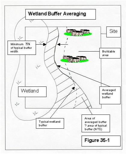
B. Buffer averaging to improve wetland protection may be permitted when all of the following conditions are met:
1. The wetland has significant differences in characteristics that affect its habitat functions, such as a wetland with a forested component adjacent to a degraded emergent component or a “dual-rated” wetland with a Category I area adjacent to a lower-rated area.
2. The buffer is increased adjacent to the higher-functioning area of habitat or more-sensitive portion of the wetland and decreased adjacent to the lower-functioning or less-sensitive portion as demonstrated by a critical areas report from a qualified wetland professional.
3. The total area of the buffer after averaging is equal to the area required without averaging.
4. The buffer at its narrowest point is never less than either 75 percent of the required width or 75 feet for Category I and II, 50 feet for Category III, and 25 feet for Category IV, whichever is greater. See Figure 35-1.
C. Buffer averaging to allow reasonable use of a parcel may be permitted when all of the following are met:
1. There are no feasible alternatives to the site design that could be accomplished without buffer averaging.
2. The averaged buffer will not result in degradation of the wetland’s functions and values as demonstrated by a critical areas report from a qualified wetland professional.
3. The total buffer area after averaging is equal to the area required without averaging.
4. The buffer at its narrowest point is never less than either 75 percent of the required width or 75 feet for Category I and II, 50 feet for Category III and 25 feet for Category IV, whichever is greater. See Figure 35-1.
D. The Department may require increased buffer width on a case-by-case basis when a larger buffer is necessary to protect wetland functions and values. This determination shall be supported by appropriate documentation showing that it is reasonably related to protection of the functions and values of the regulated wetland. Such determination shall demonstrate that:
1. The wetland is used by a plant or animal species listed by the Federal government or the State as endangered, threatened, candidate, sensitive, monitored or documentary priority species or habitats, or essential or outstanding habitat for those species or has unusual nesting or resting sites such as heron rookeries or raptor nesting trees; or
2. The adjacent land is susceptible to severe erosion, and erosion control measures will not effectively prevent adverse wetland impacts; or
3. The adjacent land has minimal vegetative cover or slopes greater than 30 percent.
E. To facilitate long-range planning using a landscape approach, the Department may identify and preassess wetlands using the rating system and establish appropriate wetland buffer widths for such wetlands. The Department will prepare maps of wetlands that have been preassessed in this manner.
F. Measurement of Wetland Buffers. All buffers shall be measured perpendicular from the wetland boundary as surveyed in the field. The buffer for a wetland created, restored, or enhanced as compensation for approved wetland alterations shall be the same as the buffer required for the category of the created, restored, or enhanced wetland. Only fully vegetated buffers will be considered. Lawns, walkways, driveways, and other mowed or paved areas will not be considered buffers or included in buffer area calculations.
G. Buffers on Mitigation Sites. All mitigation sites shall have buffers consistent with the buffer requirements of this chapter. Buffers shall be based on the expected or target category of the proposed wetland mitigation site.
H. Buffer Maintenance. Except as otherwise specified or allowed in accordance with this chapter, wetland buffers shall be retained in an undisturbed or enhanced condition. In the case of compensatory mitigation sites, removal of invasive nonnative weeds is required for the duration of the financial guarantee required in UPMC 17.35.045.
I. Overlapping Critical Area Buffers. If buffers for two contiguous critical areas overlap (such as buffers for a stream and a wetland), the wider buffer applies.
(Ord. 670 § 1 (Exh. A), 2016; Ord. 630 § 1 (Exh. A), 2013; Ord. 343 § 1, 2002).
17.35.040 Buffer provisions.
A. When buffer boundaries have been determined they shall be marked in the field by a licensed surveyor. The markers shall be clearly visible, durable, and permanently affixed to the ground.
B. Prior to final project approval, the part of the wetland and/or buffer that is on the site shall be placed in a separate wetland tract or tracts, protective easement, public or private land trust dedication, or similarly preserved through an appropriate permanent protective mechanism as determined by the City. All wetland tracts, protective easements, land trust dedications and other similarly preserved areas shall remain undeveloped in perpetuity, except as they may be altered pursuant to this chapter.
C. Prior to final project approval of any wetland application, the common boundary between a wetland tract, protective easement, land trust dedication, or other similarly preserved area and the adjacent land shall be identified with permanent signs and/or fencing. Sign and fencing locations, wording, and size and design specifications shall be as required by the Department.
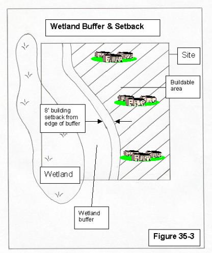
D. A building setback line of eight feet shall be required from the outside edge of the buffer (See Figure 35-3). The eight-foot building setback shall be required regardless of the width of the buffer. The eight-foot building setback shall be considered a minimum setback and shall not be construed to reduce or eliminate additional setbacks as required by another regulation, code, or State or Federal law.
E. At any time after a wetland tract, protective easement, land trust dedication, or other similarly preserved area has been established, the owner may submit a delineation report to the Department. If the owner can demonstrate that a natural boundary change has occurred, or that a wetland no longer exists, the wetland tract, protective easement, land trust dedication, or other similarly preserved area may be altered or eliminated, as appropriate. If a wetland boundary has changed or a wetland has been eliminated due wholly or in part to illegal activity, a change or elimination of wetland tract, protective easement, land trust dedication, or other similarly preserved area shall not be permitted.
F. A wetland tract, protective easement, land trust dedication, or other similarly preserved area is not required for utility lines in easements on lands not owned by the jurisdiction conducting the regulated activity.
G. Except as otherwise specified, buffers shall be retained in a natural condition.
H. The wetland buffer shall not extend away from the wetland beyond an existing substantial linear improvement such as an improved road, dike, or levee, where an applicant can show that such existing improvement significantly reduces the impact the proposed activities would have on the wetland.
I. The Department may require protection measures or erosion control measures such as temporary or permanent fencing to provide for protection of a wetland and buffer when any regulated activities are proposed on a site, but are not proposed within a wetland and/or buffer.
(Ord. 343 § 1, 2002).
17.35.045 Mitigation.
Regulated activities within wetlands and buffers shall be mitigated pursuant to this chapter. Where SEPA environmental review is required, a threshold determination may not be made prior to Department review of the mitigation plan.
A. All activities in wetlands and/or buffers shall be mitigated according to this section and the Department of Ecology manual: Wetland Mitigation in Washington State, Part 1: Agency Policies and Guidance (Version 1, Publication No. 06-06-011a, March 2006) and Wetland Mitigation in Washington State, Part 2: Developing Mitigation Plans (Version 1, Publication No. 06-06-011b, March 2006). Except as specifically exempted, regulated activities shall not be permitted within wetlands and/or buffers unless an applicant demonstrates that all reasonable attempts have been made to avoid impacts to the wetland and/or buffer. Mitigation is considered in order of preference as noted below with (1) being most preferable and (5) being the least preferable. Applicants must establish that mitigation has been considered in order of preference prior to permit issuance. There may be circumstances when an alternative mitigation strategy is preferable.
1. Avoiding the impact altogether by not taking a certain action or parts of actions within the wetland and/or buffer;
2. Minimizing impacts by limiting the degree or magnitude of the action and its implementation, by using appropriate technology, or by taking affirmative steps to avoid or reduce impacts;
3. Rectifying the impact by repairing, rehabilitating, or restoring the affected environment;
4. Reducing or eliminating the impact over time by preservation and maintenance operations during the life of the action;
5. Compensating for the impact by replacing, enhancing or providing substitute resources or environments;
6. Monitoring the required compensation and taking remedial or corrective measures when necessary.
Mitigation for individual actions may include a combination of the above measures. Monitoring may be a part of one or more of the above measures.
B. Regulated activities which occur in buffers, and which will not eliminate wetland habitat, shall be mitigated according to a mitigation plan approved by the Department. A mitigation plan for regulated activities in buffers shall contain the following components:
1. General goals of the mitigation plan;
2. Approximated site topography before and after alteration;
3. Location of proposed mitigation area;
4. General hydrologic patterns on the site before and after construction;
5. General plant selection and justification, planting instructions, and approximate planting sequencing and schedule;
6. A maintenance plan;
7. A monitoring and contingency plan;
8. A financial guarantee to ensure maintenance and/or implementation of the contingency plan. The financial guarantee must be equal to or greater than 20 percent of the estimated cost of the mitigation work, but in no case shall be less than is necessary to implement the contingency plan.
C. Compensatory mitigation shall be required for filling wetlands and for other regulated activities in wetlands. Compensatory mitigation shall be accomplished per the Department of Ecology manual: Guidelines for Developing Freshwater Wetlands Mitigation Plans and Proposals, current edition. The above-referenced document was developed jointly by six agencies including the Washington State Department of Ecology and Department of Fish and Wildlife, U.S. Army Corps of Engineers, U.S. Environmental Protection Agency and the U.S. Fish and Wildlife Service. These agencies, together with the City, have regulatory authority over wetland filling and related mitigation. Consistency with the above-referenced document will ensure that submitted plans are adequately detailed for review by all responsible agencies. Replacement ratios for compensatory mitigation shall be pursuant to the subsection below.
1. When regulated activities occur in wetlands, the applicant shall preserve, restore, create, or enhance equivalent areas of wetlands. Equivalent areas shall be determined according to acreage, functional value, type, location, time factors, and projected success. No overall net losses shall occur in wetland acreage, functions and/or values, and any restored, created, or enhanced wetland shall be as persistent as the wetland it replaces. Buffers pursuant to UPMC 17.35.035 shall be provided for created, restored or enhanced wetlands.
2. When an applicant proposes to alter or eliminate wetland, the applicant shall replace, restore and/or enhance acreage at the following ratios:
|
Category and Type of Wetland |
Creation or Re-establishment |
Rehabilitation |
Enhancement |
Preservation |
|---|---|---|---|---|
|
Category I: Bog, Natural Heritage site |
Not considered possible |
6:1 |
Case by case |
10:1 |
|
Category I: Mature Forested |
6:1 |
12:1 |
24:1 |
24:1 |
|
Category I: Based on functions |
4:1 |
8:1 |
16:1 |
20:1 |
|
Category II |
3:1 |
6:1 |
12:1 |
20:1 |
|
Category III |
2:1 |
4:1 |
8:1 |
15:1 |
|
Category IV |
1.5:1 |
3:1 |
6:1 |
10:1 |
*Ratios read as follows: Acreage replaced: Acreage lost
3. Ratios provided are for proposed projects with in-kind replacement that occurs prior to regulated activities on the site. Replaced, restored or enhanced wetlands must be located within the same drainage basin as the filled wetland, but are not required to be located on the same property. The Department may increase the ratios under the following circumstances:
a. Uncertainty as to the probable success of the proposed restoration, enhancement or creation; or
b. Significant period of time between destruction and replication of wetland functions; or
c. Projected losses in wetland functional value; or
d. Out-of-kind compensation.
4. The Department may allow the minimum acreage replacement ratio to be decreased if the applicant provides findings of special studies coordinated with agencies with expertise, which demonstrate that no net loss of wetland function or value results from the decreased ratio. In no case shall the Department approve a ratio less than 1:1.
5. In-kind compensation shall be provided except where the applicant demonstrates that:
a. Greater functional and habitat values can be achieved through out-of-kind mitigation; or
b. The wetland system is already significantly degraded; or
c. Problems such as the presence of exotic vegetation and changes in watershed hydrology make implementation of in-kind compensation infeasible; or
d. Out-of-kind replacement will best meet identified regional goals (e.g., replacement of historically diminished wetland types).
D. Credit/Debit Method. To more fully protect functions and values, and as an alternative to the mitigation ratios found in the joint guidance “Wetland Mitigation in Washington State Parts I and II” (Ecology Publication No. 06-06-011a-b, Olympia, WA, March, 2006), the Department may allow mitigation based on the “credit/debit” method developed by the Department of Ecology in “Calculating Credits and Debits for Compensatory Mitigation in Wetlands of Western Washington: Operational Draft,” (Ecology Publication No. 10-06-011, Olympia, WA, February 2011, or as revised).
E. Financial Guarantees. Mitigation shall be accomplished prior to the start of any regulated activity that impacts wetland area.
1. If development permits are issued prior to completion of mitigation work, financial guarantees shall be required to ensure mitigation is completed. Financial guarantees shall be 125 percent of the estimated cost of implementation of the mitigation plan.
2. Appropriate financial guarantees shall be in place to ensure that maintenance, monitoring and/or contingency plans shall be accomplished. Financial guarantees for contingency plans should be 20 percent of the cost of implementation of the mitigation plan.
F. Wetland mitigation banking may be permitted as a flexible alternative to standard compensatory mitigation. Wetland mitigation banking shall be conducted per the requirements of Chapter 173-700 WAC.
1. Credits from a wetland mitigation bank may be approved for use as compensation for unavoidable impacts to wetlands when:
a. The bank is certified under State rules;
b. The Department determines that the wetland mitigation bank provides appropriate compensation for the authorized impacts; and
c. The proposed use of credits is consistent with the terms and conditions of the bank’s certification.
2. Replacement ratios for projects using bank credits shall be consistent with replacement ratios specified in the bank’s certification.
3. Credits from a certified wetland mitigation bank may be used to compensate for impacts located within the service area specified in the bank’s certification. In some cases, the service area of the bank may include portions of more than one adjacent drainage basin for specific wetland functions.
G. In-Lieu Fee. To aid in the implementation of off-site mitigation, the City may develop a program which prioritizes wetland areas for use as mitigation and/or allows payment in lieu of providing mitigation on a development site. This program shall be developed and approved through a public process and be consistent with State and Federal rules. The program should address:
1. The identification of sites within the City that are suitable for use as off-site mitigation. Site suitability shall take into account wetland functions, potential for wetland degradation, and potential for urban growth and service expansion; and
2. The use of fees for mitigation on available sites that have been identified as suitable and prioritized.
H. Advance Mitigation. Mitigation for projects with pre-identified impacts to wetlands may be constructed in advance of the impacts if the mitigation is implemented according to State and Federal rules.
I. Alternative Mitigation Plans. The Department may approve alternative critical areas mitigation plans that are based on best available science, such as priority restoration plans that achieve restoration goals identified in the SMP. Alternative mitigation proposals must provide an equivalent or better level of protection of critical area functions and values than would be provided by the strict application of this chapter.
The Department shall consider the following for approval of an alternative mitigation proposal:
1. The proposal uses a watershed approach consistent with Selecting Wetland Mitigation Sites Using a Watershed Approach (Ecology Publication No. 09-06-32, Olympia, WA, December 2009);
2. Creation or enhancement of a larger system of natural areas and open space is preferable to the preservation of many individual habitat areas;
3. Mitigation according to subsection (E) of this section is not feasible due to site constraints such as parcel size, stream type, wetland category, or geologic hazards;
4. There is clear potential for success of the proposed mitigation at the proposed mitigation site;
5. The plan shall contain clear and measurable standards for achieving compliance with the specific provisions of the plan. A monitoring plan shall, at a minimum, meet the provisions in subsection (J) of this section;
6. The plan shall be reviewed and approved as part of overall approval of the proposed use, Wetlands Guidance for Small Cities Western Washington Version Page A-23;
7. A wetland of a different type is justified based on regional needs or functions and values; the replacement ratios may not be reduced or eliminated unless the reduction results in a preferred environmental alternative;
8. Mitigation guarantees shall meet the minimum requirements as outlined in subsection (B)(8) of this section;
9. Qualified professionals in each of the critical areas addressed shall prepare the plan;
10. The City may consult with agencies with expertise and jurisdiction over the resources during the review to assist with analysis and identification of appropriate performance measures that adequately safeguard critical areas.
J. Monitoring Program and Contingency Plan.
1. If the wetland mitigation plan includes compensatory mitigation, a monitoring program shall be implemented to determine the success of the compensatory mitigation project.
2. Specific criteria shall be provided for evaluating the mitigation proposal relative to the goals and objectives of the project and for beginning remedial action or contingency measures. Such criteria may include water quality standards, survival rates of planted vegetation, species abundance and diversity targets, habitat diversity indices, or other ecological, geological or hydrological criteria.
3. A contingency plan shall be established for compensation in the event that the mitigation project is inadequate or fails.
4. Requirements of the monitoring program and contingency plan are as follows:
a. During monitoring, use scientific procedures for establishing the success or failure of the project;
b. For vegetation determinations, permanent sampling points shall be established;
c. Vegetative success equals 80 percent per year survival of planted trees and shrubs and 80 percent per year cover of desirable understory or emergent species;
d. Submit monitoring reports of the current status of the mitigation project to the Department. The reports are to be prepared by a qualified wetland specialist and shall include monitoring information on wildlife, vegetation, water quality, water flow, stormwater storage and conveyance, and existing or potential degradation, and shall be produced on the following schedule:
(1) At time of construction;
(2) Thirty days after planting;
(3) Early in the growing season of the first year;
(4) End of the growing season of first year;
(5) Twice the second year;
(6) Annually;
e. Monitor a minimum of three and up to 10 growing seasons, depending on the complexity of the wetland system. The time period will be determined and specified in writing prior to the implementation of the site plan;
f. If necessary, correct for failures in the mitigation project;
g. Replace dead or undesirable vegetation with appropriate plantings;
h. Repair damages caused by erosion, settling, or other geomorphological processes;
i. Redesign mitigation project (if necessary) and implement the new design;
j. Correction procedures shall be approved by a qualified wetland specialist and the City’s environmental official.
(Ord. 670 § 1 (Exh. A), 2016; Ord. 630 § 1 (Exh. A), 2013; Ord. 343 § 1, 2002).
17.35.050 Residential density and on-site density transfer.
The purpose of on-site density transfer is to cluster development in a manner that provides protection for wetlands and allows transfer of residential density from a wetland and/or wetland buffer area to an area on the same site that is neither wetland nor buffer. Those portions of the wetland and/or wetland buffer in which regulated activities are proposed to occur shall not be considered in calculating density transfer. Density transfer shall be determined as follows:
A. For sites containing regulated wetland buffer areas, full density credit may be transferred from the buffer area to the non-buffer area.
B. For sites containing regulated wetland areas, density transfer shall be calculated from the following table:
|
Percentage of site in wetland |
Amount of credit |
|
0–25% |
75% |
|
26–50% |
50% |
|
50–100% |
25% |
C. If an on-site density transfer would result in the creation of one or more lots smaller than the minimum lot size specified for lots within a conventional plat, the subdivision shall be designed and processed in accordance with the Design Standards and Guidelines for Small Lot and Multifamily Development adopted by reference in Chapter 19.53 UPMC.
(Ord. 566 § 1, 2010; Ord. 343 § 1, 2002).
17.35.055 Alternative review process, Corps of Engineers Section 404 individual permits.
When an Army Corps of Engineers Section 404 permit is required for a project involving wetlands, the Army Corps permitting process may be substituted for the City permitting process, except when the project is located within an associated wetland as defined in UPMC 18.10.020. If a proposal reviewed and conditioned by the Corps satisfies the intent of this chapter, no further wetland review shall be required by the City. All permits and approvals required by other City development regulations shall be required.
(Ord. 630 § 1 (Exh. A), 2013; Ord. 343 § 1, 2002).