


Chapter 21.51
CRITICAL AREAS REGULATIONS
Sections:
21.51.030 Applicability and critical area maps.
21.51.040 Critical area permitted uses – All.
21.51.050 General requirements applicable to critical areas.
21.51.060 Critical areas report.
21.51.070 Critical area mitigation requirements.
21.51.080 Critical aquifer recharge area.
21.51.090 Frequently flooded areas.
21.51.110 Geologically hazardous areas.
21.51.120 Fish and wildlife habitat conservation areas.
21.51.010 Purpose.
The purpose of this chapter is to designate critical areas and to establish standards for the protection of their functions and values in compliance with the Washington State Growth Management Act (Chapter 36.70A RCW) and the goals and policies of the Woodinville Comprehensive Plan. Included but not limited in this purpose statement are the following:
(1) Achieve no net loss of core preservation areas within fish and wildlife habitat conservation areas, which includes riparian corridors, and minimize impacts to and retain quality habitat areas, and protect species of concern, priority species, and species of local importance;
(2) Avoid wetland impacts and achieve a goal of no net loss of wetland function, value, and acreage; and where possible enhance and restore wetlands;
(3) Achieve no net loss of structure, value, and functions of natural systems within frequently flooded areas;
(4) Protect critical aquifer recharge areas by avoiding land use activities that pose potential contamination, and minimize impacts to recharge areas through the application of performance standards;
(5) Avoid and minimize potential impacts to life and property from geologic hazards such that sites are rendered as safe as those not containing such hazard through the application of the appropriate levels of study and analysis and sound engineering principles; and
(6) Protect critical areas in accordance with the Growth Management Act and through the application of best available science, as determined according to WAC 365-195-900 through 365-195-925, and in consultation with State and Federal agencies and other qualified professionals. (Ord. 784 § 14 (Att. A), 2025)
21.51.020 General provisions.
(1) This chapter shall not repeal, abrogate, or impair any existing regulations. However, where this chapter imposes more protective requirements for the environment, the requirements of this chapter shall prevail.
(2) Compliance with this chapter does not constitute compliance with other Federal, State, and local regulations and permit requirements (e.g., shoreline permits, HPA permits, Army Corps of Engineers Section 404 permits and 401 certifications, Ecology Administrative Orders, or NPDES permits). The applicant is responsible for complying with other requirements apart from the requirements established in this chapter.
(3) If the buffers for two or more contiguous critical areas overlap (such as a riparian management zone for a stream and a wetland buffer), the overlapping buffer area that extends the furthest out at any given point shall apply.
(4) If application of this chapter would deny all reasonable use of the subject property, the owner may apply for a reasonable use permit pursuant to WMC 21.84.030. Variances to the strict requirements of this chapter shall not be granted, except as prescribed in subsection (5) of this section.
(5) If application of this chapter would prohibit a development proposal by a public agency or public utility, the public agency or public utility may apply for a public entity critical area exception pursuant to WMC 21.84.030. (Ord. 784 § 14 (Att. A), 2025)
21.51.030 Applicability and critical area maps.
(1) Compliance. The provisions of this chapter apply to all land uses and activities within the City limits, except where the shoreline critical areas regulations apply pursuant to WMC 21.77.030. No permit or authorization shall be approved or issued to alter the conditions of any land, water, or vegetation, or to construct or alter any structure or improvements without first complying with the requirements of this chapter.
(2) Alterations. Any human activity that results or is likely to result in an impact upon the existing condition of a critical area or its buffer is an alteration subject to this chapter. Alternations include, but are not limited to, grading, filling, channelizing, dredging, clearing to include clearing vegetation, construction, compaction, excavation, or any other activity that changes the character of the critical area. Alterations that are excluded from this chapter include walking, fishing, other passive recreational activities, and other similar activities whose impacts are de minimis.
(3) Critical Area Maps. The City’s critical area map is for reference only and serves as a guide to identify possible critical areas on a site. Site-specific investigation and analysis are required to determine the actual presence or absence of the features that define critical areas. The Department will maintain the latest critical areas maps and may update them as new information becomes available. The critical area maps shall include, but are not limited to the current adopted versions of the following:
(a) Federal Emergency Management Administration flood insurance rate maps;
(b) U.S. Geological Survey landslide hazard, seismic hazard, and volcano hazard maps;
(c) Washington Department of Natural Resources seismic hazard maps for Western Washington;
(d) Washington Department of Natural Resources slope stability map;
(e) National Wetlands Inventory;
(f) Washington Department of Fish and Wildlife Priority Habitat and Species maps;
(g) Other critical area maps adopted by the City of Woodinville, including the Critical Aquifers Recharge Areas map and Geologically Sensitive Areas map. (Ord. 784 § 14 (Att. A), 2025)
21.51.040 Critical area permitted uses – All.
Critical Area Allowances. The following development, activities and associated uses may be allowed in critical areas and their buffers without the need for a critical area review process:
(1) Emergency actions necessary to prevent an immediate threat to public health, safety, and welfare or that pose an imminent risk of damage to public or private property and that require remedial or preventive action in a time frame too short to allow for compliance with the requirements of this chapter. Emergency actions are required to use reasonable methods to address the emergency with the least possible impact on the critical area. Alterations undertaken pursuant to this subsection shall be reported to the City immediately. The impacted critical areas and their buffers shall be fully restored in accordance with a critical areas report and mitigation plan.
(2) Minor site investigative work necessary for land use submittals, such as surveys, soil logs, percolation tests, and other related activities, where:
(a) Such activities do not require construction of new roads or significant amounts of excavation; and
(b) The disruption to the critical area shall be minimized and the disturbed areas immediately restored.
(3) Passive recreation, educational and scientific research that does not degrade critical areas or critical area buffers and that does not involve clearing or other types of construction activity.
(4) Construction or modification of navigational aids and boundary markers.
(5) Maintenance, operation, repair or replacement of publicly improved roadways or recreation areas; provided, that any such alteration does not: (a) involve the expansion of structures or related improvements into previously unimproved areas horizontally and in depth, and (b) result in an alteration of a critical area.
(6) Normal maintenance, remodels or repairs of existing structures and facilities, or legal preexisting and ongoing uses/operations of a site, provided there is no further intrusion into a critical area or its buffers, including no increases to the size of previously approved building footprints within the critical area or its buffer, and there is no significant increase in risk to life or property as result of the action.
(7) Replacement, modification, installation or construction of streets and utilities in existing developed utility easements, improved street rights-of-way, or developed private streets if the activity does not further permanently alter or increase the impact to or encroach further within a critical area or buffer and must utilize best management practices. Utilities under this provision include water and sewer lines, stormwater facilities, and franchise (private) owned utilities such as natural gas lines, telecommunication lines, cable communication lines, electrical lines and appurtenances associated with these utilities.
(8) Public and private trails designed for nonmotorized traffic only if:
(a) There is no practicable alternative that would allow placement of the trail outside of critical area or critical area buffer;
(b) The trail surface shall meet all other requirements including water quality standards;
(c) Trails proposed in stream or wetland buffers shall be in the outer 25 percent of the buffer area, except where bridges or access points are proposed;
(d) Stream and wetland buffer widths shall be increased, where possible, equal to the width of the trail corridor, including disturbed areas;
(e) Trail corridors in critical areas and buffers shall not exceed eight feet in width; and
(f) Trails proposed to be in landslide or erosion hazard areas shall be constructed in a manner that does not increase the risk of landslide or erosion and in accordance with an approved geotechnical report.
(9) The select removal of vegetation as follows:
(a) The removal of invasive weeds, including, but not limited to, Himalayan blackberry, evergreen blackberry, ivy, holly, laurel, Japanese knotweed, and other species on the King County Noxious Weed List, provided the appropriate erosion-control measures are used, and the area is replanted with native vegetation;
(b) The cutting and removal of trees from critical areas and buffers that are hazardous and pose a threat to public safety, or pose an imminent risk of damage to private property provided the provisions in this chapter are followed;
(c) Measures to control a fire or halt the spread of disease or damaging insects consistent with the State Forest Practices Act, Chapter 76.09 RCW, if the removed vegetation is replaced in-kind or with similar native species within one year in accordance with an approved restoration plan prepared by a qualified professional.
(10) Conservation, preservation, restoration and/or enhancement that includes the following:
(a) Conservation and/or preservation of soil, water, vegetation, fish and/or other wildlife that does not entail alteration of the location, size, dimensions, or functions of an existing critical area and/or buffer; and/or
(b) Restoration and/or enhancement of critical areas or buffers if the actions: (i) provide a net ecological gain to the existing ecosystem functions and values of the critical area or buffer; (ii) avoid disturbance to existing native vegetation and wildlife habitat, unless such disturbances is necessary to restore the area; (iii) may increase the dimensions or size of a buffer if the adjustments result in improved ecological functions; and (iv) are implemented according to a restoration and/or enhancement plan that has been approved by the appropriate City staff.
(11) Activities involving artificially created wetlands or streams intentionally created from non-wetland sites, including but not limited to grass-lined swales, irrigation and drainage ditches, detention facilities, and landscape features, except wetlands, streams, or swales created as mitigation or that provide habitat for native fishes.
(12) Minor activities not listed above and determined by the Director to have a de minimis impact on a critical area. (Ord. 784 § 14 (Att. A), 2025)
21.51.050 General requirements applicable to critical areas.
The requirements set forth in this section apply to all critical areas and critical area buffers regulated by this chapter.
(1) Avoid Impacts.
(a) A proposal for development, use or activity must avoid all impacts that result in a net loss of critical area ecosystem functions and values. In the case of geologically hazardous areas, the development, use or activity must avoid all impacts resulting in an unacceptable level of risk.
(b) Unless allowed differently by other provisions of this chapter:
(i) If alteration to a fish and wildlife habitat conservation area, wetland and/or associated buffers are proposed, all impacts to the critical areas caused by the development, use or activity proposal must be mitigated in accordance with mitigation sequencing prescribed as follows:
(A) Avoiding the impact altogether by not taking certain actions or parts of actions;
(B) Minimizing impacts by limiting the degree or magnitude of the action and its implementation by using appropriate technology, or by taking affirmative steps to avoid or reduce impacts;
(C) Rectifying the impact by repairing, rehabilitating, or restoring the affected environment;
(D) Reducing or eliminating the impact over time by preservation and maintenance operations during the life of the action;
(E) Compensating for the impact by replacing or providing substitute resources or environments; and/or
(F) Monitoring the impacts and taking appropriate corrective measures; or
(ii) If any impacts to critical areas or their buffers are proposed, the following are examples of some actions that might be considered to satisfy avoiding the impact before considering other mitigation sequencing options:
(A) Alternative building locations on the property;
(B) Adjustments to project footprints and orientation;
(C) Modification of building and structure setbacks, if authorized; and/or
(D) Alternative building design.
(iii) If alteration to a geologically hazardous area is proposed, the development, use or activity must comply with a City-approved geotechnical report that assesses the risk to health and safety, and includes recommendations for reducing all risks to an acceptable level through engineering, design, and/or construction practices.
(2) Critical Area Review.
(a) A critical area determination and/or critical area alteration is required for all activities involving alteration on property where indicators of a critical area or a critical area buffer exist. The review procedures are set forth in WMC 21.82.030. If indicators of a critical area or critical area buffer are present on or near a property, the Director may require a qualified professional to evaluate the property and provide a written report to the City on the presence of critical areas or critical area buffers on or near the property.
(b) The Director may condition a proposed alteration as necessary to mitigate impacts to critical areas and/or critical area buffers and to conform to the standards set forth by this chapter.
(c) The Director may require critical area reports under this chapter to be evaluated by an independent qualified professional selected by the City at the applicant’s expense when the Director determines the independent evaluation to be necessary for reviewing a proposal.
(3) Building and Structure Setbacks. A minimum 10-foot setback from the edge of riparian management zones and wetlands including associated buffers is required to provide adequate distance and prevent encroachments into buffer areas to allow for maintenance and repair activity on buildings and structures. Trails, sidewalks, or stormwater facilities may be in the setback provided access for maintenance will not negatively impact the critical area. The Director may approve reductions to this 10-foot setback provided it can be demonstrated adequate measures are in place to prevent encroachment into a riparian area or a wetland or associated buffers.
(4) Notice on Title. To inform subsequent purchasers of real property about the presence of critical areas, the owner of the property containing a critical area or critical area buffer, and on which development is proposed, may be required to file for record with King County Auditor a notice indicating the presence of critical areas and/or critical area buffers. The notice must:
(a) Be in a form approved for recording by both the City and King County Auditor;
(b) State the presence of the critical area and/or critical area buffer on the property;
(c) Run with the land; and
(d) Include a statement to the effect that failure to provide such notice of the presence of critical areas to any purchaser prior to transferring any interest in the property is a violation of the Woodinville Municipal Code.
The City may require the property owner to provide proof that the notice has been filed and recorded within a time frame to be determined by the Director.
(5) Native growth protection areas (NGPA) are required for the following:
(a) A delineated NGPA in accordance with subsections (5)(b) through (5)(f) of this section is required for those development proposals on a property comprised of the following:
(i) New construction and/or reconstruction involving substantial improvement as defined in WMC 21.11A.200; or
(ii) Land divisions set forth in Chapter 21.91 WMC, excluding boundary line adjustments;
(b) A delineated NGPA in the form of a tract is required for the following:
(i) All landslide hazard areas and associated buffers greater than one acre in size, excluding landslide hazard and associated buffer areas approved for development per a geotechnical report accepted by the City;
(ii) All wetlands and wetland buffers;
(iii) All fish and wildlife habitat conservation areas, excluding ponds and lakes greater than one acre in size, and Type S streams; and
(iv) All other lands to be protected from impacts as conditioned by a project approval;
(c) The NGPA tract shall be recorded on all documents of title of record for all affected lots;
(d) An NGPA tract shall be held in an undivided interest by each owner of a lot within the development and this ownership interest shall pass with the ownership of the lot or shall be held by an incorporated homeowners’ association or other legal entity, which assures the ownership, maintenance, and protection of the NGPA tract;
(e) The NGPA tract shall be designated on the face of plat, short plat, binding site plan or other recorded drawing in a format approved by the City and include restrictions consistent with the following:
(i) The NGPA is designated as a protected habitat for fish and wildlife and as such shall be left in its natural state, except as enhancement to improve critical area functions and values that might be provided; and
(ii) Native vegetation shall be preserved in perpetuity within the NGPA to prevent harm to property and the environment;
(iii) The City has the right to enforce NGPA restrictions; and
(iv) The Director may modify these restrictions where it is found that such modifications are reasonable and will better implement the provisions of this chapter; and
(f) The Director may require a restrictive easement to delineate an NGPA, and may authorize an easement in lieu of NGPA tract, provided the conditions set forth in subsection (5)(e) of this section are included in the NGPA and protect the critical area in perpetuity.
(6) Divisions of Lands and Boundary Line Adjustments Containing a Critical Area.
(a) The division of land or alteration of a boundary line involving property containing a critical area, excluding aquifer recharge areas, must comply with the following:
(i) Land located wholly within a critical area, or its buffer may not be divided, excluding geologically hazardous and associated buffer areas approved for development per a geotechnical report accepted by the City;
(ii) Land located partially within a critical area, or its buffer may be divided; provided the developable portion of each new lot and its access is located outside of the areas excluded from development of a critical area or its buffer; and
(iii) Any alteration of property lines must be consistent with subsections (6)(a)(i) and (6)(a)(ii) of this section.
(b) Lot Area Credits. For divisions of land in the R-1 through R-8 zones and involve the placement of the critical area and critical area buffer in a tract as prescribed in subsection (5) of this section, the minimum dimensions of each individual lot for residentially zoned properties may follow the dimensional standards in Table 21.51.050(6).
|
Zone |
Minimum Lot Area |
Maximum Building Coverage |
Minimum Landscape Coverage |
Minimum Street Lot Width |
|---|---|---|---|---|
|
R-1 |
31,000 sq. ft. |
22% |
67% |
75 ft. |
|
R-4 |
7,200 sq. ft. |
35% |
50% |
60 ft. |
|
R-6 |
5,000 sq. ft. |
50% |
25% |
50 ft. |
|
R-8 |
4,000 sq. ft. |
55% |
20% |
30 ft. |
(c) All other applicable dimensional requirements set forth in Chapters 21.31 and 21.32 WMC shall be followed.
(d) The area of the reduced lot size shall not be constrained by another critical area regulation, except the building and structure setback prescribed in subsection (3) of this section may be included in the minimum lot area.
(e) No portion of a critical area that is excluded from development shall be included in the calculation of minimum lot area.
(f) The lot sizes shall not be averaged pursuant to WMC 21.92.110.
(g) Flag lots are only allowed pursuant to WMC 21.92.030(1)(e). (Ord. 784 § 14 (Att. A), 2025)
21.51.060 Critical areas report.
(1) If a critical area or critical area buffer might be affected by a proposed development, use, or activity, the applicant shall submit a critical area report to the City meeting the following:
(a) Prepared by a qualified professional;
(b) Incorporate the best available science using scientifically valid methods and studies in the analysis of critical area data and field reconnaissance and reference the source of science used; and
(c) Evaluate the proposal and all probable impacts on critical areas in accordance with the provisions of this chapter.
(2) The critical area report shall contain at a minimum the following information:
(a) The applicant’s name and contact information, a project description, and project location;
(b) Project narrative describing the proposal; anticipated temporary and permanent impacts to critical areas and/or buffers; construction activities and sequencing; restoration, enhancement, or mitigation measures; and other relevant information;
(c) A site plan showing:
(i) The development proposal includes the location of existing and proposed structures, fill, storage of materials, drainage facilities, with dimensions and any identified critical areas and buffers within 200 feet of the proposed project; and
(ii) Limits of land areas to be cleared;
(d) Other drawings to demonstrate construction techniques and anticipated final outcomes;
(e) The date the report was prepared;
(f) The names and qualifications of the person(s) preparing the report and documentation of any fieldwork performed to support the analysis;
(g) Identification and characterization of the site and all critical areas and critical area buffers within, and adjacent to, the proposed project area. This information shall include, but is not limited to:
(i) Size or acreage, if applicable;
(ii) Applicable topographic with existing and final grade elevations at two-foot intervals, vegetative, faunal, soil, substrate, and hydrologic characteristics; and
(iii) Relationship with other nearby critical areas;
(h) An assessment of the probable cumulative impacts to critical areas resulting from the proposed development;
(i) An analysis of site development alternatives;
(j) A description of reasonable efforts made to apply mitigation sequencing pursuant to subsection (1)(b)(i) of this section to avoid or compensate for impacts to critical areas functions and values provided by the critical areas;
(k) Plans for mitigation in accordance with WMC 21.51.070; and
(l) Other information required as specified in this chapter.
(3) The applicant may consult with the Director prior to or during preparation of the critical area report to have waived or modified the required contents of the critical area report when in the judgment of the Director such modification will still adequately address the potential critical area impacts and required mitigation.
(4) The Director may require the applicant to provide additional information in the critical area report, and/or may require the critical area report to include an evaluation by an independent qualified expert when in the judgment of the Director to be necessary to review the proposed activity in accordance with this chapter.
(5) When a critical area report is required, it must be submitted to the City during application submittal as a required component of determining application completeness. Applicants are encouraged to submit their critical area report for review by the City prior to submitting other project permit applications.
(6) A permit or approval sought as part of a development proposal for which multiple permits are required may use a previously approved critical area report provided:
(a) There is no material change in the development proposal since the prior review;
(b) There is no new information available that would change the evaluation of the critical area review of the site or of a particular critical area; and
(c) No more than five years for reports involving wetlands or fish and wildlife habitats, and seven years for reports involving all other critical areas has lapsed since the report was first approved by the City. (Ord. 784 § 14 (Att. A), 2025)
21.51.070 Critical area mitigation requirements.
(1) Mitigation.
(a) Mitigation shall be in kind and on site, where feasible, and sufficient to maintain critical areas and critical area functions and values, and to prevent risk from hazards posed by a critical area.
(b) Required mitigation shall satisfy the following performance standards:
(i) One hundred percent survival of installed vegetation and less than 10 percent of the mitigation area covered in invasive species within the first two years of planting;
(ii) At least 50 percent vegetation coverage for installed vegetation after three years or more;
(iii) Less than 20 percent of the mitigation area covered by invasive species after three years or more; and
(iv) No infestation of knotweed at any time during the duration of the program period.
(c) Mitigation may not be implemented until after the City approval of the applicable critical area report and mitigation plan. Mitigation must be implemented in accordance with the approved critical area report and mitigation plan.
(2) Mitigation Sequencing.
(a) Pursuant to WMC 21.51.050(1), applicants must demonstrate all reasonable efforts have been examined with the intent to avoid, or if that is not possible, minimize and then mitigate impacts on critical area functions and values as provided by the critical areas.
(b) When an alteration to a critical area and/or critical area buffer is proposed, such alteration shall follow the mitigation sequencing set forth in WMC 21.51.050(1).
(3) Mitigation Plan. Where mitigation is required, the applicant shall have a qualified professional prepare a mitigation plan that is submitted to the City and that is additional to the critical area report set forth in WMC 21.51.060. Approval of the mitigation plan consistent with this chapter is required to be obtained from the City.
(4) Mitigation Plan Content. The mitigation plan shall include the following:
(a) Descriptions of existing critical area and critical area buffer conditions, critical areas functions and values provided by the critical area, and the anticipated impacts;
(b) A description of proposed mitigating actions and mitigation site selection criteria;
(c) A description of the goals and objectives of proposed mitigation relating to impacts on critical areas functions and values provided by the critical area;
(d) A review of the best available science supporting proposed mitigation, and a description of the qualified professional’s experience in restoring or creating the type of critical area proposed, and an analysis of the likelihood of success of the mitigation project;
(e) A description of specific measurable criteria for evaluating whether the goals and objectives of the mitigation plan have been successfully attained and whether the requirements of these critical area regulations have been satisfied;
(f) Detailed construction plans as applicable including site diagrams, cross-sectional drawings, topographic elevations at one- or two-foot contours, slope percentage, final grade elevations, and any other drawings appropriate to show construction techniques or anticipated outcomes;
(g) A maintenance and monitoring program containing, but not limited to the following information:
(i) An outline of the schedule for site monitoring;
(ii) Identifying the use of scientific procedures for establishing the success or failure of the mitigation;
(iii) Performance standards for satisfying the approval criteria in subsection (1)(b) of this section;
(iv) For vegetation determinations, permanent sampling points shall be established;
(v) Contingency plans identifying courses of action and any corrective measures to be taken if monitoring or evaluation indicates performance standards have not been satisfied;
(vi) A date schedule establishing when performance standards are to be satisfied, not to be less than three years;
(vii) Monitoring reports shall be prepared by a qualified professional and provide a monitoring schedule based on the following points in time: (A) at the time of construction; (B) 30 days after planting; (C) early in the growing season of the second year; (D) end of the growing season of the second year; and (E) annually thereafter;
(viii) Proposed construction sequence, timing, and duration;
(ix) Grading and excavation details;
(x) Erosion and sediment control features;
(xi) A planting plan specifying plant species, quantities, locations, size, spacing, and density, with density standards consistent with Table 21.51.070; and
(xii) Measures to protect and maintain plants until established.
|
Condition to Be Achieved |
Plant Density Standards |
|---|---|
|
Forested |
• Trees: nine feet on-center, or 0.012 trees per square foot (this assumes two- to five-gallon size); |
|
• Shrubs: six feet on-center, or 0.028 shrubs per square foot (this assumes one- to two-gallon size); and |
|
|
• Herbs and groundcovers: four feet on-center, or 0.063 plants per square foot (this assumes 10-inch plug or four-inch pot). |
|
|
Shrub |
• Shrubs: five feet on-center, or 0.04 shrubs per square foot (this assumes one- to two-gallon size); and |
|
• Herbs and groundcovers: four feet on-center, or 0.063 plants per square foot (this assumes 10-inch plug or four-inch pot). |
|
|
Emergent, Herbaceous and/or Groundcover |
• Herbs and groundcovers: one foot on-center, or one plant per square foot (this assumes 10-inch plug or four-inch pot); or |
|
• Herbs and groundcovers: 18 inches on-center, or 0.444 plants per square foot if supplemented by over-seeding native herbs, emergent or graminoids as appropriate. |
(h) Financial guarantees ensuring fulfillment of the compensation project, monitoring program, and any contingency measures shall be posted in accordance with subsection (5) of this section; and
(i) Other information determined necessary by the Director.
(5) Financial Guarantees. Where financial security is required, an applicant may provide a bond, line of credit, cash deposit, or other form of financial guarantee that is acceptable to the City consistent with this section. The type of financial security to be used must receive approval from the City.
(a) A performance financial guarantee equal to or greater than 150 percent of the actual cost of mitigation shall be provided to the City prior to issuance of construction permits. Actual costs shall include all labor and materials associated with the mitigation activity. The terms of the guarantee shall ensure that all required mitigation will be completed in a timely manner and in accordance with this chapter.
(b) A maintenance financial guarantee equal to or greater than 20 percent of the actual cost of mitigation shall be provided prior to final inspection, occupancy, or release of the performance financial guarantee, whichever comes first. The security shall be sufficient to guarantee satisfactory workmanship on materials in and performance of or related to structures and improvements allowed or required by this chapter for a period of up to five years. The duration of maintenance/monitoring obligations shall be established by the Director, based upon the nature of the proposed mitigation, maintenance or monitoring, and the likelihood and expense of correcting mitigation or maintenance failures.
(6) Corrective Measures. Where monitoring reveals a significant deviation from predicted impacts or a failure of mitigation or maintenance measures, the applicant shall be responsible for taking appropriate corrective action which, after obtaining approval, shall be subject to additional monitoring.
(7) Restoration. Performance and maintenance/monitoring financial guarantees shall also be required for restoration of a critical area or buffer not performed as part of a mitigation or maintenance plan, except that no security is required for minor riparian area restoration carried out pursuant to this chapter.
(8) Time Limit. The terms of a financial guarantee shall remain in effect until the Director determines, in writing, that the terms of the financial guarantee and the standards of this chapter have been satisfied.
(9) Obligation. Depletion, failure, or collection of security funds shall not discharge the obligation of an applicant or violator to complete required mitigation, maintenance, monitoring, or restoration. (Ord. 784 § 14 (Att. A), 2025)
21.51.080 Critical aquifer recharge area.
(1) Applicability.
(a) This section applies to critical aquifer recharge areas (CARA) that are mapped on the critical area map set forth in WMC 21.51.030. The critical aquifer recharge areas inside the City limits have medium to high susceptibility to ground water contamination and are not located in a sole source aquifer or wellhead protection area.
(b) An applicant can request that a specific area identified as a CARA on the critical area map be declassified from the CARA designation provided the applicant provides evidence by means of a critical area report that includes a hydrogeologic assessment supporting the subject area is not highly susceptible to having the ground water contaminated by development and/or development activity.
(2) Exempt and Prohibited Uses and Activities.
(a) The following development or materials are exempt from CARA regulations:
(i) Construction of residential structures, improvements, and additions covering less than 2,500 square feet of the total site surface area provided no increase in risk from hazardous substances will occur;
(ii) Development of parks, recreation facilities, or conservation areas that do not increase risk from hazardous substances;
(iii) Tree removal;
(iv) Hazardous materials in properly functioning and sealed units or containers; and
(v) Hazard materials of less than 20 gallons or less than 200 pounds stored or used on premises.
(b) The following new uses and activities are prohibited in a critical aquifer recharge area:
(i) Mining of any type below the water table;
(ii) Processing, storage, and disposal of radioactive substances;
(iii) Hydrocarbon extraction;
(iv) Commercial wood treatment facilities on permeable surfaces;
(v) Wrecking yards;
(vi) Landfills for hazardous waste, municipal solid waste, or special waste; and
(vii) On-site septic systems located on lots smaller than one acre without a treatment system that results in effluent nitrate-nitrogen concentrations below 10 milligrams per liter.
(3) Development Standards. The following standards apply to any development proposal in a critical aquifer recharge area:
(a) All storage tanks must comply with building and fire code requirements for secondary containment;
(b) Commercial vehicle repair and servicing must be conducted over impermeable pads and within a covered structure capable of withstanding normally expected weather conditions;
(c) Chemicals used in the process of vehicle repair and servicing must be stored in a manner that protects them from weather and provides containment should leaks occur;
(d) No new dry wells are allowed on sites used for vehicle repair and servicing and existing dry wells must be abandoned using techniques approved by the Washington State Department of Ecology prior to commencement of the proposed activity; and
(e) When applicable, activities shall be conditioned in accordance with applicable State and Federal regulations as necessary to protect critical aquifer recharge areas.
(4) Additional Reporting Requirements. In addition to the requirements for a critical area report set forth in WMC 21.51.060, the critical area report shall include the following:
(a) Prepared by a qualified professional who is a licensed hydrogeologist, geologist, or engineer with a minimum of five years of experience in the field and experience in preparing hydrogeologic assessments;
(b) A Level 1 hydrogeologic assessment pursuant to subsection (4)(c) of this section, except a Level 2 hydrogeologic assessment pursuant to subsection (4)(d) of this section may be required by the Director for the following:
(i) Activities that divert, alter, or reduce the flow of surface or ground water, or significantly reduce the recharging of the aquifer;
(ii) The use of hazardous substances, other than household chemicals used according to the directions specified on the packaging for domestic applications;
(iii) The use of injection wells, including on-site septic systems, except those domestic septic systems releasing less than 14,500 gallons of effluent per day and that are limited to a maximum density of one system per one acre; or
(iv) Any other activity determined by the City that is likely to have an adverse impact on ground water quality or quantity, or on the recharge of the aquifer;
(c) Level 1 hydrogeologic assessment shall include the following information:
(i) Available information regarding geologic and hydrogeologic characteristics of the site including the surface location of all critical aquifer recharge areas located on site or immediately adjacent to the site, and permeability of the unsaturated zone;
(ii) Ground water depth, flow direction, and gradient based on available information;
(iii) Currently available data on wells and springs within 1,300 feet of the project area;
(iv) Location of other critical areas, including surface waters, within 1,300 feet of the project area;
(v) Available historic water quality data for the area to be affected by the proposed activity; and
(vi) Best management practices proposed to be utilized;
(d) Level 2 hydrogeologic assessment shall include the following information:
(i) The same information as a Level 1 hydrogeologic assessment set forth in subsection (4)(c) of this section;
(ii) Historic water quality data for the area to be affected by the proposed activity compiled for at least the previous five-year period;
(iii) Ground water monitoring plan provisions;
(iv) Discussion of the effects of the proposed project on the ground water quality and quantity, including:
(A) Predictive evaluation of ground water withdrawal effects on nearby wells and surface water features; and
(B) Predictive evaluation of contaminant transport based on potential releases to ground water; and
(v) A spill plan that identifies equipment and/or structures that could fail, resulting in an impact on the CARA. Spill plans shall include provisions for regular inspection, repair, and replacement of structures and equipment that could fail. (Ord. 784 § 14 (Att. A), 2025)
21.51.090 Frequently flooded areas.
(1) Frequently Flooded Areas – Designation.
(a) Application. Frequently flooded areas are those areas meeting one or more of the following components. These areas are designated as frequently flooded areas and shall be subject to the provisions of this chapter:
(i) Floodplain;
(ii) Flood fringe; and
(iii) Floodway.
(b) Designation. Frequently flooded areas shall include the following areas:
(i) Areas Identified on Flood Insurance Map(s). Those areas that are identified as special flood hazard areas by the Federal Insurance Administrator pursuant to Chapter 21.53 WMC.
(ii) Areas Identified by the City. Those areas of special flood hazard identified by the City pursuant to Chapter 21.53 WMC based on a review of base flood elevation and floodway data available from Federal, State, County, or other agency sources when base flood elevation data has not been provided from FEMA.
(2) Development Requirements. All development within a frequently flooded area shall comply with the requirements set forth in Chapter 21.53 WMC for flood damage prevention and the requirements of this chapter. A development permit shall be obtained before construction, or development begins within any area of special flood hazard pursuant to Chapter 21.53 WMC.
(3) Additional Reporting. In addition to the critical area report requirements set forth in WMC 21.51.060, critical area reports for frequently flooded areas shall include a flood hazard assessment and the following:
(a) Prepared by a Qualified Professional. The critical area report shall be prepared by a qualified professional who is a hydrologist or engineer licensed in the State of Washington. The qualified professional shall have a minimum of five years of experience in the field and experience in preparing flood hazard assessments.
(b) Site Areas. The following areas shall be addressed:
(i) The site area of the proposed activity;
(ii) All areas of a special flood hazard, or other flood area as indicated in the flood insurance maps within 200 feet of the project area; and
(iii) All other flood areas indicated on the flood insurance maps within 200 feet of the project area.
(c) Watercourse Alteration. Alteration of natural water courses shall be avoided, if feasible. If unavoidable, a critical area report shall include:
(i) A description of and plan showing the extent to which a watercourse will be altered or relocated because of the proposal;
(ii) A maintenance program that provides maintenance practices for the altered or relocated portion of the watercourse to ensure that the flood carrying capacity is not diminished; and
(iii) Information describing and documenting how the proposed watercourse alteration complies with the requirements of Chapter 21.53 WMC and other applicable State or Federal permit requirements.
(d) Habitat Impact Assessment. A permit application to develop in a frequently flooded area shall include an assessment of the impact of the project on Federal, State, or locally protected species and habitat, water quality, and aquatic and riparian habitat. A habitat assessment shall include one of the following:
(i) A biological evaluation or biological assessment developed in accordance with 50 CFR 402.12;
(ii) Documentation that the activity fits within Section 4(d) of the Endangered Species Act;
(iii) Documentation that the activity fits within a habitat conservation plan approved pursuant to Section 10 of the Endangered Species Act, where such assessment has been prepared and made available; or
(iv) A habitat impact assessment prepared in accordance with the currently adopted FEMA Regional Guidance for Floodplain Habitat Assessment and Mitigation, FEMA Region X. The assessment shall determine if the project would adversely affect:
(A) Species that are Federal, State, or locally listed as threatened or endangered;
(B) The primary constituent elements for critical habitat, when designated, including but not limited to water quality, water quantity, flood volumes, flood velocities, spawning substrate, and/or floodplain refuge for listed salmonids;
(C) Essential fish habitat designated by the National Marine Fisheries Service;
(D) Fish and wildlife habitat conservation areas; and
(E) Other protected areas and elements necessary for species conservation. (Ord. 784 § 14 (Att. A), 2025)
21.51.100 Wetlands.
(1) Prohibition. All developments, activities and uses that involve the alteration of a wetland and/or associated buffer are prohibited, except as provided for in this chapter.
(2) Application. Wetlands are areas that are inundated or saturated by surface water or ground water at a frequency and duration sufficient to support, and that under normal circumstances do support, a prevalence of vegetation typically adapted for life in saturated soil conditions. Wetlands generally include swamps, marshes, bogs, and similar areas. Wetlands do not include those artificial wetlands intentionally created from non-wetland sites, including, but not limited to, irrigation and drainage ditches, grass-lined swales, canals, detention facilities, wastewater treatment facilities, farm ponds, and landscape amenities, or those wetlands created after July 1, 1990, that were unintentionally created as a result of the construction of a road, street, or highway. Wetlands may include those artificial wetlands intentionally created from non-wetland areas created to mitigate conversion of wetlands.
(3) Identification and Designation.
(a) Wetlands are those areas designated in accordance with the approved Federal Wetland Delineation Manual and applicable regional supplements set forth in WAC 173-22-035.
(b) All areas within the City meeting the wetland designation criteria in the Manual, regardless of any formal identification, are hereby designated critical areas and are subject to the provisions of this chapter.
(c) Wetland delineations are valid for five years; after such date, the appropriate City staff shall determine whether a revision or additional assessment is necessary.
(4) Wetland Ratings.
(a) Wetlands shall be rated according to the Washington Department of Ecology Wetland Rating System for Western Washington (Ecology Publication No. 23-06-009, or as revised and approved by Ecology). These documents contain the definitions and methods for determining if the criteria below are met.
(b) Wetland Rating Categories. Table 21.51.100(4) provides a summary of the categories of wetland and the criteria for their classification:
|
Category |
Criteria for Designation |
|---|---|
|
Category I |
• Represent a unique or rare wetland type; or |
|
• Are more sensitive to disturbance than most wetlands; or |
|
|
• Are relatively undisturbed and contain ecological attributes that are impossible to replace within a human lifetime; or |
|
|
• Provide a high level of functions. |
|
|
• Score 23 points or higher on the rating system. |
|
|
Category II |
• Are not defined as Category I wetlands; |
|
• Are difficult, though not impossible, to replace; |
|
|
• Provide high levels of some functions; |
|
|
• Score 20 to 22 points on the rating system. |
|
|
Category III |
• Do not satisfy Category I or II criteria; |
|
• Provide moderate levels of functions; |
|
|
• Score 16 to 19 on the rating system. |
|
|
Category IV |
• Do not satisfy Category I, II or III criteria; |
|
• Provide the lowest levels of functions; |
|
|
• Often are heavily disturbed; |
|
|
• Score 15 or fewer points on the rating system. |
(c) Date of Wetland Rating. Wetland rating categories shall be applied as the wetland exists on the date of adoption of the rating system by the City, as the wetland naturally changes thereafter, or as the wetland changes in accordance with permitted activities.
(d) Wetland rating categories shall not change due to illegal modifications.
(5) Mapping.
(a) The approximate location and extent of known wetlands are identified in the City’s critical areas inventory pursuant to WMC 21.51.030.
(b) The exact location of a wetland’s boundary is determined through the performance of a field investigation by a qualified professional in accordance with the approved Federal Wetland Delineation Manual and applicable regional supplements set forth in WAC 173-22-035.
(6) Permitted Uses.
(a) The following development, uses and activities satisfying the specified conditions are allowed in wetlands without the requirement to submit a critical area report or obtain a reasonable use permit, except where such activities can result in a loss of the ecosystem functions and values of a wetland or wetland buffer:
(i) Conservation or preservation of soil, water, vegetation, fish, and wildlife that does not entail changing the structure or ecosystems functions of the existing wetland;
(ii) The harvesting of wild crops in a manner that is not injurious to natural reproduction of such crops and provided the harvesting does not require tilling of soil, planting of crops, chemical applications, or alteration of the wetland by changing existing topography, water conditions, or water sources.
(iii) Drilling for utilities/utility corridors under a wetland, with entrance and exit portals located completely outside of the wetland and its buffer, provided:
(A) The drilling does not interrupt the ground water connection to the wetland or percolation of surface water down through the soil column; and
(B) A study by a hydrologist demonstrates the ground water connections to the wetland or percolation of surface water down through the soil columns will not be interrupted;
(iv) Enhancement of a wetland through the removal of nonnative invasive plant species by hand or by approved biological or chemical treatments where permits have been obtained from the appropriate regulatory agencies;
(v) Normal and routine maintenance and repair of any existing public or private facilities within an existing public right-of-way; provided, that the maintenance or repair does not expand the footprint of the facility or right-of-way within the wetland or buffer;
(vi) The physical or hydrological alteration of a wetland for a stormwater management facility to meet the requirements of a low impact development, runoff treatment, or flow control best management practice if conditions in Table 21.51.100(6)(a) are all satisfied.
|
a. |
The wetland is a Category III or IV wetland with a habitat score of 3 to 5 points. |
|
b. |
No net loss of critical areas ecosystem functions and values of the wetland. |
|
c. |
The wetland does not contain a breeding population of any native amphibian species. |
|
d. |
The hydrologic functions of the wetland can be improved as outlined in questions 3, 4, 5 of Chart 4 and questions 2, 3, 4 of Chart 5 in the “Guide for Selecting Mitigation Sites Using a Watershed Approach” available from the Washington State Department of Ecology; or the wetland is part of a priority restoration plan that achieves restoration goals identified in the shoreline master program or regional watershed plan. |
|
e. |
The wetland lies in the natural routing of the runoff, and the discharge follows the natural routing. |
|
f. |
All regulations regarding stormwater and wetland management are followed, including but not limited to local and State wetland and stormwater codes, manuals, and permits. |
|
g. |
Modifications that alter the structure of a wetland or its soil require any existing critical area ecosystem functions and values that are lost to be compensated/replaced. |
|
Note: A site-specific characterization is required to determine if a low impact stormwater best management practice is feasible. |
|
(b) In addition to the uses and activities listed in subsection (6)(a) of this section, the following uses and activities are allowed within a wetland buffer in accordance with the review procedures of this chapter, provided they are conducted in a manner that minimizes impacts to the buffer and adjacent wetland:
(i) Passive recreational facilities such as walkways and trails if the conditions in Table 21.51.100(6)(b) are all satisfied:
|
a. |
The pathway is limited to minor crossings having no adverse impact on water quality. |
|
b. |
The pathway is generally parallel to the perimeter of the wetland. |
|
c. |
The pathway is in the outer 25 percent of the wetland buffer area and avoids removal of trees having a 10-inch diameter breast height and larger size. |
|
d. |
Any impervious surface materials used are no more than five feet in width, or as an alternative a raised boardwalk utilizing nontreated pilings may be acceptable. |
(ii) Wildlife-viewing structures;
(iii) Education and scientific research activities; and
(iv) Repair and maintenance of nonconforming uses or structures legally established within the buffer area, provided they do not increase the existing footprint within the wetland or buffer.
(c) Wetlands that meet the following criteria are not subject to the avoidance and minimization requirements of mitigation sequencing set forth in WMC 21.51.050(1) and 21.51.070(2) and may be filled provided:
(i) The wetland is a Category IV wetland with less than 4,000 square feet in area that is:
(A) Located in areas covered by the Regional Supplement to the Corps of Engineers Wetland Delineation Manual: Western Mountains, Valleys, and Coast Region (U.S. Army Corps of Engineers, 2010);
(B) Not associated with riparian areas or their buffers;
(C) Not associated with shorelines of the State or their associated buffers;
(D) Not part of a wetland mosaic;
(E) Scoring a five or less points for habitat functions based on the rating system set forth in subsection (4)(a) of this section;
(F) Not containing a priority habitat or priority area for a priority species identified by the Washington Department of Fish and Wildlife and do not contain State or Federally listed species or their critical habitat or species of local importance; and
(ii) The impacts are fully mitigated based on the remaining actions set forth in WMC 21.51.050(1)(b)(C) through (1)(b)(D).
(iii) Impacts are mitigated through the purchase of credits from a mitigation bank or in-lieu fee program, if available, consistent with the terms and conditions of the bank or in-lieu fee program; and
(iv) The requirements for a critical area report set forth in WMC 21.51.060 are satisfied.
(7) Wetlands – Development Standards.
(a) Buffer Requirements.
(i) Wetland buffer requirements assume the buffer area is vegetated with a native plant community appropriate for the ecoregion. If the existing buffer is unvegetated, sparsely vegetated, or vegetated with invasive species that do not perform needed ecological functions, the buffer should be either planted to create the appropriate plant community or the buffer should be widened to ensure that adequate ecological functions of the buffer are provided.
(ii) The minimum width of a wetland buffer is determined in accordance with the wetland category and habitat scoring of the wetland, and the distances set forth in Table 21.51.100(7)(a)(ii) or subsection (7)(a)(iii) of this section if the corresponding conditions are satisfied.
|
Wetland Category |
Minimum buffer width based on habitat score |
||
|---|---|---|---|
|
3 – 5 |
6 – 7 |
8 – 9 |
|
|
Category I – High Conservation Value |
250 feet |
300 feet |
|
|
Category I |
100 feet |
150 feet |
|
|
Category II |
|||
|
Category III |
80 feet |
||
|
Category IV |
50 feet* |
||
|
* Category IV wetlands with less than 1,000 square feet in area and meeting the conditions in WMC 21.51.100(6)(c) may have their buffer reduced to zero. |
|||
(iii) The standard wetland buffer widths in Table 21.51.100(7)(a)(ii) may be reduced to the corresponding buffer widths in Table 21.51.100(7)(a)(iii)(A) if the implementing measures prescribed in Table 21.51.100(7)(a)(iii)(B) are adhered to and, if applicable, the requirements in subsection (7)(a)(iv) of this section are satisfied.
|
Wetland Category |
Minimum buffer width based on habitat score |
||
|---|---|---|---|
|
|
3 – 5 |
6 – 7 |
8 – 9 |
|
Category I – High Conservation Value |
190 feet |
190 feet |
225 feet |
|
Category I |
75 feet |
110 feet |
|
|
Category II |
|||
|
Category III |
60 feet |
||
|
Category IV |
40 feet* |
40 feet * |
|
|
* Category IV wetlands less than 1,000 square feet in size meeting the conditions in WMC 21.51.100(6)(c) may have their buffer reduced to zero. |
|||
|
Disturbances |
Activities that cause disturbances |
Examples of measures to minimize impacts |
|---|---|---|
|
Lights |
• Parking lots • Commercial/Industrial uses • Residential uses • Outdoor recreation facilities |
• Direct lights away from wetland • Only use lighting where necessary for public safety and keep lights off when not needed • Use motion-activated lights. • Use full cut-off filters to cover light bulbs and direct light only where needed. • Limit use of blue-white colored lights in favor of red-amber hues. • Use lower-intensity LED lighting. • Dim light to the lowest acceptable intensity. |
|
Noise |
• Commercial • Industrial uses • Residential uses • Outdoor recreation facilities |
• Locate activities that generate noise away from wetlands. • If warranted, enhance existing buffer with native vegetation plantings adjacent to noise sources. • For activities that generate relatively continuous, potentially disruptive noise, such as certain heavy industry or mining, establish an additional 10-foot-wide heavily vegetated buffer strip immediately adjacent to the outer wetland buffer. |
|
Toxic runoff |
• Parking lots • Roads • Commercial/Industrial uses • Residential uses • Application of pesticides • Landscaping |
• Route all new, untreated runoff away from wetland while ensuring wetland is not dewatered. • Establish covenants limiting use of pesticides within 150 ft of wetland. • Apply integrated pest management. |
|
Stormwater runoff |
• Parking lots • Roads • Commercial/Industrial uses • Residential uses • Outdoor recreation facilities • Landscaping/lawns • Other impermeable surfaces, compacted soil, etc. |
• Retrofit stormwater detention and treatment for roads and existing adjacent development. • Prevent channelized flow from lawns that directly enter the buffer. • Use low intensity development techniques (for more information refer to the drainage ordinance and manual). |
|
Pets and human disturbances |
• Residential uses • Outdoor recreation facilities |
• Use solid fencing or plant dense vegetation to delineate buffer edge and to discourage disturbance using vegetation appropriate for the ecoregion. • Place wetland and its buffer in a separate tract or protect with a conservation easement. • Place signs around wetland buffer • When dividing land, locate greenbelts, stormwater facilities, and other lower intensity uses adjacent to wetland buffers. |
|
Dust |
• Tilled fields • Roads |
• Use best management practices to control dust. |
|
This table is not intended to be a complete list of measures to minimize impacts, nor is every measure listed in this table required. However, as many measures as practical, as determined by the Director, are required to be implemented to qualify for the buffer reduction. The intent is to ensure the buffers provide the same or better protection to the functions and values of the wetland. |
||
(iv) In addition to the implementation measures in Table 21.51.100(7)(a)(iii)(B), wetlands that score six points or more for habitat functions must satisfy the following conditions to qualify for the wetland buffers in Table 21.51.100(7)(a)(iii)(A):
(A) A relatively undisturbed, vegetated corridor at least 100 feet wide is protected between the wetland and:
1. A legally protected, relatively undisturbed and vegetated area (e.g., priority habitats, compensatory mitigation sites, wildlife areas/refuges); or
2. An area that is the site of a watershed project identified within, and fully consistent with, a watershed plan as defined by RCW 89.08.460; or
3. An area where development is prohibited according to the provisions of the shoreline program set forth in Chapters 21.70 through 21.77 WMC; or
4. An area with equivalent habitat quality that has conservation status in perpetuity, in consultation with the Washington Department of Fish and Wildlife.
(B) The habitat corridor is permanently protected for the entire distance between the wetland and the shoreline or legally protected area by a conservation easement, deed restriction, or other legal site protection mechanisms approved by the Director.
(C) The presence or absence of the shoreline or priority habitat must be confirmed by a qualified biologist.
(v) Except as specified otherwise or allowed by other provisions in this chapter, wetland buffers shall be retained in an undisturbed or enhanced condition.
(vi) Measurement of wetland buffers shall be from the outer edges of the wetland boundaries as determined through the performance of a field investigation by a qualified professional applying the wetlands identification and delineation and as surveyed in the field.
(b) Buffer Averaging. Averaging of a wetland buffer width can be allowed when the following conditions are all satisfied:
(i) Averaging improves wetland protection;
(ii) The wetland has significant differences in characteristics that affect its habitat functions, such as a “dual-rate” wetland with a Category I area adjoining a lower-rated area;
(iii) To produce the averaging, the buffer width is increased in adjoining areas of higher-functioning habitat or more sensitive areas of the wetland and decreased adjoining areas of lower-functioning or less-sensitive;
(iv) The total area of the buffer after averaging is applied is at least equal to the area of the buffer without averaging;
(v) The buffer at its narrowest width is never less than the greater of either 75 percent of the required buffer width, or 75 feet for a Category I and II wetland, 50 feet for a Category III wetland, and 25 feet for a Category IV wetland; and
(vi) A critical area report meeting the requirements set forth in WMC 21.51.060 demonstrates the criteria in this subsection are satisfied.
(c) Functionally Disconnected Buffer Area. Wetland buffers may exclude areas that are functionally and effectively disconnected from the wetland by existing legally established significant development in accordance with the following:
(i) Functionally and effectively disconnected means that the existing significant development blocks the protective measures provided by the buffer; and
(ii) Significant development includes public and private streets, railroads, and private developments such as homes and commercial or industrial structures;
(iii) Where a legally established significant development blocks only part of the wetland buffer, the buffer exclusion shall be limited in scope to just the portion of the wetland buffer that is affected; and
(iv) A critical area report consistent with WMC 21.51.060 is required to analyze and document the buffer functionality and validate the allowance for any buffer exclusions.
(8) Compensatory Mitigation. Compensatory mitigation shall be used only for impacts that cannot be avoided or minimized and shall achieve equivalent or greater functions. Compensatory mitigation is in addition to the mitigation requirements set forth in WMC 21.51.070.
(a) Compensatory mitigation shall be consistent with Wetland Mitigation in Washington State – Part 2: Developing Mitigation Plans – Version 1 (Ecology Publication No. 06-06-011b, or as revised) and Selecting Wetland Mitigation Sites Using a Watershed Approach (Western Washington) (Ecology Publication No. 09-06-032), as revised.
(b) Types of compensatory mitigation are described below in order of preference:
(i) Restoration, which is the manipulation of the physical, chemical, or biological characteristics of a site with the goal of returning natural or historic functions to a former or degraded wetland, and is divided into two categories:
(A) Re-establishment: the manipulation of the physical, chemical, or biological characteristics of a site with the goal of returning natural/historic functions and environmental processes to a former wetland, which results in rebuilding a former wetland and results in a gain in wetland area and functions.
(B) Rehabilitation: the manipulation of the physical, chemical, or biological characteristics of a site with the goal of repairing natural/historic functions and environmental processes to a degraded wetland, which results in a gain in wetland functions, but does not result in a gain in wetland area, and involves restoring historic hydrologic processes.
(ii) Establishment (creation), which is the manipulation of the physical, chemical, or biological characteristics of a site to develop a wetland on an upland or deep-water site where a wetland did not previously exist on an upland site, which results in a gain in wetland area and functions; provided, that a critical area report prepared in accordance with WMC 21.51.060 substantiates:
(A) A site is not available for wetland restoration to compensate for expected wetland and/or buffer impacts;
(B) The hydrology and soil conditions at the proposed mitigation site are conducive to sustaining the proposed wetland and that establishment of a wetland at the site will not likely cause hydrological problems elsewhere;
(C) Adjacent land uses, and site conditions do not jeopardize the viability of the proposed wetland and buffer;
(D) The proposed wetland and buffer will eventually be self-sustaining with little or no long-term maintenance; and
(E) The proposed wetland would not be established at the cost of another high-functioning habitat.
(iii) Preservation (protection/maintenance), which is removing a threat to, or preventing the decline of, wetland conditions by an action in or near a wetland; and does not result in a gain of aquatic resource area or functions but may result in a gain in functions over the long term; and may only be used if:
(A) The proposed preservation site is under threat of undesirable ecological change due to permitted, planned, or likely actions that will not be adequately mitigated under existing regulations;
(B) The area proposed for preservation is of high quality or critical for the health and ecological sustainability of the watershed or sub-basin;
(C) Permanent preservation of the wetland and buffer shall be provided through a legal mechanism such as a conservation easement, tract held by an appropriate natural land resource manager/land trust, or other legal and administrative mechanism approved by the Director;
(iv) Enhancement, which is the manipulation of the physical, chemical, or biological characteristics of a site to heighten, intensify, or improve specific function(s) or to change the growth stage or composition of the present vegetation, which does not result in a gain in wetland area but results in a gain of selected wetland functions even if it leads to a decline in other wetland functions.
(c) Compensatory mitigation requirements may be determined using the credit/debit tool described in Calculating Credits and Debits for Compensatory Mitigation in Wetlands of Western Washington (Ecology Publication No. 10-06-011, Olympia, WA, March 2012, or as revised) consistent with subsection (8)(a) of this section.
(d) Compensatory mitigation shall address the functions affected by the proposed project, with the intention to achieve functional equivalency or improvement of functions as determined by a site-specific function assessment. Compensatory mitigation actions shall not result in a net loss of wetland or buffer function, except when either:
(i) The lost wetland provides minimal functions, and the proposed compensatory mitigation actions will provide equal or greater functions or will provide functions shown to be limited within a watershed through an existing watershed plan or local or regional study that characterizes watershed processes; or
(ii) Out-of-kind replacement of wetland types or functions will best meet watershed goals formally identified by a watershed plan, such as replacement of historically diminished wetland types.
(e) The following areas within a proposed compensation site shall not contribute to satisfying the requirements for compensatory mitigation:
(i) Easements for utility corridors, stormwater facilities, rights-of-way, and streams conveyed underground;
(ii) Driveways;
(iii) Roads; and
(iv) Any paved or graveled areas intended to convey vehicle or foot traffic.
(f) The location of compensatory mitigation shall be conducted using a watershed approach and shall generally occur within the same sub-drainage basin unless the applicant demonstrates that a mitigation site in a different sub-drainage basin is ecologically preferred. When considering the location of mitigation, preference should be given to using a programmatic approach, such as a mitigation bank or an in-lieu-of-fee program. The following criteria apply when determining whether to use on-site or off-site compensatory mitigation:
(i) There are no reasonable on-site or within the sub-drainage basin opportunities, or on site or within the sub-drainage basin opportunities do not have a high likelihood of success based on a determination of the capacity of the site to compensate for the impacts;
(ii) On-site mitigation would require elimination of high-quality upland habitat;
(iii) Off-site mitigation has a greater likelihood of providing equal or improved wetland functions compared to the altered wetland;
(iv) Off-site locations shall be the same sub-drainage basin unless:
(A) Watershed goals for water quality, flood storage or conveyance, habitat, or other wetland functions have been established by the City and strongly justify locating mitigation at another site;
(B) Credits from a State-certified wetland mitigation bank are used as compensation, and the use of credits is consistent with the terms of the certified bank instrument;
(C) Fees are paid to an approved in-lieu fee program to compensate for the impact; and
(v) The design for the compensatory mitigation project needs to be appropriate for its position in the landscape and should not result in the creation, restoration, or enhancement of an atypical wetland.
(g) Approaches to Compensatory Mitigation. Mitigation for lost or diminished wetland and buffer functions shall rely on the approaches listed below.
(i) Wetland Mitigation Banks.
(A) Credits from a wetland mitigation bank may be used to compensate for impacts located within the service area specified in the mitigation bank instrument if:
1. The bank is certified under Chapter 173-700 WAC;
2. The Director determines that the wetland mitigation bank provides appropriate compensation for the authorized impacts; and
3. The proposed use of credits is consistent with the terms and conditions of the bank’s certification;
4. The mitigation ratios are consistent with ratios specified in the mitigation bank instrument.
(B) Replacement ratios for projects using bank credits shall be consistent with replacement ratios specified in the bank’s certification.
(C) Credits from a certified wetland mitigation bank may be used to compensate for impacts located within the service area specified in the bank’s certification. In some cases, bank service areas may include portions of more than one WRIA for specific wetland functions.
(ii) Wetland creation, rehabilitation, preservation, restoration, or enhancement.
(A) Impacts to wetlands may be mitigated through preservation, creation of wetlands, or through rehabilitation, restoration, or enhancement of existing significantly degraded wetlands.
(B) Applicants must produce a critical area report that identifies how the action will increase the functions and how this increase will adequately mitigate for the loss of wetland area and function at the impact site.
(C) The acreage shall be pursuant to the ratios in Table 21.51.100(8).
(iii) In-Lieu Fee Mitigation. Credits from an approved in-lieu-fee program may be used for compensatory mitigation when all the following apply:
(A) The Director determines that it would provide environmentally appropriate compensation for the proposed impacts;
(B) The proposed use of credits is consistent with the terms and conclusions of the approved in-lieu-fee program instrument;
(C) Projects using in-lieu-fee credits shall have debits associated with the proposed impacts calculated by the applicant’s qualified wetland professional using the credit assessment method specified in the approved instrument for the in-lieu-fee program; and
(D) The impacts are located within the serve area specified in the approved in-lieu-fee instrument.
(iv) Alternative Mitigation Plans. The Director may approve alternative wetland mitigation plans that are based on best available science consistent with WAC 365-195-900 through 365-195-925 provided the alternative mitigation proposals must provide an equivalent or better level of protection of wetland ecosystem functions and values than would be provided by the strict application of this chapter.
(h) Mitigation Timing. Where feasible, compensatory mitigation projects shall be completed prior to activities that will disturb wetlands. In all other cases, compensatory mitigation shall be completed immediately following disturbance and prior to use or occupancy of the activity or development. Construction of compensatory mitigation projects shall be timed to reduce impacts to existing wildlife and flora. The Director may authorize a one-time temporary delay in completing the construction or installation of the compensatory mitigation when just cause for the delay that are not financial can be demonstrated by the applicant and financial guarantees are provided to ensure the compensatory mitigation project is completed.
(i) Compensatory Mitigation Ratios.
(i) The ratios in Table 21.51.100(8) apply to wetland creation, rehabilitation, preservation, restoration, or enhancement that is in kind, on site, the same category, and has a high probability of success. The first number specifies the acreage of replacement wetlands and the second specifies the acreage of wetlands altered.
|
Wetland Category |
Creation or Reestablishment |
Rehabilitation |
Preservation |
Enhancement |
|---|---|---|---|---|
|
Category I |
4:1 |
8:1 |
16:1 |
16:1 |
|
Category II |
3:1 |
6:1 |
12:1 |
12:1 |
|
Category III |
2:1 |
4:1 |
8:1 |
8:1 |
|
Category IV |
1.5:1 |
3:1 |
6:1 |
6:1 |
(ii) Increased Replacement Ratio. The Director may increase the ratios in Table 21.51.100(8) under the following circumstances:
(A) Uncertainty exists as to the probable success of the proposed restoration or creation; or
(B) A significant period will elapse between impact and replication of wetland ecosystem functions; or
(C) Proposed mitigation will result in a lower category wetland or reduced ecosystem function relative to the wetland being impacted; or
(D) The impact was an unauthorized impact.
(iii) Decreased Replacement Ratio. The Director may decrease the ratios in Table 21.51.100(8) under the following circumstances:
(A) Documentation by a qualified wetlands specialist demonstrates that the proposed mitigation actions have a very high likelihood of success;
(B) Documentation by a qualified wetlands specialist demonstrates that the proposed mitigation actions will not result in a net loss of critical areas ecosystem functions and values; and
(C) The proposed mitigation actions are conducted in advance of the impact and have been shown to be successful.
(iv) Minimum Replacement Ratio. In all cases, a minimum acreage replacement ratio of 1:1 is required through re-establishment or creation.
(j) Compensatory Mitigation Plan. When a project involves wetland and/or buffer impacts, a compensatory mitigation plan prepared by a qualified professional shall be required satisfying the following:
(i) The requirements for a critical area report pursuant to WMC 21.51.060;
(ii) A compensation mitigation report following the guidance found in Wetland Mitigation in Washington State – Part 2: Developing Mitigation Plans (Version 1) (Ecology Publication No. 06-06-011b) as revised; and
(iii) The monitoring plan shall be for a period of five years or more.
(9) Required Signage.
(a) Temporary Markers. The outer perimeter of the wetland or buffer and the limits of those areas to be disturbed pursuant to an approved permit or authorization shall be marked in the field in such a way as to ensure that no unauthorized intrusion will occur and inspected by the City prior to the commencement of permitted activities. This temporary marking shall be maintained throughout construction, and shall not be removed until permanent signs, if required, are in place pursuant to subsection (9)(b) of this section.
(b) Permanent Signs.
(i) As a condition of any permit or authorization issued pursuant to this chapter, City staff may require the applicant to install permanent signs along the boundary of a wetland or buffer.
(ii) Permanent signs shall be made of a metal face and attached to a metal post, or another material of equal durability. The sign shall be worded as follows or with alternative language approved by the City staff:
Protected Wetland Area
Do Not Disturb.
Contact the City of Woodinville Regarding Uses and Restriction, and Opportunities for Stewardship
(iii) Signs must be posted at an interval of one per lot or every 50 feet, whichever is less, and must be maintained by the property owner in perpetuity.
(10) Protective Fencing.
(a) The Director may condition any permit or authorization issued pursuant to this chapter to require the applicant to install a permanent fence at the edge of the wetland buffer when fencing will prevent future impacts to the wetland.
(b) Fencing installed as part of a proposed activity or as required in this subsection shall be designed to not interfere with species migration, including fish runs, and shall be constructed in a manner that minimizes impacts to the wetland and associated habitat.
(11) Monitoring. Compensatory mitigation projects shall be monitored for a period necessary to establish the performance standards, but not for a period of less than five years. (Ord. 784 § 14 (Att. A), 2025)
21.51.110 Geologically hazardous areas.
(1) Application. Geologically hazardous areas are areas that, because of their susceptibility to erosion, sliding, earthquake, or other geological events, are not suited to placing commercial, residential, industrial and similar types of development upon because of public health and/or safety concerns. They pose a threat to the health and safety of citizens when incompatible development is sited in areas of significant hazard. Such incompatible development may not only place itself at risk but also may increase the hazard risk to surrounding developments and uses. In the City of Woodinville, areas susceptible to one or more of the following types of hazards shall be designated as a geologically hazardous area:
(a) Erosion hazard;
(b) Landslide hazard; and
(c) Seismic hazard.
(2) Specific Geological Hazard Areas – Designation.
(a) Erosion Hazard Areas. Erosion hazard areas are those areas identified by the U.S. Department of Agriculture’s Natural Resources Conservation Service as having a “moderate to severe,” “severe,” or “very severe” rill and inter-rill erosion hazard.
(b) Landslide Hazard Areas. Landslide hazard areas are areas potentially subject to landslides based on a combination of geologic, topographic, and hydrologic factors. They include areas susceptible because of any combination of bedrock, soil, slope (gradient), slope aspect, structure, hydrology, or other factors. Landslide hazards include, but are not limited to, the following:
(i) Areas of historic failures, such as:
(A) Those areas delineated by the U.S. Department of Agriculture’s Natural Resources Conservation Service as having a “severe” limitation for building site development;
(B) Areas designated as quaternary slumps, earthflows, mudflows, lahars, or landslides on maps published by the U.S. Geological Survey or Department of Natural Resources;
(ii) Areas with all three of the following characteristics:
(A) Slopes steeper than 15 percent; and
(B) Hillsides intersecting geologic contacts with a relatively permeable sediment overlying a relatively impermeable sediment or bedrock; and
(C) Springs or ground water seepage;
(iii) Slopes that are parallel or subparallel to planes of weakness (such as bedding planes, joint systems, and fault planes) in subsurface materials;
(iv) Areas potentially unstable because of rapid stream incision, stream bank erosion, and undercutting by wave action;
(v) Areas located in a canyon or on an active alluvial fan, presently or potentially subject to inundation by debris flows or catastrophic flooding; and
(vi) Steep slopes, which are any area with a slope of 40 percent or steeper and with a vertical relief of 10 or more feet, excluding areas composed of bedrock. A slope is delineated by establishing its toe and top and measured by averaging the inclination over at least 10 feet of vertical relief.
(c) Seismic Hazard Areas. Seismic hazard areas are those areas subject to severe risk of damage because of earthquake-induced ground shaking, slope failure, settlement, soil liquefaction, lateral spreading, or surface faulting. One indicator of potential for future earthquake damage is a record of earthquake damage in the past. Ground shaking is the primary cause of earthquake damage in Washington State. The strength of ground shaking is primarily affected by:
(i) The magnitude of an earthquake;
(ii) The distance from the source of an earthquake;
(iii) The type and thickness of geologic materials at the surface; and
(iv) The subsurface geologic structure.
Settlement and soil liquefaction conditions occur in areas underlain by cohesionless, loose, or soft-saturated soils of low density, typically in association with shallow ground water tables.
(d) Other Geological Hazard Areas.
(i) Volcanic hazard areas must include areas subject to pyroclastic flows, lava flows, debris avalanche, or inundation by debris flows, lahars, mudflows, or related flooding resulting from volcanic activity.
(ii) Mine hazard areas are those areas underlain by, adjacent to, or affected by mine workings such as adits, gangways, tunnels, drifts, or air shafts. Factors which should be considered include proximity to development, depth from ground surface to the mine working, and geologic material.
(3) Mapping. The approximate location and extent of geological hazardous areas are shown on the adopted critical area maps. These include:
(a) U.S. Geological Survey landslide hazard, seismic hazard, and volcano hazard maps;
(b) Department of Natural Resources seismic hazard maps for Western Washington;
(c) Department of Natural Resources slope stability maps;
(d) Federal Emergency Management Administration flood insurance maps; and
(e) Locally adopted maps.
These maps are guides for project applicants and/or property owners and may be continuously updated as new critical areas are identified. They are a reference and do not represent a final critical area designation.
(4) Additional Reporting.
(a) For development and alterations proposed within erosion or landslide hazard areas, the applicant is required to submit a geotechnical report prepared by a qualified professional.
(b) The Director may require a geotechnical report for development and alterations proposed within a seismic hazard area.
(5) Where a geotechnical report is required, a geotechnical assessment of the geological hazards including the following site- and proposal-related information shall be included in either a geotechnical report or a critical area report:
(a) Site and construction plan drawings for the proposal showing:
(i) The type and extent of geologic hazard areas, any other critical areas, and any critical area buffers on, adjacent to, within 200 feet of, or that are likely to impact the proposal or be impacted by the proposal;
(ii) Proposed development, including the location of existing and proposed structures, fill, storage of materials, and drainage facilities, with dimensions indicating distances to the geologically hazardous area; and
(iii) The topography, in two-foot contours of the project area and all hazard areas addressed in the report.
(b) An assessment of the geologic characteristics and engineering properties of the soils, sediments, and/or rock of the project area and potentially affected adjacent properties, and a review of the site history regarding landslides, erosion, and prior grading. Soils analysis shall be accomplished in accordance with accepted taxonomic classification systems in use in the region. The assessment shall include, but not be limited to:
(i) A description of the surface and subsurface geology, hydrology, soils, and vegetation found in the project area and in all hazard areas addressed in the report;
(ii) A detailed overview of the field investigation’s published data and references; data and conclusions from past assessments of the site; and site-specific measurements, tests, investigations, or studies that support the identification of geologically hazardous areas; and
(iii) A description of the vulnerability of the site to the relevant geologic hazard.
(c) A geotechnical analysis including a detailed description of the project, its relationship to the geologic hazard(s), and its potential impact upon the hazard area, the subject property and affected adjacent properties.
(d) Recommendations for the minimum no-disturbance buffer and minimum building setback from any geologic hazard based upon the geotechnical analysis. The Director may assign buffer and building setbacks based on this information. For landslide hazards, the minimum buffer widths are specified in subsection (9)(c) of this section.
(e) When hazard mitigation is required:
(i) The mitigation plan shall specifically address how the activity maintains or reduces the preexisting level of risk to the site and adjacent properties on a long-term basis (equal to or exceeding the projected lifespan of the activity or occupation);
(ii) Proposed mitigation techniques shall be considered to provide long-term hazard reduction only if they do not require regular maintenance or other actions to maintain their function; and
(iii) Mitigation may also be required to avoid any increase in risk above the preexisting conditions following the abandonment of the activity.
(f) Where a valid geotechnical report has been prepared and approved by the City within the last five years for a specific site, and where the proposed land use activity and surrounding site conditions are unchanged, said report may be incorporated into a required critical area study or satisfy the requirements for a geotechnical report, provided the applicant submits a geotechnical assessment detailing any changed environmental conditions associated with the site.
(g) Additional information determined by the Director to be necessary for the review of the proposed activity and the subject hazard.
(6) In addition to the geotechnical report requirements specified in subsection (5) of this section, a geotechnical or critical area report (as specified in WMC 21.51.060) for an erosion hazard or landslide hazard shall include the following information:
(a) A site plan drawing for the proposal showing the following:
(i) The height of slope, slope gradient, and cross-section of the project area;
(ii) The location of springs, seeps, or other surface expressions of ground water on or within 200 feet of the project area or that have potential to be affected by the proposal; and
(iii) The location and description of surface water runoff.
(b) The geotechnical analysis shall specifically include:
(i) A description of the extent and type of vegetative cover;
(ii) An estimate of load capacity including surface and ground water conditions, public and private sewage disposal systems, fills and excavations, and all structural development;
(iii) An estimate of slope stability and the effect construction and placement of structures will have on the slope over the estimated life of the structure;
(iv) An estimate of the bluff retreat rate that recognizes and reflects potential catastrophic events such as seismic activity or a 100-year storm event;
(v) Consideration of the run-out hazard of landslide debris and/or the impacts of landslide run-out on down-slope properties;
(vi) A study of slope stability including an analysis of proposed angles of cut and fills and site grading;
(vii) Recommendations for building limitations, structural foundations, and an estimate of foundation settlement; and
(viii) An analysis of proposed surface and subsurface drainage, and the vulnerability of the site to erosion.
(c) For any development proposal within an erosion hazard area, an erosion and sediment control plan acceptable to the City is required (see Chapter 15.05 WMC).
(d) A drainage plan for the collection, transport, treatment, discharge and/or recycling of water (see Chapter 15.05 WMC).
(e) Whenever development, including, but not limited to, stairs, pathways, trams, and their support structures, retaining walls, and structures, is performed on any erosion, landslide hazard, or steep slope area as defined in this section, a mitigation plan shall be prepared that includes the following:
(i) The location and methods of drainage, surface water management, locations and methods of erosion control, a vegetation management and/or replanting plan, and/or other means for maintaining long-term soil stability;
(ii) Including requirements for all disturbed areas to be revegetated; and
(iii) Revegetation shall include planting of species indigenous to the Northwest, together with a schedule of their maintenance.
(f) If the Director determines there is a significant risk of damage to downstream receiving waters due to potential erosion from the site, a monitoring surface water report can be required. The report shall include a plan to monitor the surface water discharge from the site and include a recommended schedule for submitting monitoring reports to the City.
(7) Seismic hazard areas requiring geotechnical reporting pursuant to subsections (4)(b) and (5) of this section and the following:
(a) The site map shall show all known and mapped faults within 200 feet of the project area or that have potential to be affected by the proposal; and
(b) The geotechnical analysis shall include a complete discussion of the potential impacts of seismic activity on the site (for example, forces generated and fault displacement) and an evaluation of site response and liquefaction potential, including sufficient subsurface exploration to provide a site coefficient for use in the static lateral force procedures described in the International Building Code.
(8) Geologically Hazardous Areas – General Development Standards.
(a) Alterations to geologically hazardous areas and/or associated buffers may only occur for activities that a qualified professional determines:
(i) Will not increase the threat of the geologic hazard to adjacent properties beyond predevelopment conditions;
(ii) Will not adversely impact other critical areas or critical area buffers;
(iii) Are designed so that the hazard is eliminated or mitigated to a level equal to or less than predevelopment conditions; and
(iv) Are certified as safe by a qualified engineer or geologist, licensed in the State of Washington.
(b) Essential Public Facilities Prohibited. Essential public facilities shall not be placed within geologically hazardous areas unless there is no practical alternative.
(9) Geologically Hazardous Areas – Specific Development Standards.
(a) Alterations of an erosion or landslide hazard area and/or associated buffers may only occur for which a geotechnical report is submitted and certified:
(i) The development will not increase surface water discharge or sedimentation to adjacent properties beyond predevelopment conditions;
(ii) The development will not decrease slope stability on adjacent properties; and
(iii) Such alterations will not adversely impact other critical areas or critical area buffers; and
(iv) In the case of steep slopes that are determined to be artificially created or man-made slopes through past grading or development activities, these may be modified under the recommendations of an approved geotechnical report that demonstrates that the alteration will stabilize the slope and minimize erosion and landslide risk beyond predevelopment conditions.
(b) Minimum Buffer From Landslide Hazards.
(i) The minimum buffer shall be equal to the height of the slope or 50 feet, whichever is greater.
(ii) The buffer may be reduced to a minimum of 10 feet when a qualified professional demonstrates to the City’s satisfaction that the reduction will adequately protect the proposed development, adjacent developments, and uses and the subject critical area.
(iii) The buffer may be increased where the Director determines a larger buffer is necessary to prevent the risk of damage to proposed and existing development.
(c) When establishing the buffer for a steep slope, the buffer shall be established from the top and bottom edges of the steep slope as delineated in subsection (2)(b)(vi) of this section.
(d) Development within erosion or landslide hazard areas and/or associated buffers shall be designed to meet the following basic requirements unless it can be demonstrated that an alternative design that deviates from one or more of these standards provides equivalent or greater long-term slope stability while meeting all other provisions of these critical area regulations. The requirement for long-term slope stability excludes designs that require periodic maintenance or other actions to maintain their level of function. The basic development design standards are:
(i) The proposed development shall not decrease the factor of safety for landslide occurrences below the limits of 1.5 for static conditions and 1.2 for dynamic conditions. Analysis of dynamic conditions shall be based on a minimum horizontal acceleration as established by the current version of the International Building Code;
(ii) Structures and improvements shall minimize alterations to the natural contour of the slope and foundations shall be tiered where possible to conform to existing topography;
(iii) Structures and improvements shall be located to preserve the most critical portion of the site and its natural landforms and vegetation;
(iv) The proposed development shall not result in greater risk or a need for increased buffers on neighboring properties;
(v) The use of retaining walls that allow the maintenance of existing natural slope area is preferred over graded artificial slopes; and
(vi) Development shall be designed to minimize impervious surfaces.
(e) Unless provided in this chapter otherwise or as part of an approved alteration, removal of vegetation from an erosion or landslide hazard area or related buffer shall be prohibited.
(f) Clearing shall be allowed only from May 1st to October 1st of each year; provided, that the Director may extend or shorten the dry season on a case-by-case basis depending on actual weather conditions.
(g) Utility lines and pipes shall be permitted in erosion and landslide hazard areas only when the applicant demonstrates that no other practical alternative is available. The line or pipe shall be located above ground and properly anchored and/or designed so that it will continue to function in the event of an underlying slide. Stormwater conveyance shall be allowed only through a high-density polyethylene pipe with fuse-welded joints, or similar product that is technically equal or superior.
(h) Point discharges from surface water facilities and roof drains onto or upstream from erosion or landslide hazard area shall be prohibited except as follows:
(i) Conveyed via continuous storm pipe downslope to a point where there are no erosion hazards areas downstream from the discharge;
(ii) Discharged at flow durations matching predeveloped conditions, with adequate energy dissipation, into existing channels that previously conveyed stormwater runoff in the predeveloped state; or
(iii) Dispersed discharge upslope of the steep slope onto a low-gradient undisturbed buffer demonstrated to be adequate to infiltrate all surface and stormwater runoff.
(i) The division of land in erosion and landslide hazard areas and associated buffers is subject to the following:
(i) Land that is located wholly within erosion or landslide hazard area or its associated buffer may not be subdivided, except as provided in WMC 21.51.050(6).
(ii) Access roads and utilities may be permitted within the erosion or landslide hazard area and associated buffers if the Director determines that no other feasible alternative exists.
(j) On-site sewage disposal systems, including drain fields and infiltration drainage systems are prohibited within erosion and landslide hazard areas and related buffers. (Ord. 784 § 14 (Att. A), 2025)
21.51.120 Fish and wildlife habitat conservation areas.
(1) General. Fish and wildlife habitat conservation areas are lands managed to maintain populations of species in suitable habitats within their natural geographic distribution that the habitat available is sufficient to support viable populations over the long term and so that isolated subpopulations are not created.
(2) Applicability. Fish and wildlife habitat conservation areas include:
(a) Areas where endangered, threatened, and sensitive species have a primary association. This includes:
(i) Federally designated endangered and threatened species are those fish and wildlife species identified by the U.S. Fish and Wildlife Service and the National Marine Fisheries Service that are in danger of extinction or are threatened to become endangered. The U.S. Fish and Wildlife Service and the National Marine Fisheries Service should be consulted as necessary for current listing status.
(ii) State designated endangered, threatened, and sensitive species are those fish and wildlife species native to the State of Washington, identified by the State Department of Fish and Wildlife, that are in danger of extinction, threatened to become endangered, vulnerable, or declining and are likely to become endangered or threatened in a significant portion of their range within the State without cooperative management or removal of threats. The State Department of Fish and Wildlife maintains the most current listing and should be consulted as necessary for current listing status;
(b) Naturally occurring ponds under 20 acres and their submerged aquatic beds that provide fish or wildlife habitat;
(c) Riparian management areas as defined in WMC 21.11A.190 and waters of the State;
(d) Lakes, ponds, streams, and rivers planted with game fish by a governmental or tribal entity;
(e) Areas of rare plant species and high-quality ecosystems as identified by the Washington State Department of Natural Resources through the Natural Heritage Program in Chapter 79.70 RCW;
(f) State priority habitats and areas associated with State priority species defined and listed by the Washington Department of Fish and Wildlife in the Priority Habitats and Species List, using the most recently updated edition. Priority species require protective measures for their perpetuation due to their population status; sensitivity to habitat alteration; and/or recreational, commercial, or tribal importance. Priority habitats are those habitat types or elements with unique or significant value to a diverse assemblage of species. A priority habitat may consist of a unique vegetation type or dominant plant species, a described successional stage, or a specific structural element;
(g) Habitats and species of local importance. Habitats and species of local importance are those identified by the City as approved by the Woodinville City Council, including those that possess unusual or unique habitat warranting protection.
(i) Table 21.51.120(2)(f) sets forth species that are designated as species of local importance.
|
Common Name |
Scientific Name |
|---|---|
|
Peregrine falcon |
Falco peregrines |
|
Common loon |
Gavia immer |
|
Pileated woodpecker |
Dryocopus pileatus |
|
Vaux’s swift |
Chaetura vauxi |
|
Purple martin |
Progne subis |
|
Western grebe |
Aechmophorus occidentalis |
|
Great blue heron |
Ardea herodias |
|
Green heron |
Butorides virescens |
|
Osprey |
Pandion haliaetus |
|
Western big-eared bat |
Plecotus townsendii |
|
Keen’s myotis |
Myotis keenii |
|
Long-eared myotis |
Myotis evotis |
|
Oregon spotted frog |
Rana pretiosa |
|
Western pond turtle |
Clemmys marmorata |
|
Bull trout |
Salvelinus confluentus |
|
Chinook salmon |
Oncorhynchus tshawyscha |
|
Coho salmon |
Oncorhynchus kisutch |
|
Sockeye/kokanee salmon |
Oncorhynchus nerka |
|
River lamprey |
Lampetra ayresi |
(ii) When nominating additional habitats or species, the following criteria shall be considered in designating species of local importance:
(A) Habitat or species rarity or vulnerability to rarity, as evidenced by restricted, small, or declining species population and habitats or community loss or degradation;
(B) The need for protection, maintenance, and/or restoration of the nominated habitat to ensure the long-term survival of a species;
(C) If applicable, the ability of the site to maintain connectivity between habitat areas or to contribute significantly to regional biodiversity as evidenced by species use, richness, abundance, and/or rarity;
(D) Why special protection is needed and how existing County, State and Federal programs and regulations do not provide adequate protection; and
(E) Any proposed management strategies for the affected species or habitat supported by the best available science;
(h) Land found by the Woodinville City Council to be essential for preserving connections between habitat blocks and open spaces; and
(i) Fish and wildlife habitat conservation areas do not include such artificial features or constructs as irrigation delivery systems, irrigation infrastructure, irrigation canals, or drainage ditches that lie within the boundaries of, and are maintained by, a port district or an irrigation district or company.
(3) Water Typing. Streams and other water bodies are designated in accordance with WAC 222-16-030, 222-16-031, and Table 21.51.120(3):
|
Water Type |
Brief Description |
Designation Criteria |
|---|---|---|
|
S Water Type |
Shorelines of the State |
Sammamish River and Little Bear Creek and their periodically inundated areas of their associated wetlands. |
|
F Water Type |
Fish-bearing with continuous and seasonal flows |
Segments of natural waters other than Type S Waters, which are within the bankfull widths of defined channels and periodically inundated areas of their associated wetlands, or within lakes, ponds, or impoundments having a surface area of 0.5 acre or greater at seasonal low water, and which in any case contain fish habitat or meet the physical criteria to be potentially used by fish. |
|
Np Water Type |
Non-fish-bearing with continuous flows |
Segments of natural waters within the bankfull width of defined channels that are perennial non-fish habitat streams. Perennial streams are flowing waters that do not go dry any time of a year of normal rainfall and include the intermittent dry portions of the perennial channel below the uppermost point of perennial flow. |
|
Ns Water Type |
Non-fish-bearing with seasonal flows |
Segments of natural waters within the bankfull width of the defined channels that are not Type S, F, or Np Waters. These are seasonal, non-fish habitat streams in which surface flow is not present for at least some portion of a year of normal rainfall and are not located downstream from any stream reach that is a Type Np Water. Ns Waters must be physically connected by an above-ground channel system to Type S, F, or Np Water. |
|
Notes: 1. “Natural waters” only excludes water conveyance systems which are artificially constructed and actively maintained for irrigation. 2. “Fish habitat” means habitat which is used by any fish at any life stage at any time of the year, including potential habitat likely to be used by fish which could be recovered by restoration or management and includes off-channel habitat. |
||
(4) Mapping.
(a) The approximate location and extent of some fish and wildlife habitat conservation areas are shown in the data layers maintained in the City’s geographic information system as shown on the critical area maps adopted by the City of Woodinville. In addition, the following maps and inventories are hereby adopted by reference, as amended:
(i) Washington Department of Fish and Wildlife Priority Habitat and Species maps;
(ii) Washington Department of Natural Resources, Official Water Type Reference maps;
(iii) Anadromous and resident salmonid distribution maps contained in the Habitat Limiting Factors Reports published by the Washington Conservation Commission;
(iv) Department of Natural Resources State natural area preserves and natural resource conservation area maps; and
(v) Washington Department of Natural Resources State Natural Area Preserves and Natural Resource Conservation Area maps;
(vi) NOAA Critical Habitat Designations, Maps, and GIS Data – Westcoast, or equivalent source: https://fisheries.noaa.gov/national/endangered-species-conservation/critical-habitat; and
(vii) City of Woodinville official habitat maps.
(b) The maps and resources cited above are guides for City staff, project applicants and/or property owners and may be continuously updated as new critical areas are identified. They are a reference and do not represent a final critical area designation.
(5) Fish and Wildlife Habitat Conservation Areas – General Development Standards.
(a) All new development activities and uses are prohibited within fish and wildlife habitat conservation areas and their buffers except as allowed by this chapter.
(b) Where allowed, a fish and wildlife habitat conservation area may be altered only in accordance with mitigation sequencing as prescribed in WMC 21.51.050(1) and only if the proposed alteration does not result in a net loss of the functions and values of the habitat. Any approval of an alteration or impacts to a fish and wildlife habitat conservation area must be supported by best available science as described in the required critical area report prepared by a qualified professional.
(c) Plant, wildlife, or fish species not indigenous to western Washington State shall be excluded from fish and wildlife habitat conservation areas unless authorized by a State or Federal permit or approval.
(d) The Director shall condition approvals of activities and uses allowed within or adjacent to a fish and wildlife habitat conservation areas and associated buffers as follows:
(i) Establishment of buffer zones;
(ii) Preservation of important vegetation and/or habitat features such as snags and downed wood specific to the priority wildlife species;
(iii) Limitation of access to the habitat area, including fencing to deter unauthorized access;
(iv) Seasonal restriction of construction activities;
(v) Establishment of a duration and timetable for periodic review of mitigation activities; and
(vi) Requirement of a performance bond, when necessary, to ensure completion and success of proposed mitigation; and
(vii) Other conditions deemed necessary to ensure no net loss of critical areas ecosystem functions and values.
(e) If endangered or threatened species are present in the fish and wildlife habitat conservation area or their buffers, then the following apply in addition to other provisions of this chapter:
(i) No development is allowed when association with a State or Federally endangered, threatened, or sensitive species, except as provided by a management plan established by the Washington Department of Fish and Wildlife, or applicable State or Federal agency;
(ii) All activities, uses, and alterations proposed to be in water bodies used by anadromous fish or in areas that affect such water bodies shall give special consideration to the preservation and enhancement of anadromous fish habitat, including, but not limited to, the following:
(A) Activities shall be timed to occur within the restrictions on work windows required by State and Federal agencies;
(B) An alternative alignment or location is not feasible;
(C) The activity, use or alteration is designed so that it will not degrade the ecosystem functions or values of the fish habitat or other critical areas;
(D) Permanent erosion control measures shall be designed to use bioengineering methods or soft armoring techniques according to an approved critical area report; and
(E) Any impacts to the ecosystem functions or values of the fish and wildlife habitat conservation area are mitigated in accordance with an approved critical area report; and
(iii) Structures that prevent the migration of salmonids are prohibited in the portion of water bodies currently or historically used by anadromous fish. Fish bypass facilities are required that allow the upstream migration of adult fish and shall prevent fry and juveniles migrating downstream from being trapped or harmed.
(6) Specific Standards for Riparian Areas.
(a) A riparian area is a type of fish and wildlife habitat conservation area consisting of a watercourse and a riparian management zone next to the watercourse that has the potential to provide full riparian ecosystem functions for bank stability, shade, pollution removal, contributions of detrital nutrients, recruitment of large woody debris, and wildlife habitat. See Figure 21.51.120(6)(a) for an illustration of the different segments of a regulated riparian area.
Figure 21.51.120(6)(a) – Illustration of the Riparian Area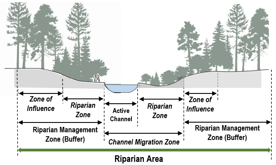
(b) Designation of the Riparian Management Zone.
(i) The provisions in this subsection apply to riparian areas encompassing all F and N water types. Riparian areas encompassing S water types are subject to the shoreline regulations set forth in Chapters 21.70 through 21.77 WMC.
(ii) Within the riparian area, the establishment of a riparian management zone is in accordance with the standard width for the water type set forth in Table 21.51.120(6)(b)(ii), except as may be modified by subsection (6)(b)(iii), (6)(b)(iv) or (6)(b)(v) of this section.
|
Water Type |
Standard Width |
|---|---|
|
Type F |
200 feet |
|
Type Np |
100 feet |
|
Type Ns |
100 feet |
(iii) The width of a Type F water riparian management zone may be reduced to a width of 150 feet if the riparian management zone:
(A) Contains at least an average of 80 percent native plant coverage over the overall area of the riparian management zone;
(B) Noxious and nonnative planting coverage do not exceed 10 percent of the total area of the riparian management zone; and
(C) The native plant cover must include trees, shrubs and groundcover strata in proportions that mimic native forests; and
(D) If the existing riparian management zone does not satisfy the standards in subsections (6)(b)(iii)(A) through (6)(b)(iii)(C) of this section, it must be enhanced to meet these standards to qualify for the 150-foot width.
(iv) The width of a riparian management zone may be increased if greater protection is necessary to preserve functions and values based on site-specific conditions and project features. A requirement to increase the width of the riparian management zone shall be reasonably related to protection of the functions and values of the riparian area based on the following factors:
(A) A designated fish and wildlife habitat conservation area has a habitat management plan indicating a larger riparian management zone is necessary to protect habitat values for such species;
(B) A landslide or erosion hazard area is contiguous to a riparian area;
(C) A larger riparian management zone is necessary to offset impacts such as permitted trails or utility corridors in the riparian area;
(D) The development is within the vicinity of at-risk ecological riparian area functions identified in a critical area report or habitat management plan; or
(E) The increase is in lieu of subsection (6)(d) of this section.
(v) The minimum width of the riparian management zone set forth in subsection (6)(b)(ii) or (6)(b)(iii) of this section may be applied as an average width if approved by the Director and the following conditions are satisfied:
(A) Mitigation sequencing set forth in WMC 21.51.050(1)(b) is followed;
(B) The total area contained within the riparian management zone is no less than what would be contained without the averaging;
(C) The averaging results in equivalent or greater riparian area functions;
(D) The riparian area contains variations in sensitivity due to existing physical characteristics, or the character of the riparian area varies in slope, soils, or vegetation, and the water body would benefit from a wider riparian area in places such as where intact vegetation exists and would not be adversely impacted by a narrower riparian area in other places;
(E) The riparian management zone is not reduced at any point to less than 75 percent of the width set forth in subsection (6)(b)(ii) or (6)(b)(iii) of this section, as applicable;
(F) The riparian management zone is associated with a development proposal, and it will not further encumber a neighboring property not owned by the applicant.
(vi) The width of a riparian management zone is applied to each side of the water course and is measured outward in each direction on a horizontal plane from whichever of the following features is furthest from the center of a stream or river:
(A) The ordinary high-water mark;
(B) The top of bank; or
(C) The outer edge of the channel migration zone, if one exists.
(c) If a portion of a riparian management zone is determined to be functionally isolated and physically separated from a watercourse due to existing, legally established public roadways, railroads or other legally established structures or paved areas eight feet or more in width that occur between the area in question and the watercourse, the Director may exclude this area from a riparian management zone provided:
(i) The area does not provide any of the primary riparian management zone functions of bank stability, shade, pollution control, contributions of detrital nutrients, wildlife habitat corridor connection, or recruitment of large woody debris;
(ii) To the extent feasible, the remaining areas within the riparian management zone are restored or enhanced to achieve a net gain in ecological functions; and
(iii) A critical areas report confirms the area of the riparian management zone as being functionally isolated and physically separated from the watercourse, and subsection (6)(c)(i) of this section is satisfied.
(d) If a riparian management zone is degraded due to the lack of trees and vegetation, the presence of invasive or nonnative species, and/or the presence of impervious surface or other development, the applicant shall prepare and implement a restoration plan that restores the ecological functions of the riparian management zone to the extent commensurate with the impact of the development on the riparian management zone and according to mitigation standards set forth in this chapter.
(e) Activities and uses that may impact a riparian management zone must provide a critical area report pursuant to WMC 21.51.060 that:
(i) Describes the functions and values of the riparian management zone;
(ii) Describes the inner measurement point (e.g., ordinary high-water mark) and the extent of the riparian management zone with sufficient detail to allow field delineation; and
(iii) The critical area report must demonstrate the project will result in no net loss of the ecosystem functions for the riparian management zone and associated species.
(7) Specific Standards for Other Fish and Wildlife Habitat Conservation Areas. Buffers from other fish and wildlife habitat conservation areas are required to be established to protect the functions and values of the critical area from the impacts of proposed adjacent activities.
(a) The establishment of buffers must consider the following:
(i) Recommendations of the Washington Department of Fish and Wildlife;
(ii) Recommendations contained in a habitat management plan submitted by a qualified professional; and
(iii) The nature and intensity of uses and activities occurring on the land adjacent to the site.
(b) The establishment of buffers must incorporate the following:
(i) Consist of an undisturbed area of native vegetation, or areas identified for restoration, sufficient to protect the integrity, functions, and values of the affected habitat;
(ii) Reflect the sensitivity of the habitat and the type and intensity of human activity proposed to be conducted nearby; and
(iii) Be consistent with the applicable species-specific management recommendations issued by the Washington Department of Fish and Wildlife.
(8) Existing Piped Watercourses and Roadside Ditches. It is recognized that within an urban environment many historical streams have been substantially modified to accommodate development. Many of the regulated and mapped watercourses within the City of Woodinville pass through natural reaches, modified reaches, piped reaches, and sometimes along manmade roadside ditches.
(a) Development along a piped streams and manmade ditches shall be subject to a 10-foot setback from the centerline of the pipe or ditch. For purposes of this provision, “ditches” mean artificial drainage features created through purposeful human action, such as irrigation and drainage ditches, grass-lined swales, and canals. Purposeful creation from the uplands must be demonstrated through documentation, photographs, statements, and/or other evidence.
(b) The voluntary opening and restoration or rehabilitation of previously channelized, culverted, or piped streams may have the riparian management zone reduced to a width not less than 25 feet along each side of the new opening provided:
(i) The restoration will result in a net improvement in the ecosystem functions and values of the stream habitat;
(ii) The opened channel must be designed to support fish and wildlife habitat and uninhibited fish access, unless demonstrated to be infeasible;
(iii) The proposal will not significantly increase the threat of erosion, flooding, slope stability or other hazards on the site or on nearby properties; and
(iv) The proposal must demonstrate that the conveyance will maintain the flow capacity and not create flooding elsewhere in the drainage basin.
(9) Existing Urban Stream Designation. If an existing property is at least 50 percent developed and was done so under a previously approved urban stream designation approved by the City, the approved buffer under the urban stream designation may remain in effect and the redevelopment or other modification may be subject to the buffer approved under the urban stream designation; provided, that:
(a) If the urban stream buffer may be negatively impacted by the proposed modifications or activities, the buffer must be enhanced to achieve a no net loss of ecological functions as originally established by the urban stream designation; and
(b) If the existing urban stream designation buffer is degraded due to a lack of maintenance or failure to follow the terms of approving the urban stream designation, the urban stream designation shall be considered abandoned and any redevelopment or other modifications to the property shall be subject to all other provisions of this chapter.
(10) Permitted Uses. The following developments, uses and activities satisfying the specified conditions may be allowed in fish and wildlife habitat conservation areas without the requirement for a reasonable use permit provided such uses and activities do not result in a loss of the ecosystem functions and values of the fish and wildlife habitat conservation area:
(a) Utilities, excluding storm drainage facilities, if:
(i) No practical alternative location outside of the fish and wildlife habitat area is available;
(ii) The location of the utility is the least adversely impactful to the fish and wildlife habitat; and
(iii) The following measures are incorporated into the construction of the utility:
(A) Located in existing areas of clearance with degraded ecological functions whenever possible;
(B) Avoids creating new crossings of fish-bearing watercourses;
(C) Use bio stabilization, riprap, or other innovative engineering techniques to prevent erosion where utilities need to follow landslide hazards;
(D) Does not increase fish passage barriers; and
(E) Promotes utility improvements designed to remove fish and wildlife passage barriers wherever possible.
(b) Storm drainage facilities if:
(i) Conveyance systems that are designed to limit discharge to a watercourse only from a detention facility, pre-settlement pond, or other stormwater treatment facilities, provided discharge to a watercourse is authorized and City stormwater regulations are followed; or
(ii) Grass-lined swales and dispersal trenches that are placed in the outer 25 percent of the buffer width.
(c) Public and private trails and/or visual access designed for nonmotorized traffic if:
(i) The conditions in WMC 21.51.040(8) are satisfied; and
(ii) The surface of the trail uses pervious materials, except a public trail designed for multi-purpose may use impervious materials provided requirements for water quality and quantity control are satisfied; and
(iii) Within a riparian area, the riparian management zone shall be expanded to a minimum distance equal to the width of the trail corridor included within the disturbed areas and the provisions in subsection (6)(c) of this section are not applied.
(d) Alterations to riparian areas, excluding associated wetlands, are permitted, as follows:
(i) For Water Type S, see the shoreline program in Chapters 21.70 through 21.77 WMC.
(ii) Widening of existing roadways where:
(A) The widening is within the outer 25 percent of the riparian management zone;
(B) The widening minimizes impact to the riparian area and provides mitigation consistent with WMC 21.51.070;
(C) The widening does not change the overall stream hydrology;
(D) The widening does not diminish the flood storage capacity of the stream;
(E) Construction consists consistent with the restrictions on work windows required by State and Federal agencies; and
(F) The widening is the minimum necessary to support road functions.
(iii) Active channel crossings if:
(A) Expansion of existing crossings is preferred over creating new crossings;
(B) Crossings shall use bridges or other construction techniques in accordance with best management practices which do not disturb the stream bed, except that bottomless culverts or other appropriate methods demonstrated to provide fisheries protection may be used that disturb the stream bed for Water Type F or Np if it can be demonstrated that such methods and their implementation will pose no harm to the stream or inhibit migration of fish;
(C) Bridge piers or abutments are not placed within the floodway or waterward of the ordinary high-water mark;
(D) Crossings cannot diminish the flood-carrying capacity of the watercourse;
(E) Crossings do not occur over resident or anadromous fish spawning areas;
(F) Construction occurs within the restrictions on work windows required by State and Federal agencies;
(G) Underground utility crossings are laterally drilled and located at a depth of four feet below the maximum depth of scour for the base flood predicted by a licensed civil engineer;
(H) The expansion of existing crossings or the construction of new crossings are the minimum necessary to support transportation goals and policies; and
(I) The materials used to construct the crossing are durable and nontoxic to the maximum extent feasible.
(iv) Excluding Water Type S, active channel relocations if:
(A) The relocation is for enhancing or restoring resources in the riparian area;
(B) The relocation is on site, except off site may be allowed if on-site relocation is not feasible and the off-site location is within the same drainage sub-basin as the original stream;
(C) The relocation follows restrictions on work windows required by State and Federal agencies;
(D) The relocation is not solely to allow for a particular development;
(E) Appropriate floodplain protection measures are employed, and equivalent base flood storage volume and function will be maintained as certified by a qualified civil engineer;
(F) No adverse impact on local ground water will occur;
(G) No increase in velocity will occur upstream or downstream;
(H) No increase in the sediment load will occur upstream or downstream;
(I) Requirements set out in a mitigation plan are satisfied;
(J) Relocation conforms to other applicable laws;
(K) All work will be carried out under the direct supervision of a qualified biologist; and
(L) All required State and Federal permits, and authorization are obtained prior to conducting site work.
(v) For Water Type S, see the shoreline program in Chapters 21.70 through 21.77 WMC.
(vi) Enhancements beyond those permitted pursuant to WMC 21.51.040(10), and not associated with any other development proposal, are allowed if accomplished according to a plan for design, implementation, maintenance and monitoring prepared by qualified professionals and carried out under the direct supervision of a qualified biologist.
(vii) Minor riparian area restoration projects sponsored or approved by a public agency with a mandate to do such work if:
(A) The enhancements are not associated with mitigation of a specific development proposal;
(B) Limited to placement of rock weirs, log controls, spawning gravel, culvert replacement and other specific habitat improvements for resident and anadromous fish including salmonids; and
(C) Performed under the direct supervision of a qualified biologist.
(viii) Removal or modification of existing stream culverts to improve fish passage, stream habitat, and flow capacities.
(ix) Upgrading existing stormwater retention/detention facilities or other existing stormwater management facilities beyond required levels required by the Woodinville Municipal Code.
(11) In addition to the critical area report requirements prescribed in WMC 21.51.060, the following information shall be provided in the critical area report or as a separate report:
(a) A habitat assessment containing an investigation of the project area and an evaluation of the presence or absence of potentially critical fish or wildlife habitat. The habitat assessment shall include at a minimum the following site- and proposal-related information:
(i) Identification of any species of local importance, priority species, or endangered, threatened, sensitive or candidate species that have a primary association with habitat on or adjacent to the project area, and assessment of potential project impacts to the use of the site by the species;
(ii) A discussion of any Federal, State, or local special management recommendations, including Department of Fish and Wildlife Habitat management recommendations that have been developed for species or habitats located on or adjacent to the project area;
(iii) A discussion of any ongoing management practices that will protect habitat after the project site has been developed, including any proposed monitoring and maintenance programs;
(iv) When appropriate due to the type of habitat or species present or the project area conditions, the Director may also require the habitat management plan to include:
(A) An evaluation by the State Department of Fish and Wildlife, local Native American Indian tribe, or other qualified expert regarding the applicant’s analysis and the effectiveness of any proposed mitigating measures or programs, to include any recommendations as appropriate; and/or
(B) Detailed surface and subsurface hydrologic features both on and adjacent to the site.
(b) A riparian management zone delineation report containing at a minimum the following information:
(i) A written assessment and accompanying maps of the watercourse and associated hydrologic features on and off site within 300 feet of the project area that includes the following:
(A) Delineation of the ordinary high-water mark;
(B) The riparian management zone boundary;
(C) Vegetative, faunal, and hydrologic characteristics;
(D) Soil and substrate conditions; and
(E) Topographic elevations at two-foot contours;
(ii) A detailed description and functional assessment of the watercourse channel and riparian management zone under existing conditions pertaining to the protection of the riparian management zone functions, fish habitat, and potential anadromous fisheries;
(iii) A habitat and native vegetation conservation strategy that addresses methods to protect and enhance on-site habitat and riparian management zone functions;
(iv) Proposed riparian management zone enhancement, if needed, including a written assessment and accompanying maps and planting plans for the riparian management zone areas to be enhanced.
(A) A description of existing riparian management zone conditions;
(B) A description of proposed riparian management zone conditions and how proposed conditions will increase riparian management zone functions in terms of fish habitat protection;
(C) Performance standards for measuring enhancement success through a monitoring period of at least five years;
(D) Provisions for monitoring and submission of monitoring reports documenting riparian management zone conditions, as compared to performance standards, for enhancement success; and
(E) A discussion of ongoing management practices that will protect riparian management zone functions and habitat value through maintenance of vegetation density within the riparian management zone.
(c) The applicant may consult with the Director prior to or during preparation of the above reports to have waived or modified the required contents when in the judgment of the Director such modification will still adequately address the potential critical area impacts and required mitigation.
(12) Mitigation.
(a) The alteration of a fish and wildlife habitat conservation area including buffers and riparian areas requires mitigation to be provided consistently with WMC 21.51.070 and shall include:
(i) Achievement of equivalent or greater critical areas ecosystem functions and values than existing, including but not limited to:
(A) Habitat complexity, connectivity, and other biological functions;
(B) Seasonal hydrological dynamics, water storage capacity and water quality; and
(C) Geomorphic and habitat processes and functions;
(ii) Include mitigation for impacts upstream and downstream from the development as appropriate;
(iii) Mitigation shall address each function affected by the alteration to achieve functional equivalency or improvement on a per-function basis; and
(iv) Mitigation should occur in the same sub-drainage basin as the habitat impacted.
(b) Mitigation sites shall be located to achieve contiguous wildlife habitat corridors in accordance with a mitigation plan that is part of an approved critical area report to minimize the isolating effects of development on habitat areas, so long as mitigation of aquatic habitat is located within the same aquatic ecosystem as the area disturbed.
(c) Restoration or mitigation is required as part of a development proposal whereby impacts, either direct or indirect, to the fish and wildlife habitat conservation area occur.
(d) Restoration is required in addition to mitigation when a fish and wildlife habitat conservation area or its buffer is altered in violation of law or without any specific permission or approval by the City. A mitigation plan for the restoration or mitigation, included as part of the critical areas report, shall demonstrate:
(i) Fish and wildlife habitat conservation area is degraded and will not further be degraded by the restoration or mitigation activity;
(ii) Restoration or mitigation will reliably and demonstrably improve the water quality and fish and wildlife habitat;
(iii) Restoration or mitigation will result in no net loss and no significant adverse impact will occur to habitat functions;
(iv) On sites where nonnative vegetation was cleared, restoration shall include installation of native vegetation with a density equal to or greater than the predevelopment site conditions; and
(v) Restoration or mitigation will assist in stabilizing the stream channel.
(e) All restoration and/or mitigation projects for riparian areas shall meet the following:
(i) All work shall be carried out under the direct supervision of a qualified biologist;
(ii) Basin analysis shall be performed to determine hydrologic conditions;
(iii) Natural channel dimensions shall be replicated including its depth, width, length, and gradient at the original location, and the original horizontal alignment (meander lengths) shall be replaced;
(iv) Identical or similar materials shall be used to restore the stream bottom;
(v) Bank and buffer configuration shall be restored to its original condition;
(vi) Channel, bank, and buffer areas shall be replanted with native vegetation which replicates the original vegetation in species, sizes, and densities; and
(vii) Preexisting biologic functions of the stream shall be recreated.
(f) Replacement or enhancement for approved riparian area alterations shall be accomplished on the site unless the applicant demonstrates:
(i) Enhancement or replacement on the site is not possible or on-site opportunities do not have a high likelihood of success due to development pressures, adjacent land uses, or on-site buffers or connectivity are inadequate;
(ii) Off-site location is in the same drainage sub-basin as the original stream; and
(iii) Greater biological and hydrologic functions will be achieved.
(g) Surface Water Management. Surface water management or flood control alterations shall not be considered enhancement unless other functions are simultaneously improved.
(h) Mitigation sites shall be monitored and maintained consistently with this chapter.
(13) Required Signage.
(a) Temporary Markers. The outer perimeter of the wetland or buffer and the limits of those areas to be disturbed pursuant to an approved permit or authorization shall be marked in the field in such a way as to ensure that no unauthorized intrusion will occur and inspected by the City prior to the commencement of permitted activities. This temporary marking shall be maintained throughout construction, and shall not be removed until permanent signs, if required, are in place pursuant to subsection (13)(b) of this section.
(b) Permanent Signs.
(i) As a condition of any permit or authorization issued pursuant to this chapter, City staff may require the applicant to install permanent signs along the boundary of a wetland or buffer.
(ii) Permanent signs shall be made of a metal face and attached to a metal post, or another material of equal durability. The sign shall be worded as follows or with alternative language approved by the City staff:
Fish and Wildlife Habitat Conservation Area
Do Not Disturb.
Contact the City of Woodinville Regarding Uses and Restriction
(iii) Signs must be posted at an interval of one per lot or every 50 feet, whichever is less, and must be maintained by the property owner in perpetuity. (Ord. 784 § 14 (Att. A), 2025)