


Chapter 15.30
AIRPORT SAFETY OVERLAY (ASO)
Sections:
15.30.040 Airport safety overlay zones.
15.30.070 Application requirements.
15.30.010 Purpose.
The airport safety overlay is intended to protect the airspace around the Yakima Air Terminal at McAllister Field and any other state and federal system airports from airspace obstructions or hazards and incompatible land uses in proximity to the Yakima Air Terminal at McAllister Field or other public airport with defined airspace per Federal Aviation Regulations (FAR) Part 77.
Property within the airport safety overlay may be exposed to aircraft noise, vibration, fumes, dust and fuel particulates, as may be inherent in the operation of aircraft, now known or hereafter used for aircraft navigation and flight while using said airspace for landing at, taking off from, or operating within the airport area. (Ord. 2016-029 § 1 (Exh. A) (part), 2016: Ord. 2015-028 § 2 (Exh. A) (part), 2015).
15.30.020 Applicability.
The provisions of this chapter shall apply to all lands, buildings, structures, natural features or uses located within those areas that are defined by the airport overlay district and designated on the Yakima Air Terminal at McAllister Field Part 77 Surfaces map which identifies areas of height limitations and the airport safety overlay zones map shown below as Figure 30-1. (This figure is for illustration purposes only. An accurate depiction of the airport safety overlay zones map can be found on the city’s GIS website, which is maintained by the city’s information systems department.) (Ord. 2016-029 § 1 (Exh. A) (part), 2016: Ord. 2015-028 § 2 (Exh. A) (part), 2015).
15.30.030 Definitions.
The following terms are established for the purpose of protecting the airspace of the Yakima Air Terminal at McAllister Field or any other state and federal system airport:
Figure 30-1: Airport Safety Overlay Zone Map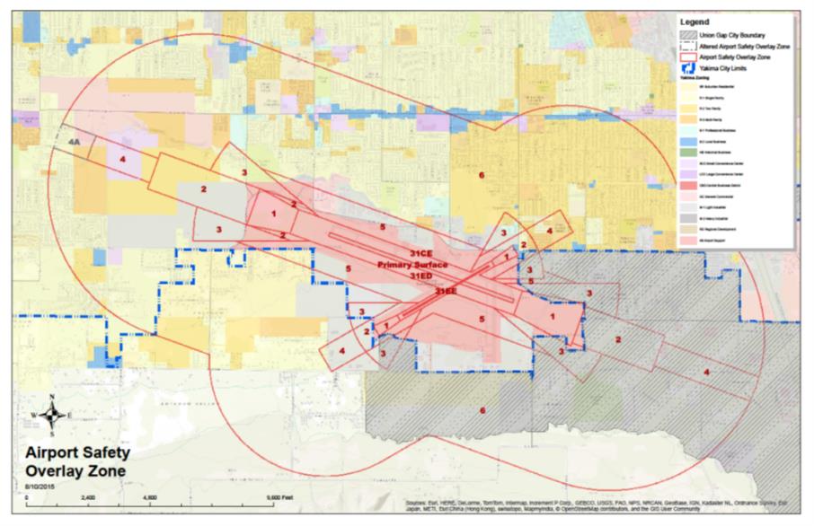
“Airport” means the Yakima Air Terminal at McAllister Field operated by the city of Yakima including all property designated in the Yakima Air Terminal at McAllister Field Master Plan as part of the airport.
“Airport elevation” means the highest point of an airport’s useable landing area measured in feet from sea level. The Yakima Air Terminal at McAllister Field is one thousand forty-nine feet above mean sea level.
“Airport influence area” includes airport property and all land within the airport safety overlay zones 1 through 6 as described in YMC 15.30.040 and depicted in the airport safety zones map adopted in the Yakima Air Terminal at McAllister Filed Master Plan.
“Airport use” means any facility or activity directly associated with the air transportation of persons or cargo or the operation, storage, or maintenance of aircraft at an airport or heliport. Such uses specifically include runways, taxiways, and their associated protected areas defined by the Federal Aviation Administration, together with aircraft aprons, hangars, fixed base operations, terminal buildings, etc. Other uses also include airport commercial, airport industrial, and airport operations, as defined in YMC 15.02.020.
“Approach surface” means an imaginary surface longitudinally centered on the extended runway centerline, extending outward and upward from the end of the primary surface and at the same slope as the approach zone height limitation slope set forth in YMC 15.30.050. The perimeter of the approach surface coincides with the perimeter of the approach zone.
“Conical surface” means an imaginary surface extending outward and upward from the periphery of the horizontal surface at a slope of twenty to one for a horizontal distance of four thousand feet.
“Deed notice” means a formal statement, provided in YMC 15.30.070(D), as a note on the face of a short plat, major subdivision or binding site plan or recorded against the property notifying potential property owners that the property is located adjacent to an active airport and said property may be impacted by aircraft noise, odors, vibration, and low flying aircraft.
“FAA Form 7460-1, Notice of Proposed Construction or Alteration” means a form which the Federal Aviation Administration (FAA) requires to be completed by anyone who is proposing to construct or alter an object that could affect airspace within the airport influence area and allows the FAA to conduct an airspace analysis to determine whether the object will adversely affect airspace or navigational aids.
“FAR Part 77 Surfaces” means the part of 49 CFR of the Federal Aviation Regulations that deals with objects affecting navigable airspace.
“FAR Part 77 Zones” means imaginary airspace surfaces established with relation to each runway of an airport. There are five types of surfaces: (1) primary; (2) approach; (3) transitional; (4) horizontal; and (5) conical.
“Hazard to air navigation” means an obstruction determined to have a substantial adverse effect on the safe and efficient utilization of the navigable airspace.
Height. For the purpose of determining the height limits in all zones and as shown on the Yakima Air Terminal at McAllister Field Future Part 77 Zones map, this datum shall be height above mean sea level elevation unless otherwise specified.
“Horizontal surface” means a horizontal plane one hundred fifty feet above the established airport elevation, the perimeter of which plane coincides with the inner perimeter of the conical surface. This is one thousand one hundred ninety-nine feet above mean sea level for the Yakima Air Terminal at McAllister Field.
“Infill” means the practice of developing or redeveloping vacant or underutilized land in the midst of a community, especially land that is surrounded by existing uses similar to the ones proposed. This may mean further subdivisions of existing parcels to accommodate additional growth, redevelopment of underutilized property to increase its density or intensity, or simply creation of new development on vacant land.
“Nonconforming use” means any use, situation, lot, building or structure that legally existed prior to the adoption of a development regulation that would otherwise prohibit its use.
“Object of natural growth” means a tree, shrub or similar organic or vegetative matter.
“Obstruction” means any object of natural growth, terrain, of permanent or temporary construction or alteration, including equipment or materials used therein which exceeds a limiting height set forth in YMC 15.30.050.
“Precision approach” means a landing approach made without visual reference to the ground by the use of aircraft instruments and ground-based electronic or communications systems or devices. An aircraft making such an approach should be flying in accordance with an IFR (Instrument Flight Rules) flight plan.
“Primary surface” means a surface longitudinally centered on a runway with a width of one thousand feet for instrument approaches and five hundred feet for visual approaches. When the runway has a specially prepared hard surface, the primary surface extends two hundred feet beyond each end of the runway. The elevation of any point on the primary surface is the same as the elevation of the nearest point on the runway centerline. The elevation of the primary surface at the Yakima Air Terminal at McAllister Field is one thousand forty-nine feet above mean sea level.
“Runway” means a defined area on an airport prepared for landing and takeoff of aircraft along its length.
Transitional Surfaces. These imaginary surfaces extend outward at ninety-degree angles to the runway centerline, and runway centerline extended, at a slope of seven feet horizontally for each foot vertically from the sides of the primary and approach surfaces to where they intersect with the horizontal and conical surfaces.
“Visual runway” means a runway intended solely for the operation of aircraft using visual approach procedures, with no straight-in instrument approach procedure and no instrument designation indicated on an FAA-approved airport layout plan. (Ord. 2016-029 § 1 (Exh. A) (part), 2016: Ord. 2015-028 § 2 (Exh. A) (part), 2015).
15.30.040 Airport safety overlay zones.
Zone 1—Runway Protection Zone. This zone encompasses the runway protection zone (RPZ) at each end of the runway and should use the RPZ dimensions established in accordance with FAA standards (RPZ dimensions depend mostly on the visibility minimums for the approach to that runway end). Also included in the zone are the strips of land immediately adjacent to the runway where FAA standards preclude structures. Zone 1 is where the greatest concentration of accidents take place.
Zone 2—Inner Approach/Departure Zone. This zone wraps around and extends beyond zone 1 along the runway centerline. Next to the RPZ, it represents the area where the risk of aircraft accidents is the greatest. On departure, aircraft are typically at full power in the initial phase of climb. On approach, they are at low altitude as they prepare for landing.
Zone 3—Inner Turning Zone. This zone is a wedge-shaped area lying along the sides of zone 2. It is primarily significant at general aviation airports where most of the flights are visual. At airports where most aircraft approach and depart on instrument flight plans, then the close-in turns which are the concern with zone 3 can be a narrow wedge. When operating visually, departing aircraft may begin turning over this area to fly toward their destination or to remain in the traffic pattern. Arriving aircraft often overfly this area as well, especially if they are flying a tight pattern. One type of accident known to occur in this area is a low-altitude stall-spin that can happen if a pilot attempts to make too tight of a turn.
Zone 4—Outer Approach/Departure Zone. This area lies beyond zone 3 along the extended runway centerline. Aircraft flying straight out or in overfly this area at low altitude. The zone is particularly significant on runways where much of the operations are on instrument procedures and at busy airports where elongated traffic patterns are common. The risks in this area are moderate, but less than in zones 1 through 3.
Zone 5—Sideline Zone. Lying in narrow bands along each side of the runway, aircraft do not normally fly over the sideline zone. The principal risk is from aircraft that lose directional control while landing or just after takeoff. The risks are lower than in zones 1 through 3 and similar to those of zone 4.
Zone 6—Traffic Pattern Zone. The final zone contains the remainder of the airport environment where aircraft fly as they approach and depart the airport or are engaged in flight training. In area, zone 6 is typically larger than the other zones combined. A substantial percentage of accidents take place here, but they are scattered over the large area. (Ord. 2016-029 § 1 (Exh. A) (part), 2016: Ord. 2015-028 § 2 (Exh. A) (part), 2015).
15.30.050 Height limitation.
The height limitation zones are hereby established, consistent with the FAR Part 77 Surfaces—Objects Affecting Navigable Airspace, and are described below. All height limitations shall adhere to the FAA approved airport layout plan.
Height Limitation 1 (Zones 1, 2, 3, 4, and 5). No building within this zone shall exceed thirty-five feet above the ground.
Height Limitation 2 (Zone 6). No building within this zone shall exceed thirty-five feet above the ground. Any building proposed to exceed this height must undergo further review by the airport manager and the FAA.
The administrative official may require lights or markers as a warning to aircraft on any building, structure, communication tower, use, or tree(s) or to top the tree to reduce its height when recommended by the FAA, WSDOT Aviation Division or the airport manager. Lights and markers shall meet FAA specifications.
Whenever the height limitations of this section differ from those of any other section of this chapter, or that adopted by another local ordinance or regulation, the more restrictive limitation shall apply. (Ord. 2016-029 § 1 (Exh. A) (part), 2016: Ord. 2015-028 § 2 (Exh. A) (part), 2015).
15.30.060 Land use overlays.
Zones described below are shown in the airport safety overlay zone (ASOZ) map with the types of land use review listed below in order to promote general safety and welfare of properties surrounding the airport and the continued viability of the airport.
Land Use Overlay 1 (Zone 1—Runway Protection Zone (RPZ)):
Only airport uses and activities are allowed within the runway protection zone.
Land Use Overlay 2 (Zones 2, 3, 4, and 4A—Inner Safety Zone, Inner Turning Zone, and Outer Safety Zone):
Class (1) Uses. Any Class (1) use listed in YMC 15.04.030, Table 4-1, Permitted Land Uses, unless otherwise mentioned in this section.
Class (2) Uses. Agricultural building; agricultural related business; animal husbandry; correction facilities; golf courses; campground; gymnasiums, exercise facilities; motels and hotels; canning, preserving, and packaging fruits, vegetables, and other foods; cement and concrete plants; concrete gypsum and plaster products; power generating facilities; utility services; residential infill (within 4A); mixed-use residential (within 4A); cluster development (within 4A).
Class (3) Uses. Agricultural market; junior or community college; business school; vocational school; bed and breakfast inn; communication towers; residential infill; mixed-use residential; cluster development.
Prohibited Uses. Schools (K—12), community centers, nursing home and group homes, day care facilities, hospital, new churches, shopping centers and other uses with similar concentrations of persons, rendering plants and slaughter houses. Other prohibited uses shall be: horse racing tracks, speedways; the production of asphalt paving and roofing materials; rock crushing; fuel storage facilities; storage or use of significant amounts of materials which are explosive, flammable, toxic, corrosive or otherwise exhibit hazardous characteristics; hazardous wildlife attractants including waste disposal operations, water management and stormwater facilities with aboveground water storage, and manmade wetlands.
Zone 4A shall exist as depicted on Figure 30-2 until such time that the airport’s main runway (9/27) is extended as described in the Airport Master Plan. Any Class (2) development which occurs within zone 4A prior to the extension of the runway shall be required, as a precedent condition of approval, to record a deed declaration with the Yakima County auditor which specifically recognizes the preexistence of the airport and the right of aircraft over flight, as well as acknowledging and accepting all responsibility for exposure to noise, vibration, fumes, dust and fuel particulates, as may be inherent in the operation of aircraft. In addition to these conditions, all Class (2) development within zone 4A shall be subject to a recorded deed restriction providing the city with an absolute indemnification with regard to any adverse impacts resulting from or claimed to result from effects of aircraft over flight.
Land Use Overlay 3 (Zone 5—Sideline Safety Zone):
Uses within the sideline safety zone (zone 5) may be permitted by the administrative official if the use is determined to be compatible with the zoning district and Appendix F of the Airports and Compatible Land Use Guidebook of the Washington State Department of Transportation Aviation Division.
Uses labeled as “Permitted” in zone 5 within Appendix F of the Airports and Compatible Land Use Guidebook shall be considered a Class (1) use and undergo any Type (1) review unless a higher level of review is required per YMC 15.04.030, Table 4-1, Permitted Land Uses. Uses labeled as “Limited” or “Limited Special Conditions” in zone 5 within Appendix F of the Airports and Compatible Land Use Guidebook shall be considered a Class (2) use and undergo any Type (2) review unless a higher level of review is required per YMC 15.04.030, Table 4-1, Permitted Land Uses. All uses listed as “Prohibited” in zone 5 within Appendix F of the Airports and Compatible Land Use Guidebook may be permitted as follows:
1. The use is permitted in the underlying zoning district; and
a. For proposals within existing buildings: The use shall undergo Type (2) review unless a higher level of review is required per YMC 15.04.030, Table 4-1, Permitted Land Uses; or
b. For new construction: The use shall undergo Type (3) review;
2. The use has been approved for that specific location by the airport director; and
3. Approval of a prohibited use shall be exclusive to that use alone and not extended to any future proposal for a different prohibited use. The allowance of a prohibited use in one location does not bind the city to allow the same or similar prohibited use in another location.
Figure 30-2: Depiction of Zone 4A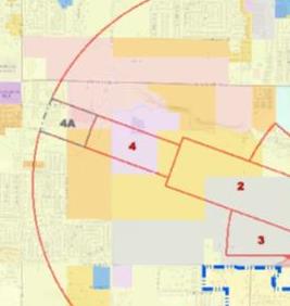
Land Use Overlay 4 (Zone 6—Traffic Pattern Zone):
Class (1) Uses. Any Class (1) use listed in YMC 15.04.030, Table 4-1, Permitted Land Uses, unless otherwise mentioned in this section.
Class (2) Uses. Retirement home; churches, synagogues, temples; convalescent home, nursing home and group homes; day care facilities and centers; correction facilities; communication towers; chemicals (industrial, agricultural, wood, etc.); rendering plants and slaughter houses; power generating facilities.
Class (3) Uses. Amusement park.
Prohibited Uses. Schools (K—12), hospitals and other uses with similar concentrations of persons. Replacement or expansion of existing schools shall be allowed.
Any use not specified in the above paragraphs must undergo review and receive approval from the airport manager. (Ord. 2023-026 § 1 (Exh. A), 2023; Ord. 2016-029 § 1 (Exh. A) (part), 2016: Ord. 2015-028 § 2 (Exh. A) (part), 2015).
15.30.070 Application requirements.
A. Applications for uses within the airport safety overlay established by this chapter shall include the following information:
1. Property boundary lines as they relate to the boundaries of the land use overlay;
2. Location, elevation, and height of all existing and proposed buildings, structures, utility lines, and trees taller than thirty-five feet in height;
3. A description of the proposed use; and
4. A statement of compatibility from the airport manager when the use is to be located within the airport safety overlay relative to the impact of the use on airport operations and safety.
B. In consideration of an application for a building, structure, or other use which will exceed thirty-five feet in height, the administrative official may require the applicant to submit either of the following:
1. A certificate from a registered professional engineer or a licensed land surveyor, which clearly states that no airspace obstruction will result from the proposed use; or
2. Either or both of the following:
a. The maximum elevations of proposed structures based on the established airport elevation and USGS datum. Elevations shall be determined by a registered professional engineer or a licensed land surveyor, accurate to plus or minus one foot, shown as mean sea level elevation or other available survey data. The accuracy of all elevations shall be certified by the engineer or surveyor.
b. A map of topographic contours with not more than five-foot intervals, showing all land within one hundred feet of the proposed structure(s) for which the permit is being sought. This map shall also bear the verification of a licensed land surveyor or registered professional engineer.
C. Decisions by the administrative official may be appealed in accordance with YMC Chapter 15.16.
D. An aviation easement and deed declaration, which recognizes the preexistence of the airport and the right of over flight, shall be recorded for all uses within the approach and transitional surfaces of the conical surface area. (Ord. 2016-029 § 1 (Exh. A) (part), 2016: Ord. 2015-028 § 2 (Exh. A) (part), 2015).
15.30.080 Nonconforming uses.
Existing uses that do not meet these standards at the time of adoption of this overlay may remain and will be considered nonconforming uses. Expansion of these uses is permitted through Chapter 15.19 YMC. For a use that is nonconforming due to height, the height may not be increased unless approved by the airport manager. (Ord. 2016-029 § 1 (Exh. A) (part), 2016: Ord. 2015-028 § 2 (Exh. A) (part), 2015).