


Chapter 17.98
MODIFIED SUBURBAN OVERLAY DISTRICT
Sections:
17.98.010 Statement of purpose.
17.98.020 Overlay district in relation to other zoning.
17.98.030 Overlay district requirements.
17.98.040 Matrix identifying standards for each zoning issue area.
17.98.050 Specific zoning overlay areas.
17.98.060 Parking setback overlay district.
17.98.010 Statement of purpose.
The purpose of the modified suburban overlay district is to supersede certain provisions of base zoning in certain areas when other available zoning tools or other techniques cannot achieve desired results with standards to protect unique development, building or land use patterns in residential, commercial or mixed-use areas when such patterns are not adequately addressed by applicable zoning regulations; promote reinvestment and redevelopment in residential, commercial, or mixed-use areas where change is desired and when existing zoning regulations hinder achievement of the desired change; or help implement neighborhood plans or planning studies. (Ord. 2577-19 § 1, 2019; Ord. 1692 § 1 (part), 1999)
17.98.020 Overlay district in relation to other zoning.
Each modified suburban overlay district may be used to relax or eliminate requirements of the base zoning districts or to impose additional requirements than those stated in the base zoning district. Where conflict occurs among two or more overlay districts applicable to the same property, the most restrictive of the conflicting provisions prevails. (Ord. 2577-19 § 2, 2019; Ord. 1740 § 1 (part), 2000: Ord. 1692 § 1 (part), 1999)
17.98.030 Overlay district requirements.1
Whenever this overlay district is applied to a particular geographic area, the common council will adopt a map or map series showing the geographic extent of the overlay district, the zoning issue area, planning unit, and any parcel(s) within each overlay zoning district. The associated map is considered a supplement document adopted and incorporated herein by reference. The common council will also set forth the permitted uses, if different than the base zoning, and particular standards for each overlay district; the standards may include, but are not limited to, the size, scale, and height of buildings, hours of operation, traffic control, noise control, lighting, odor control, impervious surface coverage, and landscaping.
A. Development Patterns. New development and redevelopment of properties designated as having a development pattern of new suburban (NS), cluster suburban (CS), combination (CS/NS), residential cluster (RC), context suburban (CTS), or traditional neighborhood development (TND) will be required to achieve the following design characteristics, summarized here and described more specifically for each geographical area.
1. Cluster Suburban. A development pattern where buildings are positioned and clustered on a site in a manner that creates a well-defined pedestrian environment between building entrances. Minimal parking is located in the area between the building cluster and the street (a maximum of a double-row of parking). Cluster suburban acknowledges that most people will drive in their autos to destinations, but will seek to walk between buildings in the cluster area. The development style minimizes the auto-oriented environment along the street and configures buildings to encourage pedestrian usage. The street-side and pedestrian-side building facades convey human scale through fenestration, articulation, detailing or landscape plantings.
2. New Suburban. A development pattern where buildings are oriented toward the street with at least one major pedestrian entrance connected to the street/pedestrian way. No parking is located in the area between the building and the street. A well-defined pedestrian environment is developed between the edge of the street and the street-side facade of the building. While most people will drive their autos to destinations in a new suburban development, greater opportunities for pedestrian access to sites will be created. The street-side building facade conveys human scale through fenestration, articulation, detailing or landscape plantings.
3. Residential Cluster. A residential development pattern characterized by a unified site design for a number of housing units, clustering buildings and providing common open space, potential density increases, and a mix of building types. It permits the planning of a project and the calculation of densities over the entire development, rather than on an individual lot-by-lot basis. Where sites with this development pattern are adjacent to sites planned for a new suburban or cluster suburban development pattern, street yard building setbacks shall approximate those called for in those development pattern standards.
4. Context Suburban (CTS). A development pattern in which development or redevelopment on a parcel that is within a neighborhood context of relatively newer or historic buildings may develop consistent with the building layout and parking layout of the neighborhood context.
5. Traditional Neighborhood Development (TND). A development pattern consisting of a compact, mixed-use neighborhood where residential, commercial and civic buildings are in close proximity to each other, as defined in Section 66.1027(1)(c), Wisconsin Statutes. This development pattern is created by title only to indicate intent of the city to conform with the requirements of the state law. The development pattern may be able to be achieved under one or more of the other development patterns defined in this section or additional development pattern provisions may be incorporated by later amendments, consulting with a document identified as “Model Ordinance for Traditional Neighborhood Development,” dated December, 2000, published by the University of Wisconsin – Extension pursuant to Section 66.1027(2), Wisconsin Statutes, as a nonexclusive and nonbinding guide to the form of development.
6. Combined Development Patterns. Where properties are designated in the matrix found in the following Section 17.98.040 as having a combination of development patterns, the plan commission will allow a combination of patterns within a single site or within a planning unit as defined herein.
7. Standards for the Removal of a Development Pattern Designation. The plan commission may, after finding that a development pattern designated in a matrix for the nonresidential use of a specific property does not serve in the best interests of the community due to the proximity of the residential properties and the existence of certain conditions including, but not limited to, topography, lot size, lot depth, or the impact of a permitted intensive use on adjacent residential properties, recommend that the common council remove the development pattern designation through an amendment to the matrix and removal or amendment of the associated map as needed.
B. Dimensional Standards.
1. As necessary, the development pattern designations will require site plans with dimensional characteristics different than those required by the underlying base zoning. The application of this overlay district constitutes authorization to the plan commission to modify dimensional requirements of underlying base zoning to achieve the purposes and the intent of the development patterns.
The following set of illustrations shows how such modifications may be made to achieve certain standards of the development patterns:
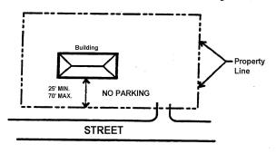
a. Building Setbacks from Streets for “New Suburban” Development. Twenty-five (25) foot2 minimum to seventy (70) foot maximum setback along a street for “new suburban” frontage where a single building is located on an individual lot. Where building clusters are developed on larger lots, the minimum and maximum building setbacks apply only to the building adjacent to street, but the number of buildings set back more than the minimum twenty-five (25) feet or a setback close to twenty-five (25) feet will be minimized.
b. Building Setbacks from Streets for “Cluster Suburban” Development. Twenty-five (25) foot minimum and seventy (70) foot maximum setback if no parking is located in the space between the building and the street. Seventy-five (75) foot minimum (single loading parking) and a one hundred twenty-five (125) foot maximum (double loaded parking) setback when parking is located in such space. Where building clusters are developed on larger lots, the minimum and maximum building setbacks apply only to the buildings adjacent to street, but the number of buildings set back more than the minimum of seventy-five (75) feet or a setback close to seventy-five (75) feet will be minimized.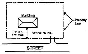
c. Parking Offset. A minimum of twenty-five (25) feet shall be maintained from back of curb (parking lot) to rear and/or side lot line when commercial use adjoins any residential district, except for intensive uses as regulated elsewhere in this code where greater separations are required. This space shall be developed as a landscaped feature. Minimum height of the landscape buffer shall be three feet. Design specifications are found within the Site Development Standards for Nonresidential Uses.
d. Landscape Design. Allow parking lot “planting islands” to be consolidated (normally one planting island per twenty (20) parking spaces is required) to create larger landscaped areas within parking lots. Minimum dimensions for the consolidated planting islands shall be twelve (12) feet wide from back of curb to back of curb. Islands shall be a minimum of one hundred twenty (120) feet long to achieve maximum visual effect and plant massing.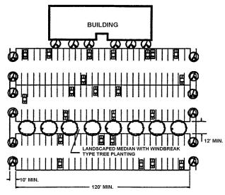
2. The dimensional standards in areas designated as Context Suburban (CTS) Development Pattern may be established by the city to establish reasonable consistency with the siting and other dimensional characteristics of relatively newer or other buildings in the contextual vicinity. The diagram below shows one illustration.
3. The matrix will also show dimensional standards that are not related to Development Patterns.
4. Transfer of Development Rights. If listed within the matrix for the district, the available floor area or lot coverage assigned under the base zoning of a zoning issue area (“sending site”) can be transferred to another zoning issue area (“receiving site”) located within the planning unit or adjacent planning unit provided there is a corresponding reduction in available floor area and lot coverage on the sending site. In addition, a reduction in landscape surface ratio can be established on the receiving site provided there is a corresponding increase in landscape surface ratio on the sending site.
C. Uses Allowed or Disallowed.
1. Where indicated in the matrix, the overlay district allows specified uses in addition to those allowed in the underlying base zoning throughout the overlay district.
2. Where specified in the matrix, the overlay district disallows uses that otherwise would be allowable by the underlying base zoning throughout the overlay district.
3. The allowance of a use by the base zoning or the use provisions of the overlay district does not exempt new development or redevelopment of a particular use from complying with the other requirements of the overlay district, such as those dealing with site development standards, intensive use, or conditional use requirements.
D. Planning Units and Nodes. Within the Section 17.98.040 matrix, planning units are depicted on the map series associated with the applicable MSO district. Such planning units may contain a node identified in the city comprehensive plan.
E. Special Characteristics. This portion of the matrix defines other standards for the associated MSO district.
F. Additional Standards. In addition to any standards set forth in this chapter, all nonresidential site plans shall comply with the most recent edition of the Site Development Standards for Nonresidential Uses. If a conflict occurs between the language of the Site Development Standards for Nonresidential Uses and this chapter, the language of this chapter shall control. (Ord. 2732-20 § 5, 2020; Ord. 2577-19 § 3, 2019; Ord. 2450-16 § 1, 2016; Ord. 1965-04 §§ 1, 2, 2004; Ord. 1872 § 1, 2002; Ord. 1820 § 1, 2001; Ord. 1740 § 1 (part), 2000; Ord. 1692 § 1 (part), 1999)
17.98.040 Matrix identifying standards for each zoning issue area.
The modified suburban overlay district incorporates a single, uniform description of regulations. The descriptions are found in the matrices for specific geographic areas as listed in a supplement document adopted and incorporated herein by reference. The city ordinances that applied the district regulations to specific geographic areas are listed as follows:
|
Ord. 1692 |
(Original MSO Ordinance – Creating Section 17.98 of Municipal Code.) Creating a Modified Suburban Overlay Zoning District and Applying said District to Certain Properties in the Capitol Drive Corridor. The MSO is depicted on maps available here and at the city clerk’s office and community development office. |
|
Ord. 1693 |
Rezoning Certain Properties Within the Capitol Drive Corridor as Part of Implementing the Capitol Drive Land Use Plan – 1999 and Extending a Moratorium on Certain Additional Properties. |
|
Ord. 1740 |
A Rezoning of the Base Zoning from “B-1” Local Business to “B-2” General Business and a Revision of the Modified Suburban Overlay Zoning District for the DeRosa Property Located at the Northeast Corner of North Avenue and Pilgrim Square Drive. |
|
Ord. 1820 |
Revision of the Modified Suburban Overlay Zoning District – Context Suburban. |
|
Ord. 1822 |
Ordinance Rezoning Lands Owned by Covenant Health Care and Netzow Limited Partnership from “B-1” Local Business District and “R-2” Single-Family Residence District to “O” Office District with “MSO-CTS” Modified Suburban Overlay-Context Suburban. |
|
Ord. 1872 |
Ordinance Amending Section 17.98.030 Overlay District requirements of the Modified Suburban Overlay District to Add a Traditional Neighborhood Development (“TND”). |
|
Ord. 1879 |
Ordinance Rezoning 3705 N. 124th Street from “I” Industrial to “B-3” Regional Business (Base) and “CS” Cluster Suburban/“NS” New Suburban (Overlay) Districts, to Construct a New Mixed-use Commercial Building and Renovate an Existing Building. |
|
Ord. 1883 |
Rezoning Certain Properties to the Planned Development District-Mixed Use No. 6 Capitol Heights and Modifying the use variations and Special Characteristics of the “MSO” District Applicable to said Properties. |
|
Ord. 1906-03 |
Revision of the Modified Suburban Overlay Matrices contained in Ordinance No. 1692, for the property located at 17900 W. Capitol Drive or a proposal known as Woodberry Village. |
|
Ord. 1962-04 |
Revision of the Modified Suburban Overlay Matrices Contained in Ordinance No. 1692, for the Property Located at 17295 W. Capitol Drive or Pick ’N Save (Roundy’s Inc.) |
|
Ord. 1965-04 |
An Ordinance Amending Portions of the Zoning Code, Section 17.98.030 Modified Suburban Overlay District, Relating to Overlay District Requirements. |
|
Ord. 1966-04 |
Rezoning Certain Properties from “B-1” Local business to Planned Development District-Commercial, No. 11, to Construct Approximately 12,370 Square Feet of Retail space for a Proposed Gas Station and Retail Development Located at 3970 and 3980 N. Brookfield Road; and Amending the Zoning issue Area C18 of the “MSO” Modified suburban Overlay District Matrix, including the Removal of the “CS” Cluster Suburban Development Pattern Designation. |
|
Ord. 1977-04 |
Revision of the Modified Suburban Overlay Matrices contained in Ordinance No. 1692, for the property located at 14335 West Capitol Drive. |
|
Ord. 1979-04 |
Ordinance Zoning 4235 N. Brookfield Road “MSO-RC” and Rezoning Parcel 1, CSM No. 5459 from “O&LI” with “MSO-CS” to “R-3” and “C” with “MSO-RC” and Amending the MSO Matrix of Ordinance No. 1693, Changing the Development Pattern of Zoning Issue Area WC1 in the MSO Matrix of Ordinance No. 1693 from CS to RC/CS. |
|
Ord. 1991-04 |
Revision of the Modified Suburban Overlay Matrix contained in Ordinance No. 1692, for the property located at 18900 West Capitol Drive and to Establish a Special Exception for Automobile Dealerships Designation for the Land. |
|
Ord. 2016-05 |
Revision of the Modified Suburban Overlay Matrices contained in Ordinance No. 1692, for the property located at 14035 West Capitol Drive (Trieglaff Mobil). |
|
Ord. 2046-06 |
Rezoning certain properties from “M-2” Multiple-Family District and “R-3” Single-Family District to Planned Development District-General Plan (Mixed Use), No. 12, for the purpose of constructing “Fairview Centre,” an approximate 38,345 sq. ft. commercial building and two multiple-family buildings, containing a total of 36 dwelling units; and amending the zoning issue area C6 of the “MSO” Modified Suburban Overlay District Matrix, and acknowledging in the use variations column that “low intensity restaurant” as defined in Chapter 17 of the municipal code is a local business use. |
|
Ord. 2048-06 |
Rezone 18305 and 18345 Davidson Road “MSO-RC” modified suburban overlay-residential cluster to permit construction of Erbary Place, 7 single-family, detached condominiums. |
|
Ord. 2053-06 |
Rezone 18315 and 18415 Hoffman Avenue “MSO-RC” Modified Suburban Overlay Residential Cluster to Permit Construction of Hoffman House Town Homes, permitting two, four unit residential buildings. |
|
Ord. 2062-06 |
Revision of the Modified Suburban Overlay Matrices contained in Ordinance No. 1692, for the property located at 14640 West Capitol Drive (Eddie Z’s Blinds and Drapery). |
|
Ord. 2072-06 |
Revision of the Modified Suburban Overlay Matrix Contained in Ordinance No. 1692, for the property located at 18380 West Capitol Drive (Spheeris Office/PANDL Restaurant). |
|
Ord. 2075-06 |
Revision of the Modified Suburban Overlay Matrix Contained in Ordinance No. 1692, for the property located at 14570-14620 West Capitol Drive (CP Capitol I/Avian of Brookfield). |
|
Ord. 2098-07 |
Rezone 18550 through 18650 Kamala Court (Units A through C) Modified Suburban Overlay-Residential Cluster (MSO-RC) for Colonial Heights Condominiums permitting construction of three new, two-dwelling unit condominium buildings. |
|
Ord. 2133-08 |
Establishment of the Modified Suburban Overlay Zoning District-Context Suburban Development Pattern (“MSO-CTS”) and Matrix for the property located at 225 S. Executive Drive, Lattos Land LLC. |
|
Ord. 2165-09 |
Establish “MSO-CS” Modified Suburban Overlay District – Cluster Suburban zoning for the construction of a 129-room extended stay hotel at 555 S. Executive Drive, Hyatt Summerfield Suites. |
|
Ord. 2175-09 |
Establish “MSO-RC” Modified Suburban Overlay District – Residential Cluster zoning for the construction of the Glen of Brookfield, a 46-unit condominium with clubhouse located at approximately 15275 Hackberry Lane. |
|
Ord. 2201-10 |
Establish “MSO-CS” Modified Suburban Overlay – Cluster Suburban district zoning to facilitate the construction of a 4,532-square-foot single-tenant retail store at 17000 W. Bluemound Road (Brookfield Fashion Center) for the purpose of defining the landscape and surface ratio, floor area ratio, and setbacks along Bluemound Road and Thomas Lane. |
|
Ord. 2219-10 |
Rezone the former Fire Station #3 city block located at the northeast corner of Moorland Road and Hackberry Lane from “R-3” single-family residential to “O&LB” office and limited business/“MSO” Modified Suburban Overlay and remove conditional use Ordinance #746 that designated a portion of this block as a fire station site. |
|
Ord. 2237-10 |
Revising the preclusion on auto dealer use or auto service uses as listed in the use variations column of the modified suburban overlay matrix in Ordinance No. 1692 for zoning issues area W.C.1, as well as approving a special exception permitting expansion of an existing automobile dealership onto a new parcel at 4085 N. Brookfield Road. |
|
Ord. 2267-11 |
Revising the Modified Suburban Overlay use variations and characteristics matrix to allow multiple restaurant types in Issue Area E.1 of the Capitol Drive Corridor Plan or the southwest corner of 124th Street and Capitol Drive. |
|
Ord. 2322-13 |
Amendment of the Modified Suburban Overlay matrix contained in Ordinance No. 2075-06, allowing for construction of two-story residential dwellings rather than ranch-style dwellings at Wyndham Pointe Condominiums |
|
Ord. 2326-13 |
Establish “MSO-CS” Modified Suburban Overlay District – Cluster Suburban development pattern, dimensional standards and special characteristics at 3305 N. 124th Street in association with a revised plan and method of operation permitting parking lot alteration and an approximate 7,632 sq. ft. building addition to be occupied by a natural/organic food store |
|
Ord. 2369-14 |
Ordinance granting a special exception and amending “MSO” Modified Suburban Overlay Ordinance No. 1991-04 establishing the “CTS” Context Suburban Development Pattern and building setback special characteristics in association with an approximate 19,982 sq. ft. building expansion of an automobile dealership at 18900 W. Capitol Drive, Soerens Ford. |
|
Ord. 2381-14 |
Amending the City of Brookfield 2035 Comprehensive Plan Map 1: Future Land Use as it pertains to 13785 W. North Avenue and the vacant parcel adjacent thereto, i.e., Tax Key No. 1102-998-001, changing the land use recommendation from Housing Focused – Lower Density to Shopping/Services Focused – Lower Density and rezone from “R-2” Residence District to “B-1” Local Business District with “MSO-CTS #1” Modified Suburban Overlay – Context Suburban development pattern. |
|
Ord. 2388-14 |
Amending Ordinance No. 2381-14 to modify “MSO-CTS” Modified Suburban Overlay – Context Suburban Development pattern in association with a proposed 13,287 sq. ft. (new) two-story office building at 13785 W. North Avenue (Marian Mleczko). |
|
Ord. 2392-14 |
Amending the City of Brookfield 2035 Comprehensive Plan Map 1: Future Land Use as it pertains to a portion of property known as Plaza 173 or 17300 W. Bluemound Road, rezoning a portion of said property from “M-2” Multiple-Family Residential to “B-3” Regional Business District and establishing the “MSO” Modified Suburban Overlay on the entirety of property. |
|
Ord. 2400-14 |
Repealing special exception Ordinance No. 1235, repealing conditional use Ordinance No. 2214-10, and rezoning to establish the Modified Suburban Overlay – Context Suburban Development pattern in association with an approximate 49,879 sq. ft., three-building, multi-tenant development at 17100 W. Greenfield Avenue (St. John Properties). |
|
Ord. 2406-15 |
Ordinance amending the City of Brookfield 2035 Comprehensive Plan Map 1: Future Land Use as it pertains to vacant properties with tax key numbers of 1010-979, 1011-985 and 13635 Lisbon Road, i.e., Tax Key No. 1010-978, changing the land use recommendation from Housing Focused – Lower Density to Housing Focused – Medium Density, rezoning the base zoning of said site from “R-2” and “R-3” Single-Family Residence District to “M-2” Multiple-family Residence District, establishing the “MSO-RC” Modified Suburban Overlay – Residential Cluster development pattern and adjusting the “C” Conservancy Zoning District for compliance with field delineated wetland boundaries for the purpose of constructing the Glen at Woodside Creek. |
|
Ord. 2410-15 |
Establishing permanent zoning on lands annexed by Ordinance No. 2379-14 from the Town of Brookfield (BLR/Willkomm). |
|
Ord. 2415-15 |
Ordinance amending the City of Brookfield 2035 Comprehensive Plan Map 1: Future Land Use as it pertains to 13615 Lisbon Road, changing the land use recommendation from Housing Focused – Lower Density to Housing Focused – Medium Density, rezoning the base zoning of said site from “R-3” Single-Family Residence District to “M-2” Multiple-Family Residence District with “MSO-RC” Modified Suburban Overlay – Residential Cluster development pattern and amend Ordinance No. 2406-15 for the purpose of expanding the Glen at Woodside Creek, from a 70 dwelling unit, single-story condominium development to a 76 dwelling unit, single-story condominium development. |
|
Ord. 2416-15 |
Amending the City of Brookfield 2035 Comprehensive Plan Map 1: Future Land Use designation as it pertains to 13220 and 13300 W. Capitol Drive from “Employment Focused – Low Density” to “Shopping/Services Focused – Low Density” and changing the future land use designation of 4025 N. 133rd Street from “Housing Focused – Low Density” to “Shopping/Services Focused – Low Density.” Included is a rezoning of 13220 and 13300 W. Capitol Drive from “O” Office with “MSO-NS” Modified Suburban Overlay – New Suburban Development Pattern to “B-1” Local Business District and adding the “CS” Cluster Suburban Development Pattern; and rezoning of 4025 N. 133rd Street from “R-2” Single-Family Residential to “B-1” Local Business District with “MSO-NS/CS” Modified Suburban Overlay – New Suburban/Cluster Suburban Development Pattern (City Lights and Fans). |
|
Ord. 2432-15 |
Ordinance rezoning 17495 W. Capitol Drive from “B-1” Local Business to “B-3” Regional Business and amend MSO Ordinance No. 1693 to modify use variations and special characterizations (GenCap Sun Prairie/Capitol Plaza West). |
|
Ord. 2449-16 |
Ordinance establishing a Modified Suburban Overlay district (“MSO”) upon three parcels of land located at 13135 W. Lisbon Rd., 12905 W. Lisbon Rd., and 12930 W. Lisbon Rd. for purposes of accommodating building additions and adding parking; and also establishing a Modified Suburban Overlay District (“MSO”) upon two City owned parcels of land located north of Lisbon Road (BRC TKN 1012-999-012 and 1012-999-014) for purposes of transferring open space to other parcels located in the associated or adjacent planning unit (Milwaukee Tool Corporation). |
|
Ord. 2451-16 |
Ordinance amending the Modified Suburban Overlay District (“MSO”) upon a parcel of land located at 13135 W. Lisbon Road, for purposes of accommodating a zero (0) foot pavement offset along the east lot line of said parcel (Milwaukee Tool Corporation). |
|
Ord. 2454-16 |
Ordinance repealing special exception Ordinance No. 1483 and amend Modified Suburban Overlay Ordinances Nos. 1692 and 1693 as they pertain to development patterns, use variations and special characteristics at 4005 and 4025 N. 124th Street as well as 12400, 12430 and 12460 W. Capitol Drive as a precursor to a three lot Certified Survey Map and new plan and method of operation permitting redevelopment of or incorporation of the aforementioned addresses into a unified site plan with construction of two new commercial buildings (Boulder Venture). |
|
Ord. 2481-17 |
Ordinance granting a conditional use and rezoning permitting recreational use, assisted living/memory care use, establishing the “MSO” Modified Suburban Overlay Zoning District and repealing conditional use Ordinances No. 400 and 453 at 16050 and 16100 W. Greenfield Avenue in association with construction of an approximate 116,200 sq. ft. (gross) memory care/assisted living building and creation of a city owned/operated neighborhood park site (Caddis Acquisition). |
|
Ord. 2508-18 |
Ordinance establishing Modified Suburban Overlay zoning in addition to the Industrial zoning district of the Brookfield Industrial Park and the properties abutting Enterprise Avenue, Commerce Avenue, and Industry Avenue. |
|
Ord. 2510-18 |
Ordinance establishing the Modified Suburban Overlay-New Suburban, Cluster Suburban, Context Suburban development pattern zoning designation in association with a gas station canopy with 30’ setback where a 100’ setback is required in the base zoning district located at 3075 N. 124th Street (Brookfield Real Estate Holdings). |
|
Ord. 2512-18 |
Ordinance rezoning 18870-19100 North Hills Drive from “M-1” Residence District to “M-2” Residence District with “MSO-RC” Modified Suburban Overlay-Residential Cluster, “R-3” Residence District with “MSO-RC” Modified Suburban Overlay-Residential Cluster and “VAB” Village Area Business District in association with an existing multiple-family development, a new single-family residential subdivision and relocation for commercial/civic occupancy of the CP Rail Depot (Leitermann/CP Rail Depot/Fiddleheads). |
|
Ord. 2522-18 |
Ordinance applying the Modified Suburban Overlay – Context Suburban Zoning designation to 150 N. Patrick Boulevard. |
|
Ord. 2543-19 |
Ordinance amending Exhibit “A” of Modified Suburban Overlay (MSO) Ordinance #2454-16 adding free-standing, fast food with drive-thru to the use variations column of said ordinance in association with a proposed Taco Bell restaurant on a vacant lot at the southwest corner of Lisbon Road and 124th Street, Tax Key No. 1012-084-001. |
|
Ord. 2593-20 |
Amending Section 17.98.050 of the Brookfield Municipal Code creating the Northern Brookfield Square Area Overlay and the Northern Executive Drive Area Overlay areas and their respective regulations and design standards; Listing the Certain Properties to Which These Overlays Apply; and Rezoning the Property Located at 205 N. Moorland Road from “B-3” Regional Business to “O&LR/C #2” Office and Limited Residential/Commercial No. 2 with Modified Suburban Overlay Zoning District. |
|
Ord. 2594-20 |
Amending Section 17.98.050 of the Brookfield Municipal Code Creating the Southern Brookfield Square Area Overlay and the Southern Executive Drive Area Overlay areas and their respective regulations and design standards; and Listing the Certain Properties to Which These Overlays Apply. |
|
Ord. 2610-20 |
Creating the Civic Center Area Overlay Zoning District, Applying the District to Certain Properties, Amending the 2050 Brookfield Comprehensive Plan, Rezoning Land at 17115 West North Avenue from “B-3” to “B-1,” and Granting a Conditional Use for Development in the Floodplain at 17115 West North Avenue. |
The district created by adoption of the ordinance codified in this section applies to the properties specifically identified in the matrices and map series identified by the city ordinances listed above; said matrices and map series being adopted by reference as part of this chapter as if included herein.
The full text of the area-specific ordinances, matrices and map series is available by clicking on the ordinance number in the respective hyperlink above, e.g., 2543-19. (Ord. 2732-20 § 5, 2020; Ord. 2622-20 § 4, 2020; Ord. 2610-20 § 4, 2020; Ord. 2594-20 § 6, 2020; Ord. 2593-20 § 5, 2020; Ord. 2577-19 § 4, 2019; amended during Supp. No. 22, 8-2008; amended during Supp. No. 19, 8-2007; amended during Supp. No. 18, 5-2007; amended during Supp. No. 17, 2-2007; amended during Supp. No. 16, 11-2006; amended during Supp. No. 15, 5-2006; amended during Supp. No. 14, 2-2006: Ord. 1991-04 Exh. C, 2004; Ord. 1962-04 Exh. A, 2004; Ord. 1778 § 16 (part), 2001; Ord. 1745 §§ 1 (part), 2, 2000: Ord. 1744 §§ 1 (part), 2, 2000: Ord. 1740 §§ 1 (part), 2, 2000: Ord. 1692 § 1 (part), 1999)
17.98.050 Specific zoning overlay areas.
A. The following sets forth the uses, standards, and requirements for specific overlay areas. The areas listed in this section are not subject to the provisions of Sections 17.98.030 and 17.98.040.
1. Brookfield Square Area Overlay. The Brookfield Square planning unit is depicted on a map available here and at the city clerk’s office and community development office. The following uses, standards, and requirements apply to this overlay:
a. Objectives.
i. Long-Term Value and Quality. By achieving uniformity in design expectations, the value of public and private investment can be sustained through the creation of a quality environment.
ii. Design. To achieve a design aesthetic of urban form and character through guiding high quality architecture and construction with attention to placement, relationship and orientation of structures to provide a greater sense of place.
iii. Compact Mixed Use. To create a compact concentration of multiple land uses that generate the critical mass necessary to achieve economic stability and vitality of the area.
iv. Pedestrian Oriented. While it is recognized that automobiles play a pivotal role in the use of the area, these standards aim to lay the framework to reduce the complete dependence upon and dominance of the automobile through street design, shared parking, pedestrian scaled buildings, pathways and spaces.
v. Public Space. To preserve, enhance, or create many forms of publicly accessible open space, such as plazas, tree-lined streets and community gathering areas.
vi. Street Activity. To encourage a sense of place through street-level activity by allowing the imaginative and efficient utilization of land. To develop a sense of community by promoting year-round pedestrian and outdoor activities at the street level.
b. Building setback to public street: twenty-five (25) feet.
c. Building offset: zero feet.
d. Pavement setback to public street: zero feet.
e. Pavement offset: zero feet.
f. Landscape/surface ratio: two percent or the minimum area required to comply with Chapter 14, whichever is more restrictive.
g. Lot coverage: ninety-eight (98) percent or the minimum area required to comply with Chapter 14, whichever is more restrictive.
h. Floor area ratio: maximum 1.0.
i. Building height: maximum one hundred (100) feet.
j. Dumpster setback: twenty-five (25) feet.
k. Building Placement. The location of a building shall create a sense of urban enclosure, such as a courtyard or a defined corridor, that enhances the relationship between door and window openings and other entries and the public or private street to strengthen the pedestrian experience.
l. The permitted uses are those permitted in the office and limited residential/commercial district No. 2.
2. Southern Brookfield Square Area Overlay. The Southern Brookfield Square planning unit is depicted on a map available here and at the city clerk’s office and community development office. The following uses, standards, and requirements apply to this overlay:
a. Objectives.
i. Long-Term Value and Quality. By achieving uniformity in design expectations, the value of public and private investment can be sustained through the creation of a quality environment.
ii. Design. To achieve a design aesthetic of urban form and character through guiding high quality architecture and construction with attention to placement, relationship and orientation of structures to provide a greater sense of place.
iii. Compact Mixed Use. To create a compact concentration of multiple land uses including hospitality, office, and residential land uses and structured parking that generate the critical mass necessary to achieve economic stability and vitality of the area.
iv. Pedestrian Oriented. While it is recognized that automobiles play a pivotal role in the use of the area, these standards aim to lay the framework to reduce the complete dependence upon and dominance of the automobile through street design, shared parking, pedestrian scaled buildings, pathways, and spaces.
v. Public Space. To preserve, enhance, or create many forms of publicly accessible open space, such as plazas, tree-lined streets, and community gathering areas.
vi. Street Activity. To encourage a sense of place through street level activity by allowing the imaginative and efficient utilization of land. To develop a sense of community by promoting year-round pedestrian and outdoor activities at the street level.
b. Building setback to public street: twenty-five (25) feet.
c. Building offset: ten feet or the distance required by Chapter 8.08, whichever is more restrictive.
d. Pavement setback to public street: fifteen (15) feet.
e. Pavement offset: zero feet.
f. Landscape/surface ratio: ten percent or the minimum area required to comply with Chapter 14, whichever is more restrictive.
g. Lot coverage: ninety (90) percent or the minimum area required to comply with Chapter 14, whichever is more restrictive.
h. Floor area ratio: maximum 1.0.
i. Building height: Maximum one hundred (100) feet.
j. Dumpster setback: twenty-five (25) feet.
k. Building Placement. The location of a building shall create a sense of urban enclosure, such as a courtyard or a defined corridor, that enhances the relationship between door and window openings and other entries and the public or private street to strengthen the pedestrian experience.
l. The permitted uses are those permitted in the office and limited residential/commercial district No. 2.
3. Southern Executive Drive Area Overlay. The southern Executive Drive area planning unit is depicted on a map available here and at the city clerk’s office and community development office. The following uses, standards, and requirements apply to this overlay:
a. Objectives.
i. Long-Term Value and Quality. By achieving uniformity in design expectations, the value of public and private investment can be sustained through the creation of a quality environment.
ii. Design. To achieve a design aesthetic of urban form and character through guiding high quality architecture and construction with attention to placement, relationship and orientation of structures to provide a greater sense of place.
iii. Compact Mixed Use. To create a compact concentration of multiple land uses including office, retail, and residential land uses and structured parking that generate the critical mass necessary to achieve economic stability and vitality of the area.
iv. Pedestrian Oriented. While it is recognized that automobiles play a pivotal role in the use of the area, these standards aim to lay the framework to reduce the complete dependence upon and dominance of the automobile through street design, shared parking, pedestrian scaled buildings, pathways, and spaces.
v. Public Space. To preserve, enhance, or create many forms of publicly accessible open space, such as plazas, tree-lined streets, and community gathering areas.
vi. Street Activity. To encourage a sense of place through street level activity by allowing the imaginative and efficient utilization of land. To develop a sense of community by promoting year-round pedestrian and outdoor activities at the street level.
b. Building setback to public street: thirty (30) feet.
c. Building offset: ten feet except where property fronts on Dechant Road or is located within one hundred (100) feet of a residential district, then fifty (50) feet.
d. Pavement setback to public street: thirty (30) feet.
e. Pavement offset: zero feet except where property fronts on Dechant Road, then fifty (50) feet.
f. Landscape/surface ratio: twenty (20) percent or the minimum area required to comply with Chapter 14, whichever is more restrictive.
g. Lot coverage: seventy-five (75) percent or the minimum area required to comply with Chapter 14, whichever is more restrictive.
h. Floor area ratio: maximum 0.50.
i. Building height: maximum seventy (70) feet; forty (40) feet for portion of lands within two hundred seventy-five (275) feet of Dechant Road right-of-way.
j. Dumpster setback: thirty (30) feet.
k. Building Placement. The location of a building shall create a sense of urban enclosure, such as a courtyard or a defined corridor, that enhances the relationship between door and window openings and other entries and the public or private street to strengthen the pedestrian experience.
l. The permitted uses are those permitted in the office and limited residential/commercial district No. 2 and under previous conditional use ordinances where such apply.
4. Northern Brookfield Square Area Overlay. The Northern Brookfield Square planning unit is depicted on a map available here and at the city clerk’s office and community development office. The following uses, standards, and requirements apply to this overlay:
a. Objectives.
i. Long-Term Value and Quality. By achieving uniformity in design expectations, the value of public and private investment can be sustained through the creation of a quality environment.
ii. Design. To achieve a design aesthetic of urban form and character through guiding high quality architecture and construction with attention to placement, relationship, and orientation of structures to provide a greater sense of place.
iii. Compact Mixed Use. To create a compact concentration of multiple land uses including retail, entertainment, office, and residential land uses and structured parking that generate the critical mass necessary to achieve economic stability and vitality of the area.
iv. Pedestrian Oriented. While it is recognized that automobiles play a pivotal role in the use of the area, these standards aim to lay the framework to reduce the complete dependence upon and dominance of the automobile through street design, shared parking, pedestrian scaled buildings, pathways, and spaces.
v. Public Space. To preserve, enhance, or create many forms of publicly accessible open space, such as plazas, tree-lined streets, and community gathering areas.
vi. Street Activity. To encourage a sense of place through street level activity by allowing the imaginative and efficient utilization of land. To develop a sense of community by promoting year-round pedestrian and outdoor activities at the street level.
b. Building setback to public street: twenty-five (25) feet.
c. Building offset: zero feet or the distance required by Chapter 8.08, whichever is more restrictive.
d. Pavement setback to public street: ten feet.
e. Pavement offset: zero feet.
f. Landscape/surface ratio: two percent or the minimum area required to comply with Chapter 14, whichever is more restrictive.
g. Lot coverage: ninety-eight (98) percent or the minimum open space required to comply with Chapter 14, whichever is more restrictive.
h. Floor area ratio: maximum 1.00.
i. Building height: maximum one hundred (100) feet.
j. Dumpster enclosure setback: twenty-five (25) feet.
k. Building Placement. The location of a building shall create a sense of urban enclosure, such as a courtyard or a defined corridor, that enhances the relationship between door and window openings and other entries and the public or private street to strengthen the pedestrian experience.
l. The permitted uses are those permitted in the office and limited residential/commercial district No. 2.
5. Northern Executive Drive Area Overlay. The northern Executive Drive area planning unit is depicted on a map available here and at the city clerk’s office and community development office. The following uses, standards, and requirements apply to this overlay:
a. Objectives.
i. Long-Term Value and Quality. By achieving uniformity in design expectations, the value of public and private investment can be sustained through the creation of a quality environment.
ii. Design. To achieve a design aesthetic of urban form and character through guiding high quality architecture and construction with attention to placement, relationship, and orientation of structures to provide a greater sense of place.
iii. Compact Mixed Use. To create a compact concentration of multiple land uses including office, retail, and residential land uses and structured parking that generate the critical mass necessary to achieve economic stability and vitality of the area.
iv. Pedestrian Oriented. While it is recognized that automobiles play a pivotal role in the use of the area, these standards aim to lay the framework to reduce the complete dependence upon and dominance of the automobile through street design, shared parking, pedestrian scaled buildings, pathways, and spaces.
v. Public Space. To preserve, enhance, or create many forms of publicly accessible open space, such as plazas, tree-lined streets, and community gathering areas.
vi. Street Activity. To encourage a sense of place through street level activity by allowing the imaginative and efficient utilization of land. To develop a sense of community by promoting year-round pedestrian and outdoor activities at the street level.
b. Building setback to public street: fifteen (15) feet except where property fronts on Dechant Road, then fifty (50) feet.
c. Building offset: ten feet except where property fronts on Dechant Road or is located within one hundred (100) feet of a residential district, then fifty (50) feet.
d. Pavement setback to public street: fifteen (15) feet except where property fronts on Dechant Road, then twenty-five (25) feet.
e. Pavement offset: zero feet except where property fronts on Dechant Road, then fifty (50) feet.
f. Landscape/surface ratio: twenty (20) percent or the minimum area required to comply with Chapter 14, whichever is more restrictive.
g. Lot coverage: seventy-five (75) percent or the minimum area required to comply with Chapter 14, whichever is more restrictive.
h. Floor area ratio: maximum 0.50.
i. Building height: maximum seventy (70) feet except for portion of lands within two hundred seventy-five (275) feet of Dechant Road right-of-way, then a maximum of forty (40) feet.
j. Dumpster enclosure setback: thirty (30) feet.
k. Building Placement. The location of a building shall create a sense of urban enclosure, such as a courtyard or a defined corridor, that enhances the relationship between door and window openings and other entries and the public or private street to strengthen the pedestrian experience.
l. The permitted uses are those permitted in the office and limited residential/commercial district No. 2 and under previous conditional use ordinances where such apply.
6. Civic Center Area Overlay. The Civic Center area overlay planning unit is depicted on a map available here and at the city clerk’s office and community development office. The following uses, standards, and requirements apply to this overlay:
a. Objectives.
i. Long-Term Value and Quality. By achieving uniformity in design expectations, the value of public and private investment can be sustained through the creation of a quality environment.
ii. Design. To achieve a blended design aesthetic of urban and suburban form and character through guiding high quality architecture and construction with attention to placement, relationship and orientation of structures to provide a greater sense of place.
iii. Compact Mixed Use. To create a unique combination of multiple land uses including public and civic uses, institutional, retail, office, and multiple-family residential land uses that generate the critical mass necessary to create an identifiable geographic center of the community.
iv. Pedestrian Oriented. While it is recognized that automobiles play a pivotal role in the use of the area, these standards aim to lay the framework to reduce the complete dependence upon and dominance of the automobile through street design, shared parking, pedestrian scaled buildings, pathways, and spaces.
v. Public Space. To preserve, enhance, or create many forms of publicly accessible open space, such as plazas, tree-lined streets, and community gathering areas.
vi. Street Activity. To encourage a sense of place through street level activity by allowing the imaginative and efficient utilization of land. To develop a sense of community by promoting year-round pedestrian and outdoor activities at the street level.
b. Building setback to public street: minimum fifty (50) feet.
c. Building offset: minimum ten feet or the distance required by State of Wisconsin Building Code, whichever is more restrictive. Minimum twenty-five (25) feet when the district abuts a single-family residence district containing a single-family residential land use.
d. Pavement setback: minimum five feet for properties located within a six hundred (600) foot radius of the center point of the rights-of-way at the intersection of North Avenue and Calhoun Road for purposes of creating an urban edge, minimum ten feet elsewhere.
e. Pavement offset: minimum ten feet. Minimum twenty-five (25) feet when district abuts a single-family residence district containing a single-family residential land use.
f. Landscape surface ratio: minimum thirty (30) percent. Minimum fifty (50) percent for conditional uses located in a residential district.
g. Lot coverage: maximum seventy (70) percent. Maximum fifty (50) percent for conditional uses located in a residential district.
h. Floor area ratio: maximum 0.35.
i. Building height: maximum thirty-five (35) feet.
j. Dumpster setback: minimum twenty-five (25) feet.
k. Permitted uses: are those permitted in the base zoning of the property in place at time of use approval or conditional uses approved under this chapter, except fast food restaurants, as defined in this title, are prohibited for the following properties:
|
Tax Key Number |
BR C1089995 |
2005 N CALHOUN RD |
|
Tax Key Number |
BR C1089997005 |
1905 N CALHOUN RD |
|
Tax Key Number |
BR C1089997007 |
1875 N CALHOUN RD |
And fuel and gas stations are prohibited on the following properties:
|
Tax Key Number |
BR C1089997005 |
1905 N CALHOUN RD |
|
Tax Key Number |
BR C1089997007 |
1875 N CALHOUN RD |
l. Prior Ordinance. In the case of the following property, the minimum building offset, minimum pavement offset and minimum dumpster offset to the north lot line located perpendicular to Hillsdale Drive West shall be one hundred ninety-five (195) feet, one hundred (100) feet and one hundred (100) feet, respectively.
|
Tax Key Number |
BRC 1067.998.001 |
17000 W NORTH AVE |
(Ord. 2850-23 § 1, 2023; Ord. 2021-122102 §§ 1 – 3, 2021; Ord. 2622-20 § 2, 2020; Ord. 2594-20 §§ 2, 4, 2020; Ord. 2593-20 §§ 2, 4, 2020; Ord. 2577-19 § 5, 2019)
17.98.060 Parking setback overlay district.
A. Purpose. The purpose of the parking setback overlay is to provide additional parking for commercially zoned parcels that do not meet the district lot size requirements while maintaining enough space to meet the street yard landscaping requirements.
B. Parking setback in the district is 10 feet.
C. The parking setback overlay district is available for application only for parcels zoned General Business (B-2), Regional Business (B-3) and the Regional Business, Office and Limited Industry (R/B/O/LI) that are located along streets with a minimum right-of-way width of 90 feet. (Ord. 2778-22 § 1, 2022)
Code reviser’s note: Ords. 1744 and 1745, which formerly appeared in this section’s legislative history, were repealed by Ord. 2732-20. Accordingly, we have removed the entries for Ords. 1744 and 1745 from the legislative history note following this section.
Where the frontage is along a state or county highway, the county or the Wisconsin Department of Transportation may require a greater setback.