


Chapter 17.17
RULES OF MEASUREMENT
Sections:
17.17.020 Measuring distances.
17.17.050 Floor area and lot coverage.
17.17.005 Generally.
For all calculations, the applicant shall be responsible for supplying drawings illustrating the measurements that apply to a project. These drawings shall be drawn to scale and of sufficient detail to allow easy verification upon inspection by the Review Authority. (Ord. 1603 § 4 (Exh. I), 2023)
17.17.010 Fractions.
Whenever this code requires consideration of distances, parking spaces, dwelling units, or other aspects of development or the physical environment expressed in numerical quantities, and the result of a calculation contains a fraction of a whole number, the results will be rounded as follows:
(A) General Rounding. Fractions exceeding one-half or greater shall be rounded up to the nearest whole number and fractions equal to or less than one-half shall be rounded down to the nearest whole number, except as otherwise provided.
(B) Exception for State Affordable Housing Density Bonus. The calculation of fractional number of bonus units related to projects eligible for bonus density pursuant to Government Code Section 65915 shall be rounded up to the next whole number pursuant to PMC § 17.25.020 (Density bonus agreements). (Ord. 1603 § 4 (Exh. I), 2023)
17.17.020 Measuring distances.
(A) Measurements Are Shortest Distance. When measuring a required distance, such as the minimum distance between a structure and a lot line, the measurement is made at the closest or shortest distance between the two objects.
(B) Distances Are Measured Horizontally. When determining distances for setbacks and structure dimensions, all distances are measured along a horizontal plane from the appropriate line, edge of structure, storage area, parking area, or other object. These distances are not measured by following the topography or slope of the land.
(C) Measurements Involving a Structure. Measurements involving a structure are made to the closest support element of the structure. Structures or portions of structures that are entirely underground are not included in measuring required distances.
(D) Measurement of Vehicle Stacking or Travel Areas. Measurement of a minimum travel distance for vehicles, such as garage entrance setbacks and stacking lane distances, are measured down the center of the vehicle travel area. For example, curving driveways and travel lanes are measured along the center arc of the driveway or traffic lane.
(E) Measuring Radius. When a specified land use is required to be located a minimum distance from another land use, the minimum distance is measured in a straight line from all points along the lot line of the subject project, in all directions, unless otherwise specified in this Title.
(F) Measuring Radius Between Fueling Stations. When a fueling station is required to be located a minimum distance from another fueling station, the minimum distance is measured in a straight line from the nearest proposed fueling pump to the nearest fueling pump of the subject project, in all directions, unless otherwise specified in this Title.
(G) Measuring Radius Between Drive-Through Restaurants as Defined in PMC § 17.16.180 ((R)). When a drive-through restaurant is required to be located a minimum distance from another drive-through restaurant, the minimum distance is measured in a straight line from the nearest proposed menu board to the nearest menu board of the subject project, in all directions, unless otherwise specified in this Title.
Figure 17.17.020-1. Measuring Distances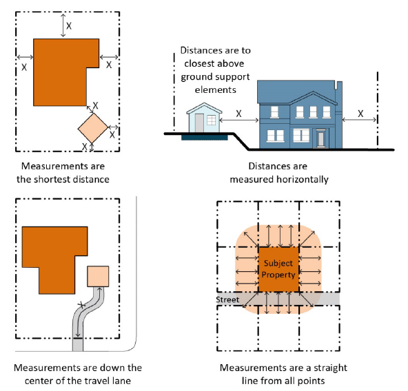
(Ord. 1627 § 4 (Exh. A), 2023; Ord. 1603 § 4 (Exh. I), 2023)
17.17.030 Measuring heights.
(A) Height Measurements. Height shall be measured as the vertical distance from finished grade at all points adjacent to the structure exterior to the highest point of the structure directly above (see Figure 17.17.030-1 (Measuring Heights)). For properties on a slope, the height of a structure shall be measured as the vertical distance from the average elevation of the finished grade to the highest point of the structure. The average elevation is determined by averaging the highest and lowest elevation points of the structure (see Figure 17.17.030-1 (Measuring Heights)).
Figure 17.17.030-1. Measuring Heights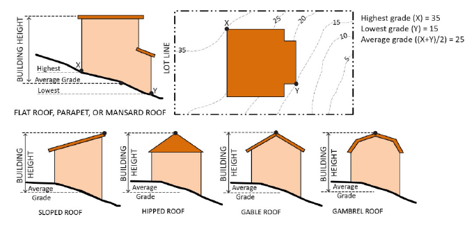
(B) Height of Structures. The height of each structure shall not exceed the height limit established for the applicable zone except as otherwise provided by this Section. Additional height limits are established for PMC § 17.82.020 (Accessory structures), PMC § 17.86.030 (Outdoor lighting), PMC § 17.86.040 (Walls and fences), PMC Chapter 17.88 (Signs), and PMC § 17.95.010 (Communication/wireless telecommunications facilities).
(C) Height of Structure Exceptions. The overall structure height shall not exceed the maximum height standard of the zone, except that the following architectural features may project above the maximum height by five feet or as established by zone, by Review Authority approval, or as otherwise allowed by this code:
(1) Architectural features, including skylights, chimneys, steeples, spires, towers, cupolas, and similar unoccupied features as approved by the Director;
(2) Elevators and stairways;
(3) Solar roof panels and appurtenant equipment;
(4) Antennas allowed without a discretionary permit, as identified by the FCC;
(5) Other mechanical equipment usually required to be placed above the roof level and not intended for human occupancy or to be used for any commercial or advertising purpose (e.g., water tanks, air conditioning units); and
(6) Flagpoles and sculptures; provided, that the same may be safely erected and maintained at such a height with respect to the surrounding conditions and circumstances.
(D) Measuring the Number of Stories. In measuring the number of stories in a structure, the following rules shall apply:
(1) An interior balcony or mezzanine shall be counted as a full story if its floor area exceeds one-half of the total area of the nearest full floor directly below it.
(2) Subterranean stories do not count towards maximum number of stories except as noted. A subterranean story shall be counted as a story for the purposes of height measurement where any portion of a subterranean story has more than one-half of its height above grade.
(3) A story shall not exceed 25 feet in height from the upper surface of the floor to the ceiling above.
(E) Fence and Wall Height Measurement.
(1) Fence and wall height shall be measured as the vertical distance from the average ground level immediately adjacent to the fence or wall to the top edge of the fence, wall, or other screening device.
(2) When there is a difference in the ground level between two adjoining parcels, the height of any wall or fence constructed along any property line shall be determined by using the level parcel line of the highest contiguous parcel. See Figure 17.17.030-2 (Measurement of Fence and Wall Height on Parcels with Different Elevations).
(3) An earthen berm or mound not taller than two feet may count toward required height of landscaping and screening.
Figure 17.17.030-2. Measurement of Fence and Wall Height on Parcels with Different Elevations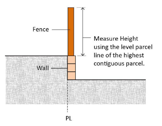
(F) Measuring the Height of Decks. Deck height is determined by measuring from the ground to the top of the floor of the deck directly above the ground below. (Ord. 1603 § 4 (Exh. I), 2023)
17.17.040 Lots and setbacks.
(A) Lot Width. Lot width is the horizontal distance between the side lot lines, measured at right angles to the lot depth at a point midway between the front and rear lot lines.
(B) Lot Depth. Lot depth is the horizontal length of a straight line measured down from the midpoint of the front property line of the lot to the midpoint of the rear property line or to the most distant point on any other lot line where there is no rear lot line, exclusive of any landscape easement.
Figure 17.17.040-1. Measuring Lot Width and Depth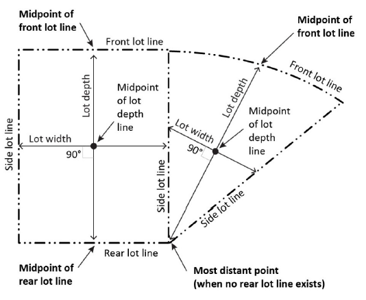
(C) Setbacks and Yards. The calculations of measurements related to setbacks and yards are defined in PMC Chapter 17.16 (Definitions). (Ord. 1603 § 4 (Exh. I), 2023)
17.17.050 Floor area and lot coverage.
(A) Determining Floor Area. The floor area of a structure is the sum of the gross horizontal areas of all floors of a structure or other enclosed structures, measured from the outside perimeter of the interior walls.
(1) Included in Floor Area. Floor area includes, but is not limited to, all habitable space (as defined in the California Building Code) that is below the roof and within the outer surface of the main walls of principal or accessory buildings. In the case of a multi-story structure that has covered or enclosed stairways, stairwells, or elevator shafts, the horizontal area of such features shall be counted only once at the floor level of their greatest area of horizontal extent.
(2) Excluded from Floor Area. Floor area does not include mechanical, electrical, and communication equipment rooms that do not exceed two percent of the structure’s gross floor area; bay windows or other architectural projections where the vertical distance between the lowest surface of the projection and the finished floor is 30 inches or greater; areas that qualify as usable open space including but not limited to balconies and outdoor terraces; and subterranean floors submerged more than four feet below finished grade of the property. Also excluded are areas used for all off-street parking spaces or loading spaces, driveways, ramps between floors of a multi-level parking garage, and maneuvering aisles.
(3) Nonresidential Uses. For nonresidential uses, gross floor area includes pedestrian access interior walkways or corridors, interior courtyards, walkways, paseos, or corridors covered by a roof or skylight. Nonresidential gross floor area does not include arcades, porticoes, and similar open areas that are located at or near street level and are accessible to the public but are not designed or used as sales, display, storage, service, or production areas.
(B) Determining Floor Area Ratio. The floor area ratio (FAR) is the ratio of the floor area, excluding unenclosed and unroofed areas as described in Subsection (C) of this Section (Determining Lot Coverage), of all primary and accessory buildings to the site area. To calculate the FAR, gross floor area is divided by site area, and typically expressed as a decimal. For example, if the floor area of all buildings on a site totals 20,000 square feet, and the site area is 10,000 square feet, the FAR is expressed as 2.0. Excludes below-grade floor area.
Figure 17.17.050-1. FAR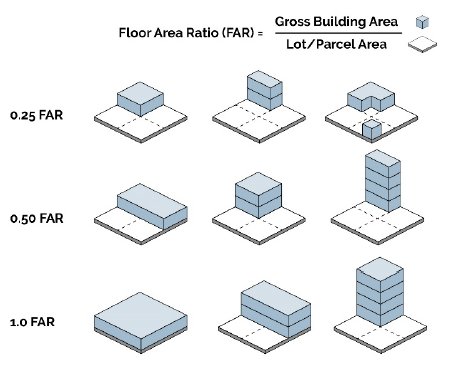
(C) Determining Lot Coverage. Lot coverage is the ratio of the total footprint area of all structures on a lot to the net lot area, typically expressed as a percentage. The footprints of all principal and accessory structures, including garages, carports, covered patios, and roofed porches, shall be summed to calculate lot coverage. The following structures shall be excluded from the calculation:
(1) Unenclosed and unroofed decks, patio slabs, porches, landings, and stairways less than four feet in height;
(2) Eaves and roof overhangs projecting up to three feet from a wall;
(3) Trellises, pergolas, and similar structures that have roofs that are at least 50 percent open to the sky through uniformly distributed openings and that are less than 400 square feet in size; and
(4) Swimming pools and hot tubs that are not enclosed in roofed structures or decks.
Figure 17.17.050-2. Determining Lot Coverage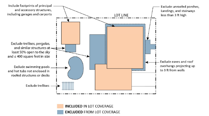
(Ord. 1603 § 4 (Exh. I), 2023)
17.17.060 Density.
Density shall be calculated as the number of units per net acre of a given land area (project area, subdivision, parcel). In mixed-use projects, density is the number of housing units divided by the land area of the mixed-use development (that includes areas used for nonresidential uses such as retail space). (Ord. 1603 § 4 (Exh. I), 2023)