


Chapter 14.43
– Land Divisions and Property Line Adjustments
Sections:
14.43.110 General Requirements
14.43.115 Flexible Lot Size; Flag Lots; Lots Accessed by Mid-Block Lanes
14.43.130 Preliminary Plat Submission Requirements
14.43.140 Approval Criteria: Preliminary Plat
14.43.150 Variances Authorized
14.43.160 Final Plat Submission Requirements and Approval Criteria
14.43.180 Performance Guarantee
14.43.190 Filing and Recording
14.43.200 Re-platting and Vacation of Plats
14.43.210 Property Line Adjustments
14.43.100 Purpose
The purpose of this chapter is to:
A. Provide rules, regulations and standards governing the approval of subdivisions, partitions and lot line adjustments, as defined below and in Chapter 14.13:
1. Subdivisions are the creation of four or more lots from one parent lot, parcel or tract, within one calendar year.
2. Partitions are the creation of three or fewer lots within one calendar year.
3. Lot line adjustments are modifications to lot lines or parcel boundaries that do not result in the creation of new lots (includes consolidation of lots).
B. Carry out the City’s development pattern, as envisioned by the Comprehensive Plan.
C. Encourage efficient use of land resources, full utilization of urban services, and transportation options;
D. Promote the public health, safety and general welfare through orderly and efficient urbanization;
E. Provide adequate light and air, prevent overcrowding of land, and provide for adequate transportation, water supply, sewage, fire protection, pollution control, surface water management, protection against natural hazards and other public services and facilities; and
F. Encourage the conservation of energy resources. (Ord. 2959 §5(Exh. A (part)), 2007. Formerly 4.3.100)
14.43.110 General Requirements
A. Subdivision and Partition Approval through Two-step Process. Applications for subdivision or partition approval shall be processed by means of a preliminary plat evaluation and a final plat evaluation, according to the following two steps:
1. The preliminary plat must be approved before the final plat can be submitted for approval consideration; and
2. The final plat must include all conditions of approval of the preliminary plat.
B. Compliance with ORS Chapter 92. All subdivision and partition proposals shall conform to state regulations in Oregon Revised Statute (ORS) Chapter 92, Subdivisions and Partitions, and Chapter 209, County Surveyors.
C. Future Re-division Plan. When subdividing or partitioning tracts into large lots (i.e., greater than two times or 200 percent the minimum lot size allowed by the underlying land use district), the City shall require that the lots be of such size, shape, and orientation as to facilitate future re-division in accordance with the requirements of the land use district and this Code. A re-division plan shall be submitted for large lots identifying:
1. Potential future lot division(s), consistent with the density and lot size standards of Chapter 2;
2. Potential street right-of-way alignments to serve future development of the property and connect to adjacent properties, including existing or planned rights-of-way;
3. A disclaimer that the plan is a conceptual plan intended to show potential future development. It shall not be binding on the City or property owners, except as may be required through conditions of land division approval. For example, dedication and improvement of rights-of-way within the future plan area may be required to provide needed secondary access and circulation.
D. Lot Size Averaging. Single-family residential lot size may be averaged to allow lots less than the minimum lot size in Residential districts, as provided by Section 14.43.115 Flexible Lot Size, 14.22.120 Development Standards, and 14.22.150 Residential Density Standard, or through approval of a Master Planned Development under Chapter 14.45.
E. Temporary Sales Office. A temporary sales office in conjunction with a subdivision may be approved as set forth in Section 14.49.100, Temporary Uses.
F. Minimize Flood Damage. All subdivisions and partitions shall be designed based on the need to minimize the risk of flood damage. No new building lots shall be created entirely within a floodway. All new lots shall be buildable without requiring development within the floodway (i.e. minimum lot size under base zoning must be provided outside of the floodway) and, where possible, allow building outside of the 100-year flood plain. Development in a 100-year flood plain shall comply with the National Flood Insurance Program and state building code requirements, including elevating structures above the base flood elevation. The applicant shall be responsible for obtaining floodplain development permit from the City of Cottage Grove.
G. Determination of Base Flood Elevation. Where a development site is located in or near areas prone to inundation for which the base flood elevation has not been mapped, the applicant shall have the base flood elevation it shall be determined by a qualified professional as part of the land division application.
H. Need for Adequate Utilities. All lots created through land division shall have adequate public utilities and facilities such as sewer, gas, electrical, and water systems. These systems shall be located and constructed to prevent or minimize flood damage, and to avoid impairment of the system and contamination from them during flooding.
I. Need for Adequate Drainage. All subdivision and partition proposals shall have adequate surface water drainage facilities that reduce exposure to flood damage and improve water quality. Water quality or quantity control improvements may be required. (Ord. 2959 §5(Exh. A (part)), 2007. Formerly 4.3.110)
14.43.115 Flexible Lot Size; Flag Lots; Lots Accessed by Mid-Block Lanes
A. Flexible Lot Size. To allow creativity and flexibility in subdivision design and to address physical constraints, such as topography, existing development, significant trees and other natural and built features, the approval body may grant a 10% modification to the lot area and/or lot dimension (width/depth) standards in Section 14.22.130, provided that the overall density of the subdivision does not exceed the allowable density of the district and the approval body finds that granting the modification allows for a greater variety of housing types or it improves development compatibility with natural features or adjacent land uses. The approval body may require that standard size lots be placed at the perimeter of the development where the abutting lots are standard size or larger; except that this provision shall not apply where the abutting lots are larger than 20,000 square feet.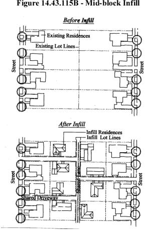
B. Mid-block lanes. Lots may be developed without frontage onto a public street when lot access is provided by mid-block lanes, as shown below. Mid-block lanes or shared driveways, as illustrated in Figure 14.43.115B, may be required, when practicable, to provide connectivity between infill developments. Mid-block lanes with access easements for adjoining properties may be allowed as an alternative to requiring through streets where block lengths do not necessitate a through street. The lanes shall meet the standards for Fire Department Access, and the standards under subsections C-F, below.
C. Flag lots. Flag lots may be created only when a through street or midblock lanes cannot be extended to serve abutting uses or future development. A flag lot driveway (“flag pole”) may serve no more than two dwelling units, including accessory dwellings and dwellings on individual lots, unless Uniform Fire Code (UFC) standards are met for more units. A drive serving more than one lot shall have a reciprocal access and maintenance easement recorded for all lots. No fence, structure or other obstacle shall be placed within the drive area. The fire marshal may require an emergency turnaround or fire hydrants. Fire sprinklers may also be required for buildings that cannot be fully served by fire hydrants (i.e., due to distance from hydrant or insufficient fire flow).
D. Driveway and lane width. The minimum paved width of all shared drives and mid-block lanes shall be 12 feet with an easement of 20 feet; easements must be 25 feet in width with a minimum paved width of 16 feet for all shared drives and/or mid-block lanes providing primary access to more than 2 dwelling units. The maximum width is 20 feet, except as required by the Uniform Fire Code. Alleys that provide secondary or maintenance access to lots which front on a through street or mid-block lane may be 16 to 20 feet in width, with a paved surface of 12 to 16 feet.
E. Easement and improvement of drive lane. The property owner shall record a 20-25 -foot easement benefiting all properties that are to receive vehicle access. The drive lane shall be improved with an all weather surface approved by the City. The easement shall state that the entire width of the easement shall remain unobstructed for emergency access. Dedication or recording, as applicable, shall be so indicated on the face of the subdivision or partition plat.
F. Maximum drive lane length. The maximum drive lane length is subject to requirements of the Uniform Fire Code, but shall not exceed 150 feet for a shared side drive, and 400 feet for a shared mid-block lane.
G. Future street plans. Building placement and alignment of shared drives shall be designed so that future street connections can be made as surrounding properties develop (i.e., as shown in the Figure 14.43.115.B). (Ord. 3136 §10, 2021; Ord. 2959 §5(Exh. A (part)), 2007. Formerly 4.3.115)
14.43.120 Preliminary Plat Approval Process
A. Review of Preliminary Plat. Review of a preliminary plat with 2 or 3 lots (partition) shall be processed with a Type II procedure, under Section 14.41.300. Preliminary plats with 4 or more lots (subdivision) shall be processed with a Type III procedure under Section 14.41.400. All preliminary plats shall be reviewed using approval criteria in Section 14.43.140. An application for subdivision may be reviewed concurrently with an application for a Master Planned Development under Chapter 14.45.
B. Review of Final Plat. Review of a final plat for a subdivision or partition shall be processed as a Type I procedure under Section 14.41.200, using the approval criteria in Section 14.43.160.
C. Preliminary Plat Approval Period. Preliminary plat approval shall be effective for a period of three (3) years from the date of approval. The preliminary plat shall lapse if a final plat has not been submitted within the 3-year period.
D. Modifications and Extensions. The applicant may request changes to the approved preliminary plat or conditions of approval following the procedures and criteria provided in Chapter 14.46 - Modifications. The Community Development Director shall, upon written request by the applicant and payment of the required fee, grant one written extension of the approval period not to exceed one year; provided that:
1. Any changes to the preliminary plat follow the procedures in Chapter 14.46;
2. The applicant has submitted written intent to file a final plat within the one-year extension period;
3. An extension of time will not prevent the lawful development of abutting properties;
4. There have been no changes to the applicable Code provisions on which the approval was based. If such changes have occurred, a new preliminary plat application shall be required; and
5. The extension request is made before expiration of the original approved plan.
E. Phased Development.
1. The City may approve a time schedule for developing a subdivision in phases, but in no case shall the actual construction time period for each phase (i.e., for required public improvements, utilities, streets) for any partition or subdivision phase be more than 3 years without reapplying for a preliminary plat;
2. The criteria for approving a phased land division proposal are:
a. Public facilities shall be constructed in conjunction with or prior to each phase;
b. The development and occupancy of any phase dependent on the use of temporary public facilities shall require Planning Commission approval. Temporary facilities shall be approved only upon City receipt of bonding or other assurances to cover the cost of required permanent public improvements, in accordance with Section 14.43.180. A temporary public facility is any facility not constructed to the applicable City or district standard;
c. The phased development shall not result in requiring the City or a third party (e.g., owners of lots) to construct public facilities that were required as part of the approved development proposal; and
d. The proposed time schedule for phased development approval shall be reviewed concurrently with the preliminary plat application, and the decision may be appealed in the same manner as the preliminary plat. (Ord. 2959 §5(Exh. A (part)), 2007. Formerly 4.3.120)
14.43.130 Preliminary Plat Submission Requirements
A. General Submission Requirements. For all partitions (three or fewer parcels), the application shall contain all of the information required for a Type II procedure under Section 14.41.300. For all subdivisions (four or more lots) the application shall contain all of the information required for a Type III procedure under Section 14.41.400, and the information in subsections 1-3, below:
1. Public Facilities and Services Impact Study, if required by the City and/or service provider. The impact study shall quantify and assess the effect of the development on public facilities and services. The City shall advise as to the scope of the study during the required pre-application conference (Section 14.41.600.C). The study may address the transportation system, including pedestrian ways and bikeways, the drainage system, the parks system, the water system, and the sewer system. For each public facility system and type of impact, the study shall propose improvements necessary to meet City standards and to minimize the impact of the development on the public at large, public facilities systems, and affected private property users;
2. Traffic Impact Study, if required by the City and/or road authority. Traffic Impact Studies shall conform to the standards and procedures in Section 14.41.900; and
3. In situations where this Code requires the dedication of real property to the City, the City shall either (1) include in the written decision evidence that shows that the required property dedication is directly related to and roughly proportional to the projected impacts of the development on public facilities and services, or (2) delete the dedication as a condition of approval.
B. Preliminary Plat Information. In addition to the general information described in Subsection A above, the preliminary plat application shall consist of drawings and supplementary written material (i.e., on forms and/or in a written narrative) adequate to provide the following information:
1. General information:
a. Name of subdivision (not required for partitions). This name must not duplicate the name of another subdivision in Lane County (please check with County Surveyor);
b. Date, north arrow, and scale of drawing;
c. Location of the development sufficient to define its location in the City, boundaries, and a legal description of the site;
d. A title block including the names, addresses and telephone numbers of the owners of the subject property and, as applicable, the designer, and engineer and surveyor if any, and the date of the survey if submitted; and
e. Identification of the drawing as a “preliminary plat”.
2. Site analysis:
a. Streets: Location, name, present width of all streets, alleys and rights-of-way on and abutting the site;
b. Easements: Width, location and purpose of all existing easements of record on and abutting the site;
c. Utilities: Location and identity of all utilities on and abutting the site. If water mains and sewers are not on or abutting the site, indicate the direction and distance to the nearest one and show how utilities will be brought to standards;
d. Ground elevations shown by contour lines at 5-foot vertical intervals for ground slopes exceeding 10 percent and at 2-foot intervals for ground slopes of less than 10 percent or as required by the City. Such ground elevations shall be related to some established benchmark or other datum approved by the County Surveyor or City Engineer. This requirement may be waived for partitions when grades, on average, are less than 6 percent;
e. The location and elevation of the closest benchmark(s) within or adjacent to the site (i.e., for surveying purposes);
f. Potential natural hazard areas, including any flood plains, areas subject to high water table, landslide areas, and areas having high erosion potential;
g. Sensitive lands, including wetland areas, streams, wildlife habitat, and other areas identified by the City or natural resource regulatory agencies as requiring protection. (See also, Chapter 14.37 and relevant portions of the Comprehensive Plan.);
h. Site features, including existing structures, pavement, large rock outcroppings, areas having unique views, and drainage ways, canals and ditches;
i. Designated historic and cultural resources on the site and adjacent parcels or lots;
j. The location, size and species of trees having a caliper (diameter) of 6 inches or greater at 4 feet above grade in conformance with Chapter 14.32;
k. North arrow and scale;
l. Date(s) prepared and revised;
m. Name and address of project designer, if applicable; and
n. Other information, as deemed appropriate by the Community Development Director. The City may require studies or exhibits prepared by qualified professionals to address specific site features and code requirements.
3. Proposed improvements:
a. Public and private streets, tracts, driveways, open space and park land; location, names, right-of-way dimensions, approximate radius of street curves; and approximate finished street center line grades. All streets and tracts that are being held for private use and all reservations and restrictions relating to such private tracts shall be identified;
b. Easements: location, width and purpose of all proposed easements;
c. Lots and private tracts (e.g., private open space, common area, or street): approximate dimensions, area calculation (e.g., in square feet), and identification numbers for all proposed lots and tracts;
d. Proposed uses of the property, including all areas proposed to be dedicated to the public or reserved as open space for the purpose of surface water management, recreation, or other use; potential location of future buildings;
e. Proposed improvements, as required by Chapter 3 (Design Standards), and timing of improvements (e.g., in the case of streets, sidewalks, street trees, utilities, etc.);
f. Preliminary location of development showing those future buildings can meet siting and dimensional standards of the district.
g. The proposed source of domestic water;
h. The proposed method of sewage disposal;
i. Proposed method of surface water drainage and treatment if required;
j. The approximate location and identity of other utilities, including the locations of street lighting fixtures;
k. Proposed railroad crossing or modifications to an existing crossing, if any, and evidence of contact with the affected railroad and the Oregon Department of Transportation Rail Division regarding proposed railroad crossing(s);
l. Changes to navigable streams, or other watercourses. Status of public access to these areas shall be shown on the preliminary plat, as applicable;
m. Identification of the base flood elevation for development within a designated 100-year floodplain. Written evidence of initiation of a Federal Emergency Management Agency (FEMA) flood plain map amendment shall be required when development is proposed to modify a designated 100-year flood plain. FEMA approval of the amendment shall be a condition of City land use approval;
n. Evidence of contact with from the road authority for any development requiring access to its facility(ies); and
o. Evidence of written notice to the applicable natural resource regulatory agency(ies) for any development within or adjacent to jurisdictional wetlands and other sensitive lands, as identified in Chapter 14.37. (Ord. 2959 §5(Exh. A (part)), 2007. Formerly 4.3.130)
14.43.140 Approval Criteria: Preliminary Plat
A. General Approval Criteria. The City may approve, approve with conditions or deny a preliminary plat based on the following approval criteria:
1. The proposed preliminary plat complies with the applicable Development Code sections and all other applicable ordinances and regulations. At a minimum, the provisions of this Chapter, and the applicable chapters and sections of Chapter 2 (Land Use Districts) and Chapter 3 (Design Standards) shall apply. Where a variance is necessary to receive preliminary plat approval, the application shall also comply with the relevant sections of Chapter 5;
2. The proposed plat name is not already recorded for another subdivision, and satisfies the provisions of ORS Chapters 92 and 209;
3. The proposed streets, roads, sidewalks, bicycle lanes, pathways, utilities, and surface water management facilities are laid out so as to conform or transition to the plats of subdivisions and maps of major partitions already approved for adjoining property as to width, general direction and in all other respects. All proposed public improvements and dedications are identified on the preliminary plat;
4. All proposed private common areas and improvements (e.g., homeowner association property) are identified on the preliminary plat;
5. Evidence that any required State and federal permits have been obtained, or shall be obtained before approval of the final plat;
6. Evidence that improvements or conditions required by the City, road authority, Lane County, special districts, utilities, and/or other service providers, as applicable to the project, have been or can be met; and
7. If any part of the site is located within an Overlay Zone or previously approved Planned Unit Development, Mixed Use Master Plan or Master Planned Development, it shall conform to the applicable regulations and/or conditions.
B. Layout and Design of Streets, Blocks and Lots. All proposed blocks (i.e., one or more lots bound by public streets), lots and parcels conform to the specific requirements below:
1. All lots shall comply with the lot area, setback, and dimensional requirements of the applicable land use district (Chapter 2), and the standards of Section 14.31.200.J - Street Connectivity and Formation of Blocks.
2. Setbacks shall be as required by the applicable land use district (Chapter 2).
3. Each lot shall conform to the standards of Chapter 14.31 - Access and Circulation.
4. Landscape or other screening may be required to maintain privacy for abutting uses. See Chapter 2 - Land Use Districts, and Chapter 14.32 - Landscaping.
5. In conformance with the Uniform Fire Code, a fire apparatus access drive shall be provided to serve all portions of a building that are located more than 150 feet from a public right-of-way or approved access drive. This drive shall have a minimum paved surface of 12 feet (for one to two dwelling units) or minimum16 feet (three to four dwelling units), with 20 feet minimum of clearance. See Chapter 14.31- Access and Circulation and Section 14.43.115(D).
6. Where a common drive is to be provided to serve more than one lot, a reciprocal easement which will ensure access and maintenance rights shall be recorded with the approved subdivision or partition plat.
7. All applicable engineering design standards for streets, utilities, surface water management, and easements shall be met.
C. Conditions of Approval. The City may attach such conditions as are necessary to carry out provisions of this Code, and other applicable ordinances and regulations, and may require reserve strips be granted to the City for the purpose of controlling access to adjoining undeveloped properties. See Chapter 14.34 (Public Facilities). (Ord. 2959 §5(Exh. A (part)), 2007. Formerly 4.3.140)
14.43.150 Variances Authorized
Variances to the standards of this Chapter shall be processed in accordance with Chapter 14.51 - Variances. Applications for variances shall be submitted at the same time an application for land division or lot line adjustment is submitted, and the applications shall be reviewed together. (Ord. 2959 §5(Exh. A (part)), 2007. Formerly 4.3.150)
14.43.160 Final Plat Submission Requirements and Approval Criteria
A. Submission Requirements. Final plats shall be reviewed and approved by the City prior to recording with Lane County. The applicant shall submit the final plat within 1 year of the approval of the preliminary plat as provided by Section 14.43.120. Specific information about the format and size of the plat, number of copies and other detailed information can be obtained from the Community Development Director.
B. Approval Criteria. By means of a Type I procedure, the Community Development Director and City Engineer shall review the final plat and shall approve or deny the final plat based on findings regarding compliance with the following criteria:
1. The final plat is consistent in design (e.g., number, area, dimensions of lots, easements, tracts, right-of-way) with the approved preliminary plat, and all conditions of approval have been satisfied;
2. All public improvements required by the preliminary plat have been installed and approved by the City Engineer or appropriate service provider (e.g., power, television, gas authority). Alternatively, the developer has provided a performance guarantee or completion bond in accordance with Section 14.43.180;
3. The streets and roads for public use are dedicated without reservation or restriction other than reversionary rights upon vacation of any such street or road and easements for public utilities;
4. The streets and roads held for private uses have been approved by the City as conforming to the preliminary plat;
5. The plat and deed contain a dedication to the public of all public improvements, including but not limited to streets, public pathways and trails, access reserve strips, parks, sewage disposal storm drainage and water supply systems;
6. The applicant has provided copies of all recorded homeowners association Covenants, Conditions and Restrictions (CC&R’s); deed restrictions; private easements and agreements (e.g., for access, common areas, parking, etc.); and other recorded documents pertaining to common improvements recorded and referenced on the plat;
7. The plat complies with the applicable Sections of this code (i.e., there have been no changes in land use or development resulting in a code violation since preliminary plat approval);
8. Certification by the City that water and sanitary sewer service is available to every lot depicted on the plat; or bond, contract or other assurance has been provided by the subdivider/partitioner to the City that such services will be installed in accordance with Chapter 14.34 - Public Facilities, and the bond requirements of Section 14.43.180. The amount of the bond, contract or other assurance by the subdivider/partitioner shall be determined by the bid amount, subject to review and approval by the City;
9. The plat contains an affidavit by the surveyor who surveyed the land, represented on the plat to the effect the land was correctly surveyed and marked with proper monuments as provided by ORS Chapters 92 and 209. (Ord. 2959 §5(Exh. A (part)), 2007. Formerly 4.3.160)
14.43.170 Public Improvements Required
Before City approval is certified on the final plat, all required public improvements shall be installed, inspected, and approved. Alternatively, the subdivider/partitioner shall provide a performance guarantee or completion bond, in accordance with Section 14.43.180. (Ord. 2959 §5(Exh. A (part)), 2007. Formerly 4.3.170)
14.43.180 Performance Guarantee
A. Performance Guarantee Required. When a performance guarantee is required under Section 14.43.170, the subdivider/partitioner shall file an assurance of performance with the City supported by one of the following:
1. An irrevocable letter of credit executed by a financial institution authorized to transact business in the state of Oregon;
2. A completion bond executed by a surety company authorized to transact business in the state of Oregon which remains in force until the surety company is notified by the City in writing that it may be terminated; or
3. Cash in an escrow account.
B. Determination of Sum. The assurance of performance shall be for a sum determined by the City as required to cover the cost of the improvements and repairs, including related engineering and incidental expenses.
C. Itemized Improvement Estimate. The developer shall furnish to the City an itemized improvement estimate, certified by a registered civil engineer, to assist the City in calculating the amount of the performance assurance.
D. Agreement. An agreement between the City and developer shall be recorded with the final plat. The agreement may be prepared by the City or prepared by the applicant as a letter. It shall not be valid until it is signed and dated by both the applicant and City Manager. The agreement shall include but not be limited to the following, as determined by the City Engineer:
1. The period within which all required improvements and repairs shall be completed;
2. A provision that if work is not completed within the period specified, the City may complete the work and recover the full cost and expenses from the applicant;
3. Required improvement fees and deposits;
4. (Optional) Provisions for the construction of the improvements in stages and for the extension of time under specific conditions therein stated in the contract.
E. When Subdivider Fails to Perform. In the event the developer fails to carry out all provisions of the agreement and the City has un reimbursed costs or expenses resulting from such failure, the City shall call on the bond, cash deposit or letter of credit for reimbursement.
F. Termination of Performance Guarantee. The developer shall not cause termination of nor allow expiration of the guarantee before the end of the one-year warranty period without having first secured written authorization from the City. (Ord. 2959 §5(Exh. A (part)), 2007. Formerly 4.3.180)
14.43.190 Filing and Recording
A. Filing Plat with County. Within 60 days of the City approval of the final plat, the applicant shall submit the final plat to Lane County for signatures of County officials as required by ORS Chapters 92 and 209.
B. Proof of Recording. Upon final recording with the County, the applicant shall submit to the City a mylar copy of all sheets of the recorded final plat. This shall occur prior to the issuance of building permits for the newly created lots.
C. Prerequisites to Recording the Plat.
1. No plat shall be recorded unless all ad valorem taxes and all special assessments, fees, or other charges required by law to be placed on the tax roll have been paid in the manner provided by ORS Chapters 92 and 209;
2. No plat shall be recorded until it is approved by the County Surveyor in the manner provided by ORS Chapters 92 and 209. (Ord. 2959 §5(Exh. A (part)), 2007. Formerly 4.3.190)
14.43.200 Re-platting and Vacation of Plats
A. Re-platting and Vacations. Any plat or portion thereof may be re-platted or vacated upon receiving an application signed by all of the owners as appearing on the deed.
B. Procedure. All applications for a re-plat or vacation shall be processed in accordance with the procedures and standards for a subdivision or partition (i.e., the same process used to create the plat shall be used to re-plat or vacate the plat). The same appeal rights provided through the subdivision and partition process shall be afforded to the plat vacation process. (See Chapter 14.41 - Types of Applications and Review Procedures.) The road authority(ies) shall be notified of all applications for re-plats and street vacations. All street vacations shall also conform to the ORS Chapter 271.
C. Basis for Denial. A re-plat or vacation application may be denied if it abridges or destroys any public right in any of its public uses, improvements, streets or alleys; or if it fails to meet any applicable criteria of this chapter.
D. Recording of Vacations. All approved plat vacations shall be recorded in accordance with 14.43.190 and the following procedures:
1. Once recorded, a re-plat or vacation shall operate to eliminate the force and effect of the plat prior to vacation; and
2. Vacations shall also divest all public rights in the streets, alleys and public grounds, and all dedications described on the plat.
E. After Sale of Lots. When lots have been sold, the plat may be vacated only in the manner herein, and provided that all of the owners of lots within the platted area consent in writing to the plat vacation.
F. Street Requirement. Except as prohibited by law (e.g., ORS 92.837, Manufactured Home Park), in approving a right-of-way vacation or re-plat, the City may require dedication of access ways, paths or trails as a condition of the vacation of any public easement or right-of-way, in order to establish or maintain a safe, convenient and direct pedestrian and bicycle circulation system. Such requirements shall be coordinated with the applicable road authority. (Ord. 2959 §5(Exh. A (part)), 2007. Formerly 4.3.200)
14.43.210 Property Line Adjustments
A Property Line Adjustment is the modification of lot boundaries, when no lot is created or removed. The application submission and approval process is as follows:
A. Submission Requirements. All applications for Property Line Adjustment shall be made on forms provided by the City and shall be governed by Section 14.41.300.D-H. The application shall include a preliminary lot line map drawn to scale identifying all existing and proposed lot lines and dimensions; footprints and dimensions of existing structures (including accessory structures); location and dimensions of driveways and public and private streets within or abutting the subject lots; existing fences and walls; and any other information deemed necessary by the Community Development Director or designee for ensuring compliance with City codes.
B. Approval Process.
1. Decision-making process. Property line adjustments shall be reviewed by means of a Type II procedure, as governed by Section 14.41.300.D-H, using approval criteria contained in Section 14.43.210.C below. The road authority(ies) shall be notified of lot line adjustments that may affect property access or traffic volumes or operations on their facilities.
2. Time limit on approval. The property line adjustment approval shall be effective for a period of one (1) year from the date of approval, during which time it must be recorded.
3. Lapsing of approval. The property line adjustment approval shall lapse if:
a. The property line adjustment is not recorded within the time limit in Section 14.43.210.B(2);
b. The property line adjustment has been improperly recorded with Lane County without the satisfactory completion of all conditions attached to the approval; or
c. The final recording is a departure from the approved plan.
C. Approval Criteria. The Community Development Director or designee shall approve or deny a request for a property line adjustment in writing based on all of the following criteria:
1. Parcel Creation. No additional parcel or lot is created or removed by the lot line adjustment;
2. Lot standards. All lots and parcels conform to the applicable lot standards of the land use district (Chapter 2) including lot area, dimensions, setbacks, and coverage, and no resulting lot is wholly comprised of a flood hazard area or jurisdictional wetland;
3. Access and Road authority Standards. All lots and parcels can conform to the standards or requirements of Chapter 14.31.200 – Vehicle Access and Circulation, and all applicable road authority requirements are met. If a lot is nonconforming to any City or road authority standard, it shall not be made even less conforming by the property line adjustment.
D. Recording Property Line Adjustments.
1. Recording. Upon the City’s approval of the proposed property line adjustment, the applicant shall record the property line adjustment with Lane County before the decision expires, and submit a copy of the recorded survey map to the City, to be filed with the approved application.
2. Time limit. The applicant shall submit a copy of the recorded property line adjustment survey map to the City prior to the issuance of any building permits on the re-configured lots.
E. Extension.
The City shall, upon written request by the applicant and payment of the required fee, grant a written extension of the approval period not to exceed one year provided that:
1. No changes are made to the original property line adjustment as approved by the City;
2. The applicant can show intent of recording the approved plan within the one-year extension period;
3. There have been no changes in the applicable Code or plan provisions on which the approval was based. In the case where the property line adjustment conflicts with a code change, the extension shall be denied; and
4. The extension request is made before expiration of the original approved plan. (Ord. 2959 §5(Exh. A (part)), 2007. Formerly 4.3.210)