


Chapter 16.10
ENVIRONMENTALLY CRITICAL AREAS
Sections:
16.10.030 Applicability--Regulated activities.
16.10.040 Procedural provisions.
16.10.060 Conforming and nonconforming structures.
16.10.070 Reasonable use provision.
16.10.080 Environmentally critical areas maps.
16.10.090 Surface water study areas.
16.10.100 Relationship to other regulations.
16.10.110 Proposed development.
16.10.120 Permit process and application requirements.
16.10.130 Classification and rating of environmentally critical areas.
16.10.150 Buffer width variances.
16.10.160 Alteration or development of environmentally critical areas--Standards and criteria.
16.10.170 General mitigation standards.
16.10.180 Other appropriate mitigation actions.
16.10.190 Mitigation standards, criteria and plan requirements.
16.10.200 Performance standards for mitigation planning.
16.10.210 Approved mitigation projects--Signature.
16.10.220 Approved mitigation projects--Contingency planning.
16.10.230 Mitigation monitoring and maintenance--General standards.
16.10.300 Classification and rating of wetlands.
16.10.320 Alteration of wetlands--Performance standards.
16.10.330 Wetland mitigation performance standards.
16.10.340 Wetland mitigation monitoring and maintenance.
16.10.400 Classification and rating of streams.
16.10.420 Alteration of streams and stream buffers.
16.10.430 Stream mitigation performance standards.
16.10.500 Classification and rating of fish and wildlife habitats.
16.10.510 Fish and wildlife habitat area buffers.
16.10.520 Alteration of fish and wildlife habitat areas.
16.10.530 Fish and wildlife habitat area mitigation performance standards.
16.10.540 Fish and wildlife habitat area mitigation monitoring and maintenance.
16.10.600 Classification and rating of geologic hazard areas.
16.10.620 Alteration of geologic hazard areas.
16.10.630 Geologic hazard area performance standards.
16.10.640 Geotechnical report--Required information.
16.10.650 Geologic hazard area mitigation monitoring and maintenance.
16.10.700 Classification and rating of aquifer recharge and wellhead protection areas.
16.10.710 Alteration of aquifer recharge and wellhead protection areas.
16.10.720 Aquifer recharge and wellhead protection area performance standards.
16.10.010 Purpose and intent.
A. The Town Council finds that the Town contains certain areas that can be identified and characterized as environmentally sensitive or critical. Such areas within the Town include wetlands, streams, fish and wildlife habitat, geologic hazards, aquifer recharge and wellhead protection areas, and associated environmentally critical area buffers.
B. The Town finds that unregulated development patterns may in some cases result in natural disasters that threaten public health and safety, and that by preventing development on certain environmentally critical areas, the Town can better maintain public health, safety, and welfare by avoiding natural disasters such as slides and flooding that threaten life and property. In addition, through the prevention of disturbances to environmentally critical areas and their buffers that may result in degradation, erosion, or damages to protective vegetation, and by preserving features that provide for clean water, fisheries habitat including near-shore habitat, and wildlife habitat, the Town can help maintain a positive ecological balance that provides for the immediate and long-term public welfare. This chapter is intended to preserve the Town’s important environmental features while allowing development to occur if compatible with and in consideration of these environmentally critical areas.
C. The classification and designation of these environmentally critical areas are intended to ensure the conservation and protection of environmentally critical areas from loss or degradation, and to restrict land uses and development that are incompatible with environmentally critical areas. It is the intent of this chapter to designate and protect environmentally critical areas.
D. The Town finds that these essential environmentally critical areas perform a variety of valuable and beneficial biological and physical functions that benefit the Town and its residents. The Town further finds that the functions of environmentally critical areas include the following:
1. Wetland Areas. Wetlands and their associated buffers help to maintain water quality; store and convey stormwater and floodwater; recharge groundwater; provide important fish and wildlife habitat; and provide valuable functions for recreation, education, scientific study, and aesthetic appreciation. Wetland buffers serve to moderate runoff volume and flow rates; reduce sediment, chemical nutrient and toxic pollutants; provide shading to maintain desirable water temperatures; provide habitat for fish and wildlife; protect wetland resources from harmful intrusion; and generally preserve the ecological integrity of the wetland area.
2. Stream Areas. Streams and their associated buffers provide important fish and wildlife habitat and corridors; help to maintain water quality; store and convey stormwater and floodwater; recharge groundwater; and serve a valuable function for recreation, education, scientific study, and aesthetic appreciation.
3. Fish and Wildlife Habitat Areas. Identification, preservation and protection of fish and wildlife habitat areas provide opportunities for food, cover, nesting, breeding, and movement for fish and wildlife within the Town; maintain and promote diversity of species and habitat within the Town; coordinate habitat protection with elements of the Town’s established open space corridors wherever possible; help to maintain air and water quality; control erosion; serve a valuable function for recreation, education, scientific study, and aesthetic appreciation; and contribute to the established character of the Town.
4. Geologic Hazard Areas. Geologic hazard areas include lands that are affected by natural processes that make them susceptible to landslides, seismic activity, and severe erosion, especially bluff and ravine areas.
5. Aquifer Recharge and Wellhead Protection Areas. Aquifer recharge and wellhead protection areas provide a source of potable water and contribute to stream discharge during periods of low water flow. Aquifer recharge and wellhead protection areas have been identified that are susceptible to contamination through potential infiltration of pollutants through the soil to groundwater. The primary purpose of aquifer recharge and wellhead protection area regulations is to protect critical aquifer recharge and wellhead protection areas by avoiding land use activities that pose the potential for aquifer contamination; and to minimize impacts to significant recharge areas and to surface water habitat that is dependent on groundwater recharge through the application of strict performance standards.
E. This chapter contains standards, guidelines, criteria, and requirements intended to identify, analyze, preserve, and mitigate potential impacts to the Town’s environmentally critical areas and to enhance and restore degraded resources, such as wetlands, streams and fish and wildlife habitat, where possible. The standards, guidelines, and criteria have been established using "best available science." The intent of these regulations is to avoid impacts to environmentally critical areas. In appropriate circumstances, impacts to specified environmentally critical areas resulting from regulated activities may be minimized, rectified, reduced, and/or compensated for, consistent with the requirements of this chapter and best available science.
F. It is the further intent of this chapter to:
1. Provide standards, guidelines, and criteria to guide application of these environmentally critical areas goals and policies when considered with other goals and policies of the Woodway Municipal Code and comprehensive plan including those pertaining to natural features and environmental protection;
2. Serve as a basis for exercise of the Town’s substantive authority under the State Environmental Policy Act (SEPA) and the Town’s SEPA rules (Chapter 16.04 of this code);
3. Comply with the requirements of the Growth Management Act (Chapter 36.70A RCW) and implementing rules; and
4. Coordinate environmental review and permitting of proposals to avoid duplication and delay. (Ord. 20-611 § 3 (Exh. C (part)), 2020)
16.10.020 Definitions.
For purposes of this chapter, the following definitions shall apply:
"Alteration" means any human-induced change in an existing condition of an environmentally critical area or its buffer. Alterations include but are not limited to grading, filling, channelizing, dredging, clearing (vegetation), draining, construction, compaction, excavation, or any other activity that changes the character of the environmentally critical area or its buffer.
"Applicant" means the person, party, firm, corporation, or other entity that proposes any activity that could affect a wetland, stream, fish and wildlife habitat, or other critical area.
"Aquifer" means a geologic formation, group of formations, or part of a formation capable of yielding a significant amount of groundwater to wells or springs (Chapter 173-160 WAC).
"Aquifer recharge area" means areas designated by WAC 365-190-080(2) that are determined to have a critical recharging effect on aquifers (i.e., maintain the quality and quantity of water) used for potable water as defined by WAC 365-190-030(2).
"Aquifer susceptibility" means the ease with which contaminants can move from the land surface to the aquifer based solely on the types of surface and subsurface materials in the area. Susceptibility usually defines the rate at which a contaminant will reach an aquifer unimpeded by chemical interactions with the vadose zone media.
"Aquifer vulnerability" is the combined effect of susceptibility to contamination and the presence of potential contaminants.
"Artificially created wetland" means wetlands created through purposeful human action from non-wetland sites, such as irrigation and drainage, grass-lined swales, canals, detention facilities, wastewater treatment facilities, farm ponds, and landscape amenities.
"Best available science," in the context of environmentally critical areas protection, means a valid scientific process that produces reliable information useful in understanding the consequences of a local government’s regulatory decisions consistent with the criteria in WAC 365-195-905.
"Best management practices" means conservation practices or systems of practices and management measures that:
1. Control soil loss and reduce water quality degradation caused by nutrients, animal waste, toxins, and sediment;
2. Minimize adverse impacts to surface water and groundwater flow, circulation patterns, and to the chemical, physical, and biological characteristics of waters, wetlands, and other fish and wildlife habitat;
3. Control site runoff, spillage, leaks, sludge, or water disposal, or drainage from raw material.
"Buffer (buffer zone)" means the area adjacent to the outer boundaries of critical areas including wetlands, habitat conservation areas such as streams and marine shorelines, and/or landslide hazard areas that separates and protects critical areas from adverse impacts associated with adjacent land uses.
"Clearing" means the removal of timber, brush, grass, groundcover, or other vegetative matter from a site that exposes the earth’s surface of the site.
"Creation" means the producing or forming of a wetland or stream through artificial means from an upland (dry) site.
"Critical habitat" or "critical fish and wildlife habitat" means habitat areas associated with threatened, endangered, or environmentally critical species of plants, fish, or wildlife and which, if altered, could reduce the likelihood that the species will maintain and reproduce over the long term. Such areas are documented with reference to lists, categories, and definitions of species promulgated by the Washington Department of Fish and Wildlife (nongame data system special animal species) as identified in WAC 232-12-011 or 232-12-014 and in the priority habitat species lists compiled in compliance with WAC 365-190-080; or by rules and regulations adopted currently or hereafter by the U.S. Fish and Wildlife Service. Critical habitat also includes the following types of areas:
1. Regionally rare native fish and fish and wildlife habitat (i.e., one of five or fewer examples of the habitat type within the county);
2. Category I wetlands as defined in these regulations;
3. Documented commercial and/or recreational shellfish beds managed by the Washington Department of Fisheries;
4. Class I streams as defined in these regulations;
5. State nature area preserves or natural resource conservation areas identified by state law and managed by the Department of Natural Resources; and
6. Naturally occurring ponds stocked with game fish by government or tribal entities; and naturally occurring ponds of greater than one acre and less than twenty acres in area with cover of submerged aquatic vegetation, shrubs, or trees not exceeding fifty percent of the area of surface water, and whose maximum depth does not exceed 6.6 feet.
Critical habitat does not include artificially created habitat and/or habitat created by purposeful human action, including but not limited to landscape amenities, detention facilities, grass-lined swales, and open space areas.
"Department" means the Town Department of Planning.
"Development" means any activity that requires federal, state, or local approval for the use or modification of land or its resources. These activities include, but are not limited to: subdivisions and short subdivisions; binding site plans; planned unit developments; variances; shoreline substantial development; clearing activity; fill and grade work; activity conditionally allowed; building or construction; tree removal; revocable encroachment permits; and septic approval.
"Director" means the Public Works Director, or his or her designee.
"Earth" or "earth material" means naturally occurring rock, soil, stone, sediment, or a combination thereof.
"Emergency activities" are those activities that require immediate action within a time too short to allow full compliance with this chapter due to an unanticipated and imminent threat to public health, safety, or the environment. Emergency construction does not include development of new permanent protective structures where none previously existed. All emergency construction shall be consistent with the policies of Chapter 90.58 RCW and this chapter. As a general matter, flooding or other seasonal events that can be anticipated and may occur but that are not imminent are not an emergency.
"Enhancement" means:
1. For wetlands, the improvement of an existing viable wetland or buffer, such as by increasing plant diversity, increasing fish and wildlife habitat, installing environmentally compatible erosion controls, or removing nonindigenous plant or animal species; or
2. For streams and fish and wildlife habitat, the improvement of an existing habitat or an existing stream or associated buffer such as by modifying the channel or substrate, increasing riparian plant density or structural diversity, installing environmentally compatible erosion controls, or removing nonindigenous plant or animal species.
"Erosion" means the wearing away of the earth’s surface as a result of the movement of wind, water, or ice.
"Excavation" means the mechanical removal of earth material.
"Exotic" means any species of plant or animal that is foreign (i.e., not native to the Puget Sound area).
"Fill" or "fill material" means a deposit of earth material placed by human or mechanical (machine) means.
"Filling" means the act of transporting or placing (by any manner or mechanism) fill materials from, to, or on any soil surface, sediment surface, or other fill materials.
"Fish and wildlife habitat areas" are areas important for maintaining species in suitable habitats within their natural geographic distribution so that isolated populations are not created.
"Fish and wildlife report" means a report prepared by a qualified consultant who evaluated plant communities and fish and wildlife functions and values on a site, consistent with the format and requirements established by this chapter.
"Geologically hazardous areas" means areas that, because of their susceptibility to erosion, sliding, earthquake, or other geological events, pose unacceptable risks to public health and safety and may not be suited to commercial, residential, or industrial development.
"Grading" means any excavating, filling, clearing, leveling, or contouring of the ground surface by human or mechanical means.
"Groundwater" means all water that exists beneath the land surface or beneath the bed of any stream, lake, reservoir, or other body of surface water within the boundaries of the state, whatever may be the geological formation or structure in which such water stands or flows, percolates, or otherwise moves (Chapter 90.44 RCW).
"Habitat" or "fish and wildlife habitat" means areas that provide food, protective cover, nesting, breeding, or movement for fish and wildlife.
"Habitat buffer" means an area surrounding a defined fish and wildlife habitat or wetland that reduces adverse impacts to habitat/wetland functions from adjacent development or other activities or uses; the area between a fish and wildlife habitat or wetland and the upland that serves as a transition zone.
"Habitat management" means management of land to maintain species in suitable habitats within their natural geographic distribution so that isolated subpopulations are not created.
"Habitat map" means maps of plant cover types/communities used to indicate the potential presence of fish and wildlife species.
"Hydraulic project approval" (HPA) means a permit issued by the State Department of Fish and Wildlife for modifications to waters of the state in accordance with Chapter 75.20 RCW.
"Hydric soil" means a soil that is saturated, flooded, or ponded long enough during the growing season to develop anaerobic conditions in the upper part. The presence of hydric soil shall be determined following the methods described in the Washington State Wetland Identification and Delineation Manual (RCW 36.70A.175).
"Hydrophytic vegetation" means macrophytic plant life growing in water or on a substrate that is at least periodically deficient in oxygen as a result of excessive water content.
"Impervious surface" means a hard surface area that either prevents or retards the entry of water into the soil mantle compared to natural conditions prior to development or that causes water to run off the surface in greater quantities or at an increased rate of flow compared to natural conditions prior to development. Common impervious surfaces may include, but are not limited to, rooftops, walkways, patios, driveways, parking lots, storage areas, concrete or asphalt paving, gravel roads, packed earthen materials, and oiled macadam or other surfaces which similarly impede the natural infiltration of stormwater. Impervious surfaces do not include surfaces created through proven low impact development techniques.
"Infiltration" means the downward entry of water into the immediate surface of soil.
"In-kind mitigation" means replacement of environmentally critical areas with substitute environmentally critical areas whose characteristics closely approximate those destroyed or degraded by a regulated activity.
"Intentionally created streams" means streams created through purposeful human action, such as irrigation and drainage ditches, grass-lined swales, and canals.
"Isolated wetland" means wetlands that are not hydrologically connected to other surface water features, either by aboveground flows or shallow subsurface water features.
"Lake" means a naturally or artificially created body of deep (generally greater than 6.6 feet) open water that persists throughout the year. A lake is larger than a pond, greater than one acre in size, equal to or greater than 6.6 feet in depth, and has less than thirty percent aerial coverage by trees, shrubs, or persistent emergent vegetation. A lake is bounded by the ordinary high water mark or the extension of the elevation of the lake’s ordinary high water mark with the stream where the stream enters the lake.
"Mitigation" means and includes:
1. Avoiding the impact altogether by not taking a certain action or parts of actions;
2. Minimizing impacts by limiting the degree or magnitude of the action and its implementation;
3. Rectifying the impact by repairing, rehabilitating, or restoring the affected environment;
4. Reducing or eliminating the impact over time by preservation and maintenance operations pursuant to activities undertaken during the life of the action;
5. Compensating for the impact by replacing or providing substitute resources or environments.
While monitoring without additional actions is not considered mitigation for the purposes of these regulations, it may be a part of a comprehensive mitigation program.
"Monitoring" means evaluating the impacts of development proposals over time on the biological, hydrological, pedological, and geological elements of such systems and/or assessing the performance of required mitigation measures through the collection and analysis of data by various methods for the purpose of understanding and documenting changes in natural ecosystems and features, and includes gathering baseline data.
"Native vegetation" means vegetation that is indigenous to the area in question.
"No net loss" means the maintenance of the aggregate total of the Town’s environmentally critical area functions and values as achieved through a case-by-case review of development proposals. Each project shall be evaluated based on its ability to meet the no net loss goal.
"Ordinary high water mark" means that mark that will be found by examining the bed and banks of a stream and ascertaining where the presence and action of waters are so common and usual, and so long maintained in ordinary years, as to mark upon the soil a vegetative character distinct from that of the abutting upland. In any area where the ordinary high water mark cannot be found, the line of mean high water shall substitute. In any area where neither can be found, the top of the channel bank shall be substituted.
"Out-of-kind mitigation" means replacement of environmentally critical areas with substitute environmentally critical areas whose characteristics do not closely approximate those destroyed or degraded by a regulated activity.
"Outside edge of the buffer" means the edge of the buffer that is the farthest distance from the critical area being protected by the buffer.
"Permanent erosion control" means continuous on-site and off-site control measures that are needed to control conveyance or deposition of earth, turbidity, or pollutants after development, construction, or restoration.
"Pond" means a naturally existing body of standing water, which exists on a year-round basis and occurs in a depression of land or expanded portion of a stream.
"Priority species" or "priority fish and wildlife species" means fish and wildlife species of concern due to their population status and sensitivity to habitat alteration, as identified by the Washington Department of Fish and Wildlife.
"Qualified professional consultant" means a professionally trained and/or certified fish and wildlife or stream biologist, ecologist, or other professional with expertise in the scientific disciplines necessary to identify, evaluate, and manage habitat and streams. This term also means a professionally licensed civil engineer with a practice as a geotechnical engineer or a licensed engineering geologist with expertise in the engineering and behavior of earth materials.
"Qualified wetland specialist" means a professionally trained and/or certified wetlands biologist or wetlands ecologist.
"Recharge" means the process involved in the absorption and addition of water from the unsaturated zone to groundwater.
"Regulated activity" means activities occurring in or near and/or potentially affecting environmentally critical areas or buffers that are subject to the provisions of this chapter. Regulated activities generally include but are not limited to any filling, dredging, dumping or stockpiling, draining, excavation, flooding, construction or reconstruction, driving pilings, obstructing, shading, clearing, or harvesting.
"Rehabilitation" means the establishment of a viable environmentally critical area from a previously filled or degraded environmentally critical area.
"Restoration" means the reestablishment of a viable environmentally critical area from a previously filled or degraded environmentally critical areas wetland site.
"Riparian corridor" or "riparian zone" means the area adjacent to a water body (stream, lake, or marine water) that contains vegetation that influences the aquatic ecosystem, near-shore area, and/or fish and wildlife habitat by providing shade, fine or large woody material, nutrients, organic debris, sediment filtration, and terrestrial insects (prey production). Riparian areas include those portions of terrestrial ecosystems that significantly influence exchanges of energy and matter with aquatic ecosystems (i.e., zone of influence). Riparian zones provide important wildlife habitat. They provide sites for foraging, breeding, and nesting; cover to escape predators or weather; and corridors that connect different parts of a watershed for dispersal and migration.
"Routine landscape maintenance" shall mean keeping a landscape healthy, clean, and safe using hand labor and light equipment to carry out plantings, periodic weeding and fertilizing, other gardening, lawn care, path maintenance, plant pruning, and other jobs for protecting and improving the topsoil, plants, and garden accessories that are undertaken by a person in connection with the normal maintenance and repair of property.
1. This definition does not include tree removal or topping.
2. This definition includes removal of the following vegetation:
a. Any species on the Washington State or Snohomish County Noxious Weed List;
b. English ivy (Hedera helix);
c. English laurel (Prunus laurocerasus) and other laurel species;
d. English holly (Ilex aquifolium);
e. Himalayan blackberry (Rubus armeniacus); and
f. Evergreen blackberry (Rubus laciniatus).
3. This definition does not include work associated with a larger common plan of development that, if combined with the routine maintenance, would require a permit.
"Routine tree maintenance" shall mean keeping a tree healthy, clean, and safe using hand labor and light equipment to prune trees by a person in connection with the normal maintenance and repair of property.
1. This definition also includes removal of the following trees:
a. English laurel (Prunus laurocerasus) and other laurel species;
b. English holly (Ilex aquifolium);
c. Leyland cypress (Cuprocyparis leylandii); and
d. Nonnative cultivated fruit trees including, but not limited to, apple (Malus sp.), pear (Pyrus sp.), cherry (Prunus sp.), plum (Prunus sp.), peach (Prunus sp.), apricot (Prunus sp.), and nectarine (Prunus sp.).
2. This definition does not include work associated with a larger common plan of development that, if combined with the routine maintenance, would require a permit.
"Site" means any parcel or combination of contiguous parcels where a project is being proposed.
"Slope" means an inclined earth surface, the inclination of which is expressed as the ratio of horizontal distance to vertical distance.
"Stream beds" are areas where surface water produces a defined channel or bed. A defined channel or bed is an area that demonstrates clear evidence of the passage of water and includes, but is not limited to, bedrock, channels, gravel beds, sand and silt beds, and defined channel swales. The channel or bed need not contain water year-round. Streams do not include intentionally created streams, including irrigation and drainage ditches, grass-lined swales, and canals, except manmade streams that have been created as mitigation or that provide critical habitat for fish.
"Stream buffer area" means a naturally vegetated and undisturbed, enhanced, or revegetated zone surrounding a natural, restored, or newly created stream that is an integral part of a stream ecosystem, and protects a stream from adverse impacts to the integrity and value of a stream.
"Stream report" means a report prepared by a qualified consultant that evaluates stream functions and values, consistent with the format and requirements established by this chapter.
"Structural diversity" means the relative degree of diversity or complexity of vegetation in a habitat area as indicated by the stratification or layering of different plant species; the spacing or pattern of vegetation.
"Structure" means that which is built or constructed, an edifice or building of any kind, or any piece of work artificially built up or composed of parts joined together in some definite manner.
"Substrate" means the soil, sediment, decomposing organic matter, or combination of those located on the bottom surface of the wetland.
"Temporary erosion control" means on-site control measures that are needed to control conveyance or deposition of earth, turbidity, or pollutants during development, construction, or restoration.
"Wetland" means areas that are inundated or saturated by surface water or groundwater at a frequency and duration sufficient to support, and that under normal circumstances do support, a prevalence of vegetation typically adapted for life in saturated soil conditions. Wetlands generally include swamps, marshes, bogs, and similar areas. Wetlands do not include those artificial wetlands intentionally created from non-wetland sites, including, but not limited to, irrigation and drainage ditches, grass-lined swales, canals, detention facilities, retention facilities, wastewater treatment facilities, farm ponds, and landscape amenities, or those wetlands created after July 1, 1990, that were unintentionally created as a result of the construction of a road, street, or highway. Wetlands may include those artificial wetlands intentionally created from non-wetland areas to mitigate the conversion of wetlands.
"Wetland delineation" means a procedure performed by a wetland specialist to determine the area of a wetland and to define the boundary between a wetland and adjacent uplands.
"Wetland determination" means a report prepared by a qualified wetland specialist to determine the area of a wetland and to define the boundary between a wetland and adjacent uplands.
"Wetland functions and values" means the beneficial biological, physical, and other purposes generally served by wetlands, including but not limited to helping to maintain water quality, storing and conveying stormwater and floodwater, recharging groundwater, providing fish and wildlife habitat, and serving as areas for recreation, education, scientific study, and aesthetic enjoyment. (Ord. 20-611 § 3 (Exh. C (part)), 2020)
16.10.030 Applicability--Regulated activities.
A. The applicability of this chapter is triggered by submittal of an application for a development permit to the Town, including but not limited to application for a building permit, clearing and grading, tree removal pursuant to a forest management permit, zoning, subdivision, and special use.
B. The provisions of this chapter shall apply to any activity which otherwise requires a permit or approval from the Town, that has a potential to impact an environmentally critical area or its established buffer unless otherwise exempt. Such activities include but are not limited to:
1. Removing, excavating, grading, disturbing, or dredging of soil, sand, gravel, minerals, organic matter, or materials of any kind;
2. Destroying or altering vegetation through clearing, grading, harvesting, shading, or planting vegetation that would detrimentally alter the character or function of an environmentally critical area or its established buffer;
3. Dumping, discharging, or filling with any material;
4. Draining, flooding, or disturbing the water level or water table;
5. Driving pilings or placing obstructions;
6. Constructing, reconstructing, demolishing, or altering the size of any structure or infrastructure that results in disturbance of an environmentally critical area or its established buffer, or the addition of any impervious surface coverage to a site;
7. Activities that result in significant changes in physical or chemical characteristics of water sources, including, but not limited to, water temperature, quantity, and pollutants; and
8. Any other activity that has a potential to significantly adversely impact an environmentally critical area or established buffer not otherwise exempt from the provisions of this chapter.
C. To avoid duplication, the following permits and approvals shall be subject to and coordinated with the requirements of this chapter: clearing and grading; tree removal pursuant to a forest management permit; subdivision or short subdivision; building permit; rezone; shoreline substantial development; shoreline conditional use permit; variance; planned unit development and binding site plan review; special use; and any other permits leading to the development or alteration of land.
D. Proponents of non-project actions, including but not limited to legislative zone changes, annexations, and the adoption of plans and programs, may be required to perform any studies or evaluations required by this chapter using methodologies and at a level of detail appropriate to the action proposed, as part of the non-project action review. (Ord. 20-611 § 3 (Exh. C (part)), 2020)
16.10.040 Procedural provisions.
A. Interpretation and Conflicts. Any question regarding interpretation of these regulations shall be resolved pursuant to the procedures set forth in Section 14.04.020.
B. Penalties and Enforcement. Compliance with these regulations and penalties for their violation shall be enforced pursuant to the procedures set forth in Chapter 14.56 of this code.
C. Appeals from Permit Decisions. Appeals from permit decisions shall be governed by the procedures set forth in Chapter 2.60 of this code. (Ord. 20-611 § 3 (Exh. C (part)), 2020)
16.10.050 Exemptions.
Notwithstanding the procedural exemptions provided by this section, an exempt activity occurring in an environmentally critical area or its associated buffer shall meet the purpose and intent of Section 16.10.010 and the proponent shall consider on-site alternatives that avoid or minimize significant adverse impacts.
A. The following activities shall be exempt from the procedural requirements of this chapter:
1. Activities involving artificially created wetlands or streams intentionally created from non-wetland sites, including but not limited to grass-lined swales, irrigation and drainage ditches, detention facilities, and landscape features; except wetlands, streams, ditches or swales created as mitigation or replacement or that provide critical habitat for salmonid fishes;
2. Activities occurring in areas of forty percent slope or greater when the forty percent slope area has a vertical elevation change of not more than fifteen feet may be exempted based upon Town review of a soils report prepared by a state licensed geologist or geotechnical engineer which demonstrates that no significant adverse impact will result from the activity;
3. Normal and routine maintenance, operation, and reconstruction of existing roads, streets, utilities, and associated rights-of-way and structures; provided, that reconstruction of any facilities may not increase the impervious area or reduce stormwater conveyance;
4. Normal maintenance and repair, reconstruction, or remodeling of residential, institutional, or commercial structures, or legal preexisting and ongoing uses of the site; provided, that reconstruction or remodeling of any structures may not increase the previous approved building footprint;
5. Site investigative work and studies necessary for preparing land use applications, including soils tests, water quality studies, fish and wildlife studies, and similar tests and investigations; provided, that any disturbance of the environmentally critical area shall be the minimum necessary to carry out the work or studies;
6. Educational activities, scientific research, and outdoor recreational activities that will not have an adverse effect on the environmentally critical area, including but not limited to interpretive field trips, birdwatching, and use of trails for horseback riding, bicycling, and hiking;
7. Alterations in response to emergencies which threaten the public health, safety, and welfare or which pose an imminent risk of damage to private property as long as any alteration undertaken pursuant to this subsection is reported to the Town immediately. Only the minimum intervention necessary to reduce the risk to public health, safety, or welfare and/or the imminent risk of damage to private property shall be authorized by this exemption. The Town shall confirm that an emergency exists and determine what, if any, additional applications and/or measures shall be required to protect the environment, consistent with the provisions of this chapter, and to repair any damage to a preexisting resource;
8. Routine landscape maintenance located outside a critical area; noxious weed removal; and routine tree maintenance and topping as provided for in the Town’s tree code:
a. Provided, that no chemicals or fertilizers may be used in wetland, stream or high significance/high susceptibility aquifer recharge area buffers;
b. Shall use appropriate soil stabilization and erosion control measures to minimize soil erosion; and
c. Shall comply with all other regulations in this chapter, or other applicable Town codes;
9. Construction of trails, according to the following criteria: constructed of permeable or semi-permeable materials, designed to minimize impact on the environmentally critical area, located within the outer half of the environmentally critical buffer area, and of a maximum trail surface width of five feet;
10. Minor activities, such as the installation of a fence or fence posts not mentioned above and determined by the Town Engineer and/or Town Planner to have minimal impacts to an environmentally critical area;
11. Installation, construction, replacement, repair, or alteration of utilities and their associated facilities, lines, pipes, mains, equipment, or appurtenances in improved Town road rights-of-way;
12. Activities associated with or carried out in accordance with federal, state, and local regulations and requirements governing provision of construction, maintenance, repair, operation, and protection of public water supply and distribution facilities.
B. With the exception of subsections (A)(7), (8), (9), and (10) of this section, and normal maintenance and repair of residential and commercial structures as in subsection (A)(4) of this section, no property owner or other entity shall undertake exempt activities prior to providing ten days’ notice to the Town. In case of any question as to whether a particular activity is exempt from the procedural requirements of this section, the Town’s determination shall prevail and shall be confirmed in writing within ten days of receipt of the owner’s or applicant’s letter. Those activities falling under subsection (A)(7) of this section shall provide telephone or written communication to the Town within forty-eight hours of the activity notifying that such emergency activity was taken. (Ord. 20-611 § 3 (Exh. C (part)), 2020)
16.10.060 Conforming and nonconforming structures.
A. Otherwise conforming structures, located in an environmentally critical area buffer but not in an environmentally critical area, which are destroyed through an act of nature, fire, or other nonintentional, accidental means shall be allowed to be reconstructed to the configuration that existed prior to the damage within twelve months. Reconstruction of the structure shall not further encroach into the buffer area or increase the building footprint. Mitigation provisions consistent with the standards of this chapter may be required.
B. If a nonconforming structure located within an environmentally critical area is damaged to an extent not exceeding seventy-five percent of the replacement cost of the original development, it may be reconstructed to those configurations existing immediately prior to the time the development was damaged; provided, that application is made for the permits necessary to restore the development within six months of the date the damage occurred, all permits are obtained, and the restoration is completed within two years of permit issuance. (Ord. 20-611 § 3 (Exh. C (part)), 2020)
16.10.070 Reasonable use provision.
A. The standards and regulations of this chapter are not intended, and shall not be construed or applied in a manner, to deny all reasonable economic use of private property. If an applicant demonstrates to the satisfaction of the Hearing Examiner (Chapter 2.56 of this code) that strict application of these standards would deny all reasonable economic use of its property, including any variance available under Section 16.10.150, development may be permitted subject to appropriate conditions determined by the Town to be reasonably necessary for compliance with this chapter to the fullest extent possible in the allowance for reasonable economic use of the applicant’s property.
B. An applicant for relief from strict application of these standards shall demonstrate the following:
1. No reasonable use with less impact on the environmentally critical area and the buffer is feasible and reasonable; and
2. There is no feasible and reasonable on-site alternative to the activities proposed, considering possible changes in site layout, change in use, reductions in density, application of the buffer width variance and buffer averaging provisions, and similar factors; and
3. The proposed activities, as conditioned, will result in the minimum possible impacts to affected environmentally critical areas; and
4. All reasonable mitigation measures have been implemented or assured; and
5. The inability to derive reasonable economic use is not the result of the applicant’s actions.
C. Permits that require reasonable use consideration will require notice and hearings consistent with the process included in Title 14A of this code. (Ord. 20-611 § 3 (Exh. C (part)), 2020)
16.10.080 Environmentally critical areas maps.
A. The approximate location and extent of environmentally critical areas within the Town’s planning area are shown on the environmentally critical areas maps adopted as part of this chapter. These maps shall be used as a general guide only for the assistance of property owners and other interested parties; boundaries are generalized. The actual type, extent and boundaries of environmentally sensitive areas shall be determined in the field by a qualified consultant according to the procedures, definitions and criteria established by this chapter. In the event of any conflict between the environmentally critical area location or designation shown on the Town’s maps and the criteria or standards of this section, the criteria and standards shall prevail. The Town shall strive to continuously update these maps, as new information becomes available, in order to ensure accuracy.
B. Mapping of Geologically Hazardous Areas. The approximate location and extent of geologically hazardous areas are shown on the environmentally critical areas maps. In addition, resources providing information on the location and extent of geologically hazardous areas in the Town include:
1. Washington Department of Ecology Coastal Zone Atlas (for marine bluffs);
2. U.S. Geological Survey geologic maps, landslide hazard maps, and seismic hazard maps;
3. Washington State Department of Natural Resources seismic hazard maps for Western Washington;
4. Washington State Department of Natural Resources slope stability maps;
5. National Oceanic and Atmospheric Administration tsunami hazard maps; and
6. Federal Emergency Management Administration flood insurance maps.
C. The critical areas inventory and the resources cited above are to be used as a guide for the Town, project applicants, and/or property owners and may be continuously updated as new critical areas are identified. They are a reference and do not provide a final critical area designation. (Ord. 20-611 § 3 (Exh. C (part)), 2020)
16.10.090 Surface water study areas.
Several areas within the Town are characterized by seasonal surface water inundation and/or have been designated for stormwater easements. These areas are included on the ESA maps as "Surface Water Study Areas." They are not designated as environmentally critical areas; however, due to the presence of surface water, these areas may include areas that may be designated as environmentally critical. (Ord. 20-611 § 3 (Exh. C (part)), 2020)
16.10.100 Relationship to other regulations.
A. These environmentally critical area regulations shall apply as an overlay and in addition to zoning, land use and other regulations established by the Town. In the event of any conflict between these regulations and any other regulations of the Town, the regulations which provide greater protection to the environmentally critical areas shall apply.
B. Areas characterized by particular environmentally critical areas may also be subject to other regulations established by this chapter due to the overlap or multiple functions of some environmentally critical areas. Wetlands, for example, may be defined and regulated according to the wetland, fish and wildlife habitat, and stream area provisions of this chapter. In the event of any conflict between regulations for particular environmentally critical areas in this chapter, the regulations which provide greater protection to environmentally critical areas shall apply. (Ord. 20-611 § 3 (Exh. C (part)), 2020)
16.10.110 Proposed development.
Development proposed in environmentally critical areas or their associated buffers shall incorporate and reflect the performance standards contained in Sections 16.10.200, 16.10.330, 16.10.430, 16.10.530, 16.10.630, 16.10.640 and 16.10.720. (Ord. 20-611 § 3 (Exh. C (part)), 2020)
16.10.120 Permit process and application requirements.
A. Preapplication Conference. All applicants are encouraged to meet with the Town prior to submitting an application subject to this section. The purpose of this meeting shall be to discuss the Town’s environmentally critical area requirements, processes and procedures; to review any conceptual site plans prepared by the applicant; to identify potential impacts to environmentally sensitive areas and appropriate mitigation measures; and to generally inform the applicant of any federal or state regulations applicable to the subject environmentally critical area. Such conference shall be for the convenience of the applicant and any recommendations shall not be binding on the applicant or the Town.
B. Application Requirements.
1. Exemptions. The Town requires that all landowners requesting a permit for development, who will be working within an environmentally critical area, even if the work may be determined to be exempt, fill out an environmentally critical area worksheet and register for an environmentally critical area exemption permit. There is no fee for an environmentally critical area exemption permit.
2. Environmentally Critical Areas Report Contents. Reports and studies required to be submitted by this chapter shall contain the information indicated in this chapter applicable to each environmentally sensitive area.
C. Consultant Qualifications and Town Review.
1. All reports and studies required of the applicant by this chapter shall be prepared by a qualified consultant as that term is defined in this chapter. The Town may, at its discretion, retain a qualified consultant to review and confirm the applicant’s reports, studies and plans. Consultant costs for this review shall be the responsibility of the applicant. Advance deposits shall be collected to cover estimated costs.
2. Best Available Science. The critical areas report shall use scientifically valid methods and studies in the analysis of critical areas data and field reconnaissance and reference the source of science used. The critical areas report shall evaluate the proposal and all probable impacts to critical areas in accordance with the provisions of this title.
D. Permit Process. This chapter does not create a requirement to obtain a separate environmentally critical areas permit for development proposals. The Town shall consolidate and integrate the review and processing of environmentally critical areas aspects of proposals with other land use and environmental considerations and approvals. (Ord. 20-611 § 3 (Exh. C (part)), 2020)
16.10.130 Classification and rating of environmentally critical areas.
To promote consistent application of the standards and requirements of this chapter, environmentally critical areas within the Town shall be rated or classified according to their characteristics, functions and values, and/or their sensitivity to disturbance based on consideration of the following factors:
A. Maps adopted pursuant to this chapter;
B. Application of the criteria contained in these regulations; and
C. Consideration of the technical reports submitted by qualified consultants in connection with applications subject to these regulations. (Ord. 20-611 § 3 (Exh. C (part)), 2020)
16.10.140 Buffer areas.
A. The establishment of buffer areas shall be required for all development proposals and activities in or adjacent to environmentally critical areas. The purpose of the buffer shall be to protect the integrity, function, value and resources of the subject environmentally sensitive area, and/or to protect life, property and resources from risks associated with development on unstable or environmentally critical lands. Buffers shall consist of an undisturbed area of native vegetation established to achieve the purpose of the buffer. Existing residences and associated landscaping in geologic hazard area buffers that lawfully existed prior to the passage of the ordinances codified in this code are considered legal nonconforming uses pursuant to Section 14.52.010. If the site has previously been disturbed, the buffer area shall be revegetated pursuant to an approved planting plan. Buffers shall be protected during construction by placement of a temporary barricade outside the buffer area, on-site notice for construction crews of the presence of the environmentally critical area, and implementation of appropriate erosion and sedimentation controls, including review and approval of a temporary erosion and sedimentation control plan ("TESC"). Permanent field markings, restrictive covenants and/or dedication of conservation easements may be required to preserve and protect buffer areas.
B. Required buffer widths shall reflect the sensitivity of the particular environmentally critical area and resource or the risks associated with development and, in those circumstances permitted by these regulations, the type and intensity of human activity and site design proposed to be conducted on or near the environmentally critical area. Buffers or setbacks shall be measured as follows:
1. Wetland Buffers. Horizontally in all directions from the wetland edge as delineated and marked in the field using the current version of the adopted wetland manual, as per Section 16.10.020.
2. Stream Buffers. Horizontally landward from the ordinary high water mark, as determined using State Department of Ecology guidelines.
3. Critical Landslide Hazard Area Buffers (High Hazard and Very High Hazard). From the top and toe and, where applicable, from the point where the top meets the toe. Building setbacks, per Section 14.08.300, shall be measured to the nearest point of the outside edge of the designated buffer. (Ord. 20-611 § 3 (Exh. C (part)), 2020)
16.10.150 Buffer width variances.
Required buffers shall not deny all reasonable use of property. A variance from buffer width requirements may be granted by the Town subject to the variance criteria set forth in Chapter 14.50 and upon a showing by the applicant that:
A. Such buffer width variance is necessary for the preservation and enjoyment of a substantial property right or use possessed by other similarly situated property but which because of special circumstances is denied to the property in question; and
B. There are special circumstances applicable to the subject property or to the intended use such as shape, topography, location or surroundings that do not apply generally to other properties in the same zoning district, and which support the granting of a variance from the buffer width requirements; and
C. The granting of such buffer width variance will not be materially detrimental to the public welfare or injurious to the property or improvement; and
D. The granting of the buffer width variance will not impact the subject environmentally critical area; and
E. The granting of a request for buffer width variance may include requirements to prepare and implement a buffer enhancement plan, or to otherwise enhance, restore or replace environmentally critical areas and their buffers consistent with the standards of this chapter. (Ord. 20-611 § 3 (Exh. C (part)), 2020)
16.10.160 Alteration or development of environmentally critical areas--Standards and criteria.
Alteration and development of environmentally critical areas within the Town may only be permitted subject to the standards and criteria of this chapter. (Ord. 20-611 § 3 (Exh. C (part)), 2020)
16.10.170 General mitigation standards.
All impacts to environmentally critical areas and/or their buffers shall be mitigated. Mitigation actions by an applicant or property owner shall occur in the following sequence:
A. Avoiding the impact altogether by not taking a certain action or parts of actions;
B. Minimizing impacts by limiting the degree or magnitude of the action and its implementation;
C. Rectifying the impact by repairing, rehabilitating or restoring the affected environment;
D. Reducing or eliminating the impact over time by preservation and maintenance operations during the life of the action; and/or
E. Compensating for the impact by replacing or providing substitute resources or environments. (Ord. 20-611 § 3 (Exh. C (part)), 2020)
16.10.180 Other appropriate mitigation actions.
Where impacts cannot be avoided, and the applicant has exhausted feasible design alternatives, the applicant or property owner shall seek to implement other appropriate mitigation actions in compliance with the intent, standards and criteria of this chapter. In an individual case, these actions may include consideration of alternative site plans and layouts, reductions in the density or scope of the proposal, and/or implementation of the performance standards listed in this chapter. (Ord. 20-611 § 3 (Exh. C (part)), 2020)
16.10.190 Mitigation standards, criteria and plan requirements.
A. Mitigation Performance Standards. Significant adverse impacts to environmentally critical area functions and values shall be mitigated. Mitigation actions shall be implemented in the preferred sequence identified in Section 16.10.170. Proposals which include less preferred and/or compensatory mitigation shall demonstrate that:
1. All feasible and reasonable measures will be taken to reduce impacts and losses to the environmentally critical area, or to avoid impacts where avoidance is required by these regulations; and
2. The restored, created or enhanced environmentally critical area or buffer will demonstrate similar functions, values and characteristics as the environmentally critical area or buffer area it replaces; and
3. In the case of wetlands, streams and critical habitat, no overall net loss will occur in wetland or stream functions and values.
B. Location and Timing of Mitigation.
1. Mitigation shall occur in the most ecologically beneficial location, whether that is on site or off site. In addition, mitigation may be allowed through an approved mitigation bank.
2. On-site, in-kind mitigation shall be provided except when the applicant demonstrates, and the Town concurs, that greater functional and habitat value can be achieved through on-site, out-of-kind mitigation.
3. Only when it is determined by the Town that subsection (B)(2) of this section is inappropriate and impractical shall off-site, out-of-kind mitigation be considered.
4. When wetland or stream mitigation is permitted by these regulations on site or off site, the mitigation project shall occur near an adequate water supply (river, stream, groundwater) with a hydrologic connection to the environmentally critical area to ensure successful development or restoration. The proposed restoration project shall demonstrate no adverse impacts to the hydrologic source.
5. Any agreed-upon mitigation proposal shall be completed concurrently with project construction, unless a phased schedule, that assures completion prior to occupancy, has been approved by the Town. Phased construction shall require bonding consistent with review and approval by the Town.
6. Wetland acreage replacement ratios shall be as specified in Section 16.10.320(E).
7. Restored or created streams, where permitted by these regulations, shall be an equivalent or higher stream value or function than the altered stream. (Ord. 20-611 § 3 (Exh. C (part)), 2020)
16.10.200 Performance standards for mitigation planning.
The performance standards in Sections 16.10.330, 16.10.430, 16.10.530, 16.10.630 and 16.10.720 and the applicable standards contained in Sections 16.10.110, 16.10.160 through 16.10.190, 16.10.320, 16.10.420, 16.10.520, 16.10.620 and 16.10.710 shall be incorporated into mitigation plans submitted to the Town for impacts to environmentally critical areas. (Ord. 20-611 § 3 (Exh. C (part)), 2020)
16.10.210 Approved mitigation projects--Signature.
On completion of construction, any approved mitigation project must be signed off by the applicant’s qualified consultant and approved by the Town. Approval by the Town will indicate that the construction has been completed as planned. (Ord. 20-611 § 3 (Exh. C (part)), 2020)
16.10.220 Approved mitigation projects--Contingency planning.
Approved mitigation projects shall implement the monitoring and contingency planning requirements of Sections 16.10.230, 16.10.340, 16.10.540 and 16.10.650. (Ord. 20-611 § 3 (Exh. C (part)), 2020)
16.10.230 Mitigation monitoring and maintenance--General standards.
A. The Town shall have the authority to require that compensatory mitigation projects be monitored annually for at least five years to establish that performance standards have been met. Required monitoring reports shall be submitted annually during the monitoring period to document milestones, successes, problems, and contingency actions of the compensatory mitigation. The Town may reduce the monitoring time frame to three years for minor mitigation projects involving critical area or buffer revegetation or vegetation enhancement, but not for projects involving wetland creation, wetland restoration, stream restoration, or other activities that require manipulation of soils or water. All mitigation areas shall be maintained and managed to prevent degradation and ensure protection of critical area functions and values subject to field verification by the Town.
1. The Town shall have the authority to extend the monitoring period, require corrective measures, and/or require additional monitoring reports beyond the initial monitoring period for any project that does not meet the performance standards identified in the mitigation plan, or does not provide adequate replacement for the functions and values of the impacted critical area.
2. Mitigation sites shall be permanently protected by a deed restriction or other protective covenant specified by the Town.
B. Mitigation Assurance. The applicant and his/her representatives shall demonstrate sufficient scientific expertise and capability to implement the mitigation, monitor the site, and make corrections if the project fails to meet projected goals. The Town may require the following to ensure that the mitigation is fully functional:
1. The applicant shall post a mitigation surety in the amount of one hundred twenty-five percent of the estimated cost of the uncompleted actions or the estimated cost of restoring the functions and values of the critical area that are at risk, whichever is greater. The surety shall be based on an itemized cost estimate of the mitigation activity including clearing and grading, plant materials, plant installation, irrigation, weed management, monitoring, and other costs.
2. The surety shall be in the form of an assignment of funds or other means approved by the Town.
3. Surety authorized by this section shall remain in effect until the Town determines, in writing, that the standards bonded for have been met. Surety shall generally be held by the Town for a period of five years to ensure that the required mitigation has been fully implemented and demonstrated to function, and may be held for longer periods when necessary. Surety for construction may be reduced after initial completion in an amount not to exceed the cost of monitoring plus not less than twenty-five percent of the construction cost.
4. Depletion, failure, or collection of surety funds shall not discharge the obligation of an applicant or violator to complete required mitigation, maintenance, or monitoring.
5. Public development proposals shall be relieved from having to comply with the bonding requirements of this section if public funds have previously been committed for mitigation, maintenance, or monitoring.
6. Any failure to satisfy critical area requirements established by law or condition including, but not limited to, the failure to provide a monitoring report within thirty days after it is due or comply with other provisions of an approved mitigation plan shall constitute a default and the Town may demand payment of any financial guarantees or require other action authorized by Town code or any other law.
7. Any funds recovered pursuant to this section shall be used to complete the required mitigation. (Ord. 20-611 § 3 (Exh. C (part)), 2020)
16.10.300 Classification and rating of wetlands.
Wetlands shall be identified in accordance with the approved federal wetland delineation manual and applicable regional supplements. All areas within the Town meeting the criteria in the approved wetland delineation manual and applicable regional supplements, regardless of any formal identification, are hereby designated critical areas and shall be subject to the provisions of this chapter.
A. The approximate location and extent of known or suspected wetlands are shown on the Town’s adopted critical area maps as contained within the environmental element of the comprehensive plan. These maps shall be used as a guide for the Town, applicants, and/or property owners, and may be updated as new wetlands are identified. The exact location of a wetland boundary shall be determined through field investigation by a qualified professional applying the approved federal wetland delineation manual and applicable regional supplements, methods and procedures.
B. Wetlands shall be rated and regulated according to the categories defined by the Washington State Wetland Rating System for Western Washington: 2014 Update (Ecology Publication No. 14-06-029, October 2014) as revised, which contains the definitions and methods for determining whether the criteria below are met.
1. Category I. Category I wetlands are: (a) relatively undisturbed estuarine wetlands larger than one acre; (b) wetlands of high conservation value that are identified by scientists of the Washington Natural Heritage Program/DNR; (c) bogs; (d) mature and old-growth forested wetlands larger than one acre; (e) wetlands in coastal lagoons; (f) interdunal wetlands that score eight or nine habitat points and are larger than one acre; and (g) wetlands that perform many functions well (scoring twenty-three points or more). These wetlands: (a) represent unique or rare wetland types; (b) are more sensitive to disturbance than most wetlands; (c) are relatively undisturbed and contain ecological attributes that are impossible to replace within a human lifetime; or (d) provide a high level of functions.
2. Category II. Category II wetlands are: (a) estuarine wetlands smaller than one acre, or disturbed estuarine wetlands larger than one acre; (b) interdunal wetlands larger than one acre or those found in a mosaic of wetlands; or (c) wetlands with a moderately high level of functions (scoring between twenty and twenty-two points).
3. Category III. Category III wetlands are: (a) wetlands with a moderate level of functions (scoring between sixteen and nineteen points); (b) can often be adequately replaced with a well planned mitigation project; and (c) interdunal wetlands between one-tenth and one acre. Wetlands scoring between sixteen and nineteen points generally have been disturbed in some ways and are often less diverse or more isolated from other natural resources in the landscape than Category II wetlands.
4. Category IV. Category IV wetlands have the lowest levels of functions (scoring fewer than sixteen points) and are often heavily disturbed. These are wetlands that we should be able to replace, or in some cases to improve. However, experience has shown that replacement cannot be guaranteed in any specific case. These wetlands may provide some important functions, and should be protected to some degree.
C. Illegal Modifications. Wetland rating categories shall not change due to illegal modifications made by the applicant or with the applicant’s knowledge.
D. All wetlands shall be regulated and subject to the provisions of this chapter regardless of size, except that Category IV wetlands less than one thousand square feet shall be exempt from this chapter if a critical area report prepared pursuant to this chapter demonstrates all of the following:
1. The wetland does not provide suitable habitat for amphibian species; and
2. The wetland does not possess unique characteristics that would be difficult to replicate through standard mitigation practices. (Ord. 20-611 § 3 (Exh. C (part)), 2020)
16.10.310 Wetland buffers.
A. Wetland buffer areas shall be established for all development proposals and activities adjacent to wetlands to protect the integrity, function, and value of the wetland. The Department shall determine appropriate buffer widths based upon the approved critical area report. Wetland buffers shall be measured perpendicular to the wetland edge as marked in the field and shall not include wetlands. Except as otherwise permitted by this chapter, buffers shall consist of an undisturbed area of native vegetation.
B. The standard buffer widths required by this chapter shall presume the existence of a relatively intact native vegetation community in the buffer zone adequate to protect the wetland functions and values at the time of the proposed activity. If the existing vegetation is inadequate, then the buffer width shall be increased or the buffer planted or enhanced to maintain or improve the buffer functions. The following standard buffer width requirements are established as the minimum buffer width:
1. For wetlands that score six points or more for habitat function, the buffers in Table 16.10.310(1) can be used if both of the following criteria are met:
a. A relatively undisturbed, vegetated corridor at least one hundred feet wide is protected between the wetland and any other priority habitats as defined by the Washington State Department of Fish and Wildlife. (The latest definitions of priority habitats and their locations are available on the WDFW website at: https://wdfw.wa.gov/species-habitats.) The corridor must be protected for the entire distance between the wetland and the priority habitat by some type of legal protection such as a conservation easement. Presence or absence of a nearby habitat must be confirmed by a qualified biologist. If no option for providing a corridor is available, Table 16.10.310(1) may be used with the required measures in Table 16.10.310(2) alone.
b. The measures in Table 16.10.310(2) are implemented, where applicable, to minimize the impacts of the adjacent land uses.
2. For wetlands that score three to five habitat points, only the measures in Table 16.10.310(2) are required for the use of Table 16.10.310(1).
3. The buffer widths in Table 16.10.310(1) assume that the buffer is vegetated with a native plant community appropriate for the ecoregion. If the existing buffer is unvegetated, sparsely vegetated, or vegetated with invasive species that do not perform needed functions, the buffer should either be planted to create the appropriate plant community or the buffer should be widened to ensure that adequate functions of the buffer are provided.
|
|
Buffer width (in feet) based on habitat score |
||
|---|---|---|---|
|
Wetland Category |
3 – 5 |
6 – 7 |
8 – 9 |
|
Category I: Based on Total Score |
75 |
110 |
225 |
|
Category I: Bogs and Wetlands of High Conservation Value |
190 |
225 |
|
|
Category I: Forested |
75 |
110 |
225 |
|
Category I: Estuarine and Coastal Lagoons |
150 (buffer width not based on habitat scores) |
||
|
Category II: Based on Score |
75 |
110 |
225 |
|
Category II: Estuarine and Coastal Lagoons |
110 (buffer width not based on habitat scores) |
||
|
Category III (all) |
60 |
110 |
225 |
|
Category IV (all) |
40 |
||
|
Disturbance |
Required Measures to Minimize Impacts |
|
|---|---|---|
|
Lights |
• |
Direct lights away from wetland |
|
Noise |
• |
Locate activity that generates noise away from wetland |
|
• |
If warranted, enhance existing buffer with native vegetation plantings adjacent to noise source |
|
|
• |
For activities that generate relatively continuous, potentially disruptive noise, such as certain heavy industry or mining, establish an additional 10' heavily vegetated buffer strip immediately adjacent to the outer wetland buffer |
|
|
Toxic runoff |
• |
Route all new, untreated runoff away from wetland while ensuring wetland is not dewatered |
|
• |
Establish covenants limiting use of pesticides within 150' of wetland |
|
|
• |
Apply integrated pest management |
|
|
Stormwater runoff |
• |
Retrofit stormwater detention and treatment for roads and existing adjacent development |
|
• |
Prevent channelized flow from lawns that directly enters the buffer |
|
|
• |
Use low intensity development techniques (for more information refer to the drainage ordinance and manual) |
|
|
Change in water regime |
• |
Infiltrate or treat, detain, and disperse into buffer new runoff from impervious surfaces and new lawns |
|
Pets and human disturbance |
• |
Use privacy fencing or plant dense vegetation to delineate buffer edge and to discourage disturbance using vegetation appropriate for the ecoregion |
|
• |
Place wetland and its buffer in a separate tract or protect with a conservation easement |
|
|
Dust |
• |
Use best management practices to control dust |
|
|
Buffer width (in feet) based on habitat score |
||
|---|---|---|---|
|
Wetland Category |
3 – 5 |
6 – 7 |
8 – 9 |
|
Category I: Based on Total Score |
100 |
150 |
300 |
|
Category I: Bogs and Wetlands of High Conservation Value |
250 |
300 |
|
|
Category I: Forested |
100 |
150 |
300 |
|
Category I: Estuarine and Coastal Lagoons |
200 (buffer width not based on habitat scores) |
||
|
Category II: Based on Score |
100 |
150 |
300 |
|
Category II: Estuarine and Coastal Lagoons |
150 (buffer width not based on habitat scores) |
||
|
Category III (all) |
80 |
150 |
300 |
|
Category IV (all) |
50 |
||
C. The Town shall have the authority to average buffer widths on a case-by-case basis where a qualified professional demonstrates to the Town’s satisfaction that all the following criteria are met:
1. The total area contained in the buffer area after averaging is no less than that which would be contained within the standard buffer;
2. The buffer averaging does not reduce the functions or values of the wetland;
3. The portion of the buffer reduced through buffer averaging is less than twenty-five percent of the total buffer length on a project site;
4. The wetland contains variations in sensitivity due to existing physical characteristics or the character of the buffer varies in slope, soils, or vegetation; and
5. The buffer width is not reduced to less than fifty percent of the standard width, except that no buffer dimension shall be less than twenty-five feet.
D. The edge of the buffer area shall be clearly staked, flagged, and fenced prior to any site clearing and construction. The buffer boundary markers shall be clearly visible, durable, and permanently affixed to the ground. Site clearing shall not commence until the applicant has submitted written notice to the Department that buffer requirements of this chapter are met. Field marking shall remain until all construction and clearing phases are completed and final approval has been granted by the Town.
E. Structures shall be set back a minimum of ten feet from the buffer edge such that construction activities and outdoor living areas do not infringe upon the required buffer edge.
F. Impervious surfaces shall not be constructed in wetland buffers except as expressly provided for in this chapter.
G. The Director shall have the authority to reduce the width of the standard buffer on a case-by-case basis if all of the following criteria are met:
1. The buffer is adjacent to a critical area that is being significantly restored through a Town-approved mitigation plan that has regional benefit to critical area functions as determined by the Director.
2. A critical area report has been submitted to the Town that demonstrates the reduced buffer will protect the functions and value of the critical area being restored.
3. The reduced buffer shall be clearly described in any applicable SEPA, MDNS, or EIS document and shall be subject to review and comment by the public agencies with jurisdiction. (Ord. 20-611 § 3 (Exh. C (part)), 2020)
16.10.320 Alteration of wetlands--Performance standards.
A. All activities and uses shall be prohibited in wetlands and wetland buffers except as expressly provided for in this chapter. All feasible and reasonable measures shall be taken to avoid and minimize impacts to wetlands and buffers. These actions may include consideration of alternative site plans and layouts, reductions in the density or scope of the proposal, and implementation of the performance standards contained in this chapter. Alteration of wetlands shall be permitted only in accordance with an approved critical area report and mitigation plan. The burden of proof shall be on the applicant.
B. All significant adverse impacts to wetland functions and values and to associated buffers shall be avoided. Where such impacts cannot be avoided, the applicant shall implement appropriate compensatory mitigation according to the provisions of Sections 16.10.230, 16.10.340, 16.10.540, and 16.10.650.
C. Alteration of Category I wetlands is prohibited.
D. Alteration of Category II, III, and IV wetlands may be permitted in accordance with an approved critical area report and mitigation plan, and only when the applicant demonstrates that:
1. The basic project purpose cannot reasonably be accomplished without the wetland alteration; and
2. There are no reasonable or practical alternatives to the alteration, including without limitation on-site design or acquisition of additional area.
E. Wetland Mitigation Ratios. When creating or enhancing wetlands, the following acreage replacement ratios shall be used:
|
Category and Type of Wetland |
Creation or Reestablishment |
Rehabilitation only |
Enhancement only |
|---|---|---|---|
|
Category IV |
1.5:1 |
3:1 |
6:1 |
|
Category III |
2:1 |
4:1 |
8:1 |
|
Category II |
3:1 |
6:1 |
12:1 |
|
Category I: Based on functions |
4:1 |
8:1 |
16:1 |
|
Category I: Mature and old-growth forest |
6:1 |
12:1 |
24:1 |
|
Category I: High conservation value/bog |
Not considered possible |
Not considered possible |
Not considered possible |
(Ord. 20-611 § 3 (Exh. C (part)), 2020)
16.10.330 Wetland mitigation performance standards.
A. Grading plans shall meet the following standards:
1. Existing and proposed on-site elevations and grades shall be shown in both plan and cross-section view at a contour interval of one foot or less.
2. Grading plans shall depict site access, staging, and stockpiling areas.
3. Stockpiling should be confined to upland areas and contract specifications should limit stockpiling of earthen materials to durations in accordance with Town clearing and grading standards, unless otherwise approved by the Town.
4. Plans shall be stamped by a licensed engineer.
B. The planting plan shall address the following design standards:
1. A planting plan shall be submitted to the Town for review and approval. The wetland mitigation design and planting plans shall use a hydrogeomorphic (HGM) type and water regime that are appropriate within the landscape setting of the project. Plants indigenous to the region (not introduced or foreign species) shall be used.
2. Plants adaptable to a broad range of water depths shall be used.
3. Plants should be commercially available or available from local sources.
4. Plant species high in food and cover value for fish and wildlife shall be used.
5. Mostly perennial species should be planted.
6. Committing significant areas of the site to species that have questionable potential for successful establishment shall be avoided.
7. Plant selection must be approved by a qualified consultant.
8. Plans shall be stamped by a state-registered landscape architect.
9. Planting instructions shall be submitted which describe proper placement, diversity, and spacing of seeds, tubers, bulbs, rhizomes, sprigs, plugs, and transplanted stock.
10. Controlled release fertilizer shall be applied (if required) at the time of planting and afterward only as plant conditions warrant (determined during the monitoring process).
11. An irrigation system shall be installed, if necessary, for the initial establishment period.
C. Wetland design and construction shall be consistent with Wetland Mitigation in Washington State Part 2: Developing Mitigation Plans, as amended, and the following:
1. All construction specifications and methods shall be approved by a qualified consultant and the Town.
2. Construction management shall be provided by a qualified consultant. Ongoing work on site shall be inspected by the Town. (Ord. 20-611 § 3 (Exh. C (part)), 2020)
16.10.340 Wetland mitigation monitoring and maintenance.
A. All wetland mitigation projects shall be monitored in accordance with Sections 16.10.230, 16.10.340, 16.10.540, and 16.10.650 for a period necessary to establish that performance standards have been met. The Town shall have the authority to extend the monitoring period for up to ten years and require additional monitoring reports when any of the following conditions apply:
1. The project does not meet the performance standards identified in the mitigation plan.
2. The project does not provide adequate replacement for the functions and values of the impacted critical area.
3. The project involves establishment of forested plant communities, which require longer time for establishment.
B. Monitoring reports shall be submitted annually for the first three years following construction and at the completion of years five, seven, and ten if applicable to document milestones, successes, problems, and contingency actions of the compensatory mitigation. (Ord. 20-611 § 3 (Exh. C (part)), 2020)
16.10.400 Classification and rating of streams.
Streams shall be designated Class I, Class II, Class III, and Class IV according to the criteria in this section. When more than one stream class is present in alternating segments on the property in question, it will be classified according to the stream class that is more restrictive.
A. "Class I streams" are those streams identified as shorelines of the state under the Snohomish County shoreline master program, adopted by reference by the Town, as amended and as defined in Chapter 90.58 RCW.
B. "Class II streams" are those natural streams that are not classified as Class I streams and are either perennial or intermittent and have one of the following characteristics:
1. Salmonid fish use;
2. Potential for salmonid fish use or benefit; or
3. Significant recreational value.
C. "Class III streams" are those natural streams with perennial (year-round) or intermittent flow and are not used by salmonid fish and have no potential to be used by salmonid fish, but which contribute water to streams or water bodies used by threatened or endangered species.
D. "Class IV streams" are those streams and natural drainage swales with perennial or intermittent flow with channel width less than two feet taken at the ordinary high water mark, that are not used by salmonid fish and which are not hydrologically connected to water bodies used by threatened or endangered species.
E. "Intentionally created streams" are those manmade streams purposefully created, and do not include streams created as mitigation. Purposeful creation must be demonstrated to the Town through documentation, photographs, statements, and/or other evidence. Intentionally created streams may include irrigation and drainage ditches, grass-lined swales, and canals. Intentionally created streams are excluded from regulation under this section, except manmade streams that provide or contribute to critical habitat for anadromous fish and/or threatened or endangered species. (Ord. 20-611 § 3 (Exh. C (part)), 2020)
16.10.410 Stream buffers.
A. The following buffers are established for streams:
|
Stream Class |
Standard Buffer Width (feet) |
Minimum Buffer Width (feet) |
|---|---|---|
|
Class I |
250 |
150 |
|
Class II |
100 |
75 |
|
Class III |
75 |
25 |
|
Class IV |
50 |
25 |
|
Lakes and ponds |
50 |
25 (see Section 16.10.510(B)) |
B. The standard buffer width will be established unless the applicant can demonstrate one or both of the following:
1. The proposed use and/or activities are considered low impact, and meet the following conditions:
a. The site layout includes no parking, outdoor storage or use of any kind of machinery between building and buffer;
b. Use does not involve usage or storage of chemicals;
c. Passive areas are located adjacent to buffer; and
d. Stream and buffer protections are incorporated into the site design; these may include use of landscaping features, berms, fences, water quality protections and other measures which preserve the character and function of the stream and its buffer.
2. Stream and buffer enhancement is implemented through the review and adoption of an approved buffer enhancement plan (BEP). The buffer enhancement plan should include but is not limited to the following applicable provisions:
a. Removal of fish barriers to restore accessibility to anadromous fish;
b. Enhancement of fish habitat using log structures incorporated as part of a fish habitat enhancement plan;
c. Enhancement of fish and wildlife habitat structures that are likely to be used by fish and wildlife, including wood duck houses, bat boxes, nesting platforms, snags, rootwads/stumps, birdhouses, and/or heron nesting areas;
d. Planting native vegetation within the buffer area, especially vegetation that would increase value for fish and wildlife, increase stream bank or slope stability, improve water quality, or provide aesthetic/recreational value;
e. Create a surface channel where a stream was previously culverted or piped;
f. Remove or modify existing stream culverts (such as at road crossings) to improve fish passage and flow capabilities;
g. Upgrade and enhance retention/detention facilities or other drainage facilities.
C. No structures or improvements shall be permitted within the stream buffer area, except as provided in Section 16.10.420.
D. The Town may extend the width of the buffer on the basis of site-specific analysis when necessary to comply with a basin plan adopted by the Town in accordance with county or regional plans to preserve endangered or threatened species.
E. Stream buffer widths may be modified by averaging buffer widths as set forth herein.
1. Buffer width averaging shall be allowed only where the applicant demonstrates to the Town that the stream contains variations in sensitivity due to existing physical characteristics, that lower intensity land uses would be located adjacent to areas where buffer width is reduced, and that the total area contained within the buffer after averaging is no less than that contained within the standard buffer prior to averaging. Buffer averaging shall not result in the buffer width being reduced by more than twenty-five percent of the required buffer as set forth in the table in subsection A of this section and in no case may the buffer be less than twenty-five feet in width.
2. A buffer enhancement plan (BEP) may be required if buffer averaging is proposed.
F. When a development permit is required, and the Town finds permanent preservation necessary to achieve the objectives of this chapter, the Town may require a regulated stream and its associated buffer to be placed either in a separate tract on which development is prohibited, protected by execution of an easement, dedicated to a conservation organization or land trust, or similarly preserved through a permanent protective mechanism acceptable to the Town. In this case, the location and limitations associated with the stream and its buffer shall be shown on the face of the deed or plat applicable to the property and shall be recorded with Snohomish County.
G. When a development permit is required, buffers shall be permanently marked by green metal fence posts in a manner acceptable to the Town with one-inch by two-foot rebar buried beside each post. The number of post/rebar markers shall be sufficient to indicate the boundary of the buffer and the minimum shall be two. The approximate location of the posts based on measurements shall be shown on a site plan that shall be recorded with Snohomish County. It shall be the responsibility of the property owner to maintain, and if necessary reestablish, these permanent markers. (Ord. 20-611 § 3 (Exh. C (part)), 2020)
16.10.420 Alteration of streams and stream buffers.
A. Relocation of a Class I or II stream to facilitate general site design, driveway access, or building location will not be allowed. Relocation of a Class III or IV stream may take place only as part of an approved mitigation or rehabilitation plan that will result in equal or better habitat and water quality, and will not diminish the flow capacity of the stream.
B. Stream crossings may be allowed where necessary, provided such crossings shall only occur as near to perpendicular with the water body as possible. Roads shall not run parallel to the water body unless specific mitigation measures are incorporated to prevent impacts to the stream and riparian habitat.
C. Road bridges shall be designed in accordance with the WDFW Design of Road Culverts for Fish Passage (May 2003) and the National Marine Fisheries Service Guidelines for Salmonid Passage at Stream Crossings 2001, or as updated.
D. Bridges shall be used to cross Class I streams.
E. Culverts are allowable only in Class II, III and IV streams and when a hydraulic project approval has been issued and found to be consistent with the Design of Road Culverts for Fish Passage (May 2003) by WDFW.
F. The Town may require that a stream be removed from a culvert as a condition of approval or the culvert reconstructed to the standards of this chapter, unless the culvert is not detrimental to fish habitat or water quality or removal and/or replacement is deemed detrimental to fish or fish and wildlife habitat or water quality.
G. Clearing and grading within stream and buffer areas shall require the issuance of a clearing and grading permit issued by the Town and shall comply with the following performance standards:
1. Allowed only during the dry season (typically April/May through September or as designated by the Town).
2. Appropriate erosion and sediment control measures shall be used, and when possible the soil duff layer shall remain undisturbed.
3. Where feasible, disturbed topsoil shall be redistributed to other areas of the site; provided, that this shall not constitute unauthorized fill. Areas shall be revegetated as needed to stabilize the site.
4. The moisture-holding capacity of the topsoil shall be maintained by minimizing soil compaction or by reestablishing natural soil structure and infiltrative capacity on all areas of the project area not covered by impervious surfaces.
H. Stream bank stabilization and protection may be permitted subject to the following:
1. Natural hydraulic processes will be maintained to the maximum extent practicable. The activity will not result in increased erosion and will not alter the size or distribution of stream substrate, or eliminate or reduce sediment supply from feeder bluffs.
2. Stream protection shall comply with state hydraulic project approval requirements.
3. No adverse impact to fish or wildlife habitat areas or associated wetlands will occur.
4. No alteration of juvenile fish migration corridors will occur.
5. No net loss of riparian habitat function will occur.
6. Nonstructural measures, such as placing or relocating the development further from the stream bank, planting vegetation, or installing on-site drainage improvements, are not feasible or not sufficient.
7. Stabilization is achieved through bioengineering or soft armoring techniques in accordance with an applicable hydraulic permit issued by WDFW.
I. Stormwater management facilities, such as infiltration trenches, but not detention and treatment ponds or vaults, may be allowed within the outer fifty percent of the standard buffer, provided:
1. There is no other feasible location for the stormwater conveyance with less impact on critical areas or buffer;
2. The stormwater facility is designed according to Town standards and the discharge water meets state and local water quality standards;
3. Vegetation shall be maintained and if necessary added adjacent to all stormwater conveyance channels to reduce erosion, filter out sediments, and provide shade.
J. Stormwater conveyance or discharge facilities such as dispersion trenches and outfalls may encroach into the inner fifty percent of the buffer on a case-by-case basis when the Town determines that due to topographic or other physical constraints there are no other feasible locations for these facilities in the outer buffer area.
K. On-site sewage disposal systems may be permitted when accessory to an approved residential structure for which there is no nearby public sanitary sewer system to connect to and when operated and maintained in accordance with other Town provisions; provided, that adverse effects on water quality and slope stability are avoided.
L. Structures other than access roads, bridges, culverts, stormwater conveyance and management facilities, bank stabilization, and on-site sewage systems shall not be allowed in streams or stream buffers except as follows:
1. When the structure is part of an approved stream rehabilitation or mitigation plan; or
2. For construction of new roads and utilities, and accessory structures, when no feasible alternative location exists; or
3. For construction of trails, according to the following criteria:
a. Constructed of permeable or semipermeable materials; or
b. Designed to minimize impact on the stream system; or
c. Of a maximum trail surface width of five feet (see Section 16.10.050(A)(9)), and located within the outer half of the buffer, i.e., the portion of the buffer that is farther away from the stream; or
4. For construction of footbridges; or
5. For construction of interpretive facilities and informational signs.
M. On-site sewage disposal systems may be permitted when accessory to an approved residential structure for which it is not feasible to connect to a public sanitary sewer system and when operated and maintained in accordance with other Town provisions; provided, that adverse effects on water quality and slope stability are avoided. (Ord. 20-611 § 3 (Exh. C (part)), 2020)
16.10.430 Stream mitigation performance standards.
A. Grading plans shall meet the following standards:
1. Existing and proposed on-site elevations and grades shall be shown in both plan and cross-section view at a contour interval of one foot or less.
2. Grading plans shall depict site access, staging, and stockpiling areas.
3. Stockpiling should be confined to upland areas and contract specifications should limit stockpiling of earthen materials to durations in accordance with Town clearing and grading standards, unless otherwise approved by the Town.
4. Plans shall be stamped by a licensed engineer.
B. The planting plan shall address the following design standards:
1. A planting plan shall be submitted to the Town for review and approval. Plants indigenous to the region (not introduced or foreign species) shall be used.
2. Plants adaptable to a broad range of water depths shall be used.
3. Plants should be commercially available or available from local sources.
4. Plant species high in food and cover value for fish and wildlife shall be used.
5. Mostly perennial species should be planted.
6. Committing significant areas of the site to species that have questionable potential for successful establishment shall be avoided.
7. Plant selection must be approved by a qualified consultant.
8. Plans shall be stamped by a state-registered landscape architect.
9. Planting instructions shall be submitted which describe proper placement, diversity, and spacing of seeds, tubers, bulbs, rhizomes, sprigs, plugs, and transplanted stock.
10. Controlled release fertilizer shall be applied (if required) at the time of planting and afterward only as plant conditions warrant (determined during the monitoring process).
11. An irrigation system shall be installed, if necessary, for the initial establishment period. (Ord. 20-611 § 3 (Exh. C (part)), 2020)
16.10.500 Classification and rating of fish and wildlife habitats.
Fish and wildlife habitat classification includes those areas that meet any of the following criteria:
A. The documented presence of species proposed or listed by the federal government or state of Washington as endangered, threatened, environmentally critical, monitor or priority;
B. State priority habitats and areas associated with state priority species;
C. Commercial and recreational shellfish areas;
D. Kelp and eelgrass beds;
E. Surf smelt, Pacific herring, and Pacific sand lance spawning areas;
F. Naturally occurring ponds under twenty acres in size;
G. Naturally occurring lakes over twenty acres and other waters of the state, including marine waters, and waters planted with game fish by a government or tribal entity;
H. Natural area preserves and natural resource conservation areas;
I. Heron rookeries or raptor nesting trees;
J. Category I and II wetlands and their buffers as defined in these regulations;
K. Class I and II streams and their buffers, as defined in these regulations;
L. Priority species and habitats as identified in the Town comprehensive plan;
M. Areas of previously undisturbed native vegetation and/or stands of significant trees that provide a corridor between any of the critical fish and wildlife habitat areas listed in this section. (Ord. 20-611 § 3 (Exh. C (part)), 2020)
16.10.510 Fish and wildlife habitat area buffers.
A. Buffer widths for critical habitat areas shall be based on consideration of the following factors: species recommendations of the Washington State Department of Fish and Wildlife; recommendations contained in the fish and wildlife study submitted by a qualified consultant; and the nature and intensity of land uses and activities occurring on the site and on adjacent sites.
B. Lakes and ponds shall have a standard buffer of fifty feet. The Town may reduce the buffer to twenty-five feet when doing so will not adversely affect the functions and values of the lake or pond.
C. Low impact uses and activities which are consistent with the purpose and function of the critical habitat buffer and do not detract from its integrity may be permitted within the buffer depending on the sensitivity of the habitat area. Examples of uses and activities which may be permitted in appropriate cases include pervious or semi-pervious trails, viewing platforms, stormwater management facilities such as grass-lined swales, and utility easements; provided, that any impacts to the buffer resulting from permitted facilities shall be mitigated.
D. When a development permit is required, and the Town finds permanent preservation necessary to achieve the objectives of this chapter, the Town may require critical habitat areas and their associated buffers to be placed either in a separate tract on which development is prohibited, protected by execution of an easement, dedicated to a conservation organization or land trust, or similarly preserved through a permanent protective mechanism acceptable to the Town. The location and limitations associated with the critical habitat and its buffer shall be shown on the face of the deed or plat applicable to the property and shall be recorded with Snohomish County. (Ord. 20-611 § 3 (Exh. C (part)), 2020)
16.10.520 Alteration of fish and wildlife habitat areas.
Alterations to fish and wildlife habitat areas shall be prohibited, except as allowed in Section 16.10.070, Reasonable use provision. No habitat alteration will be allowed that will result in a take of a state or federally listed threatened or endangered species. Any alteration permitted subject to the reasonable use provisions shall be required to meet the performance and mitigation standards of these regulations. (Ord. 20-611 § 3 (Exh. C (part)), 2020)
16.10.530 Fish and wildlife habitat area mitigation performance standards.
A. Relevant performance standards from Sections 16.10.330 and 16.10.430, as determined by the Town, shall be incorporated into habitat area mitigation plans.
B. The following additional mitigation measures shall be reflected in mitigation planning:
1. Consider habitat in site planning and design and ensure that no habitat alteration will be allowed that will result in a take of a state or federally listed threatened or endangered species;
2. Locate buildings and structures in a manner that preserves and avoids all adverse impacts to important habitat areas;
3. Integrate retained habitat into open space and landscaping;
4. Consolidate habitat and vegetated open space in contiguous blocks;
5. Locate habitat contiguous to other habitat open space or landscaped areas to contribute to a continuous system or corridor that provides connections to adjacent habitat areas;
6. Use native species in any landscaping of disturbed or undeveloped areas and in any enhancement of habitat or buffers;
7. Emphasize heterogeneity and structural diversity of vegetation in landscaping;
8. Preserve significant trees, preferably in groups, consistent with Chapter 16.12 of this code, Tree Preservation and Management, and with achieving the objectives of these standards. (Ord. 20-611 § 3 (Exh. C (part)), 2020)
16.10.540 Fish and wildlife habitat area mitigation monitoring and maintenance.
The Town shall have authority to require annual monitoring of mitigation activities and submittal of annual monitoring reports in accordance with Sections 16.10.230, 16.10.340, 16.10.540 and 16.10.650 to ensure and document that the goals and objectives of the mitigation are met. The frequency and duration of the monitoring shall be based on the specific needs of the project as determined by the Town. (Ord. 20-611 § 3 (Exh. C (part)), 2020)
16.10.600 Classification and rating of geologic hazard areas.
Geologic hazard areas shall be classified according to the criteria in this section.
A. Critical Erosion Hazard Areas. Critical erosion hazard areas are lands or areas underlain by soils identified by the U.S. Department of Agriculture Soil Conservation Service (SCS) as having severe or very severe erosion hazards.
B. Landslide Hazard Areas. Areas of upland and submerged land potentially subject to mass earth movement based on a combination of geologic, topographic, and hydrologic factors. Includes:
1. Areas potentially unstable because of rapid stream incision, stream bank erosion, or undercutting by wave action.
2. Areas located in a canyon or on an active alluvial fan, susceptible to inundation by debris flows or catastrophic flooding.
3. Areas of historic landslides as evidenced by landslide deposits, geomorphic site features, or other indications (Figure 1).
4. Areas with both of the following characteristics:
a. Slopes steeper than fifteen percent that are greater than or equal to ten feet high that intersect geologic contacts with a relatively permeable sediment overlying a relatively impermeable sediment; and
b. Springs (Figure 2).
5. All slopes greater than or equal to thirty-three percent with a vertical height of ten feet or more (Figure 3).
6. For subsections (B)(3) through (B)(5) of this section, the landslide hazard area includes the following:
a. The area within a horizontal distance of the top of the slope equal to fifty feet or the slope height (H), whichever is greater.
b. The area within a horizontal distance from the toe of the slope equal to fifty feet or 2H, whichever is greater. For the steep slope (marine bluff) above the Puget Sound shoreline, the landslide hazard area shall extend beyond the toe of the bluff to Puget Sound.
C. Seismic Hazard Areas. Seismic hazard areas are lands that, due to a combination of soil and groundwater conditions, are subject to severe risk of ground shaking, subsidence, lateral spreading, or liquefaction of soils during earthquakes. These areas are typically underlain by soft or loose saturated soils (such as alluvium) or have a shallow groundwater table.
D. Tsunami Hazard Areas. Areas identified by the Washington Department of Natural Resources (DNR) as potentially subject to tsunami inundation. Tsunami inundation mapping is available through the Washington DNR Geologic Information Portal (https://geologyportal.dnr.wa.gov/).
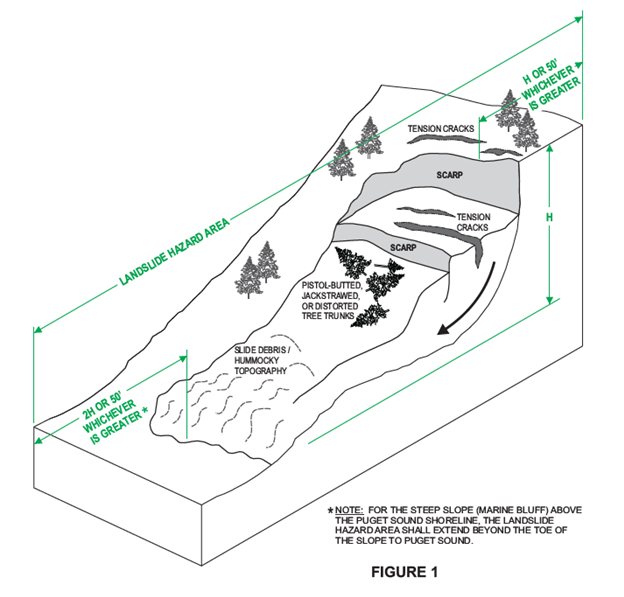
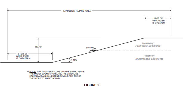
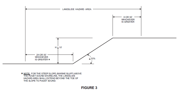
(Ord. 22-638 § 1 (Exh. A), 2022; Ord. 20-611 § 3 (Exh. C (part)), 2020)
16.10.620 Alteration of geologic hazard areas.
A. The Town shall approve, condition, or deny development, land disturbing, or land altering proposals in a geologic hazard area as appropriate based upon the effective mitigation of risks posed to property, health, and safety. The objective of mitigation measures shall be to render a site containing a critical geologic hazard as safe as one not containing such hazard. Conditions may include limitations of proposed uses, modification of density, alteration of site layout and other appropriate changes to the proposal. Where potential impacts cannot be effectively mitigated, or where the risk to public health, safety and welfare, public or private property, or important natural resources is significant notwithstanding mitigation, the proposal shall be denied unless it is subject to reasonable use as provided in Section 16.10.070.
B. Critical Erosion Hazard Areas. Development is allowed in critical erosion hazard areas subject to the following requirements:
1. The development is designed to comply with the recommendations of an approved geotechnical report.
2. The development utilizes best management practices (BMPs) and complies with other stormwater management requirements pursuant to Chapter 11.02.
3. The development does not adversely impact wetlands, streams, fish and wildlife habitat areas or their buffers.
4. The development complies with an approved temporary erosion and sedimentation control (TESC) plan.
C. Landslide Hazard Areas.
1. Development in Landslide Hazard Areas. Development in landslide hazard areas is allowed subject to the following requirements:
a. The development is designed to comply with the recommendations of an approved geotechnical report.
b. The geotechnical report demonstrates that landslide risks associated with the development will be mitigated sufficient to render a site containing a critical geologic hazard as safe as one not containing such hazard.
c. The project will not result in increased discharge of stormwater to the landslide hazard area.
d. The factor of safety of landslide occurrences shall not be decreased below the limits of 1.5 for static conditions or 1.1 for dynamic conditions. Analysis of dynamic conditions shall be based on a horizontal ground acceleration equal to one-half of the peak horizontal ground acceleration with a two percent in fifty-year probability of exceedance as established by the current version of the International Building Code.
e. Development in landslide hazard areas shall provide protection commensurate to being located outside of the landslide hazard area.
f. For projects in landslide hazard areas the Town shall require applicant funding of a qualified licensed geotechnical professional, selected and retained by the Town to review the applicant’s geotechnical report and recommendations.
2. Exceptions.
a. Alterations in landslide hazard areas for the purpose of slope stabilization shall be allowed to address slope instability that poses a significant risk to private party and/or public improvements. Although the requirements of subsection (C)(1) of this section shall generally apply to slope stabilization projects, the Town recognizes that these requirements may not be practical or feasible in all cases. For this reason, the Town reserves the right to modify these requirements when it is demonstrated by a qualified licensed geotechnical professional that there is a compelling reason and/or public benefit to do so. The burden shall be on the applicant to demonstrate a compelling reason and/or public benefit to allow the modification to the standard code requirements and consideration of the request for modification will be subject to independent third-party geotechnical review in accordance with subsection (C)(1)(f) of this section. In this case, the proposed slope stabilization work shall not result in increased risk to either the subject site or other properties. Existing conditions that pose significant risk may include, but are not necessarily limited to, active landslides that result in loss of ground, endangerment of existing structures or utilities, or significant erosion that poses an immediate threat to structures/utilities. Slope stabilization may not be used as a means of reducing setbacks or other recommended mitigation for new development as otherwise required by this chapter. For those projects where an exception to the standard code requirements is granted, the provisions of subsections E and F of this section will still apply.
D. Seismic Hazard Areas. Development activities or actions within a seismic hazard area may be allowed with an approved geotechnical report that confirms the site is suitable for the proposed development subject to the provisions of Sections 16.10.630 and 16.10.640.
E. Tsunami Hazard Areas. Development activities or actions requiring a project permit within two hundred feet of a tsunami hazard area shall comply with the identification, disclosure, and recording requirements of subsection D of this section. In tsunami hazard areas, applicants are encouraged to follow the recommendations from "Designing for Tsunamis: Seven Principles for Planning and Designing for Tsunami Hazards," by the National Tsunami Hazard Mitigation Program.
F. When development is permitted in geologic hazard areas by these regulations, the Town shall require an applicant and/or its licensed geotechnical engineer or engineering geologist to provide assurances that may include the following:
1. A letter under seal from a licensed geotechnical engineer or engineering geologist shall be recorded with Snohomish County that states that, in the engineer’s or engineering geologist’s professional opinion, all needed surface and subsurface soil explorations have been completed, a thorough review has been made of public records, and all needed analysis has been completed such that if the engineer’s or engineering geologist’s recommendations are followed any recommended structure will be as safe on the site containing the critical geologic hazard as it would be on a site not containing such hazard and that the use of the site according to the engineer’s or engineering geologist’s recommendations will not increase the likelihood of damage to neighboring properties;
2. A legal statement shall be recorded and noted on the face of the deed and on any new plat, executed in a form satisfactory to the Town, which characterizes the site as being located in a geologic hazard area, and which states there may be risks associated with development of such site, and which references the engineer’s or engineering geologist’s recorded letter required by subsection (F)(1) of this section;
3. A covenant between the owner(s) of the property and the Town prior to issuance of any permit or approval. The covenant shall not be required where the permit or approval is for work done by the Town. The covenant shall be tailored to the specific types of risks presented, shall be signed by the owner(s) of the property, shall be notarized, shall run with the land, shall be recorded with the Snohomish County Recorder’s Office at the expense of the owner, and shall include, but need not be limited to, the following:
a. A legal description of the property;
b. A description of the geologic hazard area;
c. As relevant to the property condition, commitment by the owner to maintain features of the site in such condition and such manner as will prevent harm to the public, to residents of the property, to nearby property, to streets, alleys and drainage facilities, from the activities to be done pursuant to the permit and from the related changes to the site, and to indemnify the Town and its officers, employees, contractors and agents from any claims arising from the failure of the owner to comply with the commitment;
d. A statement that the owner(s) of the property understands and accepts the responsibility for the risks associated with development on the property given the described condition, and agrees, through recording of the covenant with the Snohomish County Auditor’s Office, to inform future purchasers and other successors and assignees of the risks;
e. The application date, type, and number of the permit or approval for which the covenant is required; and
f. A waiver and release of any right of the owner(s), the owner’s heirs, successors and assigns to assert any claim against the Town and its officers, employees, contractors, and agents by reason of or arising out of issuance of the permit or approval by the Town for the development on the property, or arising out of any inspection, statement, assurance, delay, act or omission by or on behalf of the Town related to the permit or approval or the work done thereunder, and agreeing to defend and indemnify the Town and its officers, employees, contractors and agents for any liability, claim or demand arising out of any of the foregoing or out of work done or omitted by or for the owner, except in each case only for such losses, claims or demands that directly result from the sole negligence of the Town; and
4. A bond, guarantee, or other assurance device reviewed and approved by the Town to cover the cost of monitoring, maintenance, and any necessary corrective actions.
G. Stormwater conveyance and groundwater collection and conveyance facilities may be allowed to encroach into geological hazard areas on a case-by-case basis and upon geotechnical evidence that there are no other practical locations for these facilities and that the installation of such facilities will not detrimentally affect adjacent properties or ecosystems.
H. Tree removal and topping within geologic hazard areas shall comply with Chapter 16.12. (Ord. 22-638 § 1 (Exh. A), 2022; Ord. 20-611 § 3 (Exh. C (part)), 2020)
16.10.630 Geologic hazard area performance standards.
A. Relevant performance standards from Sections 16.10.330, 16.10.430 and 16.10.530, as determined by the Town, shall be incorporated into mitigation plans.
B. The following additional performance standards shall apply to proposals within geologic hazard areas:
1. Geotechnical reports shall be prepared by a qualified geotechnical engineer or engineering geologist licensed in the state of Washington, with experience analyzing geologic, hydrologic, and groundwater flow systems, and who has experience preparing reports for the relevant type of hazard. Geotechnical reports for projects in geologically hazardous areas shall be subject to independent review;
2. Site planning should minimize disruption of existing topography and natural vegetation;
3. Impervious surface coverage should be minimized;
4. Disturbed areas should be replanted as soon as feasible pursuant to an approved landscape plan;
5. Clearing and grading regulations as set forth by the Town shall be followed;
6. Grading is generally discouraged in landslide hazard areas. Any grading proposed in a landslide hazard area must be reviewed by the geotechnical engineer or engineering geologist in accordance with subsection (B)(16) of this section;
7. For landslide hazard areas, the factor of safety of landslide occurrences shall not be decreased below the limits of 1.5 for static conditions or 1.1 for dynamic conditions. Analysis of dynamic conditions shall be based on a horizontal ground acceleration equal to one-half of the peak horizontal ground acceleration with a two percent in fifty-year probability of exceedance as established by the current version of the International Building Code;
8. Temporary erosion and sedimentation controls, pursuant to an approved plan, shall be implemented during construction;
9. Where required in accordance with Section 16.10.650, a monitoring program, reviewed and approved by the Town, shall be prepared for construction activities permitted in geologic hazard areas;
10. Development shall not create a hazard to the site or adjacent properties, or result in significant sedimentation or erosion that adversely impacts surface water or other sensitive receptors, or poses a threat to structures/utilities;
11. The development will not increase or concentrate surface water discharge or sedimentation to adjacent sites beyond predevelopment conditions;
12. The development will not decrease slope stability on adjacent sites;
13. Structures and improvements shall be located, and clustered if appropriate, to preserve the most critical portion of the site and its natural landforms and vegetation;
14. Construction of trails shall meet the following criteria:
a. Constructed of permeable or semi-permeable materials;
b. Designed to minimize impact on the environmentally critical area;
c. Have a maximum trail surface width of five feet;
d. Meet all applicable requirements in Chapter 16.08;
15. Prohibited Development. On-site sewage disposal systems, including drain fields, shall be prohibited within landslide and erosion hazard areas;
16. Geotechnical Plan Review. Written acknowledgement from the licensed geotechnical engineer or engineering geologist who prepared the geotechnical report that they have reviewed the project plans and that they conform to their recommendations.
17. Geotechnical Construction Monitoring. A qualified geotechnical professional, working under the supervision of a licensed geotechnical engineer or engineering geologist must provide on-site monitoring of key earthwork activities including, but not limited to, temporary and permanent erosion control, structural fill placement and compaction, excavation of temporary cut slopes, pile and shoring installation, verification of foundation subgrade preparation, and subsurface drainage installation. Observations must be documented in daily written field reports. Upon completion of the work, the licensed geotechnical engineer or engineering geologist must provide a final letter verifying that the work was completed in accordance with the recommendations of the geotechnical professional’s reports and recommendations, and geotechnical-related permit requirements. (Ord. 22-638 § 1 (Exh. A), 2022; Ord. 20-611 § 3 (Exh. C (part)), 2020)
16.10.640 Geotechnical report--Required information.
A geologic hazard area report shall include, at a minimum, the following information:
A. Aerial extent of the proposed project or activity, including all lands within two hundred feet of such proposed project or activity.
B. Geologic Hazards Assessment. An environmentally critical areas report for a geologically hazardous area shall contain an assessment of geologic hazards including the following site- and proposal-related information at a minimum:
1. Site and Construction Plans. The report shall include a copy of the site plans for the proposal showing:
a. The type and extent of geologic hazard areas, any other critical areas, and buffers on, adjacent to, within two hundred feet of, or that are likely to impact the proposal;
b. Proposed development, including the location of existing and proposed structures, fill, storage of materials, and drainage facilities;
c. The topography, in minimum five-foot contours, as determined by the Director, of the project area and all hazard areas addressed in the report; and
d. Clearing limits.
2. Assessment of Geological Characteristics. The report shall include an assessment of the geologic characteristics of the soils, sediments, and/or rocks of the project area and potentially affected adjacent properties, and a review of the site history regarding landslides, erosion, and prior grading. Soils analysis shall be accomplished in accordance with accepted classification systems in use in the region. The assessment shall include, but not be limited to:
a. A description of the surface and subsurface geology, hydrology, soils, and vegetation found in the project area and in all hazard areas addressed in the report;
b. A detailed overview of the field investigations, published data, and references; data and conclusions from past assessments of the site; and site-specific measurements, tests, investigations, or studies that support the identification of geologically hazardous areas;
c. Subsurface exploration logs with soil descriptions in accordance with the Unified Soil Classification System. The logs shall identify the geologic units present (e.g., fill, landslide deposits, Vashon lodgement till, Vashon advance outwash, etc.). The subsurface explorations completed for the study must provide sufficient subsurface characterization to assess the geologic hazards of concern;
d. Identification of existing fill areas;
e. The locations of seeps, springs, or other surface expressions of groundwater;
f. The depth to groundwater and estimates of potential seasonal fluctuations, if applicable to the project;
g. For projects in landslide hazard areas, a discussion of the presence or absence of site features potentially indicative of historic landslide activity or increased risk of future landslide activity. Such features include, but are not limited to, tree trunk deformation, landslide scarps, springs, tension cracks, reversed slope benches, hummocky topography, vegetation patterns, and area stormwater management practices;
h. For projects in landslide hazard areas, a current LIDAR-based shaded relief map of the project area and a discussion regarding the presence or absence of geomorphic features indicative of historic landsliding;
i. An assessment of the risk of erosion hazards; and
j. A description of the vulnerability of the site to seismic and other geologic events.
3. Analysis of Proposal. The report shall contain a hazards analysis including a detailed description of the project, its relationship to the geologic hazard(s), and its potential impact upon the hazard area, the subject property, and affected adjacent properties. Where appropriate, the report shall also include the following information:
a. For projects in landslide hazard areas, the geotechnical report shall include the results of a quantitative slope stability analysis. The assessment of slope stability under dynamic conditions shall be based on a horizontal ground acceleration with a two percent in fifty-year probability of exceedance as defined in the current version of the International Building Code. The report shall also include an assessment of the present stability of the subject property, the stability of the property during construction, and the stability of the subject property after all development activities are completed. The assessment should include a discussion of the potential risks to other potentially impacted properties;
b. For projects in seismic hazard areas, the geotechnical report shall include an assessment of seismic hazards applicable to the project, such as liquefaction and/or lateral spreading. In areas subject to liquefaction, an estimate of the magnitude of seismically induced settlement that could occur during a seismic event. Estimation of the magnitude of seismically induced settlement shall be based on a peak horizontal ground acceleration based on a seismic event with a two percent in fifty-year probability of exceedance as defined in the current version of the International Building Code;
c. For projects in critical erosion hazard areas, the geotechnical report shall include a discussion of the sensitivity of the site to erosion hazards and provide recommendations to mitigate the hazards present;
d. For projects in or within two hundred feet of a tsunami hazard area, the geotechnical report shall disclose the presence of the tsunami hazard area and comply with the requirements of Section 16.10.620(E).
4. Geologic Hazard Mitigation. The report shall include recommendations to mitigate geologic hazards of concern based upon the geotechnical analysis.
5. Seismic Design Criteria. The report shall include the seismic site class for structural design when applicable to the project.
6. Geotechnical Design Recommendations. The report shall include geotechnical design recommendations applicable to the project. Such recommendations may include, but may not be limited to, types of suitable foundations, allowable footing or pile capacities, minimum footing depths, floor slab support recommendations, retaining wall design criteria, grading recommendations, and drainage recommendations.
C. Incorporation of Previous Study. Where a valid environmentally critical areas report has been prepared within the last five years for a specific site, and where the proposed land use activity and surrounding site conditions are unchanged, said report may be incorporated into the required environmentally critical areas report. The applicant shall submit a hazards assessment detailing any changed environmental conditions associated with the site or updated code requirements.
D. Mitigation of Long-Term Impacts. When hazard mitigation is required, the mitigation plan shall specifically address how the activity maintains or reduces the preexisting level of risk to the site and adjacent properties on a long-term basis (equal to or exceeding the projected lifespan of the activity or occupation). Proposed mitigation techniques shall be considered to provide long-term hazard reduction only if they do not require regular maintenance or other actions to maintain their function. Mitigation may also be required to avoid any increase in risk above the preexisting conditions following abandonment of the activity. (Ord. 22-638 § 1 (Exh. A), 2022; Ord. 20-611 § 3 (Exh. C (part)), 2020)
16.10.650 Geologic hazard area mitigation monitoring and maintenance.
The Town shall have authority to require annual monitoring of mitigation activities and submittal of annual monitoring reports in accordance with Sections 16.10.230, 16.10.340, 16.10.540 and this section to ensure and document that the goals and objectives of the mitigation are met. The frequency and duration of the monitoring shall be based on the specific needs of the project as determined by the Town. (Ord. 22-638 § 1 (Exh. A), 2022; Ord. 20-611 § 3 (Exh. C (part)), 2020)
16.10.700 Classification and rating of aquifer recharge and wellhead protection areas.
The classification of aquifer recharge and wellhead protection areas shall be based on the criteria established in WAC 365-190-080(2), including the categories of low, medium and high significance. Classification depends on the combined effects of hydrogeological susceptibility to contamination and contaminant loading potential, and presence of municipal water wellhead areas, as follows:
A. Low Significance/Low Susceptibility Recharge Areas. Upland areas underlain by soils consisting largely of silt, clay, or glacial till;
B. Medium Significance/Moderate Susceptibility Recharge Areas. Upland areas underlain by soils consisting largely of sand and gravel;
C. High Significance/High Susceptibility Recharge Areas. Wellhead protection areas and areas underlain by soils consisting largely of sand and gravel in which there is a predominantly downward or lateral component to groundwater flow, and which serve as a source of drinking water. (Ord. 20-611 § 3 (Exh. C (part)), 2020)
16.10.710 Alteration of aquifer recharge and wellhead protection areas.
A. The following land uses and activities shall be prohibited in critical (high significance/high susceptibility) aquifer recharge and wellhead protection areas:
1. Land uses and activities that involve the use, storage, transport, or disposal of significant quantities of chemicals, substances, or materials that are toxic, dangerous, or hazardous, as those terms are defined by state and federal regulations;
2. On-site community sewage disposal systems;
3. Underground storage of chemicals;
4. Petroleum pipelines;
5. Solid waste landfills;
6. Activities that substantially divert, alter, or reduce the flow of surface water or groundwater, or otherwise adversely affect aquifer recharge;
7. Other activities that the Town determines would significantly degrade groundwater quality and/or reduce the recharge to aquifers currently or potentially used as a significant source of base flow to a regulated stream. The determination must be made based on credible scientific information.
B. Medium or Low Significance Recharge Areas. Development within medium or low significance aquifer recharge and wellhead protection areas, as those terms are defined in these regulations, shall implement the mitigation standards contained in Sections 16.10.190 through 16.10.220, 16.10.330, 16.10.430, 16.10.530, 16.10.630 and 16.10.720. (Ord. 20-611 § 3 (Exh. C (part)), 2020)
16.10.720 Aquifer recharge and wellhead protection area performance standards.
Any uses or activities located in aquifer recharge and wellhead protection areas of medium or high significance that involve the use, storage, transport, or disposal of significant quantities of chemicals, substances, or materials that are toxic, dangerous, or hazardous, as those terms are defined by state and federal regulations, shall comply with the following additional standards:
A. Development within aquifer recharge and wellhead protection areas of high significance, as that term is defined in these regulations, shall prepare a materials management plan for review and approval by the Town, which shall implement the following measures:
1. Development should be clustered and impervious surfaces limited where possible;
2. Underground storage of chemicals, substances, or materials that are toxic, hazardous, or dangerous is discouraged;
3. Any chemicals, substances, or materials that are toxic, hazardous, or dangerous shall be segregated and stored in receptacles or containers that meet state and federal standards;
4. Storage containers shall be located in a designated secured area that is paved and able to contain leaks and spills, and surrounded by a dike;
5. Secondary containment devices shall be constructed around storage areas that are sufficient to prevent the spread of any spills, and a monitoring system shall be implemented;
6. A written operations plan shall be developed, including procedures for loading/unloading liquids and for training of employees in proper materials handling;
7. An emergency response/spill clean-up plan shall be prepared and employees properly trained in reacting to accidental spills;
8. Any aboveground storage tanks shall be located within a diked area on an impervious surface. The tanks shall include overfill protection systems and positive controls on outlets to prevent uncontrolled discharges;
9. No waste liquids or chemicals of any kind shall be discharged to storm sewers; and
10. All development shall implement best management practices (BMPs) for water quality, as approved by the Town, such as biofiltration swales and use of oil-water separators, and BMPs appropriate to the particular use proposed.
B. In addition to the management plan addressed in subsection A of this section, a hydrological report for aquifer recharge areas shall, at a minimum, include the following additional site and proposal related information:
1. Available information regarding geologic and hydrogeologic characteristics of the site, including the surface location of all critical aquifer recharge areas located on site or immediately adjacent to the site, and permeability of the unsaturated zone;
2. Groundwater depth, flow direction, and gradient based on available information;
3. Currently available data from wells;
4. Best management practices proposed to be used;
5. Groundwater monitoring plan provisions;
6. Discussion of the effects of the proposed project on the groundwater quality and quantity, including predictive evaluation of groundwater withdrawal effects on nearby wells and surface water features and predictive evaluation of contaminant transport based on potential releases to groundwater.
Figure 3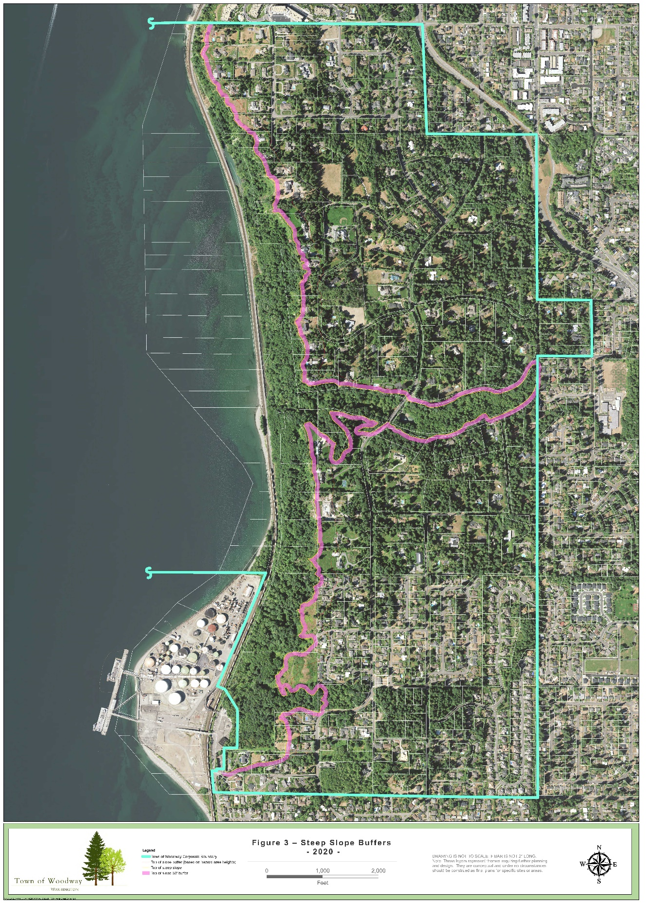
(Ord. 20-611 § 3 (Exh. C (part)), 2020)