


Chapter 18.12
DIMENSIONAL STANDARDS
Sections:
18.12.020 Tables of dimensional standards.
18.12.030 Additional dimensional provisions.
18.12.040 Modifications to required setbacks and heights.
18.12.050 Rules of measurement.
18.12.010 General.
A. All development in the city of Bainbridge Island shall be subject to the dimensional standards in Tables 17.12.070-1, 18.12.020-2 and 18.12.020-3 and BIMC 18.12.030, unless those standards are explicitly varied by another provision of the Bainbridge Island Municipal Code.
B. Lots that have previously received final approval from the city, or that have previously received final approval from Kitsap County prior to inclusion within the city boundaries, and that do not comply with the adopted flexible lot design requirements shall be considered existing nonconforming lots, but any future resubdivision of any such lots shall comply with adopted flexible lot design requirements. Preexisting PUDs may have their own standards that do not match those in Table 18.12.020-2 or 18.12.020-3.
C. In addition, the following sections of the BIMC may impose additional dimensional requirements or allow exceptions to dimensional requirements and, in the case of a conflict with the information in Table 18.12.020-2 or 18.12.020-3, the more specific provision or criteria shall apply:
1. BIMC 2.16.020.S, Housing Design Demonstration Projects.
2. Chapter 16.12 BIMC, Shoreline Master Program.
3. Chapter 16.20 BIMC, Critical Areas.
4. BIMC 17.12.030.A, flexible lot subdivision open space development option.
5. BIMC 17.12.030.B, flexible lot subdivision cluster development option.
6. BIMC 18.09.030, Use-specific standards.
7. BIMC 18.12.030.F, Shoreline Structure Setbacks.
8. Chapter 18.27 BIMC, Transfer of Development Rights. (Ord. 2011-02 § 2 (Exh. A), 2011)
18.12.020 Tables of dimensional standards.
Tables 18.12.020-2 and 18.12.020-3 set forth applicable dimensional standards. Where a property is located in more than one zone district, units permitted by density calculations within each zone district must be constructed on the portion of the property located within that zone district and required setbacks for each zone district must be met. Permitted densities are not “blended” across the zone district line.
Table 18.12.020-1. Repealed by Ord. 2019-03.
|
ZONING DISTRICT |
R-0.4 |
R-1 |
R-2 |
R-2.9 |
R-3.5 |
R-4.3 |
R-5 |
R-6 |
R-8 |
R-14 |
|---|---|---|---|---|---|---|---|---|---|---|
|
DIMENSIONAL STANDARD |
||||||||||
|
MINIMUM LOT AREA |
||||||||||
|
Note: Additional regulations on lot dimensions may apply pursuant to: |
||||||||||
|
(a) BIMC 17.12.030.A, flexible lot subdivision open space development option, or |
||||||||||
|
(b) BIMC 17.12.030.B, flexible lot subdivision cluster development option. |
||||||||||
|
Standard Lots |
100,000 sq. ft. |
40,000 sq. ft. |
20,000 sq. ft. |
15,000 sq. ft. |
12,500 sq. ft. |
10,000 sq. ft. |
8,500 sq. ft. |
7,260 sq. ft. |
5,400 sq. ft. |
3,100 sq. ft. |
|
MAXIMUM DENSITY (Minimum lot area per dwelling unit) |
||||||||||
|
Note: Additional regulations on density may apply pursuant to: |
||||||||||
|
(a) BIMC 16.20.160.F.5.a, Additional Development Standards for Regulated Uses, Land Divisions and Land Use Permits, Density Calculation. |
||||||||||
|
Standard Lots |
|
|||||||||
|
Base Density |
100,000 sq. ft. |
40,000 sq. ft. |
20,000 sq. ft. [1] |
15,000 sq. ft. [2] |
12,500 sq. ft. [2] |
10,000 sq. ft. [2] |
8,500 sq. ft. |
7,260 sq. ft. |
5,400 sq. ft. |
3,100 sq. ft. |
|
Bonus Density pursuant to BIMC 18.12.030.A |
N/A |
N/A |
N/A |
N/A |
N/A |
N/A |
N/A |
N/A |
3,630 sq. ft. |
2,074 sq. ft. |
|
MINIMUM LOT DIMENSIONS |
||||||||||
|
Note: Additional regulations on lot dimensions may apply pursuant to: |
||||||||||
|
(a) BIMC 17.12.030.A, flexible lot subdivision open space development option, or |
||||||||||
|
(b) BIMC 17.12.030.B, flexible lot subdivision cluster development option. |
||||||||||
|
Standard Lots |
|
|
|
|
|
|
|
|
|
|
|
Depth |
110 ft. |
80 ft. |
80 ft. |
N/A |
N/A |
N/A |
N/A |
60 ft. |
60 ft. |
60 ft. |
|
Width |
110 ft. |
80 ft. |
80 ft. [70 ft. for lots that abut the shoreline] |
N/A |
N/A |
N/A |
N/A |
60 ft. |
60 ft. |
60 ft. |
|
MAXIMUM LOT COVERAGE |
||||||||||
|
Standard Lots |
|
|||||||||
|
Base |
10% |
15% |
20% |
25% |
25% |
25% |
25% |
N/A |
25% |
40% |
|
Bonus |
N/A |
N/A |
N/A |
N/A |
N/A |
N/A |
N/A |
N/A |
40% Pursuant to BIMC 18.12.030.A |
50% Pursuant to BIMC 18.12.030.B |
|
MINIMUM SETBACKS |
||||||||||
|
Note: Landscaped areas may serve as setbacks (i.e., setbacks are not in addition to landscaped areas), and some encroachments into setback areas are permitted pursuant to BIMC 18.12.040. |
||||||||||
|
Note: Additional setbacks may be required by: |
||||||||||
|
(b) Chapter 16.20 BIMC, Critical Areas, or |
||||||||||
|
(c) BIMC 16.28.040, mining regulations, or |
||||||||||
|
(d) BIMC 18.09.030, Use Specific Standards, or |
||||||||||
|
(e) BIMC 16.12.030.B.3.i, Regulations – Shoreline Structure Setback View Requirement, or |
||||||||||
|
(f) BIMC 18.15.010, Landscaping and Screening. |
||||||||||
|
Standard Lots |
|
|||||||||
|
Front/Street |
|
|||||||||
|
2 stories or less |
25 ft. |
25 ft. |
5 ft. from edge of paved portion of Point Monroe Dr. |
25 ft. |
||||||
|
More than 2 stories |
Add 4 feet for each story over 2 stories [3] |
|
Same as for R-0.4 through R-5 |
|||||||
|
Side (not adjacent to street) |
|
|||||||||
|
2 stories or less |
15 ft. each side |
10 ft. min., 25 ft. total |
5 ft. min., 15 ft. total |
5 ft. min., 15 ft. total |
5 ft. min., 10 ft. total |
5 ft. min., 15 ft. total |
||||
|
More than 2 stories |
Add 5 ft. on each side, and 10 ft. to the total setback required, for each story over 2. If there is only one side yard, it is increased by 5 ft. for each story over 2 [3] |
Same as for R-0.4 through R-5 |
||||||||
|
Rear (not adjacent to street) |
|
|||||||||
|
2 stories or less |
25 ft. |
15 ft. |
15 ft. |
15 ft. |
15 ft. |
|||||
|
More than 2 stories |
Add 4 feet for each story over 2 [3] |
Same as for R-0.4 through R-5 |
||||||||
|
Shoreline Jurisdiction |
See Table 16.12.030-2, Dimensional Standards Table, and BIMC 16.12.030.B.3.i, Regulations – Shoreline Structure Setback View Requirement. |
|||||||||
|
MAXIMUM BUILDING AND STRUCTURE HEIGHT [4] |
||||||||||
|
Note: Bonus may not be available in the shoreline jurisdiction |
||||||||||
|
All lots |
|
|||||||||
|
Base |
30 ft. |
30 ft. |
25 ft. |
30 ft. |
35 |
|||||
|
Bonus for Nonresidential Uses If Conditional Use Permit Conditions Met |
35 ft. |
35 ft. |
30 ft. |
35 ft. |
40 ft. |
40 ft. See BIMC 18.12.030.B |
||||
|
Exemption |
Alternative height limits may apply for nonresidential uses if additional conditional use permit provisions of BIMC Title 2 are met. Some encroachments through height limits are permitted under BIMC 18.12.040. |
|||||||||
|
Shoreline Jurisdiction |
See Table 16.12.030-2, Dimensional Standards Table, and BIMC 16.12.030.B.3.i, Regulations – Shoreline Structure Setback View Requirement. |
|||||||||
[1] The base density for that parcel in the Lynwood Center special planning area designated as R-2 is one unit per 20,000 sq. ft., but may be increased up to 3 units per acre; provided, that a public access easement is granted for that portion of the parcel that lies to the south of Point White Drive along the waters of Rich Passage. The base density of some parcels in the Fort Ward historic overlay district may be increased as shown in BIMC 18.24.110.
[2] Pursuant to Chapters 18.18 and 18.27 BIMC the minimum lot area for a dwelling unit shall be 5,400 square feet for that area designated on the official land use map as the urban single-family overlay district (R-8SF). All other requirements of this chapter shall apply.
[3] Additional setbacks for taller buildings must be from the ground upward – i.e., this is not a “step-back” requirement for upper floors.
[4] For community and educational facilities (as listed in Table 18.09.020), spires, towers and other vertical features with horizontal cross-sections no more than five percent of the footprint of the primary structure may have a maximum height of 10 feet above the maximum base height, and shall be reviewed through a conditional use permit.
|
ZONING DISTRICT |
Winslow Mixed Use Town Center |
HSR I and II |
NC |
B/I |
WD-I |
||||
|---|---|---|---|---|---|---|---|---|---|
|
DIMENSIONAL STANDARD |
Central Core Overlay |
Madison Avenue Overlay |
Ericksen Avenue Overlay |
Gateway Overlay |
Ferry Terminal Overlay [See BIMC 18.12.030.C] |
||||
|
MAXIMUM FAR (Floor Area Ratio) [1] |
|||||||||
|
Basic Maximum |
|
||||||||
|
Commercial and Other Nonresidential Uses |
0.6 |
0.4 |
0.3 |
0.15 |
0.1 |
0.3 |
No max.; limited by other standards |
||
|
Residential |
0.4 |
0.4 |
0.3 |
0.5 |
0.4 |
0.3 |
No FAR limit: R-2 standards apply |
||
|
Mixed Use [2] |
1.0 |
0.5 |
0.5 |
0.5 |
0.5 |
0.3 |
No max.; limited by other standards |
||
|
Maximum with Bonus |
Bonus densities require compliance with BIMC 18.12.030.E and 18.21.050 as applicable. |
|
|||||||
|
Residential |
1.0 |
0.6 |
0.6 |
1.0 |
1.1 |
0.6 |
Bonus densities require compliance with BIMC 18.12.030.D |
N/A |
N/A |
|
Affordable Housing Development on Property Owned or Controlled by a Religious Organization [7] |
1.1 |
0.8 |
0.75 |
1.25 |
1.2 |
0.75 |
Bonus densities require compliance with BIMC 18.21.050 and 18.12.030.D |
N/A |
N/A |
|
Mixed Use [2] |
1.5 |
1.0 |
0.9 |
1.0 |
1.2 (1.4 pursuant to note [3]) |
0.9 |
|
N/A |
N/A |
|
MINIMUM LOT DIMENSIONS |
|||||||||
|
Area |
N/A |
N/A |
N/A |
N/A |
N/A |
N/A |
N/A |
20,000 sq. ft. |
20,000 sq.ft. |
|
Depth |
N/A |
N/A |
N/A |
N/A |
N/A |
N/A |
80 |
N/A |
N/A |
|
Width |
N/A |
N/A |
N/A |
N/A |
N/A |
N/A |
80 |
N/A |
N/A |
|
MAXIMUM LOT COVERAGE |
|||||||||
|
|
100%, excluding setbacks |
35% |
35% 2,500 sq. ft. max. building footprint south of Wyatt, excluding parking structures located below predevelopment and finished grade |
35% |
75% |
50% |
35% |
35% |
50% |
|
SETBACKS (Minimum required unless otherwise noted) [4] |
|||||||||
|
Note: Landscaped areas may serve as setbacks and, in some cases, may exceed the setback requirements. |
|||||||||
|
Note: Additional setbacks may be required by: |
|||||||||
|
(a) Chapter 16.12 BIMC, Shoreline Master Program; or |
|||||||||
|
(b) Chapter 16.20 BIMC, Critical Areas; or |
|||||||||
|
(c) BIMC 16.28.040, mining regulations; or |
|||||||||
|
(d) BIMC 18.09.030, Use Specific Standards; or |
|||||||||
|
(e) BIMC 16.12.030.B.3.i, Regulations – Shoreline Structure Setback View Requirement. |
|||||||||
|
Front |
|
|
|
|
|
|
|
|
|
|
|
Commercial: 5 ft. max. from sidewalk; Residential: 10 ft. min. and 20 ft. max. from Madison Ave. sidewalk |
10 ft. min., 20 ft. max. |
15 ft. min., 20 ft. max. |
5 ft. max. from sidewalk |
5 ft. max. from sidewalk except as modified by transition standards in BIMC 18.12.030.C |
10 ft. max. from sidewalk |
0 ft. min., 20 ft. max from any street, planned right-of-way or road easement, unless otherwise provided under special planning area provisions |
50 ft. min. along any public right-of-way |
40 ft. min. from property in residential districts; 10 ft. min. for all other |
|
Side |
|
|
|
|
|
|
|
|
|
|
|
0 ft.; 5 ft. min. when property abuts the Madison Avenue or Ericksen Avenue overlay districts |
0 ft.; 5 ft. min. when property abuts the central core overlay district |
5 ft. min. |
0 ft. |
0 ft. |
0 ft. |
0 ft. when property abuts another NC zone; 15 ft. when property abuts a residential zone |
10 ft.; 50 ft. when abutting a residentially zoned property. The city may increase this to a maximum of 100 ft. depending on the type, scale, and intensity of the proposed use, subject to site plan review. |
40 ft. min. from property in residential districts; 10 ft. min. for all other |
|
Rear |
|
|
|
|
|
|
|
|
|
|
|
0 ft.; 5 ft. min. when property abuts the Madison Avenue or Ericksen Avenue overlay districts |
0 ft.; 5 ft. min. when property abuts the Central Core or Ericksen Avenue overlay districts |
0 ft.; 5 ft. min. when property abuts the central core or Madison Avenue overlay districts |
0 ft. |
0 ft. |
0 ft. |
0 ft. when property abuts another NC zone; 15 ft. when property abuts a residential zone |
15 ft. min.; 50 ft. min. when abutting a residential district. City may increase to a maximum of 100 ft. based on type, scale, and intensity of proposed use, subject to site plan review. |
40 ft. min. from property in residential districts; 10 ft. min. for all other |
|
Shoreline Jurisdiction |
See Table 16.12.030-2, Dimensional Standards Table, and BIMC 16.12.030.B.3.i, Regulations – Shoreline Structure Setback View Requirement |
||||||||
|
MAXIMUM BUILDING AND STRUCTURE HEIGHT [5] |
|||||||||
|
Note: Bonus may not be available in the shoreline jurisdiction |
|||||||||
|
Base |
35 ft.; 25 ft. max. south of Parfitt |
25 ft.; 35 ft. north of High School Road |
25 ft. |
35 ft. |
BIMC 18.12.030.C standard height north of Winslow Way; 35 ft. south of Winslow Way |
35 ft. |
35 ft. |
35 ft. |
35 ft. except that Chapter 16.12 BIMC applies within shoreline jurisdiction |
|
Bonus 1 if parking under building [6] |
45 ft.; 35 ft. south of Parfitt |
35 ft.; 45 ft. north of High School Road |
35 ft. |
45 ft. |
BIMC 18.12.030.C optional height north of Winslow Way; 45 ft. south of Winslow Way |
45 ft. |
|
|
|
|
Bonus 2 for Nonresidential Uses with Major Conditional Use Permit |
|
|
|
|
|
|
45 ft. |
45 ft. |
45 ft. |
|
Bonus 3 Structure Height |
Alternative height limits may apply if the conditional use permit provisions of BIMC Title 2 are met. Some encroachments through height limits are permitted under BIMC 18.12.040. |
||||||||
[1] If the existing FAR for a developed property as of May 21, 1998, is higher than the base FAR for that district, then the existing FAR will be considered the base FAR for that developed property. Total FAR may not be exceeded.
[2] In mixed use development, the established FAR in the residential and commercial components shall not be exceeded. For the residential FAR bonus provisions for qualifying housing design demonstration project, refer to the bonus density provisions in BIMC 2.16.020.S.8.
[3] In mixed use development in the ferry terminal district, an additional 0.2 FAR is permitted in accordance with BIMC 18.12.030.E.2. The additional FAR may be applied to either the residential or commercial component of the mixed use development.
[4] When property adjoins a single-family residential zone, building setback shall be in accordance with the landscape ordinance perimeter landscaping requirements.
[5] When property adjoins a lower density residential zone, except in the ferry terminal district, north of Winslow Way, for the first 30 feet of the building from the property line of an adjoining lower density residential zone, the building height shall be the building height of the adjoining lower density residential zone. Optional building height allowed in the adjoining lower density residential district through a conditional use permit may be requested for projects within the mixed use town center and high school road zones through the site plan review process. For building height requirements in the ferry terminal district, north of Winslow Way, reference BIMC 18.12.030.C.
[6] The bonus height is available when parking is located underground or under the occupiable space of the planned building. If parking is located under 50 percent or less of the occupiable space, the bonus may only be used for a portion of the building footprint twice as large as the area with parking located beneath.
[7] The bonus density is available when provisions of BIMC 18.21.050 are met and all bonus FAR is applied to the residential component of the mixed use development.
(Ord. 2022-161 § 1, 2022; Ord. 2022-02 § 2 (Exh. B), 2022; Ord. 2021-10 § 1 (Exh. A), 2021; Ord. 2020-03 § 3 (Exh. C), 2020; Ord. 2019-03 § 8, 2019; Ord. 2017-02 §§ 1, 22 (Exh. B), 2017; Ord. 2013-25 § 6 (Exh. B), 2013; Ord. 2012-10 § 1, 2012; Ord. 2011-02 § 2 (Exh. A), 2011)
18.12.030 Additional dimensional provisions.
A. Density and Lot Coverage Bonus for R-8 and R-14 Zone Districts.
1. An increase in density in the R-8 and R-14 zone districts may be granted pursuant to the requirements in Chapter 18.21 BIMC.
2. A density bonus not to exceed 50 percent may be granted to lands in the R-8 and R-14 zone districts if the applicant provides permanent, public open space, provided the following criteria are met:
a. The open space shall abut a public or private street and have adequate public access.
b. If the subject property being developed is a corner site, placement of the open space at the corner is preferred.
c. Signage shall be posted to notify that the open space is public and access is permitted.
d. The amount of the density bonus shall be twice the percentage of the total lot area that is designated as open space. For example, if 25 percent of the total lot area is designated as open space, a 50 percent density bonus may be achieved.
e. The minimum area designated as public open space must be the larger of (i) 10 percent of the total lot area or (ii) one-quarter acre.
f. If the open space is not contiguous, then each open space area must be at least one-quarter acre.
g. A 15-foot building setback shall be provided along the perimeters of the open space.
h. Trees retained within the designated open space may fulfill the significant tree/canopy retention requirements of BIMC 18.15.010.
i. The public open space density bonus may be combined with other density bonuses applicable to this zone; provided, that the total combined density bonus does not exceed 50 percent of the base density.
j. The open space shall be established as permanent, public open space through one of the following means through either public or private ownership. For purposes of this provision, public ownership means that the city or other public agency chooses to accept ownership of open space and that upon approval and acceptance by the director, open space shall be dedicated to the public. Private ownership means that the open space is held in private ownership if established by easements, restrictive covenants, or other similar legal means in which (i) public access and maintenance of the open space are adequately provided for by written agreement, and such agreements or covenants are recorded with the county auditor; and (ii) in the event that the open space is not maintained consistent with the agreement, the city shall have the right to provide the maintenance of the open space and bill the owner for the cost of maintenance.
k. Lands that are located in the critical areas overlay district, as identified in the comprehensive plan, are not eligible for the density bonus provided in this section.
l. In the R-8 zone district, no portion of any building within 20 feet of a front yard setback located across the street from a single-family residential zone shall exceed a height of 25 feet.
m. In the R-8 zone district, building design shall incorporate features such as pitched or terraced roof forms, upper level stepbacks, wall recesses and/or other architectural treatment to minimize building bulk and scale as perceived from adjoining streets and neighborhoods.
n. In the R-14 zone district, open space that is selected under the provisions of subsection B.7 of this section or required as mitigation for development impacts may not be included in the open space calculations related to the density bonus provided in this section.
3. When the density bonus provisions in subsection A.2 of this section are used, the maximum lot coverage in the R-8 and R-14 zone districts may be increased as follows:
a. In the R-8 zone district, the lot coverage may be increased to 40 percent;
b. In the R-14 zone district, the lot coverage may be increased 50 percent.
B. Additional Height in R-14 District. In the R-14 zone district, an applicant who requests additional lot coverage pursuant to subsection A.3 of this section shall not be allowed to also increase maximum allowable building height unless the applicant demonstrates that:
1. The applicable design guidelines are met; and
2. The criteria for conditional use permit approval of additional height in the R-14 district, as set forth in BIMC Title 2, are met; and
3. The increased height facilitates underground or enclosed under-building parking to the extent feasible; and
4. The building massing contains significant modulations; and
5. Thirty percent of the property must be retained as pervious surface area. Pervious surface areas can include landscaping, unpaved stormwater management facilities, underground or overhead utility lines, perimeter fences, and pervious trails. Setback areas and significant tree retention areas can count towards the required pervious surface area. Pervious surface area shall exclude areas covered by (a) structures, including decks, fountains, artwork, utility cabinets, lighting fixtures, trash enclosures, and signs; and (b) areas covered by paving and/or gravel, including sidewalks, impervious paths, patios, parking areas, and driveways; and
6. Mechanical equipment shall be enclosed or screened, and such enclosures or screening shall be architecturally integrated into the building design or landscape plan; and
7. The project provides one or more public amenities that would not otherwise be provided, such as greater significant tree retention or provision of more open space than is otherwise required, publicly accessible play areas, trails, or benches, or other amenities proposed by the applicant and approved by the city.
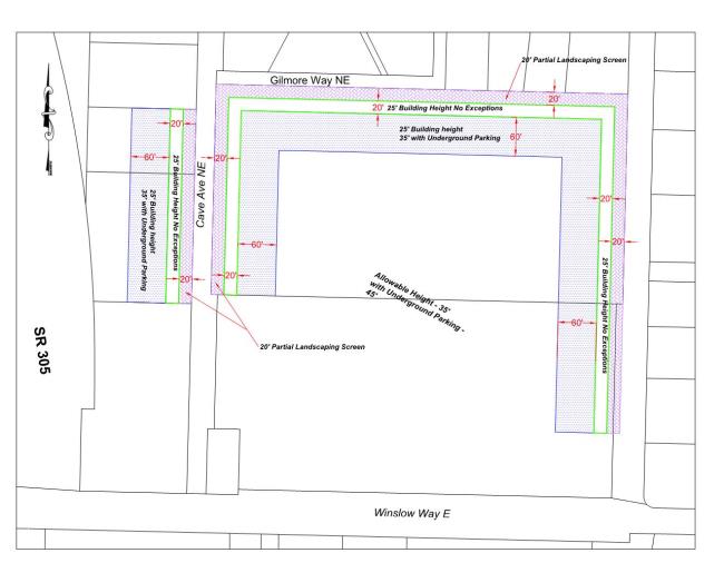
C. Transition Standards in the Ferry Terminal Overlay District. In order to protect adjacent neighborhoods, a 100-foot-wide transition area is established in the ferry terminal overlay zone, north of Winslow Way, as follows: along the west side of Ferncliff Avenue, starting approximately 100 feet north of Winslow Way; along the north boundary of the district, east of Cave Avenue; and along both sides of Cave Avenue, starting approximately 300 feet north of Winslow Way. The landscaping requirements and height restrictions illustrated below shall apply to this transition area. Portions of the ferry terminal overlay district that are not in the transition area designated by this section shall comply with all other applicable ferry terminal overlay district requirements.
D. Bonus Density in NC District. Bonus density shall be available in the NC district as follows:
1. Three units per acre with the provision of transfer of development rights (TDRs), in accordance with Chapter 18.27 BIMC; or
2. Three units per acre with the provision of affordable housing, in accordance with the provisions of Chapter 18.21 BIMC; or
3. Three units per acre if the development is commercial/residential mixed use and public sewer and public water are not provided, or five units per acre if the mixed use development is on public water and sewer. The residential units must be located above the ground floor if the building is located on a collector or secondary arterial or higher road classification; however, for mixed use projects, if the building fronts on a local or private street, residential units can be located on the ground floor.
a. In instances where a project contains both mixed use and residential-only buildings, the bonus density shall only be calculated based on the mixed use buildings. The residential-only buildings shall not be used to calculate the bonus density; or
4. Five units per acre with the provisions of TDRs and public sewer and water; or
5. Five units per acre with public water and sewer and the provision of affordable housing in accordance with Chapter 18.21 BIMC; or
6. Up to 12 units per acre for those specific parcels located in Lynwood Center and so designated on the land use map as NC/R-12 for the Lynwood Center special planning area; provided, that all requirements of this title applicable to the NC are met, and that:
a. The development is commercial/residential mixed use with the residential units located above the ground floor if the building is located on a collector or secondary arterial or higher road classification; however, for mixed use projects, if the building fronts on a local or private street, residential units can be located on the ground floor; and
b. Public sewer and water are provided; and
c. The requirements of Chapters 18.18 and 18.21 BIMC are met; and
d. A community center is constructed that is of similar style and quality to the entire development, is no less than 2,000 square feet, provides kitchen facilities, public rest rooms and outside access. The community center is to be used primarily for community functions.
E. Bonus Density to Incentivize Affordable Housing in Winslow Mixed Use and High School Road Districts. Eligible properties may achieve a maximum level of development above the base FAR, as provided for in Table 18.12.020-3, by using one, or a combination of, the following FAR bonus provisions. The FAR bonus provisions may be combined to achieve the maximum level of development established for each district. In no case shall the total commercial, residential or mixed use FAR exceed the maximum FAR as provided for in Table 18.12.020-3.
1. Optional Affordable Housing.
a. FAR Bonus. Up to 100 percent of the maximum residential FAR bonus may come from providing affordable housing as defined in Chapter 18.36 BIMC; provided, that the difference between the base residential FAR and the maximum residential FAR shall be dedicated to affordable housing. A portion of the total floor area that is of common use and benefit to the entire residential development (for example, interior halls, stairwells, laundry rooms, exercise rooms) may be included in the calculation of the affordable housing component. This portion shall be the same percentage as the affordable housing provided. For example, if 20 percent of the living unit floor area is for affordable housing, then 20 percent of the common floor area may be included in the total affordable housing calculation. Development of the optional affordable housing shall be in accordance with Chapter 18.21 BIMC and Table 18.12.030.
|
Size of Development |
Residential development less than 10,000 sq. ft. |
Residential development of 10,000 sq. ft. but less than 60,000 sq. ft. |
Residential development more than 60,000 sq. ft. |
|---|---|---|---|
|
Affordable Housing FAR Bonus |
Must provide 100 percent of bonus square footage for extremely low, very low, or moderate income groups. |
Must comply with following ratios: |
Must comply with following ratios: |
|
(a) 100 percent of bonus for all moderate; OR |
0.1 of bonus for extremely low, very low or low income groups; |
||
|
(b) 0.2 of bonus for extremely low, very low, or low income groups; |
0.6 of bonus for moderate income group; and |
||
|
0.5 of bonus for moderate income group; and |
0.3 of bonus for middle income group. |
||
|
0.3 of bonus for middle income group. |
|
b. Preservation of the Islander Mobile Home Park. Preservation of the Islander Mobile Home Park as an existing park site for manufactured homes shall be encouraged through the following provisions.
i. Unused FAR from the parcel on which the mobile home park is located may be transferred to another parcel or parcels within the Mixed Use Town Center. For example, the base FAR for the mobile home park would be calculated, less the FAR of the mobile homes. In exchange for permanently preserving the mobile home park, the owner of the property may transfer the unused FAR to another parcel or parcels in the Mixed Use Town Center, where it may be used as bonus FAR above the base FAR for that district.
ii. Permanent preservation of the mobile home park may be used as an affordable housing bonus on another parcel or parcels within the Mixed Use Town Center. For example, in exchange for preserving the mobile home park, the owner of the property would be deemed to have met the affordable housing bonus provisions of subsection A.1 of this section, and could achieve the maximum FAR bonus for residential development on another parcel or parcels in the Mixed Use Town Center. The owner of the mobile home park may either apply the FAR bonus to another parcel(s) he or she owns, or transfer or sell the bonus to another property owner in the Mixed Use Town Center.
2. Ferry-Related Parking. In the ferry terminal district, an additional 0.2 FAR may be achieved by relocating existing legal surface ferry commuter parking on site (as shown on Figure 6.2 of the Winslow master plan) to under-building or below-grade parking. The percentage of the additional FAR that is achieved shall be dependent upon the percentage of parking that is relocated. For example, if 50 percent of existing surface ferry commuter parking on site is relocated under-building or below grade, then 50 percent of the total additional FAR (or 0.1 FAR) may be achieved. (Ord. 2022-162 § 1, 2022; Ord. 2021-10 § 2, 2021; Ord. 2017-02 § 1, 2017; Ord. 2015-04 § 1, 2015; Ord. 2014-04 § 6 (Exh. 4 § 1), 2014; Ord. 2011-02 § 2 (Exh. A), 2011)
18.12.040 Modifications to required setbacks and heights.
A. Permitted Setback/Height Modifications. Minimum and maximum setbacks and maximum heights established in Tables 17.12.070-1, 18.12.020-2, and 18.12.020-3 and in BIMC 18.12.030 may be encroached as set forth in Table 18.12.040 and may also be modified by applicable provisions of adopted fire codes, the shoreline master program, and/or the building code. These modifications are not permitted in required perimeter or roadside buffers.
|
Type of Encroachment |
Encroachment Permitted |
Conditions |
|---|---|---|
|
Permitted Setback Modifications |
||
|
Fence or combined fence and berm up to 6 feet high |
In any required setback subject to applicable regulations in BIMC Title 15 |
Except as provided in BIMC 18.12.040.B and Chapter 16.12 BIMC |
|
Nonscreening fences or combined nonscreening fence and berm up to 8 feet high |
In any required setback subject to applicable regulations in BIMC Title 15 |
Except as provided in Chapter 16.12 BIMC |
|
Chimneys, flues, awnings, bay windows, and greenhouse windows |
Up to 18 inches into any required setback |
|
|
Covered porches, bay windows and eaves within the Ericksen Avenue overlay district |
Up to 5 feet into the front yard |
Bay windows must be cantilevered outward from the wall, and may not result in any portion of the building floor area extending into the setback |
|
Any structures, including but not limited to uncovered steps, porches, and decks less than or equal to 30 inches in height |
Up to 2 feet into front and side setbacks. Up to 5 feet into required rear setbacks. |
|
|
Eaves |
May extend up to 24 inches in any required setback except shoreline structure setback |
|
|
At or near grade structures such as uncovered patios, sidewalks, and driveways |
In any required setback |
May not exceed 4 inches in height |
|
Signs |
In any required setback |
Must conform to Chapter 15.08 BIMC |
|
Overhead or underground accessory utilities |
In any required setback, perimeter or roadside buffer |
Must conform to Chapters 16.12 and 16.20 BIMC. Does not apply to above ground utilities such as propane tanks. |
|
Composting bins |
In side or rear setback areas |
|
|
Bioretention/rain gardens |
In any required setback |
In accordance with Chapter 15.20 BIMC |
|
Rain barrels/cisterns |
In any required setback |
In accordance with Chapter 15.20 BIMC |
|
Wall-mounted on-demand hot water heaters |
Up to 18 inches into side or rear setbacks |
Permitted if buffered or enclosed to prevent noise impacts to neighboring properties |
|
Below-ground geothermal equipment |
In any required setback, perimeter or roadside buffer |
Must conform to Chapters 16.12 and 16.20 BIMC. Permitted if any excavated areas are promptly relandscaped after installation is complete. |
|
Rockeries and retaining walls less than 4 feet in height |
In any required setback |
Rockeries and retaining walls greater than 4 feet in height may be permitted with qualified geotechnical engineer determination, and city concurrence, that it is necessary for slope stabilization. |
|
Public communications tower |
In any required setback subject to applicable regulations in BIMC Title 15 |
|
|
Permitted Height Modifications |
||
|
Small wind energy generators |
Up to 18 inches above the maximum building height in the district |
|
|
Solar panels |
Up to 18 inches above the maximum building height in the district |
|
|
Noncommercial, nonparabolic antennas affixed to noncommercial communication towers |
Up to 50 feet in height above grade |
|
|
One flagpole per parcel |
Up to 45 feet in height above grade |
|
|
Public communications tower |
Up to 120 feet in height above grade |
A building permit is required for a public communications tower. A conditional use permit shall be required for a public communications tower to be constructed between 71 feet and 120 feet above grade. A public communications tower shall not exceed 120 feet in height. |
|
Distribution utility poles |
Up to 55 feet in height above grade |
Replacement poles over 55 feet in height, see BIMC 18.09.030.F.2.b. For new distribution utility facilities or corridors, see Table 18.09.020. Poles shall not be moved more than 20 feet from the original location unless permitted under BIMC 18.09.030.F.2.b. |
|
Transmission utility poles |
Up to a 25 percent increase above existing pole height above grade with a maximum height of 100 feet |
Replacement poles over the 25 percent increase or 100 feet in height, see BIMC 18.09.030.F.2.b. For new transmission utility facilities or corridors, see Table 18.09.020. Poles shall not be moved more than 20 feet from the original location unless permitted under BIMC 18.09.030.F.2.b. |
|
Utility structures existing on the effective date of the ordinance codified in this subsection |
Existing height |
May also be replaced or modified; provided, that the structure is not larger or taller than the original structure and is not moved more than 20 feet from its original location. |
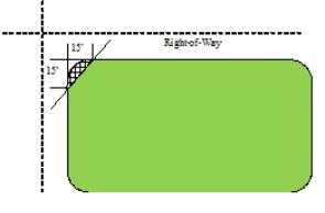
B. Sight Clearance. No sight-obscuring fence or hedge 42 inches or higher than the grade of adjacent streets shall be permitted on corner lots in the setback area formed by a line from the lot corner at the street intersection along the front setback line 15 feet and side setback line 15 feet and a line connecting the two lot lines at the points 15 feet from the intersection corner.
(Ord. 2020-03 § 3 (Exh. C), 2020; Ord. 2019-03 § 9, 2019; Ord. 2017-14 § 5 (Exh. B), 2017; Ord. 2016-28 § 11, 2016; Ord. 2014-05 § 2, 2014; Ord. 2011-02 § 2 (Exh. A), 2011)
18.12.050 Rules of measurement.
The following rules of measurement shall apply in determining compliance with the requirements of this title. When a required calculation results in a fraction greater than or equal to one-half, the requirement shall be rounded up to the next whole number.
A. Base Density. The “base density” of a property means the density designated on the zoning map, exclusive of any density bonuses.
B. Building Footprint. “Building footprint” is the area at the ground plane of a building, structure, or other element, bounded by the outside of the exterior walls.
C. Building Height. Building height is measured as the vertical distance above “grade” to the highest point of the coping of a flat roof or to the deck line of a mansard roof or to the average height of the highest gable of a pitched or hipped roof. The height of a stepped or terraced building is the maximum height of any segment of the building. The height measurement on an asymmetrical gable shall be the same as a shed roof; it shall be from grade to the midpoint of the longest segment; provided, that the asymmetrical building would not result in a taller building than a traditional symmetrical building. Building height is measured differently in the shoreline jurisdiction.
D. Density. “Density” means the number of dwelling units allowed in the lot area, not including accessory dwelling units. In zones that use floor area ratio (FAR) in place of units per acre, “density” means the maximum floor area allowed.
E. Fence Height. Fence height is measured from finished grade on the exterior side of the fence. Where fences are built on top of berms the maximum height of the fence shall apply to the combined fence and berm.
F. Floor Area. Floor area is measured as the total area of all floors within the exterior vertical walls of a building. If any room has a sloping ceiling, no portion of the room measuring less than five vertical feet from the finished floor to the finished ceiling shall be included in the computation of total area.
G. Floor Area Ratio (FAR). “Floor area ratio” is a figure that expresses the total floor area as a multiple of the lot area. This figure is determined by dividing the floor area of all buildings on a lot by the lot area prior to removal of lot area for dedication. Portions of parking located underground or underneath occupiable space are not counted in floor area ratio calculations. When an historic structure is preserved on site, the floor area ratio of that historic structure shall not be included in the calculation of total floor area ratio for the site. The historic structure must be included on a state, local, or federal register.
H. Front Setbacks. “Front setback” means a setback extending from a building, structure or use to the street or planned right-of-way.
I. Grade. “Grade” (adjacent ground elevation) is the computed average of the lowest and the highest points of elevation of the original surface of the ground, or existing paving or sidewalk within the area between the building and the property line, or when the property line is more than five feet from the building, between the building and a line five feet from the building. On waterfront parcels as defined in the shoreline master program, the definition of average grade level from the shoreline master programs shall be used (WAC 173-27-030(3)).
J. Lot Area. “Lot area” means the total horizontal area within the lot lines, excluding any area seaward of the line of the ordinary high water mark, and excluding private streets and lot area in panhandles or flag lots narrower than 30 feet.
K. Lot Coverage. “Lot coverage” means that portion of the total lot area covered by buildings, excluding up to 24 inches of eaves on each side of the building, any building or portion of building located below predevelopment and finished grade. Any portion of a slatted or solid deck located more than five feet above grade shall be counted towards lot coverage. Also excluded are ground-mounted accessory small wind energy generators, solar panels, composting bins, rain barrels/cisterns, and covers designed to shade ground-mounted heat pumps and air conditioners to increase their efficiency.
L. Lot Depth. “Lot depth” means the horizontal distance from the midpoint of the front lot line to the midpoint of the rear lot line, or to the most distant point on any other lot line where there is no rear lot line.
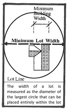
M. Lot Width. “Lot width” means the diameter of the biggest circle that can fit entirely inside the lot boundary line.
N. Rear Setback. “Rear setback” means a setback extending from a building, structure or use to the rear lot line. If a property has more than one front yard, then rear setback does not apply. In the shoreline jurisdiction, rear setback does not apply since native vegetation zone requirements exceed rear setback requirements.
O. Setback. “Setback” means the required distance measured horizontally between every building, structure or use and the lot lines, planned rights-of-way, rights-of-way or streets.
P. Side Setback. “Side setback” means a setback extending from a building, structure or use to the side lot line. When a parcel has two or more front setbacks, the remaining setbacks are to be considered side setbacks. If a property is bordered on three or more sides by streets, the minimum setback on the remaining side is the minimum setback required for that zone district. If the property is bordered on two sides by streets, the two remaining sides shall meet the minimum and total side setbacks. When a setback for an existing structure is smaller than the minimum required, the minimum for the second side setback does not need to make up the difference – the second side setback need only be as large as if the nonconforming side yard met its minimum requirement.
Q. Structure Height. “Structure height” is measured at the highest point above grade of a structure other than a building, except as otherwise provided by this code.
R. Through Lots – Accessory Building Setbacks. In through lots, setbacks for accessory buildings in rear setbacks shall conform to the front setback requirements for a principal building. Decks less than 36 inches in height extending into required rear and side setbacks may be attached to the principal building. (Ord. 2022-163 § 1, 2022; Ord. 2021-10 § 3, 2021; Ord. 2020-03 § 3 (Exh. C), 2020; Ord. 2016-28 § 12, 2016; Ord. 2014-04 § 6 (Exh. 4 § 2), 2014: Ord. 2011-02 § 2 (Exh. A), 2011)
Code reviser’s note: The amendments of Ordinance 2021-10 relating to bonus floor area ratio were set to expire one year after adoption of that ordinance. Ordinance 2022-16 extended those amendments to continue in effect until March 10, 2024.
Code reviser’s note: The amendments of Ordinance 2021-10 relating to bonus floor area ratio were set to expire one year after adoption of that ordinance. Ordinance 2022-16 extended those amendments to continue in effect until March 10, 2024.
Code reviser’s note: The amendments of Ordinance 2021-10 relating to bonus floor area ratio were set to expire one year after adoption of that ordinance. Ordinance 2022-16 extended those amendments to continue in effect until March 10, 2024.