


Division 13-10-012
Standards for Thoroughfares Applied in Traditional Neighborhood Districts
Sections:
13-10-012 Standards for Thoroughfares Applied in Traditional Neighborhood Districts
13-10-012-0001 Applying a Thoroughfare Type in a Traditional Neighborhood
13-10-012-0001.1 Transect Zone
13-10-012-0001.2 Speed/Movement Types
13-10-012-0001.3 Functions of Thoroughfares
13-10-012-0001.4 Other Considerations
13-10-012-0001.5 Arterials and Major Collectors as Described in Division 13-10-014
13-10-012-0002 Bicycle Facilities in Traditional Neighborhoods
13-10-012-0003 Special Districts
13-10-012-0004 Tables: Thoroughfare Standards in Traditional Neighborhood Districts
13-10-012-0005 Utilities in Traditional Neighborhood Districts
13-10-012-0005.1 Utility Placement in Thoroughfares in Traditional Neighborhood Developments
13-10-012-0005.2 Planning of Utilities in Traditional Neighborhood Developments
13-10-012-0006 Vehicular Parking/Right-of-Way Assemblies
13-10-012 Standards for Thoroughfares Applied in Traditional Neighborhood Districts
This chapter provides the standards for thoroughfares to be applied in traditional neighborhood districts as approved by the City Council based on the provisions of the City of Flagstaff Zoning Code.
New terms and concepts typically associated with traditional neighborhoods are introduced in this chapter and the zoning code. A general explanation of the concepts behind traditional neighborhood development is provided in Appendix 1.2 of the zoning code. Specific terms used throughout this chapter that are capitalized may refer to Chapter 10.80, Definitions, of terms for traditional neighborhood districts in the zoning code. (Ord. 2017-22, Rep&ReEn, 07/05/2017)
13-10-012-0001 Applying a Thoroughfare Type in a Traditional Neighborhood
Transect zones, speed/movement type, functions of thoroughfares, arterials as described in Division 13-10-014, and other considerations should be taken into account in determining the correct application of a thoroughfare type in a traditional neighborhood. (Ord. 2017-22, Rep&ReEn, 07/05/2017)
13-10-012-0001.1 Transect Zone
A. A traditional neighborhood district is based on the delineation of transect zones. Transect zones are ordered from the most natural to the most urban and they describe the physical character of place at any scale according to the density and intensity of urbanism. The urban form and character of a transect zone will dictate the type of thoroughfare that should be placed within or adjacent to it. Determining the urban form and character and its associated land uses first, and thoroughfare type secondarily, is critical to ensuring a thoroughfare system that accommodates all users (pedestrians, cyclists, public transit and automobiles) with an emphasis on walkability and pedestrian safety. The following types of transects may be applied in a traditional neighborhood.
1. T1 Natural Zone consists of lands approximating or reverting to a wilderness condition, including lands unsuitable for settlement due to topography, hydrology or vegetation.
2. T2 Rural Zone consists of sparsely settled lands in open or cultivated state. These include woodland, grasslands, parks and open space areas. Typical buildings are farmhouses, agricultural buildings or cabins.
3. T3 Sub-Urban Zone consists of low-density residential areas, adjacent to higher density zones that include some mixed use. Home occupations and outbuildings are allowed. Planting is naturalistic and setbacks are relatively deep. Blocks may be large and the roads irregular to accommodate natural conditions.
4. T4 General Urban Zone consists of mixed-use but primarily residential urban fabric. It may have a wide range of building types, such as single-family, sideyard buildings, and rowhouses. Setbacks and landscaping are variable. Streets with curbs and sidewalks define medium-sized blocks.
5. T5 Urban Center Zone consists of higher density mixed-use buildings that accommodate retail, offices, rowhouses and apartments. It has a tight network of streets and small blocks, with wide sidewalks, regularly spaced street planting, and buildings set close to the sidewalks.
6. T6 Urban Core Zone consists of the highest density and height, with the greatest variety of uses, and civic buildings of regional importance. It may have larger blocks, and streets have regularly spaced tree planting with buildings set close to the wide sidewalks. The T6 urban core is typically associated with downtown Flagstaff, thus this transect would not be applied in other locations within the City.
B. Special districts such as an industrial area or business park consist of areas with buildings that by their use, placement or configuration cannot, or should not, conform to one (1) or more of the six (6) normative transect zones. (Ord. 2017-22, Rep&ReEn, 07/05/2017)
13-10-012-0001.2 Speed/Movement Types
A. The design speed for pedestrian safety and mobility is the primary determinant of movement types. Movement types associated with assigned lane widths and curb radii are applied in each transect zone.
1. YIELD: Drivers must proceed slowly, with extreme care and must yield to approaching traffic when vehicles are parked on both sides of the thoroughfare. A yield street is the functional equivalent of traffic calming. Design speed of twenty (20) miles per hour or less.
2. SLOW: Drivers can proceed carefully with an occasional stop to allow a pedestrian to cross or another car to park. The character of the street should make drivers uncomfortable exceeding the design speed due to the presence of parked cars, sense of enclosure from buildings and street trees, tight turning radii, and other design elements. Design speed of twenty (20) miles per hour.
3. FREE: Drivers can generally expect to travel without delay at the appropriate design speed. Street design supports safe pedestrian movement at the higher design speed. This movement type is appropriate for thoroughfares designed to traverse longer distances or connect to higher intensity locations. Design speed of twenty-five (25) miles per hour.
4. SPEED: Drivers can expect travel similar to conventional suburban street design, but with continued emphasis on pedestrian safety and comfort. Design speed of thirty (30) miles per hour.
5. RURAL: This is a conventional street design in which drivers can expect a separation of modes (i.e., bike lanes, walking paths and roads) allowing automobile travel to be unimpeded by pedestrians or walkability concerns. This movement type is rarely used in traditional town planning, but may be needed when a thoroughfare crosses through T1 or T2 transect zones. Design speed may be above thirty-five (35) miles per hour.
NOTE: The design criteria for yield, slow, and free streets shall be commensurate with local streets and the speed and rural with minor collector streets. (Ord. 2017-22, Rep&ReEn, 07/05/2017)
13-10-012-0001.3 Functions of Thoroughfares
The design of thoroughfares significantly shapes the form and character of cities, towns and neighborhoods. An understanding of a thoroughfare’s function helps to determine the correct application of a thoroughfare type in a traditional neighborhood. The five (5) basic functions of movement are:
A. The street as a CARRIER - The thoroughfare serves as a carrier or conveyor of pedestrians, vehicles, bicycles, trucks, or other traveler.
B. The street as a CONNECTOR - The thoroughfare serves to connect one (1) or more activities or uses that are separated from each other.
C. The street as "SPACE/SHELTER" - The thoroughfare or the public realm serves an important role as a location for public activity, such as cafes, restaurants, outdoor shopping, to mention a few. Creating a safe walkable streetscape is important for the successful achievement of this function.
D. The street as a "SYMBOL" - As a "symbol," the design of a thoroughfare can provide messages and information about a place, enable drivers and pedestrians to find specific locations or activities, and to use the street as a means of orientation and place-finding. It can also have a monumental or symbolic function. Route 66 is a good example of a thoroughfare with symbolic meaning.
E. The street as "CITY BUILDER OR DESTROYER" - The thoroughfare as described here may enhance land values, land uses and architectural scale, or destroy these if improperly regarded. In other words, thoroughfares can create a strong sense of community, or if not carefully designed, break down and even divide that community. (Ord. 2017-22, Rep&ReEn, 07/05/2017)
13-10-012-0001.4 Other Considerations
A. Other factors to be considered in the selection of an appropriate thoroughfare type in a traditional neighborhood include:
1. Topography: Thoroughfares that traverse steep slopes may need to incorporate additional design consideration for such elements as drainage facilities, bicycle lanes on the uphill side of the street, and others.
2. Parking: Parking availability on site or on the thoroughfare will determine the appropriate thoroughfare type. Parking will also be determined by lot size and use.
3. Truck access: Thoroughfares that provide access to high volumes of large trucks.
4. Bus service: Thoroughfares that will serve as a public transit or school bus route. (Ord. 2017-22, Rep&ReEn, 07/05/2017)
13-10-012-0001.5 Arterials and Major Collectors as Described in Division 13-10-014
A. Major and minor arterial roads and major collector roads as described and mapped in Division 13-10-014 should ideally be placed on the periphery of proposed traditional neighborhood districts. This ensures that the arterial and major collector roads maintain their integrity to convey vehicles effectively, and that the traditional neighborhood maintains its integrity as a walkable neighborhood.
1. Where these arterial and major collector roads are located on the edge of a proposed traditional neighborhood or cross through it when no other alternative location is practical or feasible, then the arterial and major collector road should be designed as a boulevard (see Figure 13-10-012-01).
B. A boulevard is a thoroughfare designed for high vehicular capacity and moderate to high speeds. A bike lane will typically be provided adjacent to these vehicle travel lanes. A boulevard is also designed to accommodate an access road (synonymous with frontage road) that is designed for slow speeds and where bicycles can also be safely accommodated on the outer edge of the right-of-way and separated from the faster vehicle lanes by a median as illustrated below. In order to ensure the safety of pedestrians crossing the boulevard, all medians shall be a minimum of eight (8) feet in width to provide a pedestrian refuge. With this design, a boulevard satisfies the carrier and connector functions required of a regional arterial network, while also accommodating the space/shelter functions of a thoroughfare in a traditional neighborhood.
Figure 13-10-012-01: A Typical Boulevard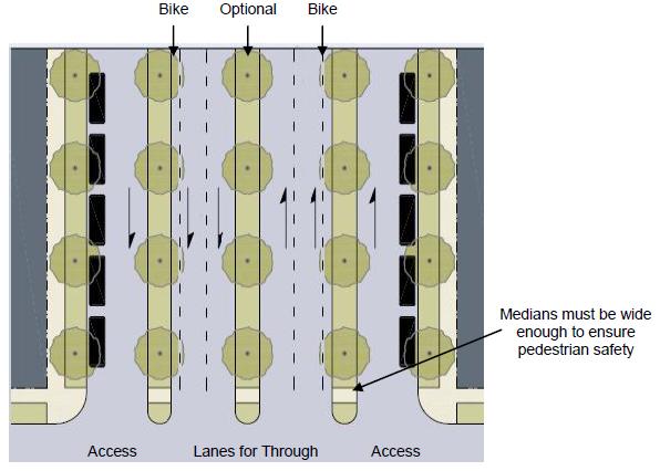
(Ord. 2017-22, Rep&ReEn, 07/05/2017)
13-10-012-0002 Bicycle Facilities in Traditional Neighborhoods
Thoroughfares in traditional neighborhoods are designed as "complete streets," i.e., based on the surrounding land use or transect zone first, and then on the speed of vehicles and the character of the thoroughfare second. As a result, accommodations for surrounding land uses, pedestrians, bicycles and vehicles can be provided to ensure maximum functionality of the thoroughfare and safety for all users.
A. Street design practices for conventional suburban developments may not be integrated with thoroughfare design concepts in traditional neighborhoods.
B. In transect zones T4 and T5, design features such as narrower travel lanes, street trees, wide sidewalks to accommodate mixed land uses such as restaurants, retail stores, offices, and residences on higher floors, careful building placement are necessary to create a well-defined outdoor room, and on-street parking.
C. For bike lanes in transect zones T4 and T5 (exclusive of multi-modal corridors and bikeway corridors), see Table 13-10-012-01.
D. In transect zones T1, T2, and T3 (as shown in Table 13-10-012-01), bike lanes may be provided based on vehicular speed in the thoroughfare, and on the uphill side of thoroughfares where grades exceed seven percent (7%).
E. When a free or speed thoroughfare is proposed in a traditional neighborhood district and the Regional Plan indicates that a multi-modal corridor or bikeway corridor is required within or adjacent to the traditional neighborhood district, accommodations for bicycle facilities must be provided in the thoroughfare design. This determines what bicycle facilities are required to ensure the connectivity of the multi-modal and bikeway corridors within the City. The City Engineer, or designee, shall have approval authority over appropriateness and fit of design selection. When a boulevard is proposed as described in Section 13-10-012-0001.5, a bike lane is to be incorporated into the thoroughfare section as shown in Figure 13-10-012-01. The following factors will be taken into consideration when deciding the most appropriate type of bicycle facility:
1. Intensity of activity and use anticipated within the transect zone and its associated land uses. For example, when there is a high intensity of pedestrian activity as a result of the mix of land uses adjacent to the thoroughfare, the thoroughfare should be designed and appropriate signage posted to provide for the shared use of the vehicle lane by cyclists, and bike lanes should not be provided.
2. Volume of through traffic projected for the multi-modal corridor.
When the volume of traffic on a thoroughfare increases, there may be a greater need for bicycle facilities to ensure the safety of cyclists.
3. As speed increases in a multi-modal corridor, the need for bicycle facilities also increases. This relationship is reflected in Table 13-10-012-01.
4. The layout of existing and proposed thoroughfares is used to determine if alternate routes for bicycles can be established that provide an equivalent level of connectivity and directness.
5. The development review process may result in other measures necessary to ensure that the thoroughfare design conforms to guidelines provided in the Regional Plan, that it maintains its integrity as a walkable environment based on the transect zone within which it is located, and that it provides a safe and convenient environment for all modes of travel. (Ord. 2017-22, Rep&ReEn, 07/05/2017)
13-10-012-0003 Special Districts
The standards and regulations for the design of thoroughfares in special districts as defined in Title 10, Flagstaff Zoning Code, shall be established by the City staff in consultation with the developer for final approval by the City Council. City staff shall base their decision on the proposed use(s) in the special district as well as the anticipated character of vehicle and pedestrian traffic. These standards and regulations shall be included in the form-based code and regulating plan associated with the proposed traditional neighborhood district. (Ord. 2017-22, Rep&ReEn, 07/05/2017)
13-10-012-0004 Tables: Thoroughfare Standards in Traditional Neighborhood Districts
The following tables provide standards and regulations for the application and design of thoroughfares in traditional neighborhood districts:
A. Table 13-10-012-01 – Vehicular/Parking/Right-of-Way Assemblies.
B. Vehicular Lane Assemblies (located in Title 10, Flagstaff Zoning Code).
C. Thoroughfare Assemblies (located in Title 10, Flagstaff Zoning Code).
D. Public Frontages – General (located in Title 10, Flagstaff Zoning Code).
E. Public Frontages – Specific (located in Title 10, Flagstaff Zoning Code).
F. Public Lighting (located in Title 10, Flagstaff Zoning Code).
G. Public Planting (located in Title 10, Flagstaff Zoning Code). (Ord. 2017-22, Rep&ReEn, 07/05/2017)
13-10-012-0005 Utilities in Traditional Neighborhood Districts
13-10-012-0005.1 Utility Placement in Thoroughfares in Traditional Neighborhood Developments
A. Generally water, sewer and stormwater facilities shall be placed under the street pavement. Where possible, water shall be ten (10) feet north or east of centerline and sewer on the centerline.
B. Electric, telephone, cable and gas utilities ("dry" utilities) shall be located in alleys or lanes where these are provided to minimize above-ground utility meters and boxes in the front of the property.
1. Design of the utilities must be completed prior to the approval of the public improvement plans and the final plat. This is necessary so that public utility easements (PUEs) that accommodate phone and cable pedestals, transformers, switching cabinets, and other elements are shown in both documents.
C. The typical location of utilities is illustrated in Engineering Details 9-01-010 and 9-01-011.
D. Regardless of whether utilities are located in the thoroughfare, the right-of-way adjacent to the thoroughfare, a utility easement, or a combination of these, utility access locations shall be provided. Ideally utilities shall be placed under the street (vehicle lanes) within the thoroughfare. Where this is not practical, utility access easements shall be required. (Ord. 2017-22, Rep&ReEn, 07/05/2017)
13-10-012-0005.2 Planning of Utilities in Traditional Neighborhood Developments
Franchise utility plans are to be developed to a level that takes into consideration the location of public utility easements in alleys, lanes, and other thoroughfares so that required equipment such as transformers, switching cabinets, among others, are accommodated on the construction plans and final plat. (Ord. 2017-22, Rep&ReEn, 07/05/2017)
13-10-012-0006 Vehicular Parking/Right-of–Way Assemblies
A "Thoroughfare Selection Report" shall be prepared for all new developments subject to the provisions of Section 10-60.10.080, and submitted to the City Traffic Engineer for review and approval. The thoroughfare selection report may be included in a required traffic impact analysis or traffic impact study. The thoroughfare selection report shall demonstrate what criteria or rationale was used for selecting thoroughfare types. See Table 13-10-012-01 below.
|
This table is provided to assist designers and reviewers in selecting appropriate design specifications for thoroughfares in traditional neighborhood districts. |
|||||||
|---|---|---|---|---|---|---|---|
|
T1 and T2 Movement Type |
SPEED |
TRAVEL Lane |
BIKE Lane |
PARKING |
EDGE |
PARKWAY |
PATH |
|
SLOW |
20 mph |
10' |
|
|
R |
5'-10' |
8'-10' |
|
FREE |
25 mph |
10' |
|
|
R or C |
5'-10' |
8'-10' |
|
SPEED |
30 mph |
10' |
Required |
|
R or C |
5'-10' |
8'-10' |
|
RURAL |
35 mph |
11' |
Required |
|
R or C |
5'-10' |
8'-10' |
|
T3 Movement Type |
SPEED |
TRAVEL Lane |
BIKE Lane |
PARKING |
EDGE |
PARKWAY |
PATH |
|
(Lots > 1 acre) |
20 mph |
10' |
|
|
R or C |
5'-10' |
5' min. |
|
SLOW |
20 mph |
9' |
|
6.5' |
C |
5'-10' |
5' min. |
|
FREE |
25 mph |
10' |
|
6.5' |
C |
5'-10' |
5' min. |
|
SPEED |
30 mph |
10' |
Required |
6.5' |
C |
5'-10' |
5' min. |
|
REAR LANE |
n/a |
12' |
|
|
|
4' |
n/a |
|
T4 Movement Type |
SPEED |
TRAVEL Lane |
BIKE Lane |
PARKING |
EDGE |
PARKWAY |
PATH |
|
SLOW |
20 mph |
11' |
|
6.5' |
C |
5' min. |
6' min. |
|
SLOW (w/45° parking) |
20 mph |
12' |
|
18.5' |
C |
7' min. |
6' min. |
|
FREE |
25 mph |
11' |
S |
6.5' |
C |
5' min. |
6' min. |
|
FREE (w/45° parking) |
25 mph |
12' |
|
18.5' |
C |
7' min. |
6' min. |
|
SPEED |
30 mph |
11' |
S |
6.5' |
C |
5' min. |
6' min. |
|
ALLEY |
n/a |
21' |
|
|
Ribbon |
|
|
|
T5 and T6 Movement Type |
SPEED |
TRAVEL Lane |
BIKE Lane |
PARKING |
EDGE |
PARKWAY |
PATH |
|
SLOW |
20 mph |
11' |
|
6.5' |
C |
5' min. |
8' min. |
|
SLOW (w/45° parking) |
20 mph |
12' |
|
18.5' |
C |
5'-7' |
8' min. |
|
FREE |
25 mph |
11' |
S |
6.5' |
C |
5' min. |
8' min. |
|
FREE (w/45° parking) |
25 mph |
12' |
|
18.5' |
C |
5'-7' |
8' min. |
|
SPEED |
30 mph |
11' |
S |
6.5' |
C |
5' min. |
8' min. |
|
ALLEY |
n/a |
21' |
|
|
Ribbon |
|
|
|
Curb Radius (assumes 90 degree intersections) |
|||||||
|
MOVEMENT TYPE |
SPEED |
Curb Radius w/Parking |
R = Rural edge treatment |
||||
|
SLOW |
20 mph |
5'-10' |
C = Curb edge treatment |
||||
|
FREE |
25 mph |
10'-15' |
Ribbon = Ribbon Curb (18 inches) |
||||
|
SPEED |
30 mph |
15'-20' |
S = When authorized by staff |
||||
|
RURAL |
35 mph |
25' |
|
||||
TABLE 13-10-012-01 NOTES:
1. Parking lanes are measured from the edge of pavement to the edge of the adjacent travel lane.
2. Bike lanes shall be four (4) feet for rural edge streets, four and one-half (4-1/2) feet for curbed streets, and five (5) feet when adjacent to a striped parking lane. Where cyclists share a travel lane with a car, shared lane marking for bicycles and vehicles may be provided. Also, refer to Section 13-10-012-0002. Bike lanes may also be required where uphill grades exceed seven percent (7%) or to provide continuity between neighborhoods. Where a bike lane is provided adjacent to a path, the path width may be reduced to five (5) feet.
3. Right-of way shall be located two (2) feet from back of sidewalk or at the back of sidewalk when adjacent to buildings.
4. Arterial and major collector roads, as identified in Division 13-10-014, shall be designed as boulevards (see Section 13-10-012-0001.5).
5. Thoroughfares shall be designed according to the type of vehicle expected to use each thoroughfare on a daily basis recognizing that occasionally, large vehicles may cross the centerline when making turning movements.
(Ord. 2017-22, Rep&ReEn, 07/05/2017)