


Chapter 9.24
Residential Zoning Districts
Sections:
9.24.020 - Purposes of the Residential Zoning Districts
9.24.030 - Residential District Allowable Land Uses
9.24.040 - Residential District Parcel and Density Standards
9.24.050 - Residential District Site Planning and Building Standards
9.24.060 - Residential District Land Use Limitations
9.24.070 - Residential Special Considerations
9.24.010 Purpose
This Chapter lists the land uses that may be allowed within the residential zoning districts established by Section 9.12.020 (Zoning Map and Zoning Districts), determines the type of planning permit/approval required for each use, and provides basic standards for site layout and building size.
9.24.020 Purposes of the Residential Zoning Districts
The purposes of the individual residential zoning districts and the manner in which they are applied are as follows.
A. RVL (Residential - Very Low Density) district. The RVL zoning district is applied to areas where physical constraints, the protection of natural features, or the preservation of semi-rural character have been identified by the General Plan as important considerations. The RVL zoning district is primarily applied to areas with steep slopes, and where the General Plan intends that the open space character of the City’s hillsides and perimeter lands are to be preserved. Individual homesites are allowed in hillside areas, as long as precautions are taken to prevent the excessive removal of vegetation, and strict grading controls are enforced to prevent erosion (see Chapter 9.52 for hillside development standards). The allowable density is two or fewer primary dwellings per acre. The RVL zoning district is consistent with and implements the Residential - Very Low Density land use classification of the General Plan.
B. RL (Residential - Low Density) district. The RL zoning district is applied to areas appropriate for neighborhoods of single-family homes on individual lots, and related, compatible uses. The allowable density ranges from two to 7.25 dwellings per acre. The RL zoning district is consistent with and implements the Residential - Low Density land use classification of the General Plan.
C. RM (Residential - Medium Density) district. The RM zoning district is applied to areas appropriate for a variety of housing types, including small-lot single-family housing, and various types of multifamily housing (for example, duplexes, townhouses, and apartments). The allowable density ranges from 7.26 to 15 dwellings per acre. The RM zoning district is consistent with and implements the Residential - Medium land use classification of the General Plan.
D. RH (Residential - High Density) district. The RH zoning district is applied to areas appropriate for various types of multi-family housing, including duplexes, townhouses, and apartments. The allowable density ranges from 15.01 to 32 units per acre. The RH zoning district is consistent with and implements the Residential - High Density land use classification of the General Plan.
9.24.030 Residential District Allowable Land Uses
Table 2-4 identifies the uses of land allowed by this Land Use Code in each residential zoning district, and the planning permit required to establish each use, in compliance with Section 9.20.030 (Allowable Land Uses and Permit Requirements).
Note: Where the last column in the table ("Specific Use Regulations") includes a section number, the regulations in the referenced section apply to the use. Provisions in other sections of this Land Use Code may also apply.
|
TABLE 2-4 Allowed Land Uses and Permit Requirements for Residential Zoning Districts |
P MUP UP S — |
Permitted Use, Zoning Clearance required Minor Use Permit required Use Permit required Permit determined by specific use regulations Use not allowed |
||||
|---|---|---|---|---|---|---|
|
LAND USE (1) |
PERMIT REQUIRED BY DISTRICT |
Specific Use Regulations |
||||
|
RVL |
RL |
RM |
RH |
|||
|
AGRICULTURAL & OPEN SPACE USES |
||||||
|
Agricultural accessory structure |
MUP |
UP |
UP |
UP |
||
|
Agricultural cultivation - Cannabis |
— |
— |
— |
— |
||
|
Animal keeping |
S |
S |
S |
S |
||
|
Crop production, horticulture, orchard, vineyard |
MUP |
MUP |
MUP |
MUP |
|
|
|
Greenhouse and nursery structures, 300 sf or less |
UP |
UP |
— |
— |
|
|
|
Greenhouse and nursery structures, larger than 300 sf |
— |
— |
— |
— |
|
|
|
Produce stand, 1,000 sf maximum |
MUP |
MUP |
MUP |
MUP |
9.42.140.F |
|
|
RECREATION, EDUCATION & PUBLIC ASSEMBLY USES |
||||||
|
Equestrian facility |
UP |
— |
— |
— |
||
|
Meeting facility, public or private |
MUP |
MUP |
MUP |
MUP |
|
|
|
Parks and playgrounds, public |
P |
P |
P |
P |
|
|
|
Private residential recreation facility |
— |
MUP |
MUP |
MUP |
|
|
|
School - Public or private, elementary or secondary |
MUP |
MUP |
MUP |
MUP |
|
|
|
RESIDENTIAL USES |
||||||
|
Home occupation |
P |
P |
P |
P |
||
|
Mobile home - Outside of mobile home park |
P |
P |
P |
P |
||
|
Mobile home park, including individual mobile homes |
UP |
UP |
UP |
UP |
||
|
Multi-family housing, 2 units |
— |
P |
P |
P |
|
|
|
Multi-family housing, 3 to 9 units |
— |
MUP(2) |
P |
P |
||
|
Multi-family housing, 10 or more units |
— |
— |
P |
P |
||
|
Organizational house (sorority, monastery, religious, etc.) |
UP |
UP |
UP |
UP |
|
|
|
Residential accessory use or structure |
P |
P |
P |
P |
||
|
Residential care facility, 6 or fewer clients |
P |
P |
P |
P |
|
|
|
Residential care facility, 7 or more clients |
UP |
UP |
UP |
UP |
|
|
|
Rooming or boarding house |
— |
UP |
P |
P |
|
|
|
Second unit |
P |
P |
P |
P |
||
|
Single-family dwelling |
P |
P |
P |
P |
|
|
|
RETAIL TRADE |
||||||
|
Accessory retail |
UP |
UP |
P |
P |
||
|
Convenience store |
UP |
UP |
UP |
UP |
|
|
|
SERVICES |
||||||
|
Accessory services |
UP |
UP |
P |
P |
||
|
Adult/child day care center |
P(3) |
P(3) |
P(3) |
P(3) |
||
|
P |
P |
P |
P |
|||
|
Group quarters |
UP |
UP |
UP |
UP |
|
|
|
Lodging - Bed and breakfast inn (B&B), 5 or fewer rooms |
P |
P |
P |
P |
||
|
Lodging - Bed and breakfast inn (B&B), 6 or more rooms |
MUP |
MUP |
MUP |
MUP |
||
|
Lodging - Hostel |
MUP |
MUP |
MUP |
MUP |
|
|
|
Medical services - Extended care |
MUP |
MUP |
MUP |
MUP |
|
|
|
Mobile maintenance services |
S |
S |
S |
S |
||
|
TRANSPORTATION, COMMUNICATIONS & INFRASTRUCTURE |
||||||
|
Pipeline, utility transmission or distribution line |
UP |
UP |
UP |
UP |
|
|
|
Utility facility |
UP |
UP |
UP |
UP |
|
|
|
Utility infrastructure |
P |
P |
P |
P |
|
|
|
Windmill for electricity generation |
MUP |
UP |
UP |
UP |
||
|
Key to Zoning District Symbols |
||||||
|
RVL |
Residential - Very Low Density |
RM |
Residential - Medium Density |
|||
|
RL |
Residential - Low Density |
RH |
Residential - High Density |
|||
|
Notes: (1) See Article 10 (Glossary) for land use definitions. (2) Allowed only in compliance with Section 9.24.060.B (RL Alternative Development Option). (3) Principally permitted if the standards of Section 9.42.070 are met; otherwise a Minor Use Permit (MUP) is required. |
||||||
(Ord. 1382, eff. 12/22/2008; Ord. 1392, eff. 5/15/2009; Ord. 1419, eff. 10/5/2012; Ord. 1435, eff. 12/6/2013; Ord. 1496, eff. 12/20/2017)
9.24.040 Residential District Parcel and Density Standards
A new subdivision, and the density of residential development, shall comply with the requirements shown in Table 2-5.
|
Development Standard |
Requirement by Zoning District |
|||
|---|---|---|---|---|
|
RVL |
RL |
RM |
RH |
|
|
Minimum lot area |
20,000 sf |
4,000 sf, 6,000 sf average (1)(2) |
3,000 sf |
6,000 sf |
|
Minimum lot width |
60 ft (3) |
60 ft (3) |
30 ft (4) |
30 ft (4) |
|
Maximum lot depth |
4 times lot width (2) |
None |
None |
None |
|
Residential density |
2 or fewer primary units per acre, maximum (5) |
2 minimum to 7.25 units maximum per acre (5) |
7.26 minimum to 15 units maximum per acre (5) |
15.01 minimum to 32 units maximum per acre (5) |
|
Plus 1 second unit per parcel in compliance with Section 9.42.030 |
||||
Notes:
(1) A parcel in a new subdivision may be as small as 4,000 square feet, but the average size of all the parcels must be 6,000 square feet, except where the subdivision complies with the Special Subdivision Design Standards of Section 9.88.032.
(2) Section 9.24.060.B (RL Alternative Development Option) may allow a lower average.
(3) May be reduced to 30 feet where the review authority determines that a lesser proposed width is sufficient to ensure safe and adequate access and parking.
(4) A larger minimum width may be required where the review authority determines that 30 feet is insufficient to ensure safe and adequate access and parking.
(5) See Section 9.31.030 for Density Bonus Provisions.
(Ord. 1419, eff. 10/5/2012)
9.24.050 Residential District Site Planning and Building Standards
New land uses and structures, and alterations to existing land uses and structures, shall be designed, constructed, and established in compliance with the requirements in Tables 2-6 through 2-9, in addition to the applicable standards (e.g., landscaping, parking and loading, etc.) in Article 3 of this Land Use Code.
|
Development Standard |
RVL Zone Requirement |
|
|---|---|---|
|
Code |
Density Bonus |
|
|
|
||
|
Setbacks - Minimum and, where noted, maximum setbacks required. See Section 9.30.090 for exceptions to these requirements. See Figure 2-1. |
||
|
Front |
10 ft |
N/A |
|
Side - Interior (each) |
5 ft |
N/A |
|
Side - Street side |
10 ft |
N/A |
|
Rear |
5 ft |
N/A |
|
Garage - Front |
20 ft |
N/A |
|
Accessory structures |
See 9.42.030 (Accessory Structures) |
|
|
Streamside setbacks |
See Chapter 9.59 |
|
|
|
||
|
Floor area ratio (FAR) -Maximum allowable FAR. See the definition and illustration of FAR in Article 10 (Glossary) |
||
|
Maximum FAR |
0.20 |
N/A |
|
|
||
|
Maximum site coverage -Maximum percentage of site area to be occupied by structures, parking, driveways, and pavement. |
||
|
Maximum coverage |
20% |
N/A |
|
|
||
|
Height limit -Maximum allowable height of structures. See Section 9.30.040 (Height Limits and Exceptions) for height measurement requirements, and height limit exceptions. See Figure 2-2. |
||
|
Maximum height |
35 ft. |
37 ft |
|
|
||
|
Landscaping - See Chapter 9.34 (Landscaping) |
||
|
Parking - See Chapter 9.36 (Parking and Loading) |
||
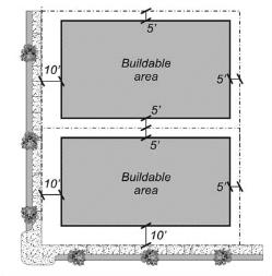
Figure 2-1 - Setback Requirements
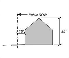
Figure 2-2 - Building Height and Profile
|
Development Standard |
RL Zone Requirement |
|
|---|---|---|
|
Code |
Density Bonus |
|
|
|
||
|
Setbacks - Minimum and, where noted, maximum setbacks required. See Section 9.30.090 for exceptions to these requirements. See Figure 2-3. |
||
|
Front |
10 ft |
8 ft |
|
Side - Interior (each) |
5 ft |
0 ft |
|
(townhouse and condo) |
|
|
|
Side - Street side |
10 ft |
8 ft |
|
Rear |
5 ft |
N/A |
|
Garage - Front |
20 ft |
N/A |
|
Accessory structures |
See 9.42.030 (Accessory Structures) |
|
|
Streamside setbacks |
See Chapter 9.59 |
|
|
|
||
|
Floor area ratio (FAR) -Maximum allowable FAR. See the definition and illustration of FAR in Article 10 (Glossary) |
||
|
Maximum FAR |
0.50 |
N/A |
|
|
||
|
Maximum site coverage -Maximum percentage of site area to be occupied by structures, parking, driveways, and pavement. |
||
|
Maximum coverage |
50% |
|
|
|
||
|
Height limit -Maximum allowable height of structures. See Section 9.30.040 (Height Limits and Exceptions) for height measurement requirements, and height limit exceptions. See Figure 2-4. |
||
|
Maximum height |
35 ft. |
38 ft |
|
|
||
|
Landscaping - See Chapter 9.34 (Landscaping) |
||
|
Parking - See Chapter 9.36 (Parking and Loading) |
||
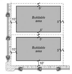
Figure 2-3 - Setback Requirements
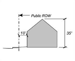
Figure 2-4 - Building Height and Profile
|
Development Standard |
RM Zone Requirement |
|
|---|---|---|
|
Code |
Density Bonus |
|
|
|
||
|
Setbacks - Minimum and, where noted, maximum setbacks required. See Section 9.30.090 for exceptions to these requirements. See Figure 2-5. |
||
|
Front |
10 ft |
5 ft |
|
Side - Interior (each) |
5 ft |
0 ft |
|
(townhouse and condo) |
|
|
|
Side - Street side |
10 ft |
5 ft |
|
Rear |
5 ft |
N/A |
|
Garage - Front |
20 ft |
N/A |
|
Accessory structures |
See 9.42.030 (Accessory Structures) |
|
|
Streamside setbacks |
See Chapter 9.59 |
|
|
|
||
|
Maximum site coverage -Maximum percentage of site area to be occupied by structures, parking, driveways, and pavement. |
||
|
Maximum coverage |
60% |
|
|
|
||
|
Height limit -Maximum allowable height of structures. See Section 9.30.040 (Height Limits and Exceptions) for height measurement requirements, and height limit exceptions. See Figure 2-6. |
||
|
Maximum height |
35 ft. |
38 ft |
|
|
||
|
Landscaping - See Chapter 9.34 (Landscaping) |
||
|
Parking - See Chapter 9.36 (Parking and Loading) |
||

Figure 2-5 - Setback Requirements
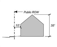
Figure 2-6 - Building Height and Profile
|
Development Standard |
RH Zone Requirement |
|
|---|---|---|
|
Code |
Density Bonus |
|
|
|
||
|
Setbacks - Minimum and, where noted, maximum setbacks required. See Section 9.30.090 for exceptions to these requirements. See Figure 2-7. |
||
|
Front |
10 ft |
5 ft |
|
Side - Interior (each) |
5 ft |
N/A |
|
Side - Street side |
10 ft |
5 ft |
|
Rear |
5 ft |
N/A |
|
Garage - Front |
20 ft |
N/A |
|
Accessory structures |
See 9.42.030 (Accessory Structures) |
|
|
Streamside setbacks |
See Chapter 9.59 |
|
|
|
||
|
Maximum site coverage -Maximum percentage of site area to be occupied by structures, parking, driveways, and pavement. |
||
|
Maximum coverage |
70% |
N/A |
|
|
||
|
Height limit -Maximum allowable height of structures. See Section 9.30.040 (Height Limits and Exceptions) for height measurement requirements, and height limit exceptions. See Figure 2-8. |
||
|
Maximum height |
35 ft. |
45 ft |
|
|
||
|
Landscaping - See Chapter 9.34 (Landscaping) |
||
|
Parking - See Chapter 9.36 (Parking and Loading) |
||
Figure 2-7 - Setback Requirements
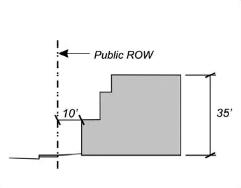
Figure 2-8 - Building Height and Profile
9.24.060 Residential District Land Use Limitations
A. RVL district performance standards.
1. Grading. All grading shall be strictly controlled to prevent the excessive removal of natural vegetation, and erosion. Development and grading on slopes greater than 15 percent may be allowed only with Hillside Development Permit approval.
2. Seismic and geologic hazards. The review authority shall ensure that each development proposal on a sloping site is designed to avoid or mitigate seismic and geologic hazards.
B. RL district alternative development option. An applicant for a development project within the RL zoning district on a site of less than one-half acre may choose to comply with the following standards instead of the other equivalent applicable standards of this Chapter.
1. Permit requirement. Minor Use Permit approval shall be required for a project with multiple uses, and/or with a use that would otherwise require Use Permit approval.
2. Development standards. A residential project of three or more dwelling units shall comply with the following standards:
a. Reserved occupancy. At least one unit shall be reserved for occupancy by a low income household; this reservation shall remain in place for a minimum of 15 years
b. Maximum density. Density shall not exceed one unit for every 3,000 square feet of the overall development area, regardless of the size of the units. No additional density bonus shall be provided. The units may be constructed in a single building or in any combination of separate buildings; and on a single lot, or result in multiple lots.
c. Subdivision process. A subdivision in compliance with this Subsection shall also comply with Article 8 (Subdivision Regulations and Procedures), provided that a public hearing is not required unless new lots are created.
d. Floor area ratio. Total project floor area ratio (FAR) shall not apply to an alternative development option.
e. Site and building standards. Project setbacks, site coverage and the height of structures shall comply with the requirements of the RL zoning district, provided that the review authority may reduce setback and increase site coverage requirements where the review authority finds that safe and adequate access and parking will be provided.
f. Parking. Off-street parking shall comply with the requirements of Chapter 9.36 (Parking and Loading), provided that at least one space per unit shall be provided.
3. Further subdivision. A development approved in compliance with this Subsection shall not subsequently be further subdivided unless each new parcel complies with all the minimum lot area standards of the RL zoning district.
C. Planned residential development requirements. As required by General Plan Policy LU-2d, the development of a vacant site of one acre and larger shall require that the Planned Development combining zone first be applied to the property. The purpose shall be to: incorporate a mix of residential types, unit sizes, and styles in a coordinated manner to allow clustering of units; to provide larger, more usable areas not affected by site coverage; and to protect natural resources or site features, including creekside riparian areas, wetlands, and significant vegetation such as trees. Where a planned residential development is adjacent to a non-residential use, appropriate visual and noise buffers shall be provided between the uses. Other provisions within a Plan Development should also address affordable housing.
9.24.070 Residential Special Considerations
Proposed development and new land uses on parcels within the SCR (Special Considerations - Residential) combining zone shall comply with the following requirements, as applicable, in compliance with General Plan Table LU-3.
|
SCR Zone |
Area |
SCR Zone Requirements |
|---|---|---|
|
1 |
Spear Av. & St. Louis Rd. |
Residential development shall include a mix of housing types and shall be clustered to maintain stream course and riparian areas as open space. |
|
2 |
Sunset at Baldwin APN’s 505-121-026 |
Residential development shall be clustered to preserve Jolly Giant Creek watercourse and wetland areas as open space, and to reserve right-of-way for the future extension of Foster Avenue to Sunset Avenue. Access to residential development should be from Foster. The City shall allow an alternative unit density as approved through a Type A planned development permit for a maximum of 143 one-bedroom and/or efficiency units. Density bonus shall not apply to this alternative development option. [Twin Parks property] |
|
3 |
North of Wiyot Way & south of Mustang Lane |
On APN 507-291-032, north of Wiyot Way, a residential special consideration shall be placed on this site that would allow for development of hospital related housing, including, but not limited to: life care facilities, assisted living facilities, medical related group quarters, medical services - extended care facilities, temporary housing for family members of hospital patients, or housing for doctors, nurses, and hospital staff per PC Resolution 08-11. |
|
4 |
Shirley Blvd., Park Ave., Park Place Annexation (Portion) APN’s 503-092-003, 503-103-008, 503-103-019, 503-103-023, 503-104-001, 503-104-002, 503-104-003, 503-104-004, and 503-104-011 |
These assessor parcels are substandard in size and do not meet the 20,000 s.f. minimum parcel size required by the RVL zoning district. The :SCR applied to these parcels will allow the continued nonconformity pertaining to parcel size without further action on the part of the property owner(s) per PC Resolution 13-01. |
(Ord. 1398, eff. 1/15/2010; Ord. 1429, eff. 1/15/2014; Ord. 1448, eff. 10/31/2014)