


Chapter 3-05
GENERAL PROVISIONS
Sections:
3-05-010 Nonconforming structures and buildings.
3-05-020 Nonconforming uses.
3-05-030 Development standards related to the seismic hazard mitigation program.
3-05-040 Required lot area.
3-05-050 Nonconforming lots of record.
3-05-060 Special lot requirements.
3-05-070 Lot frontage required.
3-05-080 Calculation of residential units.
3-05-090 Density bonuses for affordable and senior housing.
3-05-100 Yards – Generally.
3-05-110 Yards – Front.
3-05-120 Side yards.
3-05-130 Projection into street frontage yards.
3-05-140 Projection into non-street frontage yards.
3-05-150 Accessory structures.
3-05-160 Dwelling groups.
3-05-170 Buildings in rear of main buildings.
3-05-180 Accessory structures and uses.
3-05-190 Fences.
3-05-200 Signs.
3-05-210 Repealed.
3-05-220 Landscaping materials.
3-05-230 Swimming pools.
3-05-240 Reserved.
3-05-250 Interstate 580 plan lines.
3-05-260 Creation of special building lines.
3-05-270 Heights of buildings and structures.
3-05-280 Sloping lot height measurement.
3-05-290 Exceptions to height limitations.
3-05-300 Grading activities.
3-05-310 Public utility undergrounding.
3-05-320 Mechanical equipment screening.
3-05-010 Nonconforming structures and buildings.
A. No nonconforming structure or building shall be altered or reconstructed so as to increase the discrepancy between existing conditions and the development standards prescribed in the regulations for the district in which the structure or building is located.
B. No nonconforming structure or building shall be moved or enlarged unless the new location or enlargement shall conform to the current development standards for the district in which the structure or building is located.
C. A nonconforming structure or building which is partially destroyed due to accidental damage may be restored and the existing use resumed; provided, the accidental destruction does not exceed 50 percent of the structure. Reconstruction of the damaged structure must begin within one year and be completed within two years thereafter.
D. Whenever more than 50 percent of a nonconforming structure or building is destroyed due to accidental damage, or is voluntarily razed, the structure shall not be restored except in full conformity with the regulations for the district in which it is located, and any nonconforming use shall not be resumed. This limitation shall not apply if doing so would decrease the number of low-income rental housing units available in this city. Review of nonconforming structures shall be conducted by the zoning administrator. Any person aggrieved by a decision of the zoning administrator in the administration or enforcement of this section may appeal the decision in accordance with the procedures set forth in Chapter 5-15 LPZC.
E. The extent, or percentage, of damage or partial destruction shall be based upon the ratio of the estimated cost of restoring the structure to its condition prior to such damage or partial destruction, to the estimated cost of duplicating the entire structure, as it existed prior to such damage or partial destruction. (Ord. 1758 § 4, 2005)
3-05-020 Nonconforming uses.
A. A use lawfully occupying a structure or a site at the time of the adoption of this code or any amendment thereto and which does not conform with the use regulations of the district in which it is located shall be deemed to be a nonconforming use and may be continued, except as otherwise provided in this chapter.
B. A nonconforming use within a single-tenant building may only be replaced by a conforming use or another nonconforming use that is the same as or similar to the previous nonconforming use, provided not more than six months have passed since the cessation of the previous nonconforming use, and provided the replacement nonconforming use does not create new impacts or an increase in intensity of the land use.
C. A nonconforming use within a multi-tenant building may be replaced by a conforming use, a nonconforming use that is the same as or similar to the previous nonconforming use within the tenant space, provided not more than six months has passed since the cessation of the previous nonconforming use, or by a nonconforming use that is the same as or similar to an existing nonconforming use within the building, provided the replacement nonconforming use does not create new impacts or an increase in intensity of the land use.
D. Similar nonconforming uses, as discussed in subsections (B) and (C) of this section, shall fall within the same category of uses (e.g., personal services or offices) permitted under the provisions of the previous zoning district in which the use was lawfully permitted and located.
E. Review of new nonconforming uses shall be conducted by the zoning administrator. Any person aggrieved by a decision of the zoning administrator in the administration or enforcement of this section may appeal the decision in accordance with the procedures set forth in Chapter 5-15 LPZC.
F. No nonconforming use shall be enlarged or extended in such a way as to occupy any part of a structure or site which was not previously occupied by the same or similar nonconforming use on the effective date of the ordinance codified in this chapter, or of any amendment thereto, that caused it to become a nonconforming use, or in any way displace any conforming use occupying a structure or site, except as permitted in this section.
G. A structure containing a nonconforming use may be expanded so long as the new addition is occupied by a conforming use, and the conforming use does not directly facilitate or support the non-conforming use. The new addition is subject to the development standards of the underlying zoning district. Both the existing building and new addition must comply with currently adopted city design guidelines.
H. Whenever all nonconforming uses on a site have been abandoned, discontinued, or changed to a conforming use for a continuous period of six months or more, the nonconforming use shall not be reestablished, and the use of the structure or site thereafter shall be in conformity with the regulations for the district in which it is located. Abandonment or discontinuance shall include cessation of a use regardless of intent to resume the use. This restriction shall not apply if doing so would decrease the number of low-income rental housing units available in the city.
I. All nonconforming uses of land not involving any building or structure, except minor structures and buildings having an assessed value for tax purposes of $10,000 or less, may be continued for a period of three years after the date of enactment of the ordinance codified in this chapter, at the end of which period such nonconforming use shall cease or shall be changed to a conforming use, unless a conditional use permit has been issued for such use. (Ord. 1758 § 5, 2005)
3-05-030 Development standards related to the seismic hazard mitigation program.
A. For buildings within the DSP zoning district, subject to approval of a site plan approval as described in subsection (C) of this section:
1. Preservation, Reinforcement or Additions. For projects, listed in either the 2003 downtown specific plan historic resources inventory (with a rating of one to five) or under the provisions of the city’s seismic hazard mitigation program, that preserve, reinforce and add to an existing structure, the requirements for parking shall be completely waived subject to the following requirements and findings:
a. There is no significant visual deterioration of the historic features of the structure;
b. All provisions of the downtown specific plan are met; and
c. In the case of additions to historic structures, the new addition does not negatively impact the historic nature of the structure.
2. Replacement of an Historic Building. If an historic building, listed only under the provisions of the city’s seismic hazard mitigation program, is replaced with one that is exactly the same size and style, it shall be permitted to continue any nonconforming lack of parking that it previously had. That is, no new parking spaces would be required; however, all existing spaces must remain. In the case where an addition was being planned, only one-half of the required parking would need to be provided for the additional square footage. Property owners who chose to replace their buildings without meeting these provisions would need to meet all of the required parking requirements for the new building.
B. For buildings in all city zoning districts except the DSP zoning district, subject to approval of a site plan approval as described in subsection (C) of this section:
1. For projects that preserve, reinforce (and add to) an existing structure under the provisions of the city’s seismic hazard mitigation program, permitted coverage or floor area ratios for the affected properties may be increased by up to 20 percent for additions to affected structures.
2. If an historic building is replaced with one that is exactly the same size and style, the approved replacement replica of the original building would be permitted to add square footage up to 10 percent over the maximum floor area ratio or coverage.
C. The provisions stated in subsections (A) and (B) of this section shall be administered by the zoning administrator with a site plan approval.
1. Applications requesting the incentives outlined in subsections (A) and (B) of this section shall be reviewed by the historic preservation commission and the planning commission, which will make recommendations to the zoning administrator.
2. For projects proposing to modify or replace an existing structure, the State Office of the Architect or a comparable expert shall review the proposal to give expert historical advice on the architecture of the project.
3. In order to grant the incentives listed in subsections (A) and (B) of this section, the zoning administrator (with recommendations from the planning commission and the historical preservation commission) must make the following findings:
a. The application is for a building listed on the city’s list of unreinforced masonry structures.
b. The building has significant aesthetic, cultural, or historic value to the city.
c. Repairs costing at least 25 percent of the value of the building are required for the building under the provisions of the city’s seismic hazard mitigation ordinance.
d. The proposed addition or replacement visually preserves the historical aspects of the structure.
e. The replacement structure accurately represents the most historically significant form of the demolished building. (This would generally be the earliest clearly defined facades that the structure supported.)
f. The proposed incentives that will be utilized will not significantly negatively impact adjacent properties. (Ord. 1861 § 1, 2009; Ord. 1709 § 7, 2004; Ord. 1363, 1991; Ord. 442 § 20.23)
3-05-040 Required lot area.
No lot, parcel, yard, court, parking area, or other space shall be reduced in area or dimension so as to make said area or dimension less than the minimum required by this code; and, if already less than the minimum required by this code, said area or dimension shall not be further reduced. (Ord. 442 § 20.31)
3-05-050 Nonconforming lots of record.
In any district where residential uses are permitted, a one-family detached dwelling may be erected on any lot of official record at the effective date of the ordinance codified in this chapter; provided, however, that no lot shall average less than 40 feet wide for the calculation of yard requirements, and the sum of the side yards shall not be less then 20 percent of the width of the lot; provided, however, that on a corner lot, the width of the side yard adjoining the street lot line shall not be less than eight feet or 20 percent of the frontage, whichever is the greater, and the depth of the rear yard of any such lot need not exceed 20 percent of the depth of the lot, but in no case shall it be less than 10 feet. (Ord. 442 § 20.32)
3-05-060 Special lot requirements.
A. In any district, other than an OS-A district, where neither public water supply nor public sanitary sewer is accessible, the otherwise specified lot area and frontage requirements, of less than the following, shall be:
1. Lot Area. One acre;
2. Lot Frontage at Building Line. One hundred and fifty feet;
B. Provided, however, that where a public water supply is available, these requirements shall be:
1. Lot Area. Twenty thousand square feet; and
2. Lot Frontage. One hundred feet, respectively. (Ord. 442 § 20.33)
3-05-070 Lot frontage required.
Lot frontage is as specified for the zoning district in which the lot is located. (Ord. 442 § 20.34)
3-05-080 Calculation of residential units.
The maximum number of dwelling units permitted in each residential project shall be calculated by multiplying the gross residential acreage of the project site, as defined by the general plan, times the maximum allowable density under the general plan residential land use designation and as adjusted by any variation permitted in the general plan. Where the number of units permitted results in a fraction, the number will be rounded down to the nearest whole number. (Ord. 1528, 1998; Ord. 442 § 20.35)
3-05-090 Density bonuses for affordable and senior housing.
A. Definitions. For the purpose of this section, the following terms shall be defined as follows:
1. “Affordable to low-income or very-low-income households” means that the sales prices or rental rates of a housing development conform with the current “City of Livermore Affordable Housing Sales Prices and Rental Rates,” established annually by resolution of the city council.
2. “Affordable housing project” means a residential development consisting of five or more units, not including any bonus units requested pursuant to this section, in which (a) at least 20 percent of the total units are affordable to low-income households, or (b) at least 10 percent of the total units are affordable to very-low-income households, or (c) at least 50 percent of the total units are senior housing (Government Code Section 65915(b) and Civil Code Sections 51.2 and 51.3).
3. “Community development director” means the community development director or his or her designee.
4. “Density bonus” means a density increase of at least 25 percent over the otherwise maximum allowable residential density under the applicable zoning ordinance and land use element of the general plan as of the date of application by the developer to the city (Government Code Section 65915(f)).
5. “Housing development” means one or more groups of projects for residential units constructed in the city.
6. “Density bonus housing agreement” means an agreement between the city and the developer setting forth the terms and conditions of the award of a density bonus, and which the city council finds is required to make an affordable housing project economically feasible (Government Code Section 65915(h)).
7. “Incentive” means a regulatory or financial concession, grant, refund, or waiver which reduces or avoids project costs.
8. “Restricted unit” means a unit which is affordable to very-low- or low-income households as defined in the housing element of the city of Livermore general plan and approved pursuant to this section.
9. “Senior housing” means housing developed for residents aged 62 years or older, or 55 years or older in a senior citizen housing development of 35 units or more (Civil Code Section 51.3(c)).
10. “Unit” means a residential lot for subdivision projects or a housing unit for nonsubdivision projects.
B. Density Bonus Entitlement. The city shall grant the developer of an affordable housing project either (1) a density bonus and at least one incentive unless the city makes a written finding that the additional incentive is not required in order to provide for affordable housing, or (2) provide other incentives of equivalent financial value based upon the land cost per dwelling unit (Government Code Section 65915(b)).
The following regulations apply only to the granting of a density bonus and one additional incentive:
1. The affordable housing project may be a sales or rental development, and may be a single-family or multifamily development.
2. The density bonus shall not be included when determining the number of housing units which is equal to 10 or 20 percent of the total.
3. The density bonus shall be permitted in geographic areas of the housing development other than the areas where the units for the lower-income households are located (Government Code Section 65915(g)).
4. The developer may request a density bonus exceeding 25 percent. The excess bonus units shall constitute an incentive apart from the 25 percent density bonus for a qualifying project.
5. A developer who requests a density bonus of less than 25 percent for a qualifying project will nevertheless be required to provide the minimum number of restricted units necessary to qualify as an affordable housing project.
6. A developer who agrees to construct both 20 percent low-income units and 10 percent very- low-income units shall be entitled to only one density bonus and at least one additional incentive, although the city may, at its discretion, grant more than one density bonus.
C. Incentives. Incentives may include, but are not limited to, the following:
1. A reduction in site development standards or a modification of zoning code requirements which exceed the minimum building standards set forth in Health and Safety Code Section 18901 et seq. and would otherwise inhibit the utilization of the density bonus on specific sites (Government Code Section 65915(h)). These may include, but are not limited to, any of the following:
a. Reduced minimum lot sizes or dimensions.
b. Reduced minimum lot setbacks.
c. Reduced minimum outdoor or private outdoor living area.
d. Increased maximum lot coverage.
e. Increased maximum building height or stories.
f. Reduced minimum building separation requirements.
g. Rezoning to planned development district.
2. Approval of mixed use zoning in conjunction with the housing project, if commercial, office, industrial, or other land uses will reduce the cost of the housing development and if the commercial, office, industrial, or other land uses are compatible with the housing project and the existing or planned development in the area where the proposed housing project will be located (Government Code Section 65915(h)).
3. Waiver of certain city fees applicable to the restricted units in an affordable housing project. Fees to be waived may be established by resolution of the city council on a project-by-project basis, which may be amended from time to time.
4. Pursuant to the city’s growth management program, in a competitive year, a project including between 35 percent and 50 percent of its units as very-low-income housing units will not be subject to competitive review in the city’s housing implementation program.
5. A density bonus of more than 25 percent.
6. Other regulatory incentives or concessions proposed by the developer or the city which result in identifiable cost reductions (Government Code Section 65915(h)).
7. The city will not provide equivalent financial incentives instead of a density bonus for privately sponsored housing developments.
D. Density Bonus Application Procedures.
1. The developer shall give notice of his or her intent to apply for a density bonus in his or her letter of intent submitted pursuant to the city’s housing implementation program. When a project is exempt from the city’s housing implementation program, the developer shall apply for the density bonus as part of his or her development application, tract map, site plan approval or planned development permit.
2. In a competitive housing implementation program year, the developer shall apply for the density bonus as part of his or her housing implementation program application. In a noncompetitive housing implementation program year, a density bonus shall be requested and reviewed as part of the tentative map project application. In a noncompetitive housing implementation program year, the density bonus in a nonsubdivision shall be requested and reviewed through a conditional use permit application.
3. In addition to the materials normally required for a tentative map or conditional use permit application, the applications shall clearly identify the restricted units and shall contain information sufficient to demonstrate that the project is an affordable housing project.
4. The community development director shall prepare and maintain a list of supplemental application materials for density bonus requests under this title, which materials shall be submitted together with and as part of the project application.
5. If the requested incentives require a separate land use application, such as a variance or conditional use permit, the separate land use application shall be submitted with the project application for concurrent processing.
6. Developers requesting incentives shall specify the incentives and shall clearly indicate how the incentive is necessary to insure that the project will provide a reasonable economic return while still allowing restricted units to be affordable as required by this section (Government Code Section 65915(b)). At a minimum, the application shall include an itemized accounting of projected costs and revenues of the development, both with and without the incentives. Project revenues shall include monies from the sale or rental of all units, including the bonus units. Project costs shall not include the amount that would have been generated had the restricted units been rented or sold at market rate. Project costs may include items that are required solely as a result of the inclusion of the bonus units and would not have been required without such units.
7. The community development director may direct, at the applicant’s expense, that an independent analysis be conducted of the project’s costs, revenues, and property value in order to determine the necessity for any requested density bonus or incentive.
8. The city may disapprove any requested incentive subject to the finding set forth in subsection (H) of this section. The city may also accept, modify, or recommend different incentives from those requested as long as the recommended incentive has the effect of reducing development standards or requirements or reduces or avoids costs to the developer.
E. Development Standards for Restricted Units.
1. Restricted units shall be constructed concurrently with other units unless both the city and the developer agree to an alternative schedule for development in the density bonus housing agreement.
2. In determining the maximum affordable rent or affordable sales price of a restricted unit, the following household and unit size assumptions shall be used, unless the housing development is subject to different assumptions imposed by other governmental regulations:
Studio/efficiency 1 person
1 bedroom 1.5 persons
2 bedroom 3 persons
3 bedroom 4.5 persons
4 bedroom 6 persons
5 bedroom 7.5 persons
6 bedroom 9 persons
3. Restricted units shall be representative of the project as a whole, for example, with comparable size, appearance, bedroom mix, and amenities.
4. Restricted units shall be distributed throughout the project rather than concentrated in one portion of the project.
5. Circumstances may arise in which the public interest would be served by allowing some or all of the restricted units associated with one housing development to be produced and operated at an alternative development site. Where the developer and the city form such an agreement in the density bonus housing agreement, the resulting linked developments shall be considered a single housing development for purposes of this section. Under these circumstances, the developer shall be subject to the same requirements of this section for the restricted units to be provided on the alternative site.
6. For-sale restricted units shall be owner-occupied; no renting or leasing shall be allowed.
F. Density Bonus Housing Agreement. A density bonus housing agreement shall be made a condition of the tentative map for a subdivision or the conditions of approval for a non-subdivision and shall include, at a minimum, the following terms:
1. The housing development shall remain an affordable housing project for 30 years.
2. The density bonus housing agreement shall run with the land and be binding on future owners and renters of the restricted units.
3. The density bonus agreement shall identify and locate, and state the mix of the restricted units.
G. Public Hearing. The planning commission and city council shall hold public hearings for any density bonus applied for under the provisions of the section.
H. Finding Required to Deny Application for an Additional Incentive. An additional incentive shall be granted unless the city council finds that the additional incentive is not required in order to provide for affordable housing costs (Government Code Section 65915(b)). (Ord. 1553 § 1, 1999; Ord. 442 § 20.36)
3-05-100 Yards – Generally.
A. No yard or other open space provided about any building for the purpose of complying with provisions of this code shall be considered as providing a yard or open space for any other building.
B. No yard or other open space on one building site shall be considered as providing a yard or open space for a building on any other building site.
C. In any R district, a corner lot adjacent to an interior lot shall have a side yard of no less than 15 feet, except that a garage which faces a street must be set back 20 feet.
D. In any case of an irregularly shaped lot where the yard requirements do not clearly apply, or lots having unusual design, location, or relation to adjacent lots, the planning commission shall establish the requirements in conformity with the intent of the definitions for yard area.
E. Front, side, and rear yards shall be unoccupied and unobstructed by buildings or structures from the ground upward, except as set forth elsewhere in this code.
F. For the purpose of measuring yards, cantilevered walls shall be considered as exterior walls and measurements of yards shall be made from the edge thereof.
G. All separations of use by a specific distance listed herein shall be reciprocal.
H. The minimum side or rear yard setback for any residential use located within a residential zoning district shall be either the setback established for the subject zoning district or the setback of the dwelling existing on the lot, whichever is less. (Ord. 1364, 1991; Ord. 442 § 20.41)
3-05-110 Yards – Front.
A. In any R district where 50 percent or more of the building sites on any one block in the same district have been improved with buildings, the required front yard, exclusive of garages facing the street, may be reduced to a depth equal to the average of the front yards of improved building sites, but not less than 15 feet.
B. In any R district, the front yard of a corner lot shall be on a public street as designated by the owner thereof in application for a building permit and/or zoning use permit.
C. Front Yard Landscaping. For any new residential development, including custom home lots, developers or builders shall install, prior to issuance of final certificate of occupancy, street frontage yard landscape and irrigation consistent with approved housing implementation program allocation or other entitlements establishing residential construction.
D. On detached, single-family residential lots no more than 600 square feet or 50 percent, whichever is greater, of the required street frontage yard may be paved, up to a maximum of 800 square feet. For purposes of this section, “paving” shall include any permanent hard surface such as asphalt, concrete, interlocking pavers, bricks, or other masonry, but not including loose gravel. Uncovered patios, stairs, landings and walkways as discussed in LPZC 3-05-130, not exceeding six feet in width, do not count toward this area. Any paved areas in excess of this requirement in existence at the time of adoption shall be deemed legal nonconforming. On irregularly shaped lots or where special physical circumstances are found, the zoning administrator may approve additional paving, up to five percent of the area described above, as long as the intent of this section is met. (Ord. 1753 § 1, 2005; Ord. 1664 § 2, 2002; Ord. 442 § 20.42)
3-05-120 Side yards.
Side yards in substandard size lots of record shall be not less than as set forth in LPZC 3-05-050. (Ord. 442 § 20.43)
3-05-130 Projection into street frontage yards.
Certain architectural features may project into any required street frontage yard as follows:
A. Cornices, canopies, eaves, or similar architectural features may project a distance not to exceed five feet.
B. Fire escapes may project a distance not to exceed four and one-half feet.
C. An uncovered stair and necessary landings may project a distance not to exceed six feet, provided such stair and landing shall not extend above the entrance floor of the building, except for a railing not exceeding three feet in height.
D. A bay window may project a distance not to exceed three feet; provided, that the width of such projection does not exceed 10 feet. Any floor area added by the projection shall be included in the calculation of the floor area ratio or coverage for the site. (Ord. 1355, 1991; Ord. 442 § 20.44)
3-05-140 Projection into non-street frontage yards.
Certain architectural features may project into any required non-street frontage yard as follows:
A. Cornices, canopies, eaves, balconies or similar architectural features may project a distance not to exceed one-half of the required non-street frontage yard, but not more than five feet.
B. A bay window may project a distance not to exceed one-third of the required non-street frontage yard, but not more than three feet; provided, that the width of such projection does not exceed 10 feet. Any floor area added by the projection shall be included in the calculation of the floor area ratio or coverage for the site.
C. Fire escapes may project a distance not to exceed four and one-half feet, provided all projecting portions are at least eight feet above ground level.
D. Fences erected in conformance with the provision of this code may project into required yards as specified in LPZC 3-05-190.
E. A fireplace or chimney may project a distance not to exceed two feet, provided the width of such projection does not exceed eight feet.
F. In a residential district, an uncovered deck, patio, or porch not above the first floor level and unenclosed except for a wall or railing not exceeding 42 inches in height, may project into a required rear or side yard to within five feet of a property line. In no case shall the level of an uncovered deck, patio, or porch within 10 feet of a property line be more than three feet higher than the level of the ground at the property line.
G. LPZC 3-05-140(A), (B), and (D) notwithstanding, for purposes of assuring clearance for access to the rear yard, at least 10 feet of one side yard shall be kept free and clear of any projection having a height of less than seven feet. (Ord. 1355, 1991; Ord. 1049, 1981; Ord. 442 § 20.45)
3-05-150 Accessory structures.
Accessory structures are both secondary in size and use to the primary dwelling. Accessory structures include, but are not limited to, pool houses; storage buildings; patio covers; garages; carports; workshops; greenhouses; outdoor fireplaces; light poles; statuary; gazebos; treehouses; play structures; and permanent or temporary tent structures including those intended to shelter vehicles. The following regulations shall apply in all residential zoning districts:
A. Purpose. Accessory structures enhance the quality of life for occupants of residential neighborhoods and supplement the use and enjoyment of the primary dwelling on a residential lot. The purpose of this section is:
1. To ensure accessory structures are consistent with the residential character of the neighborhood;
2. To maintain light and air between structures;
3. To minimize the visual impact associated with the height and bulk of accessory structures; and
4. To ensure accessory structures are secondary to the primary dwelling in size and use.
B. Exemptions. The standards in this section do not apply to the following unless otherwise stated in the applicable zoning district:
1. Detached secondary dwelling units that conform to the regulations of LPZC 3-10-020.
2. Covered parking for multifamily developments that conforms to the design review requirements of Chapter 5-05 LPZC and all development standards and requirements of the underlying zoning district.
3. Landscape features including the following, provided they do not restrict visibility at a street intersection:
a. Light poles and similar lighting features not more than eight feet in height.
b. Gates or archways for pedestrian access not more than eight feet in height located in a primary dwelling frontage as defined in subsection (C)(8) of this section.
c. Planters and similar landscape features.
d. Statuary and similar features not more than eight feet in height.
C. Definitions. The definitions of Chapter 1-10 LPZC apply, except as modified or augmented by the following definitions:
1. “Accessory structure” shall mean a structure or building subordinate to the primary dwelling on the same residential lot, serving a purpose customarily incidental to the principal use of the primary dwelling, and which does not change the character of the principal use, and shall include “building” as defined in LPZC 1-10-140, and “structure” as defined in LPZC 1-10-590.
2. “Accessory structure, major” (“major accessory structure”) shall mean an accessory structure with a footprint greater than 120 square feet.
3. “Accessory structure, minor” (“minor accessory structure”) shall mean an accessory structure with a footprint of 120 square feet or less.
4. “Coverage” shall mean the sum of the footprint area of all accessory structures on a lot.
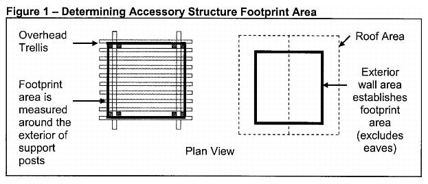
5. “Footprint” shall mean the area under an accessory structure as seen in plan view, measured horizontally from the outside of all exterior walls or supporting columns or posts at floor level (e.g., excluding eaves). Figure 1 illustrates determining footprint area.
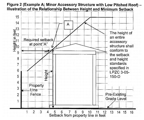
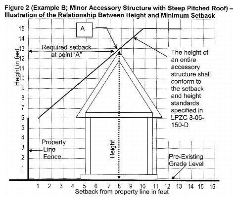
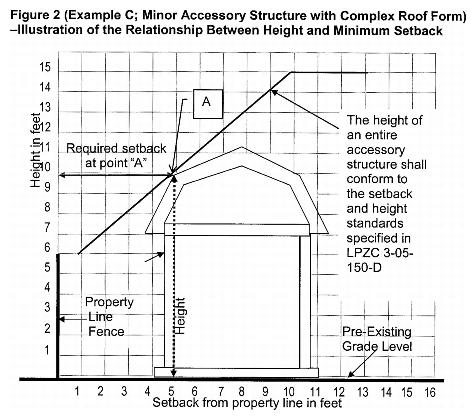
6. “Height” for the purpose of establishing required setbacks shall be defined for every point within the footprint area of an accessory structure, including a treehouse, as the vertical distance between grade and the highest part of the structure directly above. Height in all cases shall include any slab, platform, pad, mound or similar elevated base above preexisting grade. Figure 2 (Examples A, B, C, and D, below) provides examples that illustrate the relationship between height and minimum setbacks. The height of an entire accessory structure shall conform to the setback and height standards specified in subsection (D) of this section.
7. “Open structure” means an accessory structure having a roof constructed of lattice or other roof material which allows light and air to pass through a minimum of 50 percent of the roof surface. Additionally, the sides of an open structure consist only of support posts and decorative or functional elements such as braces and railings such that light and air can pass through a minimum of 75 percent of each side. Open structures include but are not limited to trellises, trellis-like patio covers, and other shade structures. Play structures do not qualify as open structures, but are regulated as minor or major accessory structures.
8. “Primary dwelling frontage” means the space extending across the front of a lot following a line along the front wall of a primary dwelling outward to the nearest side property line, and extending forward to the public right-of-way. Figure 3 illustrates determining primary dwelling frontage.
D. Setback and Height Regulations.
1. The required setback is determined by the type of accessory structure, the footprint area of the accessory structure, and the height of the structure, as described below. Projections of eaves and overhangs that conform to LPZC 3-05-130(A) and 3-05-140(A) (eaves may project from the accessory structure a distance not to exceed one-half of the required setback, but not more than five feet) are not considered when determining setback requirements. Setbacks are measured from the nearest property lines as specified below and illustrated by Figure 4, except for accessory structures adjacent to a major street right-of-way, which are regulated by subsection (D)(2)(d) of this section.
a. Open Structures. Any open structure as defined in this section, regardless of footprint size, may be located adjacent to a property line provided it does not exceed six feet in height. The setback shall increase by one foot from the property line for every one-foot increase in height above six feet, subject to the maximum height regulations of subsection (D)(2) of this section.
b. Minor Accessory Structures. The minimum setback shall be one foot for a minor accessory structure not exceeding six feet in height and the setback shall increase by one foot for every foot above six feet, subject to the maximum height regulations of subsection (D)(2) of this section.
c. Major Accessory Structures. The minimum setback shall be three feet for a major accessory structure not exceeding six feet in height and the setback shall increase by one foot for every foot above six feet, subject to the maximum height regulations of subsection (D)(2) of this section. For properties designated RL, detached garages used primarily for the off-street storage of vehicles shall have a minimum three-foot setback, provided the property is rectangular in shape and has 50 feet or less street frontage.
2. The following height and setback regulations shall apply to all accessory structures:
a. The maximum height of an accessory structure shall not exceed one story up to a maximum of 15 feet measured to its highest point, except play structures may include two stories. For the purposes of this section, a play structure is an accessory structure principally designed and used for children at play.
b. A rooftop designed so that it may be used as a deck shall be considered a second story for the purposes of this chapter, and shall not be permitted except for decks on play structures that are six feet or less above ground level.
c. Uncovered landscape features and structures, such as decks, porches, patios, uncovered and unenclosed walkways, and uncovered decks on play structures and treehouses shall conform to the setback and height regulations of LPZC 3-05-140(F). (Minimum setback for decks that are three or more feet above grade shall be 10 feet or the setback required by this section, whichever is greater.)
d. Accessory structures shall not be permitted within 50 feet of the right-of-way of a major street as identified by the general plan, except as permitted by the following regulations:
i. Accessory structures shall be located behind a sound wall or solid fence. For the purposes of this section, a solid fence shall be defined as one that is constructed of a material that allows light and air to pass through no more than 10 percent of the surface.
ii. The minimum setback for accessory structures not exceeding six feet in height shall be six feet, measured from the sound wall or solid fence. The setback shall increase by one foot for every one-foot increase in height above six feet, subject to the maximum height regulations of this subsection (D)(2). Figure 5 illustrates accessory structure setbacks from the sound wall or solid fence.
E. Coverage and Numeric Limits.
1. The footprint area of a single accessory structure shall not exceed 640 square feet.
2. The maximum coverage of all accessory structures greater than six feet in height on a residential lot shall not exceed 10 percent of the lot size or 1,000 square feet, whichever is less. The first 500 square feet of footprint area for open structures greater than six feet, but not more than nine feet, in height shall not be counted when determining the amount of coverage.
3. The total number of accessory structures greater than six feet in height on a residential lot shall not exceed five of which no more than two may be major accessory structures. The first two open structures greater than six feet, but not more than nine feet, in height shall not be counted when determining the total number of accessory structures on a residential lot. Additionally, accessory structures located in the primary dwelling frontage shall not be counted when determining the total number of accessory structures on a lot.
4. Floor area within accessory structures that conform to the size, coverage, and numeric limits of this subsection (E) shall not be included when calculating the floor area ratio or coverage limit, whichever applies, of the underlying zoning district.
F. General Regulations. The following regulations shall apply to all accessory structures which are not exempt per subsection (B) of this section.
1. A building permit shall be required for any accessory structure when required to conform to the building code, including but not limited to when an accessory structure has a footprint of greater than 120 square feet, contains light fixtures or heating appurtenances, or is otherwise served by a utility such as electricity, gas, or plumbing, or is structurally attached to a dwelling or another accessory structure.
2. Where a standard in the underlying zoning district or planned unit development (PUD) addresses a specific accessory structure standard (e.g., height or setback) those standards shall take precedence over this section.
3. Accessory structures shall not be located in a primary dwelling frontage, except for the structures listed in subsection (B)(3) of this section.
4. Accessory structures not within a primary dwelling frontage but located within 50 feet of a street right-of-way shall be located behind a conforming six foot fence, except for detached garages.
5. Limitations on Use.
a. An accessory structure shall be permitted on a lot only in conjunction with a primary dwelling unit.
b. Use of an accessory building as a dwelling unit, sleeping quarters, or a housekeeping unit is prohibited, unless permitted as an approved secondary dwelling unit, subject to the provisions of LPZC 3-10-020 (Secondary dwelling units).
c. A bathroom is permitted within an enclosed accessory structure.
d. A kitchen is prohibited in an enclosed accessory structure, unless permitted in an approved secondary dwelling unit, subject to the provisions of LPZC 3-10-020.
e. A shipping container is not permitted as an accessory structure in a residential zoning district.
6. Separations.
a. A minimum three-foot separation shall be maintained between an accessory structure and all other structures on a lot, measured from exterior vertical wall or post surfaces, except as noted in subsections (F)(5)(c) and (d) of this section.
b. Accessory structures attached to a primary dwelling shall be subject to all standards of the underlying zoning district, except as noted in subsections (F)(5)(c) and (d) of this section.
c. An accessory structure with a covered breezeway separating the accessory structure from a primary dwelling shall be considered a detached accessory structure.
d. Patio covers may be attached to the primary dwelling provided all accessory structure regulations, including required setbacks and numerical and coverage limits of this section, shall apply to the attached accessory structure.
7. Deviating from any standard in this section may be authorized upon approval of a conditional use permit.
8. Design Standards and Maintenance.
a. Accessory structures shall be designed to complement or match the appearance of the primary dwelling unit and be consistent with the residential character of the neighborhood. Colors, materials, roof form, windows, window trim and other architectural features shall complement or match those of the existing primary dwelling unit. Accessory structures shall be constructed using conventional construction methods and materials for accessory structures, including accessory structures commonly premanufactured or prefabricated for sale and use in residential settings.
b. An accessory structure shall be located and designed to not drain onto other property, and shall not be structurally attached to a property line fence.
c. Lighting affixed to an accessory structure shall be designed or shielded to not cause glare upon neighboring properties.
d. Accessory structures containing fuel-burning appurtenances shall be equipped with a spark arrestor when required by local and/or state fire codes.
e. Accessory structures shall be maintained in good repair, in conformance with LMC 8.14.020(H), and such that members of walls, posts or roof coverings, whether open or solid, or exterior sheathing shall not lean, list, buckle, or otherwise appear to fall or fail due to defective materials or deterioration. (Ord. 1825 § 2, 2007)
3-05-160 Dwelling groups.
In no case shall any separate buildings of a dwelling group be closer to any other building of the group than a distance of 10 feet. Distances required between buildings on the same lot and for yards and courts shall be increased by two and one-half feet for each story that the height of any building in a dwelling group exceeds one story. In case the buildings of the dwelling group are so located on the lot that the rear of the building which faces the street is faced by the front of a building to the rear (in front to back series), no such building shall be closer than 20 feet to any other such building, and the side yard providing access shall not be less than eight feet.
In case a building is so located on the lot that the rear thereof abuts upon one side yard and the front thereof abuts upon the other side yard (in a single row side-to-side series), the side yard providing access shall have a width of not less than 12 feet. In case the buildings of a group are so located on the lot that the rear thereof abuts upon each side yard and the fronts thereof face a court (in a double row side series), the court shall have a width of not less than 20 feet. (Ord. 442 § 20.52)
3-05-170 Buildings in rear of main buildings.
No building in the rear of a main building on the same lot shall be used for residential purposes unless it conforms to all the yard and other open space and off-street parking requirements of this code, and for the purpose of determining the front yard in such use, the rear line of the required rear yard of the main building in the front shall be considered the front lot line for the building in the rear. (Ord. 442 § 20.53)
3-05-180 Accessory structures and uses.
Accessory structures and uses as defined in Chapter 1-10 LPZC shall conform to all applicable zoning district regulations and special regulations in LPZC 3-05-190, et seq. (Ord. 442 § 20.60)
3-05-190 Fences.
Fences, to include walls, and similar dividing instrumentalities shall be subject to the following regulations:
A. Fences shall not be permitted between any non-street frontage side property line and the building setback line adjacent to an existing building, except that a fence or gate may be erected perpendicular to the property line so as to complete lot enclosure.
B. Fences in excess of three feet in height shall not be permitted within any required street frontage yard, except as follows:
1. The initial two feet of a retaining wall shall not be considered a portion of a fence.
2. A fence or wall having a height of not more than six feet may project five feet into any required street frontage yard, provided:
a. Lineal length of such fence does not exceed 75 percent of the lot frontage.
b. Such projection does not occur adjacent to the intersection of lines tangent to the right-of-way of two intersecting streets as shown on Diagram “A”.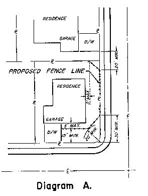
c. Within the RM district, corner lots shall maintain a setback of not less than 15 feet on one of its frontages.
3. A fence or wall having a height of not more than six feet may be located on the property line, but in no case closer than five feet from the back edge of the sidewalk, on one of the street frontage yards of a corner lot, provided:
a. The area between fence and sidewalk shall be provided with an irrigation system and shall be permanently maintained as a landscaped strip. Nonpervious surfacing shall not exceed 25 percent of the area.
b. Fences shall be supported by posts or piers of redwood, concrete, or steel, located not more than eight feet apart, and imbedded in concrete or having a concrete foundation.
c. Fences shall be subject to design review approval.
d. No such fence shall be located within twenty feet of any driveway.
e. Fences shall conform to subsections (B)(2)(a) through (c) of this section.
C. Except as noted in subsections (A) and (B) of this section, fences and walls shall be permitted anywhere on the property; however, fences or walls having a height in excess of six feet shall conform to the zoning code requirements regulating principal or accessory buildings.
D. A wall erected on a property line as part of an accessory building or structure and in conformance with requirements set forth in this code may observe the height limit of the district.
E. Subject to the limitations stated in subsections (A) and (B) of this section, fences or walls having a height no greater than six feet may be erected on or contiguous to property lines for purposes of enclosing property.
F. Where otherwise permitted or required by this code or around private and public recreation courts, fields, or similar play areas, fences in excess of six feet in height shall be allowed.
G. Fences or walls, where required by this code, shall be of permanent construction of wire, wood, or masonry with all supporting structures set in a concrete foundation approved by the city building department. Any fences in excess of eight feet in height shall be constructed of open wire.
H. Barbed wire shall not be used in the construction of any fence except as a protective device no less than five feet above the finished grade of the base.
I. Notwithstanding the six-foot fence height limitation of subsections (B)(3), (C) and (E) of this section, and subject to conditional use permit approval, a fence to a maximum height of eight feet may be constructed on a side or rear property line of a lot abutting a truck route designated street (LMC 10.24.010); provided, the fence does not exceed six feet in height within 20 feet of the intersection of lines tangent to the right-of-way of two intersecting streets. (Ord. 1354, 1991; Ord. 1110, 1982; Ord. 936, 1977; Ord. 442 § 20.61)
3-05-200 Signs.
For sign provisions, see Chapter 3-45 LPZC. (Ord. 442 § 20.62)
3-05-210 Landscaping features and structures.
Repealed by Ord. 1572. (Ord. 442 § 20.63)
3-05-220 Landscaping materials.
Landscaping, where required by this code, may consist of grass, trees, shrubs, flowers, or other living ground cover. The use of gravel, tanbark, synthetic plant material, decorative paving, artificial ground covers, and similar materials shall be subject to the approval of the city. Pavement and/or walks shall not exceed 20 percent of the required landscaped area. Such landscaped areas shall be permanently maintained and irrigated through installation of an automatic sprinkler head irrigation system. (Ord. 442 § 20.64)
3-05-230 Swimming pools.
For swimming pool provisions, see LPZC 3-50-100. (Ord. 442 § 20.65)
3-05-240 Reserved.
3-05-250 Interstate 580 plan lines.
The city has adopted right-of-way plan lines for Interstate 580 for the purpose of protecting and preserving areas for regional transportation improvements such as Bay Area Rapid Transit (BART), high occupancy vehicle (HOV) lanes, and other future modal options. The amount of land necessary will vary according to I-580 plan lines.
Plan lines are the boundaries and limits of a planned right-of-way, including the future right-of-way of an existing transportation corridor as it is proposed to be widened. These lines also include all lands necessary for the building, widening, or maintenance of any road, street, highway, or any other type of public way, which planned right-of-way is based on the general plan of Livermore. (Ord. 1855 § 1, 2008)
3-05-260 Creation of special building lines.
For the purpose of measuring yard dimensions and determining building lines, there are the following special building lines as shown on zoning district maps enacted pursuant to Chapter 2-04 LPZC:
A. East Avenue, between South Livermore Avenue and Greenville Road, within and without the corporate limits of the city of Livermore, to provide special building lines.
B. Hillcrest Avenue, from East Avenue to a point distant thereon 890 feet north of East Avenue, to provide special building lines.
C. First Street, between Scott Street and U.S. Highway 580, within and without the corporate limits of the city of Livermore, to recognize district setback lines.
D. Vasco Road, between Tesla Road and U.S. Highway 580, within and without the corporate limits of the city of Livermore, to provide special building lines.
E. Vasco Road, between U.S. Highway 580 and Dalton Avenue, within and without the corporate limits of the city of Livermore, to recognize district setback lines.
F. Holmes Street, on the east side between Concannon Boulevard and the south boundary of Tract 2914, to provide a special building line (setback line) of 60 feet, measured from the future right-of-way line.
G. Concannon Boulevard, on the north side, between Holmes Street at the west boundary of Tract 2914, to provide a special building line (setback line) of 60 feet measured from the future right-of-way. (Ord. 1032, 1980; Ord. 442 § 20.72)
3-05-270 Heights of buildings and structures.
A. Special Structure Heights. Subject to any other provisions of law, certain structures as listed below may be erected to greater height than the limit established for the district in which such structure or use is located; provided, however, that all structures above the height otherwise permitted in the district shall not occupy more than 25 percent of the area of the lot and shall be distant not less than 25 feet in all parts from every lot line: church spires, belfried cupolas and domes, monuments, water towers, observation towers, gables, flagpoles, masts, commercial radio transmission towers, vents and chimneys; parapet walls extending not more than four feet above the limiting height of the building; outdoor theater screens, provided said screens contain no advertising matter; smoke stacks, cooling towers, grain elevators, gas holders, and other structures where the manufacturing process requires greater height.
B. Subject to any other provisions of law, certain structures as listed below may be erected to greater height than the limit established for the district in which such structure or use is located: bulkheads, elevator penthouses, monitors, and scenery lofts, provided no linear dimensions of any such structure exceed 50 percent of the corresponding street lot line frontage; barns, silos, windmills, or other farm buildings or structures, provided these are not less than 50 feet from every lot line; single poles or metal towers erected for the purpose of supporting aerials for radio transmission and receiving by licensed amateur radio operators, provided, however, that no portion of said aerial structure shall overhang or extend over adjacent property or public utility transmission and distribution lines; television and radio receiving antennas not exceeding a height in a residential district greater than 45 feet measured from ground level; provided, however, that the distance from the base of such antenna located in commercial areas shall be located a distance from every property line equal to its height. Such antenna located in commercial areas shall not exceed a height greater than 10 feet above the height limit for the district in which the structure is located.
C. Notwithstanding structural limitations found elsewhere in this code, nor exceptions to those height limitations found in this section, the height of structures located within 5,000 feet of any airport runway shall not exceed 40 feet. (Ord. 1001, 1979; Ord. 442 § 20.80)
3-05-280 Sloping lot height measurement.
In any district on lots that slope, the maximum height of the structure shall be as set forth in the district and measured vertically from ground level at the front yard setback line, or if no yard is required, at the center of the lot. (Ord. 442 § 20.82)
3-05-290 Exceptions to height limitations.
In a district with a height limit of less than 75 feet, public and semi-public buildings, structures and uses permitted in such district may be erected to a height not to exceed 75 feet with approval of a conditional use permit; provided, that the yards shall be increased one foot for each one foot of height that such building exceeds the height limit hereinbefore established for such district. (Ord. 1810 § 4, 2007; Ord. 442 § 20.83)
3-05-300 Grading activities.
A. Except as identified in subsection (B) of this section and specifically identified in the general plan, the following grading activities are permitted:
1. The on-site filling, movement, excavation or removal of materials for construction activities for which a zoning or subdivision entitlement has been granted and where the environmental document prepared in accordance with the California Environmental Quality Act (CEQA) adequately evaluates the proposed activity.
2. Any excavation less than 10 feet in depth to be held in place by support structures such as foundations, and swimming pools.
3. Any excavation less than five feet in depth either having finished slope less than one and one-half horizontal to one vertical or held in place by support structures such as a retaining wall.
4. Any fill either less than two feet in height with a slope less than five horizontal to one vertical or less than 200 cubic yards.
5. Excavations by any public agency or public utility for the installation, operation, inspection, repair, or replacement of any of its facilities.
6. Emergency work authorized by the city necessary to protect life, limb or property.
7. Farming activities.
B. The following grading activities are subject to the issuance of a conditional use permit:
1. Any activity not permitted by subsection (A) of this section.
2. Mining, quarrying, excavating, processing, stockpiling of rock, sand, gravel, aggregate, soil or clay for commercial purposes unrelated to development of the subject property.
3. Any grading activity either within a flood hazard zone established by the Federal Emergency Management Agency or within 150 feet of the top of the bank of any creek, arroyo or drainage channel.
4. Any activity on a site not authorized by a construction project where significant vegetation will be removed. For the purposes of this section, “significant vegetation” consists of any plant where the diameter of a trunk is six or more inches, four feet above the grade.
C. Grading of any parcel of land for a permitted use where no bank is left standing and exposed of more than 10 feet in vertical height, or when less than 1,000 cubic yards of earth are removed from the premises, is permitted in all districts.
D. Grading in a subdivision which has been approved by the city in accordance with the Livermore subdivision ordinance and any amendments thereto is permitted in all districts.
E. Excavations by any public agency or public utility for the installation, operation, inspection, repair, or replacement of any of its facilities are permitted in all districts.
F. No provision of this code shall be construed as permitting any ground excavation in any zone within any district for the purpose of conducting commercial sand, rock, and gravel by-product operations. (Ord. 442 §§ 20.90 – 20.95)
3-05-310 Public utility undergrounding.
A. For the purpose of this section the following definitions shall apply:
1. “Utilities” means all utility lines, including but not limited to any electrical line(s) less than 60 kV, all cable television, video, data, communication, telecommunication and similar lines and associated utility boxes.
2. “Abutting street right-of-way” means the area between the street centerline and the edge of the street right-of-way, in which utilities serving property adjacent to the right-of-way are located. When undergrounding of utilities in the abutting street right-of-way is required in this section, it shall mean that undergrounding is required to the next existing utility pole in the street right-of-way, even if the pole is not located along the frontage of the property on which the project is located.
3. “Addition” means a new structural attachment to an existing structure and/or a new separate detached structure on a site developed with an existing structure(s) that results in an increase in the total floor area.
B. All new on-site utilities for new construction projects shall be located underground.
C. Existing on-site utilities, new and existing aboveground utilities located in the abutting street right-of-way shall be located underground for any of the following projects:
1. Subdivision of nonresidential-zoned land, including condominiums and condominium conversions;
2. New construction of buildings for nonresidential use on vacant sites or on developed sites where existing buildings will be completely demolished for redevelopment;
3. Additions to nonresidential buildings where the addition is 10,000 square feet or more in floor area and amounts to 50 percent or more of the floor area of the existing building;
4. Partial reconstruction of existing nonresidential buildings where the reconstructed portion of the building is 10,000 square feet or more in floor area and amounts to 50 percent or more of the floor area of the existing building;
5. Residential projects of five or more units, including single-family residential subdivisions, single-family residential developments, multiple-family residential developments, new condominiums and condominium conversions;
6. Installation of and modifications to utilities.
D. Payment Option.
1. If a property owner is required to underground utilities under subsection (C) of this section, the property owner may instead pay for the cost of undergrounding utilities if one or more of the following circumstances apply:
a. There would be no net decrease in utility poles required to support existing aboveground facilities after undergrounding was accomplished. This eligibility criterion shall not apply to projects in which the number of poles is not decreased because the remaining poles are required to support high voltage electrical lines (60 kV or higher);
b. A project has been identified in a city capital improvement program (CIP), adjacent to the development, for design or construction within the next five years and it is more economical to combine the undergrounding work with the city CIP project;
c. The project site is one acre or less in area;
d. The cost of undergrounding aboveground utilities would be more than 10 percent of the total site development cost.
2. A property owner requesting the payment option shall submit a written request to the city engineer. The city engineer shall determine whether the project is eligible for the payment option and the reasonable amount of payment following the procedures of subsection (D)(3) of this section.
3. If the city engineer determines that the property owner is eligible for the payment option, then the property owner shall submit a cost estimate for the undergrounding of utilities. The cost estimate shall be based on a project large enough in scope for Pacific Gas and Electric Company (PG&E) to approve it and sufficient in detail to demonstrate the full extent of the work required. Supporting calculations shall be provided. The cost estimate shall show the total cost of the larger PG&E project and the property owner’s fair share of the total project cost, which shall be based primarily on the length of utility lines along the frontage of the project site relative to the total length of utility lines of the larger PG&E project area, plus other conditions including, but not limited to, the number of service connections and the location of poles and transformers. The cost estimate and supporting calculations shall be prepared by an electrical engineer, registered in the state of California and qualified to provide underground design services.
4. Payment shall be made at the time of building permit issuance.
5. If the city engineer determines a hardship exists, a property owner may pay for the cost of undergrounding after the time a building permit is issued. Before the building permit is issued, the property owner shall enter into a written agreement with the city and record the agreement with the Alameda County recorder with the following contents. The agreement shall be signed by the property owner and shall include the following provisions, in a form prepared by the city attorney:
a. A legal description of the property;
b. A provision that the agreement runs with the land and is enforceable against successors in interest;
c. The agreement shall be recorded in the grantor-grantee index in the name of the city as grantee and in the name of the property owner as grantor;
d. A provision that the property owner shall pay the fee within five years;
e. A provision that the amount of the fee due will be the amount due on the date of the agreement plus a periodic increase based on the Engineering News Record (ENR) 20-City Construction Cost Index; and
f. A requirement that, with the opening of any escrow for the sale of the property, the property owner provide appropriate notification and escrow instructions that the fee be paid to the city from the sale proceeds in escrow before disbursing proceeds to the seller.
6. When the obligation is paid in full, the city shall record a release of the obligation.
7. The community development director is authorized to sign the agreement and the release of obligation under subsections (D)(5) and (6) of this section.
8. The city shall deposit the payments received under subsections (D)(4) and (5) of this section in a separate fund, which shall be used only for utility undergrounding projects in the city.
E. The city engineer shall have the authority to waive the undergrounding requirements of this section for the following facilities, uses or conditions:
1. Temporary and intermittent uses, as defined in LPZC 3-10-320, subject to removal of all utilities serving the temporary or intermittent use after termination of said use;
2. Transformers, terminal boxes, meter cabinets and similar appurtenant utility facilities;
3. Sites where undergrounding is impractical because of topography, soil conditions, or other extraordinary physical constraints.
F. Any person aggrieved by a decision of the zoning administrator, city engineer, planning commission or other administrative official in the administration or enforcement of this section of the code may appeal the decision in accordance with the procedures set forth in Chapter 5-15 LPZC. (Ord. 1791 § 1, 2006; Ord. 1639 § 1, 2001)
3-05-320 Mechanical equipment screening.
For all new installation or relocation of existing mechanical equipment for commercial/industrial development, the equipment shall be screened from public view whether installed on the roof, ground or walls.
A. Roof-Mounted Equipment. Building parapets shall screen roof-mounted equipment.
1. New buildings shall be designed to provide a parapet that is as tall as or taller than the highest point on any new mechanical equipment to be located on the roof of the building.
2. For existing buildings with no or low parapet heights, mechanical equipment shall be surrounded on all sides by an opaque screen wall as tall as the highest point of the equipment. The wall shall be architecturally consistent with the building and match the existing building with paint, finish, and trim cap detail. All new roof screens shall be subject to administrative design review or may be referred to the planning commission as determined by the zoning administrator.
B. Wall- and Ground-Mounted Equipment.
1. Shall not be located between the face of the building and the street.
2. All screen devices shall be as high as the highest point of the equipment being screened. Equipment and screening shall meet rear and side yard setbacks of the district it is located in.
3. Screening shall be architecturally compatible and include the matching paint, finish and trim cap of the building.
4. All new mechanical screens for ground or wall-mounted equipment shall be subject to administrative design review or referred to the planning commission as determined by the zoning administrator. (Ord. 1861 § 1, 2009; Ord. 1664 § 3, 2002)