


Chapter 3.6
Other Standards
Sections:
3.6.110 Wireless Telecommunication Facilities
3.6.100 Signs
The following regulations apply to all signs erected, placed and displayed including painted wall signs. These regulations are intended to improve the commercial environment, atmosphere, and visual quality of the community.
Nothing in this ordinance shall restrict the placement and maintenance of public service and directional signs, traffic control signs and devices, legally required signs, state and national flags, flags and banners for special occasions.
A. Signs for Residential use. A residential use is allowed residential identification signs to identify the residents, street name and number, name of building or building complex name. For home occupations, a sign of no more than six (6) square feet is allowed.
B. Signs for Commercial and Industrial Uses. A commercial use located in any zone where it is authorized, or an industrial use located in the Industrial District is allowed the following signs:
1. Business signs: Maximum sign area for any business or sites three hundred (300) square feet of sign area, or one and one half (1-½) square feet of sign area per linear foot of building front, whichever is smaller. Building front in this case shall mean the wall of the building that contains the main entrance. Any business is allowed thirty-five (35) square feet of sign area, regardless of building frontage. The maximum allowable sign area may be composed of one type of sign or any combination of wall or window signs, pole signs, ground signs and projecting signs.
2. Wall or window signs: Subject to the limitations specified above, a wall sign shall not exceed forty percent (40%) of the area of the wall minus the area of doors and windows. A wall or window sign shall not face the same direction as a roof sign.
3. Pole or ground signs: Subject to the limitations specified above, one pole or ground sign is allowed per business if the business has one hundred (100) feet of frontage on a public street. The pole or ground sign area shall not exceed one-half the total area of all sign faces allowed for the business. The maximum sign height is twenty-five (25) feet.
4. Projecting signs: Projecting signs which are attached perpendicular to a building are allowed up to maximum are of fifteen (15) square feet. Projecting signs are not allowed in combination with a pole or ground sign unless the signs are separated by fifty (50) feet or more.
C. Prohibited signs. The following signs are prohibited: Signs which interfere with traffic visibility or resemble traffic control signs, signs which have not been kept in good repair, signs which flash or rotate, signs which are excessively bright (determined by considering the size of the sign, the percentage brightness of the white or light colored portions of the sign, the distance to the public right-of-way, and the nature of the surrounding areas), signs mounted on the roof of a building, off- premise signs, signs on a public right-of-way, signs overhanging a public sidewalk at a height of less than eight (8) feet or to within two (2) feet of the edge of the pavement of a public street, signs overhanging a public street at a height of less than sixteen (16) feet above, bulb signs, banners, flags, and pennants, except as allowed herein, signs which unnecessarily block or interfere with existing signs. No sign shall be permitted that has the appearance of movement (except time and temperature signs and traditional barber poles) within the Main Street Commercial Subdistrict.
D. Existing signs. All legal signs existing at the time of adoption of this ordinance may be maintained. Signs pertaining to a business that has not been in operation for at least ninety (90) days, shall be removed.
1. Existing signs that do not conform to this ordinance due to characteristics of the sign and the site, or due to the zoning designation of the site, may be altered if the alteration does not exceed 50% of the value of the sign. The value of the alteration and the value of the sign shall be determined by City Staff.
2. A new sign which is to replace an existing sign that does not conform to this ordinance due to characteristics of the sign or the site shall conform to this ordinance. A new sign which is to replace an existing sign which does not conform to this ordinance due to zoning designation of the site, is allowed providing the new sign is more conforming with this ordinance, that is, it is smaller, shorter, less bright, etc.
3.6.110 Wireless Communication Facilities
A. Purpose. The purpose of this section is to provide siting standards and review processes for wireless communications facilities (WCF’s) locating within Halsey’s urban growth boundary. These regulations are designed to:
1. Regulate the placement, appearance, and number of WCF’s.
2. Ensure that the citizens of Halsey have access to wireless communications services.
3. Reduce the visual impact of towers by encouraging collocation.
4. Establish a graduated system of review that will expedite approval on certain sites.
5. Implement the applicable provision of the Telecommunications Act of 1996.
B. Definitions
Antenna: The specific device used to capture an incoming and/or transmit an outgoing radio- frequency signal. Common types include whip, panel, microwave dish, and GPS antennae.
Attached WCF: An existing pole, tower, steeple, or other structure, such as an elevator shaft on a rooftop, capable of accommodating WCF antennae, whether originally designed for such use or not.
Collocation: Two or more WCF providers utilizing a structure or site specifically designed and/or approved for such multiple use.
Detached WCF: A pole, tower, or other structure specifically designed and intended to support WCF antennae.
Lattice Tower: A WCF support structure which consists of metal crossed strips or bars which supports antennae and related equipment for one or more service providers.
Monopole: A WCF support structure which consists of a single tapered steel pole and which supports antennae and related equipment for one or more service providers.
Stealth Design: A variety of techniques used to disguise or mitigate the visual presence of a WCF support structure, including, but not limited to screening by mature trees, mimicking common features of the urban landscape (light poles, steeples, flag poles, trees, etc.), or painting to blend into surrounding features.
Wireless Communications Facilities (WCF): The site, structures, equipment shelters, and appurtenances used to transmit, receive, distribute, or provide telecommunications services.
C. Review Process
The review process for WCF’s is based on the site’s zoning, including proximity to the Residential District and residential uses, and the type of facility proposed (detached WCF, attached WCF, or collocation), as depicted in Table 3.6.110.C below.
Table 3.6.110.C
Review Process for Wireless Communications Facilities
|
|
Type of Facility |
||
|---|---|---|---|
|
Zoning District |
Collocation |
Attached Facilities |
Detached Facilities |
|
Main Street Commercial Subdistrict |
DR |
DR |
Not Allowed |
|
Commercial <100 ft. from Residential District or use |
DR |
SDR |
CUP |
|
Commercial >100 ft. from Residential District or use |
DR |
DR |
SDR |
|
Industrial <100 feet from Residential District or use |
DR |
DR |
SDR |
|
Industrial > 100 ft. from Residential District or use |
DR |
DR |
SDR |
1. DR: Development Review. Submit development plan application for administrative review by City Planner – see Chapter 4.3.
2. SDR: Site Development Review: Submit a site development plan application for review by the Planning Commission – see Chapter 4.3.
3. CUP: Conditional Use Permit. Submit CUP application for review by Planning Commission - see Chapter 4.5.
4. Prohibited WTC’s – Detached WCF’s are prohibited in the Residential District and in the Main Street Commercial Subdistrict. All WCF’s are prohibited on buildings or sites listed on the Halsey Register of Historic Resources, see Chapter 3.6, Section 3.6.130.
D. Siting Standards
1. All WCF’s shall observe minimum lot size, coverage, and setback requirements of the underlying zone. New facilities over 75 feet tall and extensions of more than 20 feet shall have Planning Commission approval, regardless of the review process listed in Table 3.6.110.C.
2. WCF’s shall be planted with perimeter evergreen landscaping that will form a solid screen around the base of the facilities within 5 years, where applicable.
3. Detached WCF’s shall not be located inside or within 100 feet of the Residential District or within 100 feet of existing residences unless it is shown there are no alternative sites available.
E. Application Requirements
1. DR: Development Review. Applicants shall submit the following materials for facilities which qualify for development review, as shown in Table 3.6.110.C:
a. A copy of the lease agreement with the property owner that includes collocation provisions, facility removal within 90 days of abandonment, and a bond to guarantee removal;
b. A signed statement from the applicant agreeing to allow collocation on the facility, where applicable;
c. A map of the area showing the approximate geographic area to be served by the facility, existing facilities within 1,000 feet of the proposed facility, other facilities in the area owned or operated by the applicant and the nearest potential collocation sites;
d. A plot plan showing the lease area, antenna structure, equipment shelters, height above grade, setbacks from property lines, access and parking, connection point to land lines, and landscaping intended to screen the proposed facility.
e. Any stealth design features;
f. An engineer’s statement that the RF emissions at grade, or at nearest habitable space, comply with applicable FCC emissions standards.
g. A description of the type of service being offered
h. Identification of the provider and backhaul provider, if different;
i. The RF range in Megahertz and the wattage output of the equipment
j. Facilities maintenance regimen;
k. Zoning and comprehensive plan designation of site; and
l. FAA determination.
2. Applications for WCF’s that require Site Plan Review shall submit the above information and:
a. An engineer’s analysis or report covering the recommended area for a new facility. If the engineer’s search area recommendations include another facility with potential for collocation, reasons for not collocating shall be provided and must demonstrate one of the following: the structure is not of sufficient height to meet engineering requirements; the structure is not of sufficient strength to accommodate the proposed facility; electromagnetic interference for one or both WCF would result from collocation; or the radio frequency coverage objective cannot be adequately met for some other technical reason.
b. Photo-simulations showing the proposed facility from at least two vantage points, including from the nearest residence.
3. Applications requiring a Conditional Use Permit shall provide the information required in sections (1) and (2) above, and additionally provide:
a. An engineer’s statement describing why the proposed facility must be located at the proposed site;
b. An engineer’s statement describing why the facility must be constructed at the proposed height;
c. A statement describing the good faith efforts made to site or design the facility to qualify for a less rigorous review process (Development Review, Site Plan Review).
Conditional Use Permit applications for WCF’s shall be evaluated on the above three criteria in addition to the standard CUP criteria contained in Chapter 4.5
3.6.120 Sensitive Lands
The City of Halsey wishes to protect sensitive lands within the urban growth boundary, including flood hazard areas, jurisdictional wetlands, and significant vegetation (there are no areas characterized by steep slopes within the UGB). New development shall be designed to the maximum extent feasible to avoid and/or protect sensitive lands.
A. Flood Hazard Areas. Any development on land located within the 100-year flood plain shall comply with Chapter 3.7 “Floodplain Standards”.
As of July 1, 2018, no land in Halsey is designated by the Federal Emergency Management Agency (FEMA) as being located in a 100-year flood plain or flood hazard area. Nonetheless, areas of localized flooding do occur, particularly in the 500-year flood zone within the banks of Halsey’s open drainage ditches. The Storm Drainage System Master Plan recommends system improvements to alleviate some of the problem areas. At a minimum, new development shall not increase existing flooding problems or create new ones. New development shall comply with the requirements in Section 3.5.140 -Storm Drainage.
B. Jurisdictional Wetlands. Areas identified on the National Wetland Inventory (NWI) maps may be jurisdictional under state or federal wetland regulations. If more than 50 cubic yards of fill is proposed, a fill permit may be required by the Division of State Lands and/or the Army Corps of Engineers, prior to ground disturbance. Development is encouraged to avoid wetland areas for their ecological, flood storage, and water filtration qualities. In many cases wetlands can be incorporated into the overall drainage system for a development without significantly restricting buildable area.1
Figure 3.6.120—National Wetlands Inventory Map (2018)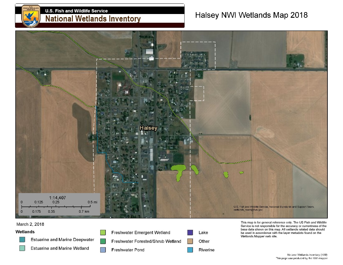
C. Significant Vegetation. Significant vegetation is defined in Chapter 3.3, Landscaping. Development is encouraged to avoid existing attractive vegetation, including individual trees, stands or groves of trees, and waterside vegetation. Native vegetation is given priority over introduced species.
3.6.130 Historic Properties
A. Preserving Halsey’s Historic Character. The City encourages the preservation of its historic buildings. Historic preservation programs, including a storefront improvement program, tour of historic homes, nominations to the national Historic Register, and historic displays are encouraged and supported by the City of Halsey. Design standards for new construction encourage replication of design features found in Halsey’s historic buildings. By encouraging development inspired by history, Halsey hopes to enhance the appearance and character of the town as a whole.
B. Halsey Register of Historic Properties. The Halsey Comprehensive Plan established a local Register of Historic Resources in order to protect and promote one of the community’s greatest assets. The register, located in Appendix “A” of the Halsey Comprehensive Plan, includes historic homes, commercial buildings, churches, and” industrial buildings. The register includes a description and photo of each property. Provisions related to designation and removal of specific properties are contained in the Comprehensive Plan. Table 3.6.130 provides a list of the buildings, structures and sites on the local register of historic places and identifies the structures that are also listed on the State of Oregon Register of Historic Resources.
Table 3.6.130
City of Halsey Register of Historic Properties
|
# |
Location |
Name or Description |
Listed on SHPO Register |
Listed on NHP Register |
|---|---|---|---|---|
|
HR-1 |
100 Halsey Street |
Southern Pacific Railroad Depot |
Yes |
No |
|
HR-2 |
773 W First Street |
Halsey Public Library |
Yes |
No |
|
HR-3 |
751 W First Street |
Halsey State Bank Building |
Yes |
No |
|
HR-4 |
891 W 1st Street |
Cross and White Hardware Store |
Yes |
No |
|
HR-7 |
791 W 4th Street |
Koontz House |
Yes |
No |
|
HR-8 |
1365 W 3rd Street |
Rector-White House |
Yes |
No |
|
HR-10 |
411 W 2nd Street |
Halsey Christian Church |
Yes |
No |
|
HR-11 |
817 W 3rd Street |
Thompson-Bond-Moore House |
Yes |
No |
|
HR-12 |
291 H Street |
Thompson-Porter House |
Yes |
No |
See U. S. Fish and Wildlife, National Wetlands Inventory, website for additional information. National Wetlands Inventory - Wetlands Mapper