


Chapter 3.5
Public Facilities Standards
Sections:
3.5.100 Purpose and Applicability
3.5.110 Transportation Standards
3.5.130 Sanitary Sewer and Water Service Improvements
3.5.140 Storm Drainage Improvements
3.5.170 Construction Plan Approval
3.5.190 Performance Guarantee & Warranty
3.5.100 Purpose and Applicability
A. Purpose. The standards of this Chapter implement the public facility policies of the City of Halsey Comprehensive Plan and adopted City public facility master plans.
B. Applicability. Chapter 3.5 applies to all new development, including projects subject to Land Division (Subdivision or Partition) review, Site Design Review, Conditional Use Permits, or for building permits where existing public facility improvements do not comply with city public works standards.
C. Public Works Design Standards. All public facility improvements, including, but not limited to, streets, bicycle/pedestrian facilities, parks, water, sanitary sewer, surface water and storm drainage facilities, whether required as a condition of development or provided voluntarily, shall conform to the City of Halsey Public Works Design Standards (“Public Works Standards”).1 Where a conflict occurs between this Chapter and the Public Works Standards, the provisions of this Code shall govern.
D. Public Improvement Requirement. No building permit may be issued until all required public facility improvements are in place and approved by the Public Works Director, or otherwise bonded, in conformance with the provisions of this Code and the Public Works Standards. Improvements required as a condition of development approval, when not voluntarily provided by the applicant, shall be roughly proportional to the impact of the development on public facilities. Findings in the development approval shall indicate how the required improvements directly relate to and are roughly proportional to the impact of development.
E. Completion of Public Improvements Prior to Issuance of a Certificate of Occupancy. All required public improvements must be completed in accordance with the requirements of this Chapter prior to the issuance of a final certificate of occupancy for any structure on the subject site. Where landscaping, screening or other improvements are required pursuant to this Chapter, all such improvements must be installed and approved by the City Administrator or designee prior to issuance of a certificate of occupancy.
3.5.110 Transportation Standards
A. General Requirements. No development shall occur unless the development has frontage or approved access to a public street, in conformance with the provisions of Chapter 3.2 - Access and Circulation, and the following standards are met:
1. Existing substandard streets and new streets within or abutting a development shall be improved in accordance with this Chapter as a condition of development approval, unless a waiver is granted as provided for in Section 3.5.110.C.
2. All street improvements, including the extension or widening of existing streets and public access ways, shall conform to Section 3.5.110, and shall be constructed consistent with the City of Halsey Public Works Design Standards. The City Engineer may approve design modifications to fit existing conditions, right-of-way widths, address safety concerns or any other limitations which make the application of the adopted city public works design standards impractical for the development site.
3. All new streets shall be contained within a public right-of-way. Public access ways (e.g. pedestrian walkways or recreational trails) may be contained within a public right-of-way or a public access easement.
4. Where an existing right-of-way adjacent to a proposed development is less than the standard width, the City may require the dedication of additional right-of-way at the time of land division or development pursuant to the standards in Table 3.5.110.H “Street Design Standards”. Right-of-way shall be dedicated to the applicable city, county or state jurisdiction. [See Chapter 3.5, Section 3.5.110.I “Existing Substandard ROW”]
B. Traffic Impact Analysis. The purpose of this subsection is to coordinate the review of land use applications with roadway authorities and to implement Section 660-012-0045(2)(e) of the state Transportation Planning Rule, which requires the City to adopt a process to apply conditions to development proposals in order to minimize impacts and protect transportation facilities. The following provisions also establish when a proposal must be reviewed for potential traffic impacts; when a Traffic Impact Analysis (TIA) must be submitted with a development application in order to determine whether conditions are needed to minimize impacts to and protect transportation facilities; the required contents of a Traffic Impact Analysis; and who is qualified to prepare the analysis.
1. When a Traffic Impact Analysis is Required. The City Administrator, after consultation with the City Engineer, or other road authority with jurisdiction may require a TIA as part of an application for development, a change in use, or a change in access.
2. A TIA may be required to address one or more of the following issues:
a. Operational or safety concerns documented in writing by a road authority;
b. An increase in site traffic volume generation by 300 Average Daily Trips (ADT) or more;
c. An increase in peak hour volume of a particular movement to and from a street or highway by 20 percent or more;
d. An increase in the use of adjacent streets by vehicles exceeding the 20,000-pound gross vehicle weights by 10 vehicles or more per day;
e. Existing or proposed approaches or access connections that do not meet minimum spacing or sight distance requirements or are located where vehicles entering or leaving the property are restricted, or such vehicles are likely to queue or hesitate at an approach or access connection, creating a safety hazard;
f. A change in internal traffic patterns that may cause safety concerns; or
g. A TIA required by ODOT pursuant to OAR 734-051.
3. Traffic Impact Analysis Preparation. A professional transportation traffic engineer registered in the State of Oregon shall prepare the TIA, in accordance with the requirements of the City Engineer and/or road authority.
4. Traffic Assessment Letter in lieu of TIA. In lieu of a TIA, the City may require the applicant submit a Traffic Assessment Letter (TAL) prepared by a professional traffic engineer registered in the State of Oregon.
5. Conditions of Approval Based on TIA/TAL. Upon review of the TIA or TAL, the City and roadway authority may impose conditions of approval to ensure efficient traffic and pedestrian operations and safety.
C. Waiver or Deferral of Street Improvements. The City Administrator or the decision authority may waive or defer standard street improvements, including sidewalk, roadway, bicycle lane, undergrounding of utilities, and landscaping, as applicable, where one or more of the following conditions in (a) through (d) is met.
1. The standard improvement conflicts with an adopted capital improvement plan.
2. The standard improvement would create a safety hazard.
3. It is unlikely due to the developed condition of adjacent property that the subject street improvement will be extended in the foreseeable future (within the next 10 years), and the street improvement associated with the project does not by itself, significantly improve transportation operations or safety.
4. The street improvement under consideration is part of an approved partition and the proposed partition does not create any new street.
If the City agrees to defer a street improvement, it shall do so only where the property owner(s) execute and record in the Linn County Deed Records a deferral agreement that states the property owner will not remonstrate against the formation of a local improvement district and the property owner will pay the property owner’s proportionate share of the costs of the required public improvements within the right-of-way. The agreement may stipulate that the property owner agrees to install the improvements, at the property owner’s expense, when notified in writing by the City to install the improvements.
D. Transportation Connectivity and Future Street Plans. The following street connectivity standards apply to any streets within or adjacent to a development site or to the creation of new streets.
1. City of Halsey Future Street Plan.
a. The City of Halsey has adopted Figure 3.5.110.D. - City of Halsey Local Street Plan which shows existing streets and future street locations. Implementation of the City’s street plan will facilitate orderly development and provide an interconnected street and pedestrian system. The City’s street plan is binding, unless the Planning Commission approves a modification to the plan as part of the review of the applicant’s development proposal.
b. Any subdivision or site development plan must comply with the City of Halsey Future Street Plan and demonstrate the proposed development does not preclude future street extensions or connections to adjacent developable land.
2. Connectivity to Abutting Lands. The street system of a proposed subdivision or development shall be designed and constructed provide for the continuation and connection to existing, proposed, and planned streets adjacent to the site.
3. Development on Property Where Future Streets are not shown on the City of Halsey Future Street Plan. Where required local street connections are not shown on Figure 3.5.110.D, a subdivision or development shall conform to a street development plan for the site approved by the Planning Commission. The proposed street development plan shall be based on the type of land use to be served, the volume of traffic, the capacity of adjoining streets and the need for public convenience and safety.
3. Street Development Plan and Extension of Streets. Unless waived by the City Administrator, an application for a subdivision or site development will include a street development plan in order to facilitate orderly development of adjacent vacant or developable land.
The street plan shall show the existing streets, proposed future streets within the development site and future off-site street extensions or connections to all vacant or developable land within 600 feet of the development site.
a. Streets shall be extended to the boundary lines of the parcel or tract to be developed.
Figure 3.5.110.D
City of Halsey Local Street Plan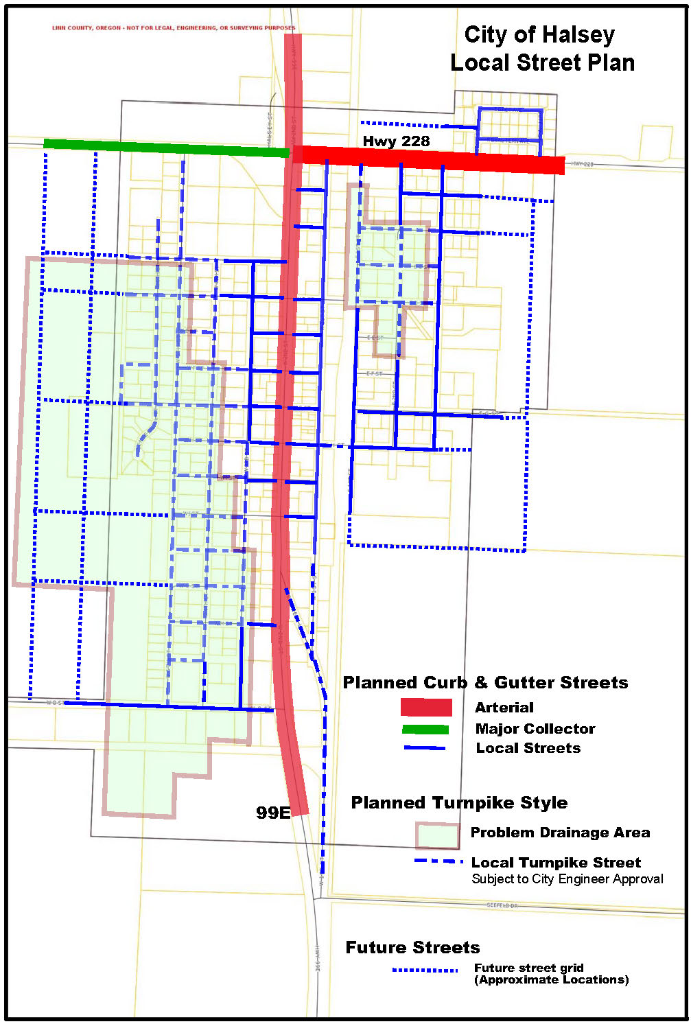
b. Street stubs shall be provided to allow access to abutting vacant or developable land and shall be designed to facilitate future extension of the street.
c. Street ends shall contain turnarounds constructed to Uniform Fire Code standards. Temporary turnarounds (e.g., hammerhead or bulb-shaped configuration) shall be constructed for stub streets over 150 feet in length.
d. Temporary barricade(s) shall be constructed at the end of the street by the developer and shall not be removed until authorized by the City or other applicable agency with jurisdiction over the street.
E. Formation of Blocks. In order to promote efficient vehicular and pedestrian circulation, subdivisions and site developments shall be served by an interconnected street network complying with the City’s block layout and orientation standards. Block distances are measured from the edge of street rights-of-way.
1. Residential District. Minimum of 200-foot block length and maximum of 600-foot length;
2. Commercial District. Minimum of 200-foot length and maximum of 400-foot length, as provided by Section 2.3.140 – “Block Layout and Orientation”.
3. All Other Zones: Minimum of 200-foot length and maximum of 1,000-foot length.
F. Street Location, Alignment, Extension and Grades.
1. All new streets, to the extent practicable, shall connect to the existing street network and allow for the continuation of the existing block layout, to allow continuity of street alignments and to facilitate future development of vacant or redevelopable lands. Where the locations of planned streets are shown on the City of Halsey Local Street Plan, Figure 3.5.110.D, the development shall be designed to implement the street(s) shown on the plan.
2. Specific street locations and alignments shall be determined in relation to existing and planned streets, topographic conditions, public convenience and safety, and in appropriate relation to the proposed use of the land to be served by such streets.
3. Grades of streets shall conform as closely as practicable to the original (pre-development) topography to minimize grading.
4. Existing street-ends that abut a proposed development site shall be extended with the development, unless prevented by environmental or topographical constraints, existing development patterns, or compliance with other standards in this Code. In such situations, the applicant must provide evidence that the environmental or topographic constraint precludes reasonable street connection.
G. Intersections. Streets shall be located and designed to intersect as nearly as possible to a right angle (90 degrees). All legs of an intersection shall meet the above standard for at least 100 feet back from the point of intersection. No more than two streets shall intersect, i.e., creating a four-legged intersection, at any one point. Street jogs and intersection offsets of less than 200 feet are not permitted. Intersections shall be designed to facilitate storm water runoff into approved storm water facilities.
H. Rights-of-Way Width and Street Cross-Sections. The standards contained in Table 3.5.110.H are intended: to provide for streets of suitable location, width, and design to accommodate expected vehicle, pedestrian, and bicycle traffic; to afford satisfactory access to law enforcement, fire protection, sanitation, and road maintenance equipment; and to provide a convenient and accessible network of streets, avoiding undue hardships to adjoining properties. Where a range of street width or improvement options is indicated, the decision authority, in consultation with the City Engineer, shall determine requirements based on the following factors:
1. Street classification and requirements of the roadway authority, if different than the City’s street classifications and requirements;
2. Existing and projected street operations relative to applicable standards;
3. Safety of motorists, pedestrians, bicyclists including consideration of accident history;
4. Convenience and comfort for pedestrians and bicyclists;
5. Provision of on-street parking;
6. Placement of utilities;
7. Street lighting;
8. Slope stability, erosion control, and minimizing cuts and fills;
9. Surface water management and storm drainage requirements;
10. Emergency vehicles or apparatus and emergency access, including evacuation needs;
11. Transitions between varying street widths (i.e., existing streets and new streets); and
12. Other factors related to public health, safety, and welfare.
Table 3.5.110.H
Street Design Standards for the City of Halsey
|
Type of Street |
Figure # |
Ave. Daily Trips |
Right of Way Width |
Pavement Width |
Travel Lanes |
Median |
Bike Lane |
On-street Parking |
Planting Strip |
Sidewalks |
|---|---|---|---|---|---|---|---|---|---|---|
|
Minor Arterial Hwy 99E |
5 |
>2,500 |
100’ |
62’ – 70’ |
(2) 11’ lanes |
12’ planted |
(2) 6’ lanes |
8’-12- bays or diagonal both sides |
8’-12’ both sides |
5’ – 12’ both sides |
|
Collector – Curbed Com/Ind Street |
4 or 6 |
500-2,500 |
60’ |
34’-40’ |
(2) 10’ lanes |
None |
(1) 6’ lane option |
(2) 7’ lanes or diagonal one side |
5’-8’ feet both sides |
5’ both sides |
|
Minor Arterial Collector – Curbed Street |
3 |
500 – 2,500 |
60’ |
34’- 40’ |
(2) 10’ lanes |
None |
(1) 6’ lane |
(2) 7’ lanes |
5’-8’ feet both sides |
5’ both sides |
|
Minor Arterial Collector – Turnpike Street |
4 |
500 – 2,500 |
60’ |
34’- 40’ |
(2) 10’ lanes |
None |
(1) 6’ lane option |
(2) 7’ lanes |
5’-8’ grassy swales |
5’ both sides |
|
Local – Curbed Street |
1 |
<500 |
60’ |
28’ – 32’ |
(2) 7’ – 9’ lanes |
None |
None |
7’ lanes both sides |
9’- 11’ both sides |
5’ both sides |
|
Local Turnpike Street |
2 |
<500 |
60’ |
28’ – 32’ |
(2) 7’ – 9’ lanes |
None |
None |
7’ lanes both sides |
9’ – 11’ grassy swales |
5’ both sides |
|
Cul-de-sac |
None |
<1000 |
50’ |
32’-36’ Bulb radius = 48’ |
(2) 7’-10’ lanes |
None |
None |
7’ lanes both sides |
None |
5’ both sides |
|
Alleys |
None |
<250 |
20’ |
12’-16’ |
(1) 12’ – 20’ |
None |
None |
None |
None |
None |
|
Pathways |
7 |
NA |
20’-30’ |
6’-12’ |
NA |
NA |
NA |
NA |
NA |
NA |
|
• Tree wells are allowed in the Commercial District or when approved by the Planning Commission • For a map of recommended locations of turnpike streets, please see Figure 3.5.110.D – City of Halsey Local Street Plan |
||||||||||
* All streets shall be improved in accordance with the construction standards and specifications of the applicable roadway authority, including requirements for pavement, curbs, drainage, striping, and traffic control devices. Where a park strip is provided it shall consist of a minimum 4’ to 8’ wide strip between the sidewalk and the curb or roadway. Where a swale is provided, it shall either be placed between the roadway and sidewalk or behind the sidewalk on private property, subject to City approval and recording of required public drainage way and drainage way maintenance easements. Streets with parking on one side only should be avoided. When used, they must be posted NO PARKING.
Figure 3.5.110.H (1) – Local Street Section: Curbed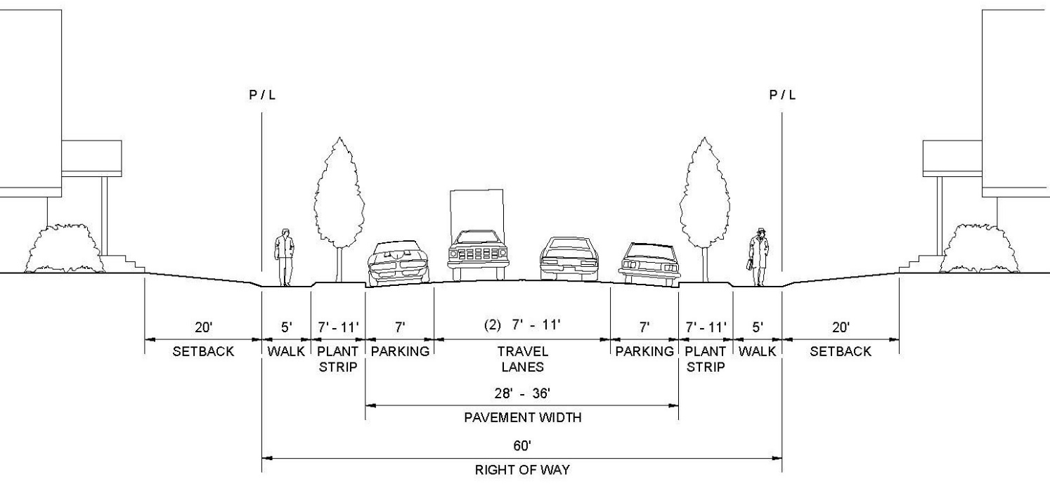
Figure 3.5.110.H (2) – Local Street Section: Turnpike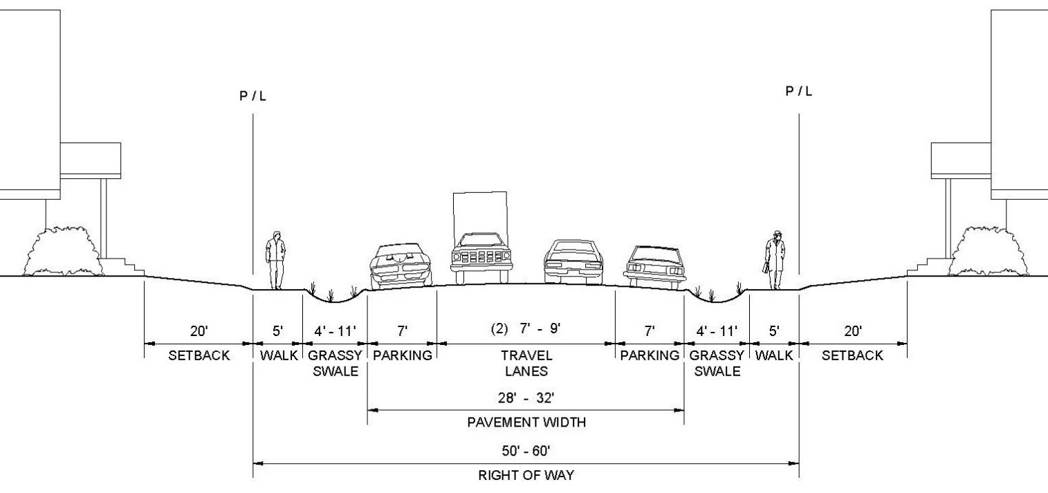
Note: As described in the City of Halsey Storm Drainage System Master Plan, certain areas of the City would be better served by streets without a piped drainage system (“turnpike” streets) due to existing elevation differences between streets and adjacent properties. Locations of the problem drainage areas are shown on the City of Halsey Future Street Plan Map, Figure 3.5.110.D. Where on-site investigation confirms this situation, the turnpike street design may be used.
Figure 3.5.110.H (3) – Linn County Roads Department
Turnpike Style - Minor Arterial & Major Collector
Contact the Linn County Roads Department for Design Standards on County Roads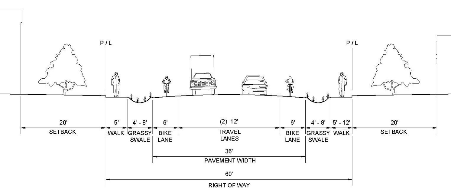
Figure 3.5.110.H (4) – Linn County Roads
Curbed Collector Street Section
Contact the Linn County Roads Department for Design Standards on County Roads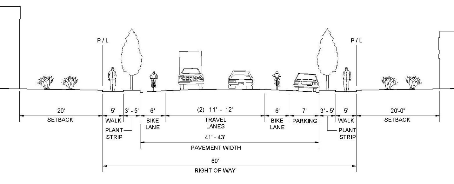
Figure 3.5.110.H (5) – ODOT Highway 99E
Curbed Minor Arterial – State Highway
Contact the Oregon Department of Transportation for Current Design Standards
Figure 3.5.110.H (6) -- Collector Street Section: Curbed (Commercial/Industrial District)
Diagonal Parking Option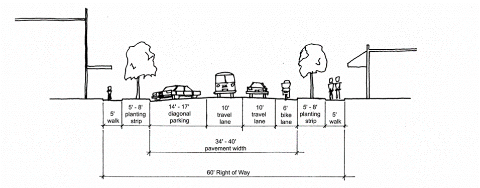
Figure 3.5.110.H (7) – City of Halsey
Pedestrian Path / Recreational Trail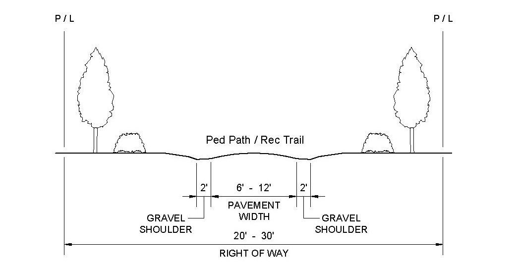
I. Substandard Existing Right-of-Way. Where an existing right-of-way adjacent to or within a proposed development is less than the standard width and/or if dedication is needed for a turn radius, the City may require the dedication of additional right-of-way at the time of subdivision, partition or site development pursuant to the standards in Table 3.5.110.H.
In cases where an existing street ROW width is less than the standard in Table 3.5.110.H, the City Administrator will consult with the City Engineer and determine if a ROW dedication will be required by the City. Findings in the development approval shall indicate how the required ROW dedication relates to and is roughly proportional to the impact of development.
The following streets need additional ROW:
• West 6th Street (North of West D Street)
• West 7th Street
• East A Street (East of East 3rd Street)
• East 3rd Street (North of East H Street)
• East H Street (East of East 3rd Street)
J. Dedication of Rights-of-Way for Streets and Related Purposes. Streets shall be created through the approval and recording of a final subdivision or partition plat; except the City may approve the creation of a street by acceptance of the deed. All deeds shall be in a form prescribed by the City and shall be accepted by the City Council.
K. Engineering Design Standards. Street design shall conform to the standards of the applicable roadway authority; for City streets that is the City of Halsey Public Works Design Standards. Where a conflict occurs between this Chapter and the City of Halsey Public Works Design Standards, the provisions of this Chapter shall govern.
L. Fire Code Standards. Where Fire Code standards conflict with City standards, the City shall consult with the local fire chief and/or the Fire Marshal in determining appropriate requirements. The City shall have the final determination regarding applicable standards.
M. Cul-de-sacs. A cul-de-sac street shall only be used where the Planning Commission determines that environmental or topographical constraints, existing development patterns, or compliance with other applicable City requirements preclude a street extension and through circulation. Where a cul-de-sac is allowed, all of the following standards shall be met:
1. The cul-de-sac shall not exceed a length of 400 feet, except where the Planning Commission determines that topographic or other physical constraints of the site require a longer cul-de-sac. The length of the cul-de-sac shall be measured along the centerline of the roadway from the near side of the intersecting street to the farthest point of the cul-de-sac.
2. The cul-de-sac shall not provide access to more than 12 dwelling units.
3. The cul-de-sac shall terminate with a circular or hammer-head turnaround complying with the Uniform Fire Code and the standards in Table 3.5.110.H.
4. The cul-de-sac shall provide, or not preclude the opportunity to later install, a pedestrian and bicycle access way between it and adjacent developable lands.
N. Half Streets. Half streets, while generally not acceptable, may be approved where essential to the reasonable development of the subdivision or partition, when in conformity with the other requirements of these regulations, and when the Planning Commission finds it will be practical to require the dedication of the other half when the adjoining property is divided. Whenever a half street is adjacent to a tract to be subdivided, the other half of the street shall be platted within such a tract. Reserve strips and street plugs may be required to preserve the objectives of half streets.
O. Streets Adjacent to Railroad Right-of-Way. Wherever the proposed development contains or is adjacent to a railroad right-of-way, a frontage street shall be created. New railroad crossings and modifications to existing crossings are subject to review and approval by Oregon Department of Transportation.
P. Development Adjoining Arterial Streets (Hwy 99E and Hwy 228). Where a development adjoins or is crossed by an arterial street, the development design shall separate residential access and through traffic and shall minimize traffic conflicts. The design shall include one or more of the following:
1. A parallel access street along the arterial with a landscape buffer separating the two streets;
2. Deep lots abutting the arterial to provide adequate buffering with frontage along another street. Double-frontage lots shall conform to the buffering standards in Section 3.3.130.E;
3. Screen planting along the arterial street property line to be contained in a non-access reservation (e.g., public easement or tract) along the arterial; or
4. Other treatment suitable to meet the objectives of this subsection;
5. If a lot has access to two streets with different classifications, primary access shall be from the lowest classification street, in conformance with Chapter 3.2, Section 3.2.120.D.
6. If access is proposed to a state highway or county road, the applicant will be required to obtain an ODOT and/or Linn County Roads Department access permit approval for the development.
Q. Private Streets. Private streets shall not be used to avoid connections with public streets. Gated communities (where a gate limits access to a development from a public street) are prohibited. Design standards for private streets shall conform to the standards in Table 3.5.110.H; and
R. Alleys, Public or Private. Alleys may be provided in commercial and industrial districts for access to off-street parking and loading facilities are approved by the Planning Commission. Alleys shall conform to the standards in Table 3.5.110.H. While alley intersections and sharp changes in alignment shall be avoided, the corners of necessary alley intersections shall have a radius of not less than 12 feet.
S. Reserve Strips. Reserve strips or street stubs controlling access to streets may be required when necessary to insure street extensions and the widening of half streets. The reserve strip shall normally be one foot in width and under the ownership of the City.
T. Access Easements. The City may approve an access easement established by deed when the easement is necessary to provide for access and circulation in conformance with Chapter 3.2 - Access and Circulation.
U. Sidewalks, Planter Strips, Bicycle Lanes. Except where the City grants a deferral of public improvements, sidewalks, planter strips, and bicycle lanes shall be installed concurrent with development. Maintenance of sidewalks and planter strips in the right-of-way is the continuing obligation of the adjacent property owner.
V. Curbs, Curb Cuts, Ramps, and Driveway approaches. Concrete curbs, curb cuts, wheelchair, bicycle ramps and driveway approaches shall be constructed in accordance with standards specified in Chapter 3.2 - Access and Circulation.
W. Traffic Calming. The City may require the installation of traffic calming features such as traffic circles, curb extensions, reduced street width (parking on one side), medians with pedestrian crossing refuges, speed tables, speed humps, or special paving to slow traffic in neighborhoods or commercial areas with high pedestrian traffic.
X. Traffic signals. Traffic signals shall be required with development when traffic signal warrants are met, in conformance with the Highway Capacity Manual, and Manual of Uniform Traffic Control Devices. The location of traffic signals shall be noted on approved street plans. Where a proposed street intersection will result in an immediate need for a traffic signal, a signal meeting approved specification shall be installed. The developer’s cost and the timing of improvements shall be included as a condition of development approval.
Y. Street Names. No street name shall be used which will duplicate or be confused with the names of existing streets in Linn County, except for extensions of existing streets. Street names, signs and numbers shall conform to the established pattern in the surrounding area, except as requested by emergency service providers.
1. East-West Streets. Streets south of Hwy 228 will be consecutively lettered “A” to “Z”.
2. North-South Streets. North-South streets south of Hwy 228 will be consecutively numbered.
3. Other Street Names. The Planning Commission may approve alternate street names at the time a subdivision is platted.
Z. Street Signs. The city, county or state with jurisdiction shall install all signs for traffic control and street names. The cost of signs required for new development shall be the responsibility of the developer. Street name signs shall be installed at all street intersections at the time street improvements are made. Stop signs and other signs may be required.
AA. Streetlight Standards. Streetlights shall be relocated or new lights installed, as applicable, with street improvement projects, at the sole cost of the developer. Streetlights shall conform to City standards or the requirements of the roadway authority, if different from the City.
AB. Mail Boxes. Mail boxes shall conform to the requirements of the United States Postal Service and the State of Oregon Structural Specialty Code. The developer is responsible for installation of mailboxes at the sole cost of the developer.
AC. Survey Monuments. Upon completion of a street improvement and prior to acceptance by the City, it shall be the responsibility of the developer’s registered professional land surveyor to provide certification to the City that all boundary and interior monuments shall be reestablished and protected.
AD. Final Pavement Lift Required Prior to City Acceptance. The final lift of asphalt or concrete pavement shall be placed on all new constructed public roadways prior to final City acceptance of the roadway unless otherwise approved by the City Engineer.
3.5.120 Public Parks and Open Space Areas
A. Purpose. The City of Halsey concludes it is good public policy to provide parks and recreational facilities to meet the needs of Halsey’s residents and visitors, enhance the livability of the City and make the City a great place to live and play. New subdivisions and larger residential developments are required to provide land for public parks, open spaces and/or greenways concurrently with the development provided the City makes findings to demonstrate consistency with constitutional requirements.
B. Land for Public Park, Open Space or Greenway. Any land division or site development plan for a residential development on a site larger than 5.0 gross acres in size shall designate an area of not less than 5% of the project site for a public park, open space or greenway.
1. Where the development site is adjacent to an existing public park, school, greenway, open space or publicly owned property and the City concludes the dedication is a logical addition to the existing public property, the City may require the dedication be contiguous to the existing public property.
2. Where a proposed public park, greenway or open space area is shown in a plan adopted by the City and is located on the development site, in whole or in part, the City may require the dedication or reservation of this area for public use.
C. Standard for Dedication of a Public Park, Greenway and/or Open Space. The park land dedication shall be proportional to the impact of the residential development project. Any required dedication shall be accompanied by findings made by the City to demonstrate consistency with constitutional requirements. The City concludes that a dedication of 5% of the gross land area of a development site is proportional to the demand for park land created by a new 5.0+-acre residential development.2
D. Dedication Requirements.
1. The City may require the dedication or reservation of the public park, open space or greenway as a condition of the development approval, if the city makes findings to demonstrate consistency with constitutional requirements.
2. If the dedication is part of a land division approval, the park area shall be dedicated on the final plat.
E. Acquisition of Additional Land by a Public Agency. The City, or another public entity, may purchase or accept voluntary dedication of an area of the development site, that is larger than the minimum area required by Section 3.5.120.B.
F. City Council Acceptance of Dedication. The City is under no obligation to accept an area proposed for dedication for a public park, greenway, open space or public use. The City Council will accept dedication of land in compliance with ORS 92.014 (2).
3.5.130 Sanitary Sewer and Water Service Improvements.
A. Sewers and Water Mains Required. All new development is required to connect to City water and sanitary sewer systems. Sanitary sewer and water system improvements shall be installed to serve each new development and to connect developments to existing mains in accordance with the adopted facility master plans and applicable City of Halsey Public Works Design Standards. Where streets are required to be stubbed to the edge of the subdivision, sewer and water system improvements and other utilities shall also be stubbed with the streets, except if an alternate alignment(s) is approved by the City Engineer which allows for extension beyond the applicant’s property.
B. Sewer and Water Plan approval. Development permits for sewer and water improvements shall not be issued until the City Engineer has approved all sanitary sewer and water plans in conformance with applicable standards adopted by the City.
C. Over-sizing. The City may require as a condition of development approval that sewer and water lines serving new development be sized to accommodate future development within the area as projected by the applicable facility master plans. The developer shall be entitled to the difference in material cost between the pipe size warranted by the development and the size required for oversizing or the City may authorize other cost-recovery or cost-sharing methods as provided under state law.
D. Inadequate Facilities. Development permits may be restricted by the City where a deficiency exists in the existing water or sewer system which cannot be rectified by the development and which if not rectified will result in a threat to public health or safety, surcharging of existing mains, or violations of state or federal standards pertaining to operation of domestic water and sewerage treatment systems. Building moratoriums shall conform to the criteria and procedures contained in ORS 197.505.
3.5.140 Storm Drainage
A. General Provisions. The City shall issue a development permit only where adequate provisions for storm water runoff have been made in conformance with the City of Halsey Storm Drainage Master Plan and the City of Halsey Public Works Design Standards.
B. Stormwater Analysis and Report. At the time a land use application is filed with the City for a land division or a site design review, the applicant shall provide a drainage impact analysis for City review, unless waived by the City Administrator. The analysis shall include a preliminary stormwater management plan, preliminary calculations, and a narrative which identifies the impacts the “new development” will have on existing stormwater systems. The narrative shall include the following:
1. A brief description of existing and developed conditions including net impervious surface area calculations.
2. The proposed facilities necessary to comply with the stormwater quality (pollutant reduction) requirements.
3. The proposed facilities necessary to comply with the stormwater quantity (flow control) requirements, including the preliminary pre-development and post-development stormwater runoff flow rates.
4. The method of discharging stormwater offsite and any anticipated design provisions needed to control the velocity and direction of the discharge in order to minimize damage to receiving systems or water bodies.
5. A list of any federal or state permits required for the project.
C. Accommodation of Upstream Drainage. Culverts and other drainage facilities shall be large enough to accommodate potential runoff from the entire upstream drainage area, whether inside or outside the development. Such facilities shall be subject to review and approval by the City Engineer.
D. Effect on Downstream Drainage. Where it is anticipated by the City Engineer that the additional runoff resulting from the development will overload an existing drainage facility, the City shall withhold approval of the development until provisions have been made for improvement of the potential condition or until provisions have been made for storage of additional runoff caused by the development in accordance with City public works standards.
E. Existing Watercourses. Where a development is adjacent to or traversed by a watercourse, drainage way, channel or stream, the City may require the property owner to provide a storm water easement or drainage right-of-way. The easement or right-of-way width shall conform with the lines of the water course, with such further width as is recommended in the City of Halsey Storm Drainage System Master Plan or as recommended by the City Engineer to protect public health and safety. The easement or right-of-way width shall be established to assure ease of channel maintenance, to accommodate possible flooding, to assure that the channel will not be encroached upon by fences and other improvements, and where feasible, to encourage multiple use of the drainage channel and related area for purposes such as utility strips, transportation corridors for bicycle or pedestrian use, or as natural greenways. Specifications for widths and improvements for water courses are contained in the city public works design standards.
F. Design. The design of storm drainage facilities shall conform to the recommendations contained in the Storm Drainage System Master Plan. These include turnpike (no curbs, open drainage) streets in some areas of the city. The City Engineer shall approve the proposed drainage system for all developments.
G. Over-Sizing. The City may require as a condition of development approval that storm drainage systems serving new development be sized to accommodate future development within the area as projected by the applicable facility master plan.
H. Maintenance of Storm Water Management Facilities. The property owner is responsible for the on-going operation and maintenance of all private on-site storm sewers, drainage facilities, storm water retention/detention basins and water quality facilities and for the continuous maintenance of any storm drainage channel or water course that traverses the property.
I. Flood Plain. If the property is located in the 100-year flood plain, the applicant will obtain any required flood plain development permit and comply with the City’s flood plain management ordinance.
J. Storm Drainage Easements. If required, the developer shall provide on-site storm drainage easements and secure off-site storm drainage easements necessary to serve the development. See Section 3.5.160.
3.5.150 Utilities
The following standards apply to new development where the extension of electric power, natural gas or communication lines is required:
A. General Provision. The developer of a property is responsible for coordinating the development plan with the applicable utility providers and paying for the extension and installation of utilities not otherwise available to the subject property.
B. Underground Utilities.
1. General Requirement. The requirements of the utility service provider shall be met. All utility lines in new subdivisions, including, but not limited to, those required for electric, communication, and lighting, and related facilities, shall be placed underground, except where the Public Works Director or the City Engineer determines that placing utilities underground would adversely impact adjacent land uses. The City may require screening and buffering of above ground facilities to protect the public health, safety, or welfare.
2. Subdivisions. In order to facilitate underground placement of utilities, the following additional standards apply to all new subdivisions:
a. The developer shall make all necessary arrangements with the serving utility to provide the underground services. Care shall be taken to ensure that no above ground equipment obstructs vision clearance areas for vehicular traffic.
b. The City Engineer reserves the right to approve the location of all surface-mounted facilities.
c. All underground utilities installed in streets must be constructed and approved by the applicable utility provider prior to the surfacing of the streets.
d. Stubs for service connections shall be long enough to avoid disturbing the street improvements when service connections are made.
C. Exception to Undergrounding Requirement. The City Engineer or the Public Works Director, in consultation with the City Engineer, may grant exceptions to the undergrounding standard where existing physical constraints, such as geologic conditions, streams, or existing development conditions make underground placement impractical.
D. Easements for Utilities. The City or the utility provider may require the recording of a utility easement for a utility located on private property.
3.5.160 Easements
A. Provision. The developer shall make arrangements with the City and applicable utility service providers for the provision and dedication of utility easements necessary to provide full services to the development.
B. Standard. Utility easements shall conform to the requirements of the utility service provider. All other easements shall conform to the City of Halsey Public Works Design Standards. The City’s standard width for utility easements shall be 10’ unless otherwise specified by the utility service provider or the City Engineer.
C. Recordation. All easements for sewers, storm drainage and water quality facilities, water mains and private utilities shall be recorded in the Linn County Deed Records as a separate easement document and/or referenced on a survey or final plat, as applicable.
3.5.170 Construction Plan Approval and Assurances
A. Construction Plan Approval and Payment of Required Fees to the City. No development including sanitary sewers, water, streets, parking areas, buildings, or other development, shall be undertaken without plans having been approved by the City of Halsey, permit fees paid, and permits issued. Permit fees defray the cost and expenses incurred by the City for plans reviews, public works construction permit issuance, consultant and legal fees, inspections, utility installation and other services in connection with the improvement. The City of Halsey’s land use, public works and permit fees are set by City Council resolution.
B. Plan Approval by Other Agencies. The applicant is responsible for obtaining required permits and payment of fees to other government entities and agencies which have regulatory authority for the project. Upon request the developer will provide copies of approved permits to the City.
3.5.180 Facility Installation
A. Conformance Required. Improvements installed by the developer either as a requirement of these regulations or at the Developer’s option, shall conform to the requirements of this Chapter, approved construction plans, and to improvement standards and specifications adopted by the City.
B. Adopted Installation Standards. The Standard Specifications for Public Works Construction, Oregon Chapter A.P.W.A. shall be a part of the City’s adopted installation standard(s); other standards may also be required upon recommendation of the City Engineer.
C. Commencement. Work in a public right-of-way shall not begin until all applicable agency permits have been approved and issued. The City will be notified at least 24-hours in advance of the start of work.
D. Resumption. If work is discontinued for more than six months, it shall not be resumed until the City Engineer and/or the Public Works Director is notified in writing and the City grants written approval for the work to resume.
E. City Inspection. Improvements shall be constructed under the inspection of the Public Works Director or the City Engineer. The Public Works Director or City Engineer may approve minor changes in typical sections and details if unusual conditions arising during construction warrant such changes in the public interest. Modifications requested by the developer shall be subject to land use review under Chapter 4.6 - Modifications to Approved Plans and Conditions of Approval. Any survey monuments that are disturbed before all improvements are completed by the developer or subdivider shall be replaced prior to final acceptance of the improvements.
F. Engineer’s Certification and As-Built Plans.
1. Engineer’s Certification of Completion. A registered civil engineer shall provide a letter to the City certifying that all improvements, workmanship, and materials have been completed and are in accord with current and standard engineering and construction practices, conform to approved plans and conditions of approval, prior to City’s acceptance of the public improvements, or any portion thereof, for operation and maintenance.
2. As-Built Plans. The developer’s engineer shall provide electronic files (AutoCAD and/or .pdf) and two printed sets of “as-built” plans for permanent filing with the City of Halsey Public Works Department and the City Engineer, unless otherwise directed by the City Engineer.
3. Warranty Bond. If required by the City, the developer or subdivider shall provide a warranty bond pursuant to Section 3.5.190.
3.5.190 Performance Guarantee and Warranty
A. Performance Guarantee Required. The City at its discretion may approve a final plat or building permit when it determines the public improvements required for the site development or land division, or phase thereof, are complete or the applicant has provided the City with a financial security which guarantees the completion of the required improvements. When required by the City, the applicant shall provide a performance bond issued by a surety authorized to do business in the state of Oregon, irrevocable letter of credit from a surety or financial institution acceptable to the City, cash, or other form of financial security acceptable to the City.
B. Determination of Sum. The assurance of performance shall be for a sum determined by the City Engineer as required to cover the cost of the improvements and repairs, including related planning, legal and engineering review and inspection costs, plus incidental expenses and reasonable inflationary costs. The assurance shall not be less than [125%] percent of the estimated improvement costs.
C. Itemized Improvement Estimate. The applicant shall furnish to the City an itemized improvement estimate, certified by a registered civil engineer, to assist the City in calculating the amount of the performance assurance.
D. Agreement. A written agreement between the City and applicant shall be signed and the City may require the agreement be recorded in the County Deed Records, as a deed covenant on the real property. The agreement may include a provision for the construction of the improvements in stages and for the extension of time under specific conditions. The agreement shall contain all of the following:
1. The period within which all required improvements and repairs shall be completed;
2. A provision that if work is not completed within the period specified, the City may complete the work and recover the full cost and expenses from the developer;
3. The required improvement fees and deposits or performance guarantee. The amount shall be sufficient to cover all costs in Section 3.5.190.B.
E. When Applicant Fails to Perform. In the event the applicant fails to carry out all provisions of the agreement and the City has unreimbursed costs or expenses resulting from such failure, the City shall call on the bond, cash deposit, or letter of credit for reimbursement.
F. Termination of Performance Guarantee. The applicant shall not cause termination, nor allow expiration, of the guarantee without first securing written authorization from the City.
G. Warranty Bond. A warranty bond good for one year is required on all public improvements and landscaping when installed in the public right-of-way. The warranty bond shall equal [30] percent of the total cost of improvements and begin upon acceptance of said improvements by the City.
City of Halsey Public Works Design Standards, dated 1996.
Standard for Park Land, Open Space and/or Recreational Trail Dedication: The Oregon State Parks Department recommends Oregon cities provide 6.25 to 12.00 acres of park land per 1,000 residents. The City of Halsey has established a standard 6.0 acres of land for public parks, open space or greenway per 1,000 residents. The City finds the dedication of 5% of a residential development site will not fully meet the City’s 6.0 acres per 1,000 residents standard, but will provide additional park land in an amount that is roughly proportional to the impact created by the new residential development. The following examples show how to calculate the minimum amount of park land dedication to be included on a residential development site of 5 acres in size or larger.
Example #1: Proposed subdivision on a 15-acre site @ 4 units/acre net density = 60 new homes.
60 single-family homes @ 3.00 persons per household = 180 residents
180 / 1000 residents = 18% x 6.0 acres/1,000 residents = 1.08 acres of parkland.
The analysis shows 1.08 acres of park land is needed to serve 180 residents in the subdivision.
Section 3.5.120 requires a park land dedication of 0.75 acres (5% of the 15-acre project site).
Example #2: Proposed apartment complex on a 5-acre site @ 12 units/acre density = 60 new units
60 multi-family apartment units @ 2.5 persons per household = 150 estimated residents
150 / 1000 residents = 15% x 6 acres/1000 residents = 0.90 acres of parkland is needed.
The analysis shows 0.90 acres of park land is needed to serve 150 residents in the complex.
Section 3.5.120 requires a park land dedication of 0.25 acres (5% of the 5-acre project site).