


Chapter 17.54
NORTH END WENATCHI LANDING OVERLAY
Sections:
17.54.050 Dimensional standards.
17.54.060 Design and development standards.
17.54.010 Purpose.
The purpose of the North End Wenatchi Landing (NEWL) overlay district is to establish a prosperous center for job-creating industry and a tourist and recreation destination at the north end of East Wenatchee consistent with the North End Master Site Plan and the Greater East Wenatchee Area Comprehensive Plan. Primary uses include resort/hospitality, business park, wine village, office, institutional, retail, and commercial recreation. Development will create an employment and mixed-use waterfront center that is vibrant and attractive and that is supported by efficient and effective infrastructure. The NEWL overlay district supports the planned action adopted for the overlay zone area to reduce the expense and time of permitting for development that meets the plan vision. (Ord. 20-13 § 7 (Exh. B), 2020)
17.54.020 Applicability.
This overlay zone applies to the lands north and south of Odabashian Bridge along the Columbia River in East Wenatchee’s northern urban growth area and addressed in the North End Master Site Plan. (Ord. 20-13 § 7 (Exh. B), 2020)
17.54.030 Permitted uses.
A. See Chapter 17.34 EWMC for a matrix of permitted, accessory and conditional uses allowed in the NEWL overlay district.
B. All uses considered a qualifying land use in Attachment D of Planned Action Ordinance TLS 16.09-37C approved by Douglas County [City of Wenatchee Ordinance 2016-16] are considered permitted uses.
C. Residential and mixed uses shall conform to either subsection (C)(1), (C)(2), or (C)(3) of this section. All such uses shall comply with subsection (C)(4) of this section.
1. Option 1: Vertical Mixed Uses on Primary Streets, Commercial and/or Residential Elsewhere.
a. Residential multifamily dwelling units are permitted when part of a mixed-use development subject to:
i. The ground floor of buildings along primary street frontages shall have a minimum floor-to-ceiling height of 15 feet.
ii. The ground floor of buildings along primary street frontages shall have occupiable commercial space at 30 feet in depth.
b. A minimum of 50 percent of ground floor area shall be oriented to the primary street frontage of the property and shall contain active commercial uses that draw customers (e.g., retail, restaurants, or on-site services). The director may allow other nonresidential uses, such as a fitness room of an apartment complex in the required ground floor commercial space, as an accessory use. Vertical mixed use shall consist of nonresidential uses on the ground floor and living units above; live-work units are considered vertical mixed uses.
c. Stand-alone residential uses are not allowed on the primary street frontages. Stand-alone residential is permitted on secondary street frontages.
d. The proponent of a multiple phased development including residential uses shall provide a phasing plan. The phasing plan shall provide for the completion of residential and employment uses as follows:
|
Use Type |
First Phase |
Second Phase |
Later Phases |
|---|---|---|---|
|
Residential |
Up to 50% of units max.1 |
Up to 75% of units max.1 |
Up to 100% of units max.1 |
|
Employment |
Any amount1 |
At least 25% of planned space2 |
At least 50% of planned space at time residential is completed2 Following completion of residential up to 100% of space max. |
Notes:
1 Along primary street frontages, mixed-use ground floor space shall at least meet the dimensions of subsection (C)(1)(a) of this section.
2 Along primary street frontages, ground floor space shall provide for active uses per subsection (C)(1)(b) of this section.
e. The following diagram illustrates the intent of Option 1. The text shall control over the diagram in cases of interpretation.
Figure 17.54.030-1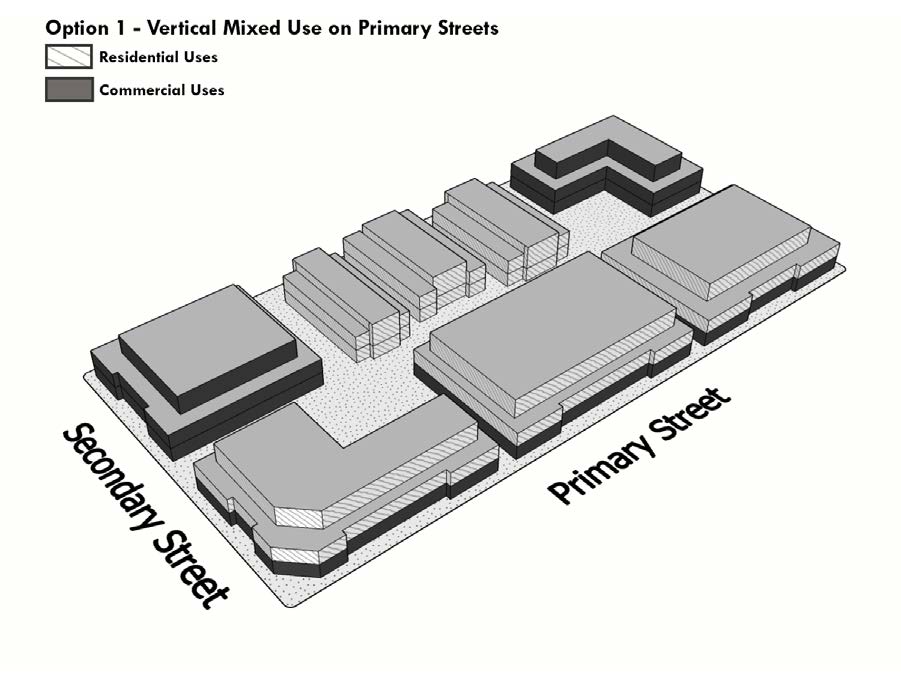
2. Option 2: Horizontal Mixed Uses Allowed.
a. Stand-alone residential is allowed as part of an integrated mixed-use development where residential uses are in separate structures from nonresidential uses; provided, that:
i. The minimum share of commercial space in the total development is at least 30 percent, and phasing plans shall meet Table 17.54.030-2;
ii. A site plan is prepared by the applicant that is consistent with EWMC 17.54.060 and the following criteria:
(A) The site plan illustrates that the horizontal mixed use development has coordinated on-site landscaping, paths and trails, plazas and recreation areas, circulation, access, and parking between the uses; and
(B) The site plan and elevations demonstrate building design of residential and nonresidential spaces that are compatible in height, bulk, massing, rooflines, orientation, and materials.
b. The proponent of a multiple phased development including residential uses in a horizontal mixed-use pattern shall provide a phasing plan. The phasing plan shall provide for the completion of residential and employment uses as follows:
|
Use Type |
First Phase |
Second Phase |
Later Phases |
|---|---|---|---|
|
Residential |
Up to 50% of units max.1 |
Up to 75% of units max.1 |
Up to 100% of units max.1 |
|
Employment |
Any amount1 |
At least 25% of planned space |
At least 50% of planned space at time residential is completed Following completion of residential up to 100% of space max. |
Note:
1 A minimum of 50 percent of any commercial ground floor area located on a primary street shall be oriented towards the street frontage.
c. The following diagram illustrates the intent of Option 2. The text shall control over the diagram in cases of interpretation.
Figure 17.54.030-2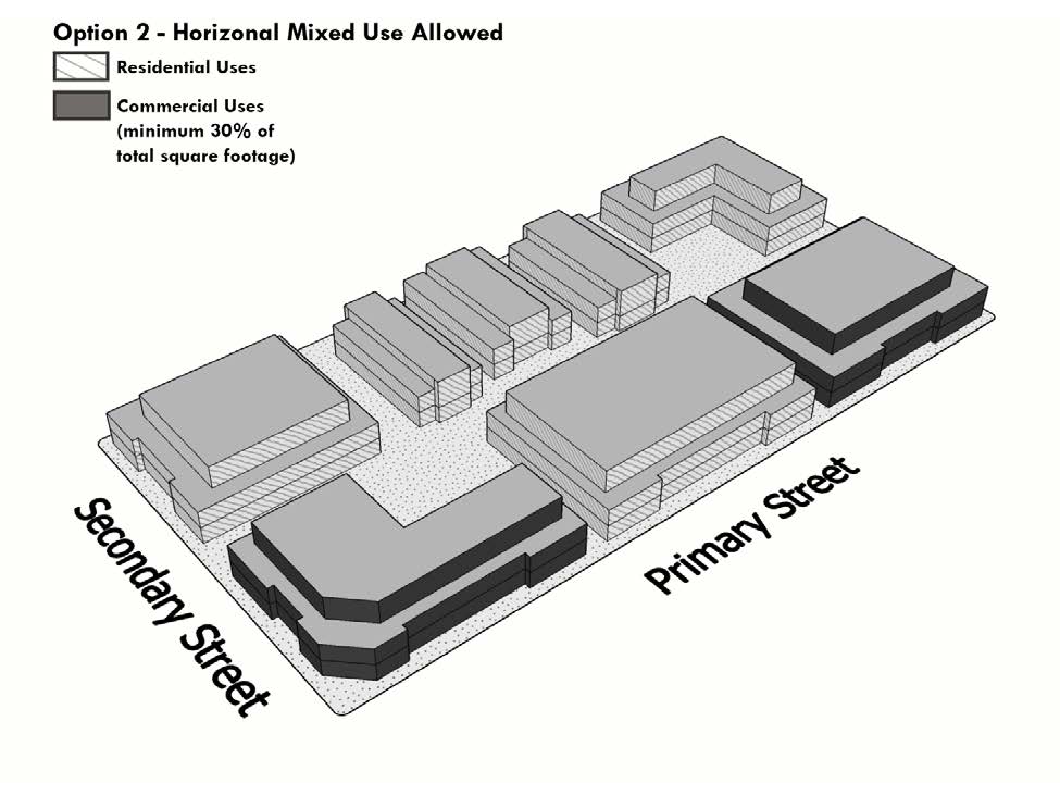
3. Option 3: All Vertical Mixed Use.
a. Residential Multifamily Dwelling Units are permitted when part of a mixed-use development subject to:
i. The ground floor of buildings along any street frontage shall have a minimum floor-to-ceiling height of 15 feet.
ii. The ground floor shall have occupiable commercial space at 30 feet in depth along any street frontage.
iii. A minimum of 50 percent of ground floor area shall be oriented to the primary street frontage of the property and shall contain active commercial uses that draw customers (e.g., retail, restaurants, or on-site services). The director may allow other nonresidential uses, such as a fitness room of an apartment complex in the required ground floor commercial space, as an accessory use.
iv. Stand-alone residential uses are not allowed.
b. The following diagram illustrates the intent of Option 3. The text shall control over the diagram in cases of interpretation.
Figure 17.54.030-3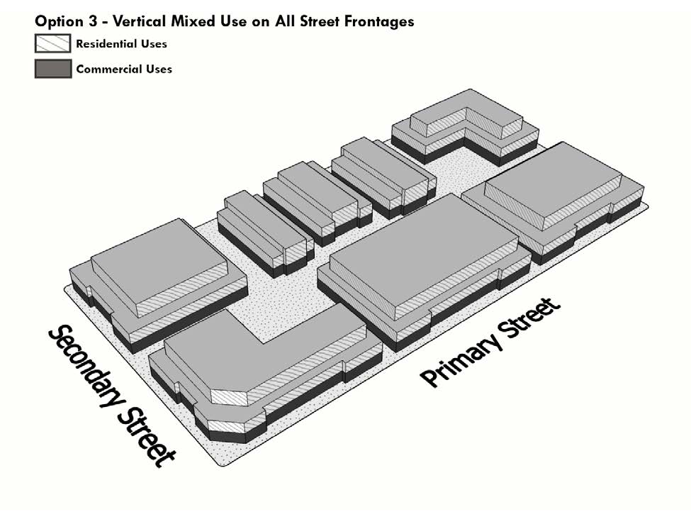
4. For the purposes of Options 1 through 3 above, primary street frontages shall include roads and road extensions classified as collectors or higher. (Ord. 20-13 § 7 (Exh. B), 2020)
17.54.040 Prohibited uses.
All uses not listed as permitted uses, accessory uses, or conditional uses in EWMC 17.54.030 shall be prohibited uses. Upon application to the hearing examiner, the hearing examiner may rule that a use not specifically named in the permitted uses of a district shall be included among the allowed uses if the use is of the same general type and is similar to the permitted uses; however, this section does not authorize the inclusion of a use in a district where it is not listed when the use is specifically listed in another district. (Ord. 20-13 § 7 (Exh. B), 2020)
17.54.050 Dimensional standards.
A. Dimensional standards of the underlying base zone shall apply except as included in this section.
B. Minimum Floor Area Ratio. The minimum floor area ratio for a single purpose use shall be no less than 0.5, and for a mixed-use development no less than 0.75.
C. Mixed-Use Residential Density. Residential uses as part of a mixed-use development shall not exceed 24 dwelling units per acre. The number of dwellings shall be consistent with the residential space evaluated in the Planned Action Ordinance TLS 16.09-37C approved by Douglas County [City of Wenatchee Ordinance 2016-16]. (Ord. 20-13 § 7 (Exh. B), 2020)
17.54.060 Design and development standards.
A. Procedures. Project permit applications shall submit a project narrative that demonstrates consistency with design and development standards of this section and the underlying base zone, together with required submittal materials pursuant to EWMC Title 19. The community development director shall determine consistency using the provisions of this code, the North End Master Site Plan, and the Greater East Wenatchee Area Comprehensive Plan.
B. Greater East Wenatchee Urban Area Design Standards and Guidelines. All project permit applications shall demonstrate consistency with the Greater East Wenatchee Urban Growth Area Design Standards and Guidelines in effect at the time of application.
C. All project permit applications shall demonstrate consistency with urban design principles site planning and circulation in the Master Site Plan Section 3.2, Exhibit 3.2 1. Design Principles. The applicant is responsible to implement the design principle unless there is a demonstrated, compelling reason that it cannot be accomplished such as inapplicability, infeasibility, legal requirements, or other factors. If the principle is required under another applicable local, state, or federal law or standard, it shall be implemented.
D. General Commercial Buffer. In the portions of the study area zoned general commercial, all project permit applications shall provide a 50-foot transition buffer along the southern boundary of the study area. The buffer area shall include Type I landscaping screening along any property line that abuts residential zoning, consistent with Section 20.40.030 of the Douglas County Code or EWMC 17.72.080, depending on the agency with jurisdiction. The landscaped area may be used for any of the following features:
1. Stormwater detention, infiltration, or conveyance ponds or swales;
2. Bicycle and pedestrian trail features that form part of an on-site nonmotorized circulation system;
3. Programmed open space, including lawn or park areas, gardens, and orchards; or
4. Passive open space, including native vegetation protection or habitat enhancement.
E. Transition Standards. To reduce adverse visual effects where higher intensity development abuts lower intensity development, all development in the NEWL overlay located on property that abuts a residential zone, but which is not subject to the general commercial buffer requirement established in subsection D of this section, shall apply two or more of the following transition design standards:
1. Within 50 feet of residential zoning, limit building heights to 35 feet;
2. Provide a Type I landscaping buffer, as defined by Section 20.40.030 of the Douglas County Code or EWMC 17.72.080, along any property boundary that abuts a residential zone;
3. Provide a decorative screening wall or fence, at least six feet in height, along any property boundary that abuts a residential zone;
4. Where a rear yard setback abuts a residential zone, increase the standard setback distance to 50 feet; or
5. Where a property boundary that abuts a residential zone is characterized by significant mature native vegetation, preserve such vegetation and implement a building setback of at least 20 feet.
F. Streets and Sidewalks.
1. All public streets shall be designed to incorporate sidewalks consistent with county and city street standards. Some street standards show a range of sidewalk widths. Where pedestrian activity is anticipated to be greatest, wider sidewalks should be implemented.
2. Arterial or collector streets shall accommodate bicycles consistent with adopted county and city road standards and adopted bicycle regional guidelines.
3. Properties abutting the Apple Capital Loop Trail or Rocky Reach Trail, or their spurs, shall be consistent with the Chapter 17.50 EWMC, LT-O Loop Trail Overlay District, including standards for fencing, trail access, landscaping, and setbacks from the trail.
4. The following on-site pedestrian walkway standards shall be met by each development:
a. A comprehensive system of pedestrian walkways shall link together all site entrances, building entries, parking facilities, and common outdoor spaces with the sidewalk system in the public right-of-way.
b. Pedestrian walkways shall be reinforced with pedestrian-scale lighting, bollard lighting, landscaping, accent lighting, signage, or a combination thereof to aid in pedestrian way-finding.
c. Each parcel shall provide pedestrian walkways that provide for connections from public rights-of-way through the subject property to the regional trail system that, when connected with other properties, will facilitate east-west travel to and from the regional trail system. For every 1,320 feet of street frontage, on average, a pathway to the regional trail system shall be provided. The walkway must connect with walkways located on other properties established in accordance with this condition. Distances may vary from exactly 1,320 feet to accommodate linking adjacent developments on a case-by-case basis.
5. All new utilities within the right-of-way shall be installed underground. All existing overhead utilities within the right-of-way shall be relocated underground at the time of development of the fronting property unless otherwise approved in writing by the county engineer. (Ord. 20-13 § 7 (Exh. B), 2020)
17.54.070 Interpretation.
A. All regulations of the underlying zoning district or any other applicable overlay district not specifically addressed in this chapter apply to lands in the NEWL overlay district; provided, however, that in the case of conflict between the provisions of the underlying zoning district, the NEWL overlay requirements shall control.
B. Where there are inconsistencies between the municipal code and the planned action ordinance, the planned action ordinance shall control.
C. The community development director shall use the vision, principles, policies, and plans contained in the North End Master Site Plan and the Greater East Wenatchee Area Comprehensive Plan to:
1. Interpret the meaning of applicable codes to a development application.
2 Evaluate the suitability of a use identified as a conditional use permit in Chapter 17.34 EWMC. (Ord. 20-13 § 7 (Exh. B), 2020)