


Chapter 19.80
SDD/R – SPECIAL DEVELOPMENT DISTRICT/RESIDENTIAL
Sections:
19.80.040 Relationship of uses.
19.80.060 Dimensional requirements.
19.80.070 Recreational requirement.
19.80.080 General design criteria.
19.80.090 Public improvements.
19.80.110 Parking requirements.
19.80.180 Use of concomitant agreement.
19.80.190 Submittal requirements – Preliminary site plan.
19.80.200 Planning Commission review – Preliminary site plan.
19.80.210 City Council preliminary approval.
19.80.220 Effect of preliminary approval.
19.80.230 Preliminary approval period.
19.80.240 Final submittal and review.
19.80.260 Final approval period.
19.80.270 Modifications to final plan.
19.80.280 Special regulations.
19.80.010 Purpose and intent.
The Special Development District is designed to promote the following purposes:
A. To implement the goals, policies, and objectives of the City’s Comprehensive Plan;
B. To encourage a total development concept of a large area, rather than small ununified parcels creating a piecemeal effect;
C. To promote uses which will be aesthetically complimentary to the community;
D. To minimize negative impacts on surrounding residential neighborhoods and existing economic activity;
E. To promote development that is sensitive to the environment; and
F. To provide for a Special Development District with a residential emphasis which is separate and distinct from Special Development District Commercial/Residential (SDD C/R) which can have commercial uses, personal service shops, professional offices, medical clinics, and residential uses as primary uses. (Amended by City request, 1/11; Ord. 2104, 1996; Ord. 2074 § 4.16(A), 1995).
19.80.020 Primary uses.
Residential uses, which include:
1. Single households or any use permitted in the RS 8400 zone as regulated therein;
2. Town houses;
3. Multiple-household residences;
4. Nursing homes, retirement centers, congregate care facilities. (Ord. 2104, 1996; Ord. 2074 § 4.16(B), 1995).
19.80.030 Secondary uses.
1. Personal service shops;
2. Professional offices;
3. Medical clinics;
4. Such other uses which the Planning Commission determines to be in keeping with the intent of this classification and through proper controls and standards of operation will conform to the intent of this classification. (Ord. 2104, 1996; Ord. 2074 § 4.16(C), 1995).
19.80.040 Relationship of uses.
Primary uses as stated are intended to determine the overall character of the property. At least one primary use must be developed and under construction prior to or concurrently with any secondary uses. Preference should be given to secondary uses which provide complementary or supportive services to primary uses. Other permitted secondary uses should enhance the overall site design of the property. Secondary uses shall not be permitted in areas where such uses would adversely impact adjacent residential areas or where natural site conditions such as poor soils or steep slopes would restrict adequate circulation or access and egress. (Ord. 2104, 1996; Ord. 2074 § 4.16(D), 1995).
19.80.050 Prohibited uses.
1. Sexually oriented adult businesses/adult entertainment establishments;
2. Liquor licenses;
3. Retail;
4. Manufacturing;
5. Warehouses;
6. Wholesale. (Ord. 2104, 1996; Ord. 2074 § 4.16(E), 1995).
19.80.060 Dimensional requirements.
A. Minimum Size.
1. Twenty-Five Acres. The 25-acre minimum refers to the amount of land which must be included in a site development plan. Actual construction may occur in smaller parcels when a phasing plan has been submitted and approved as provided for in MTMC 19.80.170.
2. Single-household detached residences are permitted on 8,400 square feet lots.
B. Density.
1. Maximum: 12 units per acre;
2. Densities may be transferred or clustered within the project site if undertaken in a manner which will improve or benefit natural site conditions and meet all other conditions of this chapter.
3. Acreage used for secondary uses does not contribute or transfer towards higher residential densities.
4. Actual density approved may be less than 12 units per acre due to on-site conditions relating to soils, trees, creeks, topography, or other natural features, or where it is in the public interest to limit development due to the lack or inadequate level of community services or access to the site, or impacts associated with the implementation of a proposed development plan.
C. Impervious Surface.
1. Maximum: 50 percent total lot area;
2. Maximum impervious surface area may be increased to 55 percent of the total lot area, subject to submittal by an applicant of an update or amendment to any applicable drainage plan and found acceptable by the City Council. The applicant shall be responsible for the cost of any revisions necessary to the design documents of any applicable drainage facilities.
D. Building Height.
1. Maximum: 35 feet;
2. Additional height may be allowed for buildings which are to be constructed against a hillside and which have minimal or no impact on views from surrounding properties, as determined by the Planning Commission.
E. Floor Area Limitations.
1. Total floor area of uses other than residential or noncommercial recreational may not exceed 15,000 square feet.
2. The permitted floor area may be increased to 10 percent of the project’s total residential floor area subject to submission of a market study found acceptable to the City, which substantiates the demand for the proposal. The market feasibility study shall show that the demand exists within a realistic trade area and without detriment to other such uses within the City of Mountlake Terrace.
F. Minimum distance between buildings (except for accessory structures): 15 feet.
G. Minimum Setbacks:
1. Arterial: 30 feet;
2. Nonarterial: 20 feet. (Amended by City request, 1/11; Ord. 2104, 1996; Ord. 2074 § 4.16(F), 1995).
19.80.070 Recreational requirement.
The developer will be required to provide noncommercial recreational facilities which relate to the physical scale of the project as well as the anticipated needs of the residents.
Requirements for recreational investment are per MTMC 19.35.070(G)(2).
Open space and private balconies shall not be considered as recreational area.
Noncommercial recreational facilities shall be operated on a not-for-profit basis for the use of residents of the development and their guests. Such facilities may include, but are not limited to: Sport courts, swimming pools, spas, golf courses, and game rooms. (Ord. 2104, 1996; Ord. 2074 § 4.16(G), 1995).
19.80.080 General design criteria.
A. Development design should provide for a safe living environment by providing reasonable emergency access, numbering of buildings, lighting of parking areas, pathways, and door entrances to each unit. Restrict parking in aisles or near fire hydrants providing, where feasible, some wide paved pathways to the interior of a project to allow emergency vehicles to respond closer to individual buildings. Avoid long dead-end streets or drives and provide for adequate turning area on dead-end routes.
B. The development should visually harmonize with its surroundings and offer potential for enhancing the value of surrounding property.
C. The development should have an integrated design which is visually and architecturally compatible. Complete specifications of all exterior elevations and exterior building materials must be provided for review by the Planning Commission. Any modifications or deviations from approved plans must be resubmitted for review and approval.
Nonresidential uses should be limited in size and service to facilities which relate principally to the project.
Nonresidential uses in the development project should not be designed to dominate surrounding residential uses by incorporating oversized advertising signs, intense lighting, increased building height, or other devices which focus attention on location. (Ord. 2104, 1996; Ord. 2074 § 4.16(H), 1995).
19.80.090 Public improvements.
All public improvements, including utilities, curbs, gutters, streets, and sidewalks shall be installed by the developer according to standards set by the City Engineering Department.
Access to the project should be through the expansion and improvement of existing rights-of-way and in accordance with the Mountlake Terrace Comprehensive Transportation Plan. Where adequate engineering traffic and soils studies indicate an alternate circulation plan will better serve the projected demands, without overburdening or otherwise negatively impacting the community’s residents, public services, or environmental quality, the Planning Commission may recommend that the City Council approve such a plan. (Ord. 2104, 1996; Ord. 2074 § 4.16(I), 1995).
19.80.100 Landscaping.
The landscaping of the site should serve to soften the visual impact of the project on surrounding streets and residential areas, according to the following schedule. See Chapter 19.130 MTMC for a description of the landscape types.
Table of Minimum Landscaping Requirements
|
S.D.D. Land Use |
Abutting Land Use |
||
|
Single-Household Residential |
Multi-Household Residential |
Non-residential |
|
|
Single-Household Residential Detached |
None |
None |
None |
|
Single-Household Attached & Multi-Household Residential |
Type IV, 12' |
Type III, 10' |
Type IV, 12' |
|
Nonresidential* |
Type IV, 15' |
Type IV, 15' |
Type III, 8' |
*If any building contains or will contain any nonresidential use other than parking associated with residential units, then the nonresidential requirements shall apply.
All barren slopes should be seeded and planted to reduce erosion potential.
All other landscape requirements of Chapter 19.130 MTMC shall apply to the Special Development District including: irrigation, interior parking lot landscaping, plant materials, fences, hedges, and screening height limitations. (Ord. 2104, 1996; Ord. 2074 § 4.16(J), 1995).
19.80.110 Parking requirements.
Parking standards of Chapter 19.125 MTMC shall provide guidelines for projects in the Special Development District. Modification of these standards may be allowed through review of the Planning Commission and City Council if the applicant can substantiate particular characteristics of the proposal that will reduce the need for the required amount of parking. (Ord. 2104, 1996; Ord. 2074 § 4.16(K), 1995).
19.80.120 Signs.
Chapter 19.135 MTMC shall determine regulation of signs in the Special Development District. Wall signs for commercial uses must adhere to requirements for BC zones; multi-household residential uses must conform to RM zoning requirements. All freestanding signs in the Special Development District must be approved by the Planning Commission. (Ord. 2104, 1996; Ord. 2074 § 4.16(L), 1995).
19.80.130 Streams.
Stream beds which run through a Special Development District should be cleaned of debris and improved according to the guidelines of the Washington State Department of Fisheries and Game and in accordance with the recommendations of any applicable Comprehensive Drainage Plans.
All projects which may directly or indirectly affect streams must have the project plans approved by the Washington State Department of Fisheries and Game prior to approval of any development activity.
Project plans should reduce the existing and future potential for creek flooding and contribute to the regional storm drainage detention system.
Stream beds should be used as an amenity to enhance the overall quality of the project and where deemed appropriate by the City, provide a lighted pedestrian/bike pathway to follow the course of the stream bed. Direct access into streams should be limited in order to protect the stream’s natural habitat. An example of a possible stream and pathway treatment is shown in Figure 1. Maintenance of the stream and adjacent pathways and open space must be assured through an agreement with an owner’s association, management operation, or other legally binding agreement which the City approves.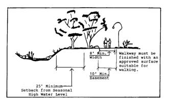
Setbacks from the stream shall be determined by the City’s Surface and Subsurface Drainage and Erosion Control Ordinance or by requirements set by the Washington State Department of Fisheries and/or Department of Wildlife, whichever is greater. (Ord. 2104, 1996; Ord. 2074 § 4.16(M), 1995).
19.80.140 Open space.
Open space should be arranged in such a way to utilize and enhance the natural amenities of the site.
Common open space should be available for use by residents, tenants, and the general public.
Open space may be used for passive recreation; landscaping; visual, noise or land use buffers; drainage control; or other purposes the City may approve during the project review and approval.
Locate open space so that it buffers the proposed development from neighboring developments. (Ord. 2104, 1996; Ord. 2074 § 4.16(N), 1995).
19.80.150 Grading of slopes.
All requirements of Chapter 16.20 MTMC shall be met, including compliance with MTMC 16.20.080(D) (Clearing and Grading Permit). (Ord. 2729 § 16, 2018; Ord. 2104, 1996; Ord. 2074 § 4.16(O), 1995).
19.80.160 Access – Egress.
Access and egress from the project should be designed to minimize conflicts on adjoining public rights-of-way.
The Planning Commission and City Council may impose additional requirements for the circulation system in order to mitigate negative impacts on surrounding areas. (Ord. 2104, 1996; Ord. 2074 § 4.16(P), 1995).
19.80.170 Phasing.
Phasing of projects may be permitted upon submission and approval of a conceptual, construction, and phasing plan and schedule for development of the entire parcel. Such a plan may contain no more than five phases, with the first phase containing at least 15 percent of the total land area.
An approved stream treatment and/or rehabilitation plan shall be completed as part of any Phase I construction.
Environmental review, including preparation of an environmental impact statement if required, shall be undertaken for the entire proposal and shall not be limited to a single phase.
No major change in use, intensity, site layout, utilities, open space, or public access shall be allowed from the approved conceptual plan unless such change is demonstrated by the proponent to be justified in light of conditions not contemplated at the time of approval of the conceptual plan and to be consistent with the provisions of this chapter and the Mountlake Terrace Comprehensive Plan.
All necessary permits for each phase must be issued before an occupancy permit can be obtained.
The City may impose additional or modified conditions upon the conceptual approval, subsequent to the granted approval, in order to mitigate impacts on the environment, the extent or nature of which were not known prior to actual development of any phase of the project, or in order to utilize information as to how to more effectively mitigate such impacts which were gained subsequent to commencement of actual development of any phase. (Amended by City request, 1/11; Ord. 2104, 1996; Ord. 2074 § 4.16(Q), 1995).
19.80.180 Use of concomitant agreement.
In the event that an integrated plan for an entire Special Development District is submitted which meets the purpose and intent of this title, is compatible with the surrounding land uses and general community, and respects the sensitivity of the environment, upon recommendation by the Planning Commission, the City Council, at their discretion, may revise, amend, or waive any of the criteria specified under this title through the execution of a binding concomitant agreement.
Through the use of a concomitant agreement, the City Council may specify, but shall not be limited to: permitted uses, densities, building size and height, setbacks, floor area requirements, size limitations of secondary uses, open space and landscape requirements, recreational requirements, traffic improvements, project design, phasing schedules, and construction materials.
The concomitant agreement shall state that it is subject to the normal hearing process. (Ord. 2104, 1996; Ord. 2074 § 4.16(R), 1995).
19.80.190 Submittal requirements – Preliminary site plan.
Application for preliminary site plan review shall be made on forms supplied by the Planning Department together with the supporting materials identified on those forms, and shall meet the requirements of a complete application as
described in MTMC 19.110.030 and 19.110.050. The review fee as determined by other City ordinances must accompany the completed application. The completed application must be submitted at least 28 days prior to the date of Planning Commission review. It is the applicant’s responsibility to become familiar with the provisions of the City’s Zoning Ordinance and other ordinances related to property use and development. If subdivision or binding site plan is proposed, the complete application shall include both site plan and subdivision or binding site plan proposals. (See Subdivision Ordinance for Subdivision Application Requirements.) (Ord. 2116, 1996; Ord. 2104, 1996; Ord. 2074 § 4.16(S), 1995).
19.80.200 Planning Commission review – Preliminary site plan.
Upon submission of all the required information to the Planning Department, the secretary shall include the proposal at the next meeting of the Planning Commission which would allow staff review.
The Planning Commission shall review the proposed project for compliance with the criteria of this title and other related standards of the City. The Planning Commission may exercise discretion in relaxing or waiving the design and development criteria herein set forth and the legislative body shall reserve to itself that same discretion to relax and/or waive said criteria, provided the basic intent of this district is preserved by the proposed plan.
The Planning Commission shall recommend to the City Council approval, disapproval, modification, or special conditions of approval.
The Planning Commission may also recommend to the City Council modifications to building location, design, parking, landscaping, lighting, access, utilities, and phasing elements that will make the project more compatible with the intent and design criteria of this title.
If subdivision is proposed, it shall be reviewed concurrently with the site plan. (Ord. 2116, 1996; Ord. 2104, 1996; Ord. 2074 § 4.16(T), 1995).
19.80.210 City Council preliminary approval.
The City Council shall consider the proposal and the recommendations of the Planning Commission following a City Council open record public hearing. (Ord. 2116, 1996; Ord. 2104, 1996; Ord. 2074 § 4.16(U), 1995).
19.80.220 Effect of preliminary approval.
Preliminary approval indicates approval of the concept of a proposal subject to any conditions specified in that approval. (Ord. 2104, 1996; Ord. 2074 § 4.16(V), 1995).
19.80.230 Preliminary approval period.
Final site plan approval shall be requested in writing within one year of preliminary approval. If the project is to be developed in phases, final approval for each phase shall be requested within time periods established by the City Council during the preliminary review. In any event, final approval for the first phase shall be requested within one year of preliminary approval. Failure to file such a request with the Planning Commission within the stated period shall result in expiration of preliminary plan approval and require re-approval of the preliminary site plan and payment of one-half of the original preliminary application fee. (Ord. 2104, 1996; Ord. 2074 § 4.16(W), 1995).
19.80.240 Final submittal and review.
Final site plan submittal shall be subject to the same review requirements of the preliminary approval except no hearings shall be required. Application for final site plan review shall be made on forms supplied by the Planning Department together with the supporting materials identified on those forms. The review fee for final application shall be one-half the preliminary fee for each phase reviewed. (Ord. 2104, 1996; Ord. 2074 § 4.16(X), 1995).
19.80.250 Final approval.
If the Planning Commission determines that the final site plan application is consistent with the approval of, and all conditions imposed upon the preliminary plan, the Commission shall recommend approval of the final site plan to the City Council. The City Council, upon verification of the Planning Commission determination shall approve the final plan.
Prior to final approval by the City Council, adequate guarantee, as determined by the City Attorney, must be provided to insure permanent maintenance of “open space” not dedicated for public use. (Ord. 2104, 1996; Ord. 2074 § 4.16(Y), 1995).
19.80.260 Final approval period.
Final approval shall be effective for two years, except as approved under a phasing plan, from the date of City Council approval of the final site plan and shall allow the applicant to apply for development permits within that period of time, not withstanding other time limitations of utility, site development, and building design. In any case, if subdivision is also approved, the final approval period shall be regulated by one final approval period provided for in the Subdivision Ordinance. (Ord. 2104, 1996; Ord. 2116, 1996; Ord. 2074 § 4.16(Z), 1995).
19.80.270 Modifications to final plan.
Modifications of access building locations, exterior finish or design of structure, change of proposed signing, exterior lighting, landscaping, or open space shall be subject to review as a final site plan, except that a hearing shall be required if major access points are modified or addition of new buildings is proposed. (Ord. 2104, 1996; Ord. 2074 § 4.16(AA), 1995).
19.80.280 Special regulations.
Special regulations, as specified below, shall apply to certain uses and locations in the SDD/R district:
A. The locational and area standards of this chapter and of any other regulations in this title pertaining to development under this chapter do not have to be met on individual lots, parcels or tracts developed under the provisions of Chapter 17.05 MTMC, Binding Site Plans, or Chapter 17.09 MTMC, Fee Simple Unit Lot Subdivisions; provided, that they are met on the collective lots, parcels and/or tracts in a binding site plan or fee simple unit lot subdivision and that all standards otherwise applicable to the outer perimeter of individual lots (e.g., setbacks, landscaping and buffers) are met around the outer perimeter of the binding site plan or fee simple unit lot subdivision.
B. In the SDD/R district, Chapter 19.126 MTMC shall regulate electric vehicle infrastructure. (Ord. 2660 § 12, 2015; Ord. 2553 § 11, 2010).