


Chapter 18.20
SHORELINE MASTER PROGRAM REGULATIONS
18.20.000 Chapter Contents
(Ord. 7280 §2, 2021; Ord. 7028 §4 (Exh. B), 2016).
Sections:
18.20.100 Applicability.
18.20.110 Relationship to Other Plans and Regulations.
18.20.120 Interpretation and Definitions.
18.20.200 General Permit and Authorization Provisions.
18.20.210 Shoreline Substantial Development Permits.
18.20.215 Exceptions to Local Review.
18.20.220 Exemptions from Shoreline Substantial Development Permit.
18.20.230 Shoreline Conditional Use Permits.
18.20.240 Shoreline Variances.
18.20.250 Unclassified Uses.
18.20.260 Submittal Requirements.
18.20.270 Inspections.
18.20.280 Shoreline Permit Procedures.
18.20.285 Amendments.
18.20.290 Appeals of Administrative Decisions.
18.20.295 Fees.
18.20.300 Shoreline Jurisdiction.
18.20.310 Official Shoreline Map.
18.20.320 Shoreline Environment Designations.
18.20.330 Shoreline Environment Purposes.
18.20.400 General Regulations – Intent.
18.20.410 No-Net-Loss and Mitigation.
18.20.420 Critical Areas.
18.20.430 Archaeological, Historic, and Cultural Resources.
18.20.440 Parking.
18.20.450 Public Access.
18.20.460 Design of Public Access.
18.20.470 Scientific and Educational Activities.
18.20.480 Signage Regulations.
18.20.490 Vegetation Conservation Areas - Intent.
18.20.492 General Vegetation Conservation Regulations.
18.20.493 Permitted Uses and Activities within Vegetation Conservation Areas.
18.20.494 Alterations to Existing Development.
18.20.495 Vegetation Conservation Area Standards.
18.20.496 Vegetation Management Plan.
18.20.500 View Protection - Intent.
18.20.504 View Protection Regulations.
18.20.507 Visual Impact Assessment.
18.20.510 Water Quality.
18.20.600 Shoreline Use and Development – Intent.
18.20.610 General Use and Development Provisions.
18.20.620 Use and Development Standards Tables.
18.20.630 Agriculture.
18.20.640 Aquaculture.
18.20.650 Boating Facilities - General Regulations.
18.20.652 Boat Launch Ramps.
18.20.654 Marinas.
18.20.656 Boat Storage.
18.20.658 Covered Moorage.
18.20.660 Commercial Use and Development – General.
18.20.663 Water-Oriented Commercial Use and Development.
18.20.667 Non-Water-Oriented Commercial Use and Development.
18.20.670 Industrial Development.
18.20.680 Recreation.
18.20.690 Residential Use and Development.
18.20.700 Transportation and Trail Facilities.
18.20.710 Utilities.
18.20.800 Shoreline Modifications – General Provisions.
18.20.810 Permitted Shoreline Modifications.
18.20.820 Dredging.
18.20.830 Fill.
18.20.833 Shoreland Fill.
18.20.837 Fill Water-ward of Ordinary High Water Mark.
18.20.840 General Moorage (Piers, Docks, Floats, and Buoys) Provisions.
18.20.842 Moorage Buoys.
18.20.844 Residential Docks, Piers or Floats.
18.20.846 Marine Docks and Piers.
18.20.847 Fresh Water Docks and Piers.
18.20.848 Float Standards.
18.20.850 Shoreline Restoration and Enhancement – Intent.
18.20.855 Shoreline Restoration and Enhancement - General Provisions.
18.20.857 Instream Structures.
18.20.860 Shoreline Stabilization - Intent.
18.20.862 Shoreline Stabilization - New Development.
18.20.864 New or Expanded Shoreline Stabilization Measures.
18.20.866 Shoreline Stabilization - Replacement and Repair.
18.20.868 Design of Shoreline Stabilization Measures.
18.20.870 Shoreline Stabilization Reports.
18.20.872 Breakwaters, Jetties, Groins, and Weirs – General Provisions.
18.20.874 Breakwaters, Jetties, Groins, and Weirs - Environment Designations.
18.20.900 Existing Buildings and Uses within Shorelines.
18.20.910 Alteration of Nonconforming Structures in Shoreline Jurisdiction.
18.20.920 Existing Nonconforming Shoreline Uses.
18.20.930 Existing Nonconforming Shoreline Lots.
18.20.100 Applicability
A. All proposed uses and development occurring within Olympia’s shoreline jurisdiction shall comply with Olympia’s Shoreline Program and RCW 90.58, Shoreline Management Act (Act). The Shoreline Program applies to all uses and developments within shoreline jurisdiction whether or not a shoreline permit or statement of permit exemption is required.
B. Olympia’s Shoreline Program shall apply to all of the lands and waters in the City of Olympia that fall under the jurisdiction of the Act (see OMC 18.20.300 - Shoreline Jurisdiction).
C. The Shoreline Program shall apply to every person, individual, firm, partnership, association, organization, corporation, local or state governmental agency, public or municipal corporation, or other non-federal entity which develops, owns, leases, or administers lands, wetlands, or waters that fall under the jurisdiction of the Act.
D. Federal agency actions on shorelines of the state are required to be consistent with this Master Program and the Act, as provided by the Coastal Zone Management Act (Title 16 United States Code §1451 et seq.; and §173-27-060(1) WAC, Applicability of RCW 90.58, Shoreline Management Act, to federal lands and agencies).
E. The permit requirements established under the Shoreline Program apply to all non-federal activities; and to development and uses undertaken on lands not federally owned but under lease, easement, license, or other similar property right of the federal government.
(Ord. 7280 §2, 2021; Ord. 7028 §4 (Exh. B), 2016).
18.20.110 Relationship to Other Plans and Regulations
A. Uses, developments and activities regulated by Olympia’s Shoreline Program may also be subject to the provisions of the City of Olympia Comprehensive Plan, the Olympia Municipal Code (OMC), the Olympia Engineering Design and Development Standards, the Washington State Environmental Policy Act (SEPA, RCW 43.21C and WAC 197-11), and various other provisions of local, state, and federal law.
B. Project proponents are responsible for complying with all applicable laws prior to commencing any use, development, or activity.
C. In the event Olympia’s Shoreline Program conflicts with other applicable City policies or regulations, all regulations shall apply and unless otherwise stated, the provisions most protective of the resource shall prevail.
D. Any inconsistencies between a Shoreline Program and the Shoreline Management Act must be resolved in accordance with the Act.
(Ord. 7280 §2, 2021; Ord. 7028 §4 (Exh. B), 2016).
18.20.120 Interpretation and Definitions
A. As provided for in RCW 90.58.900, the Act is exempt from the rule of strict construction. The Act and all aspects of Olympia’s Shoreline Program shall therefore be liberally construed to give full effect to the purposes, goals, objectives, and policies for which the Act and Olympia’s Shoreline Program were enacted and adopted.
B. For purposes of this Chapter, the City hereby adopts by reference the definitions of the following terms as set forth in the Revised Code of Washington 90.58.030 and the Washington Administrative Code 173-27-030 and 173-26-020:
• Agricultural activities,
• Agricultural land,
• Aquaculture,
• Average grade level,
• Development,
• Ecological functions or shoreline functions,
• Extreme low tide,
• Feasible,
• Fill,
• Flood plain,
• Geotechnical report or geotechnical analysis,
• Guidelines,
• Marine,
• Nonwater-oriented uses,
• Ordinary High Water Mark (OHWM),
• Priority habitat,
• Priority species,
• Restore, restoration or ecological restoration,
• Shoreline modification,
• Shorelines,
• Shorelines of statewide significance,
• Shorelines of the state,
• Structure,
• Substantial development,
• Substantially degrade,
• Water-dependent use,
• Water-enjoyment use,
• Water-oriented use,
• Water-related use, and
• Wetlands.
C. For the purposes of this Chapter, the terms defined below shall have the meaning ascribed to them below. Terms not defined in this Chapter nor listed in subsection B above shall be interpreted as set forth in WACs 173-18-030, 173-20-030 and 173-22-030 or OMC 18.02. When the definitions in this Chapter conflict with the definitions set forth in OMC 18.02, the definitions herein shall govern for purposes of this Chapter.
Access, direct: Physical access that is convenient, of relatively short distance, and does not require extraordinary physical dexterity.
Access, physical: The right and facilities needed to enter upon shoreline areas, such as that access provided by a trail, float, dock, promenade, bridge, or boat ramp.
Accessory: Customarily incidental and subordinate.
Administrator: That person designated by the City of Olympia to administer the provisions of Olympia’s Shoreline Program. References to ‘the City’ in this Shoreline Program may be construed as referring to the Administrator.
Alteration: Any human-induced change in existing conditions on a shoreline, critical area and/or its buffer. Alterations include, but are not limited to excavation, grading, filling, channelization (straightening, deepening or lining of stream channels except dredging of sediment or debris alone), dredging, clearing vegetation, draining, constructing structures, compaction, or any other activity that changes the character of a site.
Appurtenance: A structure or development that is necessarily connected to the use and enjoyment of another structure. Common appurtenances include a garage, deck, driveway, utilities, fences, and grading which does not exceed two hundred and fifty cubic yards. For purposes of this chapter appurtenances are limited to upland areas.
Backshore: The zone of accretion or erosion lying landward of the Ordinary High Water Mark, wetted by tides during storm events.
Beach: The zone along the shoreline where there is continuous movement of sediment both laterally and vertically. This zone extends from the daily low tide mark to where the permanent line of vegetation begins.
Beach Nourishment: The process of replenishing a beach by artificial means, for example, by the deposition of sand and gravel; also called beach replenishment or beach feeding.
Berm: One or several linear deposits of sand and gravel generally paralleling the shore at or landward of the Ordinary High Water Mark.
Boat ramp: A slab, plank, rail, or graded slope used for launching boats by means of a trailer, hand, or mechanical device.
Boat house: A structure designed for storage of vessels located over water or in upland areas.
Boating facilities: Marinas located both landward and water-ward of the Ordinary High Water Mark (dry storage and wet-moorage types), boat ramps, covered and uncovered moorage, and marine travel lifts. Boating facilities do not include docks serving four or fewer single-family residences.
Breakwater: An offshore structure generally built parallel to the shore that may or may not be connected to the land. Breakwaters may be fixed (e.g., a rubble mound or rigid wall), open-pile, or floating. Their primary purpose is to protect harbors, moorages and navigation activity from wave and wind action by creating a still-water area along the shore. A secondary purpose is to protect shorelines from erosion caused by wave action.
Bulkhead: A wall usually constructed parallel to the shoreline or at the Ordinary High Water Mark for the primary purpose of containing and preventing the loss of soil or structure caused by erosion or wave action. Bulkheads are typically constructed of rock, poured-in-place concrete, steel or aluminum sheet piling, wood, or wood and structural steel combinations. Structural foundation walls are not bulkheads unless located at the Ordinary High Water Mark.
Camping Facilities: Short-term overnight accommodations (generally 1-15 nights per guest) in organized facilities with amenities designed for guests and their enjoyment of the waterfront. Such facilities require amenities such as restrooms and may include opportunities for cooking, connection to electricity, and potable water. Amenities should be appropriate for the proposed use, such as electricity for recreational vehicles.
Compensation Project: Projects that compensate for unavoidable impacts by replacing or providing substitute resources environments.
Conditional Use: A use, development, or substantial development which is classified as a shoreline conditional use or not otherwise classified in this chapter. Shoreline conditional uses are not synonymous with zoning conditional uses.
Covered Moorage: Boat moorage, with or without walls, that has a solid roof to protect the vessel and is attached to the dock itself or the substrate of the water body. Overwater boat houses are a type of covered moorage.
Critical Habitat: Habitat areas within which endangered, threatened, sensitive or monitored plant, fish, or wildlife species have a primary association (e.g., feeding, breeding, rearing of young, migrating). Such areas are identified herein with reference to lists, categories, and definitions promulgated by the Washington Department of Fish and Wildlife as identified in WAC 232-12-011 or WAC 232-12-014; in the Priority Habitat and Species (PHS) program by the Department of Fish and Wildlife; or by rules and regulations adopted by the U.S. Fish and Wildlife Service, National Marine Fisheries Service, or other agency with jurisdiction for such designations.
Critical Saltwater Habitat: All kelp beds, eelgrass beds, spawning and holding areas for forage fish, such as herring, smelt and sandlance; subsistence, commercial and recreational shellfish beds; mudflats, intertidal habitats with vascular plants, and areas with which priority species have a primary association.
Cumulative impacts or cumulative effects: The impact on the environment or other shoreline functions or uses which results from the incremental impact of the action when added to other past, present, and reasonably foreseeable future actions regardless of what agency or person undertakes such other actions. Cumulative impacts can result from individually minor but collectively significant actions taking place over a long period of time. See WAC 173-26-186(8)(d).
Dike or Levee: A natural or human-made embankment, including any associated revetments, to prevent flooding by a stream or other water body.
Dock: A structure built from the shore extending out over the water to provide moorage for commercial or private recreation vessels that does not include above water storage. A dock may be built either on a fixed platform or float on the water.
Dredging: The removal, displacement, or disposal of unconsolidated earth material such as sand, silt, gravel, or other submerged materials, from the bottom of water bodies, ditches, or wetlands; maintenance dredging and/or support activities are included in this definition.
Ecologically Intact Shorelines: Those shoreline areas that retain the majority of their natural shoreline functions and values, as evidenced by vegetation and shoreline configuration. Generally, but not necessarily, ecologically intact shorelines are free of structural shoreline modifications, structures, and intensive human uses.
Enhancement: Actions performed within an existing degraded shoreline, critical area and/or buffer to intentionally increase or augment one or more functions and values of the existing area. Enhancement actions include, but are not limited to, increasing plant diversity and cover, increasing wildlife habitat and structural complexity (snags, woody debris), installing environmentally compatible erosion controls, or removing invasive plant or animal species.
Erosion: A process whereby wind, rain, water, and other natural agents mobilize, and transport, and deposit soil particles.
Fair market value: The open market bid price for conducting the work, using the equipment and facilities, and purchase of the goods, services, and materials necessary to accomplish the development. This would normally equate to the cost of hiring a contractor to undertake the development from start to finish, including the cost of labor, materials, equipment and facility usage, transportation, and contractor overhead and profit. The fair market value of the development shall include the fair market value of any donated, contributed or found labor, equipment, or materials.
Float: A floating platform similar to a dock that is anchored or attached to pilings and which does not connect to the shore. A float may serve as a temporary moorage facility but is not intended to be used for boat storage. Floats are also used for swimming, diving, or water skiing.
Floating home: A building on a float used in whole or in part for human habitation as a single-family dwelling that is moored, anchored, or otherwise secured in waters, and is not a vessel, even though it may be capable of being towed.
Floating on water residence: Any floating structure other than a floating home that: (i) is designed or used primarily as a residence on the water and has detachable utilities; and (ii) whose owner or primary occupant has held an ownership interest in space in a marina, or has held a lease or sublease to use space in a marina, since a date prior to July 1, 2014.
Flood hazard reduction measure: Flood hazard reduction measures may consist of nonstructural measures, such as setbacks, land use controls, wetland restoration, dike removal, use relocation, biotechnical measures, and stormwater management programs, and of structural measures, such as dikes, levees, revetments, floodwalls, channel realignment, and elevation of structures consistent with the National Flood Insurance Program (NFIP).
Floodway: The “floodway” area that has been established in Federal Emergency Management Agency rate maps not including those lands that can reasonably be expected to be protected from flood waters by flood control devices maintained by or maintained under license from the federal government, the state, or a political subdivision of the state.
Functional Disconnect: An existing, legally established public road or other substantially developed surface which effectively eliminates the capacity for upland areas to provide shoreline ecological functions, as defined in WAC 173-26-201(2)(c). As used in this definition, “substantially developed surface” can include public infrastructure such as roads, and private improvements such as commercial structures. A “substantially developed surface” shall not include paved trails, sidewalks, private driveways, or accessory buildings that do not require a building permit.
Gabions: Structures composed of masses of rocks, rubble, soil, masonry, or similar material held tightly together usually by wire mesh, fabric, or geotextile so as to form layers, blocks or walls. Sometimes used on heavy erosion areas to retard wave action or as foundations for breakwaters or jetties.
Groin: Structure built seaward at an angle or perpendicular to the shore for the purpose of building or preserving an accretion beach by trapping littoral sand drift. Generally narrow and of varying lengths, a groin may be built in a series along the shore.
Harbor Area: The area of navigable waters determined as provided in Article XV, Section 1 of the State Constitution, which shall be forever reserved for landings, wharves, streets, and other conveniences of navigation and commerce.
Height (of Structure): The difference between the average grade level and the highest point of a structure (not including temporary construction equipment); provided, that television antennas, chimneys, and similar appurtenances shall not be used in calculating height except where such appurtenances obstruct the view of the shoreline from a substantial number of residences on areas adjoining such shorelines.
Instream structure: A structure placed by humans within a stream or river water-ward of the Ordinary High Water Mark that either causes or has the potential to cause water impoundment or the diversion, obstruction, or modification of water flow. In-stream structures may include those for hydroelectric generation, irrigation, water supply, flood control, transportation, utility service transmission, fish habitat enhancement, or other purpose.
Jetty: A structure generally perpendicular to the shore, extending through or past the intertidal zone. Jetties are built singly or in pairs at harbor entrances or river mouths to prevent accretion of littoral drift in an entrance channel. Jetties also protect channels and inlets from storm waves and cross-currents and to stabilize inlets through barrier beaches. Most jetties are of riprap mound construction.
Joint-use: Sharing of facilities such as docks, piers, floats, and similar structures by more than one property owner or by a homeowners’ association or similar group.
Limited Master Program Amendment: A master program amendment that addresses specific procedural and/or substantive topics and which is not intended to meet the complete requirements of a comprehensive master program update.
Littoral drift: The mud, sand or gravel material moved parallel to the shoreline in the nearshore zone by waves and currents.
Live-aboard vessel: A vessel primarily used as a residence, and if used as a means of transportation or recreation, said transportation or recreation is a secondary or subsidiary use. Any vessel used for overnight accommodation for more than fifteen (15) nights in a one-month period shall be considered a residence.
Marina: A facility with water-dependent components for storing, servicing, fueling, berthing, launching and/or securing boats but at minimum including piers, buoys, or floats to provide moorage for five (5) or more boats. Marinas may provide eating, sleeping, and retail facilities for owners, crews, and guests. Those aspects located landward of the Ordinary High Water Mark are referred to as “backshore.” Backshore marinas include wet-moorage that is dredged out of the land to artificially create a basin and dry moorage with upland storage that uses a hoist, marine travel lift or ramp for water access. Marina features located in the intertidal or offshore zone water-ward of the Ordinary High Water Mark, including any breakwaters of open type construction (floating breakwater and/or open pile work) and/or solid type construction (bulkhead and landfill), are referred to as “foreshore.”
May: The action is acceptable, provided it conforms to the provisions of the SMP.
Mean Higher High Water (MHHW): The average of the higher high water height of each tidal day observed over the National Tidal Datum Epoch.
Mean Lower Low Water (MLLW): The average of the lower low water height of each tidal day observed over the National Tidal Datum Epoch.
Mitigation: Measures prescribed and implemented to avoid, minimize, lessen, or compensate for adverse impacts. Explicit in this definition is the following order of preference:
1. Avoiding an impact altogether by not taking a certain action or parts of actions;
2. Minimizing impacts by limiting the degree or magnitude of an action and its implementation;
3. Rectifying impacts by repairing, rehabilitating, or restoring the affected environment;
4. Reducing or eliminating an impact over time by preservation and maintenance operation during the life of the action;
5. Compensating for an impact by replacing or providing substitute resources or environments; and
6. Monitoring the mitigation and taking remedial action when necessary.
Mitigation plan: A plan for alleviating or lessening the adverse impacts of an activity or development, including measures such as avoiding, minimizing, or compensating for impacts. Mitigation plans should include a description and evaluation of existing environmental conditions, functions, and values; be prepared by a qualified person; list proposed and any alternative mitigation measures including any continuing activities and long-term performance assurance; evaluate the likelihood of success of those measures; and include a proposed means of monitoring and evaluating the success of the mitigation.
Mixed use: The use of a parcel or structure with two or more different land uses, such as a combination of residential, office, manufacturing, retail, public, or entertainment in a single or physically integrated group of structures.
Moorage Buoy: A floating device anchored to the bottom of a water body to provide tie-up capabilities for vessels or watercraft.
Must: A mandate; the action is required.
Natural Topography or Existing Topography: The topography of a lot, parcel, or tract of real property immediately prior to any site preparation or grading, including excavation or filling.
No Net Loss: The maintenance of the aggregate total of shoreline ecological functions over time. The no net loss standard contained in WAC 173-26-186 requires that impacts of shoreline use and/or development, whether permitted or exempt from permit requirements, be identified and mitigated such that there are no resulting impacts on ecological functions or processes.
Nonconforming Development or Nonconforming Structure: An existing structure that was lawfully constructed at the time it was built but is no longer fully consistent with present regulations such as setbacks, buffers, vegetation conservation areas, or yards; area; bulk; or height standards due to subsequent changes to the master program.
Nonconforming Lot: A lot that met dimensional requirements of the applicable master program at the time of its establishment but now contains less than the required width, depth, or area due to subsequent changes to the master program.
Nonconforming Use: An existing shoreline use that was lawfully established prior to the effective date of the act or the applicable master program, but which does not conform to present use regulations due to subsequent changes to the master program.
Overwater: Location above the surface of the water or water-ward of the Ordinary High Water Mark, including placement of buildings on piling or floats.
Pier: A fixed platform structure supported by piles in a water body that abuts the shore to provide landing for water dependent recreation or moorage for vessels or watercraft and does not include above water storage.
Port: When capitalized, that government agency known as the Port of Olympia; when lower-case, a center for water-borne commerce and traffic.
Primary Structure: The structure on a lot or parcel occupied by the principal use.
Public Access: The ability of the general public to reach, touch, and enjoy the water’s edge, to travel on the waters of the state, and to view the water and shoreline from adjacent locations. See WAC 173-26-221(4).
Public Interest: The interest shared by the citizens of the state or community-at-large in the affairs of government, or some interest by which their rights or liabilities are affected such as an effect on public property or on health, safety, or general welfare resulting from a use or development. See WAC 173-27-030(14).
Recreation: Activities and associated facilities for public or private use for refreshment of body and mind through play, amusement or relaxation including hiking, swimming, canoeing, photography, fishing, boat ramps, playgrounds, and parks.
Restoration plan: A plan to reestablish or upgrade impaired ecological shoreline processes or functions. Such plan may be to restore a site or shoreline area to a specific condition, or to reestablish functional characteristics and processes which have been lost due to alterations, activities, or catastrophic events. Restoration plans should identify the degraded site or area or impaired ecological function(s); establish specific restoration goals and priorities; describe the timing, elements, benchmarks, and other details of proposed restoration activities; include mechanisms or strategies to ensure successful implementation; and provide for monitoring and evaluation of the success of the restoration. Note: the term “Restoration Plan” may also refer to the shoreline Restoration Plan (Appendix A) that is a part of Olympia’s Shoreline Master Program.
Revetment: A sloped wall constructed of riprap or other suitable material placed on stream banks or other shorelines to retard bank erosion and minimize lateral movement. The slope differentiates it from a bulkhead, which is a vertical structure.
Riprap: Dense, hard, angular rock free from cracks or other defects conducive to weathering often used for bulkheads, revetments, or similar slope/bank stabilization purposes.
Sea Level Rise: An increase in the elevation of marine waters associated with changes in the state of the climate and which can be identified by changes in the mean and/or variability of its properties and that persists for decades or longer.
Shall: A mandate; the action must be done.
Shorelands or Shoreland areas: Lands extending landward for two hundred feet in all directions as measured on a horizontal plane from the Ordinary High Water Mark, floodways, and contiguous floodplain areas landward two hundred feet from such floodways, and all wetlands and river deltas associated with the streams, lakes, and tidal waters designated by the Department of Ecology as subject to the Shoreline Management Act.
Shoreline Master Program or Shoreline Program of Olympia: Specified goals and policies of the Olympia Comprehensive Plan together with specified use regulations and including maps, diagrams, charts, or other descriptive material and text, a statement of desired goals, and standards adopted in accordance with the policies of the Shoreline Management Act.
Shoreline Setback: The horizontal distance required between an upland structure or improvement and the Ordinary High Water Mark; usually measured in feet. (Note that in general setbacks are only applicable to structures having a height greater than 30 inches.) Shoreline setbacks outlined in Table 6.3 include and are not in addition to the VCAs outlined in Table 6.3
Shoreline Stabilization or Protection: Protection of shoreline upland areas and shoreline uses from the effects of shoreline wave action, flooding, or erosion through the use of structural and non-structural methods. See OMC 18.20.860 for examples.
Should: The particular action is required unless there is a demonstrated, compelling reason, based on policy of the Shoreline Management Act and this chapter, against taking the action.
Stair Tower: A structure twelve (12) feet or taller in height typically consisting of one (1) or more flights of stairs, usually with landings to pass from one level to another.
Submerged Lands: Areas below the Ordinary High Water Mark of marine waters, lakes and rivers.
Tideland: The land on the shore of marine water bodies between Ordinary High Water Mark (OHWM) or mean higher high tide (MHHW) and the line of extreme low tide which is submerged daily by tides.
Transportation Facilities: Streets, railways, bicycle lanes, sidewalks, and shared use paths consistent with the City of Olympia Engineering Design and Development Standards.
Variance, Shoreline: A means to grant relief from specific bulk, dimensional or performance standards set forth in this chapter or related state regulations pursuant to the criteria of WAC 173-27-170; such may not vary a use of a shoreline.
Vegetation Conservation: Activities to protect and restore vegetation along or near shorelines that minimize habitat loss and the impact of invasive plants, erosion, and flooding, and contribute to ecological functions of shoreline areas. Vegetation conservation provisions include the prevention or restriction of plant clearing and earth grading, vegetation restoration, and the control of invasive weeds and non-native species.
Vegetation Conservation Area: That area within which vegetation conservation actions take place, as required by this Chapter. Vegetation management provisions may be independent of a permit or approval requirement. VCAs outlined in Table 6.3 are measured from the Ordinary High Water Mark and are located within the shoreline setbacks outlined in Table 6.3.
Visual Access: Access with improvements that provide a view of the shoreline or water but that do not allow physical access to the shoreline.
Weir: A device placed in a stream or river to raise or divert the water.
(Ord. 7280 §2, 2021; Ord. 7187 §3, 2019; Ord. 7028 §4 (Exh. B), 2016).
18.20.200 General Permit and Authorization Provisions
A. To be authorized, all uses, and development shall be carried out in a manner that is consistent with the Olympia Shoreline Master Program and the policies of the Shoreline Management Act as required by RCW 90.58.140(1), regardless of whether a shoreline permit, statement of exemption, shoreline variance, or shoreline conditional use permit is required.
B. No use, alteration, or development shall be undertaken within the regulated shorelines by any person without first obtaining permits or authorization.
C. Applicants shall apply for shoreline substantial development, variance, and conditional use permits on forms provided by the City. Applications shall contain information required in WAC 173-27-180.
D. All permit applications shall be processed in accordance with the rules and procedures set forth in OMC Titles 14, 16, 17 and 18 and WAC 173-27. Where in conflict state law shall prevail.
E. The City shall document all project review actions in shoreline jurisdiction. The City shall review this documentation and evaluate the cumulative effects of authorized development on shoreline conditions as part of the 8-year periodic review cycle identified in RCW 90.58.080 (4).
(Ord. 7280 §2, 2021; Ord. 7028 §4 (Exh. B), 2016).
18.20.210 Shoreline Substantial Development Permits
A. A Shoreline Substantial Development Permit shall be required for all proposed use and development of shorelines unless the proposal is specifically exempted in accordance with WAC 173-27-040 and RCW 90.58.
B. In order to be approved, the decision maker shall find that the proposal is consistent with the following criteria:
1. The policies and procedures of RCW 90.58 and provisions of WAC 173-27-150; and
2. All policies and regulations of this Shoreline Program appropriate to the shoreline environment designation and the type of use or development proposed shall be met, except any bulk or dimensional standards that have been modified by approval of a shoreline variance.
C. Conditions may be attached to the approval of permits as necessary to assure consistency of the project with the Act and this Shoreline Program.
D. The City is the final authority for a Shoreline Substantial Development Permit unless an appeal is filed with the State Shorelines Hearings Board.
(Ord. 7280 §2, 2021; Ord. 7028 §4 (Exh. B), 2016).
18.20.215 Exceptions to Local Review
A. Requirements to obtain a Substantial Development Permit, Conditional Use Permit, Variance, exemption, or other review to implement the Shoreline Management Act do not apply to the following:
1. Remedial actions. Pursuant to RCW 90.58.355, any person conducting a remedial action at a facility pursuant to a consent decree, order, or agreed order issued pursuant to chapter 70.105D RCW, or to the department of ecology when it conducts a remedial action under chapter 70.105D RCW.
2. Boatyard improvements to meet NPDES permit requirements. Pursuant to RCW 90.58.355, any person installing site improvements for storm water treatment in an existing boatyard facility to meet requirements of a national pollutant discharge elimination system storm water general permit.
3. WSDOT facility maintenance and safety improvements. Pursuant to RCW 90.58.356, Washington State Department of Transportation projects and activities meeting the conditions of RCW 90.58.356 are not required to obtain a Substantial Development Permit, Conditional Use Permit, Variance, letter of exemption, or other local review.
4. Projects consistent with an environmental excellence program agreement pursuant to RCW 90.58.045.
5. Projects authorized through the Energy Facility Site Evaluation Council process, pursuant to chapter 80.50 RCW.
(Ord. 7280 §2, 2021).
18.20.220 Exemptions from Shoreline Substantial Development Permit
A. Certain developments are exempt from the requirement to obtain a Substantial Development Permit. Such developments still may require a Shoreline Variance or Conditional Use Permit, and all development within the shoreline is subject to the requirements of this Shoreline Program, regardless of whether a Substantial Development Permit is required. Developments which are exempt from the requirement for a Substantial Development Permit are identified in WAC 173-27-040, RCW 90.58.030(3)(e), RCW 90.58.147 and RCW 90.58.515.
B. Whenever a development is exempt from the requirement to obtain a Shoreline Substantial Development Permit and the development is subject to one or more of the following federal permits, a letter of exemption is required pursuant to WAC 173-27-050:
1. A U.S. Army Corps of Engineers Section 10 Permit under the Rivers and Harbors Act of 1899; or
2. A Section 404 Permit under the Federal Water Pollution Control Act of 1972.
(Ord. 7280 §2, 2021; Ord. 7028 §4 (Exh. B), 2016).
18.20.230 Shoreline Conditional Use Permits
A. The purpose of a Shoreline Conditional Use Permit is to provide a system which allows flexibility in the application of use regulations in a manner consistent with the policies of RCW 90.58.020. In authorizing a Shoreline Conditional Use Permit, special conditions may be attached by the City or the Department of Ecology to control any undesirable effects of the proposed use and to assure consistency with the Shoreline Management Act and Olympia’s Shoreline Program.
B. Uses which are classified in this Chapter as conditional uses may be authorized provided that the applicant can satisfy the criteria set forth in WAC 173-27-160:
1. That the proposed use will be consistent with the policies of RCW 90.58.020 and the Shoreline Program;
2. That the proposed use will not interfere with the normal public use of public shorelines;
3. That the proposed use of the site and design of the project is compatible with other authorized uses within the area and with uses planned for the area under the Comprehensive Plan and Shoreline Program;
4. That the proposed use will cause no significant adverse effects to the shoreline environment in which it is to be located; and
5. That the public interest suffers no substantial detrimental effect.
C. In the granting of all Shoreline Conditional Use permits, consideration shall be given to the cumulative impact of additional requests for like actions in the area. For example, if Shoreline Conditional Use Permits were granted for other developments in the area where similar circumstances exist, the total of the conditional uses shall also remain consistent with the policies of RCW 90.58.020 and shall not produce substantial adverse effects to the shoreline environment.
D. Other uses which are not specifically classified as a permitted or conditional use in this Shoreline Program may be authorized as a shoreline conditional use provided that the applicant can satisfy the criteria set forth in WAC 173-27-160 (see B above).
E. Uses that are specifically prohibited by this Chapter shall not be authorized.
(Ord. 7280 §2, 2021; Ord. 7028 §4 (Exh. B), 2016).
18.20.240 Shoreline Variances
A. The purpose of a shoreline variance is strictly limited to granting relief from specific bulk, dimensional, or performance standards set forth in this chapter where there are extraordinary circumstances relating to the physical character or configuration of property such that the strict implementation of Olympia’s Shoreline Program will impose unnecessary hardships on the applicant or thwart the policies set forth in RCW 90.58.020.
B. Shoreline Variance Permits should be granted in circumstances where denial of the permit would result in a thwarting of the policy enumerated in RCW 90.58.020. In all instances the applicant must demonstrate that extraordinary circumstances exist, and the public interest will suffer no substantial detrimental effect.
C. Variances from the use regulations of this Shoreline Program are prohibited.
D. Land shall not be subdivided to create parcels that are buildable only with a shoreline variance or would be considered non-conforming.
E. Variances for development and/or uses that will be located landward of the Ordinary High Water Mark and/or landward of any associated wetland may be authorized provided the applicant can demonstrate all of the following:
1. That the strict application of the bulk, dimensional or performance standards set forth in this chapter precludes, or significantly interferes with, reasonable use of the property;
2. That the hardship described above is specifically related to the property, and is the result of unique conditions such as irregular lot shape, size, or natural features and the application of the Olympia Shoreline Program, and not, for example, from deed restrictions or the applicant’s own actions;
3. That the design of the project is compatible with other authorized uses within the area and with uses planned for the area under the Comprehensive Plan and Shoreline Program and will not cause adverse impacts to the shoreline environment;
4. That the variance will not constitute a grant of special privilege not enjoyed by other properties in the area;
5. That the variance request is the minimum necessary to afford relief; and
6. That the public interest will suffer no substantial detrimental effect.
F. Variance permits for development and/or uses that will be located water-ward of the Ordinary High Water Mark, or within any wetland may be authorized provided the applicant can demonstrate all of the following:
1. That the strict application of the bulk, dimensional or performance standards set forth in this Shoreline Program precludes all reasonable use of the property not otherwise prohibited by this Shoreline Program;
2. That the proposal is consistent with the criteria established under Section E above; and
3. That the public rights of navigation and use of the shoreline will not be adversely affected.
G. In the granting of any shoreline variance, consideration shall be given to the cumulative impact of additional requests for like actions in the area. In other words, if Shoreline Variance Permits were granted for other developments in the area where similar circumstances exist, the total of the variances shall also remain consistent with the policies of RCW 90.58.020 and shall not produce substantial adverse effects to the shoreline environment.
(Ord. 7280 §2, 2021; Ord. 7028 §4 (Exh. B), 2016).
18.20.250 Unclassified Uses
A. Other uses not specifically classified or set forth in this chapter may be authorized as shoreline conditional uses provided the applicant can satisfy the Shoreline Conditional Use Permit criteria set forth above.
B. Uses that are specifically prohibited by this chapter cannot be authorized by a Shoreline Conditional Use permit.
(Ord. 7280 §2, 2021; Ord. 7028 §4 (Exh. B), 2016).
18.20.260 Submittal Requirements
All development proposals under the jurisdiction of this chapter shall satisfy the application submittal requirements set forth in OMC Titles 16, 17 and 18.
(Ord. 7280 §2, 2021; Ord. 7028 §4 (Exh. B), 2016).
18.20.270 Inspections
Pursuant to RCW 90.58.200, the Administrator or authorized representatives may enter land or structures to enforce the provisions of the Shoreline Program. Such entry shall follow the provisions set forth in OMC 8.24.080.
(Ord. 7280 §2, 2021; Ord. 7028 §4 (Exh. B), 2016).
18.20.280 Shoreline Permit Procedures
A. Applications for Shoreline Substantial Development Permits, Conditional Use Permits, and Variance Permits are subject to and shall be processed pursuant to WAC Chapter 173-27, as now or hereafter amended, and as provided below.
B. Applications for Shoreline Substantial Development, Conditional Use, and Variance Permits shall be submitted to the Planning Department on forms supplied by the Department. The application shall contain the information required by WAC 173-27-180 and such other information as may be required by the Department. The applicant shall pay to the Department the application fee prescribed by the approved fee schedule. In addition to the application fee, the applicant shall pay fees for environmental analysis, and for other necessary actions or approvals.
C. Applications for Shoreline Substantial Development Permits or shoreline exemptions are decided by the Administrator, unless elevated by the Administrator to a Hearing Examiner decision because the proposal is extraordinarily complex, has significant impacts beyond the immediate site, is of a community wide interest, or is of a controversial nature. The Hearing Examiner shall hold a public hearing and render a decision for all Conditional Use Permit and Variance Permit applications. Consistent with RCW 90.58.140 (10), the Department of Ecology must approve or disapprove Shoreline Conditional Use Permits and shoreline variances issued by the City.
D. Pursuant to WAC 173-27-110, notice of the application and hearing shall be published in the manner prescribed therein, and mailed to the latest recorded real property owners as shown by the records of the county assessor within at least three hundred feet of the boundary of the subject property, fifteen (15) days before the hearing. In addition, the Planning Department, in its discretion, may give notice in any other additional manner deemed appropriate.
E. The decision of the Administrator may be appealed to the hearings examiner per OMC 18.20.290. The Hearing Examiner decision may be appealed to the Shorelines Hearing Board pursuant to WAC 173-27-220.
F. Pursuant to WAC 173-27-090 and 173-27-100, the Administrator shall review and decide requests for time extensions and permit revisions. Any permit revision approval must be submitted to the Department of Ecology. The decision of the Administrator may be appealed pursuant to OMC 18.20.290. If the revision to the original permit involves a Conditional Use Permit or Variance, the City shall submit the revision to the Department of Ecology for its final decision. Conditional Use Permit or Variance decisions may be appealed to the Shoreline Hearings Board pursuant to WAC 173-27-220.
G. When developing an administrative interpretation of this Master Program, the City shall consult with the Department of Ecology to ensure that any formal written interpretations are consistent with the purpose and intent of the Act and the SMP Guidelines.
(Ord. 7280 §2, 2021; Ord. 7028 §4 (Exh. B), 2016).
18.20.285 Amendments
A. Amendments to the Shoreline Master Program, including changes in mapped environmental designations, shall be processed pursuant to Chapter 173-26-100 WAC as now or hereafter amended, and as provided below. All such amendments are required to be approved by the Department of Ecology.
B. Applications for proposed amendments shall be submitted to the Planning Department on forms supplied by the Department. The applicant shall pay to the Department the application fee and fees for environmental analysis pursuant to RCW 43.21C (SEPA), and for other necessary actions or approvals.
C. The City Council shall hold the public hearing prescribed by WAC 173-26-100(1). At any time, the Council may refer a proposed amendment to the Planning Commission for a recommendation. If the Planning Commission elects to hold a public hearing, a notice of the hearing shall be given in the same manner as the hearing held by the Council.
D. The City may utilize the optional joint review process for SMP amendments according to the procedures prescribed in WAC 173-26-104.
E. If the proposed amendment is a map change of environmental designation, regardless of the size or number of parcels affected, or regardless of whether the applicant is a private person or governmental agency, notice of the proposed amendment shall be mailed to all the owners of the property which is proposed for redesignation, as shown by the records of the county assessor. In addition, notice shall be mailed to all the owners of property which lies within three hundred feet of the boundary of the property proposed for designation. The applicant shall furnish to the Planning Department the names and addresses of property owners who are to receive notice.
(Ord. 7280 §2, 2021; Ord. 7028 §4 (Exh. B), 2016).
18.20.290 Appeals of Administrative Decisions
A. Any aggrieved person may appeal an administrative decision made pursuant to the Master Program by filing a written appeal with the Planning Department within fourteen (14) calendar days from the date of decision. The appeal shall be filed on forms prescribed by the Department and the appellant shall pay to the Department the appeal fee prescribed by the approved fee schedule.
B. Appeals of administrative decisions shall be decided by the hearings examiner, after appeal hearing, and shall be subject to the provisions of OMC 18.70.170. Notice of the hearing shall be mailed to the appellant and may be mailed to any other person who the Planning Department believes may be affected by or interested in the appeal. Notice shall be mailed not later than ten (10) days before the hearing.
(Ord. 7280 §2, 2021; Ord. 7028 §4 (Exh. B), 2016).
18.20.295 Fees
For purposes of this chapter, the fee schedule in Section 4.40.010 of the Olympia Municipal Code is considered the “approved fee schedule.”
(Ord. 7280 §2, 2021; Ord. 7028 §4 (Exh. B), 2016).
18.20.300 Shoreline Jurisdiction
A. The provisions of this Chapter shall apply to all shorelines of the state, all shorelines of statewide significance and shorelands as defined in RCW 90.58.030, within the City of Olympia. These areas are collectively referred to herein as ‘shorelines’.
B. Olympia’s “shorelands” include lands extending landward for two hundred feet in all directions as measured on a horizontal plane from the Ordinary High Water Mark, floodways, and contiguous floodplain areas landward 200 feet from such floodways, and all wetlands and river deltas associated with the following bodies of water. The City has chosen not to regulate ‘optional’ shorelands as described in RCW 90.58.030 through this Shoreline Program. Within its municipal boundaries, the City of Olympia shall have authority over the shorelines (water areas) and associated shorelands of Budd Inlet, Capitol Lake, Chambers Lake, Grass Lake, Ken Lake, Ward Lake, Black Lake Ditch and Percival Creek, including those waters of Budd Inlet seaward of extreme low tide which are shorelines of statewide significance.
C. In circumstances where the shoreline jurisdiction does not include an entire parcel, only that portion of the parcel within shoreline jurisdiction and any use, activity, or development proposed on that portion of the parcel is subject to the City’s Shoreline Master Program regulations. When a structure is partially in and partially out of the shoreline jurisdiction, the entire structure must comply with the Shoreline Master Program. When development on a parcel is completely outside of the shoreline jurisdiction it does not need to comply with the SMP.
(Ord. 7280 §2, 2021; Ord. 7028 §4 (Exh. B), 2016).
18.20.310 Official Shoreline Map
A. Shoreline Environment Designations have been established and are delineated on the “City of Olympia Shoreline Map” (Shoreline Map) hereby incorporated by reference. The official copy of this map shall reside with the Washington State Department of Ecology.
B. The Shoreline Map (Figure 4.1) identifies shoreline environment designations and the approximate extent of shoreline jurisdiction within City boundaries. It does not identify or depict the lateral extent of shoreline jurisdiction or associated wetlands and floodplains. The lateral extent of the shoreline jurisdiction shall be determined on a case-by-case basis by the project applicant or a qualified professional, as necessary. The actual extent of shoreline jurisdiction requires a site-specific evaluation to identify the location of the Ordinary High Water Mark (OHWM) and associated wetlands and/or floodplains.
C. Where uncertainty or conflict occurs in the exact location of a shoreline designation boundary, the Administrator shall interpret the boundaries based upon:
1. The coordinates listed in Shoreline Environmental Designations for the City of Olympia;
2. Boundaries indicated as approximately following lot, tract, or section lines;
3. Boundaries indicated as approximately following roads or railways shall be construed to follow their centerlines; and
4. Boundaries indicated as approximately parallel to or extensions of features indicated in 2 or 3 above shall be so construed.
D. In the event of a mapping error, the City will rely on the criteria in the statute and the WAC pertaining to the determination of shorelines.
(Ord. 7280 §2, 2021; Ord. 7028 §4 (Exh. B), 2016).
18.20.320 Shoreline Environment Designations
A. The Olympia Comprehensive Plan sets forth the designation and management policies for the shoreline environment designations established in the Olympia Shoreline Program.
B. Areas within shoreline jurisdiction that are not mapped and/or designated are automatically assigned an Urban Conservancy environment designation until the shoreline can be designated through a Shoreline Program amendment.
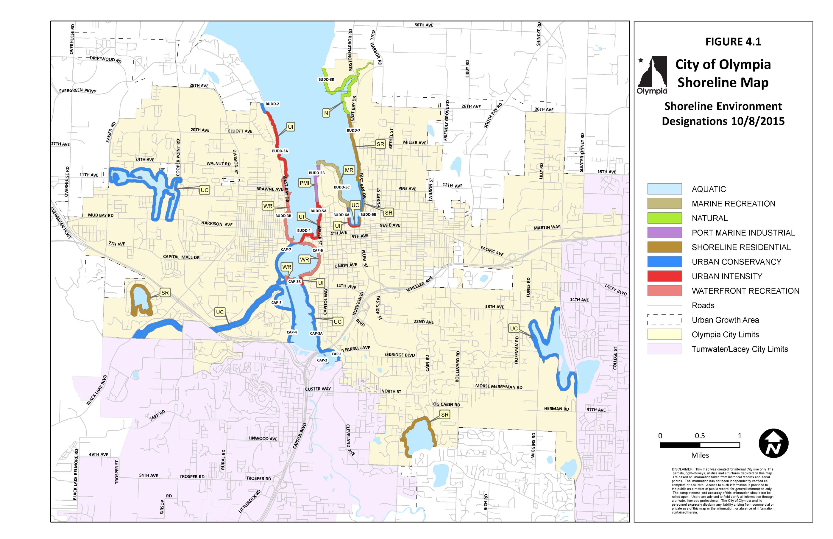
Map Figure 4.1
(Ord. 7280 §2, 2021; Ord. 7090 §11 (Exh. A), 2017; Ord. 7028 §4 (Exh. B), 2016).
18.20.330 Shoreline Environment Purposes
Aquatic – The purpose of the Aquatic environment is to protect, restore and manage the unique characteristics and resources of the areas water-ward of the Ordinary High Water Mark.
Natural – The purpose of the Natural environment is to protect those shoreline areas that are relatively free of human influence or that include intact or minimally degraded shoreline functions intolerant of human use. These systems require that only very low intensity uses be allowed in order to maintain the ecological functions and ecosystem-wide processes. Consistent with the policies of the designation, Olympia will plan for restoration of degraded shorelines within this environment.
Urban Conservancy – The purpose of the Urban Conservancy environment is to protect and restore ecological functions of open space, flood plain and other sensitive lands where they exist in urban and developed settings, while allowing a variety of compatible uses.
Waterfront Recreation – The purpose of the Waterfront Recreation environment is to provide recreational and public access opportunities and to maintain and restore shoreline ecological functions and preserve open space. This designation is generally intended for appropriate public parks.
Marine Recreation – The purpose of the Marine Recreation environment is to establish provisions for boating facilities and water-oriented recreational and commercial uses and to restore shoreline ecological functions and preserve open space.
Shoreline Residential – The purpose of the Shoreline Residential environment is to accommodate residential development and appurtenant structures that are consistent with Olympia’s Shoreline Program. An additional purpose is to provide public access and recreational uses.
Urban Intensity – The purpose of the Urban Intensity environment is to provide for high-intensity water-oriented commercial, transportation, industrial, recreation, and residential uses while protecting existing ecological functions and restoring ecological functions in areas that have been previously degraded, and to provide public access and recreational uses oriented toward the waterfront.
Port Marine Industrial – The purpose of the Port Marine Industrial environment is to allow the continued use and development of high-intensity water-oriented transportation, commercial and industrial uses. This area should support water-oriented marine commerce balanced with the protection of existing ecological functions and restoration of degraded areas.
(Ord. 7280 §2, 2021; Ord. 7028 §4 (Exh. B), 2016).
18.20.400 General Regulations – Intent
OMC Sections 18.20.400 through 18.20.510 set forth regulations that apply to all uses and activities, as applicable, in all shoreline environments. These regulations are to be used in conjunction with the OMC 18.20.600, et seq.
(Ord. 7280 §2, 2021; Ord. 7028 §4 (Exh. B), 2016).
18.20.410 No-Net-Loss and Mitigation
A. All shoreline uses and development, including preferred uses and uses that are exempt from shoreline permit requirements, shall be located, designed, constructed, and maintained in a manner that maintains shoreline ecological functions and processes.
B. Applicants/proponents of new shoreline use, and development shall demonstrate that all reasonable efforts have been taken to avoid adverse environmental impacts. Mitigation shall occur in the following order of priority:
1. Avoiding the adverse impact altogether by not taking a certain action or parts of an action, or moving the action;
2. Minimizing adverse impacts by limiting the degree or magnitude of the action and its implementation by using appropriate technology and engineering, or taking affirmative steps to avoid or reduce adverse impacts;
3. Rectifying the adverse impact by repairing, rehabilitating, or restoring the affected environment;
4. Reducing or eliminating the adverse impact over time by preservation and maintenance operating during the life of the action;
5. Compensating for the adverse impacts by replacing, enhancing, or providing similar substitute resources or environments; and
6. Monitoring the impact of the compensation projects and taking appropriate corrective measures.
C. In determining appropriate mitigation measures, lower priority measures shall be applied only when higher priority measures are determined to be infeasible or inapplicable.
D. Mitigation actions shall not have a significant adverse impact on other shoreline ecological functions.
E. The City may require applicants to prepare special reports as necessary to address the impacts of proposed development on shoreline ecological functions or to demonstrate that avoidance is not feasible.
F. When mitigation measures are required, all of the following shall apply:
1. The quality and quantity of the replaced, enhanced, or substituted resources shall be the same or better than the affected resources;
2. The mitigation site and associated vegetative planting shall be nurtured and maintained such that healthy native plant communities can grow and mature over time;
3. The mitigation shall be informed by pertinent scientific and technical studies, including but not limited to the Shoreline Inventory (TRPC, June 2009), Shoreline Analysis and Characterization Report (ESA Adolfson, December 2008), Olympia’s Shoreline Restoration Plan (Appendix A to the Master Program) and that of other jurisdictions, and other background studies prepared in support of this Program;
4. The mitigation plan shall include contingencies should the mitigation fail during the monitoring/maintenance period;
5. Compensatory mitigation shall be done prior to or at the same time as the impact; and
6. The mitigation activity shall be monitored and maintained to ensure that it achieves its intended functions and values. Mitigation sites shall be monitored for ten (10) years in accordance with the provisions in OMC 18.32.
G. The applicant may be required to post a financial surety such as an assignment of savings or bond that is 125 percent of the estimated cost of the mitigation to guarantee performance. Estimates shall be prepared in accordance with OMC 18.32. Sureties shall only be released upon acceptance of the mitigation project by the City. If the mitigation project has not performed as prescribed in the mitigation plan, the City shall have the authority to extend the monitoring and surety period, and require additional monitoring reports and maintenance activities beyond the 10-year monitoring period. This requirement applies to all projects where mitigation is used.
H. Mitigation measures shall occur in the immediate vicinity of the impact. If this is not feasible as determined through the mitigation sequence process (OMC 18.20.410(B)), mitigation may occur offsite if it provides greater improvement to shoreline ecological functions and values. The City may also approve use of alternative mitigation practices such as in-lieu fee programs, mitigation banks, and other similar approaches provided they have been approved by the Department of Ecology, the Department of Fish and Wildlife, or the Army Corps of Engineers.
I. Type and Location of Mitigation:
1. The Administrator shall give preference to mitigation projects that are located within the City of Olympia. Prior to mitigating for impacts outside City of Olympia jurisdiction, applicants must demonstrate to the Administrator that the preferences herein cannot be met within City boundaries.
2. Natural, Shoreline Residential, Urban Conservancy, Waterfront Recreation, and Aquatic Environments: Compensatory mitigation for ecological functions shall first be in-kind and onsite, or second in-kind and within the same reach, sub-basin, or drift cell, except when all of the following apply:
a. It is demonstrated to the satisfaction of the Administrator that there are no reasonable onsite or in sub-basin opportunities (e.g., onsite options would require elimination of high functioning upland habitat), or onsite and in sub-basin opportunities do not have a high likelihood of success based on a determination of the natural capacity of the site to compensate for impacts. Considerations should include anticipated marine shoreline/wetland/stream mitigation ratios, buffer conditions and proposed widths, available water to maintain anticipated hydrogeomorphic classes of wetlands or streams when restored, proposed flood storage capacity, potential to mitigate riparian fish and wildlife impacts (such as connectivity); and
b. Offsite mitigation has a greater likelihood of providing equal or improved shoreline ecological functions than the impacted shoreline.
3. Urban Intensity, Marine Recreation and Port Marine Industrial Environments:
a. The preference for compensatory mitigation is for innovative approaches that would enable the concentration of mitigation into larger habitat sites in areas that will provide greater critical area or shoreline function.
b. The Administrator may approve innovative mitigation projects including but not limited to activities such as advance mitigation, fee in-lieu, mitigation banking and preferred environmental alternatives subject to the mitigation sequencing process contained in Section 18.20.410. Innovative mitigation proposals must offer an equivalent or better level of protection of shoreline ecological functions and values than would be provided by a strict application of onsite and in-kind mitigation. The Administrator shall consider the following for approval of an innovative mitigation proposal:
1) Creation or enhancement of a larger system of natural areas and open space is preferable to the preservation of many individual habitat areas;
2) Consistency with Goals and Objectives of the Shoreline Restoration Plan and the Goals and Objectives of this Program;
3) The applicant demonstrates that long-term management and protection of the habitat area will be provided;
4) There is clear potential for success of the proposed mitigation at the proposed mitigation site;
5) Restoration of marine shoreline functions or critical areas of a different type is justified based on regional needs or functions and processes;
6) Voluntary restoration projects.
J. Fee in Lieu:
1. To aid in the implementation of offsite mitigation, the City may develop a formal program which prioritizes shoreline areas included in the Restoration Plan for use as mitigation and/or allows payment in lieu of providing mitigation on a development site. This program shall be developed and approved through a public process and be consistent with state and federal rules. The program should address:
a. The identification of sites within the City that are suitable for use as offsite mitigation and are consistent with the Shoreline Restoration Plan. Site suitability shall take into account shoreline ecological functions, potential for degradation, and potential for urban growth and service expansion; and
b. The use of fees for mitigation on available sites that have been identified as suitable and prioritized for restoration and/or enhancement;
c. Any offsite mitigation would have to be consistent with the goals and objectives of the Shoreline Restoration Plan.
2. If a fee-in-lieu program is approved by the City then in cases where mitigation pursuant to this section is not possible, or where the maximum possible onsite mitigation will not wholly mitigate for anticipated impacts, or where an alternative location, identified in an adopted restoration plan, would provide greater ecological function, the Administrator may approve a payment of a fee in lieu of mitigation. The fee shall be reserved for use in high value restoration actions identified through the Shoreline Restoration Plan.
K. Advance Mitigation
1. Advance mitigation is a form of permittee responsible compensatory mitigation constructed in advance of a permitted impact.
2. To aid in the implementation of advance mitigation, the City may develop a formal advance mitigation program. This program shall be developed and approved through a public process and be consistent with state and federal rules as defined in the Interagency Regulatory Guide: Advance Permittee-Responsible Mitigation (December 2012). At a minimum, the program should address:
a. Credit value of advance mitigation proposals
b. Credits can only be used by the same applicant
c. Establish performance standards
d. Establish baseline conditions
3. Any advance mitigation project shall be consistent with the goals and objectives of the Shoreline Restoration Plan.
L. Effect on Building Setbacks
1. No building shall be rendered nonconforming with respect to building setbacks as a result of shoreline restoration or mitigation conducted in accordance with this SMP.
(Ord. 7280 §2, 2021; Ord. 7028 §4 (Exh. B), 2016).
18.20.420 Critical Areas
A. All uses and development occurring within the shoreline jurisdiction shall comply with the critical areas regulations adopted by the City Council as of May 18, 2021 (Ordinance No. 7280) and codified in Chapter 18.32 (critical area regulations) and Chapter 16.70 (flood damage prevention), except as modified in (C) below.
B. If there are any conflicts or unclear distinctions between this chapter and Olympia’s critical area or flood damage prevention regulations, the requirements that are the most consistent with the Shoreline Management Act or Washington Administrative Code pertaining to shoreline management shall apply.
C. Regardless of other provisions in Chapter 18.32, to ensure consistency with the Shoreline Management Act critical areas within shoreline jurisdiction shall be subject to the following:
1. In shoreline jurisdiction, critical area review and permit procedures will be incorporated into and conducted consistently with the associated shoreline permit or exemption review and approval.
2. Stream and Important Riparian Area buffer reductions beyond twenty-five percent (25%) within shoreline jurisdiction shall require a shoreline variance.
3. Stormwater facilities may be allowed in the outer twenty-five percent (25%) of Category III and IV wetland buffers in shoreline jurisdiction (OMC 18.32.525(I)) and only when no other location is feasible.
4. Utility lines may be allowed in the outer twenty-five percent (25%) of Category III and IV wetland buffers in shoreline jurisdiction (OMC 18.32.525(L)).
5. Locating stormwater facilities or utilities within wetlands or within any wetland buffer other than those specified in numbers 3 and 4 above shall require a shoreline variance (OMC 18.32.530(E) and (G)).
6. Wetland buffer reductions beyond twenty-five percent (25%) within shoreline jurisdiction shall require a shoreline variance.
7. Reasonable use exceptions (OMC 18.66.040) are not available for relief from critical area standards within the shoreline jurisdiction. Instead, applicants seeking relief from the critical area standards shall apply for a shoreline variance.
8. New development or the creation of new lots that would cause foreseeable risk from geological conditions during the life of the development is prohibited.
9. Uses and activities that may be authorized within floodways are limited to those listed in WAC 173-26-221 (3)(c)(i).
Priority riparian area buffers are set forth in OMC 18.32.435 Streams and Priority Riparian Areas– Buffers.
(Ord. 7280 §2, 2021; Ord. 7090 §3, 2017; Ord. 7028 §4 (Exh. B), 2016).
18.20.430 Archaeological, Historic, and Cultural Resources
A. Archaeological sites located both in and outside shoreline jurisdiction are subject to RCW 27.44 (Indian Graves and Records) and RCW 27.53 (Archaeological Sites and Records).
B. Development or uses that impact such sites shall comply with WAC 25-48 (Archaeological Excavation and Removal Permit) as well as the requirements of OMC 18.12, Historic Preservation, and the applicable requirements of this chapter.
C. Shoreline use and development on sites having archaeological, historic, or cultural resources shall be designed and constructed in a manner that prevents impacts to the resource and provides educational benefits to the public, where appropriate.
D. In accordance with OMC 18.12 and WAC 173-26-221, developers and property owners shall immediately stop work and notify the City, the Office of Archaeology and Historic Preservation and affected Indian tribes if archaeological resources are uncovered during excavation.
E. Development that is proposed in areas documented to contain archaeological resources shall have a site inspection or evaluation by a professional archaeologist in coordination with affected Indian tribes during the development review process.
(Ord. 7280 §2, 2021; Ord. 7028 §4 (Exh. B), 2016).
18.20.440 Parking
A. Parking facilities or lots within the shoreline jurisdiction shall be allowed only to support authorized uses.
B. Commercial parking facilities or lots as a primary use are prohibited within the shoreline jurisdiction.
C. Parking facilities or lots shall be located landward of the principal building, except when the parking facility is within or beneath the structure and adequately screened or in cases when an alternate orientation would have less adverse impact on the shoreline.
D. Parking facilities or lots shall be designed and landscaped to minimize adverse impacts upon adjacent shorelines and abutting properties. Landscaping shall comply with OMC 18.36 and the vegetation conservation standards of OMC 18.20.495.
E. Parking facilities or lots shall provide safe and convenient pedestrian circulation within the parking area to the building or use it serves, and shall be located as far landward of the Ordinary High Water Mark as feasible.
F. To the extent feasible, new parking lots shall include the most effective stormwater treatment and ‘best management’ practices. At minimum, such treatment shall conform to the ‘Enhanced Menu’ issued by the Washington Department of Ecology’s “Runoff Treatment BMPs” of August 2012.
(Ord. 7280 §2, 2021; Ord. 7028 §4 (Exh. B), 2016).
18.20.450 Public Access
A. Public access shall be required for the following types of development, unless waived pursuant to Section C.
1. Residential developments of more than nine residential lots or dwelling units;
2. Commercial or industrial developments; and
3. Shoreline developments proposed or funded by public entities, port districts, state agencies, or public utility districts.
B. Where a development or use will interfere with an existing public access, the development or use shall provide public access to mitigate this impact. Impacts to public access may include blocking access or discouraging use of existing onsite or nearby public access.
C. The public access requirement, when related to development not publicly funded, may be waived by the Administrator where one or more of the following conditions are present:
1. Unavoidable health or safety hazards to the public exist which cannot be prevented by any practical means;
2. Constitutional or other legal limits apply;
3. Inherent security requirements of the use cannot be satisfied through the application of alternative design features or other solutions such as limiting hours of use;
4. Adverse impacts to shoreline ecological processes and functions that cannot be mitigated will result; in such cases, offsite and alternative access may be required to mitigate impacts;
5. The development site is disconnected from the shoreline by an existing, legally established public road or public space such as Percival Landing;
6. Safe and convenient public access already exists in the immediate vicinity, and/or adequate public access is already documented at the property. The Administrator will consider the following to determine if adequate public access is provided in immediate vicinity:
a. Public access areas occur along the shoreline within 1/8 mile of the development site or within 1/4 mile when seating is provided along the route; and
b. Safe pedestrian access from the site to the public access areas along or to the shoreline is provided; or
7. The cost of providing the access, easement, or an alternative amenity is unreasonably disproportionate to the cost of the proposed development.
D. Public access provisions shall run with the land and be recorded via a legal instrument such as an easement, or as a dedication on the face of a plat or short plat. Such legal instruments shall be recorded with the Thurston County Auditor prior to issuance of a certificate of occupancy or final plat approval, whichever comes first.
E. Public access sites shall be constructed and available for public use at the time of occupancy of the use or activity or in accordance with other provisions for guaranteeing installation through a monetary performance assurance.
F. Public access facilities shall be available to the public from dawn to dusk unless specific exceptions are granted through a shoreline substantial development or other permit.
G. Public access facilities shall be maintained over the life of the use or development. Future actions by successors in interest or other parties shall not diminish the usefulness or value of required public access areas and associated improvements.
H. Maintenance of public access facilities on private property shall be the responsibility of the property owner, unless an accepted public or non-profit agency agrees to assume responsibility through a formal agreement recorded with the Thurston County Auditor. Where appropriate, this responsibility may be required of a future homeowners’ association, or other entity approved by the City.
I. Signage indicating the public’s right of access and hours of access shall be installed and maintained by the owner, developer, or assignee. Such signs shall be posted in conspicuous locations at public access sites.
J. Public access areas shall be approved by the Administrator during review of the shoreline permit. If exempt from a shoreline permit, public access areas may be required by the Administrator.
(Ord. 7280 §2, 2021; Ord. 7028 §4 (Exh. B), 2016).
18.20.460 Design of Public Access
A. Public access shall be located, designed, and maintained in accordance with all of the following:
1. The size and configuration of public access areas shall be at least the minimum necessary based on location, intended use, compatibility with adjacent uses, and proximity to other public access areas.
2. Trails and shared uses paths (including access paths) shall be buffered from sensitive ecological features and provide limited and controlled access to sensitive features and the water’s edge where appropriate (for example, when part of an interpretive or educational site). Fences may be used to control damage to vegetation and other sensitive ecological features. If used, fences shall be designed and constructed of materials that complement the setting, as well as surrounding features, or structures, and allow for wildlife movement.
3. Where feasible, public access shall be located adjacent to other public areas, accesses and connecting trails, with connections to the nearest public street, or trail.
4. Where physical access to the water’s edge is not feasible, a public viewing area shall be provided. This requirement may be waived by the Administrator where all of the following conditions are present:
a. The development site is disconnected from the shoreline by an existing, legally established public road or public space such as Percival Landing;
b. Public access areas occur along the shoreline within 1/8 mile of the development site or within 1/4 mile when seating is provided along the route; and
c. Safe pedestrian access from the site to the public access areas along or to the shoreline is provided.
5. Public access shall be designed to minimize intrusions on privacy and conflicts between users. For example, provide a physical separation between public and private spaces, orient public access away from windows or private outdoor spaces, or provide a visual screen such as a fence or vegetation.
6. Public access shall be designed to provide for the comfort and safety of users. Such spaces shall be visible from the street or adjacent uses, have adequate lighting, and be designed to discourage offensive or illegal conduct.
7. Public amenities such as, but not limited to, a covered shelter, benches, or picnic table shall be provided in public access areas.
8. Where feasible, public access areas shall be barrier free for the physically disabled in accordance with the Americans with Disabilities Act (ADA).
B. The design and layout of public access shall conform to applicable City design standards and procedures, such as the width of public access easements or dedications for trails and shared-use paths and trail classification and corresponding corridor widths set forth in the Olympia Engineering Design and Development Standards (EDDS). Any deviation shall be the minimum necessary to achieve the intended purpose of such deviation. It is not the intent of the City to authorize informal trails and the standards contained herein are not intended to address them.
(Ord. 7280 §2, 2021; Ord. 7028 §4 (Exh. B), 2016).
18.20.470 Scientific and Educational Activities
A. Scientific and educational uses and activities are limited to those which will:
1. Not jeopardize existing wildlife populations or organisms;
2. Not permanently alter the character of biological habitats; and
3. Not degrade the character of the shoreline environment in which they are located.
B. Temporary disruption of biological systems may be permitted when a scientific activity will result in their restoration or improvement, and only when a restoration plan is approved by the City and other agencies with jurisdiction.
C. Permits for scientific or education activities that will span an extended period of time may be granted; limits on the duration of the use or activity may be established as a condition of approval.
D. Structures associated with scientific and educational activities such as museums, schools, or visitor centers may be allowed subject to the use provisions of OMC 18.20.620.
E. Temporary facilities used in conjunction with the scientific or educational project shall be removed at the conclusion of the project.
(Ord. 7280 §2, 2021; Ord. 7028 §4 (Exh. B), 2016).
18.20.480 Signage Regulations
Signage shall conform to OMC 18.43, Sign Regulations. In addition, the following provisions shall apply within the shoreline jurisdiction:
A. All offsite signs, except for directional signs, shall be prohibited;
B. All signs shall be located and designed to avoid interference with vistas, viewpoints, and visual access to the shoreline;
C. Signs shall be designed and placed so that they are compatible with the aesthetic quality of the existing shoreline and adjacent land and water uses;
D. Over water signs and signs on floats or pilings, except as needed for navigational purposes, shall be prohibited;
E. Where lighted signs and illuminated areas are permitted, such illuminating devices shall be shaded and directed so as to minimize, to the extent feasible, light and glare from negatively impacting neighboring properties, streets, public areas, or water bodies. Lighted signs shall be designed to reduce glare when viewed from surrounding properties or from the water. Lighting shall not shine directly upon or cast a glare on the water; and
F. All signs shall be located in such a manner that they minimize interference with public views. Free standing signs which may disrupt views to the water shall be placed on the landward side of development.
(Ord. 7280 §2, 2021; Ord. 7205 §14, 2019; Ord. 7028 §4 (Exh. B), 2016).
18.20.490 Vegetation Conservation Areas - Intent
A. Vegetation conservation includes activities to protect and restore upland vegetation along or near marine or fresh water bodies to minimize habitat loss and the impact of invasive plants, erosion and flooding and contribute to the ecological functions of shoreline areas. The provisions of this section establish vegetation conservation areas, and set forth regulations for the prevention or restriction of native vegetation removal, grading, vegetation restoration, control of invasive weeds and non-native species, and tree maintenance adjacent to the shoreline.
B. However, unless otherwise stated, vegetation conservation does not include those activities expressly authorized by the Washington State Forest Practices Act, but does include conversion to other uses and those other forest practice activities over which the City has authority.
(Ord. 7280 §2, 2021; Ord. 7028 §4 (Exh. B), 2016).
18.20.492 General Vegetation Conservation Regulations
A. Vegetation conservation provisions apply to all shoreline developments as required in Table 6.3. All vegetation conservation in these areas shall conform to the regulations and standards below.
B. Parcels fronting on lakes, marine waters, streams, or wetlands shall preserve or provide native vegetation within vegetation conservation areas, also known as VCAs or buffers, upland of and adjacent to the Ordinary High Water Mark as required in Table 6.3. If present on a parcel, note that critical area buffers may be larger than or may encompass VCAs.
C. Except as provided herein, applicants for new development, expansion, or redevelopment shall protect and preserve existing native vegetation within the vegetation conservation area.
D. Mitigation in the form of restoration or creation of vegetation conservation area may be required as a condition of development approval consistent with mitigation sequencing priorities in OMC 18.20.410(B). Further, an applicant may propose such restoration for reductions in required setbacks or for encroachments into required vegetation conservation areas as provided in OMC 18.20.493 and/or for water dependent uses as provided in Table 6.3.
E. Where applicable, nonconforming and water dependent uses that cannot provide a vegetation conservation area due to the nature of the use or activity shall provide comparable mitigation. For example, if it is not feasible to provide vegetation onsite due to constraints such as lot size, topography, or existing site improvements, vegetation may be provided offsite in accordance with the provisions of OMC 18.20.410(H).
(Ord. 7280 §2, 2021; Ord. 7028 §4 (Exh. B), 2016).
18.20.493 Permitted Uses and Activities within Vegetation Conservation Areas
A. Subject to other limitations of this chapter and if also allowed within the applicable shoreline environment designation, the following uses and activities are permitted within vegetation conservation areas without a variance.
1. Transportation facilities and utilities within existing rights-of-way only when it has been determined that alternative upland locations are not feasible;
2. Public access viewpoints, pedestrian access from upland areas to the shoreline, piers, docks, launch ramps, viewing platforms, wildlife viewing blinds and other similar water-oriented uses;
3. Public recreation trails identified in adopted plans and those located on existing road or railroad beds;
4. Educational facilities such as viewing structures and platforms, wildlife viewing blinds and interpretive sites;
5. Equipment necessary for conducting water-dependent uses such as boat travel lifts for boat maintenance and upland storage, and loading equipment for transport of logs and natural resource materials. Where logs or natural resource materials are loaded directly from the shoreline to a vessel, impacts to the shoreline shall be minimized by:
a. Constructing designated loading areas;
b. Maintaining equipment to avoid fuel or oil leaks; and
c. Implementing best management practices to reduce erosion and discharge of untreated stormwater directly into the water.
6. Removal of noxious weeds or hazardous trees;
7. Removal and thinning of trees and vegetation on public property to maintain public view corridors identified in Section 18.20.500;
8. Improvements that are part of an approved enhancement, restoration, vegetation management or mitigation plan;
9. Shoreline stabilization only when it is part of an approved project;
10. The following facilities, fixtures and furnishing shall be allowed within the VCA of public parks and water related recreation areas: 1. paved or unpaved trails, bridges and pedestrian access; 2. picnic shelters, tables and pads not greater than 400 square feet in size; 3. seating, benches, drinking fountains, garbage cans and other site furnishing; 4. public art and art installations; 5. signs, environmental interpretive facilities and information kiosks, and interpretive exhibits; 6. wildlife viewing structures; 7. play equipment and other similar passive parks furnishing and fixtures; 8. restrooms, when no suitable location outside of the VCA exists; and
11. Water dependent uses as authorized in OMC 18.20.620 Table 6.3.
B. Appurtenant and accessory structures other than those described above or in OMC 18.20.690(C) are prohibited within the vegetation conservation area.
(Ord. 7280 §2, 2021; Ord. 7028 §4 (Exh. B), 2016).
18.20.494 Alterations to Existing Development
Alterations to existing development, including accessory structures, decks, patios, sport courts, and walkways, shall protect existing native vegetation within the vegetation conservation area. If the minimum vegetation conservation area is not present when a site alteration is proposed, the Administrator may require establishment of such vegetation conservation area where required by Table 6.3 that is necessary to prevent adverse impacts to the shoreline ecological functions that may result from any proposed alterations.
(Ord. 7280 §2, 2021; Ord. 7028 §4 (Exh. B), 2016).
18.20.495 Vegetation Conservation Area Standards
A. Speculative clearing, grading, or vegetation removal is prohibited. Clearing, grading and vegetation removal within shoreline setbacks and Vegetation Conservation Areas shall be the minimum necessary for the authorized use or development.
B. The minimum width of Vegetation Conservation Areas is set forth in Table 6.3 and measured perpendicular to the Ordinary High Water Mark along the entire shoreline of the property. To account for site conditions and to create a more natural Vegetation Conservation Area, the minimum widths may be reduced by 50% by the Administrator upon finding that the total VCA of the parcel is equivalent to the minimum area that would result from the standard minimum width and such reduction will not result in adverse impacts to the shoreline functions; such reductions also known as ‘VCA averaging.’ Vegetation Conservation Areas exceeding minimums may be proposed or required if necessary to ensure no net loss of shoreline ecological functions will result from proposed shoreline development.
C. In general, protected, and restored Vegetation Conservation Areas shall be composed of native vegetation comparable in species density and diversity to an ecologically similar undisturbed area. Such species density and diversity shall be determined by the Administrator based on best available science. Provided, however, that up to 33% (one-third) of the Vegetation Conservation Area may be utilized for authorized uses and activities described in OMC 18.20.493 provided that impervious surfaces shall not exceed 25% of the VCA. In no case shall the width of a required VCA be less than 10 feet. Encroachment of an authorized use or activity shall require an equivalent area elsewhere onsite be set aside as a VCA and shall not result in a net loss to shoreline ecological functions.
D. When restoring or enhancing shoreline vegetation, applicants shall use native species that are of a similar diversity, density and type commonly found in riparian areas of Thurston County. The vegetation shall be nurtured and maintained to ensure establishment of a healthy and sustainable native plant community over time.
E. Lawns are prohibited within the Vegetation Conservation Area due to their limited erosion control value, limited water retention capacity, and associated chemical and fertilizer applications.
F. Trimming of trees and vegetation is allowed within the Vegetation Conservation Area subject to:
1. This provision does not allow clearing of trees or vegetation except as provided below and elsewhere in this chapter;
2. The limbing or crown-thinning of trees larger than three inches in caliper shall comply with National Arborist pruning standards, unless the tree is a hazard tree as defined in OMC 16.60, Tree Protection and Replacement. No more than 25% of the limbs on any single tree may be removed and no more than 25% of the canopy cover in any single stand of trees may be removed for a single view corridor.
3. Trimming does not directly impact the nearshore functions and values including fish and wildlife habitat;
4. Trimming is not within a critical area of Chapter 18.32 or associated buffer; and
5. Tree topping is prohibited.
G. Vegetation shall be maintained over the life of the use or development.
H. Vegetation conservation areas shall be placed in a separate tract in which development is prohibited; protected by execution of an easement dedicated to a conservation organization or land trust; or similarly protected through a permanent mechanism acceptable to the City.
(Ord. 7280 §2, 2021; Ord. 7028 §4 (Exh. B), 2016).
18.20.496 Vegetation Management Plan
A. Clearing and grading within the shoreline jurisdiction is only permitted upon approval by the Administrator of a Vegetation Management Plan prepared by the applicant. If mitigation measures are required as outlined in OMC 18.20.410(F), the Vegetation Management Plan may be combined with the Mitigation Plan, and must be prepared by a qualified professional. The Vegetation Management Plan shall include:
1. A map illustrating the distribution of existing plant communities in the area proposed for management. The map must be accompanied by a description of the vegetative condition of the site, including plant species, plant density, any natural or human-made disturbances, overhanging vegetation, and the functions served by the existing plant community (e.g., fish and wildlife values, slope stabilization);
2. A description of how mitigation sequencing was used and how the plan achieves no net loss of shoreline ecological functions the vegetation is providing;
3. An inventory of existing vegetation, including a description of vegetation overhanging the shoreline;
4. A detailed plan indicating which areas will be preserved and which will be cleared, including tree removal;
5. Drawings illustrating the proposed landscape scheme, including the species, distribution, and density of plants. Any pathways or non-vegetated portions and uses shall be noted;
6. A description of any vegetation introduced for the purposes of fish and wildlife habitat;
7. Installation of vegetation shall meet the following standards:
a. Native species that are of a similar diversity, density and type commonly found in riparian areas of Thurston County shall be used, unless non-native substitutes are authorized by the Administrator based on availability of native materials and said materials are appropriate to soil and climate conditions;
b. On public property, vegetation shall be selected and located to maintain public views identified in approved plans;
c. At the time of planting, plant materials shall be consistent with the standards in OMC 18.36, Landscaping and Screening;
d. The applicant may be required to install and implement an irrigation system to insure survival of vegetation planted. For remote areas lacking access to a water system, an alternative watering method may be approved;
e. Planting in the fall or early spring is preferred over summer for purposes of plant establishment; and
f. For a period of 10 years after initial planting, the applicant shall replace any unhealthy or dead vegetation as part of an approved vegetation management plan.
B. Loss of wildlife habitat shall be mitigated onsite. If onsite mitigation is not feasible, offsite mitigation shall be permitted in accordance with OMC 18.20.410; and
C. The Administrator may waive some but not all of the vegetation installation requirements in this section when the applicant demonstrates that the proposal will result in no net loss of shoreline functions by improving shoreline ecological functions of the shoreline, such as the removal of invasive species, shoreline restoration/enhancement, or removal of hard armoring.
D. For other applicable regulations, see OMC Chapters 16.60, 18.32, and 18.36.
E. In addition to A to D above all required vegetation installation shall conform to the standards of section 18.20.410(F) and (G) of this SMP.
(Ord. 7280 §2, 2021; Ord. 7187 §3, 2019; Ord. 7028 §4 (Exh. B), 2016).
18.20.500 View Protection - Intent
Over 50 percent of Olympia’s marine shoreline is publicly owned. Much of this shoreline, such as at Percival Landing, West Bay Park, Priest Point Park, and the East Bay area, provide opportunities for the public to enjoy the views of Mount Rainier, the Capitol, Budd Inlet, and the Olympic Mountains. The future may provide even greater opportunities for the public to enjoy the scenic qualities of the area.
The protection of these public views from the shoreline is an important objective of Olympia’s Shoreline Program. Protection of such views to and from the shoreline can be achieved through multiple strategies including public ownership and use of shorelands, the inclusion of public access and viewpoints in private development, establishing key view corridors, establishing height limits and design standards, vegetation management standards, and visual assessment where views may be impacted.
Private uninterrupted views of the shoreline, although considered, are not expressly protected. Property owners concerned with the protection of views from private property are encouraged to obtain view easements, purchase intervening property and/or seek other similar private means of minimizing view obstruction.
(Ord. 7280 §2, 2021; Ord. 7028 §4 (Exh. B), 2016).
18.20.504 View Protection Regulations
A. No permit shall be issued pursuant to this chapter for any new or expanded building or structure of more than thirty-five (35) feet above average grade level that will obstruct the view of a substantial number of residences on areas adjoining such shorelines except where Olympia’s Shoreline Program does not prohibit the same and then only when overriding considerations of the public interest will be served.
B. All development within the shoreline jurisdiction shall comply with the view protection standards of OMC 18.110.060.
C. Public shoreline views shall be protected by the use of measures, including but not limited to, maintaining open space between buildings, clustering buildings to allow for broader view corridors, and minimizing building height and total lot coverage.
D. When there is an irreconcilable conflict between water-dependent uses and physical public access and maintenance of views from adjacent properties, the water-dependent uses and physical public access shall have priority, unless there is a compelling reason to the contrary.
E. Buildings shall incorporate architectural features that reduce scale such as increased setbacks, building modulation (vertical and horizontal), pitched roofs, angled facades, and reduced massing.
F. New development uses and activities shall locate trash and recycling receptacles, utility boxes, HVAC systems, electrical transformers, fences and other appurtenances to minimize interference with public views.
G. Design and install utilities and accessory structures in such a way as to avoid impacts to scenic views and aesthetic qualities of the shoreline area.
H. Communication and radio towers shall not obstruct or destroy scenic views of the water. This may be accomplished by design, orientation and location of the tower, height, camouflage of the tower, or other features consistent with utility technology.
I. Fences, walls, hedges, and other similar accessory structures in the VCA shall be limited to four (4) feet in height between the Ordinary High Water Mark and primary structures. Outside of the VCA the fencing provisions in OMC 18.40 shall apply.
J. Where on-going maintenance of vegetation on public property to protect public views is necessary, a Vegetation Management Plan shall be approved by the Administrator prior to any work. At a minimum, the Vegetation Management Plan shall identify the viewshed to be preserved, the areas where vegetation will be maintained (including tree removal), and percent of vegetation to be retained. If trees are removed, they shall be replaced with three trees for each tree removed up to a minimum density of 220 trees per acre.
(Ord. 7280 §2, 2021; Ord. 7028 §4 (Exh. B), 2016).
18.20.507 Visual Impact Assessment
The applicant of a building or structure that exceeds 35 feet to the highest point above average grade level shall prepare and submit a visual analysis in conjunction with any development permit. At a minimum, the analysis shall address how the proposed project impacts views protected under RCW 90.58.320 and OMC 18.110.060. The Administrator may require additional information such as photo-simulations showing proposed buildings in relation to impacted views. If the analysis shows the proposed building or structure would block or significantly compromise the view of a substantial number of residences in adjoining areas or views protected under OMC 18.110.060, the City may place conditions on the development to prevent the loss of views.
(Ord. 7280 §2, 2021; Ord. 7028 §4 (Exh. B), 2016).
18.20.510 Water Quality
A. Septic systems for new development within the shoreline jurisdiction are prohibited.
B. Stormwater management facilities for new uses and development shall be designed, constructed, and maintained in accordance with the Olympia Drainage Design and Erosion Control Manual of Olympia. To the extent feasible, low impact development best management practices shall be incorporated into every project along the shoreline. All redevelopment and new development within Reaches 4 and 5A shall require compliance with the Drainage Design and Erosion Control Manual of Olympia without consideration to the thresholds established therein.
C. The use of wood treated with creosote, copper, chromium, arsenic, or pentachlorophenol shall only be approved upon a finding of no feasible alternative.
D. All structures that come in contact with water shall be constructed of materials that will not adversely affect water quality or aquatic plants or animals.
E. Uses and activities that pose a risk of contamination to ground or surface waters shall be prohibited in shoreline jurisdiction. Such uses include, but are not limited to the following:
1. Storage, disposal, or land application of waste (excluding secondary/tertiary treated effluent from municipal sewer systems), including solid waste landfills;
2. Operations for confinement feeding of animals;
3. Agricultural activities that involve the application of fertilizers, pesticides, or other chemical treatments;
4. Junk yards and auto wrecking yards;
5. Storage of hazardous or dangerous substances within a floodplain; and
6. Alterations to structures and uses served by septic systems that do not meet local or state requirements.
F. Dredging and dredge disposal activities must employ appropriate best management practices to prevent water quality impacts or other environmental degradation.
(Ord. 7280 §2, 2021; Ord. 7028 §4 (Exh. B), 2016).
18.20.600 Shoreline Use and Development – Intent
The purpose of OMC Section 18.20.600 through 18.20.710 is to set forth regulations for specific common uses and types of development that occur within Olympia’s shoreline jurisdiction. Where a use is not listed on Table 6.1, the provisions of OMC 18.20.250, Unclassified Uses, shall apply. All uses and activities shall be consistent with the provisions of the shoreline environment designation in which they are located and the general regulations in OMC 18.20.400 through 18.20.510 and the shoreline modification provisions in OMC 18.20.800 through 18.20.930.
(Ord. 7280 §2, 2021; Ord. 7028 §4 (Exh. B), 2016).
18.20.610 General Use and Development Provisions
A. Developments that include a mix of water-oriented and nonwater-oriented uses may be approved if the Administrator finds that the proposed development avoids impacts to shoreline ecological functions, provides public access, and otherwise enhances the public’s ability to enjoy the shoreline.
B. All uses not explicitly permitted in this chapter shall require a Shoreline Conditional Use Permit. The Hearing Examiner may impose conditions to ensure that the proposed development meets the policies of Olympia’s Shoreline Program.
C. All development and uses must conform to all applicable provisions of this Shoreline Program, including the shoreline use table and the development standards table in OMC 18.20.600 through 18.20.710, unless otherwise stated or upon approval of a shoreline variance.
D. Except as required by state or federal regulations or explicitly authorized by this chapter, forestry practices, mining and solid waste uses, and activities are prohibited in all shoreline areas.
(Ord. 7280 §2, 2021; Ord. 7028 §4 (Exh. B), 2016).
18.20.620 Use and Development Standards Tables
A. Table 6.1 identifies allowed uses and activities by shoreline environment designation. Table 6.2 establishes building heights by shoreline environment designation. Table 6.3 establishes development standards by shoreline environment designation including shoreline setbacks and Vegetation Conservation Areas. These tables shall be used in conjunction with the written provisions for each use. Table footnotes provide additional clarification or conditions applicable to the associated uses or development regulation.
B. Maximum Shoreline Building Heights are not applicable to light and utility poles; nor to equipment used for loading and unloading such as conveyors and cranes within the Port Marine Industrial environment and adjacent Aquatic environment.
C. Upon finding that such structures will not result in a net loss of shoreline functions and are otherwise consistent with Olympia’s Shoreline Program, the Administrator may authorize small buildings and other structures within the “building setback” area but outside of the VCA, if locating such structures outside of shoreline jurisdiction is not feasible. Any such structures shall not exceed a total 800 square feet within each development, shall not be located within critical areas or their buffers unless authorized in OMC 18.20.420, shall not be closer than 30 feet to the Ordinary High Water Mark or the width of the VCA whichever is greater, and shall not exceed a height of 20 feet. To ensure protection of shoreline functions and views, the Administrator may attach conditions to approval of the permits as necessary to assure consistency of the project with the Act and this Shoreline Program.
D. Setback reductions shall be allowed as provided in Table 6.3 and subject to the following:
1. Incentives for setback reductions noted herein are cumulative up to the maximum reduction allowed. Incentive eligible restoration projects may be completed in association with, or in addition to, required mitigation projects, however, no setback reductions shall be allowed for required mitigation projects. Prior to the Administrator approving setback reduction incentives, the applicant shall demonstrate compliance with the mitigation sequence at a site level as provided in Section 18.20.410 of the SMP. Restoration incentives must be achieved onsite unless the Administrator finds this is not feasible or would have significantly less ecological benefit than offsite restoration. Offsite restoration shall be consistent with the objectives for mitigation outlined in OMC 18.20.410(H) and (I). Should no offsite restoration option be available, onsite restoration shall be required to obtain the associated setback reduction incentive.
2. Preferred public access shall be physical access to the marine shoreline from the public right- of- way via a sidewalk or paved trail on a publicly dedicated easement no less than six (6) feet in width and constructed to City standards as included in the City’s Engineering Design and Development Standards. Other forms of indirect access such as viewing towers and platforms may be considered where direct access to the shoreline is deemed dangerous due to the nature of the use of the property or the conditions at the shoreline. Existing access meeting the standards described herein may be used to meet setback incentive provisions.
3. Trail shall be a commuter multi-use trail on a public easement no less than twelve (12) feet in width and providing no less than a 12-foot wide clear travel path, providing continuous public access across the site and shall be placed upland of the Ordinary High Water Mark and constructed to commuter multi-use trail standards as included in the City’s Engineering Design and Development Standards. Existing trails meeting the requirements described herein may be used to meet setback incentive provisions. To receive setback reduction credit the trail must be built on the site.
4. Vegetation restoration shall be planting of native shoreline vegetation in excess of that required to achieve no net loss of environmental function from unavoidable impacts associated with a development proposal. Plantings shall substantially mimic undisturbed native shorelines in the South Puget Sound in plant species, species mixture and plant density. Vegetation restoration shall be accomplished through an approved Vegetation Management Plan. Restoration ratios shall begin at 2 square feet of restoration for every one (1) square foot reduction of the required setback area and demonstrate no net loss of environmental function.
5. Removal of bulkhead shall be the physical removal of a vertical structure and replacement with a softened shoreline treatment. Measures may include use of shoreline contouring, gravels, cobbles, limited use boulders, logs, and vegetation in a manner that promotes native aquatic species and protects the shoreline from erosion.
6. Replacement of a hardened shoreline shall be the physical removal of rip rap or other non-vertical shoreline protection and replacement with a softened shoreline treatment. Measures may include use of shoreline contouring, gravels, cobbles, limited use boulders, logs, and vegetation in a manner that promotes native aquatic species and protects the shoreline from erosion.
7. Water Dependent uses may encroach into the required setback and vegetation conservation area as described in Table 6.3 in accordance with the mitigation sequence in OMC 18.20.410. Reductions to less than a 20-foot setback shall only be allowed where the following two requirements have been met:
a. Alternative public access has been provided sufficient to mitigate the loss of direct public access to the shoreline and in no case shall public access be less than twelve (12) feet as described in paragraph 3 above;
b. The shoreline bulkhead removal or hardening replacement requirements of 5 or 6 above are met for each linear foot of shoreline impacted and the applicant demonstrates that a reduced setback would not result in the need for future shoreline stabilization.
8. No setback shall be required in the Port Marine Industrial shoreline environmental designation; however, mitigation shall be required to offset any impacts determined through the mitigation sequencing process to ensure no net loss of environmental function and to mitigate for loss of public access.
9. Shoreline setbacks shall not apply to areas that are disconnected from the shoreline by an existing, legally established public road or other substantially developed surface which results in a functional disconnect from the shoreline. The applicant shall provide a biological assessment by a qualified professional that demonstrates the area is functionally isolated. The City shall consider the hydrologic, geologic, and/or biological habitat connection potential and the extent and permanence of the physical separation.
LEGEND: P = Permitted C = Shoreline Conditional Use Permit X = Prohibited
C/P = A Shoreline Conditional Use Permit or Shoreline Substantial Development Permit is required. A Shoreline Conditional Use Permit is required if any portion of the use or development activity is wholly or partially located within 100 feet of the OHWM; when all uses and activities are located more than 100 feet from the OHWM a Shoreline Substantial Development Permit is required.
|
Primary Use of Building or Structure |
Urban Intensity |
Port Marine Industrial |
Shoreline Residential |
Urban Conservancy |
Waterfront Recreation |
Marine Recreation |
Natural |
Aquatic1 |
|---|---|---|---|---|---|---|---|---|
|
Agriculture |
||||||||
|
Agriculture |
X |
X |
X |
X |
X |
X |
X |
X |
|
Aquaculture |
||||||||
|
Restoration and Recovery of Native Populations |
P |
P |
P |
P |
P |
P |
P |
P |
|
Commercial Aquaculture |
C |
C |
C |
C |
C |
C |
X |
C |
|
Boating Facilities |
||||||||
|
Marinas |
P |
P |
X |
X |
X |
P |
X |
C |
|
Launch Ramps |
P |
P |
P |
P |
P |
P |
X |
P |
|
Upland Boathouses & Storage Structures |
P |
P |
P |
P |
P |
P |
X |
X |
|
Overwater Covered Moorage and Boathouses |
X |
X |
X |
X |
X |
X |
X |
X |
|
Commercial |
||||||||
|
Water Dependent |
P |
P |
C |
X |
C |
P |
X |
C |
|
Water Related and Enjoyment |
P |
P |
C |
X |
C |
P |
X |
X |
|
Non-water Oriented |
C |
C |
X |
X |
X |
C |
X |
X |
|
Industrial/Light Industrial |
||||||||
|
Water Dependent |
P |
P |
X |
X |
X |
C |
X |
P |
|
Water Related |
P |
P |
X |
X |
X |
C |
X |
X |
|
Nonwater Oriented |
X |
X |
X |
X |
X |
X |
X |
X |
|
Recreation |
||||||||
|
Water Dependent & Enjoyment, and All Other Water Related, e.g., viewing platforms, wildlife blinds, interpretive areas |
P |
X |
P |
P |
P |
P |
C |
C |
|
Non-water Oriented |
C/P |
X |
C/P |
X |
C |
X |
X |
X |
|
Residential |
||||||||
|
Residential |
P |
X |
P |
P |
X |
X |
X |
X |
|
Transportation |
||||||||
|
Roads/Railroads |
C/P |
C/P |
C/P |
C/P |
C/P |
C/P |
C/P |
C |
|
Trails and Shared Use Paths |
P |
P |
P |
C/P |
P |
P |
C/P |
P |
|
Parking |
P |
P |
P |
C/P |
C/P |
P |
C/P |
X |
|
Utilities |
||||||||
|
Utility Lines, Buildings and Facilities |
C/P |
C/P |
C/P |
C/P |
C/P |
C/P |
C/P |
C |
|
Other |
||||||||
|
All Other Uses Not Listed Above |
C |
C |
C |
C |
C |
C |
X |
C |
|
Mixed Use |
C2/P |
C |
C |
C |
C |
C2/P |
X |
X |
1 Uses listed as permitted or conditional in the Aquatic designation are allowed only if not prohibited in the adjacent upland shoreline designation.
2 If all of the proposed uses are permitted, the mix of said permitted uses is also permitted. However, if one or more of the proposed uses is conditionally permitted, then the proposed mix would trigger a Shoreline Conditional Use Permit.
|
Shoreline Environment |
Shoreline Reach |
Maximum Standard Building Height |
|---|---|---|
|
Aquatic |
All |
20 feet |
|
Natural |
All |
15 feet |
|
Waterfront Recreation |
Budd Inlet |
42 feet |
|
Capitol Lake |
35 feet |
|
|
Urban Conservancy |
All |
35 feet |
|
Shoreline Residential |
All |
35 feet |
|
Marine Recreation |
Budd Inlet |
40 feet; 25 feet within 75 feet of OHWM |
|
Urban Intensity |
Budd – 3A* |
42 feet to 65 feet* |
|
Budd 6A & Capitol – 3B |
65 feet |
|
|
Budd-4 and Budd-5A |
35 feet water-ward of streets; 90 feet remainder |
|
|
Port Marine Industrial |
All |
65 feet |
*Subject to the provisions of the West Bay Drive regulations 18.06.100(A)(2)(c).
|
Shoreline Environment |
Shoreline Setback |
Vegetation Conservation Area |
Setback and VCA with maximum reduction– Non-water dependent |
Incentive eligible provisions – See 18.20.620(D)(1) |
Shoreline Setback and VCA reduction |
Required Standards |
|---|---|---|---|---|---|---|
|
Aquatic |
N/A |
N/A |
N/A |
N/A |
N/A |
N/A |
|
|
||||||
|
Natural |
200' |
200' |
N/A |
N/A |
N/A |
N/A |
|
|
||||||
|
Urban Conservancy |
100' |
50' |
N/A |
N/A |
N/A |
N/A |
|
|
||||||
|
Shoreline Residential - Ward Lake |
75' |
20' |
N/A |
N/A |
N/A |
N/A |
|
|
||||||
|
Shoreline Residential – Ken Lake, Budd Inlet |
30' |
20' |
N/A |
N/A |
N/A |
N/A |
|
|
||||||
|
Marine Recreation – Budd 5C |
75' |
30' |
50' |
Physical Access |
7' |
See 18.20.620(D)(2) |
|
Trail |
7' |
See 18.20.620(D)(3) |
||||
|
Restoration of vegetation |
Up to 7' |
See 18.20.620(D)(4) |
||||
|
Bulkhead Removal >50% frontage |
10' |
See 18.20.620(D)(5) |
||||
|
Bulkhead Removal <50% frontage |
5' |
See 18.20.620(D)(5) |
||||
|
Replacement of hardened shoreline with soft structural stabilization measures water-ward of OHWM. |
12.5' |
See 18.20.620(D)(6) |
||||
|
Water Dependent Uses Reduce from 75' to 20' or 0'. |
Water Dependent Use |
55' or 100% (75') |
See 18.20.620(D)(7) |
|||
|
|
||||||
|
Waterfront Recreation – Budd 3B |
50' or the east side of West Bay Drive whichever is less. |
50' or the east side of West Bay Drive whichever is less. |
50' |
N/A |
N/A |
N/A |
|
Water Dependent Uses Reduce from 30' to 0' |
Water Dependent Use |
100% (30') |
See 18.20.620(D)(7) |
|||
|
|
||||||
|
Waterfront Recreation – Cap 6 |
30' |
30' |
30' |
N/A |
N/A |
N/A |
|
Water Dependent Uses Reduce from 30' to 0' |
Water Dependent Use |
100% (30') |
See 18.20.620(D)(7) |
|||
|
|
||||||
|
Waterfront Recreation Cap-7 (Marathon Park) |
30' |
30' |
30' |
N/A |
N/A |
N/A |
|
Water Dependent Uses Reduce from 30'to 0' |
Water Dependent Use |
100% (30') |
|
|||
|
|
||||||
|
Urban Intensity - Budd 3A |
30' |
30' |
30' |
N/A |
N/A |
N/A |
|
Water Dependent Uses Reduce from 30'to 0' |
Water Dependent Use |
100% (30') |
|
|||
|
|
||||||
|
Urban Intensity - Budd 4 |
30' |
0' |
30' |
N/A |
N/A |
N/A |
|
Water Dependent Uses Reduce from 30' to 0' |
Water Dependent Use |
100% (30') |
|
|||
|
|
||||||
|
Urban Intensity - Budd 5A |
30' |
0' |
30' |
N/A |
N/A |
N/A |
|
Water Dependent Uses Reduce from 30'-0' |
Water Dependent Use |
100% (30') |
|
|||
|
|
||||||
|
Urban Intensity - Budd 6A |
100' |
0' |
100' |
N/A |
N/A |
N/A |
|
|
||||||
|
Port Marine Industrial – Budd 5B |
0' |
0' |
0' |
N/A |
N/A |
See 18.20.620(D)(8) |
(Ord. 7280 §2, 2021; Ord. 7028 §4 (Exh. B), 2016).
18.20.630 Agriculture
A. The creation of new agricultural lands and/or activities is prohibited.
B. Confinement lots, feeding operations, lot wastes, stockpiles of manure solids and storage of noxious chemicals are prohibited.
C. Existing agricultural activities shall be allowed to continue subject to:
1. Expansion or modification of existing agricultural uses shall be conducted in a manner that avoids impacts to shoreline ecological functions and processes and shall comply with critical areas regulations set forth in this chapter; and
2. Appropriate farm management techniques shall be used to prevent contamination of nearby water bodies and adverse effects on plant, fish, and animal life from the application of fertilizers and pesticides.
D. Development on agricultural land that does not meet the definition of agricultural activities and the conversion of agricultural land to nonagricultural uses shall be consistent with the environment designation, and general and specific use regulations applicable to the proposed use and not result in a net loss of shoreline ecological functions.
(Ord. 7280 §2, 2021; Ord. 7028 §4 (Exh. B), 2016).
18.20.640 Aquaculture
A. Aquaculture is dependent on the use of the water area and, when consistent with control of pollution and prevention of damage to the environment, is a preferred use of the water area.
B. Commercial aquaculture shall conform to all applicable state and federal regulations. The City may accept application documentation required by other permitting agencies for new and expanded aquaculture uses and development to minimize redundancy in permit application requirements. Additional studies or information may be required by the City, which may include but is not limited to monitoring and adaptive management plans and information on the presence of and potential impacts to, including ecological and visual impacts, existing shoreline, or water conditions and/or uses, vegetation, and overwater structures.
C. Aquaculture activities and facilities shall be located where they do not adversely impact native eelgrass and microalgae species or other critical saltwater habitats, priority species or species of concern, or habitat for such species as defined in OMC 18.20.120. Aquaculture uses and activities shall observe all upland and aquatic buffers or setbacks required by applicable state or federal regulations. Larger buffers or other protections may be required if supported by relevant resource agencies in coordination with the Administrator. Aquaculture shall not be permitted in areas where it would result in a net loss of shoreline ecological functions, or where adverse impacts to critical saltwater habitats cannot be mitigated according to OMC 18.20.410(B).
D. Aquaculture for the recovery of native populations is permitted when part of an approved restoration or habitat management plan complying with this Chapter.
E. In addition to other requirements in this chapter, applications for commercial geoduck aquaculture shall meet all minimum permit requirements and contain all of the items identified in WAC 173-26-241(3)(b)(iv)(F).
(Ord. 7280 §2, 2021; Ord. 7028 §4 (Exh. B), 2016).
18.20.650 Boating Facilities - General Regulations
A. Boating facilities which will adversely impact shoreline ecological functions and system-wide processes, especially in highly sensitive areas such as estuaries and other wetlands, forage fish habitat, and other critical saltwater habitats, are prohibited.
B. Marinas and launch ramps shall be located in areas where there is adequate water mixing and flushing, and shall be designed not to retard or negatively influence flushing characteristics.
C. Marinas and boat launch ramps shall be located only on stable shorelines where water depths are adequate to avoid the net loss of shoreline ecological functions and processes, and eliminate or minimize the need for offshore or foreshore channel construction dredging, maintenance dredging, spoil disposal, filling, beach feeding and other river, lake, harbor, and channel maintenance activities.
D. All boating facilities, including marinas and boat yards, shall utilize effective measures to prevent the release of oil, chemicals, or other hazardous materials into the water.
E. Marinas and boat launches shall provide physical and visual public access. This requirement may be waived by the Administrator if the applicant demonstrates that public access is not feasible in accordance with the provisions of OMC 18.20.450.
F. Locate boating facilities where parking and access can be provided without causing adverse impacts to adjacent properties.
G. Restrooms and garbage facilities shall be provided at marinas and boat launching facilities.
H. Lighting for boating facilities shall be designed to minimize light and glare, especially where it is visible to adjacent properties and properties across the water. Illumination levels shall be the minimum necessary for the intended use. All light fixtures shall be fully shielded and oriented to avoid shining directly on the water and to prevent spillover offsite.
I. Mooring of boats for extended periods shall comply with applicable state regulations.
(Ord. 7280 §2, 2021; Ord. 7028 §4 (Exh. B), 2016).
18.20.652 Boat Launch Ramps
A. Boat launch ramps shall be located, designed, constructed, and maintained to reduce impacts to the shoreline. Preferred ramp designs, in order of priority, are:
1. Open grid designs with minimum coverage of beach substrate;
2. Seasonal ramps that can be removed and stored upland; and
3. Structures with segmented pads and flexible connections that leave space for natural beach substrate and can adapt to change in beach profile.
B. Ramps shall be located, constructed, and maintained where alterations to the existing foreshore slope can be avoided or minimized.
(Ord. 7280 §2, 2021; Ord. 7028 §4 (Exh. B), 2016).
18.20.654 Marinas
A. New marinas are allowed only when they are consistent with Olympia’s Shoreline Program and only when the proponent demonstrates that all of the following conditions are met:
1. The proposed location is the least environmentally damaging alternative. Shallow water embayments, areas of active channel migration where dredging would be required, and areas of intact shoreline ecological functions and processes shall be avoided;
2. To the extent feasible, hard armoring is avoided (see Section C below);
3. Potential adverse impacts on shoreline processes and ecological functions are mitigated to achieve no net loss;
4. The area has adequate water circulation and flushing action, and the marina is designed so that it does not negatively influence flushing characteristics;
5. The proposed location will not require excavation and/or filling of wetlands or stream channels; and
6. Suitable public infrastructure is available, or can be made available by project completion, to support the marina.
B. Where permitted, marinas shall be designed, constructed, and operated as follows:
1. Floating structures shall be designed to prevent grounding on tidelands. Floats shall not rest on the substrate at any time. Stoppers or stub pilings shall be used to keep the bottom of the float at least one foot above the level of the substrate;
2. Piers and other structures shall be located, sized, and designed to minimize shading of nearshore aquatic habitats and impacts to species that use these areas;
3. Solid structures shall be designed to provide fish passage through and along the shallow water fringe;
4. Marina development shall be required to provide public access amenities pursuant to OMC 18.20.450, Public Access. The location and design of public access shall be determined based on a given location and the public access needs in the vicinity of the marina. Existing public access shall not be adversely impacted;
5. Impacts to navigation shall be avoided; where unavoidable, impacts shall be mitigated;
6. New floating homes and on water residences are prohibited. This provision shall not apply to live-aboard vessels expressly approved as part of a marina. A floating home permitted or legally established prior to January 1, 2011 and floating on water residences legally established prior to July 1, 2014 will be considered conforming uses.
7. Live-aboard vessels are permitted in marinas only as follows:
a. Adequate solid waste and sanitary sewer disposal facilities are provided and maintained;
b. Vessels must be for residential use only;
c. Slips occupied by live-aboard vessels shall not exceed 20 percent of the total slips in the marina; and
d. Vessels must be operational for cruising.
8. Liveaboard vessels must comply with all marine regulations, policies and procedures of the U.S. Coast Guard, and any other federal and state government agencies that pertain to health, safety and/or environmental protection. Proof of seaworthiness of the vessel and the adequacy of the mooring arrangement must be provided and laws of the City must be obeyed.
9. Marinas shall provide restrooms and solid waste receptacles to accommodate marina users, and shall have facilities and established procedures for the collection of solid waste or sewage, other than discharge into the water;
10. Marinas shall provide pump-out, holding and/or treatment facilities for sewage contained on boats or vessels;
11. Marina operators shall post all regulations pertaining to handling and disposal of waste, sewage, fuel and oil or toxic materials where they can be easily read by all users;
12. Marinas shall have facilities and established procedures for the containment and recovery of spilled petroleum or toxic products; and
13. Marina buildings shall conform to the setbacks established in Table 6.3.
C. Where allowed, marinas that involve breakwaters shall meet all of the following design criteria:
1. Breakwaters built water-ward in a perpendicular plane to the shoreline shall not be allowed as a continuous one-piece structure;
2. The toe of the breakwater may not extend water-ward of the Ordinary High Water Mark more than 250 feet from mean higher high water;
3. Breakwaters shall be built so that the side slopes shall not be steeper than 1-1/2-foot horizontal to 1-foot vertical slope;
4. The opening between a shore breakwater and an isolated breakwater shall not be less than 20 feet in width as measured at the toe of the slope;
5. Openings must be maintained at project depth at all times in order to ensure proper circulation and fish passage;
6. Openings may be either offset or in-line design;
7. Openings may also be used as navigational channels;
8. The opening must be sized (depth and/or width) so as to ensure proper circulation inside the marina configuration and exchange with the outside bay. To facilitate this exchange, the volume of the tidal prism (water present between mean low and mean high tide) shall be not less than 50 percent of the total volume of the basin;
9. The depth of the openings shall be at least as deep as the average depth of the marina; and
10. Openings may be baffled to protect the marina against wave action but in no instance should the baffling impede water circulation or fish movement.
(Ord. 7280 §2, 2021; Ord. 7028 §4 (Exh. B), 2016).
18.20.656 Boat Storage
A. Boat storage shall be located upland unless:
1. No suitable upland locations exist for such facilities;
2. It can be demonstrated that wet moorage would result in fewer impacts to ecological functions and processes; or
3. It can be demonstrated that wet moorage would enhance public use of the shoreline.
B. Marinas that provide dry upland storage shall use a launch mechanism that protects shoreline ecological functions and processes and minimizes use of shoreline areas.
C. Dry moorage and other storage areas shall be located away from the shoreline and be landscaped with native vegetation to provide a visual buffer for adjoining dissimilar uses or scenic areas.
D. Boathouses/Boat Storage Buildings above and landward of the Ordinary High Water Mark are permitted, and must comply with all the following:
1. A view corridor of not less than 35 percent of the width of the property shall be maintained between the abutting street and waterway;
2. The structure does not exceed the maximum height set forth on Table 6.2; and
3. The structure shall be visually compatible with the surrounding environment.
(Ord. 7280 §2, 2021; Ord. 7028 §4 (Exh. B), 2016).
18.20.658 Covered Moorage
A. New overwater covered moorage and the expansion of existing covered moorage is prohibited.
(Ord. 7280 §2, 2021; Ord. 7028 §4 (Exh. B), 2016).
18.20.660 Commercial Use and Development – General
A. The construction of new and the expansion of existing overwater commercial buildings is prohibited, except construction or expansion for an authorized water dependent commercial use.
B. Public access shall be provided for all commercial use and development pursuant to OMC 18.20.450.
C. Vegetation conservation areas, as required per Table 6.3, shall be provided, and planted pursuant to the provisions in Section 18.20.492.
D. Commercial development shall not impact the rights of navigation.
E. Home occupations are not considered to be commercial uses.
(Ord. 7280 §2, 2021; Ord. 7028 §4 (Exh. B), 2016).
18.20.663 Water-Oriented Commercial Use and Development
A. Water-oriented commercial use and development shall demonstrate that:
1. There will be no net loss of shoreline ecological functions or processes;
2. There will be no significant adverse impact on other shoreline uses, resources and/or values such as navigation, recreation, public access, and design compatibility; and
3. The design, layout, and operation of the use or development meet the definition of water-oriented uses.
(Ord. 7280 §2, 2021; Ord. 7028 §4 (Exh. B), 2016).
18.20.667 Non-Water-Oriented Commercial Use and Development
Non-water-oriented uses may be allowed only if they are part of a mixed use development that include water-oriented uses, provide public access, and shoreline enhancement/restoration. The applicant shall demonstrate that the project will result in no net loss to shoreline ecological functions or processes. In areas zoned for commercial use, nonwater-oriented commercial development may be allowed if the site is physically separated from the shoreline by another property or right-of-way.
(Ord. 7280 §2, 2021; Ord. 7028 §4 (Exh. B), 2016).
18.20.670 Industrial Development
A. Water-dependent or water-related industrial development shall be permitted when the applicant demonstrates that:
1. It will not cause a net loss of shoreline ecological functions or processes;
2. It will not have significant adverse impacts on other shoreline uses, resources and/or values such as navigation, recreation, and public access; and
3. The design, layout, and operation of the use or development meet the definition of water-dependent or water-related uses.
B. The construction of new non-water oriented industrial uses is prohibited. The expansion of existing non-water-related or non-water dependent industrial uses shall require a Shoreline Conditional Use Permit in accordance with OMC 18.20.250(A). Any setback area may be used for additional public access or shoreline restoration.
C. Cooperative use of docking, parking, cargo handling and storage facilities on industrial properties shall be provided where feasible.
D. Design port facilities to permit viewing of harbor areas from viewpoints, waterfront restaurants, and similar public facilities which would not interfere with port operations or endanger public health or safety.
E. Industrial use or development shall be located and designed to minimize the need for initial or recurrent dredging, filling or other harbor and channel maintenance activities.
F. Industrial use or development shall include the capability to contain and clean-up spills, leaks, discharges, or pollutants, and shall be responsible for any water or sediment pollution they cause.
G. Water storage and handling of logs shall be limited to the marine shoreline and shall be subject to the following standards:
1. Permits shall contain provisions for the cleanup of log dumping and rafting areas, and disposal of solid wastes;
2. Bark and wood debris controls, together with collection and disposal facilities, must be employed at log dumps, raft building areas, and mill handling areas; and
3. Permits for ‘free-fall’ dumping of logs shall not be issued unless the applicant can demonstrate that this method will create fewer adverse impacts than the ‘gradual’ method. The use of log bundling and other devices shall be used to reduce adverse impacts.
H. Dry-land storage of logs shall be limited to the marine shoreline and shall be subject to the following standards:
1. Unpaved storage areas underlain by permeable soils shall have at least a four (4) foot separation between the ground surface and the winter water table; and
2. Dikes, drains, vegetative buffer strips or other means shall be used to ensure that surface runoff is collected and discharged in a manner least detrimental to water quality from the storage area. The applicant shall demonstrate that water quality standards or criteria will not be violated by such runoff discharge under any conditions of flow in nearby water sources.
I. Sites for the storage and/or distribution of natural resource materials (e.g., rock, sand, and gravel) shall be located, designed, and operated in accordance with the provisions of Olympia’s Shoreline Program. Loading areas at the water’s edge shall be the minimum necessary and shall include measures to reduce erosion of the shoreline, damage to vegetation, and impacts to water quality.
J. The construction of new, or the expansion of existing, overwater industrial buildings is prohibited, except construction or expansion for an authorized water-dependent industrial use.
(Ord. 7280 §2, 2021; Ord. 7028 §4 (Exh. B), 2016).
18.20.680 Recreation
A. Water-oriented recreation uses and development are preferred shoreline uses and shall be allowed when the applicant demonstrates that they:
1. Will not cause a net loss of shoreline ecological functions or processes; and
2. Will not have significant adverse impacts on other shoreline uses, resources and/or values such as navigation and public access.
B. Park and recreation facilities may be used for events and temporary uses when the proposed use will not damage the shoreline. Structures associated with such uses shall be located as far landward as feasible and shall be removed immediately after the event is over. Shoreline areas shall be returned to pre-event conditions.
C. Recreational use and development shall include appropriate mitigation to minimize light and noise impacts on adjoining properties. Such measures shall include, but not be limited to, fencing, vegetative screening, increased setbacks, limited hours of operation, and other appropriate measures. Where lighting is used, the illumination levels shall be the minimum needed for the intended use. Lighting must be shielded to avoid light and glare on the water and to prevent spillover offsite.
D. The construction of new trails or the expansion of existing trails shall be subject to the mitigation sequencing process and shall be designed to minimize impacts to the ecological functions of the shoreline while providing access and waterfront enjoyment to the public.
E. All commercial recreation facilities shall conform to this section and OMC sections 18.20.660, 18.20.663, and 18.20.667.
F. Recreational facilities shall be located, designed, and operated in a manner consistent with the purpose of the environment designation in which they are located.
(Ord. 7280 §2, 2021; Ord. 7028 §4 (Exh. B), 2016).
18.20.690 Residential Use and Development
A. New residential development, including additions to existing structures, shall meet the development standards set forth on Tables 6.2 and 6.3 particularly and this title in general.
B. Residential development shall be designed to:
1. Maintain or improve ecological functions and processes;
2. Preserve and enhance native shoreline vegetation; or if vegetation is degraded or none is present, restore or enhance in accordance with the provisions of OMC 18.20.492;
3. Control erosion and impacts to slope stability;
4. Avoid the use of shoreline armoring at the time of construction and in the future;
5. Preserve shoreline aesthetic character; and
6. Minimize structural obstructions to normal public use and views of the shoreline and the water.
C. A small waterfront deck or patio can be placed along the shoreline provided:
1. The waterfront deck or patio and associated access path, covers less than 25 percent of the VCA and native vegetation covers a minimum of 75 percent of the VCA;
2. Within 25 feet of the Ordinary High Water Mark, for every one square foot of waterfront deck or patio in the VCA, three square feet of vegetation shall be provided in the VCA;
3. The total area of the waterfront deck or patio shall not exceed 400 square feet;
4. Pervious materials are used;
5. The deck or patio is setback a minimum of five feet from the Ordinary High Water Mark; and
6. The upper surface of the deck or patio is no more than two feet above grade and is not covered.
D. Overwater residential development shall be prohibited. This provision shall not apply to live-aboard vessels expressly approved as part of a marina.
E. New residential development of more than nine lots or units shall provide public access for use by residents of the development and the general public. Public access shall be located, designed, and managed in accordance with the provisions of OMC 18.20.450.
F. To preserve views of the water, fences shall not be allowed within Vegetation Conservation Areas. Fences within the shoreline setback area are permitted provided they do not exceed 48 inches in height.
G. When two or more undeveloped single-family legal building sites are contiguous within shorelines, only a single joint-use dock with a common access easement is permitted for use by those two or more residential units.
H. For new multi-unit residential developments, only one single joint-use dock shall be allowed for the entire development.
I. Plats and subdivisions shall be designed, configured, and developed in a manner that assures no net loss of shoreline ecological functions will occur as a result of full build out of all lots and in a manner that prevents the need for new shoreline stabilization or flood hazard reduction measures.
(Ord. 7280 §2, 2021; Ord. 7028 §4 (Exh. B), 2016).
18.20.700 Transportation and Trail Facilities
A. The following provisions apply to trail, road, and railroad expansions:
1. The improvements shall be located as far landward as feasible;
2. The construction shall be designed to protect the adjacent shorelands against erosion, uncontrolled or polluting drainage, and other factors detrimental to the environment both during and after construction;
3. The proposed width shall be the minimum necessary for the proposed improvements;
4. The project shall be planned to fit the existing topography as much as feasible, thus minimizing alterations to the natural environment;
5. Streams or natural drainage ways within the road corridor shall be protected, and fish passage shall not be impaired;
6. All debris, overburden and other waste materials from construction shall be disposed of to prevent their entry into the adjoining water body;
7. The location and design of roadway expansions shall not compromise existing and planned shoreline public access or compromise existing and planned habitat restoration or enhancement projects; and
8. The project shall not result in the net loss of shoreline ecological functions or processes.
B. Transportation facilities shall be designed to cross shoreline areas by the shortest, most direct route feasible.
C. Access roads and/or drive lanes serving shoreline parcels shall be the minimum width necessary.
D. Bridges may be permitted within sensitive fish and wildlife habitat only if the following conditions are met:
1. An alternative alignment is not feasible;
2. The project is located or designed to minimize its impacts on the environment;
3. Adverse impacts are mitigated to achieve no net loss of shoreline ecological functions and system-wide processes;
4. Open-piling and piers required to construct the bridge may be placed water-ward of the Ordinary High Water Mark if no alternative method is feasible; and
5. All other applicable provisions of this chapter and OMC Chapter 18.32, Critical Areas, are met.
E. Trails and shared use paths are considered transportation facilities and are allowed within the shoreline setback, vegetation buffer, and overwater. As such, they are subject to the provisions herein including OMC 18.20.410(B). Where feasible new public trails and shared use paths shall use abandoned rail corridors to minimize disturbance of the shoreline.
F. Special procedures for WSDOT projects:
1. Pursuant to RCW 47.01.485, the Legislature established a target of ninety (90) days review time for local governments.
2. Pursuant to RCW 90.58.140, Washington State Department of Transportation projects that address significant public safety risks may begin twenty-one (21) days after the date of filing if all components of the project will achieve no net loss of shoreline ecological functions.
(Ord. 7280 §2, 2021; Ord. 7028 §4 (Exh. B), 2016).
18.20.710 Utilities
A. Utility facilities and lines shall be designed and located to avoid net loss of shoreline ecological functions, preserve the natural landscape, and minimize conflicts with existing and planned land and shoreline uses.
B. New public or private utilities, including both lines and associated facilities, shall be located as far landward of the Ordinary High Water Mark as feasible, preferably outside of the shoreline jurisdiction, and be located at least 30 feet landward of the OHWM, unless:
1. The utility requires a location adjacent to the water, such as a stormwater outfall; or
2. Alternative locations are infeasible; or
3. Utilities are serving uses and activities permitted by this chapter.
C. Onsite utilities serving a primary use, such as a water, sewer, communication, electric, or gas line to a residence, are accessory utilities and shall be considered part of the primary use.
D. Utilities that need water crossings shall be placed deep enough to avoid the need for bank stabilization and stream/riverbed filling both during construction and in the future due to flooding and bank erosion that may occur over time. Boring, rather than open trenches, is the preferred method of utility water crossings.
E. Where no other options exist, in-water utility corridors may be allowed provided the corridor is located and designed to minimize impacts to shoreline ecology and processes, and adverse impacts are mitigated.
F. When feasible, utility lines shall use existing rights-of-way, corridors and/or bridge crossings and shall avoid duplication and construction of new parallel corridors in all shoreline areas.
G. Utility facilities shall be constructed using techniques that minimize the need for shoreline fill.
H. New utility installations shall be planned, designed, and located to eliminate the need for structural shoreline armoring or flood hazard reduction measures.
I. Vegetation clearing during utility installation and maintenance shall be minimized, and disturbed areas shall be restored or enhanced following project completion.
J. Pipes that outfall directly into the water shall be designed and located to minimize adverse impacts on shoreline ecological functions and processes.
K. Utility corridors shall be located and designed to protect scenic views. Where feasible, utilities shall be placed underground or alongside or under bridges, unless doing so would cause greater ecological impact or harm.
L. Stormwater facilities are prohibited where alternatives are feasible. Any stormwater facility located within a minimum width vegetation conservation area shall be landscaped consistent with ‘VCA’ requirements.
M. To the greatest extent feasible, new utility systems shall be co-located with other existing or planned utilities, roadways and/or railways and/or placed within already-disturbed corridors whenever feasible.
(Ord. 7280 §2, 2021; Ord. 7028 §4 (Exh. B), 2016).
18.20.800 Shoreline Modifications – General Provisions
A. Shoreline modifications are structures or actions that permanently change the physical configuration or quality of the shoreline, particularly at the point where land and water meet. Shoreline modifications include, but are not limited to structures such as dikes, breakwaters, piers, docks, weirs, dredge basins, fill, bulkheads, or other actions such as clearing, grading, application of chemicals, or vegetation removal. Generally, shoreline modifications are undertaken to prepare for a shoreline use, support an upland use, or to provide stabilization or defense from erosion.
B. Proposals for shoreline modifications are to be reviewed for compliance with the applicable use policies and regulations in OMC 18.20.600 through 18.20.710 and the applicable shoreline modification regulations of this chapter. Deviations from the minimum development standards may only be approved under a shoreline variance unless specifically stated otherwise. Shoreline modifications listed as prohibited are not eligible for consideration as a shoreline variance.
C. Only shoreline modifications that support or protect an allowed primary structure or a legally existing shoreline use are allowed. All others are prohibited.
D. Shoreline modifications shall not result in the loss of shoreline ecological functions or ecosystem wide processes. All proposals for shoreline modifications shall take measures to avoid or reduce ecological impacts in accordance with the mitigation sequencing priorities set forth in OMC 18.20.410(B).
E. Shoreline modifications individually and cumulatively shall not result in a net loss of shoreline ecological functions and ecosystem-wide processes. This shall be achieved by giving preference to those types of shoreline modifications that have a lesser impact on ecological functions and requiring mitigation of identified impact resulting from said modifications.
F. Shoreline modifications shall comply with critical area and vegetation conservation standards in this chapter.
G. New structural flood hazard reduction measures shall only be allowed when a geotechnical analysis demonstrates that they are necessary to protect existing development, that nonstructural measures or other protection alternatives are not feasible, and that impacts to ecological functions and priority habitats and species can be successfully mitigated so as to assure no net loss.
H. New structural flood hazard reduction measures shall be placed landward of associated wetlands and designated Vegetation Conservation Areas, except for actions that increase ecological functions.
I. New public structural flood hazard reduction measures shall dedicate and improve public access pathways except when public access would cause unavoidable safety or health hazards to the public, unavoidable security or use conflicts, ecological impacts that cannot be avoided or mitigated, or disproportionate and unreasonable cost.
(Ord. 7280 §2, 2021; Ord. 7028 §4 (Exh. B), 2016).
18.20.810 Permitted Shoreline Modifications
Shoreline modifications may be allowed by shoreline environment designation as listed in Table 7.1. Aquatic environment provisions are based on the adjacent environment designation, including permitted with a Shoreline Substantial Development Permit or exemption (P), Shoreline Conditional Use permit (C), or prohibited outright (X). This table shall be used in conjunction with the written provisions for each use. Column notes provide additional clarification and identify other applicable City regulations.
|
P – Permitted C – Conditional Use X – Prohibited X/P – Permitted only in specific cases. X/C – Allowed by conditional use only in specific cases. |
Natural |
All other Shoreline Environments |
Aquatic (Same as adjacent shoreline environment designation) |
Notes & Applicable Regulations |
|---|---|---|---|---|
|
Dredging |
C (Only for Ecological Restoration/ Enhancement Projects) |
P |
← |
See OMC 18.20.820 |
|
Fill |
C (Only for Ecological Restoration/ Enhancement Projects) |
P |
← |
See OMC 18.20.830 through 837 |
|
Piers, Docks, Floats and Buoys |
X |
P |
← |
|
|
Ecological Restoration and Enhancement |
P |
P |
← |
|
|
Instream Structures |
P |
P |
← |
See OMC 18.20.857 |
|
Shoreline Stabilization Hard Armoring |
X |
X/P See OMC 18.20.864 |
← |
|
|
Shoreline Stabilization Soft Armoring |
P |
P |
← |
|
|
Breakwaters, Jetties, Groins, and Weirs |
X |
X/C See OMC 18.20.874 |
← |
|
|
Stair Towers |
X |
X |
← |
Prohibited |
(Ord. 7280 §2, 2021; Ord. 7090 §4, 2017; Ord. 7028 §4 (Exh. B), 2016).
18.20.820 Dredging
A. New development shall be located and designed to avoid or, if avoidance is not feasible, to minimize the need for new dredging and maintenance dredging. Where permitted, dredging shall be limited to the minimum necessary for the proposed use.
B. Dredging is permitted for the following activities (see Table 7.1 for permit type):
1. In conjunction with a water-dependent use;
2. In conjunction with a bridge, navigational structure or wastewater treatment facility for which there is a documented public need and where other feasible sites or routes do not exist;
3. Maintenance of irrigation reservoirs, drains, canals, or ditches for agricultural and stormwater purposes;
4. Establishing, expanding, relocating, or reconfiguring navigation channels and basins where necessary to assure safe and efficient accommodation of existing navigational uses;
5. Maintenance dredging of established navigation channels and basins is restricted to maintaining previously dredged and/or existing authorized location, depth, and width. Dredging in Capitol Lake may be authorized upon approval of a management plan by agencies with jurisdiction;
6. Restoration or enhancement of shoreline ecological processes and functions benefiting water quality and/or fish and wildlife habitat;
7. Public access and public water-oriented recreational development and uses, including the construction of piers, docks, and swimming beaches for public use; or
8. Trenching to allow the installation of necessary underground pipes or cables if no alternative, including boring, is feasible, and:
a. Impacts to fish and wildlife habitat are avoided to the maximum extent feasible; and
b. The utility installation does not increase or decrease the natural rate, extent, or opportunity of channel migration.
C. Dredging and dredge material disposal activities must employ appropriate best management practices to prevent water quality impacts or other environmental degradation, in accordance with OMC 18.20.510.
D. Dredging is prohibited in the Natural shoreline environment designation and in Aquatic designated areas adjacent to shorelands with the Natural designation except where associated with ecological restoration projects.
E. Dredging and dredge disposal is prohibited on or in archaeological sites that are listed on the Washington State Register of Historic Places until such time that they have been released by the State Archaeologist.
F. Dredging for the primary purpose of obtaining material for landfill is prohibited.
G. The disposal of dredge materials in open water or on upland sites within shoreline jurisdiction is prohibited unless for beneficial uses such as shoreline restoration or enhancement.
H. Prohibit any dredging which will damage shallow water habitat used by fish species for migration corridors, rearing, feeding and refuge, unless the project proponent demonstrates that all of the following conditions are met:
1. An alternative alignment or location is not feasible;
2. The project is designed to minimize its impact on the environment; and
3. The facility is in the public interest.
I. If the project creates significant unavoidable adverse impacts, the impacts shall be mitigated by creating in-kind habitat near the project. Where in-kind replacement mitigation is not feasible, rehabilitating degraded habitat may be required. Mitigation shall be in accordance with the mitigation priorities set forth in OMC 18.20.410(B).
(Ord. 7280 §2, 2021; Ord. 7028 §4 (Exh. B), 2016).
18.20.830 Fill
Fill is the addition of soil, sand, rock, gravel, sediment, earth retaining structure, or other material to an area water-ward of the Ordinary High Water Mark, in wetlands or other critical areas, or on shorelands in a manner that raises the elevation or creates land above the elevation of the Ordinary High Water Mark. Any fill activity conducted within the shoreline jurisdiction must comply with the following provisions.
(Ord. 7280 §2, 2021; Ord. 7028 §4 (Exh. B), 2016).
18.20.833 Shoreland Fill
A. Fill shall be the minimum necessary to accommodate the proposed use or development or protect it from flooding, and allowed only in conjunction with approved shoreline use and development activities that are consistent with Olympia’s Shoreline Program.
B. Fill shall be permitted only when it can be demonstrated that the proposed action will not:
1. Result in significant damage to water quality, fish, shellfish, and wildlife habitat;
2. Adversely alter natural drainage and circulation patterns, currents, river, and tidal flows or significantly reduce flood water capacities; or
3. Alter channel migration, geomorphic, or hydrologic processes.
C. Except for beach feeding, fill shall be designed, constructed, and maintained to prevent, minimize and control all material movement, erosion, and sedimentation from the affected area.
D. Fill for the construction of transportation facilities is allowed only when there is a demonstrated purpose and need, there are no feasible alternatives, and impacts are mitigated in accordance with mitigation priorities in OMC 18.20.410(B).
E. Fill shall not be used as a means to increase the allowable building height by increasing the natural or finished grade, except as authorized to meet the flood elevation requirements of OMC Chapter 16.70.
F. Fill for the sole purpose of creating land area is prohibited.
G. The excavation of beach material for fill is prohibited.
H. Fill within critical areas and/or critical area buffers shall comply with this chapter and the critical areas provisions of Chapter 18.32.
I. Perimeters of fill shall be designed to eliminate the potential for erosion and be natural in appearance. Perimeter slopes shall not exceed 1 foot vertical for every 3 feet horizontal unless an engineering analysis has been provided, and the Administrator determines that the landfill blends with existing topography.
J. Fill shall consist of clean material including sand, gravel, soil, rock, or similar material approved by the City. The use of contaminated material or construction debris is prohibited.
K. Fill shall not be located where shoreline stabilization will be necessary to protect materials placed or removed. Disturbed areas shall be immediately stabilized and revegetated to avoid erosion and sedimentation.
L. Fill within the shoreline jurisdiction shall be allowed in response to increases in sea level subject to all other provisions of this Master Program and the mitigation sequencing process.
(Ord. 7280 §2, 2021; Ord. 7028 §4 (Exh. B), 2016).
18.20.837 Fill Water-ward of Ordinary High Water Mark
A. Fill water-ward of the Ordinary High Water Mark shall be permitted for the following purposes only, with due consideration given to specific site conditions and only as part of an approved use or development:
1. Port development for water dependent uses where other upland alternatives or structural solutions, including pile or pier supports is infeasible;
2. Expansion or alteration of transportation facilities where there are no feasible upland alternatives;
3. Ecological restoration or enhancement such as beach nourishment, habitat creation, or mitigation when consistent with an approved restoration or mitigation plan;
4. Disposal of dredge material in accordance with the Dredge Material Management Program (DMMP) of the Department of Natural Resources;
5. Construction of protective berms or other structures to prevent the inundation of water resulting from sea level rise shall be allowed subject to all other provisions of this Master Program and the mitigation sequencing process when there are no other feasible options to protect existing development;
6. Public access; or
7. Cleanup of contaminated sites.
B. Fill shall be the minimum necessary for the intended use or activity.
(Ord. 7280 §2, 2021; Ord. 7028 §4 (Exh. B), 2016).
18.20.840 General Moorage (Piers, Docks, Floats, and Buoys) Provisions
A. All new or modified structures shall be allowed only in support of an allowed water-dependent or public access use and must comply with all applicable local, state, and federal regulations.
B. New docks, piers and floats shall be located, designed, and constructed in accordance with the mitigation sequencing priorities in OMC 18.20.410(B).
C. Moorage shall be designed and located so as not to constitute a hazard to navigation or other public uses of the water. Docks, piers and floats are prohibited on lakes or marine water bodies where the distance to the opposite shore is 150 feet or less.
D. The length, width and height of piers, docks and floats shall be no greater than that required for safety and practicality of the intended use. They shall be spaced and oriented in a manner that avoids shading of substrate below and do not create a ‘wall’ effect that would impair wave patterns, currents, littoral drift, or movement of aquatic life forms.
E. Those projects which are found to block littoral drift or cause new erosion of down-drift shoreline shall be required to establish and maintain an adequate long-term beach feeding program. This may include artificially transporting sand to the down-drift side of an inlet with jetties; or artificial beach feeding in the case of breakwaters, groins, and weirs.
F. All piers, docks, floats, or similar structures shall float at all times on the surface of the water or shall be of fixed pile construction. Floating structures shall at no time be grounded on the substrate.
G. All moorage facilities shall be constructed and maintained in a safe and sound condition. Abandoned or unsafe structures shall be removed or promptly repaired by the owner.
H. Docks, piers, and floats shall be constructed of materials that will not adversely affect water quality or aquatic plants and animals over the long-term. Materials for any portions of the structure that come in contact with the water shall be approved by the appropriate state agency.
I. Lighting associated with moorage facilities shall be beamed, hooded, or directed to avoid glare on adjacent properties or water bodies. Illumination levels shall be the minimum necessary for safety. Artificial night time lighting shall be the minimum necessary for public safety.
J. New overwater covered moorage is prohibited.
K. The design, construction and maintenance of piers and docks shall not restrict any public access or ability to walk along the shoreline. If unavoidable, alternate means of access, such as stairs and/or upland pathways, shall be provided.
L. Any expansion, alteration, or modification of any moorage structure which results in any increase in horizontal area of the facility shall conform to all requirements of this chapter.
(Ord. 7280 §2, 2021; Ord. 7028 §4 (Exh. B), 2016).
18.20.842 Moorage Buoys
A. Moorage buoys shall use neutral buoyancy rope, mid-line float, helical anchors, or other state approved designs that have minimal adverse effects on aquatic ecosystems.
B. In marine waters, moorage buoys shall not be located water-ward of the outer harbor line or within designated navigation channels where established by the Washington Department of Natural Resources or the U.S. Coast Guard.
C. Only one moorage buoy shall be allowed per waterfront lot except that a shoreline variance may be sought for additional buoys for public waterfront parks or residential subdivisions where individual lots do not front on the shoreline.
D. In lakes, moorage buoys shall not be located farther water-ward than existing buoys, or established swimming areas, and shall not interfere with navigation or use of the water.
E. Moorage buoys must be discernible under normal daylight conditions at a minimum distance of 300 feet and must have reflectors for nighttime visibility.
(Ord. 7280 §2, 2021; Ord. 7028 §4 (Exh. B), 2016).
18.20.844 Residential Docks, Piers or Floats
A. Shared residential moorage is required unless the applicant demonstrates why shared moorage is not feasible prior to approval of a residential pier, dock, or float. Considerations include but are not limited to proximity to other docks and willingness of adjoining property owners to participate in shared moorage.
B. Where moorage is proposed for new subdivisions of more than two lots, or new multi-family development of more than two dwelling units, moorage shall be shared between lots or units.
C. Shared moorage proposed for lease to five or more upland property owners shall be reviewed as a marina in accordance with the provisions of OMC 18.20.654.
D. Where individual moorage is allowed, only one type of moorage facility shall be allowed per waterfront lot. The use of residential boat lifts is permitted.
E. A new joint use pier, dock, or float may be permitted on a community recreation lot shared by a number of waterfront or upland lots. Individual recreational floats (not for moorage) are permitted as long as they are not located farther water-ward than existing floats or established swimming areas.
F. If moorage is anticipated after initial residential development (including plats, multi-family developments, and mixed use developments), the applicant shall specifically identify and reserve an area for the future moorage.
G. All docks, piers, and floats shall be painted, marked with reflectors, or otherwise identified so that they are visible during day or night.
H. Placing fill water-ward of the Ordinary High Water Mark for purposes of constructing a dock or pier is prohibited.
(Ord. 7280 §2, 2021; Ord. 7028 §4 (Exh. B), 2016).
18.20.846 Marine Docks and Piers
A. In marine waters, the maximum length of new or expanded piers or docks for private or recreational use shall not exceed 100 feet as measured from the mean higher-high water mark and not exceed a depth of -3 feet as measured from mean lower low water mark. If this is not sufficient depth to reach the desired depth for moorage, a buoy shall be used.
B. The location, design, and construction of new or repaired private or recreational piers or docks in marine waters shall comply with all applicable state and federal regulations and the following standards:
1. Docks and piers shall be set back from the side property line twenty (20) feet on marine waters, unless designated for shared use between adjacent property owners;
2. Residential piers shall not exceed 4 feet in width. The dock/pier surface must be grated at the percentage required by the Department of Fish and Wildlife in WAC 220-660-380;
3. The width of ramps connecting the pier and dock shall not exceed 4 feet in width and shall consist of a 100 percent grated surface;
4. Docks shall not rest on the tidal substrate at any time. Stoppers on the pilings anchoring the dock or stub pilings shall be installed so that the bottom of the dock’s flotation is a minimum of 1 foot above the level of the beach substrate;
5. If a dock is positioned perpendicular to the ramp, a small dock may be installed to accommodate the movement of the ramp due to tidal fluctuations. The dimensions of the small dock shall not exceed 6 feet in width and 10 feet in length;
6. New or modified residential piers and docks as well as watercraft operation and moorage shall be located to avoid physical impacts to aquatic habitat. At a minimum pier and dock proposals shall ensure that structures are designed and located to protect critical saltwater habitat, and saltwater habitats of special concern as defined by the Department of Fish and Wildlife in WAC 220-660-310;
7. Construction materials shall not include wood treated with creosote, pentachlorophenol, or other similarly toxic materials.
C. There is no maximum length and width for commercial or industrial piers or docks; however, such piers and docks may not exceed the minimum size necessary for the intended use. The applicant must demonstrate that the proposed size and configuration is the minimum necessary and complies with all other provisions of this chapter.
D. Docks, piers, floats and mooring buoys shall not intrude into or over critical saltwater habitats except when the following conditions are met and documented:
1. Avoidance by an alternative alignment or location is not feasible.
2. Including any required mitigation, the project shall not result in a net loss of ecological functions associated with critical saltwater habitat.
3. For public or commercial docks, the public’s need for such a structure must be clearly demonstrated.
4. All over-water and near shore developments in marine waters shall conduct an inventory of the site and adjacent beach sections to assess the presence of critical saltwater habitats and functions. Project-specific inventory and survey work shall follow scientifically accepted survey protocols and take place during the appropriate time of the year depending on species present, based on input from resource agencies.
(Ord. 7280 §2, 2021; Ord. 7028 §4 (Exh. B), 2016).
18.20.847 Fresh Water Docks and Piers
A. In fresh water, the length of new or expanded piers or docks for private or recreational use shall not exceed fifty (50) feet as measured from the Ordinary High Water Mark.
B. The location, design, and construction of new or repaired private or recreational piers or docks in fresh waters shall comply with all applicable state and federal regulations and the following standards:
1. Only piers or ramps can be located within the first thirty (30) feet water-ward of the Ordinary High Water Mark;
2. Pier and dock surface coverage shall not exceed the following:
a. 480 square feet for single use structures;
b. 700 square feet for two-party joint use; and
c. 1,000 square feet for residential pier/docks serving three or more residences.
3. Docks and piers shall not exceed four feet in width, except an additional two (2) feet of width can be allowed without a variance for a property owner with a condition that qualifies for state disability accommodation. The dock/pier surface area must be grated at the percentage required by the Department of Fish and Wildlife in WAC 220-660-140;
4. Docks shall not rest on the fresh water substrate at any time. Stoppers on the pilings anchoring the dock or stub pilings shall be installed so that the bottom of the dock’s flotation is a minimum of one foot above the level of the beach substrate;
5. Except for docks with floats, the bottom of all structures shall be a minimum of one and one-half feet above the water level established by the Ordinary High Water Mark;
6. Floats or ells shall be oriented and grated at the percentage as required in a Hydraulic Permit Approval (HPA) from the Department of Fish and Wildlife.
7. Construction materials shall be limited to untreated wood, approved plastic composites, concrete, or steel.
C. Docks and piers shall be setback from the side property line ten (10) feet on fresh water.
D. The required side yard setbacks may be waived with a shared use moorage facility for two or more property owners. The applicant or proponents shall file with the Thurston County Auditor a legally enforceable joint use agreement or other legal instrument that addresses the following as a condition of permit approval:
1. Apportionment of construction and maintenance expenses;
2. Maintenance responsibilities for the facility and associated upland area in perpetuity by identified responsible parties;
3. Easements and liability agreements;
4. Use restrictions; and
5. The easement must acknowledge that each property owner is giving up the right to construct a separate single-family pier.
(Ord. 7280 §2, 2021; Ord. 7028 §4 (Exh. B), 2016).
18.20.848 Float Standards
A. Single property owner recreational floats shall not exceed 64 square feet. Multiple property owner recreational floats shall not exceed 96 square feet.
B. The standards for private recreational floats are as follows:
1. Floats anchored offshore and used for residential recreational uses shall comply with the following standards:
a. Applicants shall contact the Washington Department of Natural Resources to inquire on the need for an aquatic lease for locating recreational floats within state aquatic areas; and
b. When feasible floats shall be removed seasonally and placed in an appropriate unvegetated upland location.
2. Floats shall be located as close to shore as feasible without interfering with natural beach processes or negatively affecting aquatic vegetation.
3. Floats shall not rest on the substrate at any time. In marine waters, floats shall be located (anchored) at sufficient depth to maintain a minimum of one foot of draft between the float and the beach substrate at low tide.
C. Public recreational floats shall be the minimum size and dimensions necessary for the intended use, e.g., boat moorage, swimming area, public access. In no case shall a single float exceed 200 square feet.
D. Public and private recreational floats shall comply with the following standards:
1. Float orientation and the incorporation of functional grating into the float surface area shall be in accordance with Department of Fish and Wildlife requirements in WAC 220-660-140 for freshwater floats or WAC 220-660-380 for marine floats.
2. For recreational floats anchored utilizing an embedded anchor; anchor lines shall not rest on or disturb the substrate at any time.
E. Recreation floats must be discernible under normal daylight conditions at a minimum of 100 yards and must have reflectors for nighttime visibility.
F. Only one recreational float shall be allowed per waterfront lot except that a shoreline variance may be sought for additional floats for public waterfront parks or residential subdivisions where individual lots do not front on the shoreline.
(Ord. 7280 §2, 2021; Ord. 7028 §4 (Exh. B), 2016).
18.20.850 Shoreline Restoration and Enhancement – Intent
Restoration is the reestablishment or upgrading of impaired ecological shoreline processes or functions. This may be accomplished through measures including, but not limited to, revegetation, removal of intrusive shoreline structures, and removal or treatment of toxic materials. Restoration does not imply a requirement for returning the shoreline area to original or pre-European settlement conditions.
Enhancement includes actions performed within an existing degraded shoreline, critical area and/or buffer to intentionally increase or augment one or more functions or values of the existing area. Enhancement actions include, but are not limited to, increasing plant diversity and cover, increasing wildlife habitat and structural complexity (snags, woody debris), installing environmentally compatible erosion controls, or removing non-indigenous plant or animal species. The 2016 West Bay Environmental Restoration Assessment provides conceptual restoration approaches for some shoreline reaches.
(Ord. 7280 §2, 2021; Ord. 7028 §4 (Exh. B), 2016).
18.20.855 Shoreline Restoration and Enhancement - General Provisions
A. Restoration and enhancement shall be allowed on all shorelines, and carried out by the applicant/proponent in accordance with an approved restoration/enhancement plan. Such plans shall be designed, constructed and maintained in accordance with the policies and regulations of Olympia’s Shoreline Program. Restoration and enhancement projects restore the natural character and ecological functions of the shoreline; and must be consistent with the implementation of a comprehensive restoration plan approved by the City and/or Department of Ecology, or the Administrator must find that the project provides an ecological benefit and is consistent with Olympia’s Shoreline Program.
B. The City shall coordinate with other local, state, and federal regulatory agencies, tribes, and non-government organizations to ensure that mitigation actions are likely to be successful and achieve beneficial ecological outcomes.
C. Shoreline property owners that remove hard-armoring or otherwise restore the shoreline prior to development may apply such restoration toward any mitigation required at the time of development provided that:
1. The applicant/property owner can provide conclusive evidence of the pre- and post-restoration conditions using photographs, reports, plans, affidavits, or similar evidence;
2. The City can confirm via site inspection, photographs, affidavits, or other evidence that the restoration actions have improved shoreline conditions;
3. The work has occurred on the same site within five years of the proposed development; and
4. The applicant/property owner provides assurances that the restoration area will be preserved in perpetuity. Such assurance can be in the form of a notice on title, conservation easement, or similar mechanism.
D. Shoreline restoration and enhancement may be permitted if the applicant demonstrates that no significant change to sediment transport will result and that the restoration or enhancement will not adversely affect shoreline ecological processes, water quality, properties, or habitat.
E. Shoreline restoration and enhancement projects shall use best available science and management practices.
F. Restoration shall be carried out in accordance with an approved shoreline restoration plan and in accordance with the policies and regulations of Olympia’s Shoreline Program.
G. Restoration and enhancement projects shall be designed to minimize maintenance over time.
H. Restoration and enhancement projects shall be designed, constructed, and maintained to avoid the use of shoreline stabilization measures. Where such measures cannot be avoided, bioengineering shall be used rather than bulkheads or other stabilization measures, unless it can be demonstrated that there are no feasible options to achieve the intended result. Restoration and enhancement projects that include shoreline modification actions shall be authorized provided the primary purpose of such actions is clearly restoration of the natural character and ecological functions of the shoreline.
I. Restoration and enhancement projects shall not extend water-ward more than the minimum necessary to achieve the intended result and shall not result in the creation of additional upland area.
J. In accordance with RCW 90.58.580, a Substantial Development Permit is not required for development on land that is brought under shoreline jurisdiction due to a shoreline restoration project. However, projects are still required to comply with the regulations of this Master Plan.
K. Projects taking place on lands that are brought into shoreline jurisdiction due to a shoreline restoration project that caused a landward shift of the OHWM may apply to the Administrator for relief from the SMP development standards and use regulations under the provisions of RCW 90.58.580. Any relief granted shall be strictly in accordance with the limited provisions of RCW 90.58.580, including the specific approval of the Department of Ecology.
(Ord. 7280 §2, 2021; Ord. 7028 §4 (Exh. B), 2016).
18.20.857 Instream Structures
Instream structures are permitted only when necessary for a restoration or enhancement project, to improve fish passage, or for permitted transportation or utility crossings and subject to the following requirements:
A. Instream projects shall be evaluated for their potential adverse impacts upon the physical, hydrological, and biological characteristics as well as effects on instream/riparian habitat;
B. Instream structures and associated facilities shall be designed, constructed, and maintained in a manner that will not degrade the quality of affected waters or instream/riparian habitat value, and minimizes adverse impacts to surrounding areas;
C. The location and design of instream structures shall give due consideration to the full range of public interests, watershed functions and processes, and environmental concerns, with special emphasis on protecting and restoring priority habitats and species;
D. Instream structures shall be designed based on an analysis of the reach or reaches to avoid the need for structural shoreline armoring; and
E. Instream structures and associated facilities shall provide for the protection and preservation of natural and cultural resources including but not limited to, sensitive areas such as wetlands, waterfalls, erosion/accretion shore forms, and natural scenic vistas.
(Ord. 7280 §2, 2021; Ord. 7028 §4 (Exh. B), 2016).
18.20.860 Shoreline Stabilization - Intent
Shoreline stabilization includes actions taken to address erosion impacts to property, dwellings, businesses, or structures caused by natural processes such as current, flood, tides, wind, or wave action.
These include structural and nonstructural methods. Nonstructural methods include building setbacks, relocation of the structure to be protected, erosion and groundwater management, and planning and regulatory measures to avoid the need for structural stabilization. Structural methods include ‘hard’ and ‘soft’ measures, defined as:
A. Hard structural shoreline stabilization (also referred to as ‘hard’ armoring) means erosion control measures using hardened structures that armor and stabilize the shoreline from further erosion. Examples of hard armoring include concrete, boulders, dimensional lumber, or other materials to construct linear, sometimes vertical, faces. These include bulkhead, rip-rap, groins, revetments, and similar structures.
B. Soft structural shoreline stabilization (also referred to as ‘soft’ armoring) means erosion control practices that contribute to restoration, protection, or enhancement of shoreline ecological functions. Examples of soft armoring include a mix of gravel, cobbles, boulders, logs, and native vegetation placed to provide stability in a non-linear, sloping arrangement.
(Ord. 7280 §2, 2021; Ord. 7028 §4 (Exh. B), 2016).
18.20.862 Shoreline Stabilization - New Development
A. New shoreline use and development including new lots shall be located and designed to eliminate the need for concurrent or future shoreline stabilization to the extent feasible. Lots created through subdivision processes shall not require shorelines stabilization for reasonable development to occur, as demonstrated through a geotechnical analysis of the site and shoreline characteristics. New development that would require shoreline stabilization which results in significant impacts to adjacent or down current properties will not be allowed.
B. New non-water dependent development, including single-family residences, that includes new structural shoreline stabilization will not be allowed unless all of the conditions below can be met:
1. The need to protect the primary structure from damage due to erosion is demonstrated through a geotechnical report. The damage must be caused by natural processes, such as tidal actions, currents, and waves;
2. The erosion is not being caused by upland conditions such as loss of vegetation and drainage;
3. Nonstructural measures such as placing the development further from the shoreline, planting vegetation, or installing onsite drainage improvements are not feasible or sufficient; and
4. The erosion control structure will not result in a net loss of shoreline ecological functions or processes.
C. New water dependent development or new structural shoreline stabilization for existing water dependent development will not be allowed unless all of the conditions in B above are met. However, the considerations of placing the development further from the shoreline and erosion being caused by natural processes do not apply to water dependent development that can demonstrate its need for a waterfront location due to the nature of its operations.
(Ord. 7280 §2, 2021; Ord. 7028 §4 (Exh. B), 2016).
18.20.864 New or Expanded Shoreline Stabilization Measures
A. New or enlarged structural stabilization measures are prohibited except where necessary to protect or support legally existing primary structures or shoreline uses, in support of water dependent uses, for human safety, for restoration or enhancement activities, or remediation of contaminated sites.
B. Structural shoreline armoring for the sole purpose of leveling or extending property or creating or preserving residential lawns, yards, or landscaping shall be prohibited. Where hard shoreline armoring already exists, property owners are encouraged to remove it and replace with soft armoring, or if conditions allow, return the shoreline to a natural condition.
C. New or enlarged structural shoreline stabilization measures to protect legally existing primary structures or shoreline uses are prohibited unless there is conclusive evidence, documented by a geotechnical analysis that the structure is in danger from shoreline erosion caused by tidal action, currents, or waves. Further:
1. Normal sloughing, erosion of steep bluffs, shoreline erosion of steep bluffs, or shoreline erosion itself, without a scientific or geotechnical analysis that demonstrates a danger exists to an existing development or residence, is not a demonstration of need;
2. The geotechnical analysis shall evaluate onsite drainage issues and address drainage problems away from the shoreline edge before considering structural shoreline stabilization;
3. The design of the stabilization structure shall take into consideration erosion rates, onsite drainage issues, vegetation enhancement, and low-impact development measures as a means of reducing erosion;
4. The analysis must demonstrate that nonstructural measures, planting vegetation, or installing onsite drainage improvements are not feasible or not likely to be sufficient; and
5. The erosion control structure shall not result in a net loss of shoreline ecological functions.
6. In geologically hazardous areas, stabilization structures or measures may only be allowed when no alternative, including relocation or reconstruction of existing structures, is found to be feasible and less expensive than the proposed stabilization measure.
D. The use of hard structural stabilization measures such as bulkheads are prohibited unless demonstrated in a geotechnical analysis that soft structural stabilization measures (bioengineering) or non-structural measures (increased setbacks) are not feasible.
E. Where structural shoreline stabilization measures are necessary, the size of the stabilization structure shall be the minimum necessary. The Administrator may require that the size and design of the structure be modified to reduce impacts to ecological functions.
F. Where adverse impacts to shoreline ecological functions cannot be avoided, mitigation shall be required in accordance with mitigation sequence priorities set forth in OMC 18.20.410(B).
G. In order to determine appropriate mitigation measures, the Administrator may require environmental information and analysis, including documentation of existing conditions, ecological functions, and anticipated impacts, along with a mitigation plan outlining how proposed mitigation measures would result in no net loss of shoreline ecological functions.
H. Shoreline stabilization measures that incorporate ecological restoration or enhancement through the placement of rocks, sand or gravel, and native shoreline vegetation are strongly encouraged. Soft shoreline stabilization that restores ecological functions may be permitted.
I. Following completion of shoreline modification activities, disturbed areas shall be restored using native vegetation (see OMC 18.20.495 for specific provisions).
J. Publicly financed or subsidized erosion control measures shall not restrict public access except where such access is inappropriate or infeasible, and shall incorporate public access and ecological restoration to the extent feasible.
(Ord. 7280 §2, 2021; Ord. 7028 §4 (Exh. B), 2016).
18.20.866 Shoreline Stabilization - Replacement and Repair
A. For purposes of this section, “replacement” means the construction of a new structure to perform a shoreline stabilization function to replace an existing structure which no longer adequately serves its purpose. Additions to or increases in size of existing shoreline stabilization measures shall be considered new structures.
B. An existing shoreline stabilization structure may be replaced with a similar structure if there is a demonstrated need to protect principal uses or structures from erosion caused by currents, tidal action, or waves. The Administrator may waive the requirement for a geotechnical analysis if the applicant demonstrates through the use of photographs, site or grading plans, or other evidence that nonstructural measures are not feasible.
C. The replacement structure shall be designed, located, sized, and constructed to assure no net loss of shoreline ecological functions.
D. Replacement walls or bulkheads shall not encroach water-ward of the Ordinary High Water Mark or existing structure unless the residence was occupied prior to January 1, 1992, and there are over-riding safety or environmental concerns. In such cases, the replacement structure shall abut the existing stabilization structure. Where a net loss of ecological functions associated with critical saltwater habitat would occur by leaving the existing structure, it must be removed as part of the replacement measure.
E. Soft shoreline stabilization measures that provide restoration of shoreline ecological functions may be permitted water-ward of the Ordinary High Water Mark.
(Ord. 7280 §2, 2021; Ord. 7028 §4 (Exh. B), 2016).
18.20.868 Design of Shoreline Stabilization Measures
A. Shoreline stabilization measures shall be designed by a Professional Engineer, registered as such in the State of Washington and shall conform to all applicable City and state policies and regulations, including the Washington State Department of Fish and Wildlife criteria governing the design of shoreline stabilization.
B. The size of shoreline stabilization structures shall be the minimum necessary to protect the primary use or structure.
1. Within the project area of the Olympia Sea Level Rise Response Plan (2019), consideration of sea level rise projections may be used to determine the minimum necessary size of shoreline stabilization structures in accordance with the plan.
C. To protect their structural integrity, shoreline stabilization measures shall be designed, constructed, and maintained to allow drainage of surface or groundwater away from the structures.
D. Shoreline stabilization structures shall be located to tie in flush with existing bulkheads on adjacent properties, except when adjoining bulkheads do not comply with the standards set forth in this Chapter.
E. Stairs may be built as an integral component of a bulkhead but shall not extend water-ward of the bulkhead unless necessary to directly access a pier or dock.
F. Materials used for shoreline stabilization structures shall be durable, erosion resistant, and not harmful to the environment. The following materials shall be prohibited: demolition debris, derelict vehicles, tires, concrete rubble, or any other materials that contain toxic substances or create visual blight along the shoreline.
G. Where hard armoring is approved, materials shall be used in the following order of priority:
1. Large stones, with vegetation planted in the gaps. Stone should not be stacked any steeper than a 3:1 slope;
2. Timbers or logs that have not been treated with toxic materials;
3. Stacked masonry block;
4. Cast-in-place reinforced concrete.
H. Bioengineering is a preferred method of protecting upland property and structures or to maintain access to an authorized shoreline use. Bioengineering combines structural, biological, and ecological concepts to construct living structures that stabilize the soil to control erosion using live plant materials as a main, but not only, structural component.
1. Bioengineering shall generally be used when a geotechnical analysis confirms a need to prevent potential damage to a primary structure, but the need is not as immediate as within three years.
2. Bioengineering projects shall incorporate all of the following:
a. All bioengineering projects shall use a diverse variety of native plant materials, including trees, shrubs, and grasses, unless demonstrated infeasible for the particular site;
b. All cleared areas shall be replanted following construction and irrigated (if necessary) to ensure that all vegetation is fully re-established within three years. Areas that fail to adequately reestablish vegetation shall be replanted with approved plant materials until such time as the plantings are viable;
c. If no VCA is established in OMC 18.20.620 Table 6.3, a minimum five (5) foot vegetated buffer shall be provided landward of the project limits to allow bank protection plantings to become established. The buffers shall not be disturbed for a minimum of three years.
d. All bioengineering projects shall be monitored and maintained, as necessary. Areas damaged by pests and/or the elements shall be promptly repaired; and
e. All construction and planting activities shall be scheduled to minimize impacts to water quality, fish and wildlife, and aquatic and upland habitat and to optimize survival of new vegetation.
I. Structural stabilization shall be located, designed, and constructed in accordance with mitigation sequencing in OMC 18.20.410(B) to minimize adverse impacts to shoreline ecological functions and processes. Protection of adjacent property and existing development shall also be considered in the design and location of structural stabilization measures.
(Ord. 7280 §2, 2021; Ord. 7028 §4 (Exh. B), 2016).
18.20.870 Shoreline Stabilization Reports
A. Geotechnical reports prepared pursuant to this section that address the need to prevent potential damage to a primary structure shall address the necessity for shoreline stabilization by estimating time frames and rates of erosion and report on the urgency associated with the specific situation. As a general matter, hard armoring solutions should not be authorized except when a report confirms a significant possibility that such a structure will be damaged within three years as a result of shoreline erosion in the absence of such hard armoring measures, or where waiting until the need is immediate would foreclose the opportunity to use measures that avoid impacts on ecological functions.
B. Where the geotechnical report confirms a need to prevent potential damage to a primary structure, but the need is not as immediate as three years, the report may still be used to justify more immediate authorization to protect against erosion using soft armoring.
(Ord. 7280 §2, 2021; Ord. 7028 §4 (Exh. B), 2016).
18.20.872 Breakwaters, Jetties, Groins, and Weirs – General Provisions
A. Jetties and breakwaters are prohibited except as an integral component of a water-dependent use such as a marina or port, and only when there is a documented need for the protection of navigation, a harbor, water dependent industrial activities, a marina, fisheries or habitat enhancement project, or a comprehensive beach management plan.
B. Where permitted, floating, portable, or submerged breakwater structures, or smaller discontinuous structures shall be used only when it has been demonstrated that they will not impact shoreline ecology or processes such as littoral drift or cause erosion of down drift beaches.
C. The location and design of breakwaters, jetties, groins, and weirs shall be subject to mitigation sequencing outlined in OMC 18.20.410(B).
D. The design of breakwaters, jetties, groins and weirs shall conform to all applicable requirements established by the Washington Department of Fish and Wildlife and the U.S. Army Corps of Engineers.
E. The design of breakwaters, jetties, groins and weirs shall be certified by a registered civil engineer.
F. Breakwaters, jetties, groins and weirs shall not intrude into critical salt water habitats or into salmon and steelhead habitats unless the following conditions are met:
1. An alternative location or alignment is not feasible;
2. The project is designed to minimize its impacts on the environment;
3. All adverse impacts will be mitigated;
4. The project, including associated mitigation, will result in no net loss of ecological functions associated with the critical saltwater habitat;
5. The facility is in the public interest and consistent with the state’s interest in resource protection and species recovery, and
6. If the project results in significant unavoidable adverse impacts, the impacts are mitigated by creating in-kind replacement habitat near the project. Where in-kind replacement mitigation is not feasible, rehabilitating degraded habitat may be required as a substitute.
G. Breakwaters, jetties, groins, and weirs shall be constructed of suitable materials. The use of solid waste, junk or abandoned automobiles, asphalt or any building demolition debris is prohibited.
H. The movement of sand or beach materials shall be evaluated during permit review for breakwaters, jetties, groins and weirs. Those projects which are found to block littoral drift or cause new erosion of down-drift shoreline shall be required to establish and maintain an adequate long-term beach feeding program. This may include artificially transporting sand to the down-drift side of an inlet with jetties; or artificial beach feeding in the case of breakwaters, groins, and weirs.
I. Breakwaters, jetties, groins, and weirs shall incorporate provisions for public access when feasible.
J. Breakwaters, jetties, groins and weirs shall be designed to protect critical areas and shall provide for mitigation according to the mitigation sequence in OMC 18.20.410 (B).
(Ord. 7280 §2, 2021; Ord. 7028 §4 (Exh. B), 2016).
18.20.874 Breakwaters, Jetties, Groins, and Weirs - Environment Designations
Breakwaters, jetties, groins and weirs are permitted only adjacent to the Urban Intensity and Port Marine Industrial shoreline environments, are subject to a shoreline conditional use permit, and shall be approved only when there is a documented need for the protection of navigation, a harbor, water dependent industrial activities, a marina, fisheries, or habitat enhancement project.
(Ord. 7280 §2, 2021; Ord. 7028 §4 (Exh. B), 2016).
18.20.900 Existing Buildings and Uses within Shorelines
A. Subject to the provisions of this Chapter, a use, lot, or structure lawfully existing prior to the effective date of this Shoreline Program or any amendment thereto, which is rendered nonconforming by this Shoreline Program may continue and may also be repaired, remodeled, and/or replaced in the manner and to the extent that it existed upon the effective date of this Shoreline Program. Such structures may also be expanded in accordance with the provisions of Section 18.20.910.
B. In addition to and independent of the provisions below, existing roads, trails, utility lines and similar linear facilities, together with any associated facilities such as pump stations or stormwater treatment ponds, which do not conform to the provisions of OMC Chapter 18.20 may expand within existing easements and rights-of-ways. Modification or expansion outside of existing easements or rights-of-way which would otherwise be prohibited may be authorized by the decision maker upon finding there is no feasible alternative, the development is necessary for the public welfare, as proposed and designed includes appropriate mitigation, and the development is not likely to result in a net loss of shoreline ecological functions.
(Ord. 7280 §2, 2021; Ord. 7028 §4 (Exh. B), 2016).
18.20.910 Alteration of Nonconforming Structures in Shoreline Jurisdiction
A. Shoreline Structures – The following regulations apply to nonconforming structures located in shoreline jurisdiction. Alterations pursuant to this section shall not result in a net loss of shoreline ecological functions and processes. The applicant shall obtain all required permits or approvals prior to construction. All alterations shall comply with applicable development regulations.
1. Structures within Shoreline Setbacks - Alteration of structures located landward of the Ordinary High Water Mark within a required shoreline setback is limited to:
a. For structures located partially within the shoreline setback, alterations shall be limited to the addition of height and expansion into areas outside the shoreline setback.
b. For structures located entirely within the shoreline setbacks, alterations shall be allowed for the addition of height, or expansion on the upland side of the structure, or both.
c. Interior and exterior remodels and the addition of upper stories are permitted. Except as provided above, such additions shall not extend beyond the existing or approved building footprint. Any expansion of nonconforming structures that further encroach on the Ordinary High Water Mark setback by decreasing the distance between the structure and the Ordinary High Water mark shall require a shoreline variance.
2. Overwater Structures – Alteration of structures located water-ward of the Ordinary High Water Mark is prohibited except:
a. Alterations to the footprint or building envelope may be permitted when required by Washington State Department of Natural Resources for light penetration;
b. Alterations that do not increase or expand the building footprint nor increase the height are permitted; and
c. Existing covered moorage may be maintained, repaired, or replaced pursuant to WAC 173-27-040.
3. Structures within Vegetation Conservation Areas. Alteration of structures located landward of the Ordinary High Water within a required Vegetation Conservation Area (VCA) that include expansion of the building footprint is prohibited. Only interior and exterior remodels and the addition of upper stories are permitted.
4. Structurally raising the floor elevation of an existing legally established nonconforming structure, which is necessary to protect the structure from flooding due to sea level rise, shall be allowed in accordance with the height limits set forth in Table 6.2. Raising the floor elevation is not allowed for legally established nonconforming overwater structures.
B. Unintentionally damaged or destroyed nonconforming structures.
1. In the event that a structure or building that does not conform to the shoreline setback is damaged or destroyed by fire, explosion, act of nature, or act of public enemy, the structure may be reconstructed within the existing footprint. Any modifications outside of the existing footprint must comply with OMC 18.20.910.
2. In order to take advantage of this section, a complete application for a building permit must be submitted within one year of the unintended event that caused the destruction of the structure. The applicant loses their rights under this subsection if the building permit lapses without construction of the structure proposed under the building permit.
(Ord. 7280 §2, 2021; Ord. 7028 §4 (Exh. B), 2016).
18.20.920 Existing Nonconforming Shoreline Uses
A. Conversion and discontinuation of nonconforming uses in shoreline jurisdiction shall be governed by OMC 18.37.060(A) and (E).
B. Expansion of nonconforming shoreline uses. The hearings examiner may authorize expansion of a use that does not conform to the Shoreline Master Program if the applicant demonstrates all of the following:
1. The use clearly requires a specific site location on the shoreline not provided for under this chapter, and
2. Extraordinary circumstances preclude reasonable use of the property in a manner consistent with this chapter. Provided, however, that expansion of uses in shoreline jurisdiction that are also nonconforming with zoning use restrictions are not authorized by this section. See OMC 18.37.060(B).
(Ord. 7280 §2, 2021; Ord. 7028 §4 (Exh. B), 2016).
18.20.930 Existing Nonconforming Shoreline Lots
A. An undeveloped lot, tract, parcel, site, or division of land located landward of the Ordinary High Water Mark which was established in accordance with local and state subdivision requirements prior to the effective date of the Shoreline Master Program which does not conform to the present lot size standards of the Program may be developed if the lot conforms with OMC 18.37.080 and the development conforms to all other requirements of the Master Program.
(Ord. 7280 §2, 2021; Ord. 7028 §4 (Exh. B), 2016).