


Chapter 20.100
DEVELOPMENT STANDARDS – SUBDIVISION DESIGN
Sections:
20.100.020 General requirements.
20.100.050 Intersections, half-streets.
20.100.070 Cul-de-sac streets.
20.100.090 Street width and design.
20.100.130 On-site recreation space for subdivisions.
20.100.010 Purpose.
(1) The purpose of this chapter is to ensure that subdivisions, short plats, and binding site plans are compact, pedestrian-friendly, provide necessary infrastructure and services, and contribute to the character of the town and surrounding neighborhoods, by providing building and site design standards that:
(a) Reduce the visual impact of large residential buildings from adjacent streets and properties;
(b) Enhance the aesthetic character of large residential buildings;
(c) Contain sufficient flexibility of standards to encourage creative and innovative site and building design;
(d) Meet the on-site recreation needs of project residents;
(e) Enhance aesthetics and environmental protection through site design;
(f) Allow for continued or adaptive re-use of historic resources while preserving their historic and architectural integrity;
(g) Create pedestrian-friendly neighborhoods; and
(h) Provide for the orderly development of property.
(2) These guidelines do not alter the standards as provided in the underlying zoning districts defined in this title. Projects shall comply with all relevant criteria set forth in this chapter. (Ord. 011-19 § 5 (Exh. 2); Ord. 008-18 § 9; Ord. 019-17 § 18 (Exh. 1)).
20.100.020 General requirements.
(1) Design in Accordance with City Standards. All subdivisions, short plats, and binding site plans shall be designed in accordance with all city standards including but not limited to the adopted city of Port Orchard Public Works Engineering Standards and Specifications (PWESS) and the Port Orchard comprehensive plan.
(2) Approach Roads and Access. All subdivisions, short plats, and binding site plans with a single point of access must have no roadway that exceeds 300 feet or 60 dwelling units from the access point or an average daily traffic (ADT) of greater than 1,200. All other subdivisions, short plats, and binding site plans must have at least two points of vehicular access and must be connected with improved roadways to the city’s improved thoroughfare and street system by two or more approach roads of the dimensions and standards hereinafter set forth. An access road that is divided with 20 feet in each direction to the intersection of two streets shall be considered two means of access.
(a) Requirements for dedication of right-of-way and improvement of approach roads, signalization, median breaks, additional lanes and other traffic mitigation or safety improvements may be increased depending upon the size or density of the proposed development, or if the need is demonstrated by traffic impact analysis.
(b) An exception to standards under this subsection may be granted for a subdivision, short plat, or binding site plan may be allowed by the decision-making authority provided a second emergency access that is controlled in a manner acceptable to the fire authority shall be provided.
(c) Adequate lighting of access points shall be coordinated and provided by the subdivider.
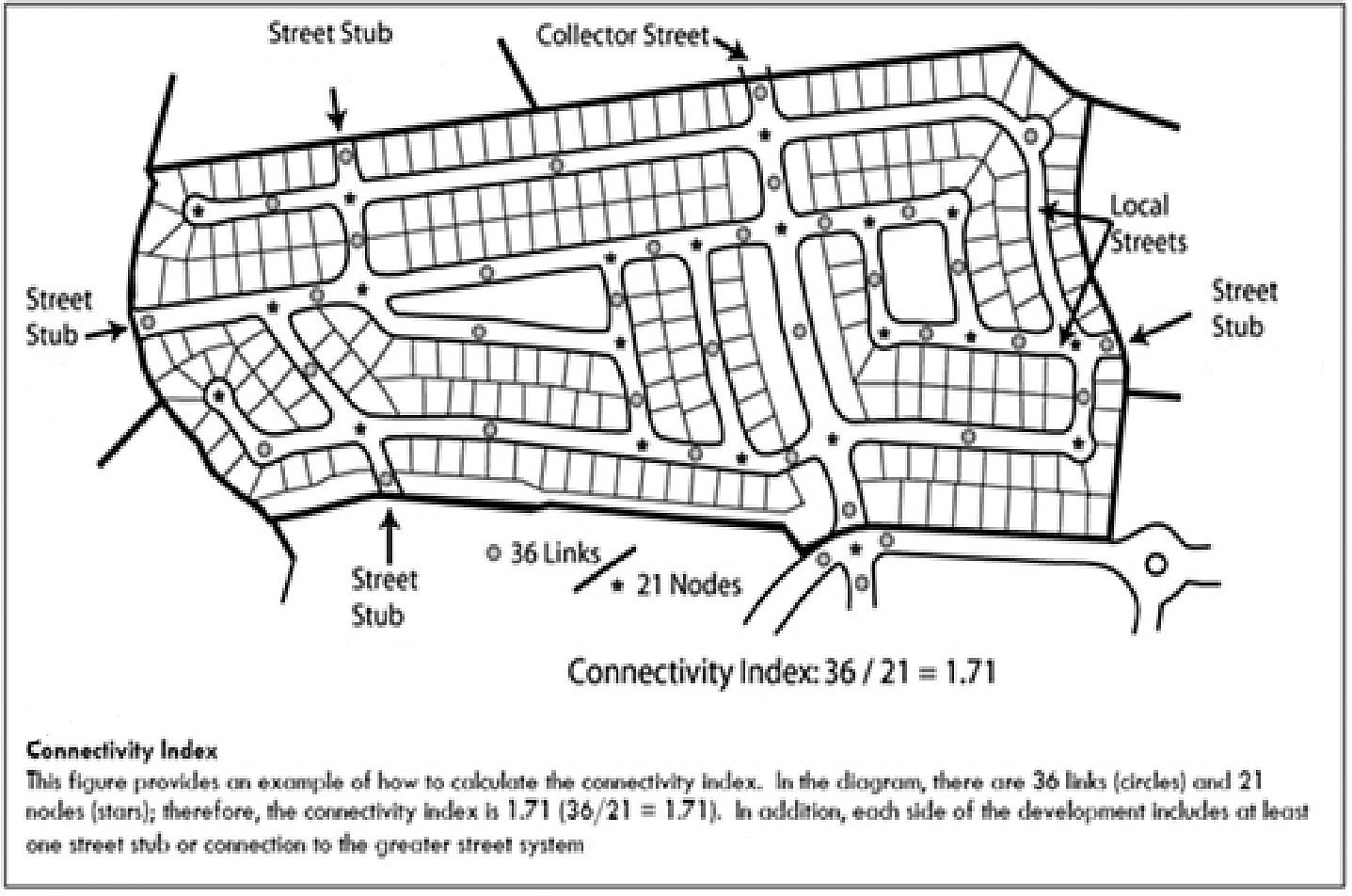
(3) Roadway Network Connectivity.
(a) All proposed developments must have a connectivity index of 1.4 or greater. The connectivity index shall be calculated by dividing the total number of links (streets including stub-out streets that connect nodes) by the total number of nodes (intersections, cul-de-sac, no-outlets, dead-ends).
(b) The decision-making authority may grant exceptions to these requirements only upon a finding that the development is constrained by topographic features, existing development or other impassable features.
(c) Street Right-of-Way Dedication. Street right-of-way dedications may be required as a condition of subdivision, short plat, or binding site plan.
(d) Street Construction. All streets and thoroughfares providing access to a proposed subdivision, short plat, or binding site plan shall be constructed and paved to city standards and within rights-of-way in accordance with the adopted PWESS, city’s transportation plan, and other adopted city standards.
(e) Intersection Improvements and Traffic Control Devices. Intersection improvements may be required to ensure public safety as a condition of subdivision, short plat, or binding site plan and shall be designed and improved in accordance with the city’s transportation plan, adopted PWESS and/or nationally recognized standards subject to city review and acceptance. Intersection improvements and/or traffic control devices shall be required only as a result of the findings of a traffic impact analysis reviewed and accepted by the city.
(f) Private Streets. See POMC 20.100.120, Private streets.
(g) Access Management on City Streets. Subdivisions, short plats, and binding site plans shall meet the access management standards found in the adopted PWESS.
(h) Access Management on State Highways. Subdivisions, short plats, and binding site plans shall meet WSDOT access management standards. (Ord. 011-19 § 5 (Exh. 2)).
20.100.030 Lot layout.
Lots to be created within a proposed subdivision, short plat, or binding site plan should comply with the following requirements:
(1) Lot lines should be at right angles to street lines or radial to curvilinear streets unless a variation will result in a better street or lot plan; and
(2) Corner lots should be graded to provide sufficient sight clearance at intersections. (Ord. 011-19 § 5 (Exh. 2)).
20.100.040 Street standards.
(1) Arrangement of Streets and Conformance to the City of Port Orchard Comprehensive Plan Transportation Element. Except as provided in subsection (1)(a) of this section, the city’s adopted transportation element shall be used to determine the minimum type of roadway, the general location of the roadway, and the areas that the roadway is intended to connect as part of the platting process. For streets that are not identified in the city’s transportation element, such as local residential streets, the arrangement of such streets within a subdivision shall:
(a) Conform to any plan for the neighborhood or subarea plan approved or adopted by the city to meet a particular situation where topographical or other conditions make continuance or conformity to existing streets impractical;
(b) Provide for future access, by stubbing streets for future extension, to adjacent vacant or undeveloped areas which will likely not have incompatible land uses; and
(c) Not conflict in any way with existing or proposed driveway openings (including those on the other side of an existing or planned median-divided arterial, in which case new streets shall align with such driveway openings such that median openings can be shared).
(2) Projections and Related Requirements. Where adjoining unsubdivided areas exist, the subdivision street arrangement shall make provision for projection of streets into such areas. Dead-end streets shall otherwise be prohibited, except where projections into unsubdivided land are necessary or where turnarounds are provided in accordance with POMC 20.100.080. Private streets shall not be allowed to project beyond the subdivision boundary, and therefore shall not be allowed to dead-end at the subdivision boundary.
(3) Transitions of Right-of-Way Width. Wherever the right-of-way width of a residential, local, collector or arterial street must transition to a greater or lesser width, the transition shall not occur within an intersection but within the street right-of-way so that the right-of-way shall be the same on both sides of the street intersection.
(4) Configuration Shall Reduce Minimal Offsets. Intersecting streets onto an existing or future divided roadway must be configured in accordance with POMC 20.100.100, Street offsets, such that the centerline offset will accommodate the appropriate median opening and left-turn lanes (with required transition and stacking distances) on each divided roadway, and shall be aligned with any existing or proposed streets or driveways on the opposite side of the divided roadway (in order to share the median opening). Median openings and offsets should be analyzed in the traffic impact analysis, and a determination made if developments sharing a median opening may cause additional traffic conflicts, where an exception to sharing a median opening may be made.
(5) Extensions of Existing Streets. New streets which extend existing streets shall bear the names of the existing streets and shall be dedicated at equal or greater right-of-way widths than the existing streets for an appropriate transition length, if applicable, unless a lesser street is justified by a TIA.
(6) Street Grades and Horizontal Curves. Minimum and maximum street grades and horizontal curves shall conform to standards set forth in the Engineering Standards and Specifications and the American Association of State Highway and Transportation Officials (AASHTO), or as otherwise approved by the city engineer.
(7) Street Signs. Street signs shall be installed by the developer at all intersections within and abutting the subdivision. These signs shall be of a type approved by the city, and shall be installed according to city standards and in conformance with the Manual on Uniform Traffic Control Devices.
(8) Streetlights. Streetlights shall be installed in accordance with the requirements set forth in the adopted PWESS.
(9) Pedestrian Connectivity. Pedestrian connectivity and access shall be provided between subdivisions, schools (where access is allowed by the school district), cul-de-sacs (i.e., bulb-to-bulb access), adjacent areas available for future development, and park and open space areas.
(10) Reserve Strips. Reserve strips controlling access to streets shall be prohibited except where their control is required by the city and approved by the approving authority. (Ord. 011-19 § 5 (Exh. 2)).
20.100.050 Intersections, half-streets.
(1) Intersections. Street intersections shall be situated at an angle of 90 degrees, plus or minus 15 degrees, except where the intersection utilizes knuckles, turning heels or eyebrows in accordance with the adopted PWESS. Such intersections shall maintain proper intersection visibility as determined by the latest edition of AASHTO’s “A policy on Geometric Design of Highways and Streets.” The major access driveway to large multifamily, commercial and industrial developments shall also meet the requirements of this chapter.
(2) Half-Streets. Construction of half-streets shall be prohibited, except when essential to the reasonable development of the subdivision, short plat, or binding site plan in conforming with the other requirements of this code and the transportation element, and where the decision-making authority makes a determination at the time of approval that there is no immediate benefit to be gained by constructing the full street section since no access from the street will be needed by the project in question. (Ord. 011-19 § 5 (Exh. 2)).
20.100.060 Street length.
(1) Length of a Block or Street Segment. The maximum length of any block or street segment (including a looped street) shall be 600 feet along arterial streets. Block faces shall not exceed 800 feet along other streets and the full perimeter of a block shall not exceed 2,400 feet except where topographic or critical areas features on parcels of one-half acre or larger would justify an exception from this requirement. Cul-de-sac streets shall adhere to Table 20.100.070(1) or other requirements herein. Measurements shall be measured along the centerline of the street from the centerline or center point of one intersection to the centerline or center point of the next intersection. For the purposes of measurement, either a full four-way intersection or a “T” three-way intersection shall be considered an intersection.
(2) Where significant topographic features or critical areas features are present, and will be retained on parcels of one-half acre or larger in size that are proposed for development, if one of the three options provided below are implemented within each block that exceeds 800 feet in face length or 2,400 feet in perimeter length, the street length standards in this section shall be considered met:
(a) Blocks containing retention or detention ponds;
(b) Blocks containing parks; or
(c) Development where the proposed development abuts the rear of an existing development and no rights-of-way have been provided.
(3) Maximum Length of a Cul-De-Sac Street.
(a) No cul-de-sac served by one access point in any single-family, multifamily, industrial, or commercial subdivision shall exceed 450 feet in length or the length as shown in Table 20.100.070(1), whichever is less.
(b) No cul-de-sac in any single-family subdivision district shall be designed to serve more than 25 single-family dwelling units, unless an exception is granted by the hearing examiner to the maximum length, in which case the maximum number of dwelling units shall be increased in the same percentage as the maximum length has been increased.
(c) For purposes of this subsection, cul-de-sac length shall be measured along the centerline of the cul-de-sac from a point beginning at the intersection of the cul-de-sac street with the centerline of the street from which it extends to the center of the turnaround at the end of such cul-de-sac. (Also see POMC 20.100.070 for cul-de-sac requirements.) For the purposes of measurement, either a full four-way intersection or a “T” three-way intersection shall be considered an intersection.
(d) An exception to the maximum cul-de-sac lengths may be granted by the decision-making authority to develop a parcel:
(i) With significant topographic constraints such as those documented in a geological report or where the resulting roadway would exceed a 12 percent grade;
(ii) With critical areas requiring protection on or adjacent to the parcel;
(iii) That is effectively landlocked with no other alternative than a cul-de-sac exceeding 450 feet;
(iv) Is in a proposed subdivision that has such a unique configuration that the only way to serve the area in question is with a cul-de-sac exceeding 450 feet. Such exception shall not be granted if the length of the cul-de-sac can be reduced by connection to an adjacent and/or parallel street. The desire to gain additional lots from the cul-de-sac exception by itself is not reason enough to grant such exception to the maximum length;
(v) Additional modifications may be required by the decision-making authority upon recommendation by the fire authority including intermediate turnarounds (eyebrows) to accommodate emergency vehicles being provided at a maximum distance of 300 feet;
(vi) Building construction within the area of the cul-de-sac beyond the 450 feet distance shall be fire sprinklered and a note shall be added to the recording plat and the subdivision improvement plans indicating that buildings are required to be sprinklered within the subdivision, and which lot numbers have such requirement.
(4) Cross-Reference. Also see POMC 20.100.070 for cul-de-sac requirements. (Ord. 033-20 § 9; Ord. 011-19 § 5 (Exh. 2)).
20.100.070 Cul-de-sac streets.
Except where projecting into adjacent unsubdivided areas, any street having only one vehicular access to another street shall be terminated by a permanent turnaround. Standards for both the turnaround and its street approach are set forth within this section. Exceptions to these standards shall be discouraged due to firefighting and solid waste collection requirements. Any turnaround, either temporary or permanent, that does not meet these requirements shall be permanently signed for no parking or marked as a fire lane in accordance with the adopted PWESS.
(1) That portion of any street extending from an intersection to a turnaround shall be improved and rights-of-way platted with the minimal dimensions provided in Table 20.100.070(1) below.
|
Activity Served |
Paving Width* |
Right-of-Way Width |
Additional Requirements |
|---|---|---|---|
|
Less than 12 dwellings |
20' |
45' |
300 feet maximum length |
|
12 – 25 dwelling units |
20' |
45' |
450 feet maximum length – Single-family, duplex only** |
|
Nonresidential zoning districts (except as otherwise specified) |
26' |
52' |
300 feet maximum length |
|
Industrial districts |
26' |
52' |
300 feet maximum length |
* Measured from the front of adjoining curbs.
** Cul-de-sacs (dead-end streets) serving triplex, quadraplex and higher density multifamily uses shall be discouraged. Exceptions may be granted by the hearing examiner where no alternative exists and meeting the industrial district’s standard or in infill development situations.
(2) The turnaround portion of any cul-de-sac shall be improved, and rights-of-way platted, as prescribed below:
|
Activity Served |
Paving Width* |
Right-of-Way Width |
|---|---|---|
|
Residential and nonresidential zoning districts (except as otherwise specified) |
90' diameter |
110' diameter |
|
Industrial districts |
96' diameter |
120' diameter |
* Measured to front of adjoining curbs.
(Ord. 050-22 § 9; Ord. 011-19 § 5 (Exh. 2)).
20.100.080 Dead-end streets.
Except when recommended by the department of community development, no public dead-end streets will be approved unless they are provided to connect with existing streets (including stubbed-out streets) or future platted streets on adjacent land.
(1) In the case of dead-end streets which will eventually be extended into the adjacent property, no more than one lot (per side) can front onto the dead-end street stub unless a temporary turnaround bulb (with the appropriate temporary street easement) is provided at the end.
(2) A temporary dead-end street shall not exceed the maximum allowed length of a normal cul-de-sac, and the temporary turnaround bulb must be constructed like a cul-de-sac, as provided in POMC 20.100.070, Cul-de-sac streets.
(3) A note shall be placed on the final plat, short plat, or binding site plan clearly labeling any temporary dead-end streets (if any) that will at some point be extended into the adjacent property. Any required temporary turnaround easements shall be shown on the final plat along with their appropriate recording information, if they are off site or established by separate instrument. (Ord. 011-19 § 5 (Exh. 2)).
20.100.090 Street width and design.
(1) Pavement Widths and Rights-of-Way. Pavement widths and design and rights-of-way shall be as designated in the adopted PWESS; provided, that for local access streets, the subdivision also meets the applicable block length requirements of POMC 20.100.060 and connectivity index in POMC 20.100.020.
(2) Design. Streets shall be designed according to the following requirements:
(a) Arterial. Streets shall be designed to accommodate cross-city traffic movement, distributing traffic to and from collector streets;
(b) Collector. Streets shall be designed to collect traffic from local streets and connect with arterial streets and freeways;
(c) Residential Collector. Generally, the term “subcollector” shall refer to streets designed to accommodate traffic movement from local streets to higher classifications of streets as well as provide direct access to activity on individual lots. Specifically, a subcollector may be defined as any street or portion thereof providing direct access to property within commercial or industrial districts as designated on the official zoning map of the city of Port Orchard, any street or portion thereof providing the shortest direct route to a collector street for 25 dwelling units or more, or any street segment extending without offset from a collector street and connecting two or more collector streets. Where subcollector streets are terminated by a permanent turnaround, standards for street width and paving shall be as described in the engineering standards and specifications;
(d) Local. Streets shall be designed to provide direct access to residential activity, and in such a way as to encourage connectivity of the roadway network, but discourage cut-through traffic. (Ord. 011-19 § 5 (Exh. 2)).
20.100.100 Street offsets.
Intersection Offsets. Where parallel streets intersect another street, the centerline of those streets shall be offset a minimum of 120 feet, unless a stricter standard is adopted in a subarea or corridor plan. (Ord. 011-19 § 5 (Exh. 2)).
20.100.110 Curbs and gutters.
Curbs and gutters shall be installed according to the provisions of this chapter and to the adopted PWESS. Combination curb and gutter improvements shall be provided to mark the edge of pavement and carry surface water, as set forth below:
(1) Beside Arterial and Collector Streets. The subdivider shall install curbs on both sides of all arterial and collector streets within the subdivision, and on one side of all such streets along the subdivision frontage.
(2) Beside Local Streets. The subdivider shall install curbs on both sides of all local streets within the subdivision and at subdivision boundaries, except for existing boundary streets, in which case curb and gutter installation shall be required on the subdivision’s frontage only.
(3) At Street Intersections. The minimum curvature of curbs at street intersections shall be as prescribed in the adopted PWESS and shall maintain proper stopping sight distance as determined by the latest edition of AASHTO’s “A policy on Geometric Design of Highways and Streets.” (Ord. 011-19 § 5 (Exh. 2)).
20.100.120 Private streets.
(1) Permitted Only as Local Street. Private streets shall require approval as an exception at the time of preliminary plat approval by the hearing examiner in accordance with this title. No streets or thoroughfares shown in the adopted city of Port Orchard comprehensive plan may be a nonpublic street. Construction and development of private streets shall meet the standards for right-of-way width and improvement as set forth in this chapter as applied to public streets.
(2) Classification. At the time a private street is proposed, it shall be classified as either a local access or subcollector street, as described herein, and made to conform in all respects with right-of-way paving, curb and gutter, construction, and design requirements as applicable to a public street.
(3) Subdivision Boundary Streets. New subdivision boundary streets (streets proposed or constructed along a subdivision perimeter boundary) shall not be private.
(4) Private Streets, General. In order to be considered for an exception to allow the construction of private streets, the developer shall meet the requirements set out in this section.
(a) Construction. All private streets shall be designed, constructed, and maintained to meet city standards. The construction and improvement plans shall be reviewed by the city in the same manner as construction and improvement plans for public infrastructure. The city shall not participate in any portion of the cost of constructing a private street.
(b) Inspection During Construction. All private streets shall be subject to inspections by city staff in the same manner, at the same intervals, as public streets, including the payment of applicable inspection fees. A construction schedule shall be submitted with the construction and improvement plans in order to assist in scheduling the inspections. Failure to pass an inspection and meet city construction standards shall require reinspection, and reconstruction, as necessary. No certificates of occupancy shall be released for structures along a private street until all inspections shall have been completed satisfactorily.
(c) Traffic Control Devices. All private traffic control devices and regulatory signs shall conform to the “Manual of Uniform Traffic Control Devices,” as amended, and to city standards.
(d) Restricted Access. The subdivision homeowners association shall clearly mark entrances to all private streets with a sign, in accordance with the adopted PWESS, placed in a prominent and visible location, indicating that the streets within the subdivision are private, and not maintained nor regularly patrolled by the city. All restricted access entrances shall be manned 24 hours every day, or they shall provide a reliable, alternative means of ensuring access into the subdivision by the city, by emergency service providers, and by other utility or public service providers, such as postal carriers and utility companies, with appropriate identification. The method used to ensure city and emergency access into the subdivision shall be approved by South Kitsap Fire and Rescue and by any other applicable emergency service providers during the final platting process. Gates on private streets shall provide a traffic queue analysis and provide adequate on-street storage in advance of the gate. If the homeowners association fails to maintain reliable access as required by city codes, the city may enter the private street subdivision and remove any gate or device that is a barrier to access, and bill the expense to the association. If the bill is not paid, the city may file a lien for the expense against any property owned by the association.
(e) Waiver of Services. Certain city services may not be provided for private street subdivisions, including street maintenance, routine law enforcement patrols, enforcement of traffic and parking regulations, preparation of accident reports, and payment of costs for street lighting. A note as to waiver of services may be required on the face of the plat.
(f) Street Lighting. Street lighting as required by this title shall be entirely at the expense of the developer and subsequent property owners. Decorative poles or alternative spacing may be approved by the city engineer, who shall make such recommendation based on the lighting type, the lumens necessary to effectuate safe traffic and pedestrian travel, and a finding that the proposed lighting plan provides as well or better for the health, safety and welfare of the future residents of the private street subdivisions.
(g) Maintenance. The developer shall provide for the establishment of a homeowners or property owners association, in covenants, conditions, and restrictions (CCRs), to assume the obligation of perpetual maintenance of private streets and other improvements held privately, including a mandatory assessment for such private streets and improvements to be placed on all property owners within the subdivision, allowance for city staff to inspect the streets to assure they are being maintained to city standards, hold harmless provisions as required in subsection (5) of this section, and providing for notice to the city attorney and city manager of any amendments to these relevant sections. The city shall be a necessary party for the amendment of any portions of the CCRs dealing with these requirements. The proposed CCRs shall be submitted for review by the city attorney at the time of filing the preliminary plat. The city attorney shall review the CCRs to ensure that the requirements of this section are met, and shall submit recommended changes to the developer, who shall incorporate such changes. Absence of city attorney approval of the CCRs shall require the denial of the exception for private streets.
(h) Petition to Convert to Public Streets. A property owners association may petition the city to accept private streets and any associated property as public streets and right-of-way upon written notice to all association members, and the favorable vote of a majority of the membership, or as required in the CCRs. A dedication instrument shall also be submitted, and shall be reviewed and the final form approved by the city attorney prior to submission of this request to city council.
The city shall not be required to accept any private streets for public dedication and maintenance. The staff shall review the request and make a recommendation to city council. City council shall make their decision based on the public health, safety and welfare considerations of the streets. As a condition of accepting the dedication and maintenance of private streets, the city may impose a requirement for repairs and improvements at private expense prior to acceptance, enter into an agreement for an assessment or pro-rata sharing of costs for repairs or improvements prior to acceptance, or other legal or equitable options to ensure that the streets being accepted are not a liability to the city. The city shall be the sole judge of the nature and extent of repairs or improvements needed. The city may also require, at the sole expense of the association’s or property owner’s expense, the removal of any guard houses, access control devices, landscaping or other amenities located within the streets or common areas prior to city acceptance.
(5) Hold Harmless. The property owners association, as owner of the private streets and appurtenances, shall release, indemnify, defend and hold harmless the city, any other governmental entity, and any public utility entity for damages to the private streets that may be occasioned by the reasonable use of the private streets by same, and for damages and injury (including death) arising from the condition of the private streets, out of any use of access gates or cross arms, or out of any use of the subdivision by the city or governmental or utility entity. (Ord. 011-19 § 5 (Exh. 2)).
20.100.130 On-site recreation space for subdivisions.
(1) Purpose. The purpose of this chapter is to ensure that adequate, usable, passive and active recreational opportunities are provided for residents of new subdivisions.
(2) Applicability. On-site recreation space shall be provided for new residential subdivisions consisting of 10 or more new dwellings. The establishment of backyard cottages or accessory dwelling units shall not trigger requirements for additional on-site recreation facilities when those building types are constructed within an existing subdivision.
(3) On-Site Open Space Quantity Requirements.
(a) On-site recreation space shall be provided in accordance with Table 20.100.130(3).
|
Number of Dwelling Units in Subdivision |
Amount of On-Site Recreation Space Required per Each Dwelling Unit |
|---|---|
|
10 – 40 |
300 sq ft |
|
41 – 100 |
250 sq ft |
|
Units over 100 |
150 sq ft |
*To illustrate the implementation of Table 20.100.130(3), a 110-lot subdivision would require 300 square feet of open space per unit for the first 40 units, 250 square feet of open space for the next 60 units, and 150 square feet of open space for the final 10 units. (40*300)+(60*250)+(10*150)= 28,500 square feet of required open space for a 110-lot subdivision.
(b) The requirements in Table 20.100.130(3) may be reduced by up to 50 percent for residential development that is located within one-quarter mile walking distance of a public park. The director shall determine the amount of reduction based on the following:
(i) The availability of safe pedestrian facilities connecting the development to the park;
(ii) The ability of the park facilities to accommodate additional usage by residents of the development; and
(iii) The number of park facilities located within one-quarter-mile distance.
(4) On-Site Open Space Design.
(a) On-site recreation open space shall be designed as follows:
(i) On-site recreation open space shall be located in a separate tract from the residential dwellings; shall have an undivided ownership interest by the homeowners of the development; and shall have a deed restriction recorded for the tract that restricts the use of the tract to recreational uses;
(ii) At least 40 percent of the total required on-site recreation open space shall be consolidated in one location within the development;
(iii) At least 75 percent of the total required on-site recreation open space shall be located outside of critical areas other than buffers identified in Chapter 20.162 POMC;
(iv) On-site recreation open space shall be developed for active and passive uses. At least 50 percent of the on-site recreation open space shall be designed and improved for one or more active uses. When an area of on-site recreation open space is designed and improved for active uses other than improved pedestrian or bicycle paths with hard surfaces, the average width of the area shall be at least equal to half of the average length of the area. Active uses include, but are not limited to:
(A) Playgrounds developed with children’s play equipment;
(B) Improved pedestrian or bicycle paths with hard surfaces;
(C) Sports fields (such as soccer or softball fields), with associated improvements;
(D) Indoor or outdoor sports courts (such as volleyball, basketball or tennis courts), swimming pools, and similar facilities;
(E) Picnic areas with permanent tables, benches or gazebos;
(F) Community clubhouse and meeting facilities;
(G) Community gardens for use by the residents;
(H) Plazas with lighting, artwork, and sitting space for pedestrians at four or more spaces for every required 100 square feet of area; and
(I) Other similar uses approved by the director;
(v) Passive uses include critical areas that cannot be developed, nature interpretive areas, bird watching facilities, unimproved trails, and similar uses approved by the director;
(vi) The following drainage facilities may be counted as on-site passive recreation space:
(A) Unfenced detention, retention and wet ponds; provided, that pathways and viewing areas surround the pond;
(B) Stormwater treatment wetlands;
(C) Stormwater infiltration trenches and bioswales that serve more than one dwelling; and
(D) Vegetated areas located above underground detention facilities;
(vii) No on-site recreation open space tract shall contain less than 700 square feet in area;
(viii) On-site recreation open space shall have at least 50 feet of frontage on a public right-of-way or private street tract;
(ix) All recreation open space tracts shall be developed, landscaped and maintained so that a high level of visibility is provided from the public right-of-way or private street tract to playgrounds and other areas intended primarily for use by children;
(x) If a single active on-site recreation open space tract is provided, it shall be centrally located within the subdivision, so that it is within one-quarter-mile walking distance for at least 90 percent of the dwelling units. If the subdivision area is too large for this standard to be met with one recreation open space tract, an additional recreation open space tract or tracts shall be required;
(xi) Access for pedestrians shall be provided from all dwellings within the development to the on-site recreation space through trails, sidewalks, pathways and other similar means of access; and
(xii) On-site recreation space shall not include privately owned yards. (Ord. 030-19 § 2).