


20C.45.40 Site Requirements.
20C.45.40-010 Explanation of Chart.
This division establishes the basic site requirements for Overlake districts. The chart contains the minimum and maximum dimensional requirements for each district. The footnotes identify particular requirements applicable to a specific use or district. See RCDG 20C.45.70-040 for site requirements for the Overlake Design District. (Ord. 2493; Ord. 2385; Ord. 2383)
20C.45.40-020 Site Requirements Chart – Overlake Districts.
|
|
Overlake Village Design District (OV) |
Overlake Business and Advanced Technology (OBAT) |
|
Maximum Lot Coverage of Structures and Impervious Surface1, 2 |
85% |
80% |
|
Minimum Landscaped Area |
15% See RCDG 20C.45.40-040 |
20% See RCDG 20C.45.40-040 |
|
Maximum Building Height (Stories), without Use of Bonuses or Transfer of Development Rights3, 4 |
|
|
|
Nonresidential Uses |
4 |
4 |
|
Residential Uses in Single-Use or Mixed-Use Buildings |
5 |
5 |
|
Maximum Floor Area Ratios without Use of Bonuses2, 5, 6, 7 |
|
|
|
Nonresidential Uses |
0.3611 |
0.40 |
|
Nonresidential Uses with Use of TDRs8 |
0.41 |
0.4712 |
|
Nonresidential Uses as Part of Mixed-Use Developments with 50% Residential Uses9, 10 |
0.41 |
|
|
Residential Uses9 in Single-Use or Mixed-Use Buildings |
2.5 |
1 |
|
Commercial Floor Area |
The total commercial floor area permitted within Overlake shall not exceed the Bellevue Redmond Overlake Transportation Study Agreement (BROTS) or its successor agreement. |
The total commercial floor area permitted within Overlake shall not exceed the Bellevue Redmond Overlake Transportation Study Agreement (BROTS) or its successor agreement. |
|
Building Setbacks |
|
|
|
Front and All Side Streets (in feet) |
Buildings shall be developed to the back of the setback zone13 along front and side streets, except north of the SR 520 eastbound off-ramp the minimum front and all side street setbacks shall be 10 feet.
See RCDG 20C.45.40-070, Overlake Street Cross Sections |
Minimum of 10 feet14, 15
See RCDG 20C.45.40-070, Overlake Street Cross Sections |
|
Minimum Side Setback (in feet) |
0 |
20 feet16 |
|
Minimum Rear Setback (in feet) |
0 |
20 feet16 |
|
Pedestrian Standards |
See RCDG 20C.45.40-080 |
See RCDG 20C.45.40-080 |
|
Ground Floor Uses |
See RCDG 20C.45.40-090 |
|
|
Minimum Residential Floor Area |
See RCDG 20C.45.40-100 |
|
|
Residential Open Space |
See RCDG 20C.45.40-110 |
See RCDG 20C.45.40-110 |
|
Parking |
See Chapter 20D.130 RCDG |
See Chapter 20D.130 RCDG |
1 See RCDG 20C.45.40-030, Maximum Lot Coverage – Structures and Total Impervious Surface.
2 For properties under a common ownership that are contiguous or separated only by rights-of-way, FARs may be calculated based on the average FAR across those properties, and density and impervious surface coverage may be transferred among contiguous properties, provided the averages or transfers are consistent with all other applicable regulations.
3 See RCDG 20C.45.40-050, Building Height; Chapter 20D.200 RCDG, Transfer of Development Rights (TDR) Program; and RCDG 20C.45.50, Overlake Village Subarea Incentive Program.
4 Maximum building height for properties in the portion of the Overlake Village Design District located north of the eastbound SR 520 off-ramp at 148th Avenue NE is five stories. This height may not be exceeded through the use of transfer of development rights or bonuses.
5 All legal lots are allowed the greater of either the maximum allowed FAR or 10,000 square feet of buildings, provided all other applicable site requirements are met.
6 The FAR for nonresidential and residential uses within a given development are individually calculated and may be added together for a cumulative total, provided that the respective maximum FAR for each use is not exceeded, unless otherwise provided in the RCDG.
7 See RCDG 20C.45.50, Overlake Village Subarea Incentive Program.
8 See Chapter 20D.200 RCDG, Transfer of Development Rights (TDR) Program.
9 Residential uses include living areas, common areas used to access living areas, offices for renting, leasing, or selling the housing units in the development, and recreational areas used exclusively by residents and their guests.
10 Proposed developments in the Overlake Village Design District that include residential uses as a minimum of 50 percent of the total amount of gross floor area are allowed the greater of: (1) a nonresidential FAR of 0.41, or (2) to retain an allowance for the total amount of nonresidential floor area existing as of December 11, 2007.
11 Hotel uses in the Overlake Village Design District may be developed to 1.2 FAR. On sites that contain both hotel and nonhotel nonresidential uses, the combined FAR of the hotel and nonhotel nonresidential uses shall not surpass the applicable maximum hotel FAR and the FAR of the nonhotel nonresidential uses shall not surpass the applicable maximum nonresidential FAR.
12 Building space to be used exclusively for day care centers may be constructed at a 0.47 FAR without the requirement to purchase TDRs, provided the building space is permanently used exclusively for a day care center and deed restrictions limit the building space to this purpose.
13 The setback zone is shown in RCDG 20C.45.40-070, Overlake Street Cross Sections. It is located outside of the right-of-way, and ensures that objects do not encroach on usable sidewalk space and helps to maintain sight lines at driveways. In the Overlake Village Subarea, it provides space for hardscape improvements or container plants. In the OBAT District, it provides space for plantings. It is also described in Redmond’s Transportation Master Plan – Pedestrian Program.
14 Measured from property line.
15 Along both sides of 156th Avenue NE (NE 40th Street to NE 28th Street), west side of 156th Avenue NE (NE 51st Street to NE 40th Street), both sides of NE 40th Street (148th Avenue NE to 156th Avenue NE), both sides of NE 51st Street (148th Avenue NE to SR 520), and south side of NE 51st Street (SR 520 to 156th Ave NE), the maximum building setback is 45 feet measured from the property line. Parking and driveways parallel to the street shall be prohibited in the setback.
16 Subject to landscaping and buffering requirements of Chapter 20D.80 RCDG, Landscaping and Tree Protection.
(Ord. 2493; Ord. 2385; Ord. 2383)
20C.45.40-030 Maximum Lot Coverage – Structures and Total Impervious Surface.
(1) General Requirement. Maximum lot coverage indicates the maximum percentage of the land that can be developed and covered with structures (including outdoor storage) and other impervious surfaces, such as parking lots, sidewalks, and plazas.
(2) Modifications. As part of an approved binding site plan, subdivision or planned commercial development, the Technical Committee may allow increased maximum impervious surface limits on individual lots within a multi-lot development, provided that the total amount of impervious surface for the entire development does not exceed that set forth by the Site Requirements Chart. If a modification is approved, the development shall be conditioned and recorded with the property’s title to ensure compliance with the total impervious surface limits set by the Chart. (Ord. 2493; Ord. 2385; Ord. 2383)
20C.45.40-040 Landscaping.
(1) General Requirement. All setbacks, buffers, open spaces, pervious surfaces, plazas, parks, site and building entrances, pedestrian walkways, service areas and parking lots shall be landscaped with plant materials. Existing vegetation may be maintained and applied toward this standard if the existing vegetation is desirable. The requirements specified in RCDG 20D.40.35, Landscape Design Standards, and RCDG 20D.80.10, Landscaping and Natural Screening, shall apply as applicable. In addition, supplemental landscaping requirements for the Overlake districts are defined below.
(2) Plantings Along Streets. At a minimum, planting strips along streets shall include street trees per the City’s standards for type and species. Where space allows, planting areas should include other vegetation suitable for an urban setting. Tree planting pits on streets that include furniture zones per RCDG 20C.45.40-070, Overlake Street Cross Sections, shall be covered with cast iron tree grates of a type that meets ADA requirements.
(3) Overlake Village Design District and Overlake Design District – Open Space and Plazas.
(a) Plazas and common usable open spaces shall be landscaped to create visual interest, soften building edges, and reduce the impact of adverse elements such as noise or wind.
(b) The quantity of trees, shrubs and other plant materials shall be designed to meet the size and function of the plaza or open space, and is subject to approval by the Technical Committee.
(4) Overlake Village Design District – Buffers.
(a) Properties in the Overlake Village Design District located north of the eastbound SR 520 off-ramp at 148th Avenue NE shall provide a landscape buffer at least 20 feet in width along street frontages where any portion of the street bordering the development site borders a residential zone within a neighboring jurisdiction.
(b) The provisions in subsections (5)(b) through (e) of this section apply.
(5) Overlake Business and Advanced Technology District Requirements – Buffers.
(a) Landscape buffers at least 20 feet in width shall be provided in the following locations:
(i) Along property lines which border a single-family or multi-family residential zone within Redmond or a neighboring jurisdiction.
(ii) Along street frontages where any portion of the street bordering the development site borders a single-family residential zone within Redmond or a neighboring jurisdiction. “Single-family zone” is defined as a zone with an allowed density of eight or fewer dwellings per acre.
(b) The buffers shall be planted with the following materials:
(i) Minimum of one tree per 200 square feet of buffer area. No more than 40 percent of trees may be deciduous.
(ii) Evergreen shrubs, a minimum of five gallons in size. The area covered by the shrubs shall equal at least one-third of the buffer frontage.
(iii) Groundcover plantings to cover the ground within three years.
(iv) Plant materials shall be native to the area. The Code Administrator may allow substitutions of nonnative plant materials that are drought tolerant, provided the buffer remains primarily in native materials.
(v) The trees and other plant materials required by this section shall be located so that they effectively buffer the development from bordering residential properties. The buffer need not completely obscure the development; rather, it should screen it.
(c) Up to 20 percent of the buffer area may be used for streets, driveways, utility crossings, trails or ground level features such as patios. Other structures may not be placed in required buffers.
(d) All required buffers shall be maintained in compliance with this section for the life of the use. Dead and dying plants shall be replaced during the next growing season.
(e) Buffers may be counted towards required open space, required pervious surfaces, setbacks and other requirements that they meet.
(6) Overlake Business and Advanced Technology District – Supplemental Buffer Requirements.
(a) Purpose. The purpose of the supplemental buffer requirements is to protect nearby uses from the potential adverse impacts of more intense uses due to noise, glare, and the scale of development in locations where the lots are large enough for greater buffers than required by other provisions of the Redmond Community Development Guide. The 100-foot greenbelt along Bellevue-Redmond Road is to provide a complete visual barrier. The buffers along NE 28th Street, NE 40th Street, NE 60th Street and Bridle Crest Trail, and 148th Avenue NE are to screen the uses across these streets and trails from the buildings, uses, and activities adjacent to the buffer.
(b) Bellevue-Redmond Road Greenbelt.
(i) A greenbelt buffer 100 feet wide shall be provided and maintained along the portion of Bellevue-Redmond Road shown on the Height and FAR Limit Overlay Map as a height limit area. The greenbelt buffer shall border the Bellevue-Redmond Road right-of-way, and the width shall be measured at right angles to the right-of-way. If the right-of-way expands in the future due to purchases, dedications, the granting of easements, or any other means, the buffer shall also expand, except that the buffer shall not expand into any buildings, above-ground structures, parking areas, vehicle use areas, or other constructed surfaces inconsistent with a buffer that exist at the time of the expansion.
(ii) Notwithstanding any other provision of this title, the 100-foot greenbelt along the portion of Bellevue-Redmond Road identified in subsection (6)(b)(i) of this section shall be planted and maintained so that it blocks vision from the unaided human eye through the greenbelt along both sides of Bellevue-Redmond Road from ground level to a height of 55 feet above the ground surface. This greenbelt shall consist of an evergreen canopy, a middle story of deciduous and evergreen trees, and an understory of shrubs, plants, and smaller trees. While the plants shall be primarily of types native to the area, soils and micro-climate, nonnative ornamental plants may also be included.
(c) Buffers Adjacent to NE 28th Street and NE 40th Street.
(i) A 50-foot-wide buffer shall be provided and maintained along the north side of NE 28th Street between 156th Avenue NE and Bellevue-Redmond Road. If NE 28th Street is ever vacated, the buffer may remain along the former NE 28th Street right-of-way or be moved south to the new property line created by the vacation.
(ii) A 50-foot-wide buffer shall be provided and maintained along the south side of NE 40th Street between 159th Avenue NE and a north-south line 300 feet east of the northwest corner of Section 24, Township 18 N, R 5 E.W.M. and parallel to the west section line of said section. If 159th Avenue NE is ever vacated, the buffer shall run to the former right-of-way of said street.
(d) Redmond West Buffers. The Redmond West covenants, conditions, and restrictions provide for a 200-foot buffer along 148th Avenue NE and a 50- to 75-foot-wide buffer along the north boundary of the property. These buffers shall be maintained as follows:
(i) A vegetative buffer shall be provided and maintained along 148th Avenue NE extending approximately 200 feet east from the property line.
(ii) A continuous vegetative buffer shall be provided and maintained along the Bridle Crest Equestrian Trail (south of the 60-foot former NE 60th Street right-of-way) between 148th Avenue NE and SR 520. The buffer shall be 75 feet wide south of the property line abutting the plat of Sunrise Park, 50 feet wide south of the property line abutting Benjamin Rush Elementary School, and 75 feet wide south of the property line abutting the existing NE 60th Street right-of-way. A minimum 10-foot-wide berm plus additional landscaping and a fence separating the equestrian trail and buffer shall be maintained. The existing standing fir trees in the northeast corner of the site adjacent to SR 520 and NE 60th Street shall be maintained as a buffer for noise and views. The 75-foot buffer will be extended as needed to encompass the majority of the tree stand.
(iii) Existing mature trees within the buffers and open space shall be retained when possible. Berms within the buffer and open space areas should be planted with a mixture of medium scale evergreen trees and shrubs to provide additional visual buffering to nearby properties.
(e) The greenbelts and buffers provided for in this section shall comply with the applicable requirements of Chapter 20D.80 RCDG, Landscaping and Tree Protection, and RCDG 20D.230.30-060, Landscaping and Buffers in a Transition Overlay, except as specifically provided by this section. (Ord. 2493; Ord. 2385; Ord. 2383)
20C.45.40-050 Building Height.
(1) General Requirement. Maximum height requirements set the limit measured from the finished grade above which structures shall not extend without use of bonuses or transfer of development rights. In the Overlake Village Design District, Overlake Design District and Overlake Business and Advanced Technology District, heating, cooling, and ventilation equipment, elevator penthouses, rooftop exits and flagpoles may exceed the height limit by not more than 15 feet. In the Overlake Business and Advanced Technology District, antennas and chimneys may exceed the height limit by not more than 15 feet. Refer to Chapter 20A.20 RCDG, Definitions, Height of Building or Structure, for measuring building height.
(2) Height Tradeoff. The maximum building height on a site may be exceeded, as a tradeoff, when building height reductions are required at building edges, along a street or park, to achieve better design and stepped building height through the design review process. The amount of floor area that is allowed to exceed the prescribed maximum building height (without use of bonuses or transfer of development rights) shall not exceed the floor area that was removed or omitted to create the stepped building facade and shall not exceed one additional floor above the prescribed maximum building height.
(3) Height Bonuses.
(a) Maximum building height may be increased by one floor through the use of transfer of development rights per Chapter 20D.200 RCDG, Transfer of Development Rights (TDR) Program, unless otherwise provided in the Redmond Community Development Guide.
(b) See also RCDG 20C.45.50, Overlake Village Subarea Incentive Program, for applicable height and floor area bonuses.
(4) Height and FAR Limit Overlay – Overlake Business and Advanced Technology District.
(a) Purpose. This section establishes special limits for structures located in the Overlake Business and Advanced Technology (OBAT) District as shown on the Height and FAR Limit Overlay Map. The intent of this requirement is to promote compatibility on the edges of zones that allow more intense uses than abutting zones and to minimize adverse impacts such as glare and noise.
(b) Requirements.
(i) The Height and FAR Limit Overlay Map shows limits on maximum height and maximum FAR for structures located within 300 feet of the OBAT District boundary with lower intensity zones.
(ii) Forty-Five-Foot Height Limit and FAR Overlay.
(A) Within this overlay, maximum structure height shall be 45 feet or three stories, whichever is lower.
(B) The maximum FAR shall be 0.30 for any building located within or partially within this overlay. The amount of floor area allowed by the OBAT District that exceeds a FAR of 0.30 may be used on any property zoned OBAT that is contiguous to and in the same ownership as the properties within this overlay.
(iii) Thirty-Five-Foot Height Limit Overlay.
(A) Within this overlay, maximum structure height shall be 35 feet.
(B) The maximum structure height may be increased up to 45 feet if one or more of the following features are provided:
1. At least one quarter of the on-site parking is provided in underground parking structures.
2. No mechanical equipment is located on the roof.
3. The existing grade under the proposed structure pad is at least 10 feet below the grade at the property lines of all properties that border or are across the street from the development site.
4. Transfer of development rights are used to increase structure height.
(5) The Design Review Board may further increase the allowed structure height within this overlay if the following conditions are met:
(a) The modified building height does not exceed the maximum height permitted by the underlying zone as shown in RCDG 20C.45.40-020, Site Requirements Chart – Overlake Districts.
(b) The proposal with the height allowance will provide an equivalent or better transition to lower height residential zones as the limit imposed through the height overlay. The Design Review Board may consider:
(i) Landscape features such as retention or enhancement of vegetation;
(ii) Building design features such as massing or roofline;
(iii) Site design features such as use of landscaped berms; or
(iv) Other features that meet the intent of this section.
(c) The Design Review Board shall make its determination of whether to allow a further increase to the allowed structure height during pre-application review if in the Board’s determination the applicant has provided sufficient information on the alternative proposal with the height allowance.
Height and FAR Limit Overlay Map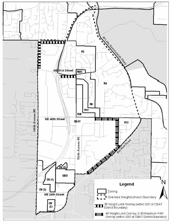
(Ord. 2385; Ord. 2383)
20C.45.40-060 Building Setbacks.
(1) Lot Orientation. For the purpose of applying setback regulations, the following shall be applied: the front shall be toward the public street, private street or access corridor from which the lot is addressed or which provides the primary access; the rear is opposite to the front or as nearly so as the lot shape permits; and the sides are 90 degrees to the front or as nearly so as the lot shape permits.
(2) Measurement. Setbacks shall be measured at right angles, or as near to right angles as possible, in a plane horizontal to the ground from the point of measurement as defined in RCDG 20C.45.40-020, Site Requirements Chart – Overlake Districts, Building Setbacks. In the case of access corridors and private streets, setbacks are measured from the inside edge of the access corridor or street to the foundation line of the structure.
(3) Setback Exceptions. Upon the presentation of a binding site plan, an approved site plan, or planned commercial development application, setbacks may be modified as follows: side setback distances may be modified to permit a zero side setback to accommodate joint wall construction and clustering of buildings; front setbacks may be modified from private streets and access corridors, provided front setbacks are maintained from all public streets.
(4) Improvements. Improvements less than 30 inches above grade, including decks, patios, walks and driveways, are permitted in setbacks. Fences, landscaping, flagpoles, street furniture, transit shelters and slope stability structures are permitted in setback areas, provided that all other applicable requirements are met. No other structures, including accessory structures, are permitted in setback areas.
(5) Neighborhood Protection Setbacks. Additional setbacks applicable to properties within the Overlake Business and Advanced Technology District are as follows:
|
Property Location |
Building Height |
Setback from the Property Line |
|
148th Avenue NE, between SR 520 eastbound off-ramp and NE 60th Street |
Up to 20 feet
21 feet or more |
20 feet
30 feet |
|
Along the portion of Bel-Red Road between Redmond City Limits (at NE 28th Street) and East Boundary for Overlake Business and Advanced Technology District |
All buildings |
120 feet |
(Ord. 2385; Ord. 2383)
20C.45.40-070 Overlake Street Cross Sections.
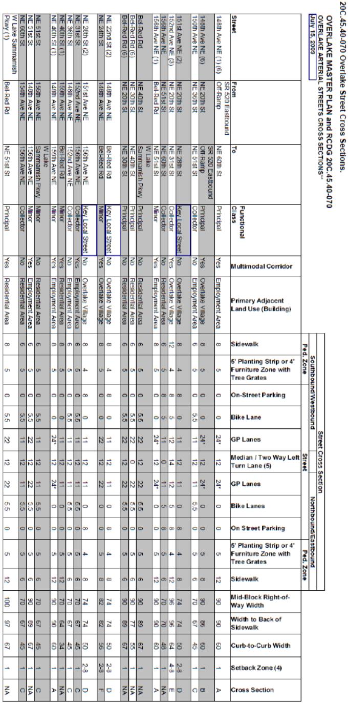
(1) Separate shared-use path parallel to corridor.
(2) New connection.
(3) Light rail in the corridor would result in the removal of the median and on-street parking.
(4) Setback applies to both sides and is provided outside of the right-of-way. The setback in the Overlake Village would be for hardscape improvements and courtyards. In other areas the one-foot setbacks are plantings. This is consistent with the Transportation Master Plan (TMP).
(5) Provisions of medians and left turn lane access will need to be determined on a project-by-project basis, based on traffic speeds, volumes and collision history.
(6) Street section shared by Bellevue and Redmond.
* Outside lane 13 and inside lane 11.
Guidelines:
– Include a minimum project length where standard would be applied. In cases shorter than the minimum, necessary right-of-way would be dedicated for future project to implement standard.
– When designing intersections refer to the Pedestrian Program Plan and Bicycle System Plan chapters of the TMP and other established design guidelines and standards.
– Minimum receiving lane width is 13 feet in Overlake Village area and other areas where streets have one lane in each direction and the use of curb bulbouts are planned.
– In Overlake Village utilities, such as power, telephone and cable, would be placed under the sidewalk, while in the Employment and Residential areas they would be placed in an easement behind the sidewalk.
– When designing multimodal corridors refer to the Modal Integration section of TMP. Corridors should support all modes, including transit, which impacts intersection and corridor design.
– In limited circumstances involving abnormally short lengths of property frontage, and at the sole discretion of the Public Works Director, a determination may be made that due to the short length of the frontage improvements coupled with a significant difference between the existing and planned street width/curb alignment, a development may be permitted to dedicate the required right-of-way and pay to the City the estimated cost of the frontage improvements in lieu of constructing the required frontage improvements.
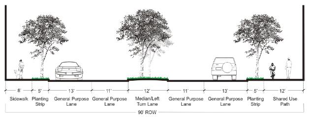
Street Cross Section A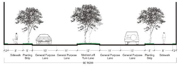
Street Cross Section B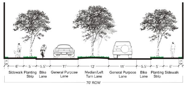
Street Cross Section C
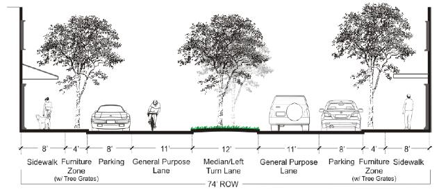
Street Cross Section D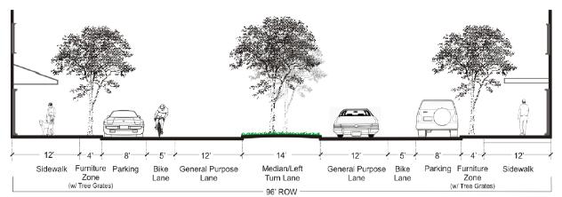
Street Cross Section E1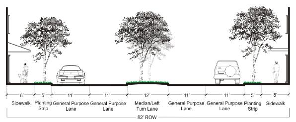
Street Cross Section F
1 Street Cross Section E is interim pending the results of a corridor study conducted in coordination with identification of a high-capacity/light rail alignment by the Sound Transit Board of Directors.
(Ord. 2493; Ord. 2385; Ord. 2383)
20C.45.40-080 Pedestrian Standards.
(1) General Requirement. Developments in Overlake districts shall provide an on-site pedestrian circulation system that at a minimum meets the standards of this section. In addition, the standards in RCDG 20C.45.40-070, Overlake Street Cross Sections, and the Overlake Master Plan shall apply as applicable.
(2) Connections.
(a) Connection to the Street. The system shall connect all major building entrances with the nearest public sidewalk by a walkway.
(b) Internal Connections. The system shall connect all buildings on the site, and provide connections to other areas of the site, such as parking areas, bicycle parking, recreational areas, plazas or common outdoor areas, and any pedestrian amenities.
(c) Connection to Neighboring Uses. The system shall connect to all adjacent properties. The connections shall run to the property line and connect to paths or sidewalks on neighboring properties or to the likely location of connections on those properties. Where no connections exist on a neighboring property and extending a connection would create a safety hazard or it is not possible to determine the likely location of future connections on that property, the Administrator may enter into a legally binding agreement with the owner of the property being developed to construct the connection to the neighboring use when the property on which the use is located develops or redevelops. This agreement shall run with the land and be recorded in King County’s real property records.
(3) Design.
(a) The circulation system shall be concrete, and be at least six feet wide. The Technical Committee may approve alternatives to concrete if site or design conditions warrant.
(b) Where the system crosses driveways, parking areas, and loading areas, the system shall be clearly identifiable, through the use of a different paving material or other equally effective method. Striping does not meet this requirement.
(c) Where the system is parallel and adjacent to an auto travel lane, the system shall be a raised path or be separated from the auto travel lane by a raised curb, bollards, landscaping or another physical barrier. If a raised path is used, the ends of the raised portions shall be equipped with curb ramps.
(d) Lighting. The on-site pedestrian circulation system shall be lighted to intensity where the system can be used at night by employees, residents, and customers. Lighting should be at a height appropriate to a pedestrian pathway system.
(4) Urban Pathway.
(a) As properties in the Overlake Village Design District and Overlake Design District are developed, corresponding portions of the urban pathway shown on the Overlake Village Subarea Map shall be installed or otherwise provided for by the property owner/developer. In order to provide flexibility, the actual alignment shall be determined through the Site Plan Entitlement process.
(b) The improvements shall include a 12-foot-wide concrete path with eight feet of landscaping on both sides as part of a 28-foot corridor, with pedestrian lighting and connections to existing or planned plazas or open spaces. The Technical Committee may approve alternatives to concrete if site or design conditions warrant. Where the pathway follows existing or planned streets or extends along retail storefronts, the corridor width may be reduced through the Site Plan Entitlement process.
(c) The landscaping shall include a combination of trees, shrubs and other plant materials to enhance visual interest and create a park-like quality along the pathway. The quantity and type of plant materials shall be approved by the Technical Committee and may vary along the pathway to provide compatibility with the adjoining land use. For example, the landscaping could include more shrubs and groundcover and fewer trees where visibility of retail storefronts is needed. (Ord. 2385; Ord. 2383)
20C.45.40-090 Ground Floor Uses.
(1) General Requirement. This section establishes requirements regarding ground floor uses located on streets within the Overlake Village Design District and Overlake Design District.
(2) Standards for 152nd Avenue NE.
(a) Proposed new buildings located along 152nd Avenue NE shall include pedestrian-oriented uses on the ground floor. Pedestrian-oriented uses include retail, restaurants, cultural or entertainment uses, hotel lobbies, travel agencies, personal service uses, parcel and mail services, copy centers, the customer service portion of financial institutions, or other businesses that are intended to be pedestrian attracting or pedestrian generating in nature as determined by the Code Administrator.
(b) Compliance Methods.
(i) A minimum of 50 percent of the linear sidewalk level facade shall be occupied by pedestrian-oriented uses as defined in subsection (2)(a) of this section, and should be continuous.
(ii) Up to 50 percent of the linear sidewalk level frontage may be designed to accommodate future conversion to the uses listed in subsection (2)(a) of this section. Any uses other than residential may be permitted in the interim until conversion of the space. The areas designed and constructed to accommodate future conversion shall meet the following standards in addition to other applicable design standards:
(A) Minimum of 14-foot distance from the finished floor to the finished ceiling.
(B) Minimum average depth of 25 feet measured from the wall abutting the street frontage to the rear wall of the retail use and a minimum width of 20 feet measured from the interior walls of the retail use.
(C) Inclusion of an entrance or entrances at the sidewalk level facade to accommodate either a single or multiple tenants or structural design so that entrances can be added when converted to the uses listed in subsection (2)(a) of this section.
(3) Other Streets in the Overlake Village Subarea. New buildings fronting on the streets listed below shall include commercial or other nonresidential uses on the ground floor. Offices and recreational areas associated with residential uses are permitted on the ground floor.
(a) 148th Avenue NE.
(b) Bel-Red Road.
(c) NE 24th Street.
(d) 156th Avenue NE.
(4) In locations where ground floor residential units are permitted, they shall be set back a minimum of 10 feet from the back of the required setback zone or all living areas with windows shall be elevated above the street grade at least three feet to provide for increased privacy. The Code Administrator may consider alternative design solutions that retain resident privacy while enhancing the pedestrian environment on the sidewalk. (Ord. 2385; Ord. 2383)
20C.45.40-100 Minimum Residential Floor Area.
(1) General Requirement. This section establishes requirements regarding minimum livable residential floor area as part of development in the Overlake Village Design District and Overlake Design District.
(2) Standard.
(a) Proposed new developments within the Overlake Village Mixed-Use, Emphasizing Residential Area and Overlake Design District shall include and construct residential uses as a minimum of 50 percent of the gross floor area of proposed uses.
(b) Proposed new developments within the Overlake Village Mixed-Use, Maintaining Regional Retail and Mixed-Use, Maintaining Commercial Areas shall include and construct residential uses as a minimum of 25 percent of the gross floor area of proposed uses. (Ord. 2385; Ord. 2383)
20C.45.40-110 Residential Usable Open Space.
(1) General Requirement. The minimum residential usable open space requirement establishes the minimum percentage of a development that must be set aside to provide usable open space for residents of new developments in Overlake districts. Every new development that includes residences shall provide usable open space in an amount equal to at least 6.25 percent of the gross residential floor area, defined as total living area and common spaces that provide access. Alternatives for configuration of the total amount of open space required for the development are provided below.
(a) Common Open Space. May be used to meet 100 percent of the required open space in the form of landscaped courtyards or decks, gardens with pathways, children’s play areas, or other multi-purpose recreational and/or green spaces, provided the following conditions are met:
(i) The space is accessible to all residents.
(ii) Required setback areas shall not count towards the open space requirement unless it is part of a space that meets the dimensional requirements.
(iii) The dimensions of the space shall be large enough to provide functional leisure or recreational activity as determined by the Technical Committee. For example, long narrow spaces (less than 20 feet wide) are not functional as usable common space.
(iv) The open space (particularly children’s play areas) shall be visible from dwelling units and positioned near pedestrian activity.
(v) The open space shall include landscaping, seating, lighting and other pedestrian amenities to make the area functional and enjoyable.
(vi) Individual entries shall be provided onto common open space from adjacent ground floor residential units. Small, semi-private open spaces for adjacent ground floor units that maintain visual access to the common area are strongly encouraged to enliven the space.
(vii) The open space shall be separated from ground floor windows, streets, service areas and parking lots with landscaping, low-level fencing, and/or other treatments as approved by the Technical Committee that enhance safety and privacy (both for common open space and dwelling units).
(viii) The space should be oriented to receive sunlight, facing east, west, or (preferably) south, when possible.
(ix) Native and/or drought-resistant plants should be used to reduce irrigation requirements and conserve water.
(x) Permeable surfaces, rain gardens, and other stormwater management features are encouraged.
(xi) Water features are encouraged.
(2) Individual Balconies or Patios and Indoor Recreational Space. May be used to meet up to 50 percent of the required open space. To qualify as open space, balconies or patios shall be at least 50 square feet, with no dimension less than five feet, to provide a space usable for human activity.
(3) Rooftop Decks. May be used to meet up to 50 percent of the required open space, provided the following conditions are met:
(a) The space is accessible (ADA) for all residents.
(b) The open space includes landscaping, seating, and other features as approved by the Technical Committee to encourage use and make the area functional and enjoyable.
(c) The space features hard surfacing appropriate to encourage resident use.
(d) The space incorporates features that provide for the safety of residents, such as enclosures and appropriate lighting levels.
(4) Combining Usable Open Space and Pedestrian Access. Parking areas, driveways and pedestrian access other than pedestrian access required by Washington State Rules and Regulations for Barrier-Free Design shall not be counted as usable open space, except if the total width of the common usable open space is 20 feet or wider, any pedestrian path or walkway traversing through the open space may be considered usable open space. (Ord. 2385; Ord. 2383)
20C.45.40-120 Administrative Design Flexibility.
(1) The purpose of this section is to promote creativity in site layout and design, and to allow flexibility in the application of standards for retail, commercial, office, mixed-use, and residential development within Overlake, and to achieve the creation of sites and uses that may benefit the public by the application of special design policies and standards not otherwise possible under conventional development regulations and standards. Departures from standards included in this section may be permitted as part of the Site Plan Entitlement process.
(2) Deviations from these standards may be allowed if an applicant demonstrates that the deviations from the standards would result in a development that:
(a) Better meets the intent of the goals and policies for the district in which the site is located;
(b) Is superior in design in terms of architecture, building materials, site design, landscaping and open space; and
(c) Provides benefit to the Overlake Neighborhood in terms of desired use, activity, and design.
(3) ADF – Flexibility of Design Standards in Overlake. Requirements of RCDG Title 20C, Land Use Regulations, that may be modified by application of this subsection are defined specifically as follows:
(a) Parking Lot Location. Requirements for the location of on-site parking lots may be modified within the development to provide for greater joint-use and quasi-public parking opportunities and uses which are highly desirable in the subject district.
(b) Street standards for townhouse subdivision developments.
(c) Other Site Requirements and Standards. All other site requirements and standards for Overlake districts except number of stories and FAR may be modified within the development to provide superiority in site design; i.e., greater amounts of privacy, maintenance of views, preservation of vegetation, greater environmental benefit, distinctive and high-quality design, improved pedestrian access, provision of usable open space, adequate light, air, and security. (Ord. 2385; Ord. 2383)
20C.45.40-130 Overlake Business and Advanced Technology Capacity Phasing.
(1) The purpose of this section is to allow for increases in nonresidential development capacity in the Overlake Business and Advanced Technology zone over time by linking increases in maximum permitted nonresidential floor area ratio to progress on mode-split goals, improvements to transportation facilities or services, increased residential development in Overlake, and the adequacy of parks, emergency services and other services needed for a daytime population.
(2) Increase to 0.47/0.55 FAR. The maximum permitted nonresidential floor area ratio in the Overlake Business and Advanced Technology zone shall be increased as follows when the Code Administrator determines a minimum of 10 points are achieved as defined in Table 1 of this section.
(a) Without use of TDRs: from 0.40 to 0.47.
(b) With use of TDRs: from 0.47 to 0.55.
(3) Increase to 0.55/0.62 FAR. The maximum permitted nonresidential floor area ratio in the Overlake Business and Advanced Technology zone shall be increased as follows when the Code Administrator determines a cumulative total of 20 points are achieved as defined in Table 1 of this section.
(a) Without use of TDRs: from 0.47 to 0.55.
(b) With use of TDRs: from 0.55 to 0.62.
|
Event |
Points |
|
Each increment of 250 residential dwellings permitted in Overlake |
3 |
|
Overlake Village Park (2.5 acres minimum): project fully funded |
1 |
|
Overlake Village Park (2.5 acres minimum): land acquired or dedicated |
1 |
|
Overlake Village Park (2.5 acres minimum): operational |
1 |
|
Overlake Village Regional Stormwater Facility 1: project fully funded |
1 |
|
Overlake Village Regional Stormwater Facility 1: land acquired or dedicated |
1 |
|
Overlake Village Regional Stormwater Facility 1: operational |
1 |
|
Overlake Village Regional Stormwater Facility 2: project fully funded |
1 |
|
Overlake Village Regional Stormwater Facility 2: land acquired or dedicated |
1 |
|
Overlake Village Regional Stormwater Facility 2: operational |
1 |
|
King County Metro RapidRide service operational in Overlake |
3 |
|
Sound Transit Bus Rapid Transit service operational in Overlake |
3 |
|
Other transit or shuttle connections between employment campuses in OBAT and retail and service locations in the Overlake Village subarea at 30-minute or better frequencies from 8:00 a.m. to 7:00 p.m. |
3 |
|
East Link Light Rail Segment D: preliminary design complete |
2 |
|
East Link Light Rail Segment D: construction contract awarded |
4 |
|
East Link Light Rail Segment D: operational |
5 |
|
East Link Light Rail Segment E: preliminary design complete |
1 |
|
East Link Light Rail Segment E: construction contract awarded |
3 |
|
East Link Light Rail Segment E: operational |
4 |
|
Overlake Access Project (slip ramp): preliminary design complete |
1 |
|
Overlake Access Project (slip ramp): construction contract awarded |
3 |
|
Overlake Access Project (slip ramp): operational |
4 |
|
148th Avenue NE Corridor Improvements Phase I: preliminary design complete |
1 |
|
148th Avenue NE Corridor Improvements Phase I: operational |
2 |
|
West Lake Sammamish Parkway Improvements: operational |
2 |
|
NE 40th Street Nonmotorized Bridge: operational |
2 |
|
SR 520 Trail Grade Separation at NE 40th and NE 51st Streets: operational |
2 |
|
Overlake Wayfinding Program: Tier 1 Directional Signs installed |
1 |
|
Overlake CTR-affected employers’ average nonsingle-occupancy-vehicle mode split of 45% |
5 |
|
Overlake CTR-affected employers’ average nonsingle-occupancy-vehicle mode split of 50% |
5 |
(Ord. 2493)