


4-3-110 URBAN SEPARATOR OVERLAY REGULATIONS:
A. PURPOSE:
The purpose of this Section is to implement the policies in the Land Use Element of the Comprehensive Plan related to urban separators. The intent is to provide physical and visual distinctions between Renton and adjacent communities, define Renton’s boundaries and create contiguous open space corridors within and between urban communities, which provide environmental, visual, recreational and wildlife benefits. Urban separators shall be permanent low-density lands that protect resources and environmentally sensitive areas. (Ord. 5132, 4-4-2005; Ord. 5759, 6-22-2015)
B. APPLICABILITY:
This Section shall apply to subdivisions and building permits on lands within designated urban separators as shown in the urban separators maps. (Ord. 5132, 4-4-2005)
C. URBAN SEPARATORS MAPS:
1. May Valley Urban Separator: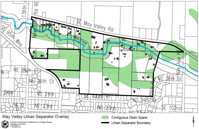
2. Talbot Urban Separator: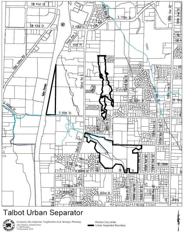
(Ord. 5132, 4-4-2005)
3. Soos Creek Urban Separator:
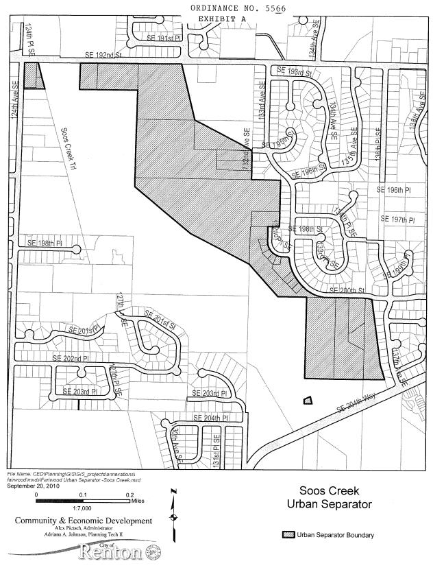
(Ord. 5566, 10-25-2010)
4. Lake Desire Urban Separator:
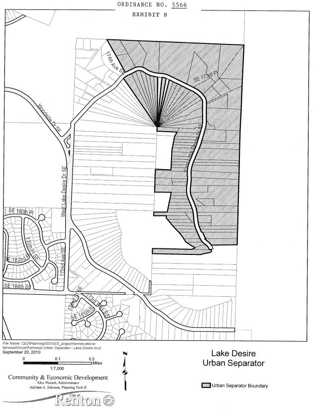
(Ord. 5566, 10-25-2010)
D. ADMINISTRATION:
1. Review Process: Applications subject to urban separator regulations shall be processed as a component of the governing land use process.
2. Authority: The Community and Economic Development Administrator shall have the authority to approve with conditions or deny proposals based on the provisions of the Urban Separator Overlay regulations when no other permit or approval requires Hearing Examiner review. (Ord. 5132, 4-4-2005; Ord. 5676, 12-3-2012)
E. URBAN SEPARATOR OVERLAY REGULATIONS:
1. Contiguous Open Space Corridor Established: A designated contiguous open space corridor is established as shown on the Urban Separators Overlay Map in subsection C of this Section.
2. Dedication of Open Space Required.
a. Approval of a plat, and/or building permit on an undeveloped legal lot:
i. May Valley Urban Separator Overlay: Approval of a plat, and/or building permit on an undeveloped legal lot in the May Valley Urban Separator Overlay shall require dedication of fifty percent (50%) of the gross land area of the parcel or parcels as a non-revocable open space tract retained by the property owner, or dedicated to a homeowners association or other suitable organization as determined by the Administrator.
ii. Talbot Urban Separator Overlay: Approval of a plat, and/or building permit on an undeveloped legal lot in the Talbot Urban Separator Overlay shall require dedication of fifty percent (50%) of the gross land area of that portion of the parcel or parcels located within the Urban Separator as a non-revocable open space tract retained by the property owner, or dedicated to a homeowners association or other suitable organization as determined by the Administrator. In order to satisfy the dedication requirement, some of the area to be dedicated may consist of land abutting the Urban Separator, as determined by the Community and Economic Development Administrator, on a case-by-case basis. Acreage in tracts may include critical areas and/or critical area buffers. At a minimum, open space shall be connected to another contiguous open space parcel by a fifty foot (50') corridor. (Ord. 5578, 11-15-2010; Ord. 5676, 12-3-2012)
b. Existing residences, existing accessory uses and structures, existing above ground utilities located in the tract at the time of designation and new small and medium utilities shall not count toward the fifty percent (50%) gross land area calculation for open space except for stormwater ponds designed with less than 3:1 engineered slopes and enhanced per techniques and landscape requirements set forth in the publication the “Integrated Pond” King County Land and Water Resources Division.
c. Approval of a building permit for an addition of three hundred (300) square feet for a primary use structure or five hundred (500) square feet for an accessory structure shall require recordation of a conservation easement, protective easement or tract and deed restriction on critical areas and critical area buffers located within the contiguous open space corridor pursuant to RMC 4-3-050E4, Native Growth Protection Areas.
d. Land dedicated as open space shall be located within the mapped contiguous open space corridor unless a modification is approved pursuant to subsection E6 of this Section.
3. Uses Allowed in Contiguous Open Space.
a. Passive recreation with no development of active recreation facilities except within a municipal park.
b. Soft surface pedestrian trails, provided the adjacent area is large enough to infiltrate runoff generated from the pathway consistent with the Surface Water Design Manual.
c. Animal husbandry (small, medium and large); provided, that fencing is subject to the conditions in subsection E3g of this Section.
d. Existing residences and accessory uses and structures.
e. Small and medium utilities and large underground utilities. (Ord. 5828, 12-12-2016)
f. Access Easements.
i. Utilities easements and emergency service access roads may be located within contiguous open space corridors for the limited purpose of providing service to parcels platted after March 2005, for which there is no practical alternative way to provide service. Utilities and emergency service easements shall be developed with permeable surface treatment.
ii. Private access easements for ingress and egress may be located within contiguous open space in the limited instance where there is no alternative access to a pre-existing legal lot, but shall not serve lots platted after March 2005.
g. Fencing or similar structures and/or hedges or similar landscape features on the property or easement boundary of properties abutting and within the contiguous open space corridor shall not create a solid barrier. Where required to protect wetlands pursuant to RMC 4-3-050E4e, fencing shall be the minimum necessary.
4. Uses in Portions of the Urban Separator Outside the Established Contiguous Open Space Corridor.
a. Uses shall be consistent with RMC 4-2-060 and 4-2-070B. Residential-1 Zone, one (1) dwelling unit per net acre.
b. Development shall be clustered outside the contiguous open space corridor mapped in subsection C of this Section.
5. Standards Within Entire Urban Separator.
a. Forest/vegetation clearing shall be limited to a maximum of thirty-five percent (35%) of the gross acreage of the site except:
i. The percentage of forest/vegetation coverage may be increased to qualify for the density bonus allowed in RMC 4-2-110I. (Ord. 5960, 12-9-2019; Ord. 6160, 6-16-2025)
ii. Modification of the percentage of forest/vegetation retention may be approved if determined necessary to meet the surface water retention/detention standards of subsection E5d of this Section.
iii. Forest/vegetation clearing greater than thirty-five percent (35%) of individual building sites may be approved to allow grading for a home site; provided, that:
(a) A landscape plan is provided for each building site showing compensating replanting of species with the same or better water retention and erosion control functions;
(b) Five percent (5%) additional replacement landscaping per site is provided;
(c) Plant caliper is sufficient to achieve needed water retention and erosion control functions;
(d) Individual trees or stands of trees are retained when feasible. Feasibility is defined as locations and tree health sufficient to ensure continued viability of the tree and safety of structures within the developed portion of the lot; and
(e) The landscape plan provides massing of plant material to create either a connection to required open space or is of sufficient size to create functional wildlife habitat.
b. If the existing cleared area of a site, as of March 21, 2005, is greater than thirty five percent (35%), approval of a plat shall require replanting of forest/vegetative cover.
c. Forest/vegetation cover may include a combination of Northwest native vegetation including conifer, deciduous trees and shrubs sufficient to provide water retention and erosion control. If existing vegetation is found to be insufficient to meet forest/vegetation coverage standards, additional plantings shall be required.
d. Stormwater management shall comply with the Surface Water Design Manual. (Ord. 5526, 2-1-2010)
e. Private access easements and improvements shall be established at the minimum standard needed to meet public safety requirements.
f. Landscape plans required in RMC 4-4-070 shall include retention/replanting plans as applicable, consistent with standards and plant lists in King County Department of Natural Resources and Parks Water and Land Resources Division Publication “Going Native.” (Ord. 5676, 12-3-2012)
6. Modification of Mapped Contiguous Open Space: Modification of the open space configuration may be approved where:
a. Site specific data confirms that the adopted contiguous open space corridor map includes more than the required gross area for any parcel; or
b. The applicant can demonstrate a configuration of contiguous open space that provides better or equal provision of the open space requirement. Modifications to the contiguous open space corridor shall be remapped during the City’s annual RMC Title 4 review process. (Ord. 5132, 4-4-2005; Ord. 5676, 12-3-2012)