


CHAPTER 5
CRITICAL AREAS CODE
SECTION:
10-5-4: Critical Areas Code; Administration
10-5-11: Mitigation Plan Requirements
10-5-12: Independent Review Of Critical Area Report
10-5-13: Substantive Requirements
10-5-15: Enforcement And Inspections
10-5-16: Record Per WAC 365-195-915 And 365-195-920
10-5-17: Legal Nonconforming Uses
10-5-1 FINDINGS:
The city finds that critical areas’ biological and physical functions benefit the city by protecting water quality, providing fish and wildlife habitat, supporting the food chain, storing and conveying floodwater, recharging ground water, controlling erosion, and providing aesthetic values and recreation. (Ord. 695, 11-22-2004)
10-5-2 PURPOSE:
The purpose of this chapter is to:
A. Protect the functions and values of ecologically sensitive areas while allowing for reasonable use of private property, through the application of the best available science;
B. Implement the growth management act1 and the natural environment goals of the comprehensive plan; and
C. Protect the public from injury and loss due to slope failures, erosion, seismic events, volcanic eruptions, or flooding. (Ord. 695, 11-22-2004)
10-5-3 DEFINITIONS:
Unless context clearly indicates otherwise, the following definitions shall apply throughout this chapter:
|
ALTER: |
To change a critical area or its buffer, including grading, filling, dredging, clearing, construction, compaction, excavation, and pollution. |
|
ANADROMOUS: |
Refers to fish that spawn and rear in freshwater and mature in saltwater. |
|
APPLICANT: |
A person who applies for a development permit from the city. |
|
AQUIFER: |
A geological formation capable of yielding water to a well or spring. |
|
BEST MANAGEMENT PRACTICES: |
Actions known to protect soil, water quality, vegetation, and critical areas. |
|
BUFFER: |
An area contiguous to and required for protection of a critical area. |
|
CHANNEL MIGRATION ZONE: |
The lateral extent of likely movement of a stream or river during the next one hundred (100) years as evidenced by movement over the past one hundred (100) years. |
|
CONSERVATION EASEMENT: |
A legal agreement that the property owner enters into to restrict uses of the land in a manner that conserves natural functions. |
|
CRITICAL AQUIFER RECHARGE AREA: |
An area with a critical recharging effect on aquifers used for potable water, as discussed in WAC 365-190-080(2). Within such areas, pollutants seeping into the ground are likely to contaminate the water supply. |
|
CRITICAL AREA: |
Those areas listed in section 10-5-6. |
|
DEVELOPMENT: |
Any land use or action that alters a critical area or its buffer, including city approvals that establish patterns of use such as subdivisions, short subdivisions, rezones, and conditional use permits. |
|
FISH HABITAT: |
Habitat used by fish at any life stage at any time of the year. |
|
FLOODPLAIN: |
The land area subject to inundation by a one hundred (100) year flood. |
|
FLOODWAY: |
The watercourse channel and adjacent land area that must be reserved in order to discharge the one hundred (100) year flood without cumulatively increasing the water elevation more that one foot (1'). |
|
FUNCTIONS AND VALUES: |
The benefits conferred by critical areas, including water quality protection, fish and wildlife habitat, food chain support, flood storage and conveyance, ground water recharge, erosion control, and protection from hazards. "Function" means the benefit, "value" means the magnitude of the benefit. |
|
HAZARDOUS SUBSTANCE: |
A liquid, solid, or gas that exhibits any of the properties described in WAC 173-303-090 or 173-303-100. |
|
HISTORIC: |
Existing before the area was altered by human activity. |
|
IMPACT: |
To adversely affect a natural system or increase the hazard which a natural system poses to human life and property. |
|
IMPERVIOUS: |
Refers to a hard surface area that retards the entry of water into the soil. |
|
LOWEST FLOOR: |
Excludes unfinished enclosures usable only for parking, building access, or storage. |
|
MONITORING: |
Assessing the performance of mitigation measures by collection and analysis of data on changes in natural systems. |
|
ONE HUNDRED (100) YEAR FLOOD: |
A flood having a one percent (1%) chance of being equaled or exceeded in any given year. |
|
ORDINARY HIGH WATER MARK: |
That mark on the bed or bank below which inundation is so common in ordinary years that the soil and/or vegetation are distinct from that of the abutting upland. |
|
PERSON: |
Any person, organization, or other group. |
|
PRIMARY ASSOCIATION: |
A relationship between a species and a habitat area whereby the species regularly uses or otherwise needs the habitat area to thrive. |
|
RIPARIAN HABITAT: |
Streamside areas that influence the aquatic ecosystem by providing shade, debris, or insects and provide habitat for riparian wildlife. |
|
SPECIES: |
A group of animals commonly classified by the scientific community as a species or subspecies. |
|
SUBSTANTIAL IMPROVEMENT: |
Any repair, reconstruction, or improvement of a structure, the cost of which exceeds fifty percent (50%) of the structure’s market value before the improvement, or, if the structure was damaged, before the damage occurred. |
|
WATERCOURSE: |
Flowing waters of the state, perennial or intermittent, excluding artificial waterways such as ditches or canals not created by human alteration of a natural watercourse. |
|
WETLAND: |
Wetlands are those areas, designated in accordance with the approved federal wetland delineation manual and applicable regional supplements, that are inundated or saturated by surface water or ground water at a frequency and duration sufficient to support, and that under normal circumstances do support, a prevalence of vegetation typically adapted for life in saturated soil conditions. Wetlands generally include swamps, marshes, bogs, and similar areas. Wetlands do not include those artificial wetlands intentionally created from nonwetland sites, including, but not limited to, irrigation and drainage ditches, grass-lined swales, canals, detention facilities, wastewater treatment facilities, farm ponds, and landscape amenities, or those wetlands created after July 1, 1990, that were unintentionally created as a result of the construction of a road, street, or highway. Wetlands may include those artificial wetlands intentionally created from nonwetland areas created to mitigate conversion of wetlands. |
|
WETLAND MITIGATION BANK: |
A site where wetlands are restored, created, or enhanced to mitigate, in advance, authorized impacts to similar resources. |
(Ord. 695, 11-22-2004; Ord. 938, 5-23-2016)
10-5-4 CRITICAL AREAS CODE; ADMINISTRATION:
This chapter, including articles A through E, shall collectively be known as the CRITICAL AREAS CODE. This chapter shall establish the general framework for articles A through E of this chapter. The city planner shall administer and interpret this chapter; provided, however, that the floodplain administrator shall review all applications under this section to determine the applicability of title 13, "Flood Control", of this code, and no application shall be approved without the floodplain administrator’s approval pursuant to title 13 of this code, if the title applies. (Ord. 857, 9-12-2011)
10-5-5 FEES:
The city shall establish fees by which the city shall recover its cost of reviewing development proposals, including the cost of engineering review, planning review, inspections, and administration. The applicant shall be responsible for all required reports, assessments, studies, and plans. (Ord. 695, 11-22-2004)
10-5-6 APPLICABILITY:
Unless exempted in section 10-5-7 of this chapter, this chapter shall apply to all "developments" (see definition in section 10-5-3 of this chapter) within one or more of the following critical areas or their associated buffers or building setback areas, regardless of whether the site has been previously identified as a critical area, provided however that whenever a provision of this critical areas code is inconsistent with or conflicts with a provision of title 13, "Flood Control", of this code, title 13 controls. Any dispute over inconsistent or conflicting provisions between the critical areas code and title 13 of this code shall be resolved by the floodplain administrator in consultation with legal counsel. The critical areas are:
A. Wetlands as designated in article A of this chapter;
B. Critical aquifer recharge areas as designated in article B of this chapter;
C. Floodplains as designated in article C of this chapter;
D. Geologically hazardous areas as designated in article D of this chapter; and
E. Fish and wildlife habitat conservation areas as designated in article E of this chapter. (Ord. 857, 9-12-2011)
10-5-7 EXEMPTIONS:
The following shall be exempt from this chapter unless otherwise required by title 13, "Flood Control":
A. Immediate Action: Emergency actions immediately necessary to prevent injury or property damage, provided the action minimizes impact to critical areas and buffers. The person undertaking the action shall notify the city planner within one (1) day following commencement of the emergency action. The city planner shall determine if the action was allowable under this subsection and commence enforcement if not. Within one (1) year of the date of the emergency, the person undertaking the action shall fully mitigate any resulting impacts to the critical area and buffers in accordance with an approved critical area report and mitigation plan.
B. Maintenance Or Repair Of Existing Structures, Roads: Normal operation, maintenance, or repair of existing structures, utilities, roads, levees, drainage systems, or similar improvements, including vegetation management, if the action does not alter or increase the impact to or encroach upon the critical area or buffer, and if the action accords with best management practices and maintenance, and does not impact an endangered or threatened species.
C. Passive Outdoor Activities: Passive outdoor activities such as recreation, education, and scientific research that do not degrade the critical area.
D. Forest Practices: Forest practices in accordance with chapter 76.09 RCW and WAC title 222, other than forest practice conversions.
E. Modification Of Existing Legal Structures: Structural modifications of, additions to, or replacements of existing legal structures without altering or increasing the impact to the critical area; provided, that the city’s regulations regarding legal nonconforming uses are complied with. This includes most tenant improvements.
F. Improved Public Rights-Of-Way: The following work within improved public rights-of-way or private street easements: construction, replacement, or modification of streets, utilities, lines, mains, equipment, or appurtenances, excluding electrical substations; provided, that actions that alter a wetland or watercourse, such as culverts or bridges, or result in the transport of sediment or increased stormwater shall be subject to the following requirements wherever possible:
1. Critical area and/or buffer widths shall be increased equal to the width of the right-of-way improvement, including disturbed areas; and
2. Native vegetation shall be retained and replanted along the right-of-way improvement.
G. Minor Utility Projects: Minor utility projects such as placement of a utility pole, street sign, anchor, or vault, which do not significantly impact critical areas function or values, if constructed using best management practices.
H. Noxious Plants: Removal with hand labor and light equipment of invasive or noxious plants, as designated by the city planner, including:
1. English ivy (Hedera helix);
2. Himalayan blackberry (Rubus armeniacus, R. procerus); and
3. Evergreen blackberry (Rubus laciniatus).
I. Trees: Thinning or removal of trees which a qualified arborist, landscape architect, or forester has documented as posing a threat to public safety and which do not provide critical habitat such as eagle perches; provided, that removed trees and thinnings are left on site, and for each tree removed, two (2) replacement trees shall be planted in the same or nearly same location within one (1) year in accordance with a plan approved by the city planner. The replacement trees shall be of species native and indigenous to the site. Deciduous trees shall be at least one inch (1") in diameter at breast height. Evergreen trees shall be at least six feet (6') in height measured from the top of the root ball.
J. Insects: Measures to control fire or halt the spread of disease or damaging insects consistent with the State Forest Practices Act2; provided, that the removed vegetation shall be replaced with the same or similar native species within one (1) year in accordance with an approved plan.
K. Herbicides, Pesticides, Fertilizers: Application of herbicides, pesticides, or fertilizers; if necessary; provided, that their use shall conform to Department of Fish and Wildlife management recommendations and the regulations of the Department of Agriculture and the U.S. Environmental Protection Agency.
L. Surveys: Minor clearing or digging necessary for surveys, soil logs, percolation tests, and similar activities, provided critical area impacts are minimized and disturbed areas are immediately restored.
M. Navigational Aids: Navigational aids and boundary markers.
N. Critical Area Review: Proposed developments that have undergone critical area review at a previous stage of permit review, provided the earlier permit has not expired.
O. Wild Crops: Harvesting of wild crops without injuring their natural reproduction, tilling the soil, planting crops, applying chemicals, or altering the critical area.
P. Conservation Measures: Conservation measures of soil, water, vegetation, fish, and other wildlife that do not adversely impact ecosystems.
Q. Environmental Impact Remediation: Required environmental impact remediation.
R. Agricultural Activities: Existing and ongoing agricultural activities where the land has not lain idle so long that modifications to the hydrological regime are necessary to resume operations.
S. All isolated Category III and IV wetlands less than one thousand (1,000) square feet that:
1. Are not associated with riparian areas or buffers;
2. Are not part of a wetland mosaic; and
3. Do not contain habitat identified as essential for local populations of priority species identified by the Washington Department of Fish and Wildlife or species of local importance identified in this chapter. (Ord. 857, 9-12-2011; Ord. 938, 5-23-2016)
10-5-8 REVIEW PROCESS:
The city planner’s general sequence for administering this chapter shall be per table (1) of this section, which shows questions the city planner shall answer, and actions he or she shall take depending on the answer; provided, however, that the floodplain administrator shall review each proposed development to determine whether title 13, "Flood Control", of this code applies. Whenever the floodplain administrator finds that title 13 of this code is applicable, the floodplain administrator, in conjunction with the city planner, shall also follow table (2), "Permit Processing Flow Chart", of this section.
|
Step 1: |
Is the development proposal in a critical area or its buffer? |
|
|
|
The city planner shall check maps, review the environmental checklist, visit the site, and require scientific determinations as necessary to make this determination. |
|
|
|
Yes |
No |
|
|
Go to step 2. |
Go to step 4. |
|
Step 2: |
Is the development proposal exempt per section 10-5-7 of this chapter? |
|
|
|
Yes |
No |
|
|
Go to step 4. |
Require a critical area report. Do not issue determination of completeness until critical area report is received. Reference critical area report in any public notice. |
|
Step 3: |
Does the proposal, with conditions of approval as necessary, conform to section 10-5-13, "Substantive Requirements", of this chapter? |
|
|
|
Yes |
No |
|
|
Go to step 4. |
Go to step 4. |
|
Step 4: |
Document the review process in a manner appropriate to, and filed with, the permit(s) required for the proposed development, and act on the permit application in accordance with the findings. |
|
(2) PERMIT PROCESSING FLOW CHART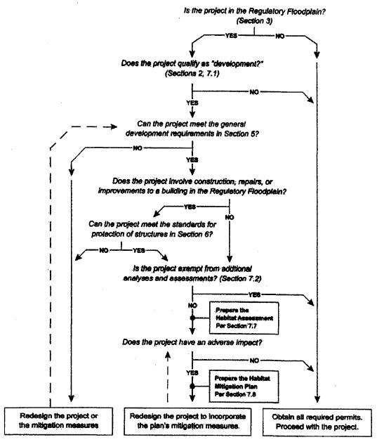
(Ord. 857, 9-12-2011)
10-5-9 CRITICAL AREA REPORTS:
Unless waived by the city planner, critical area reports shall be prepared for nonexempt proposed developments located within critical areas or their buffers. Said critical area reports shall:
A. Be prepared by qualified professionals as defined in Washington administrative code 365-195-905(4). The following list shows the type of critical area report and the related professional discipline:
1. Wetlands: wetland biologist.
2. Critical aquifer recharge areas: hydrogeologist, geologist, or engineer.
3. Floodplains: hydrologist or engineer.
4. Geologically hazardous areas: engineer or geologist.
5. Fish and wildlife habitats: biologist.
B. Incorporate best available science.
C. Cover a study area large enough to understand relationships with important off site factors and identify any off site critical area so near that its required buffer covers part of the project site.
D. Contain the following unless waived by the city planner:
1. Name and contact information of the applicant, description of the proposed development, and identification of required permits.
2. Site plan drawn to scale showing critical areas, buffers, existing structures, and proposed structures, clearing, grading, and stormwater management.
3. Characterization of critical areas and buffers.
4. Assessment of the probable impact to critical areas.
5. Analysis of site development alternatives.
6. Description of efforts to avoid, minimize, and mitigate impacts to critical areas pursuant to subsection 10-5-13E, "Sequencing", of this chapter.
7. Mitigation plans as needed, in accordance with section 10-5-11 of this chapter.
8. Evaluation of compliance with this chapter’s substantive requirements applicable to the proposed development.
9. Financial guarantees to ensure compliance, such as a performance bond or deposit, if necessary.
10. Additional information as required in this chapter corresponding to the type of critical area.
11. Documentation of who prepared the report and when, with field work and data sheets.
12. Statement specifying the accuracy of the report and assumptions relied upon.
13. Additional information as required by the city planner. (Ord. 695, 11-22-2004)
10-5-10 PREVIOUS STUDIES:
Critical area reports may rely upon, without duplication of effort, valid previous studies prepared for the site, taking into account any change in the site, the proposed development, or the surrounding area. (Ord. 695, 11-22-2004)
10-5-11 MITIGATION PLAN REQUIREMENTS:
If the city allows conformance with this chapter’s substantive requirements to be achieved by mitigation, the critical area report shall include a mitigation plan consisting of:
A. An analysis of the anticipated impacts.
B. A strategy for mitigating the impacts, including site selection factors.
C. An analysis of the anticipated functions and values that will result from the mitigation, including an assessment of risks.
D. A review of the best available science relative to the proposed mitigation.
E. Specific standards for evaluating whether the mitigation is successful.
F. Detailed construction plans, including:
1. Construction timing;
2. Grading and excavation details;
3. Erosion and sediment control features;
4. Planting plan; and
5. Measures to protect plants until established.
G. A program for monitoring the mitigation over at least five (5) years.
H. Potential corrective measures should the monitoring indicate standards are not being met.
I. Wetland mitigation plans shall meet the requirements established in section 10-5A-4D. (Ord. 695, 11-22-2004; Ord. 938, 5-23-2016)
10-5-12 INDEPENDENT REVIEW OF CRITICAL AREA REPORT:
The city planner may have the critical area report evaluated by an independent qualified professional and/or request consultation from an agency with expertise. If the report and evaluations disagree, the city planner shall determine which to utilize. (Ord. 695, 11-22-2004)
10-5-13 SUBSTANTIVE REQUIREMENTS:
A. Treatment: All treatment of critical areas shall be in accordance with best available science as defined in WAC 365-195-900 through 365-195-925, which is hereby adopted by reference, along with the Washington State Department of Community Development’s "Citations Of Recommended Sources Of Best Available Science For Designating And Protecting Critical Areas."
B. Activities Allowed: Critical areas and their buffers shall be left undisturbed except the following may be permitted if best management practices are used:
1. Authorized functional restoration;
2. In buffers: utility poles and utility lines which do not require excavation;
3. In the outer twenty-five percent (25%) of buffers: permeable surfaced walkways, trails, and minimal wildlife viewing structures;
4. Developments for which mitigation is allowed per subsection E of this section; and
5. Other uses specifically authorized by this chapter.
C. Loss Of Functions Or Values: No development shall occur which results in a net loss of the functions or values of any critical area except reasonable use variances per section 10-5-14B. The predevelopment and postdevelopment functional comparison shall be on a per function basis unless otherwise authorized by section 10-5A-6I.
D. Unreasonable Hazard: No development shall occur in critical areas and their buffers which results in an unreasonable hazard to the public health and safety.
E. Sequencing: These substantive requirements shall be met via one (1) or more of the following methods, listed in preferential sequence (commonly known as "sequencing"). Mitigation shall be required in the following order of preference:
1. Avoid the impact altogether by not taking a certain action or parts of an action.
2. Minimize impacts by limiting the degree or magnitude of the action and its implementation, by using appropriate technology, or by taking affirmative steps to avoid or reduce impacts.
3. Rectify the impact by repairing, rehabilitating, or restoring the affected environment.
4. Reduce or eliminate the impact over time by preservation and maintenance operations.
5. Compensate for the impact by replacing, enhancing, or providing substitute resources or environments.
6. Monitor the impact and take appropriate corrective measures.
F. Permit Approval Requirements: As a condition of any permit approval, the city may require that:
1. The outer edge of the critical area or buffer be marked, signed, or fenced to protect the resource. Such protection may be temporary, during construction, or permanent such as to protect the resource from livestock or people. The city planner shall specify the design and sign message, if applicable, of such markers, signs, and fencing.
2. The applicant file a notice with the county records and elections division stating the presence of the critical area or buffer and the application of this chapter to the property, to inform subsequent purchasers of the property.
3. The critical area and/or buffer be placed in a critical area tract or conservation easement, the purpose of which is to set aside and protect the critical area. The critical area tract or conservation easement shall be:
a. Held by the city, a homeowner’s association, a land trust or similar conservation organization, or by each lot owner within the development in an undivided interest;
b. Recorded on all documents of title of record for the affected parcels;
c. Noted on the face of any plat or recorded drawing; and
d. Delineated on the ground with permanent markers and/or signs in accordance with local survey standards.
G. Averaging Of Buffer Widths: The city may allow averaging of buffer widths if a qualified professional demonstrates that:
1. Functions and values are not adversely affected;
2. The total buffer area is not reduced; and
3. At no location is the buffer width reduced more than twenty-five percent (25%).
H. Building Setbacks: Unless otherwise provided, buildings and other structures shall be set back a distance of ten feet (10') from the edges of all critical areas and critical area buffers. The same protrusions into this setback area shall be allowed as the zoning code allows into property line setback areas.
I. Subdivisions And Short Plats: Lots created through subdivisions or short plats may contain critical areas and buffers, provided they contain adequate buildable area to build upon. Subdivision and short plats shall show, on their face, any applicable critical area limitations.
J. Conflicts, More Protection Required: When any existing regulation, easement, covenant, or deed restriction conflicts with this chapter, that which provides more protection to the critical areas shall apply.
K. More Restrictive Requirements Apply: When critical areas of two (2) or more types coincide, the more restrictive buffer and requirements shall apply.
L. Allowable Residential Units Per Acre: Subject to approval through the planned residential development process, or approval by the city planner, depending on who is the applicable decision maker, in calculating allowable residential units per acre, up to one hundred percent (100%) of the acreage of critical areas and buffers may be counted and this density transferred to buildable portions of the site.
M. Requirements Peculiar To Type Of Critical Area: The substantive requirements peculiar to the type of critical area shall also be complied with. See articles A through E of this chapter. (Ord. 695, 11-22-2004; Ord. 938, 5-23-2016)
10-5-14 VARIANCES:
The city may grant variances from this chapter’s substantive regulations in accordance with the variance process in the city zoning ordinance if the criteria in subsection A or B of this section are met.
A. The variance conforms with the variance criteria stated in the city zoning ordinance, plus the variance:
1. Conforms with the purpose of this chapter;
2. Does not impact anadromous fish habitat; and
3. Is justifiable in light of the best available science.
B. Reasonable use (conformance with the city zoning ordinance variance criteria not required).
1. The application of this chapter would otherwise deny all reasonable economic use of the property;
2. The city does not offer to compensate the owner for the denial of reasonable economic use;
3. No other reasonable economic use of the property or development design has less impact on the critical area;
4. The proposal does not pose an unreasonable threat to the public health, safety, or welfare;
5. The proposal conforms with other applicable regulations;
6. Impacts to critical areas are mitigated; and
7. The application is sufficiently documented (for example, critical area report, mitigation plan, permit applications, and environmental documents) to make a determination regarding these criteria. (Ord. 695, 11-22-2004)
10-5-15 ENFORCEMENT AND INSPECTIONS:
A. Violations; Enforcement: Violations of this chapter shall be equivalent to violations of the city zoning ordinance, including penalties therefor. The city clerk-treasurer shall enforce this chapter following the enforcement process in the city zoning ordinance. The city clerk-treasurer may require a restoration plan prepared by a qualified professional. Historic functions and values, soil configurations, and native vegetation shall be used as a guide for restoration. Flood and geological hazards shall be reduced to the predevelopment level.
B. Access For Inspections: Reasonable access to the development shall be provided to agents of the city for critical area inspections, monitoring, restoration, or emergency action. (Ord. 695, 11-22-2004)
10-5-16 RECORD PER WAC 365-195-915 AND 365-195-920:
A. Implement Comprehensive Plan: This chapter is designed to implement the city comprehensive plan’s natural environment element policies regarding protection functions and values of critical areas.
B. Based On Best Available Science: This chapter is based on best available science. See section 10-5-13A. This chapter largely derives from the "Example Code Provisions For Designating And Protecting Critical Areas" prepared by the Washington Department of Community, Trade, and Economic Development, which in turn is based on documented best available science. This chapter is also based on "Guidance Document For The Establishment Of Critical Aquifer Recharge Areas Ordinances", and "Wetlands and CAO Updates – Guidance for Small Cities," each published by the Washington Department of Ecology.
C. Preserve Fisheries: The city took special consideration to preserve or enhance anadromous fisheries, as evidenced in sections 10-5-14A, 10-5E-3E, and 10-5E-5H.
D. Economic, Political And Legal Factors: In addition to scientific information, economic, political, and legal factors were also considered in determining certain substantive requirements. Where this chapter’s buffer widths differ from those in the "Example Code Provisions For Designating And Protecting Critical Areas," the purpose is to develop the economy, protect property rights, and implement the growth management act requirement that growth be accommodated in urban growth areas. The city identifies no substantial risk to critical areas in enacting these alternative substantive requirements. (Ord. 695, 11-22-2004; Ord. 938, 5-23-2016)
10-5-17 LEGAL NONCONFORMING USES:
The city zoning ordinance regulations pertaining to continuation and discontinuation of legal nonconforming (preexisting) uses shall apply equally to this chapter. (Ord. 695, 11-22-2004)
RCW 36.70A.010 et seq.
RCW ch. 76.09.