


Chapter 18.05
Shoreline Master Program
Sections:
Article I. Introduction
18.05.010 History and Requirements of the Shoreline Management Act
18.05.020 Master Program Development and Public Participation
18.05.030 Purposes of the Shoreline Master Program
18.05.040 Legislative Findings and Washington Shoreline Management Policies
18.05.050 Shoreline Master Program Basics
18.05.060 Organization of This Shoreline Master Program
18.05.070 Relationship of This Shoreline Master Program to Other Plans
Article II. Definitions and Acronyms
Article III. Goals of the Shoreline Management Program
18.05.120 Economic Development Element
18.05.130 Public Access Element
18.05.140 Recreational Element
18.05.160 Conservation Element
18.05.170 Shoreline Use Element
18.05.180 Historic, Cultural, Scientific and Educational Element
Article IV. General Shoreline Provisions
18.05.200 Archaeological and Historic Resources
18.05.210 Environmental Impacts
18.05.240 Vegetation Conservation (Clearing and Grading)
18.05.250 Water Quality, Stormwater, and Non-Point Pollution
Article V. Shoreline Environments
18.05.260 Introduction to Shoreline Environment Designations
18.05.270 Need for Consistency
18.05.280 City of SeaTac Shoreline Environment Designations
18.05.290 High-Intensity Environment
18.05.300 Medium-Intensity Environment
18.05.310 Shoreline Residential Environment
18.05.320 Urban Conservancy Environment
18.05.340 Flexible Shoreline Setback Regulations
18.05.350 Shoreline Environment Designation Map
Article VI. Shoreline Use Provisions
18.05.370 Shoreline Use Standards
18.05.380 Specific Shoreline Use Regulations
Article VII. Shoreline Modification Provisions
18.05.400 Table of Shoreline Modification Activities
18.05.410 Shoreline Stabilization
18.05.430 Overwater Structures – Piers, Docks, Floats and Buoys
Article VIII. Administration
18.05.450 Program Administrator
18.05.470 Shoreline Permits and Exemptions
18.05.480 Nonconforming Use and Development Standards
18.05.490 Appeal to the State Shorelines Hearings Board
18.05.500 Enforcement and Penalties
18.05.510 Master Program Review
18.05.520 Amendments to Master Program
18.05.540 Conflict of Provisions
Article I. Introduction
18.05.010 History and Requirements of the Shoreline Management Act
A. Washington’s Shoreline Management Act (Act) was adopted by the public in a 1972 referendum “to prevent the inherent harm in an uncoordinated and piecemeal development of the state’s shorelines.” The Act has three (3) broad policies:
1. Encourage water-dependent uses: “uses shall be preferred which are consistent with control of pollution and prevention of damage to the natural environment, or are unique to or dependent upon use of the state’s shorelines...”
2. Protect shoreline natural resources, including “...the land and its vegetation and wildlife, and the water of the state and their aquatic life...”
3. Promote public access: “the public’s opportunity to enjoy the physical and aesthetic qualities of natural shorelines of the state shall be preserved to the greatest extent feasible consistent with the overall best interest of the state and the people generally.”
B. This Act recognizes that “shorelines are among the most valuable and fragile” of the State’s resources. The Act, and the City of SeaTac, recognize and protect private property rights along the shoreline, while aiming to preserve the quality of this unique resource for all State residents.
C. The primary purpose of the Act is to provide for the management and protection of the State’s shoreline resources by planning for reasonable and appropriate uses. In order to protect the public interest in preserving these shorelines, the Act establishes a coordinated planning program between the State and local jurisdictions to use in addressing the types and effects of development occurring along the State’s shorelines. By law, the City is responsible for the following:
1. Development of an inventory of the natural characteristics and land use patterns along shorelines covered by the Act.
2. Preparation of a “master program” to determine the future of the shorelines.
3. Development of a permit system to further the goals and policies of both the Act and the local master plan.
4. Development of a restoration plan that includes goals, policies and actions for restoration of impaired shoreline ecological functions. (Ord. 19-1015 § 2 (Exh. A § 1.1))
18.05.020 Master Program Development and Public Participation
The City of SeaTac (City) obtained a grant from the Washington Department of Ecology (Ecology) in 2007 to conduct a comprehensive Shoreline Master Program (SMP) update. The first step of the update process was to inventory the City’s shorelines as defined by the State’s Shoreline Management Act (SMA) (Chapter 90.58 RCW). Angle Lake is the only SMA shoreline in the City of SeaTac. The inventory describes existing biological and physical conditions. These conditions were then analyzed and characterized to create a baseline from which future development actions in the shoreline will be measured.
Environmental designations were identified for the different shoreline reaches and goals, policies, and regulations for each were developed.
The Guidelines require that the City demonstrate that its updated SMP yields “no net loss” in shoreline ecological functions relative to the baseline due to its implementation. Ideally, the SMP in combination with other City and regional efforts will ultimately produce a net improvement in shoreline ecological functions.
The City obtained a second grant from Ecology in 2018 to complete a periodic SMP update. Washington State law requires jurisdictions to review and update their SMPs every eight (8) years in accordance with the Shoreline Management Act (SMA) and its current guidelines and legislative rules to attain State approval. The periodic update to this SMP focused on reviewing relevant legislative updates since the comprehensive update and incorporating any applicable amendments and ensuring consistency with the City’s 2017 Comprehensive Plan Update and other City regulations. (Ord. 19-1015 § 2 (Exh. A § 1.2))
18.05.030 Purposes of the Shoreline Master Program
The purposes of this Master Program are:
A. To carry out the responsibilities imposed on the City of SeaTac by the Washington State Shoreline Management Act (Chapter 90.58 RCW).
B. To promote the public health, safety, and general welfare, by providing a guide and regulation for the future development of the shoreline resources of the City of SeaTac.
C. To further, by adoption, the policies of Chapter 90.58 RCW, and the goals of this Master Program, both of which hereafter follow.
D. To comply with the Shoreline Master Program Guidelines (Chapter 173-26 WAC), including a particular focus on including regulations and mitigation standards to ensure that development under the Shoreline Master Program will not cause a net loss of ecological functions. (Ord. 19-1015 § 2 (Exh. A § 1.3))
18.05.040 Legislative Findings and Washington Shoreline Management Policies
The Washington State Legislature finds the shorelines of the State are among the most valuable and fragile of its natural resources and there is great concern throughout the State relating to their utilization, protection, restoration, and preservation. In addition, it finds that ever increasing pressures of additional uses are being placed on the shorelines, necessitating increased coordination in the management and development of the shorelines of the State. The Legislature further finds that much of the shorelines of the State and uplands adjacent thereto are in private ownership and that unrestricted construction on the privately owned or publicly owned shorelines of the State is not in the best public interest; therefore, coordinated planning is necessary in order to protect the public interest associated with the shorelines of the State while, at the same time, recognizing and protecting private property rights consistent with the public interest. There is, therefore, a clear and urgent demand for a planned, rational, and concerted effort, jointly performed by Federal, State, and local governments, to prevent the inherent harm in an uncoordinated and piecemeal development of the State’s shorelines.
It is the policy of the State to provide for the management of the shorelines of the State by planning for and fostering all reasonable and appropriate uses. This policy is designed to ensure the development of these shorelines in a manner which, while allowing for limited reduction of rights of the public in navigable water, will promote and enhance the public interest. This policy is intended to protect against adverse effects to the public health, the land and its vegetation and wildlife, and the water of the State and its aquatic life, while generally protecting public rights of navigation and its associated activities. (Ord. 19-1015 § 2 (Exh. A § 1.4))
18.05.050 Shoreline Master Program Basics
The SeaTac Shoreline Master Program is a planning document that outlines goals and policies for the shoreline of the City and establishes regulations for development occurring in that area.
In order to preserve and enhance the shoreline of SeaTac it is important that all development proposals relating to the shoreline area be evaluated in terms of the City’s Shoreline Master Program, and that the City Shoreline Administrator be consulted. Some developments may be exempt from regulation, while others may need to stay within established guidelines, or may require a conditional use permit application or variance application; all proposals must comply with the policies and regulations established by the State Shoreline Management Act as expressed through this local Shoreline Master Program adopted by the City of SeaTac.
The Shoreline Management Act defines for local jurisdictions the content and goals that should be represented in the shoreline master programs developed by each community; within these guidelines, it is left to each community to develop the specific regulations appropriate to that community. Under the Act, all shorelines of the State meeting the criteria established receive a given shoreline environmental designation. The purpose of the shoreline designation system is to ensure that all land use, development, or other activity occurring within the designated shoreline jurisdiction is appropriate for that area and provides consideration for the special requirements of that environment. SeaTac has designated its Angle Lake shorelines under five (5) shoreline environments: Aquatic, Urban Conservancy, Shoreline Residential, Medium-Intensity, and High-Intensity. These environments are described in Article V of this chapter, Shoreline Environments.
Persons proposing any shoreline development, land use, or other projects in the shoreline area must consult with the City of SeaTac Shoreline Master Program Administrator (the City of SeaTac’s Community and Economic Development Director) to determine how the proposal is addressed in the Master Program.
The City’s Shoreline Administrator will determine if a proposal is exempt from a shoreline substantial development permit (i.e., qualifies for a shoreline exemption), as well as provide information on the permit application process.
Requests for variances, conditional use permits, and substantial development permits require review and recommendation by the City’s Shoreline Administrator, with the decision by the Hearing Examiner. Requests for conditional uses and variances also require final approval by the State of Washington Department of Ecology. A description of exempt projects, shoreline application procedures and criteria are discussed in Article VIII of this chapter, Administration.
A description and map of the area within the jurisdiction of this Shoreline Master Program are presented in Article V of this chapter, Shoreline Environments. (Ord. 19-1015 § 2 (Exh. A § 1.5))
18.05.060 Organization of This Shoreline Master Program
This Master Program is divided into eight (8) articles:
A. Article I, Introduction, provides general background information on the State Shoreline Management Act; the development of the Shoreline Master Program in SeaTac; and a general discussion of when and how a shoreline master program is used.
B. Article II, Definitions and Acronyms, defines terms found in this chapter.
C. Article III, Goals of the Shoreline Management Program, lists the general goals and policies which guide the more detailed policies and regulations found in the individual sections of the SeaTac Shoreline Master Program.
D. Article IV, General Shoreline Provisions, sets forth the general policies and regulations that apply to uses, developments, and activities in all shoreline areas of SeaTac.
E. Article V, Shoreline Environments, defines and maps the shoreline jurisdiction in the City of SeaTac and defines and maps the environment designations of all the shorelines of the State in the City of SeaTac. Policies and regulations specific to the five (5) designated shoreline environments (Urban Conservancy, Shoreline Residential, Medium-Intensity, High-Intensity, and Aquatic) are detailed in this article. Specific setback regulations, reduction incentives and dimensional and density standards for all shoreline environments are also detailed in this article.
F. Article VI, Shoreline Use Provisions, sets forth policies and regulations governing specific categories of uses and activities typically found in shoreline areas. The policies and regulations cover the following uses and activities: agriculture, aquaculture, commercial development (primary and accessory), industrial development, mining, parking (as a primary use), recreational facilities, residential development, scientific, historical, cultural, or educational uses, signage, transportation, and utilities (primary and accessory).
G. Article VII, Shoreline Modification Provisions, provides policies and regulations for those activities that modify the physical configuration or qualities of the shoreline area.
H. Article VIII, Administration, provides the system by which the SeaTac Shoreline Master Program will be administered, and provides specific information on the application process and criteria used in evaluating requests for shoreline substantial development permits, conditional use permits, and variances. (Ord. 19-1015 § 2 (Exh. A § 1.6))
18.05.070 Relationship of This Shoreline Master Program to Other Plans
The permitting process for a shoreline development or use does not exempt an applicant from complying with any other local, State, regional or Federal statutes or regulations which may also be applicable to such development or use. In SeaTac, other plans and policy documents that must be considered include the SeaTac Comprehensive Plan and the adopted Surface Water Design Manual.
Proposals must also comply with the regulations developed by the City to implement its plans, such as the zoning code, as well as regulations relating to building construction and safety.
At the time of a permit application or of an initial inquiry, the City’s Shoreline Administrator should inform the applicant of those regulations and statutes which may be applicable to the best of the Administrator’s knowledge; provided, that the final responsibility for complying with such other statutes and regulations shall rest with the applicant. (Ord. 19-1015 § 2 (Exh. A § 1.7))
18.05.080 Title
This chapter shall be known and may be cited as the City of SeaTac Shoreline Master Program. This chapter may refer to itself as “the Master Program.” (Ord. 19-1015 § 2 (Exh. A § 1.8))
Article II. Definitions and Acronyms
18.05.090 Definitions
“Accessory use or accessory structure” means any subordinate use, structure, or building or portion of a building located on the same lot as the main use or building to which it is accessory.
“Accretion” means the growth of a beach by the addition of material transported by wind and/or water. Included are such shoreforms as barrier beaches, points, spits, and hooks.
“Adjacent lands” means lands adjacent to the shorelines of the State (outside of shoreline jurisdiction). The SMA directs local governments to develop land use controls (i.e., zoning, comprehensive planning) for such lands consistent with the policies of the SMA, related rules and the local shoreline master program (see RCW 90.58.340).
“Administrator” means the City of SeaTac’s Community and Economic Development Director or his/her designee, charged with the responsibility of administering the Shoreline Master Program.
“Agriculture” means the cultivation of the soil, production of crops, and/or raising of livestock, including incidental preparation of these products for human use. In all cases, the use of agriculture related terms shall be consistent with the specific meanings provided in WAC 173-26-020.
“Anadromous fish” means species, such as salmon, which are born in fresh water, spend a large part of their lives in the sea, and return to freshwater rivers and streams to procreate.
“Appurtenance” means a structure or development which is necessarily connected to the use and enjoyment of a single-family residence and is located landward of the ordinary high water mark and also of the perimeter of any wetland. (On a statewide basis, normal appurtenances include a garage, deck, driveway, utilities, fences, installation of a septic tank and drainfield, and grading which does not exceed two hundred fifty (250) cubic yards (except to construct a conventional drainfield) and which does not involve placement of fill in any wetland or waterward of the ordinary high water mark) (see WAC 173-27-040(2)(g)).
“Aquaculture” means the commercial cultivation of fish, shellfish, and/or other aquatic animals or plants including the incidental preparation of these products for human use.
“Aquascreens” means a fiberglass screen used as a bottom barrier to limit and/or control aquatic plant growth. The screen is typically anchored to an area of the lake bottom and functions as a physical barrier to prevent plants from growing on the lake bottom.
“Archaeological” means having to do with the scientific study of material remains of past human life and activities.
“Architectural standards” means rules, regulations, or guidelines relating to the design, size, configuration or location of buildings and structures including setbacks, height, and bulk restrictions. It may include other structural design or configuration conditions required as part of a variance or conditional use permit intended to improve the compatibility between adjacent structures, activities, or uses.
“Associated wetlands” means those wetlands that are in proximity to and either influence or are influenced by tidal waters or a lake or stream subject to the Shoreline Management Act. Refer to WAC 173-27-030(1).
“Average grade level” means the average of the natural or existing topography of the portion of the lot, parcel, or tract of real property which will be directly under the proposed building or structure; provided, that in case of structures to be built over water, average grade level shall be the elevation of ordinary high water. Calculation of the average grade level shall be made by averaging the elevations at the center of all exterior walls of the proposed building or structure (WAC 173-27-030(3)).
“Baseline” means the existing shoreline condition, in terms of both ecological function and shoreline use, established at the time this Shoreline Master Program is approved.
“Beach” means the zone of unconsolidated material that is moved by waves, wind and tidal currents, extending landward to the coastline.
“Beach enhancement/restoration” means the process of restoring a beach to a state more closely resembling a natural beach, using beach feeding, vegetation, drift sills and other nonintrusive means as applicable.
“Beach feeding” means landfill deposited on land or in the water to be distributed by natural water processes for the purpose of supplementing beach material.
“Benthic organism” means organisms that live in or on the bottom of a body of water.
“Benthos” are living organisms associated with the bottom layer of aquatic systems, at the interface of the sediment (or substrate) and overlying water column. “Benthos” commonly refers to an assemblage of insects, worms, algae, plants and bacteria.
“Berm” means a linear mound or series of mounds of sand and/or gravel generally paralleling the water at or landward of the line of ordinary high tide. Also, a linear mound used to screen an adjacent activity, such as a parking lot, from transmitting excess noise and glare.
“Best available science” means current scientific information, used in the process to designate, protect, or restore critical areas, that is derived from a valid scientific process as defined by WAC 365-195-900 through 365-195-925.
“Best management practices (BMPs)” means any schedule of activities, prohibition of practices, maintenance procedure, or structural and/or managerial practice that, when used singly or in combination, prevents or reduces the release of pollutants and other adverse impacts to surface water, stormwater and groundwater, while minimizing the potential for flooding, soil creep, and soil instability.
Bioengineering. See “Soil bioengineering.”
“Bioretention” means a stormwater best management practice consisting of a shallow landscaped depression designed to temporarily store and promote infiltration of stormwater runoff. Standards for bioretention design, including soil mix, plants, storage volume and feasibility criteria, are specified in Appendix C of the Surface Water Design Manual.
“Biota” means the animals and plants that live in a particular location or region.
“Boat launch or ramp” means graded slopes, slabs, pads, planks, or rails used for launching boats by means of a trailer, hand, or mechanical device.
“Boat lift” means a mechanical device that can hoist vessels out of the water for storage. These devices are usually located along a pier.
“Boat rail or railway” means a set of steel rails running from the upland area into the water upon which a cart or dolly can carry a boat to be launched.
“Boathouse” means a structure designed for storage of vessels located over water. Boathouses should not be confused with “houseboats.”
“Boating facility” means a public moorage structure or a private moorage structure serving more than four (4) residences.
“Bog” means a wet, spongy, poorly drained area which is usually rich in very specialized plants, contains a high percentage of organic remnants and residues and frequently is associated with a spring, seepage area, or other subsurface water source. A bog sometimes represents the final stage of the natural process of eutrophication by which lakes and other bodies of water are very slowly transformed into land areas.
“Breakwater” means an off-shore structure generally built parallel to the shore that may or may not be connected to land. Its primary purpose is to protect a harbor, moorage, or navigational activity from wave and wind action by creating a still-water area along the shore. A secondary purpose is to protect the shoreline from wave-caused erosion.
“Bulkhead” means a vertical or nearly vertical erosion protection structure placed parallel to the shoreline consisting of concrete, timber, steel, rock, or other permanent material not readily subject to erosion.
“City” means the City of SeaTac.
“Clean Water Act” means the primary Federal law providing water pollution prevention and control; previously known as the Federal Water Pollution Control Act. See 33 U.S.C. Section 1251 et seq.
“Clearing” means the destruction or removal of vegetation ground cover, shrubs and trees including, but not limited to, root material removal and/or topsoil removal.
“Commercial” means uses and facilities that are involved in wholesale or retail trade or business activities.
“Comprehensive Plan” means the document, including maps adopted by the City Council, that outlines the City’s goals and policies relating to management of growth, and prepared in accordance with Chapter 36.70A RCW. The term also includes adopted subarea plans prepared in accordance with Chapter 36.70A RCW.
“Conditional use” means a use, development, or substantial development that is classified as a conditional use or is not classified within the applicable master program. Refer to WAC 173-27-030(4).
“Conservation easement” means a legal agreement that the property owner enters into to restrict uses of the land. Such restrictions can include, but are not limited to, passive recreation uses such as trails or scientific uses and fences or other barriers to protect habitat. The easement is recorded on a property deed, runs with the land, and is legally binding on all present and future owners of the property, therefore providing permanent or long-term protection.
“Covered moorage” means boat moorage, with or without walls, that has a roof to protect the vessel.
“Cumulative impact” means the impact on the environment which results from the incremental impact of the action when added to other past, present, and reasonably foreseeable future actions regardless of what agency or person undertakes such other actions. Cumulative impacts can result from individually minor but collectively significant actions taking place over a period of time.
“Degrade” means to scale down in desirability or salability, to impair in respect to some physical property or to reduce in structure or function.
“Development” means a use consisting of the construction or exterior alteration of structures; dredging; drilling; dumping; filling; removal of any sand, gravel, or minerals; bulkheading; driving of piling; placing of obstructions; or any project of a permanent or temporary nature which interferes with the normal public use of the surface of the waters of the State subject to Chapter 90.58 RCW at any state of water level. “Development” does not include dismantling or removing structures if there is no other associated development or redevelopment (RCW 90.58.030(3)(d)).
“Dock” means a floating moorage structure.
“Downdrift” means the direction of movement of beach materials.
“Dredge spoil” means the material removed by dredging. Same as dredge material.
“Dredging” means excavation or displacement of the bottom or shoreline of a water body. Dredging can be accomplished with mechanical or hydraulic machines. Most dredging is done to maintain channel depths or berths for navigational purposes; other dredging is for cleanup of polluted sediments.
“Dwelling unit” means a single unit providing complete, independent living facilities for one (1) or more persons, not to exceed one (1) family, and which includes permanent provisions for living, sleeping, eating, cooking and sanitation.
“Ecological functions” means the work performed or the role played by the physical, chemical, and biological processes that contribute to the maintenance of the aquatic and terrestrial environments that constitute the shoreline’s natural ecosystem.
“Ecosystem-wide processes” means the suite of naturally occurring physical and geologic processes of erosion, transport, and deposition; and specific chemical processes that shape landforms within a specific shoreline ecosystem and determine both the types of habitat and the associated ecological functions.
“Ell” means a terminal section of a pier which typically extends perpendicular to the pier walkway. These sections can be either on fixed-piles or floating docks and are typically wider than the pier walkway.
“Emergency” means an unanticipated and imminent threat to public health, safety, or the environment which requires immediate action within a time too short to allow full compliance with the Master Program. “Emergency construction” is construed narrowly as that which is necessary to protect property from the elements (RCW 90.58.030(3)(e)(iii) and WAC 173-27-040(2)(d)).
“Endangered Species Act (ESA)” means a Federal law intended to protect any fish or wildlife species that is threatened with extinction throughout all or a significant portion of its range.
“Enhancement” means alteration of an existing resource to improve or increase its characteristics and processes without degrading other existing functions. Enhancements are to be distinguished from resource creation or restoration projects.
“Environmental impacts” means the effects or consequences of actions on the natural and built environments. Environmental impacts include effects upon the elements of the environment listed in the State Environmental Policy Act (SEPA). Refer to WAC 197-11-600 and 197-11-444.
“Environments (shoreline environment)” means designations given specific shoreline areas based on the existing development pattern, the biophysical capabilities and limitations, and the goals and aspirations of local citizenry, as part of a master program.
“Erosion” means the wearing away of land by the action of natural forces.
“Excavated moorage slip” means a boat mooring location that is manmade in that it requires dredging or excavation of excess sediment to afford access. Such slips may often involve dredging of the lake bottom waterward of the OHWM, or may include excavating a segment of the existing shoreline to enable moorage of a boat.
“Excavation” is the artificial movement of earth materials.
Exemption. Certain specific developments are exempt from the definition of substantial developments and are therefore exempt from the substantial development permit process of the SMA. An activity that is exempt from the substantial development provisions of the SMA must still be carried out in compliance with policies and standards of the Act and the local master program. Conditional use and/or variance permits may also still be required even though the activity does not need a substantial development permit (WAC 172-27-040). For a complete list of exemptions, see Article VIII of this chapter.
Fair Market Value. The “fair market value” of a development is the open market bid price for conducting the work, using the equipment and facilities, and purchase of the goods, services and materials necessary to accomplish the development. This would normally equate to the cost of hiring a contractor to undertake the development from start to finish, including the cost of labor, materials, equipment and facility usage, transportation and contractor overhead and profit. The fair market value of the development shall include the fair market value of any donated, contributed or found labor, equipment or materials (WAC 173-27-030(8)).
“Fill” means the addition of soil, sand, rock, gravel, sediment, earth retaining structure, or other material to an area waterward of the OHWM, in wetlands, or on shorelands in a manner that raises the elevation or creates dry land.
“Finger pier” means a narrow extension to a fixed-pile pier, usually extending perpendicular to the pier walkway along with an ell to form an enclosed area for boat moorage.
“Float” means a floating structure that is moored, anchored, or otherwise secured in the water offshore and that may be associated with a fixed-pile pier, or may be a stand alone structure, such as platforms used for swimming and diving.
“Floating dock” means a fixed structure floating upon a water body for the majority of its length and connected to shore.
“Floating home” means a structure designed and operated substantially as a permanently based overwater residence. Floating homes are not vessels and lack adequate self-propulsion and steering equipment to operate as a vessel. They are typically served by permanent utilities and semi-permanent anchorage/moorage facilities.
“Floodplain” is synonymous with “100-year floodplain.” The land area susceptible to being inundated by stream derived waters with a one percent (1%) chance of being equaled or exceeded in any given year. The limits of this area are based on flood regulation ordinance maps or a reasonable method that meets the objectives of the SMA (WAC 173-22-030(2)).
“Floodway” means the area that either: (1) has been established in effective Federal Emergency Management Agency flood insurance rate maps or floodway maps; or (2) consists of those portions of a river valley lying streamward from the outer limits of a watercourse upon which flood waters are carried during periods of flooding that occur with reasonable regularity, although not necessarily annually, said floodway being identified, under normal conditions, by changes in surface soil conditions or changes in types or quality of vegetative ground cover conditions, topography, or other indicators of flooding that occur with reasonable regularity, although not necessarily annually. Regardless of the method used to identify the floodway, the floodway does not include those lands that can reasonably be expected to be protected from flood waters by flood control devices maintained by or maintained under license from the Federal government, the State, or a political subdivision of the State.
“Geotechnical report” or “geotechnical analysis” means a scientific study or evaluation conducted by a qualified expert that includes a description of the ground and surface hydrology and geology, the affected land form and its susceptibility to mass wasting, erosion, and other geologic hazards or processes, conclusions and recommendations regarding the effect of the proposed development on geologic conditions, the adequacy of the site to be developed, the impacts of the proposed development, alternative approaches to the proposed development, and measures to mitigate potential site-specific and cumulative geological and hydrological impacts of the proposed development, including the potential adverse impacts to adjacent and down-current properties. Geotechnical reports shall conform to accepted technical standards and must be prepared by qualified professional engineers or geologists who have professional expertise about the regional and local shoreline geology and processes.
“Grading” means the physical manipulation of the earth’s surface and/or drainage pattern in preparation for an intended use or activity.
“Grassy swale” means a vegetated drainage channel that is designed to remove various pollutants from stormwater runoff through filtration.
“Groin” means a barrier-type structure extending from, and usually perpendicular to, the backshore into a water body. Its purpose is to protect a shoreline and adjacent upland by influencing the movement of water and/or deposition of materials. This is accomplished by building or preserving an accretion beach on its updrift side by trapping littoral drift. A groin is relatively narrow in width but varies greatly in length. A groin is sometimes built in a series as a system and may be permeable or impermeable, high or low, and fixed or adjustable.
“Habitat” means the place or type of site where a plant or animal naturally or normally lives and grows.
“Hearing Examiner” means the Hearing Examiner of the City of SeaTac.
“Height” means the distance measured from the average grade level to the highest point of a structure; provided, that television antennas, chimneys and similar appurtenances shall not be used in calculating height, except where it obstructs the view of a substantial number of residences on areas adjoining such shorelines; provided further, that temporary construction equipment is excluded in this calculation (WAC 173-27-030(9)).
“Heliport” means any landing area or other facility owned and operated, and which is designed, used or intended to be used by private aircraft for landing or taking off of aircraft, including all associated or necessary buildings and open spaces.
“Hoist” means a device used for lifting or lowering a load by means of a drum or lift-wheel around which rope or chain wraps. It may be manually operated, electrically or pneumatically driven and may use chain, fiber or wire rope as its lifting medium.
“Houseboat” means a vessel, principally used as an overwater residence. Houseboats are licensed and designed for use as a mobile structure with detachable utilities or facilities, anchoring and the presence of adequate self-propulsion and steering equipment to operate as a vessel. “Principal use as an overwater residence” means occupancy in a single location, for a period exceeding two (2) months in any one (1) calendar year. This definition includes liveaboard vessels.
“Hydric soils” means, generally, soils which are, or have had a history of being, wet long enough to periodically produce anaerobic conditions, thereby influencing the growth of plants (WAC 173-22-030(5)).
“Hydrophytes” means those plants capable of growing in water or on a substrate that is at least periodically deficient in oxygen as a result of excessive water content (WAC 173-22-030(5)).
“Impervious surface” means a manmade or modified surface area that either prevents or retards the entry of water into the soil mantle as under natural conditions before development; or that causes water to run off the surface in greater quantities or at an increased rate of flow compared to the flow present under natural conditions prior to development. Common impervious surfaces include, but are not limited to, roof, walkways, patios, driveways, parking lots, or storage areas, areas that are paved, graveled, or made of packed or oiled earthen materials or other surfaces that similarly impede the natural infiltration of surface water or stormwater.
“In-kind replacement” means to replace wetlands, habitat, biota or other organisms with substitute flora or fauna whose characteristics closely match those destroyed, displaced or degraded by an activity.
“Interested party,” synonymous with “party of record,” means all persons, agencies or organizations who have submitted written comments in response to a notice of application; made oral comments in a formal public hearing conducted on the application; or notified local government of their desire to receive a copy of the final decision on a permit and who have provided an address for delivery of such notice by mail (WAC 173-27-030(12)).
“Lacustrine (also lacustrian)” means of, on, or pertaining to lakes.
“Lake” means a body of standing water in a depression of land or expanded part of a river, including reservoirs, of twenty (20) acres or greater in total area. A lake is bounded by the ordinary high water mark or, where a stream enters a lake, the extension of the elevation of the lake’s ordinary high water mark within the stream (RCW 90.58.030(1)(d); WAC 173-20-030; WAC 173-22-030(4)).
“Landfill” means the creation of, or addition to, a dry upland area (landward of the OHWM) by the addition of rock, soil, gravels and earth or other material. Does not include solid or hazardous waste.
“Landscaping” means vegetation ground cover including shrubs, trees, flower beds, grass, and other similar plants and including tree bark and other materials which aid vegetative growth and maintenance and shall not include plant species on the County or State noxious weed lists.
Launching Rail. See “Boat launch or ramp” and “Boat rail or railway.”
Launching Ramp. See “Boat launch or ramp” and “Boat rail or railway.”
“Liberal construction” means a legal concept instructing parties interpreting a statute to give an expansive meaning to terms and provisions within the statute. The goal of liberal construction is to give full effect in implementing a statute’s requirements. See RCW 90.58.900.
“Littoral” means living on, or occurring on, the shore.
“Littoral drift” means the mud, sand, or gravel material moved parallel to the shoreline in the nearshore zone by waves and currents.
“Low impact development (LID)” means a stormwater and/or land use management strategy that strives to mimic natural hydrologic processes of infiltration, filtration, storage, evaporation and transpiration by emphasizing conservation, use of on-site natural features, site planning, and distributed stormwater management practices that are integrated into a project design, while also minimizing the potential for off-site flooding and soil instability.
“Low impact development (LID) best management practices (BMPs)” means distributed stormwater management practices, integrated into a project design, that emphasize natural hydrologic processes of infiltration, filtration, storage, evaporation and transpiration, while protecting against off-site flooding and soil instability. LID BMPs include, but are not limited to, bioretention, permeable pavement, cast in place pavers, limited infiltration systems, roof downspout controls, dispersion, soil amendments, and minimal excavation foundations.
“Low impact development (LID) principles” means land use management strategies that emphasize conservation, use of on-site natural features, and site planning to utilize infiltration and native vegetation to minimize stormwater runoff, while protecting against remote area flooding and soil instability.
“May” means the action is acceptable, provided it conforms to the provisions of this chapter.
“Mitigation or mitigation sequencing” means the process of avoiding, reducing, or compensating for the environmental impact(s) of a proposal. See WAC 197-11-768 and 173-26-020(30). “Mitigation or mitigation sequencing” means the following sequence of steps listed in order of priority, with subsection (1) of this definition being top priority:
1. Avoiding the impact altogether by not taking a certain action or parts of an action;
2. Minimizing impacts by limiting the degree or magnitude of the action and its implementation by using appropriate technology or by taking affirmative steps to avoid or reduce impacts;
3. Rectifying the impact by repairing, rehabilitating, or restoring the affected environment;
4. Reducing or eliminating the impact over time by preservation and maintenance operations;
5. Compensating for the impact by replacing, enhancing, or providing substitute resources or environments; and
6. Monitoring the impact and the compensation projects and taking appropriate corrective measures.
“Moorage” means any device or structure used to secure a vessel for temporary anchorage, but which is not attached to the vessel (such as a pier or buoy).
“Moorage piles” means structural members that are driven into the lake bed to serve as a stationary moorage point. They are typically used for moorage of small boats in the absence of, or instead of, a dock or pier. In some cases, moorage piles may be associated with a dock or pier.
“Mooring buoy” means a floating object anchored to the bottom of a water body that provides tie up capabilities for vessels.
“Multi-family dwelling (or residence)” means a building containing two (2) or more dwelling units, including but not limited to duplexes, apartments and condominiums.
“Must” means a mandate; the action is required.
“Native plants” means plants that occur naturally, and that distribute and reproduce without aid. Native plants in western Washington are those that existed prior to intensive settlement that began in the 1850s.
“Natural riparian habitat corridor” means the streamside environment designed and maintained primarily for fisheries and wildlife habitat, water quality improvements and secondarily for flood control works.
“Nonconforming development or nonconforming structure” means an existing structure that was lawfully constructed at the time it was built but is no longer fully consistent with present regulations such as setbacks, buffers or yards; area; bulk; height or density standards due to subsequent changes to the master program (WAC 173-27-080).
“Nonconforming lot” means a lot that met dimensional requirements of the applicable master program at the time of its establishment but now contains less than the required width, depth or area due to subsequent changes to the master program (WAC 173-27-080).
“Nonconforming use” means an existing shoreline use that was lawfully established prior to the effective date of the Act or the applicable master program, but which does not conform to present use regulations due to subsequent changes to the master program (WAC 173-27-080).
“Normal maintenance” means those usual acts to prevent a decline, lapse, or cessation from a lawfully established condition (WAC 173-27-040(2)(b)). See also “Normal repair.”
“Normal protective bulkhead” includes those structural and nonstructural developments installed at or near, and parallel to, the ordinary high water mark for the sole purpose of protecting an existing single-family residence and appurtenant structures from loss or damage by erosion. A normal protective bulkhead is not exempt if constructed for the purpose of creating dry land (WAC 173-27-040(2)(c)).
“Normal repair” means to restore a development to a state comparable to its original condition within a reasonable period after decay or partial destruction except where repair involves total replacement which is not common practice or causes substantial adverse effects to the shoreline resource or environment (WAC 173-27-040(2)(b)). See also “Normal maintenance.”
“Off-site replacement” means to replace wetlands or other shoreline environmental resources away from the site on which a resource has been impacted by a regulated activity.
“Oil separator” means specialized catch basins that are designed to trap oil and other materials lighter than water in the basin while allowing the water to escape through the drainage system. Commonly employed in parking lots and streets.
“On-site replacement” means to replace wetlands or other shoreline environmental resources at or adjacent to the site on which a resource has been impacted by a regulated activity.
“Ordinary high water mark (OHWM)” means that mark that will be found by examining the bed and banks and ascertaining where the presence and action of waters are so common and usual, and so long continued in all ordinary years, as to mark upon the soil a character distinct from that of the abutting upland, in respect to vegetation as that condition exists on June 1, 1971, as it may naturally change thereafter, or as it may change thereafter in accordance with permits issued by a local government or the Department; provided, that in any area where the ordinary high water mark cannot be found, the ordinary high water mark adjoining fresh water shall be the line of mean high water. See RCW 90.58.030(2)(b) and WAC 173-22-030(11).
“Overwater structure” means any device or structure projecting over the ordinary high water mark, including, but not limited to piers, docks, floats, and moorage.
“Permeable pavement” means pervious concrete, porous asphalt, permeable pavers or other forms of pervious or porous paving material intended to allow passage of water through the pavement section. It often includes an aggregate base that provides structural support and acts as a stormwater reservoir.
“Permit (or shoreline permit)” means any substantial development, variance or conditional use permit, or revision, or any combination thereof, authorized by the Act. Refer to WAC 173-27-030(13).
“Pier” means a fixed, pile-supported moorage structure.
“Practicable alternative” means an alternative that is available and capable of being carried out after taking into consideration short-term and long-term cost, options of project scale and phasing, existing technology and logistics in light of overall project purposes.
“Priority habitat” means a habitat type with unique or significant value to one (1) or more species. An area classified and mapped as priority habitat must have one (1) or more of the following attributes:
1. Comparatively high fish or wildlife density;
2. Comparatively high fish or wildlife species diversity;
3. Fish spawning habitat;
4. Important wildlife habitat;
5. Important fish or wildlife seasonal range;
6. Important fish or wildlife movement corridor;
7. Rearing and foraging habitat;
8. Important marine mammal haul-out;
9. Refugia habitat;
10. Limited availability;
11. High vulnerability to habitat alteration;
12. Unique or dependent species; or
13. Shellfish bed.
A priority habitat may be described by a unique vegetation type or by a dominant plant species that is of primary importance to fish and wildlife (such as oak woodlands or eelgrass meadows). A priority habitat may also be described by a successional stage (such as old growth and mature forests). Alternatively, a priority habitat may consist of a specific habitat element (such as a consolidated marine/estuarine shoreline, talus slopes, caves, snags) of key value to fish and wildlife. A priority habitat may contain priority and/or non-priority fish and wildlife.
“Priority species” means species requiring protective measures and/or management guidelines to ensure their persistence at genetically viable population levels. Priority species are those that meet any of the criteria listed below.
1. Criterion 1. State-listed or State-proposed species. State-listed species are those native fish and wildlife species legally designated as endangered (WAC 232-12-014), threatened (WAC 232-12-011), or sensitive (WAC 232-12-011). State-proposed species are those fish and wildlife species that will be reviewed by the Department of Fish and Wildlife (POL-M-6001) for possible listing as endangered, threatened, or sensitive according to the process and criteria defined in WAC 232-12-297.
2. Criterion 2. Vulnerable aggregations. Vulnerable aggregations include those species or groups of animals susceptible to significant population declines, within a specific area or statewide, by virtue of their inclination to congregate. Examples include heron colonies, seabird concentrations, and marine mammal congregations.
3. Criterion 3. Species of recreational, commercial, and/or tribal importance. Native and nonnative fish, shellfish, and wildlife species of recreational or commercial importance and recognized species used for tribal ceremonial and subsistence purposes that are vulnerable to habitat loss or degradation.
4. Criterion 4. Species listed under the Federal Endangered Species Act as either proposed, threatened, or endangered.
“Properly functioning conditions (PFC)” means conditions that create and sustain natural habitat-affecting processes over the full range of environmental variation, and that support productivity at a viable population level of PTE species. PFC indicates a level of performance for a subset of the more broadly defined “ecological functions,” reflecting what is necessary for the recovery of PTE species.
“Proposed, threatened, and endangered (PTE) species” means those native species that are proposed to be listed or are listed in rule by the Washington State Department of Fish and Wildlife as threatened or endangered, or that are proposed to be listed as threatened or endangered or that are listed as threatened or endangered under the Federal Endangered Species Act.
“Public access” is the ability of the general public to reach, touch, and enjoy the water’s edge, to travel on the waters of the State, and to view the water and the shoreline from adjacent locations. Refer to WAC 173-26-221(4).
“Public interest” means the interest shared by the citizens of the State or community at large in the affairs of government, or some interest by which their rights or liabilities are affected such as an effect on public property or on health, safety, or general welfare resulting from a use or development (WAC 173-27-030(14)).
“Public use” means to be made available daily to the general public on a first-come, first-served basis, and may not be leased to private parties on any more than a day use basis. Refer to WAC 332-30-106.
“Qualified professional” means a person with experience and training in the pertinent scientific discipline, and who is a qualified scientific expert with expertise appropriate for the relevant critical area subject in accordance with WAC 365-195-905. A qualified professional must have obtained a B.S. or B.A. or equivalent degree in biology, engineering, environmental studies, fisheries, geomorphology, or related field, and have at least two (2) years of related work experience.
1. A qualified professional for wetlands must be a professional wetland scientist or hydrogeologist licensed in the State of Washington with at least two (2) years of full-time work experience as a wetlands professional, including delineating wetlands using the Federal manuals and supplements, preparing wetlands reports, conducting function assessments, and developing and implementing mitigation plans.
2. A qualified professional biologist is a specialist with education and training in the area of natural sciences concerned with the plants and animal life of a region. A qualified professional biologist must have a degree in biology or a related degree and professional experience related to the subject species.
3. A qualified professional for a geological hazard must be a professional engineer or geologist, licensed in the State of Washington.
4. A qualified professional for critical aquifer recharge areas means a hydrogeologist, geologist, or engineer licensed in the State of Washington, or other scientist with experience in preparing hydrogeologic assessments.
5. A qualified professional engineer is a person who, by reason of his or her special knowledge of the mathematical and physical sciences and the principles and methods of engineering analysis and design, acquired by professional education and practical experience, is qualified to practice engineering and is licensed by the State of Washington or another state.
“Rain garden” means a shallow landscaped depression, with compost-amended native soils and adapted plants. The depression is designed to pond and temporarily store stormwater runoff from adjacent areas, and to allow stormwater to pass through the amended soil profile.
“Recreational facilities” means facilities such as parks, trails, and pathways, whether public, private or commercial, that provide a means for relaxation, play, or amusement.
“Recreational float” means a floating structure that is moored, anchored, or otherwise secured in the water off-shore and that is generally used for recreational purposes such as swimming and diving.
“Residential development” means development which is primarily devoted to or designed for use as a dwelling(s). Residential development includes single-family development, multi-family development and the creation of new residential lots through land division.
Restoration. “Restore,” “restoration” or “ecological restoration” means the reestablishment or upgrading of impaired ecological shoreline processes or functions. This may be accomplished through measures including, but not limited to, revegetation, removal of intrusive shoreline structures and removal or treatment of toxic materials. Restoration does not imply a requirement for returning the shoreline area to aboriginal or pre-European settlement conditions.
“Riparian” means of, on, or pertaining to the banks of a river, stream or lake.
“Riprap” means a layer, facing, or protective mound of stones placed to prevent erosion, scour, or sloughing of a structure or embankment; also, the stone so used.
“Rotovating” means an aquatic vegetation harvesting technique that uses rototilling technology to uproot and remove plants.
“Runoff” means water that is not absorbed into the soil but rather flows along the ground surface following the topography.
“Sediment” means the fine grained material deposited by water or wind.
SEPA Checklist. A checklist is required of some projects under SEPA to identify the probable significant adverse impacts on the quality of the environment. The checklist will also help to reduce or avoid impacts from a proposal, and help the responsible governmental agency decide whether a full environmental impact statement (EIS) is required (WAC 197-11-960).
“Setback” means a required open space, specified in shoreline master programs, measured horizontally upland from and perpendicular to the ordinary high water mark.
“Shall” means a mandate; the action must be done.
“Shorelands or shoreland areas” means those lands extending landward for two hundred (200) feet in all directions as measured on a horizontal plane from the ordinary high water mark; floodways and contiguous flood plain areas landward two hundred (200) feet from such floodways; and all wetlands and river deltas associated with the streams, lakes, and tidal waters which are subject to the provisions of the Shoreline Management Act. Shorelands in the City of SeaTac are limited to those areas within two hundred (200) feet of the ordinary high water mark of Angle Lake and any associated wetlands.
“Shoreline Administrator” means the City of SeaTac’s Community and Economic Development Director or his/her designee, charged with the responsibility of administering the Shoreline Master Program.
“Shoreline environment designations” means the categories of shorelines established by local shoreline master programs in order to provide a uniform basis for applying policies and use regulations within distinctively different shoreline areas. See WAC 173-26-211.
“Shoreline jurisdiction” is the term describing all of the geographic areas covered by the SMA, related rules and the applicable master program. Also, such areas within a specified local government’s authority under the SMA. In the City of SeaTac, shoreline jurisdiction includes Angle Lake, those areas within two hundred (200) feet of the ordinary high water mark of Angle Lake and any associated wetlands. See definitions of “Shorelines,” “Shorelines of the State,” “Shorelines of statewide significance,” “Shorelands or shoreland areas,” and “Wetlands.”
“Shoreline Management Act (SMA)” means Chapter 90.58 RCW, as amended. Washington’s Shoreline Management Act was passed by the Legislature in 1971 and adopted by the public in a 1972 referendum. The goal of the SMA is to prevent the inherent harm in an uncoordinated and piecemeal development of the State’s shorelines.
“Shoreline Master Program (SMP)” means the comprehensive use plan and related use regulations which are used by local governments to administer and enforce the permit system for shoreline management. Master programs must be developed in accordance with the policies of the SMA, be approved and adopted by the State, and be consistent with the rules (WACs) adopted by Ecology.
“Shoreline modification” means those actions that modify the physical configuration or qualities of the shoreline area, usually through the construction of a physical element such as a dike, breakwater, pier, weir, dredged basin, fill, bulkhead, or other shoreline structure. They can include other actions, such as clearing, grading, or application of chemicals.
“Shoreline permit” means a substantial development, conditional use, revision, or variance permit or any combination thereof (WAC 173-27-030(13)).
“Shoreline stabilization” means actions taken to address erosion impacts to property and dwellings, businesses, or structures caused by natural processes, such as current, flood, tides, wind or wave action. These actions include structural and nonstructural methods.
“Shorelines” means all of the water areas of the State, including reservoirs and their associated uplands, together with the lands underlying them, except those areas excluded under RCW 90.58.030(2)(d).
“Shorelines Hearings Board” means a State-level quasi-judicial body, created by the SMA, which hears appeals by any aggrieved party on the issuance of a shoreline permit, enforcement penalty and appeals by local government. See RCW 90.58.170 and 90.58.180.
“Shorelines of statewide significance” means a select category of shorelines of the State, defined in RCW 90.58.030(2)(e), where special preservationist policies apply and where greater planning authority is granted by the SMA. Permit review must acknowledge the use priorities for these areas established by the SMA. See RCW 90.58.020.
“Shorelines of the State” means shorelines and shorelines of statewide significance.
“Should” means that the particular action is required unless there is a demonstrated, compelling reason, based on policy of the Shoreline Management Act and this Master Program, against taking the action.
“Sign” means a board or other display containing words and/or symbols used to identify or advertise a place of business or to convey information. Excluded from this definition are signs required by law and the flags of national and State governments.
“Single-family residence” means a detached dwelling designed for and occupied by one (1) family including those structures and developments within a contiguous ownership which are a normal appurtenance (WAC 173-27-040(2)(g)).
“Soil bioengineering” means an applied science that combines structure, biological and ecological concepts to construct living structures that stabilize the soil to control erosion, sedimentation and flooding using live plant materials as a main structural component.
“Solid waste” means all garbage, rubbish trash, refuse, debris, scrap, waste materials and discarded materials of all types whatsoever, whether the sources be residential or commercial, exclusive of hazardous wastes, and including any and all source-separated recyclable materials and yard waste.
State Environmental Policy Act (SEPA). SEPA requires State agencies, local governments and other lead agencies to consider environmental factors when making most types of permit decisions, especially for development proposals of a significant scale. As part of the SEPA process, EISs may be required to be prepared and public comments solicited.
“Stream” means a naturally occurring body of periodic or continuously flowing water where: (1) the mean annual flow is greater than twenty (20) cubic feet per second and (2) the water is contained within a channel (WAC 173-22-030(8)).
“Structure” means a permanent or temporary edifice or building, or any piece of work artificially built or composed of parts joined together in some definite manner, whether installed on, above or below the surface of the ground or water, except for vessels (WAC 173-27-030(15)).
“Substantial development” means any development of which the total cost or fair market value exceeds seven thousand forty-seven dollars ($7,047), or any development which materially interferes with the normal public use of the water or shorelines of the State. The dollar threshold established in this definition must be adjusted for inflation by the Office of Financial Management every five (5) years, beginning July 1, 2007, based upon changes in the consumer price index during that time period. “Consumer price index” means, for any calendar year, that year’s annual average consumer price index, Seattle, Washington area, for urban wage earners and clerical workers, all items, compiled by the Bureau of Labor and Statistics, United States Department of Labor. The Office of Financial Management must calculate the new dollar threshold and transmit it to the Office of the Code Reviser for publication in the Washington State Register at least one (1) month before the new dollar threshold is to take effect (RCW 90.58.030(3)(e)). For purposes of determining whether or not a permit is required, the total cost or fair market value shall be based on the value of development that is occurring on shorelines of the State as defined in RCW 90.58.030(2)(c). The total cost or fair market value of the development shall include the fair market value of any donated, contributed or found labor, equipment or materials. A list of activities and developments that shall not be considered substantial development is provided in Article VIII of this chapter (WAC 173-27-040(2)(a)).
“Surface Water Design Manual” means the King County Surface Water Design Manual (KCSWDM), as amended by the City of SeaTac Addendum to the KCSWDM adopted in SMC 12.10.010.
“Terrestrial” means of or relating to land as distinct from air or water.
“Upland” is generally described as the dry land area above and landward of the ordinary high water mark.
“Utilities” means services and facilities that produce, transmit, store, process or dispose of electric power, gas, water, stormwater, sewage and communications.
“Utilities, accessory” means utilities comprised of small-scale distribution and collection facilities connected directly to development within the shoreline area. Examples include local power, telephone, cable, gas, water, sewer and stormwater service lines.
“Utilities, primary” means utilities comprised of trunk lines or mains that serve neighborhoods, areas and cities. Examples include solid waste handling and disposal sites, water transmission lines, sewage treatment facilities and mains, power generating or transmission facilities, gas storage and transmission facilities and stormwater mains and regional facilities.
“Variance” means to grant relief from the specific bulk, dimensional or performance standards specified in the applicable master program, but not a means to vary a shoreline use. Variance permits must be specifically approved, approved with conditions, or denied by Ecology (see WAC 173-27-170).
“Vegetated LID BMPs” means LID BMPs that utilize landscaping.
“Water-dependent use” means a use or a portion of a use which cannot exist in any other location and is dependent on the water by reason of the intrinsic nature of its operations. Examples of water-dependent uses may include moorage structures (including those associated with residential properties), ship cargo terminal loading areas, ferry and passenger terminals, barge loading facilities, ship building and dry docking, marinas, aquaculture, float plane facilities and sewer outfalls.
“Water-enjoyment use” means a recreational use or other use that facilitates public access to the shoreline as a primary characteristic of the use; or a use that provides for recreational use or aesthetic enjoyment of the shoreline for a substantial number of people as a general characteristic of the use and which through location, design, and operation ensures the public’s ability to enjoy the physical and aesthetic qualities of the shoreline. In order to qualify as a water-enjoyment use, the use must be open to the general public and the shoreline-oriented space within the project must be devoted to the specific aspects of the use that fosters shoreline enjoyment.
“Water-oriented use” refers to any combination of water-dependent, water-related, and/or water-enjoyment uses and serves as an all-encompassing definition for priority uses under the SMA. “Non-water-oriented” serves to describe those uses which have little or no relationship to the shoreline and are not considered priority uses under the SMA. Examples include professional offices, automobile sales or repair shops, mini-storage facilities, multi-family residential development, department stores and gas stations.
“Water quality” means the physical characteristics of water within shoreline jurisdiction, including water quantity, hydrological, physical, chemical, aesthetic, recreation-related, and biological characteristics. Where used in this chapter, the term “water quantity” refers only to development and uses regulated under this chapter and affecting water quantity, such as impermeable surfaces and stormwater handling practices. Water quantity, for purposes of this chapter, does not mean the withdrawal of ground water or diversion of surface water pursuant to RCW 90.03.250 through 90.03.340.
“Water-related use” means a use or a portion of a use which is not intrinsically dependent on a waterfront location but whose economic viability is dependent upon a waterfront location because:
1. Of a functional requirement for a waterfront location such as the arrival or shipment of materials by water or the need for large quantities of water; or
2. The use provides a necessary service supportive of the water-dependent commercial activities and the proximity of the use to its customers makes its services less expensive and/or more convenient. Examples include manufacturers of ship parts large enough that transportation becomes a significant factor in the product’s cost, professional services serving primarily water-dependent activities and storage of water-transported foods. Examples of water-related uses may include warehousing of goods transported by water, seafood processing plants, hydroelectric generating plants, gravel storage when transported by barge, oil refineries where transport is by tanker and log storage.
“Watershed restoration plan” means a plan developed or sponsored by the Department of Fish and Wildlife, the Department of Ecology, and/or the Department of Transportation acting within or pursuant to its authority, a city, a county or a conservation district that provides a general program and implementation measures or actions for the preservation, restoration, re-creation, or enhancement of the natural resources, character, and ecology of a stream, stream segment, drainage area, or watershed for which agency and public review has been conducted pursuant to Chapter 43.21C RCW, the State Environmental Policy Act.
“Wetlands” or “wetland areas” means areas that are inundated or saturated by surface or ground water at a frequency and duration sufficient to support, and that under normal circumstances do support, a prevalence of vegetation typically adapted for life in saturated soil conditions. Wetlands generally include swamps, marshes, bogs and similar areas. Wetlands do not include those artificial wetlands intentionally created from nonwetland sites, including, but not limited to, irrigation and drainage ditches, grass-lined swales, canals, detention facilities, wastewater treatment facilities, farm ponds, and landscape amenities, or those wetlands created after July 1, 1990, that were unintentionally created as a result of the construction of a road, street, or highway. Wetlands may include those artificial wetlands intentionally created from nonwetland areas to mitigate the conversion of wetlands.
“Zoning” means to designate by ordinance, including maps, areas of land reserved and regulated for specific land uses. (Ord. 19-1015 § 2 (Exh. A Ch. 2))
18.05.100 Acronyms
|
ADA |
Americans with Disabilities Act |
|
BMPs |
Best Management Practices |
|
CAO |
Critical Areas Ordinance |
|
CERCLA |
Comprehensive Environmental Response, Compensation, and Liability Act (“Superfund”) |
|
DNR |
Washington State Department of Natural Resources |
|
EIS |
Environmental Impact Statement |
|
ESC |
Erosion and Sediment Controls |
|
LID |
Low Impact Development |
|
MTCA |
Model Toxics Control Act |
|
NPDES |
National Pollutant Discharge Elimination System |
|
OHWM |
Ordinary High Water Mark |
|
RCW |
Revised Code of Washington |
|
Chapter 90.58 RCW |
The Shoreline Management Act of 1971 |
|
SEPA |
State Environmental Policy Act |
|
SMA |
Shoreline Management Act |
|
SMC |
SeaTac Municipal Code |
|
SMP |
Shoreline Master Program |
|
WAC |
Washington Administrative Code |
|
WRIA |
Water Resource Inventory Area |
|
WSDOT |
Washington State Department of Transportation |
(Ord. 19-1015 § 2 (Exh. A Ch. 2))
Article III. Goals of the Shoreline Management Program
18.05.110 Introduction
This article contains goals and policies that form the foundation of the City of SeaTac’s Shoreline Master Program. They apply to all areas and all designated shoreline environments within the shoreline jurisdiction of the City of SeaTac. The Shoreline Management Act requires cities to adopt goals, or “elements,” to guide and support major shoreline management issues. The elements required by RCW 90.58.100(2), when appropriate, are:
A. Economic Development Element;
B. Public Access Element;
C. Recreational Element;
D. Circulation Element;
E. Shoreline Use Element;
F. Conservation Element;
G. Historic, Cultural, Scientific and Educational Element; and
H. An element that gives consideration to the statewide interest in the prevention and minimization of flood damages. (Ord. 19-1015 § 2 (Exh. A § 3.1))
18.05.120 Economic Development Element
The Shoreline Master Program for the City of SeaTac contains limited provisions for economic development along the shoreline of Angle Lake. Angle Lake is substantially developed with residential uses, with little undeveloped shoreline remaining. A small portion of the lake’s shoreline in the western corner allows a broader range of uses, including limited commercial uses. Angle Lake is a relatively small water body that does not have a navigable connection to other water bodies, so it is not regarded as a commercial transportation route. As such, access to the water is primarily related to recreation and residential uses and is not considered particularly important to commercial or industrial interests. There are three (3) parcels at the west end of the lake that have been developed for commercial use, as well as additional parcels where a mix of land uses, including some commercial use, is allowed under existing zoning. In particular, there are two (2) vacant parcels at the west end of the City that are expected to be developed at some point in the future.
|
Goal ED-1. |
Ensure that any economic activity taking place along the shoreline operates without harming the site’s environmental quality or adjacent shorelands and that new non-residential development provides public access to the shoreline for water-enjoyment activities. |
|
Objective ED-1. |
Require proposed economic use of the shoreline to be consistent with SeaTac’s Comprehensive Plan. Require upland uses on adjacent lands outside of immediate SMA jurisdiction (in accordance with RCW 90.58.340) to be consistent with the purpose and intent of this Master Program as they affect the shoreline. |
(Ord. 19-1015 § 2 (Exh. A § 3.2))
18.05.130 Public Access Element
|
Goal PA-1. |
Increase the amount and diversity of public access to the shoreline, including trails, viewing platforms, and improved piers, and preserve and enhance views of the shoreline, consistent with the natural shoreline character, private rights and public safety. |
|
Objective PA-1. |
Provide and enhance shoreline access to Angle Lake through purchase or retention of access easements, signage of public access points, and designation and design of specific shoreline access areas for wildlife viewing. Integrate public access to shorelines as a part of the City’s public trail system; priorities for public access trails include connecting tax parcel 042204-9009 with Angle Lake Park. Ensure new public access does not adversely affect the integrity and character of the shoreline or threaten fragile shoreline ecosystems by locating new access points on the least sensitive portion of the site. |
|
Objective PA-2. |
Ensure the development of upland areas such as parking facilities and play areas, as well as the development of in-water and nearshore structures, such as docks and swimming areas, are located and designed in ways that result in no net loss of ecological function. |
|
Objective PA-3. |
Access should be provided for a range of users including pedestrians, bicyclists, boaters and people with disabilities to the greatest extent feasible. |
|
Objective PA-4. |
Development, uses and activities on or near the shoreline should not impair or detract from the public’s visual or physical access to the water. |
(Ord. 19-1015 § 2 (Exh. A § 3.3))
18.05.140 Recreational Element
|
Goal REC-1. |
Encourage diverse, water-oriented recreational opportunities in those shoreline areas that can reasonably tolerate such uses without destroying the integrity and character of the shoreline. |
|
Objective REC-1. |
Maintain and enhance existing shoreline recreation assets at Angle Lake Park, including the existing pier and boat launch. |
|
Objective REC-2. |
Pursue additional public access to the shoreline for recreational uses, particularly for trails and passive recreation. Explore opportunities to develop trail links within and between public properties. |
|
Objective REC-3. |
Ensure existing and proposed recreational uses are of a safe and healthy nature and do not adversely affect the integrity and character of the shoreline, or threaten fragile shoreline ecosystems. |
|
Objective REC-4. |
Consider active and passive recreational needs in development of public shoreline access areas. |
(Ord. 19-1015 § 2 (Exh. A § 3.4))
18.05.150 Circulation Element
|
Goal CIRC-1. |
Maintain safe, reasonable and adequate vehicular, bicycle, and pedestrian circulation systems to shorelines and ensure that these routes will have the least possible adverse effect on unique or fragile shoreline features and existing ecological systems, while contributing to the functional and visual enhancement of the shoreline. |
|
Objective CIRC-1. |
Locate land circulation systems as far from the land-water interface as feasible to reduce interference with either natural shoreline resources or other appropriate shoreline uses, except when necessary to provide for appropriate public access to the shoreline. Where possible avoid creating barriers between adjacent uplands and the shoreline. |
|
Objective CIRC-2. |
Improve access to Angle Lake through expanded non-motorized connections and transit service. |
(Ord. 19-1015 § 2 (Exh. A § 3.5))
18.05.160 Conservation Element
|
Goal CONS-1. |
Preserve, protect, and restore to the greatest extent feasible the natural resources of the shoreline, including but not limited to scenic vistas, aesthetics, and vital riparian areas for wildlife protection. |
|
Objective CONS-1. |
Protect shoreline process and ecological functions through regulatory and non-regulatory means that may include acquisition of key properties, conservation easements, regulation of development within the shoreline jurisdiction, and incentives to encourage ecologically sound design. |
|
Objective CONS-2. |
Reclaim and restore areas which are biologically and aesthetically degraded to the greatest extent feasible while maintaining appropriate use of the shoreline. |
|
Objective CONS-3. |
Preserve the scenic aesthetic quality of shoreline areas and vistas to the greatest extent feasible. |
|
Objective CONS-4. |
Preserve and restore native vegetation along the shoreline to the greatest extent feasible. |
|
Objective CONS-5. |
Target Angle Lake Park for restoration of shoreline natural resources and functions while ensuring continued public access to the shoreline. |
(Ord. 19-1015 § 2 (Exh. A § 3.6))
18.05.170 Shoreline Use Element
|
Goal SU-1. |
Ensure that the land use patterns within shoreline areas are compatible with shoreline environment designations and will be sensitive to and not degrade habitat and ecological systems and other shoreline resources. |
|
Objective SU-1. |
When determining allowable uses and resolving use conflicts within the City’s shoreline jurisdiction, apply the following preferences and priorities in the order listed below: |
|
Objective SU-2. |
Reserve appropriate areas for protecting and restoring ecological functions to control pollution and prevent damage to the natural environment and public health. |
|
Objective SU-3. |
Reserve shoreline areas for water-dependent and associated water-related uses. |
|
Objective SU-4. |
Reserve shoreline areas for other water-related and water-enjoyment uses that are compatible with ecological protection and restoration objectives. |
|
Objective SU-5. |
Locate single-family residential uses where they are appropriate and can be developed without significant impact to ecological functions or displacement of water-dependent uses. |
|
Objective SU-6. |
Limit non-water-oriented uses to those locations where the above described uses are inappropriate or where non-water-oriented uses demonstrably contribute to the objectives of the Shoreline Management Act, including opportunities for ecological enhancements and public access improvements. |
|
Objective SU-7. |
New residential development should be designed to protect existing shoreline water views. |
|
Objective SU-8. |
Only allow development and redevelopment activities within the City’s shoreline jurisdiction that are designed to ensure public safety, enhance public access, protect existing shoreline and water views and achieve no net loss of shoreline ecological functions. |
|
Objective SU-9. |
Encourage and in some cases require the use of low impact development (LID) and green building practices, such as those promulgated under the Leadership in Energy and Environmental Design (LEED) and Green Built programs, for new development within the shoreline jurisdiction. |
|
Objective SU-10. |
Do not allow proposed shoreline uses to infringe upon the rights of others or upon the rights of private ownership. |
|
Objective SU-11. |
Encourage shoreline uses which enhance their specific areas or employ innovative features for purposes consistent with this Program. |
|
Objective SU-12. |
Encourage restoration of shoreline areas that have been degraded or diminished in ecological value and function as a result of past activities or catastrophic events. |
(Ord. 19-1015 § 2 (Exh. A § 3.7))
18.05.180 Historic, Cultural, Scientific and Educational Element
|
Goal HCSE-1. |
Identify, protect, preserve and restore important archaeological, historical and cultural sites located in shoreline jurisdiction of SeaTac for their educational and scientific value, as well as for the recreational enjoyment of the general public. |
|
Objective HCSE-1. |
Prevent the destruction of or damage to any site having historic, cultural, scientific, or educational value. |
|
Objective HCSE-2. |
Ensure that new development is compatible with existing historic structures and cultural areas. |
(Ord. 19-1015 § 2 (Exh. A § 3.8))
Article IV. General Shoreline Provisions
18.05.190 Introduction
A. Based on the goals established for the Shoreline Master Program, the following general policies and regulations apply to all uses, developments, and activities in the shoreline area of the City of SeaTac. General policies and regulations are broken into different topic headings and arranged alphabetically. Each topic begins with a description of its applicability, followed by general policy statements and regulations. The intent of these provisions is to be inclusive, making them applicable to all environments, as well as particular shoreline uses and activities. Topics include the following:
1. Archaeological and historic resources.
2. Environmental impacts.
3. Public access.
4. Shoreline vegetation conservation.
5. Water quality, stormwater, and non-point pollution.
B. The regulations of this article are in addition to other adopted ordinances and rules. Where conflicts exist between regulations, those that provide more substantive protection to the shoreline area shall apply. These interlocking development regulations are intended to make shoreline development responsive to specific design needs and opportunities along the City’s shorelines, protect the public’s interest in the shorelines’ recreational and aesthetic values and assure, at a minimum, no net loss of ecological functions necessary to sustain shoreline natural resources. This article does not include a discussion of environmentally sensitive areas, nor does the SMP include sensitive area regulations, as SeaTac’s 2008 Final Shoreline Analysis Report indicated that there are no known sensitive areas within shoreline jurisdiction.
C. These provisions address the elements discussed in Article III of this chapter as required by RCW 90.58.100(2) and implement the governing principles of the Shoreline Master Program Guidelines as established in WAC 173-26-186. (Ord. 19-1015 § 2 (Exh. A § 4.1))
18.05.200 Archaeological and Historic Resources
A. Applicability. The following provisions apply to archaeological and historic resources that are either recorded at the State Historic Preservation Office and/or by local jurisdictions or have been inadvertently uncovered. Archaeological sites located both in and outside shoreline jurisdiction are subject to Chapter 27.44 RCW (Indian Graves and Records) and Chapter 27.53 RCW (Archaeological Sites and Records) and development or uses that may impact such sites shall comply with Chapter 25-48 WAC as well as the provisions of this article.
B. Archaeological and Historic Resource Policies. Due to the limited and irreplaceable nature of archaeological and historic resources, prevent the destruction of or damage to any site having historic, cultural, scientific, or educational value as identified by the appropriate authorities, including affected Indian tribes, and the Office of Archaeology and Historic Preservation.
C. Archaeological and Historic Resource Regulations.
1. Local developers and property owners shall immediately stop work and notify the City, the Department of Archaeology and Historic Preservation and affected Native American tribes if archaeological resources are uncovered during excavation.
2. A site inspection or evaluation by a professional archaeologist in coordination with affected Native American tribes shall be required for all permits issued in areas documented to contain archaeological resources. Failure to comply with this requirement shall be considered a violation of the shoreline permit.
3. Significant archaeological and historic resources shall be permanently preserved for scientific study, education and public observation. When the City determines that a site has significant archeological, natural scientific or historical value, a shoreline substantial development permit and/or any other permit authorizing development or land modification shall not be issued which would pose a threat to the site. The City may require that a site be redesigned or that development be postponed in such areas to allow investigation of public acquisition potential and/or retrieval and preservation of significant artifacts.
4. In the event that unforeseen factors constituting an emergency as defined in RCW 90.58.030 necessitate rapid action to retrieve or preserve artifacts or data identified above, the project may be exempted from the permit requirement of these regulations. The City shall notify the State Department of Ecology, the State Attorney General’s Office and the State Historic Preservation Office of such a waiver in a timely manner.
5. Archaeological sites located both in and outside the shoreline jurisdiction are subject to Chapter 27.44 RCW (Indian Graves and Records) and Chapter 27.53 RCW (Archaeological Sites and Records) and shall comply with Chapter 25-48 WAC or its successor as well as the provisions of this Master Program.
6. Identified historical or archaeological resources shall be considered in park, open space, public access, and site planning with access to such areas designed and managed to give maximum protection to the resource and surrounding environment.
7. Clear interpretation of historical and archaeological features and natural areas shall be provided when appropriate. (Ord. 19-1015 § 2 (Exh. A § 4.2))
18.05.210 Environmental Impacts
A. Applicability. The Shoreline Management Act (Act) is concerned with the environmental impacts that both a use and activity may have on the fragile shorelines of the State. Problems of degrading the shoreline and its waters with contaminants such as petroleum products, chemicals, metals, nutrients, solid or human waste, or soil sediments from erosion are all issues that are addressed.
B. Environmental Impact Policies.
1. Adverse impacts on the natural environment should be minimized during all phases of development (e.g., design, construction, operation, and management).
2. Shoreline developments that propose to enhance environmentally sensitive areas, other natural characteristics, resources of the shoreline, and provide public access and recreational opportunities to the shoreline are consistent with the fundamental goals of this Master Program, and should be encouraged.
C. Environmental Impact Regulations.
1. All shoreline uses and developments shall be located, designed, constructed and mitigated to result in no net loss of ecological functions necessary to sustain shoreline natural processes.
2. Where required, mitigation measures shall be applied in the following sequence of steps listed in order of priority:
a. Avoiding the impact altogether by not taking a certain action or parts of an action;
b. Minimizing impacts by limiting the degree or magnitude of the action and its implementation by using appropriate technology or by taking affirmative steps to avoid or reduce impacts;
c. Rectifying the impact by repairing, rehabilitating, or restoring the affected environment;
d. Reducing or eliminating the impact over time by preservation and maintenance operations;
e. Compensating for the impact by replacing, enhancing, or providing substitute resources or environments; and
f. Monitoring the impact and the compensation projects and taking appropriate corrective measures.
3. Solid waste, liquid waste, and untreated effluent shall not be allowed to enter any bodies of water or to be discharged onto the land.
4. The direct release of oil and hazardous materials or chemicals onto the land or into water is prohibited. Equipment for the transportation, storage, handling or application of such materials shall be maintained in a safe and leak proof condition. If there is evidence of leakage, the further use of such equipment shall be suspended until the deficiency has been satisfactorily corrected.
5. All shoreline uses and activities shall utilize best management practices (BMPs) to minimize any increase in surface runoff and to control, treat and release surface water runoff so that receiving water quality and shore properties and features are not adversely affected. Low impact development (LID) BMPs, such as bioretention and permeable pavement, shall be utilized where feasible to strive to mimic pre-development hydrologic processes. All types of BMPs require regular maintenance to continue to function as intended. BMPs, including LID BMPs, are identified in the Surface Water Design Manual.
6. All shoreline developments and uses shall utilize effective erosion control methods during both construction and operation. Erosion and sediment controls (ESC) shall be applied as specified by the temporary ESC measures and performance criteria and implementation requirements in Appendices C and D of the Surface Water Design Manual.
7. All shoreline developments shall be located, constructed and operated so as not to be a hazard to public health and safety.
8. Land clearing, grading, filling and alteration of natural drainage features and land forms shall be limited to the minimum necessary for development. These activities shall avoid maintenance problems and adverse impacts to adjacent properties or shoreline features, result in no net loss of shoreline ecological functions, and minimize adverse impacts on native vegetation and soils to the extent practicable. When required by the Public Works Director, surface drainage systems or substantial earth modifications shall be designed by a civil engineer registered to practice in the State of Washington. The Director, or designee, may also require additional studies prepared by a qualified soils specialist.
9. All shoreline uses and activities shall be located and designed to prevent or minimize the need for shoreline protection structures (bulkheading, riprap, etc.) and stabilization, landfills, groins, jetties, or substantial site regrades.
10. Identified significant short-term, long-term, or cumulative adverse environmental impacts lacking appropriate mitigation that is likely to achieve no net loss of ecological functions necessary to sustain shoreline processes shall be sufficient reason for permit denial. (Ord. 19-1015 § 2 (Exh. A § 4.3))
18.05.220 Public Access
A. Applicability. Public access includes the ability of the general public to reach, touch, and enjoy the water’s edge, to travel on the waters of the State, and to view the water and the shoreline from adjacent locations. There are a variety of types of potential public access, including picnic areas, pathways and trails, promenades, bridges, street ends, ingress and egress, parking and others.
Existing public access to shorelines within the shoreline jurisdiction is limited to Angle Lake Park situated on the northwestern side of the lake. The park has a boat launch, fishing pier, playground equipment, stage, picnic shelter, barbecue area, restrooms and open recreation areas. A private community park, Angle Lake Manor Beach Lot, is located along the north shore of the lake. There are also private recreation facilities associated with multi-family housing and the mobile home park at the western end of the lake. However, all three (3) of these facilities are private and are available to residents of those specific developments only. Other vacant properties located along the lake are located in single-family zones and the likelihood of public access to those sites is minimal.
B. Public Access and Recreation Policies.
1. Ensure development of tax parcel 042204-9009 includes public access and natural area preservation and enhancement along the waterfront.
2. Consider increasing public access to Angle Lake through acquisition of lands and easements by purchase, lease, or gift. Specifically consider opportunities for acquisition of vacant residential parcels located along the northeastern shoreline just south of NE 188th Street and between the eastern shoreline and Military Road South.
3. Coordinate with commercial property owners on the west side of Angle Lake to allow public access, in the form of a public trail, along the shoreline.
4. Maintain and upgrade water-enjoyment recreational amenities at Angle Lake Park as funds become available, while reducing the overall impact these amenities have on the shoreline environment.
5. Public access provisions should be required for all shoreline development and uses, except for a single-family residence or residential projects containing less than four (4) dwelling units.
6. Regulate the design, construction, and operation of permitted uses in the shoreline jurisdiction to minimize, insofar as practical, interference with the public’s use of the water.
7. Development uses and activities on or near the shoreline should not impair or detract from the public’s visual or physical access to the water.
8. Preservation and enhancement of the public’s visual access to Angle Lake should be encouraged through the establishment of setbacks and height limits that ensure view corridors. Enhancement of views should not be construed to mean excess removal of vegetation that partially impairs views.
9. Public access to Angle Lake does not include the right to enter upon or cross private property, except for dedicated easements.
10. Shoreline areas that hold unique value for public enjoyment should be identified and retained, purchased or easements should be acquired for public use. Prioritize sites in terms of short- and long-term acquisition and development.
11. Integrate shoreline public access trails with other existing and planned regional trails where feasible to provide non-motorized access and community connections.
12. Physical access for swimming and non-motorized boating, passive recreation (such as interpretive trails) and habitat enhancement should be important objectives for the management of shoreline public access sites.
13. Where appropriate, public access should be provided as close as possible to the water’s edge without adversely affecting a sensitive shoreline environment.
14. Public access facilities should provide auxiliary facilities, such as parking and sanitation facilities, when appropriate, and should be designed for accessibility by handicapped and physically impaired persons; auxiliary facilities should be located outside of the shoreline management area where feasible or near the outer edge of the shoreline management area if possible.
15. Public access should be designed to provide for public safety and to minimize potential impacts to private property and individual privacy.
16. Public access to the shoreline should be sensitive to the unique characteristics of the shoreline and should preserve the natural character and quality of the environment.
17. Regulations shall ensure that the development of active recreational facilities results in no net loss of ecological function. Regulations should address upland concerns, such as the location and design of parking facilities and active play areas, as well as the development on in-water and nearshore structures, such as non-motorized boat launches, piers and swimming areas.
18. The level of public access should be commensurate with the degree of uniqueness or fragility of the shoreline.
19. Public access facilities should be constructed of environmentally friendly materials, use low impact development techniques and support healthy natural processes, when feasible.
20. Regulations should provide detailed guidance for the construction of trails in particularly environmentally sensitive shoreline segments along Angle Lake.
21. Plan for an integrated shoreline public access system that identifies specific public needs and opportunities to provide public access. This planning should be integrated with other relevant Comprehensive Plan elements, especially transportation and parks/recreation. The planning process shall also comply with all relevant constitutional and other legal limitations that protect private property rights.
22. At a minimum, public access planning should result in public access requirements for shoreline permits, recommended projects, and/or actions to be taken to develop access to shorelines on public property. Planning should identify a variety of shoreline circulation and access opportunities for pedestrians (including disabled persons), bicycles, and vehicles between shoreline access points, consistent with other Comprehensive Plan elements.
C. Public Access and Recreation Regulations.
1. Public access shall be required for all shoreline development and uses, except for a single-family residence or residential projects containing less than four (4) dwelling units.
2. Public access requirements shall be applied as follows:
a. A shoreline development or use that does not provide public access may be authorized provided it is demonstrated by the applicant and determined by the City that one (1) or more of the following provisions apply:
i. Unavoidable health or safety hazards to the public exist which cannot be prevented by any practical means;
ii. Inherent security requirements of the proposed development or use cannot be satisfied through the application of alternative design features or other solutions;
iii. The cost of providing the access, easement, or an alternative amenity is unreasonably disproportionate to the total long-term cost of the proposed development;
iv. Unacceptable environmental harm will result from the public access which cannot be mitigated; or
v. Significant undue and unavoidable conflict between the proposed access and adjacent uses would occur and cannot be mitigated.
b. Provided further, that the applicant has first demonstrated and the City has determined that all reasonable alternatives have been exhausted, including but not limited to:
i. Regulating access by such means as limiting hours of use to daylight hours.
ii. Designing separation of uses and activities, with such means as fences, terracing, hedges, native and drought tolerant landscaping, and vegetated LID BMPs.
iii. Providing access that is physically separated from the proposal, such as a nearby street end, an off-site viewpoint, or a trail system.
c. Where the above conditions cannot be met, a payment in lieu of providing public access shall be required in accordance with RCW 82.02.020.
3. Developments, uses, and activities shall be designed and operated to avoid blocking, reducing, or adversely interfering with the public’s visual or physical access to the water and the shorelines. In providing visual access to the shoreline, natural vegetation shall not be excessively removed either by clearing or by topping.
4. Public access sites shall be connected directly to the nearest public street through a parcel boundary, tract, or easement.
5. Public access sites shall be made barrier free for the physically disabled where feasible.
6. Required public access sites shall be fully developed and available for public use at the time of occupancy or use of the development or activity.
7. Public access easements and permit conditions shall be recorded on the deed where applicable or on the face of a plat, if applicable, or short plat as a condition running in perpetuity with the land. Recording with the King County Recorder’s Office shall occur at the time of permit approval (RCW 58.17.110, relating to subdivision approval).
8. The standard State-approved logo and other approved signs that indicate the public’s right of access and hours of access shall be constructed, installed, and maintained by the applicant in conspicuous locations at public access sites. Alternatively, where public access is prohibited, property owners may install signs indicating this, subject to size and location restrictions in a required permit.
9. Future actions by the applicant or other parties shall not diminish the usefulness or value of the public access site.
10. Physical public access shall be designed to prevent significant impacts to sensitive natural systems.
11. The City shall require the use of environmentally friendly materials, LID principles, and LID BMPs, when developing public access to the shoreline.
12. Where public access is to be provided by a trail, the following requirements shall apply:
a. The trail shall be no greater than ten (10) feet in total improved width, which may include one (1) foot gravel shoulders. Not including landscaping, no more than eight (8) feet of improved surface is preferable in most cases.
b. Permeable pavement or other LID BMPs should be used for public access within the shoreline management area unless it is identified as infeasible pursuant to the Surface Water Design Manual.
c. Where feasible, the trail shall be placed at least fifty (50) feet from the ordinary high water mark.
d. Landscaping should be native and drought tolerant or site appropriate.
e. Other specific conditions described in a trail or parks plan.
13. The City shall require the use of building materials and technologies when developing public access to the shoreline. Permeable pavements or other LID BMPs shall be used unless it is identified as infeasible pursuant to the Surface Water Design Manual. (Ord. 19-1015 § 2 (Exh. A § 4.4))
18.05.230 Restoration
Restoration refers to the reestablishment or upgrading of impaired ecological shoreline processes or functions. The following goals and policies are intended to guide actions that are designed to achieve improvements in shoreline ecological functions over time in those areas of Angle Lake where they have been degraded. The overarching purpose is to achieve overall improvements over time when compared to the condition upon adoption of the Master Program, as detailed in the Shoreline Analysis Report. Restoration is distinct from mitigation measures necessary to achieve no net loss of shoreline functions and the City’s commitment to plan for restoration will not be implemented through regulatory means.
A. General Restoration Goals.
|
Goal REST-1. |
Maintain, restore or enhance watershed processes, including sediment, water, wood, light and nutrient delivery, movement and loss. |
|
Goal REST-2. |
Maintain or enhance fish and wildlife habitat during all life stages and where possible maintain functional corridors linking these habitats. |
|
Goal REST-3. |
Continue to improve water quality on public and private property through implementation of the NPDES Phase II requirements and other efforts. |
B. System-Wide Restoration Objectives.
|
Objective REST-1. |
Improve the water quality of Angle Lake by managing the quality and quantity of stormwater in contributing systems, consistent at a minimum with the latest Washington Department of Ecology Stormwater Management Manual for Western Washington. |
|
Objective REST-2. |
Increase quality, width and diversity of native vegetation in protected corridors adjacent to lake habitats to provide safe migration pathways for fish and wildlife, food, nest sites, shade, perches, and organic debris. Strive to control non-indigenous plants or weeds that are proven harmful to native vegetation or habitats. |
|
Objective REST-3. |
Continue to work collaboratively with other jurisdictions and stakeholders to implement the WRIA 9 Plan. |
|
Objective REST-4. |
Seek funding where possible for various restoration actions and programs from local sources and by working with other WRIA 9 jurisdictions and stakeholders to seek Federal, State, grant and other funding opportunities. |
|
Objective REST-5. |
Develop a public education plan to inform private property owners in the shoreline zone and in the remainder of the City about the effects of land management practices and other unregulated activities (such as vegetation removal, pesticide/herbicide use, car washing) on fish and wildlife habitats. |
|
Objective REST-6. |
Where feasible, protect, enhance, and encourage the restoration of lake areas and wetlands throughout the contributing basin where functions have been lost or compromised. |
C. Angle Lake Restoration Objectives.
|
Objective ALREST-1. |
Improve the health of lake shorelines by removing bulkheads and replacing these features to the extent feasible with bioengineered stabilization solutions to improve aquatic habitat conditions. |
|
Objective ALREST-2. |
Target Angle Lake Park for habitat enhancements that are designed and sited to be compatible with the heavy active recreation use at this park. Opportunities include removing the bulkhead and providing bioengineered shoreline stabilization, removal of excess impervious surface, consolidation of the viewing platform and replaced pier structure, improved drainage using infiltration and planting of native vegetation where appropriate. |
|
Objective ALREST-3. |
Improve habitat conditions by increasing large woody debris recruitment potential through plantings of trees along the lake shore, particularly conifers. Where feasible, install or encourage the installation of large woody debris to meet short-term needs. |
|
Objective ALREST-4. |
Target single-family residential properties with incentives, outreach and information for homeowners who are willing to voluntarily remove bulkheads, plant native vegetation and encourage large woody debris recruitment. |
|
Objective ALREST-5. |
Decrease the amount and impact of overwater and in-water structures along Angle Lake through minimization of structure size and use of more environmentally friendly materials, including grated decking. |
|
Objective ALREST-6. |
Target Angle Lake Park for the use of environmentally friendly materials and design during the future replacement of the pier at this site. |
|
Objective ALREST-7. |
Continue to participate in lake-wide efforts at Angle Lake to reduce populations of non-native aquatic vegetation. |
(Ord. 19-1015 § 2 (Exh. A § 4.5))
18.05.240 Vegetation Conservation (Clearing and Grading)
Vegetation within and adjacent to water bodies provides a valuable function for the health of aquatic ecosystems. Vegetation management involves both a passive and active management system. The intent of both systems is to minimize habitat loss and the impact of invasive plants, erosion, sedimentation and flooding. “Passive” vegetation management deals with protection and enhancement of existing diverse native plant communities along all shorelines. “Active” vegetation management involves aquatic weed control as well as the restoration of altered or threatened shorelines using a technology called soil bioengineering. Soil bioengineering reestablishes native plant communities as a dynamic system that stabilizes the land from the effects of erosion.
A. Applicability. Clearing and grading is the activity associated with developing property for a particular use including commercial, industrial, recreational, and residential. Specifically, “clearing” means the destruction or removal of vegetative ground cover and/or trees including, but not limited to, root material removal and/or topsoil removal. “Grading” means any excavating, filling, removing the duff layer, or combination thereof. Grading can also involve either the export of materials off site, or the import of materials from an off-site source. Both of these activities may cause erosion, siltation, increased runoff and flood volumes, reduced flood storage capacity, and habitat damage.
Vegetation conservation includes activities to protect and restore vegetation along or near freshwater shorelines that contribute to the ecological functions of shoreline areas. Vegetation conservation provisions include the prevention or restriction of plant clearing and earth grading, vegetation restoration, and the control of invasive weeds and nonnative species.
As with all master program provisions, vegetation management provisions apply even to those shorelines and uses which are exempt from a permit requirement. Like other master program provisions, vegetation conservation standards do not apply retroactively to existing uses and structures, such as existing agricultural practices or the regular maintenance of existing ornamental residential landscapes.
B. Shoreline Vegetation Conservation Policies.
1. All clearing and grading activities should be designed and conducted to minimize impacts to wildlife habitat, minimize sedimentation of lakes, and to minimize degradation of water quality.
2. Clearing and grading activities in shoreline areas should be limited to the minimum necessary to accommodate shoreline development. Such activities should be discouraged in designated (structural) setback areas and allowed in other shoreline locations only when associated with a permitted shoreline development.
3. Adverse environmental and shoreline impacts of clearing and grading should be avoided wherever possible through proper site planning, construction timing and practices, bank stabilization, soil bioengineering and use of erosion and drainage control methods. Maintenance of drainage controls should be a high priority to ensure continuing, effective protection of habitat and water quality.
4. Cleared and disturbed sites remaining after completion of construction should be promptly replanted with native vegetation or with other species as approved by the City.
5. All clearing and grading activities should be designed with the objective of maintaining natural diversity in vegetation species, age, and cover density.
6. For proposed land clearing, landfill, or grading activities that require a grading permit under the SeaTac Municipal Code, a clearing and grading plan addressing species removal, replanting, irrigation, erosion and sedimentation control and other methods of shoreline protection shall be required.
7. Conserve existing native vegetation around Angle Lake to maintain and enhance: water and sediment storage, removal of excess nutrients and toxic compounds, recruitment of large woody debris, bank stability, shade, and recruitment of organic matter.
8. Emphasize retention of native shoreline vegetation when reviewing plans for future development and encourage replanting and enhancement of shoreline vegetation when absent to reestablish and upgrade impaired ecological shoreline processes and functions.
9. Provide incentives for the retention and planting of native vegetation, particularly in areas recommended for designation as Shoreline Residential. Incentives could include additional flexibility with building setbacks from Angle Lake, a simplified permit process with recommended planting plans, reduced or waiver of permit fees, and/or City participation in a pilot project that promotes shoreline restoration.
10. The City should explore opportunities for the planting and enhancement of native vegetation at Angle Lake Park.
11. Vegetation removal on tax parcel 042204-9009 should be carefully managed and mitigation plantings should be provided to ensure no net loss of ecological function. Within the Urban Conservancy portions of this property the primary goal should be to maintain and enhance the forest ecology to the maximum extent while providing public access.
12. In order to increase habitat and address other ecological functions within the shoreline environment such as wave attenuation, temperature regulation, and bank stabilization, encourage homeowners and property managers to leave diseased and fallen trees in place along the shoreline edge provided the trees are not a danger to public safety or private property.
13. Use soil bioengineering techniques when restoring degraded shorelines, wherever feasible, to minimize the processes of erosion, sedimentation, and flooding.
14. Development of tax parcel 042204-9009 should include natural area preservation and enhancement in addition to public access along the waterfront.
15. The removal of mature trees and native vegetation along Angle Lake should be regulated in a manner that provides greater protection than the current tree retention regulations (Chapter 15.445 SMC). In particular, removal of non-hazardous mature trees and native vegetation within the required setback of Angle Lake should be severely restricted.
16. The City of SeaTac should provide information to the public about environmentally appropriate vegetation management, landscaping for shoreline properties and alternatives to the use of pesticides and herbicides which impact water quality and aquatic habitat.
17. Property owners should use the following best management practices (BMPs) when maintaining residential landscapes:
a. Avoid use of herbicides, fertilizers, insecticides, and fungicides along drainage channels, and shores of Angle Lake, as well as in the water.
b. Limit the amount of lawn and garden watering so that there is no surface runoff.
c. Dispose of grass clippings, leaves, or twigs properly; do not sweep these materials into the street, into a body of water, or near a storm drain.
18. Aquatic weed management should involve usage of native plant materials wherever possible in soil bioengineering applications and habitat restoration activities. Where active removal or destruction of aquatic vegetation is necessary, it should be done only to the extent necessary to allow water-dependent activities to continue. Removal or modification of aquatic vegetation should be conducted in a manner that minimizes adverse impacts to native plant communities, and should include appropriate handling or disposal of weed materials and attached sediments.
19. Monitor and control aquatic invasive species in Angle Lake to maintain eradication of water lily and prevent establishment of other aquatic invasive species.
20. Discourage extensive lawns due to their limited erosion control value, limited water retention capacity, and associated chemical and fertilizer applications.
C. Shoreline Vegetation Conservation Regulations.
1. All clearing and grading activities must adhere to the requirements of the City’s code pertaining to land, clearing and grading (Chapter 13.190 SMC, Clearing and Grading Code), landscaping (Chapter 15.445 SMC, Landscaping and Tree Retention) and all additional requirements provided in the SMP. Additional clearing and grading performance standards may be required as a condition of permit issuance to ensure the proposal will result in no net loss of shoreline ecological functions.
2. Prior to issuance of any construction, grading, or building permits, a landscape bond or other suitable financial guarantee as approved by the City Attorney shall be submitted to the Department of Planning and Community Development. The amount of the landscape bond or other financial guarantee shall equal one hundred fifty percent (150%) of the estimated cost of the landscaping. This regulation would also apply to any site mitigation requirements.
3. Prior to final issuance of a building permit, land use permit or occupancy, a maintenance bond or other acceptable financial guarantee equal to thirty percent (30%) of the replacement cost of the landscaping shall be submitted. The bond or other suitable financial guarantee shall be maintained for a three (3) year period, at which point the Building Official and the City Manager, or designee, will determine if the bond shall be released or extended to maintain landscaped areas. This regulation would also apply to any site mitigation requirements.
4. In all shoreline areas, land clearing, grading, filling and alteration of natural drainage features and landforms shall be limited to the minimum necessary for development.
5. Clearing and grading activities may only be allowed when associated with a permitted shoreline development.
6. Any normal and routine maintenance of existing trees shall not be subject to these clearing and grading regulations; provided, that said maintenance does not involve removal of healthy trees and is not detrimental to the health of any trees.
7. Any significant placement of materials from off site (other than surcharge or preload) or the substantial creation or raising of dry upland shall be considered fill and shall also comply with the fill provisions in Article VII of this chapter.
8. Clearing and grading activities and related alteration of the natural landscape shall only be allowed in association with a permitted shoreline use or development with limited exceptions as set forth below:
a. Removal of noxious weeds as listed by the State in Chapter 16-750 WAC, provided such activity shall be conducted in a manner consistent with best management practices and the City of SeaTac’s engineering and stormwater design standards, and native vegetation shall be promptly reestablished in the disturbed area.
b. Pruning consistent with accepted arboricultural practices, maintenance of existing ornamental landscapes and other activities allowed pursuant to these regulations; provided, that said modification is conducted in a manner consistent with this Master Program and results in no net loss to ecological functions or critical fish and wildlife habitats.
c. Maintenance or restoration of view corridors; provided, that said activity is conducted in a manner consistent with this Master Program and results in no net loss to ecological functions or critical fish and wildlife habitat areas.
9. The City shall regulate tree removal and land clearing within the shoreline jurisdiction to protect ecological functions. The City shall require a report prepared by a qualified professional as part of any substantial development permit that includes tree removal and land clearing. The report shall identify appropriate mitigation, performance assurances and maintenance and monitoring requirements necessary to assure no net loss of ecological function necessary to sustain shoreline processes.
10. Native understory vegetation and trees within the Urban Conservancy environment and within shoreline setback areas in all environments shall be retained, unless necessary to provide water access, to provide limited view corridors or to mitigate a hazard to life or property. Where limited removals are allowed pursuant to the conditions provided above, vegetation shall be replaced to assure no net loss is achieved.
11. Within all other shoreline areas, tree removal shall be limited to the minimum necessary to accommodate proposed structures and uses or to mitigate a hazard to life or property, and significant trees shall be replaced at an appropriate ratio to assure no net loss is achieved.
12. Restoration of any shoreline that has been disturbed or degraded shall use native plant materials, unless such restoration occurs within a developed and maintained ornamental landscape, in which case noninvasive plant materials similar to that which most recently occurred on site may be used.
13. Surfaces cleared of vegetation and not developed must be replanted with native species or other species as approved by the City within one (1) year. Replanted areas shall be planned and maintained such that, within three (3) years’ time, the vegetation is at least ninety percent (90%) reestablished.
14. Stabilization of exposed erosion-prone surfaces within the shoreline environment shall, wherever feasible, utilize soil bioengineering techniques.
15. Aquatic vegetation control shall only occur when native plant communities and associated habitats are threatened or where an existing water-dependent use is restricted by the presence of weeds. Aquatic vegetation control shall occur in compliance with all other applicable laws and standards, including Washington Department of Fish and Wildlife requirements. Control of aquatic vegetation by mechanical methods is exempt from the requirement to obtain a shoreline substantial development permit only if the bottom sediment or benthos is not disturbed in the process. It is assumed that mechanical removal of accumulated vegetation at a level closer than two (2) feet to the root level will disturb the bottom sediment and benthos layer.
16. The control of aquatic vegetation by derooting, rotovating or other methods which disturb the bottom sediment or benthos shall be considered development for which a shoreline substantial development permit is required.
17. The application of herbicides or pesticides in Angle Lake, wetlands, or ditches requires a permit from the Washington Department of Ecology and may require preparation of a SEPA checklist for review by other agencies. The individual(s) involved must obtain a pesticide applicator license from the Washington State Department of Agriculture. (Ord. 19-1015 § 2 (Exh. A § 4.6))
18.05.250 Water Quality, Stormwater, and Non-Point Pollution
A. Applicability. Water quality is affected in numerous ways by human occupation and development of shoreline areas. Typically, the increase in impermeable surfaces as a result of development increases stormwater runoff volumes, causing higher peak stormwater discharges at higher velocities that cause scouring and erosion of stream banks. Erosion increases suspended solids concentrations and turbidity in receiving waters, and carries heavy metals, household wastes, excess nutrients, and other pollutants into these waters. Increased nitrogen and phosphorus enrichment results in algal growth that depresses levels of dissolved oxygen in receiving waters. The degradation of water quality adversely impacts wildlife habitat and public health.
Maintaining high water quality standards and restoring degraded systems have been mandated in Chapter 90.58 RCW. In February of 2007, the City received its Western Washington Phase II Municipal Stormwater Permit from the Washington State Department of Ecology. Under this permit the City developed a Stormwater Management Program. The City has adopted the King County Stormwater Drainage Manual which applies to all development activities within the City.
B. Water Quality, Stormwater, and Non-Point Pollution Policies.
1. All shoreline uses and activities should be located, designed, constructed and maintained to mitigate the adverse impacts to water quality.
2. Water quality education efforts should be used to reduce the potential sources of pollutants to Angle Lake and other natural waterways. The reduction of the sources of fecal coliform should be emphasized in the Angle Lake sub-basin until the City can provide sufficient data to the Department Ecology to have the (303)(d) listing removed from Angle Lake. These pollutant sources include failing septic systems, ducks, geese and dog feces.
3. Stormwater impacts should be addressed through the application of the most recent edition of the adopted Surface Water Design Manual and all applicable City stormwater regulations.
4. New impervious surfaces should be limited within the shoreline management area by setting maximum impervious surface standards for new development and redevelopment and encouraging the use of pervious pavements and other low impact development technologies.
5. The City should work with Midway Sewer District and the King County Health Department to ensure existing septic systems are working properly to prevent groundwater and surface water degradation through excessive inputs of nutrients (nitrogen and phosphorus) and hazardous microbes.
6. The City should work with Midway Sewer District to require connection to the sanitary sewer system when existing properties on septic systems are developed, redeveloped or substantially modified.
7. The City should continue to provide general information to the public about the use of land and human activities which impact water quality. This could be accomplished by encouraging educational curricula that provide students with firsthand exposure to the issues and solutions, and through community activities, such as Adopt-a-Stream programs.
8. The City should encourage homeowners and property managers to use non-chemical weed and pest control solutions and natural fertilizers.
C. Water Quality, Stormwater, and Non-Point Pollution Regulations.
1. All shoreline development, both during and after construction, shall minimize impacts related to surface runoff through control, treatment and release of surface water runoff such that there is no net loss of receiving water quality in the shoreline environment. Control measures include but are not limited to dikes, runoff intercepting ditches, catch basins, settling wet ponds, sedimentation ponds, oil/water separators, filtration systems, grassy swales, planted buffers, and fugitive dust controls. Erosion and sediment controls shall be applied as specified by the temporary ESC measures and performance criteria and implementation requirements in Appendices C and D of the Surface Water Design Manual.
2. Shoreline development and uses shall adhere to all required setbacks, buffers and standards for stormwater BMP design and maintenance as identified in the Surface Water Design Manual.
3. All shoreline development shall comply with the applicable requirements of the City’s adopted Surface Water Design Manual and all applicable City stormwater regulations.
4. All shoreline development shall implement applicable low impact development techniques to the maximum extent feasible, pursuant to the standards contained in the adopted Surface Water Design Manual and the Low Impact Development Technical Guidance Manual for Puget Sound or successor. (Ord. 19-1015 § 2 (Exh. A § 4.7))
Article V. Shoreline Environments
18.05.260 Introduction to Shoreline Environment Designations
A. The basic intent of a shoreline environment designation is to preserve and enhance shoreline ecological functions and to encourage development that will enhance the present or desired future character of the shoreline. To accomplish this, shoreline segments are given an environment designation based on existing development patterns, biological capabilities and limitations, and the aspirations of the local citizenry.
B. Environment designations are categories that reflect the type of development that has or should take place in a given area. The Shoreline Master Program Guidelines recommend classifying shoreline environments using the following categories: “high-intensity,” “shoreline residential,” “urban conservancy,” “rural conservancy,” “natural,” and “aquatic.”
C. These categories represent a relative range of development, from high- to low-intensity land use:
1. “High-intensity” is appropriate for areas of high-intensity water-oriented commercial, transportation, and industrial development.
2. “Shoreline residential” is intended to accommodate residential development, and appropriate public access and recreational uses consistent with other elements of shoreline management.
3. “Urban conservancy” is a designation designed to protect and restore the ecological functions of open space, floodplain and other sensitive lands where they exist in urban and developed areas.
4. “Rural conservancy” is intended for areas that protect ecological functions and conserve existing natural resources and that support, or have the capability to support, agricultural and recreational uses.
5. “Natural” is intended to protect shorelines that remain relatively free of human influence or that include intact or minimally degraded shoreline functions that cannot support human use.
6. And finally, “aquatic” is a designation intended to protect, restore, and manage the areas waterward of the ordinary high water mark.
D. Additionally, local governments may establish an alternative environment designation(s); provided, that it is consistent with the purposes and policies of the Shoreline Management Act and the Guidelines, including WAC 173-26-211(5). For the City of SeaTac, a locally unique, Medium-Intensity parallel environmental designation is established for upland areas on tax parcel 042204-9009. Running parallel to this is the more protective designation, Urban Conservancy, which is assigned to the area along the lakeshore. Ecology acknowledges the need for parallel designations in some cases to balance between use and protection.
E. Once a shoreline segment has been given an environment designation, management policies are developed. These management policies are used as the basis for determining uses and activities that can be permitted in each environment designation. Specific development standards are also established, which specify how and where permitted development can take place within each shoreline environment. (Ord. 19-1015 § 2 (Exh. A § 5.1))
18.05.270 Need for Consistency
A. The Shoreline Management Act requires that policies for lands adjacent to the shorelines be consistent with the Shoreline Management Act, implementing rules, and the local shoreline master program. Conversely, local comprehensive plans provide the underlying framework within which master program provisions should fit. The Growth Management Act requires that shoreline master program policies be incorporated as an element of the comprehensive plan, and that all elements be internally consistent. In addition, under the Growth Management Act, all development regulations must be consistent with the comprehensive plan.
B. The Shoreline Guidelines identify three (3) criteria for use in evaluating the consistency between master program environment designation provisions and the corresponding comprehensive plan elements and development regulations. In order for shoreline designation provisions, local comprehensive plan land use designations, and development regulations to be internally consistent, all three (3) of the conditions below should be met:
1. Provisions Not Precluding One Another. Comprehensive plan provisions and shoreline environment designation provisions should not preclude one another. To meet this criterion, the provisions of both the comprehensive plan and the master program must be able to be met. Further, when considered together and applied to any one (1) piece of property, the master program use policies and regulations and the local zoning or other use regulations should not conflict in a manner that all viable uses of the property are precluded.
2. Use Compatibility. Land use policies and regulations should protect preferred shoreline uses from being impacted by incompatible uses. The intent is to prevent existing or potential future water-oriented uses, especially water-dependent uses, from being restricted on shoreline areas because of impacts to nearby non-water-oriented uses. To be consistent, master programs, comprehensive plans, and development regulations should prevent new uses that are not compatible with preferred uses from locating where they may restrict preferred uses or development.
3. Sufficient Infrastructure. Infrastructure and services provided in the comprehensive plan should be sufficient to support allowed shoreline uses. Shoreline uses should not be allowed where the comprehensive plan does not provide sufficient roads, utilities, and other services to support them. Infrastructure plans must also be mutually consistent with shoreline designations. Where they do exist, utility services routed through shoreline areas shall not be a sole justification for more intense development. (Ord. 19-1015 § 2 (Exh. A § 5.2))
18.05.280 City of SeaTac Shoreline Environment Designations
A. This Master Program establishes five (5) shoreline environments for the City of SeaTac. These shoreline environments shall include the shorelines of the City of SeaTac, including shorelands, surface waters, and bedlands.
B. These environments are derived from the SeaTac Shoreline Analysis Report, the SeaTac Comprehensive Plan, and the environments recommended by the Shoreline Management Act and the Shoreline Guidelines. SeaTac’s Shoreline Analysis Report provides an inventory of natural and built conditions within the City’s shoreline jurisdiction. The conditions identified in the inventory have been compared with the recommended shoreline environments and the most appropriate environments selected. The five (5) SeaTac shoreline environment designations are:
1. High-Intensity;
2. Medium-Intensity;
3. Shoreline Residential;
4. Urban Conservancy; and
5. Aquatic.
C. These shoreline environments are illustrated for the City of SeaTac in Figure 1 (Shoreline Environment Designation Map), located at the end of this article, and described in the text below. Any undesignated shorelines are automatically assigned an Urban Conservancy environment designation. Each shoreline description includes a definition and statement of purpose, followed by designation criteria, management policies, and development standards specific to that shoreline environment. Shoreline development standards are summarized in Table I and regulations that apply throughout the SMP (except where specifically provided) are included at the end of this article. (Ord. 19-1015 § 2 (Exh. A § 5.3))
18.05.290 High-Intensity Environment
A. Purpose. The purpose of the High-Intensity environment designation is to provide for high-intensity water-oriented commercial and transportation uses while protecting existing ecological functions and restoring ecological functions in areas that have been previously degraded.
B. Designation Criteria. Assign a High-Intensity environment designation to shoreline areas that currently support higher-intensity commercial uses, or are suitable and planned for high-intensity uses in the future.
C. Designated Areas.
1. Description. The only High-Intensity area within SeaTac’s shoreline jurisdiction is the area currently comprised of office developments and surface parking along International Boulevard, as shown in Figure 1.
2. Rationale. The High-Intensity designation is appropriate for areas of existing and planned commercial use. The area is currently occupied by commercial uses and zoned for Urban High Density Residential (UH-900) under SeaTac’s development regulations. It is also the only area within the shoreline jurisdiction designated for Commercial Medium uses in the City’s Comprehensive Plan.
D. Management Policies.
1. Full utilization of existing High-Intensity area should be achieved before further expansion of the High-Intensity environment is allowed.
2. Water-dependent, water-related, and water-enjoyment uses (in that order) shall be given priority over non-water-oriented uses. Commercial uses that are non-water-oriented are allowed, provided public access is provided for new development. Residential uses are also allowed under this SMP.
3. Where applicable, new development shall include environmental cleanup and restoration of the shoreline to comply with any relevant State and Federal law.
4. Where feasible, visual and physical public access should be required in all new non-residential development.
5. Aesthetic objectives should be implemented by means such as sign control regulations, appropriate development siting, screening and architectural standards, and maintenance of natural vegetative buffers.
6. Explore the possibility of acquiring easements across High-Intensity properties adjacent to the shoreline to develop a public trail between tax parcel 042204-9009 and Angle Lake Park.
E. Development Standards.
1. Shoreline Use.
a. The following uses are prohibited in the shoreline High-Intensity environment:
i. Aquaculture.
ii. Dry cleaners.
iii. Mobile refueling operations.
iv. Forest practices.
v. Manufacturing.
vi. Mining.
vii. Parking as a primary use.
viii. Solid waste disposal or transfer sites (excluding storage of recyclable materials).
b. Additional allowed, conditional and prohibited uses for the shoreline High-Intensity environment are listed in SMC 18.05.370, Shoreline Use Standards, Table III.
2. Height Limit. Except in those cases when the height requirements of the underlying zones are more restrictive, no new or expanded building or structure shall have a height of thirty-five (35) feet to a maximum height of fifty-five (55) feet above average grade level, except the height limit shall not apply to television antennas, chimneys, flagpoles, public utilities, and similar appurtenances. Heights over thirty-five (35) feet can only be achieved if the applicant prepares a view corridor study indicating that the proposed structure would not obstruct the view of the lake of a substantial number of residences on areas adjoining the shoreline, otherwise the maximum height of thirty-five (35) feet shall apply.
3. Setbacks. Unless otherwise specified herein, permanent and temporary structures and all new development not identified in subsection (E)(3)(a) of this section shall be set back from the ordinary high water mark as indicated in Table I and the related development regulations in Chapter 15.400 SMC, Dimensional Standards and Regulations. Setbacks are measured landward, on a horizontal plane, perpendicular to the shoreline.
a. Development associated with water-dependent uses, public and private access to the water and ecological restoration is not required to meet the minimum setback. However, where such development is approved within the minimum setback, the placement of structures and hard surfaces shall be limited to the minimum necessary for the feasible operation of the use.
4. All development shall comply with the standards for interior setbacks, yard requirements and all applicable provisions in the SeaTac Municipal Code for the zone in which the development occurs. In the event of a conflict between a provision in this SMP and a provision in another part of the SMC, the requirement that provides the most protection to the shoreline management area shall be applied.
5. Lot Width and Frontage. The minimum required width of a lot and lake frontage in the High-Intensity environment shall be one hundred (100) feet.
6. Impervious Coverage. The amount of impervious surface shall be the minimum necessary to provide for the intended use. New development shall have a maximum fifty percent (50%) impervious surface coverage within the shoreline area, unless a variance is approved. LID should be the commonly used approach to minimize impervious surfaces and stormwater runoff where feasible pursuant to the Surface Water Design Manual.
7. Dimensional standards for the High-Intensity environment are summarized in Table I at the end of this article. (Ord. 19-1015 § 2 (Exh. A § 5.4))
18.05.300 Medium-Intensity Environment
A. Purpose. The purpose of the Medium-Intensity environment designation is to provide for high density multi-family housing and resident-oriented commercial uses that are part of a mixed-use project, while protecting existing ecological functions and restoring ecological functions in areas that have been previously degraded. Recreation and public access are also encouraged in this environment.
B. Designation Criteria. Assign a Medium-Intensity environment designation to shoreline areas that currently support medium-intensity residential uses, or are suitable and planned for medium-intensity mixed use and residential uses in the future because of their current use and condition, adjacent land use and the goals and aspirations of the community.
C. Designated Areas.
1. Description. The only Medium-Intensity area within SeaTac’s shoreline jurisdiction is the upland portion of tax parcel 042204-9009 that is located at least one hundred (100) feet from the OHWM of Angle Lake. This property is located east of International Boulevard and borders multi-family residential property and commercial property. The Medium-Intensity designation runs parallel to an Urban Conservancy designation, which encompasses shorelands adjacent to and within one hundred (100) feet of the OHWM of Angle Lake, as shown in Figure 1.
2. Rationale. A parallel designation of Medium-Intensity and Urban Conservancy reflects the different management objectives for this shoreline segment and attempts to define a balance between use and protection. More intense urban development is anticipated near International Boulevard outside the SMA, and similar multi-family and mixed use development may extend to areas within the Medium-Intensity environment. However, preservation of the existing high ecological values and functions within this segment is needed. This area is currently designated for high density residential uses in the City’s Comprehensive Plan.
D. Management Policies.
1. Full utilization of the existing Medium-Intensity area should be achieved before further expansion of the Medium-Intensity environment is allowed.
2. Water-dependent, water-related, and water-enjoyment uses (in that order) shall be given priority over non-water-oriented uses. Certain commercial uses as permitted in the underlying zone that are non-water-oriented are allowed, provided public access is provided for new development. Residential uses are encouraged.
3. Multi-family and multi-lot residential and recreational developments should provide public access to the shoreline and joint use facilities for community recreational needs.
4. Regulations shall assure no net loss of shoreline ecological functions as a result of new development. Where applicable, new development shall include environmental cleanup and restoration to comply with any relevant State and Federal law.
5. Where feasible, visual and physical public access shall be required for all new non-residential development.
6. Aesthetic objectives should be implemented by means such as sign control regulations, appropriate development siting, screening and architectural standards, and maintenance of natural vegetative buffers.
E. Development Standards.
1. Shoreline Use.
a. The following uses are prohibited in the Medium-Intensity environment:
i. Aquaculture.
ii. Commercial uses as a primary use (small, resident-oriented commercial uses that are part of a mixed-use project may be permitted).
iii. Dry cleaners.
iv. Mobile refueling operations.
v. Forest practices.
vi. Manufacturing uses.
vii. Mining.
viii. Parking as a primary use.
ix. Solid waste disposal or transfer sites (excluding storage of recyclable materials).
b. Additional allowed, conditional and prohibited uses for the shoreline Medium-Intensity environment are listed in SMC 18.05.370, Shoreline Use Standards, Table III.
2. Height Limit. Except in those cases when the height requirements of the underlying zones are more restrictive, no new or expanded building or structure shall have a height of thirty-five (35) feet to a maximum height of fifty-five (55) feet above average grade level, except the height limit shall not apply to television antennas, chimneys, flagpoles, public utilities, and similar appurtenances. Heights over thirty-five (35) feet can only be achieved if the applicant prepares a view corridor study indicating that the proposed structure would not obstruct the view of the lake of a substantial number of residences on areas adjoining the shoreline, otherwise the maximum height of thirty-five (35) feet shall apply.
3. Setbacks. All development shall comply with the standards for setbacks, yard requirements and all applicable provisions in the SeaTac Municipal Code for the zone in which the development occurs. In the event of a conflict between a provision in this SMP and a provision in another part of the SMC, the requirement that provides the most protection to the shoreline management area shall be applied.
4. Lot Width. The minimum required lot width in the Medium-Intensity environment shall be one hundred (100) feet.
5. Impervious Coverage. The amount of impervious surface shall be the minimum necessary to provide for the intended use. New development shall have no more than forty percent (40%) impervious surface coverage within the shoreline area, unless a variance is approved. LID should be the commonly used approach to minimize impervious surfaces and stormwater runoff where feasible pursuant to the Surface Water Design Manual.
6. All dimensional standards for the Medium-Intensity environment are summarized in Table I at the end of this article. (Ord. 19-1015 § 2 (Exh. A § 5.5))
18.05.310 Shoreline Residential Environment
A. Purpose. The Shoreline Residential environment designation is designed to provide for residential needs where the necessary facilities for development can be provided. An additional purpose is to provide appropriate public access and recreational uses.
B. Designation Criteria. Assign a Shoreline Residential environment designation to shoreline areas if they are predominantly single-family or multi-family residential development or are planned and platted for residential development.
C. Designated Areas.
1. Description. Shoreline Residential areas include those areas adjacent to Angle Lake that are currently developed as single-family or multi-family, where that use is anticipated to continue in the future.
2. Rationale. The segments of shoreline designated as Shoreline Residential are predominately residential and are planned for low to moderate residential density.
D. Management Policies.
1. Residential activities are preferred over other land and resource consumptive development or uses.
2. Limited non-residential uses, such as parks, day cares, home occupation businesses, may be allowed, provided they are consistent with the residential character.
3. Development should be located, sited, designed and maintained to protect, enhance and be compatible with the shoreline environment.
4. Development regulations should require the preservation of ecological functions, taking into account the environmental limitations and sensitivity of the shoreline area, the level of infrastructure and services available, and other comprehensive planning considerations.
5. Multi-family and multi-lot residential and recreational developments should provide public access to the shoreline and joint use facilities for community recreational needs.
6. Low impact development (LID) techniques, such as minimizing effective impervious surfaces, infiltration of runoff, use of green roofs and pervious pavers, and other techniques, shall be encouraged.
7. Private property owners should be encouraged to preserve and enhance native shoreline vegetation and use environmentally friendly landscaping practices, through incentives, information and other assistance.
E. Development Standards.
1. Shoreline Use.
a. The following are prohibited in the Shoreline Residential environment:
i. Aquaculture.
ii. Commercial uses as a primary use (commercial uses that are incidental to the primary residential use and are compatible with the residential character of the neighborhood, such as home occupations, may be permitted).
iii. Forest practices.
iv. Manufacturing uses.
v. Mining.
vi. Parking as a primary use.
vii. Non-water-oriented recreational facilities as a primary use (recreational facilities as an accessory use and multi-use trails may be permitted upon approval of a conditional use permit; minor trails are permitted).
viii. Solid waste disposal or transfer sites (excluding storage of recyclable materials).
b. Additional allowed, conditional and prohibited uses for the Shoreline Residential environment are listed in SMC 18.05.370, Shoreline Use Standards, Table III.
2. Height Limit. New or expanded building or structure shall not exceed a height of thirty (30) feet above average grade level for single-family development. Multi-family development shall be regulated by the underlying zoning but in no case shall the height exceed fifty-five (55) feet above average grade level (unless as specified under SMC 15.400.100). The height limit shall not apply to television antennas, chimneys, flagpoles, public utilities, and similar appurtenances. Heights over thirty-five (35) feet can only be achieved if the applicant prepares a view corridor study indicating that the proposed structure would not obstruct the view of the lake of a substantial number of residences on areas adjoining the shoreline, otherwise the maximum height limit of thirty-five (35) feet shall apply.
3. Setbacks. Unless otherwise specified herein, permanent structures and non-water-related accessory structures shall be set back from the ordinary high water mark as indicated in Article VI of this chapter, Table I and the related development regulations for residential development. Setbacks are measured landward, on a horizontal plane perpendicular to the shoreline (more restrictive than current CAO).
a. Permanent and temporary structures shall be set back from the ordinary high water mark as indicated in Article VI of this chapter, Table II and the related development regulations for residential development in Article VI of this chapter. Setbacks are measured landward, on a horizontal plane, perpendicular to the shoreline.
b. Development associated with water-dependent uses, shoreline access and ecological restoration is not required to meet the minimum setback. However, where such development is approved within the minimum setback, the placement of structures and hard surfaces shall be limited to the minimum necessary for the feasible operation of the use.
4. All development shall comply with the standards for interior setbacks, yard requirements and all applicable provisions in the SeaTac Municipal Code for the zone in which the development occurs. In the event of a conflict between a provision in this SMP and a provision in another part of the SMC, the requirement that provides the most protection to the shoreline management area shall be applied.
5. Lot Width. The minimum required lot width and lake frontage in the Shoreline Residential environment shall be fifty (50) feet.
6. Impervious Coverage. The amount of impervious surface shall be the minimum necessary to provide for the intended use. New development shall have no more than forty percent (40%) impervious surface coverage, unless a variance is approved. LID should be the commonly used approach to minimize impervious surfaces and stormwater runoff where feasible pursuant to the Surface Water Design Manual.
7. Dimensional standards for the Shoreline Residential environment are summarized in Table I at the end of this article. (Ord. 19-1015 § 2 (Exh. A § 5.6))
18.05.320 Urban Conservancy Environment
A. Purpose. The purpose of the Urban Conservancy environment designation is to protect and restore ecological functions of open space, floodplain and other sensitive lands where they exist in urban and developed settings, while allowing a variety of compatible uses.
B. Designation Criteria. Areas designated Urban Conservancy are those areas where one (1) or more of the following characteristics apply:
1. They are suitable for water-related or water-enjoyment uses;
2. They are open space, floodplain or other sensitive areas that should not be more intensively developed;
3. They have potential for ecological restoration;
4. They retain important ecological functions, even though partially developed; or
5. They have the potential for development that is compatible with ecological restoration.
C. Designated Areas.
1. Description. Urban Conservancy areas include shorelands within Angle Lake Park and portions of tax parcel 042204-9009 where open space and areas with important ecological functions exist, as shown in Figure 1.
2. Rationale. Angle Lake Park is constrained by current zoning regulations and the shorelands of tax parcel 042204-9009 retain important ecological functions. A parallel designation of Medium-Intensity encompasses the upland portions of tax parcel 042204-9009, which has the potential for more intense development. In contrast, the lower portion of tax parcel 042204-9009 adjacent to the shoreline has an Urban Conservancy designation since the use of this area is expected to be limited to public access and other uses that are compatible with ecological restoration. This designation will preserve and enhance the ecological functions of the undeveloped portions of the shoreline while retaining future options for passive and active shoreline recreation and public access.
D. Management Policies.
1. Uses that preserve the natural character of the area or promote preservation of open space or sensitive lands either directly or over the long term should be the primary allowed uses. Uses that result in restoration of ecological functions should be allowed if the use is otherwise compatible with the purpose of the environment and the setting.
2. Water-dependent recreation uses, such as public access piers, recreational floats and boat launches, shall be the highest priority, provided they can be located, designed, constructed, operated, and mitigated in a manner that ensures no net loss of ecological function.
3. Water-oriented recreation uses, such as viewing trails, benches and shelters, should be emphasized and non-water-oriented uses should be minimized and allowed only as an accessory use; for example, picnic areas, forest trails and small playground areas would be acceptable, but tennis courts and developed sports fields would not.
4. Standards should be established for shoreline stabilization, vegetation conservation, water quality, and shoreline modifications to ensure that new development does not result in a net loss of shoreline ecological functions or further degrade other shoreline values.
5. Public access and public recreation objectives should be implemented whenever feasible and whenever significant ecological impacts can be mitigated.
6. Approved low impact development techniques should be emphasized for any development occurring within the Urban Conservancy environment.
E. Development Standards.
1. Shoreline Use.
a. Land uses that are permitted in the Urban Conservancy shoreline environment include:
i. Water-oriented recreation.
ii. Non-water-oriented recreation as an accessory use.
iii. Minor trails.
iv. Scientific, historical, cultural and educational uses.
v. Restoration activities.
vi. Utilities (accessory).
b. The following may be permitted as conditional uses in the Urban Conservancy environment:
i. Boating facilities.
ii. Ancillary commercial development.
iii. Parking as an accessory use.
iv. Multi-use trails.
v. Transportation facilities.
vi. Utilities (primary).
c. All new uses and developments permitted or allowed as conditional uses in the Urban Conservancy environment must be compatible with conserving, protecting and restoring ecological conditions of the shoreline.
d. The following uses are prohibited in the Urban Conservancy environment:
i. Aquaculture.
ii. Commercial uses (primary).
iii. Non-water-oriented recreational facilities (primary).
iv. Forest practices.
v. Manufacturing.
vi. Mining.
vii. Residential development.
viii. Roads, utilities and parking areas that can be located outside of the shoreline area.
e. New uses and developments must demonstrate consistency with the Urban Conservancy management policies.
f. Additional allowed, conditional and prohibited uses for the Urban Conservancy shoreline environment are listed in SMC 18.05.370, Shoreline Use Standards, Table III.
2. Height Limit. Except in those cases when the height requirements of the underlying zones are more restrictive, no new or expanded building or structure shall exceed a height of thirty-five (35) feet above average grade level, except the height limit shall not apply to television antennas, chimneys, flagpoles, public utilities, and similar appurtenances.
3. Setbacks.
a. Permanent and temporary structures and all other non-water-related development shall be set back from the ordinary high water mark as indicated in Table I and the related development regulations for recreation in Article VI of this chapter. Setbacks are measured landward, on a horizontal plane, perpendicular to the shoreline.
b. All development shall comply with the standards for interior setbacks, yard requirements and all applicable provisions in the SeaTac Municipal Code (SMC) for the zone in which the development occurs. In the event of a conflict between a provision in this SMP and a provision in another part of the SMC, the requirement that provides the most protection to the shoreline management area shall be applied.
c. Developments associated with an ecological restoration or interpretation, water-dependent uses and public access are not required to meet the minimum setback. However, where such development can be approved within the minimum setback, the placement of structures and hard surfaces shall be limited to the minimum necessary for the successful operation of the use. In no case shall parking be allowed within the minimum setback without a shoreline variance that reduces the setback to allow parking outside of the reduced setback.
4. Lot Width. The minimum required lot width and lake frontage in the Urban Conservancy environment shall be one hundred (100) feet.
5. Impervious Coverage. The amount of impervious surface shall be the minimum necessary to provide for the intended use. New development shall have no more than ten percent (10%) impervious surface coverage, unless a variance is approved. LID should be the commonly used approach to minimize impervious surfaces and stormwater runoff where feasible pursuant to the Surface Water Design Manual.
6. Dimensional standards for the Urban Conservancy environment are summarized in Table I at the end of this article. (Ord. 19-1015 § 2 (Exh. A § 5.7))
18.05.330 Aquatic Environment
A. Purpose. The purpose of the Aquatic environment designation is to protect, restore, and manage the unique characteristics and resources of the areas waterward of the ordinary high water mark.
B. Designation Criteria. Assign an Aquatic environment designation to areas waterward of the ordinary high water mark.
C. Designated Areas.
1. Description. Aquatic areas include all areas waterward of the ordinary high water mark as shown in Figure 1.
D. Management Policies.
1. Allow new overwater structures only for water-dependent uses, public access, or ecological restoration.
2. The size of new overwater structures should be limited to the minimum necessary to support the structure’s intended use.
3. To reduce the impacts of shoreline development and increase effective use of water resources, multiple uses of overwater facilities should be encouraged.
4. All developments and uses on waters or their beds should be located and designed to minimize interference with surface navigation, to consider impacts to public views, and to allow for the safe, unobstructed passage of fish and wildlife, particularly those species dependent on migration.
5. Uses that adversely impact the ecological functions of critical freshwater habitats should not be allowed except where necessary to achieve the objectives of RCW 90.58.020, and then only when their impacts are mitigated according to the sequence described in WAC 173-26-201(2)(e) as necessary to assure no net loss of ecological functions.
6. Shoreline uses and modifications should be designed and managed to prevent degradation of water quality and alteration of natural hydrographic conditions.
E. Development Standards. Regulations and performance standards that apply to individual uses and developments are listed in Article VI of this chapter, including a summary of allowed, conditional and permitted uses in Table III. Table I below summarizes the dimensional standards in this article.
|
Shoreline Standard |
High-Intensity |
Medium-Intensity |
Shoreline Residential |
Urban Conservancy |
Aquatic4 |
|---|---|---|---|---|---|
|
Maximum Height |
55 ft.1 |
55 ft.1 |
30 ft. (55 ft.1 in areas zoned UH-900 and 40 ft. in areas zoned UM-3,600) |
35 ft. |
N/A6 |
|
Shoreline Setback2 |
65 ft. (standard) may be reduced to 50 ft. (minimum) with enhancement |
N/A3 |
65 ft. (standard) may be reduced to 50 ft. (minimum) with enhancement |
100 ft. (standard) may be reduced to 65 ft. (minimum) with enhancement5 |
N/A6 |
|
Maximum Impervious Surface Coverage |
50% |
40% |
40% |
10% |
N/A6 |
|
Minimum Lot Frontage and Width |
100 ft. |
100 ft. |
50 ft. |
100 ft. |
N/A6 |
|
Minimum Lot Size and Lot Density |
900 sq. ft. per unit (except 3,000 sq. ft. for single-family) |
900 sq. ft. per unit (except 3,000 sq. ft. for single-family) |
7,200 sq. ft. (except 900 sq. ft. per unit in UH-900 and 3,600 sq. ft. per unit in UM-3,600) |
No further subdivision is allowed |
N/A6 |
1 Development shall also be subject to the height limits established by the underlying zoning, but in no case shall the height exceed fifty-five (55) feet above average grade level. The height limit shall not apply to television antennas, chimneys, flagpoles, public utilities, and similar appurtenances. A height of more than thirty-five (35) feet can only be achieved if the applicant prepares a view corridor study indicating that the proposed structure would not obstruct the view of the lake of a substantial number of residences on areas adjoining the shoreline.
2 The standard setback applies unless the applicant implements voluntary enhancements as described in the flexible shoreline setback regulations and in Table II below. The setback may be reduced by the Shoreline Administrator to the minimum setback indicated in Table I. Please see zoning regulations for interior lot setbacks and other requirements that apply to specific zones.
3 The Medium-Intensity environment is a parallel environment located a minimum of one hundred (100) feet from the OHWM of Angle Lake, therefore no shoreline setback applies.
4 Land based standards do not apply in the Aquatic designation. Height of all structures shall be the minimum necessary for the proposed water-dependent use.
5 No reduction is allowed from the one hundred (100) foot minimum shoreline setback on tax parcel 042204-9009, where the Urban Conservancy environment is parallel with the Medium-Intensity environment and more restrictive requirements are necessary to protect comparatively high ecological function.
6 Not Applicable. Standard is generally not applicable in the Aquatic environment because only water-dependent structures and development, such as docks, are allowed.
(Ord. 19-1015 § 2 (Exh. A § 5.8))
18.05.340 Flexible Shoreline Setback Regulations
In addition to the specific requirements for particular uses, the following standards shall apply:
A. A sixty-five (65) foot standard setback shall be established from the ordinary high water mark for all lots, except that a one hundred (100) foot standard setback shall be established from the ordinary high water mark on lots within the Urban Conservancy designation.
B. On all properties other than Urban Conservancy, the standard setback may be reduced down to a minimum of fifty (50) feet when setback reduction impacts are mitigated using a combination of the mitigation options provided in Table II to achieve an equal or greater protection of lake ecological functions. At least one (1) water-related action must be undertaken in order to achieve the full setback reduction allowed. A maximum of ten (10) feet in cumulative setback reduction may be achieved under upland-related actions.
C. No setback reduction is allowed on tax parcel 042204-9009 in order to protect the relatively high level of ecological function. At Angle Lake Park, the one hundred (100) foot setback may be reduced to a minimum of sixty-five (65) feet, when setback reduction impacts are mitigated using a combination of the mitigation options provided in Table II to achieve an equal or greater protection of lake ecological functions. At least one (1) water-related action must be undertaken in order to achieve the full setback reduction allowed. A maximum of ten (10) feet in cumulative setback reduction may be achieved under upland-related actions.
D. All property owners who obtain approval for a reduction in the setback must record the final approved setback and corresponding conditions in a notice on title, and provide a copy of the notice on title to the Shoreline Administrator.
E. All property owners who obtain approval for a reduction in the setback must prepare, and agree to adhere to, a shoreline vegetation management plan, in accordance with SMC 18.15.140, prepared by a qualified professional and approved by the Shoreline Administrator that includes appropriate limitations on the use of fertilizer, herbicides and pesticides as needed to protect lake water quality. This plan shall be added to a notice on title, and a copy of the notice on title provided to the Shoreline Administrator.
F. Restoration of native vegetation as discussed below shall consist of a mixture of trees, shrubs and ground cover and be designed to improve habitat functions. Restoration of native vegetation may include vegetated LID BMPs. Preparation of a revegetation plan shall be completed by a qualified professional and include a monitoring and maintenance program that shall, at a minimum, include the following:
1. The goals and objectives for the mitigation plan;
2. The criteria for assessing the mitigation;
3. A monitoring plan that includes annual progress reports submitted to the Shoreline Administrator and that lasts for a period sufficient to establish that performance standards have been met as determined by the Shoreline Administrator, but no less than five (5) years; and
4. A contingency plan.
G. Whenever the Shoreline Administrator determines that monitoring has established a significant adverse deviation from predicted impacts, or that mitigation or maintenance measures have failed, the applicant or the property owner shall be required to institute correction action, which shall also be subject to further monitoring as provided in this section.
H. The Shoreline Administrator may require a performance bond(s) or other security in an amount sufficient to guarantee that all required mitigation measures will be completed in a manner that complies with conditions of approval and to guarantee satisfactory workmanship and materials for a period not to exceed five (5) years. The Shoreline Administrator shall establish the conditions of the bond or other security according to the nature of the proposed mitigation, maintenance or monitoring and the likelihood and expense of correcting mitigation or maintenance failures.
I. All costs associated with the mitigation/monitoring and planning including City expenses shall be the responsibility of the applicant.
J. The following shoreline setback reduction standards apply to all development in shoreline jurisdiction, including redevelopment, outside of tax parcel 042204-9009 in the Urban Conservancy environment. Shoreline setbacks may be reduced by the following standards identified in Table II below.
K. Any further reduction of shoreline setbacks beyond the minimum listed in this article shall require a shoreline variance.
|
Reduction Mechanism |
Reduction Allowance |
|
|---|---|---|
|
Water-Related Actions |
||
|
1 |
Removal of an existing bulkhead covering at least seventy-five percent (75%) of the shoreline frontage which is located at, below, or within 5 feet landward of the shoreline’s ordinary high water mark (OHWM) and subsequent restoration of the shoreline to a natural or semi-natural state, including restoration of topography, beach/substrate composition and stabilization of disturbed soils with native vegetation. |
15 feet |
|
2 |
Removal of an existing bulkhead covering at least twenty-five percent (25%) of the shoreline frontage which is located at, below, or within 5 feet landward of the shoreline’s OHWM and subsequent restoration of the shoreline to a natural or semi-natural state, including restoration of topography, beach/substrate composition and stabilization of disturbed soils with native vegetation. |
10 feet |
|
3 |
Preservation of existing trees and native vegetation and restoration of native vegetation, as necessary in at least seventy-five percent (75%) of the reduced (i.e., that portion remaining after reductions are applied) setback area. The remaining twenty-five percent (25%) of the setback area can be comprised of existing non-invasive, non-native vegetation. Up to 10 feet of frontage may be used for improved shoreline access, provided access areas are located to avoid |
15 feet |
|
|
areas of greater sensitivity and habitat value. (Note: this incentive cannot be used by any properties that currently have substantial multi-layered native vegetation in seventy-five percent (75%) of the setback area. The reduction would only be granted if ecological functions would be improved relative to the existing condition.) |
|
|
4 |
Preservation of existing natural shoreline conditions (e.g., no bulkhead or other unnatural shoreline features such as upland impervious surfaces or other structural alterations allowed) within 10 feet of the OHWM, including preservation of existing native vegetation. |
10 feet |
|
5 |
Preservation of existing trees and native vegetation and restoration of native vegetation in at least twenty-five percent (25%) of the reduced setback area. Up to 10 feet of frontage may be used for improved shoreline access, provided access areas are located to avoid areas of greater sensitivity and habitat value. (Note: this incentive cannot be used by any properties that currently have substantial multi-layered native vegetation in twenty-five percent (25%) of the setback area. The reduction would only be granted if ecological functions would be improved relative to the existing condition.) |
5 feet |
|
Upland-Related Actions |
||
|
6 |
Installation of filtration/infiltration BMPs such as rain gardens, bioretention, roof downspout controls, dispersion, bioswales, created and/or enhanced wetlands, other infiltration facilities, infiltration ponds or other approved low impact development BMPs that treat the majority of surface water runoff from a site and exceed adopted stormwater requirements. (Note: stormwater ponds serving more than one property should be located outside of shoreline jurisdiction if possible.) |
10 feet |
|
7 |
Installation of a “vegetated” roof in accordance with the Surface Water Design Manual and applicable codes. |
10 feet |
|
8 |
Installation of permeable pavement for driveway, sidewalk, parking, or street surfaces. |
5 feet |
|
9 |
Limiting total impervious surface, e.g., pathways or patios for water access and enjoyment, in the reduced setback area to less than five percent (5%), provided the applicant complies with all other development requirements. |
5 feet |
|
10 |
Preserving or restoring at least twenty percent (20%) of the total lot area outside of the setback area as native vegetation. No more than twenty percent (20%) of the total lot area can be lawn. |
5 feet |
(Ord. 19-1015 § 2 (Exh. A § 5.9))
18.05.350 Shoreline Environment Designation Map
Figure 1. Shoreline Environment Designation Map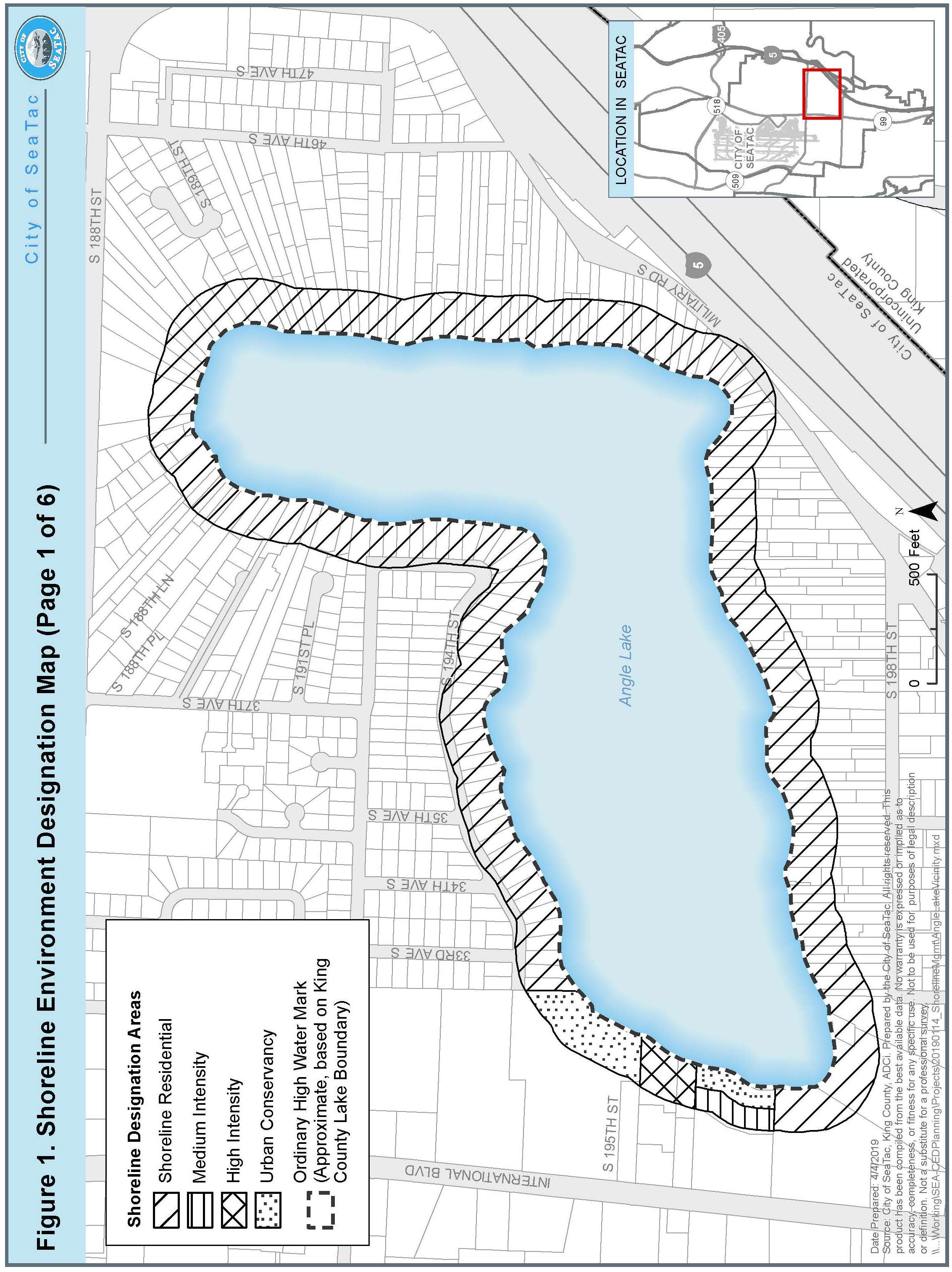

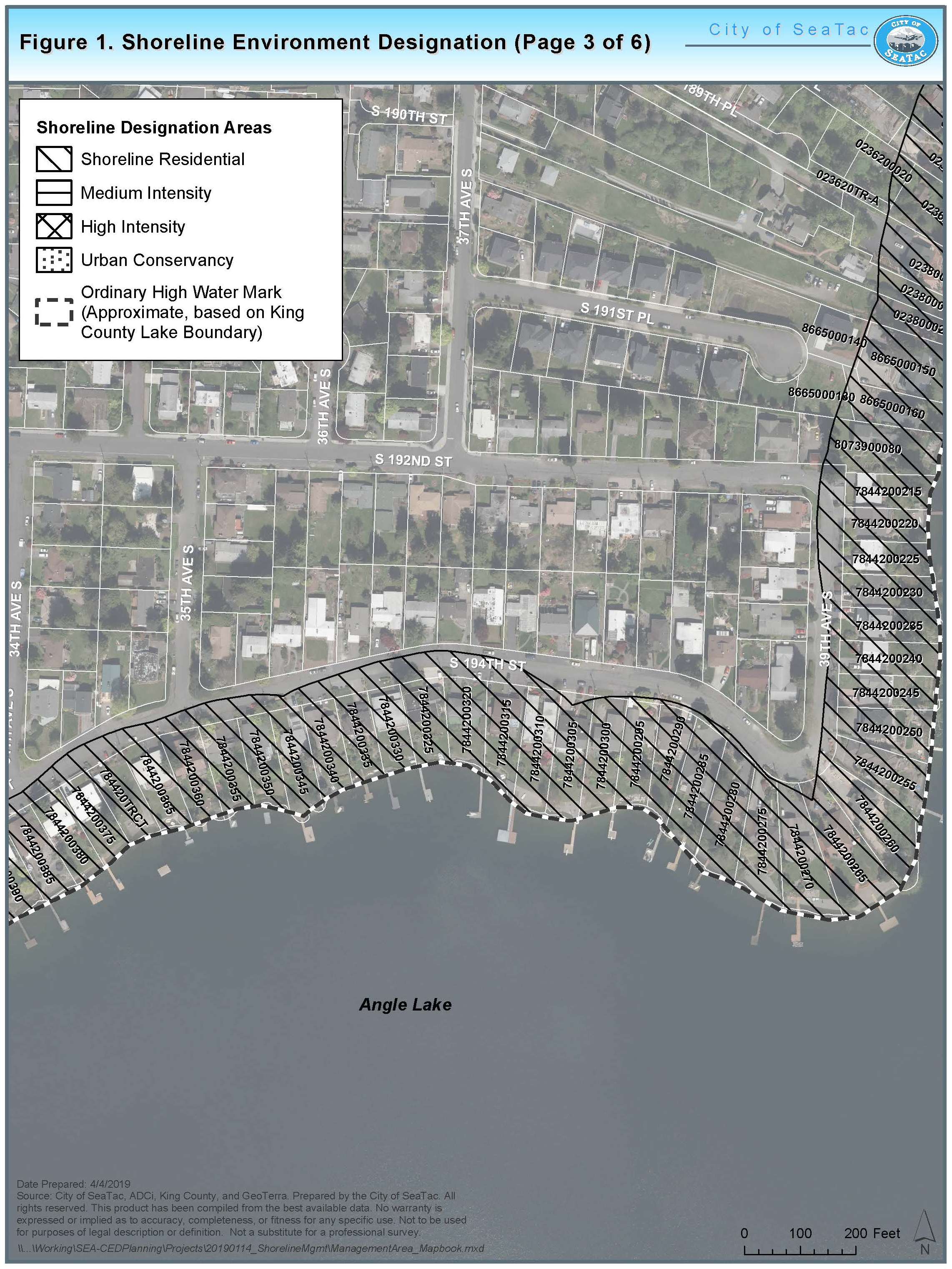
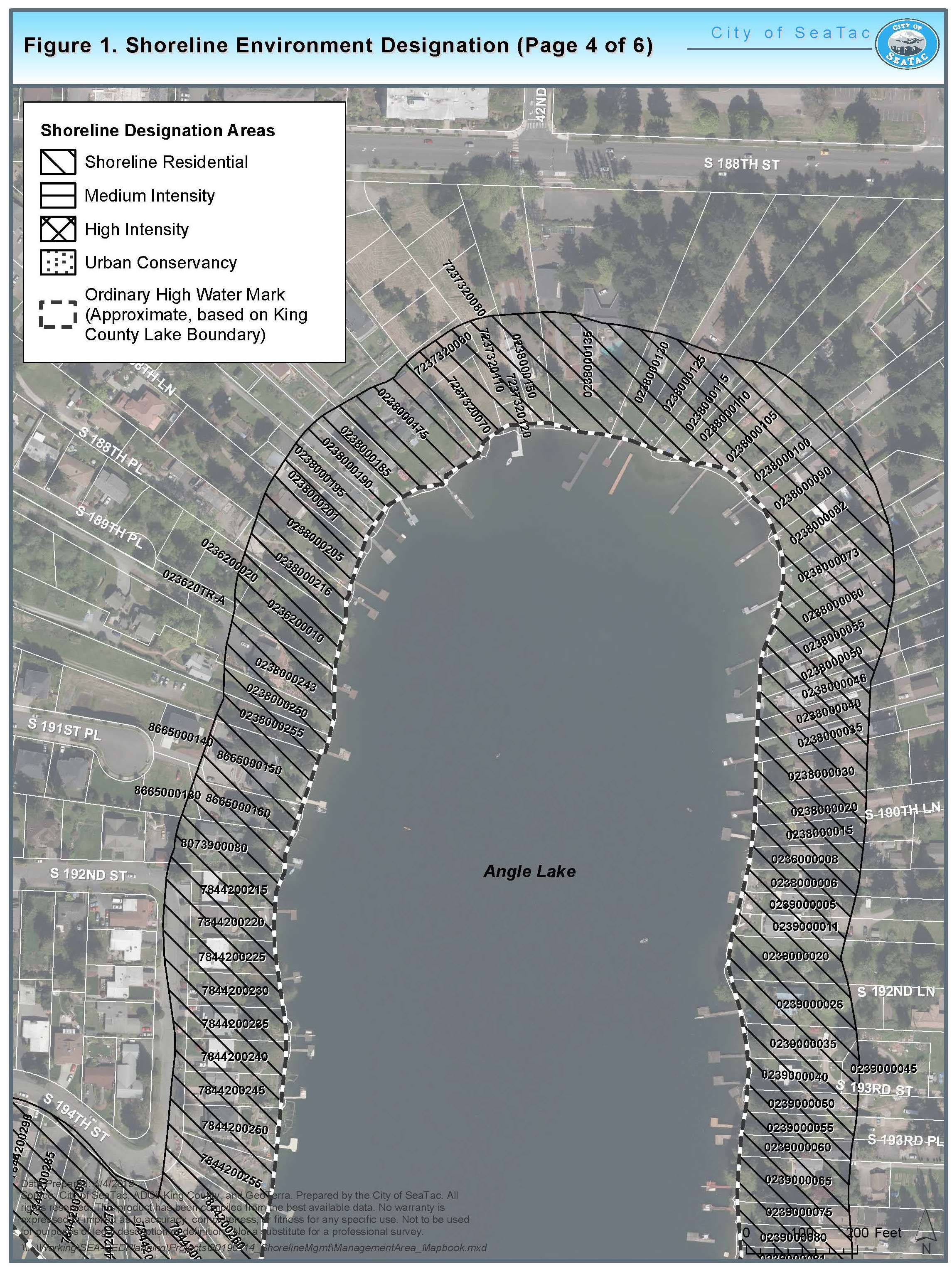
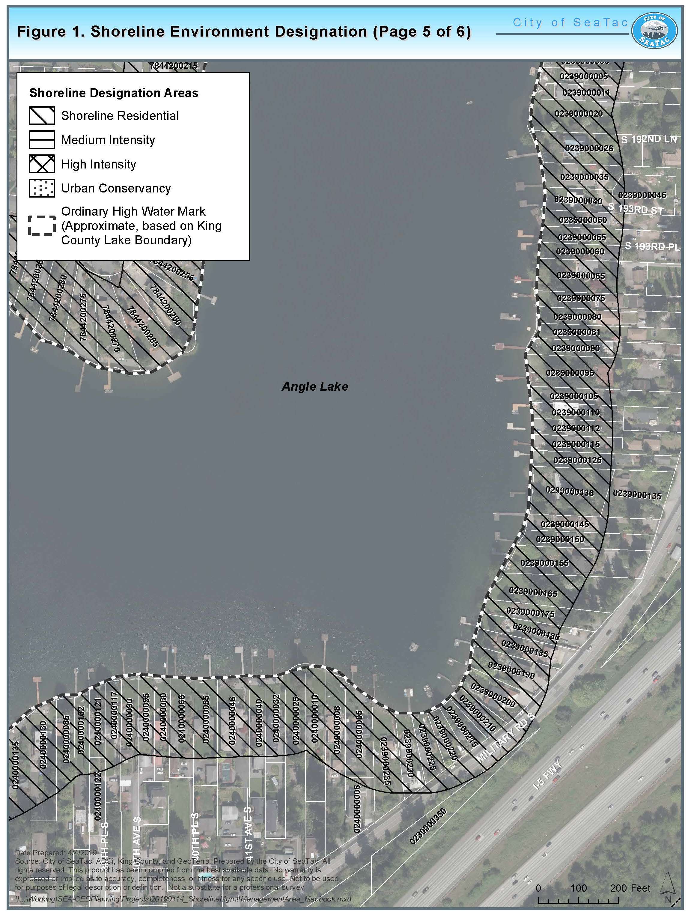
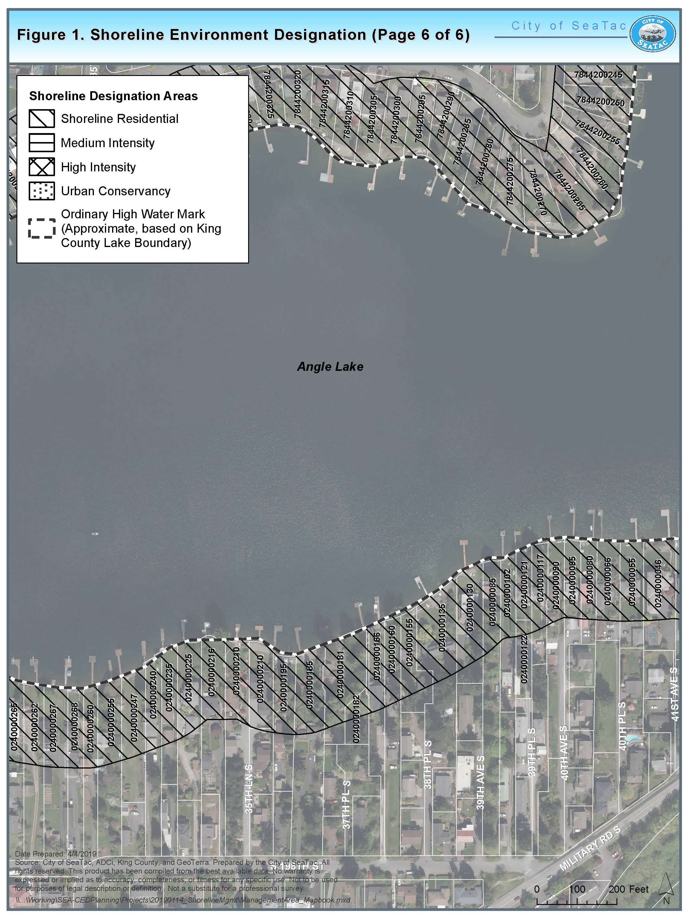
(Ord. 19-1015 § 2 (Exh. A))
Article VI. Shoreline Use Provisions
18.05.360 Introduction
As required by the Shoreline Management Act, this Master Program sets forth policies and regulations governing specific categories of uses and activities typically found in shoreline areas. The policies and regulations cover the following uses and activities: agriculture, aquaculture, boating facilities, commercial development (primary and accessory), forest practices, manufacturing development, mining, parking (as a primary use), recreational facilities, residential development, scientific, historical, cultural, or educational uses, signage, transportation, and utilities (primary and accessory). The policies and regulations, which provide basic criteria for evaluating shoreline permit applications, are used to implement the broader goals, policies and intent of the Shoreline Management Act and this Program. (Ord. 19-1015 § 2 (Exh. A Ch. 6))
18.05.370 Shoreline Use Standards
KEY
P = Permitted Use (Shoreline Exemption or Substantial Development Permit)
C = Conditional Use
X = Prohibited
Shoreline uses are allowed only if the underlying zoning allows the use.
|
Shoreline Uses |
High- Intensity |
Medium- Intensity |
Shoreline Residential |
Urban Conservancy |
Aquatic |
|---|---|---|---|---|---|
|
Agriculture |
X |
X |
X |
X |
X |
|
Aquaculture |
X |
X |
X |
X |
X |
|
Boating Facilities |
|
|
|
|
|
|
(Public or serving 4 or more residences) |
P |
P |
C |
C |
X |
|
Commercial Development |
|||||
|
Primary |
P |
X |
X |
X |
X |
|
Accessory |
P |
P |
P* |
C |
X |
|
Forest Practices |
X |
X |
X |
X |
X |
|
Manufacturing |
X |
X |
X |
X |
X |
|
Mining |
X |
X |
X |
X |
X |
|
Parking |
|||||
|
As a Primary Use |
X |
X |
X |
X |
X |
|
As an Accessory Use |
P |
P |
P |
C |
X |
|
Recreational Facilities |
|||||
|
Water-Oriented |
P |
P |
P |
P |
P |
|
Non-Water-Oriented |
|
|
|
|
X |
|
As a Primary Use |
X |
X |
X |
X |
X |
|
As an Accessory Use |
P |
P |
P |
P |
X |
|
Multi-Use Trails |
P |
P |
C |
C |
X |
|
Minor Trails |
P |
P |
P |
P |
X |
|
Residential Development |
|||||
|
Single-Family |
P |
P |
P |
X |
X |
|
Multi-Family |
P |
P |
P* |
X |
X |
|
Scientific, Historical, Cultural, or Educational Uses |
P |
P |
P |
P |
P |
|
Transportation Facilities |
|||||
|
New Roads Related to Permitted Shoreline Activities |
C |
C |
C |
C |
X |
|
Expansion of Existing Circulation Systems and Driveways |
P |
P |
C |
C |
X |
|
Utilities (Primary) |
|||||
|
Solid Waste Disposal or Transfer Sites (excluding storage of recyclable materials) |
X |
X |
X |
X |
X |
|
Other |
C |
C |
C |
C |
C |
|
Utilities (Accessory) |
|||||
|
Local Public Water, Electric, Natural Gas Distribution, Public Sewer Collection, Cable and Telephone Service, and Appurtenances |
P |
P |
P |
P |
C |
*Only if the use is permitted in the underlying zoning classification.
(Ord. 19-1015 § 2 (Exh. A § 6.1))
18.05.380 Specific Shoreline Use Regulations
A. Agriculture.
1. Applicability. “Agriculture” refers to livestock, crop, vegetation and soil management. These activities are not applicable to the City of SeaTac. There are no known agricultural activities of significance within the shoreline jurisdiction. If such activities are established in the future, regulations will be established by amendment to this Program.
2. Regulations. Agriculture is a prohibited use activity within shoreline jurisdiction.
B. Aquaculture.
1. Applicability. Aquaculture is the farming or culturing of food fish or other aquatic plants and animals in lakes, streams and other natural or artificial water bodies. These activities are not applicable to the City of SeaTac. There are no known aquaculture activities existing or anticipated within the shoreline jurisdiction. If such activities are established in the future, regulations will be established by amendment to this Program.
2. Regulations. Aquaculture is prohibited within all shoreline environments.
C. Boating Facilities.
1. Applicability. Boating facilities include public or private dry storage and wet-moorage facilities and structures; boat launch ramps, covered moorage, boat houses, mooring buoys, and marine travel lifts. Boating facilities as defined in this SMP do not apply to residential moorage facilities serving four (4) or fewer single-family residences.
Accessory uses found in boating facilities may include fuel docks and storage, boating equipment sales and rental, wash-down facilities, fish cleaning stations, repair services, public launching, bait and tackle shops, potable water, waste disposal, administration, parking, groceries and dry goods.
2. Policies.
a. Boating facilities should be located, designed, and operated to provide maximum feasible protection and restoration of ecological processes and functions and all forms of aquatic, littoral, or terrestrial life.
b. To the extent possible, boating facilities should be located in areas of low biological productivity.
c. Boating facilities should be located and designed so their structures and operations will be aesthetically compatible with the area visually affected and will not unreasonably impair shoreline views. However, the need to protect and restore functions and to provide for water-dependent uses carries higher priority than the protection of views.
3. Regulations.
a. New boating facilities shall not significantly impact the rights of navigation on the waters of the State.
b. Boating facilities shall not be located where their development would reduce the quantity or quality of critical aquatic habitat or where significant ecological impacts would occur.
c. Public launch ramps shall, where feasible, be located only on stable shorelines where water depths are adequate to eliminate or minimize the need for dredging, filling, beach enhancement or other maintenance activities.
d. It is the applicant’s responsibility to comply with all State agency policies and regulations, including all applicable health, safety and welfare requirements associated with the primary use or accessory use.
e. The traffic generated by such a facility must be safely and conveniently handled by the streets serving the proposed facility.
f. No liveaboards or floating homes are allowed.
g. The facility must be limited to day moorage only.
h. Covered moorage is prohibited.
i. Public access shall be required, pursuant to the public access regulations contained in Article IV of this chapter.
j. The perimeter of parking, dry moorage, and other storage areas shall be landscaped with native or drought tolerant landscaping or vegetated LID BMPs to provide a visual and noise buffer between adjoining dissimilar uses or scenic areas.
k. The facility must have provisions available for cleanup of accidental spills of contaminants.
D. Commercial Development.
1. Applicability. “Commercial development” means those uses that are involved in wholesale, retail, service and business trade.
2. Policies.
a. Water-dependent and multi-use commercial projects that include some combination of ecological restoration, public access, open space and recreation should be encouraged in the High-Intensity environment.
b. Commercial developments should incorporate low impact development techniques into all new development.
3. Regulations.
a. Commercial uses that are water-dependent, water-related, and water-enjoyment uses (in that order) shall be given priority over non-water-oriented uses in those shoreline environments and zones where commercial uses are allowed.
b. Commercial uses that are water enjoyment and water related may also be allowed, provided public access is provided (see SMC 18.05.220, Public Access) for new development, ecological restoration is incorporated into the project where feasible and impacts to existing navigation, recreation and public access are avoided.
c. New non-water-oriented commercial uses are prohibited unless they are part of a mixed-use project and the use provides a significant public benefit with respect to SMA objectives.
d. Primary commercial uses are permitted outright only in the High-Intensity environment.
e. Commercial uses may be allowed in the Medium-Intensity environment provided they are ancillary to the primary use.
f. Commercial development may be allowed in the Urban Conservancy environment as an accessory use to a permitted recreational use or facility. Examples of limited accessory commercial uses to permitted recreational uses and/or facilities are as follows:
i. Concession stands;
ii. Booths associates with festivals sponsored by the City, and private parties or receptions and banquets.
g. Overwater commercial development is prohibited except in existing structures, where necessary to support water-dependent uses or accessory water-dependent recreation activities that support a commercial use.
h. Other than those allowed in subsection (D)(3)(c) of this section, commercial vendors may not establish business facilities in shoreline jurisdiction. This prohibition does not preclude a vendor from being hired to provide services in connection with a permitted use.
i. Home occupations are allowed within the Shoreline Residential environment provided they meet the requirements of SMC 15.465.500, Home Occupations.
j. Low impact development techniques shall be incorporated into new development as feasible, pursuant to the City’s adopted Surface Water Design Manual and the Low Impact Development Technical Guidance Manual for Puget Sound or successor.
E. Forest Practices.
1. Applicability. Forest practices are those activities not covered by the Forest Practices Act involving conversion to non-forest use. Due to the lack of timber harvest potential within the City’s shoreline jurisdiction, these activities are not applicable to SeaTac. There are no known forest practices existing or anticipated within shoreline jurisdiction. If such operations are established in the future, regulations will be established by amendment to this Program.
2. Regulations. Forest practices are a prohibited use activity within shoreline jurisdiction.
F. Manufacturing.
1. Applicability. Manufacturing developments are facilities for processing, manufacturing and storage of finished or semi-finished goods and foodstuffs. Economic development, in the form of manufacturing activities, is not supported by the Shoreline Management Goals established for this Master Program. There are no known manufacturing activities existing or planned within shoreline jurisdiction. The adopted SeaTac Comprehensive Plan does not provide for any industrial uses along the shoreline in the future. If such operations are established in the future, regulations will be established by amendment to this Program.
2. Regulations. Manufacturing is prohibited within all shoreline environments.
G. Mining.
1. Applicability. Mining is the removal of naturally occurring materials from the earth for beneficial uses. There are no mining activities existing or anticipated within the shoreline jurisdiction. If such uses are established in the future, regulations will be established by amendment to this Program.
2. Regulations. Mining is a prohibited use activity within shoreline jurisdiction.
H. Parking.
1. Applicability. Parking is the temporary storage of automobiles or other motorized vehicles. The following provisions apply only to parking that is accessory to a permitted shoreline use. Parking as a primary use and parking which serves a use not permitted in shoreline jurisdiction is prohibited.
2. Policies.
a. Parking in shoreline areas should be minimized.
b. Parking facilities in shoreline areas should be located and designed to minimize adverse impacts including those related to stormwater runoff, water quality, visual qualities, public access, and vegetation and habitat maintenance, and shall result in no loss of ecological functions.
c. Parking in shoreline areas should not restrict access to the site by necessary public safety vehicles, utility vehicles, or other vehicles requiring access to shoreline properties.
3. Regulations.
a. Parking as a primary use is prohibited in shoreline jurisdiction.
b. Parking in shoreline areas must directly serve a permitted shoreline use.
c. Parking facilities shall provide adequate provisions, including LID BMPs, to control stormwater runoff to prevent it from contaminating water bodies.
d. Parking facilities serving individual buildings on the shoreline shall be located landward from the principal building being served, except when the parking facility is within or beneath the structure and adequately screened with native and drought tolerant landscaping or vegetated LID BMPs or in cases when an alternate orientation would have less adverse impact on the shoreline.
e. Exterior parking facilities shall be designed and landscaped with native and drought tolerant landscaping or vegetated LID BMPs to minimize adverse impacts upon adjacent shoreline and abutting properties. Exterior parking facilities for nonresidential uses shall be landscaped with native and drought tolerant landscaping in such a manner that plantings provide an effective “full-screen” within three (3) years of project completion when viewed from adjacent areas within shoreline jurisdiction.
f. New and reconstructed parking areas within the shoreline environment shall utilize low impact development (LID) where feasible based on design criteria pursuant to the Surface Water Design Manual.
I. Recreational Development.
1. Applicability. Recreational uses include passive activities, such as walking, viewing and fishing. Recreational development also includes facilities for active uses, such as swimming, boating, and other outdoor recreation uses. This section applies to both public and private noncommercial shoreline recreational facilities (excluding private residences) in SeaTac.
2. Policies.
a. Recreational uses in the shoreline jurisdiction should be limited to water-oriented uses. Non-water-oriented recreational facilities may be allowed as an accessory use in limited circumstances where they support water-oriented uses and do not displace water-oriented uses.
b. The coordination of local, State and Federal recreation planning should be encouraged. Shoreline recreational developments should be consistent with the City’s park and recreation plans.
c. Recreational developments should be designed to preserve, enhance or create scenic views and vistas.
d. The use of publicly owned lands for public access and development of recreational opportunities should be encouraged.
e. The City encourages land acquisitions for open space that provide wildlife habitat and offer opportunities for education and interpretation within shoreline jurisdiction.
f. Shoreline areas with a potential for providing recreation or public access opportunities should be identified and acquired by lease or purchase, or through partnerships with nonprofit and service organizations, and incorporated into the park and open space system.
g. Links between existing and future shoreline parks, recreation areas and public access points should be created with a non-motorized trail system through acquisition of easements and/or land.
h. Recreational activities should be designed to avoid conflict with private property rights, and to minimize and mitigate negative impacts on adjoining property.
i. Public access should not contribute to a net loss of shoreline ecological functions.
3. Regulations.
a. All structures associated with a recreational use, water-dependent structures, such as docks and boardwalks, and appurtenances that provide access to the water for that use, must comply with all standards in this SMP, including required shoreline setbacks established in Article V of this chapter, Table I. Shoreline setbacks may be reduced in accordance with SMC 18.05.340, Flexible Shoreline Setback Regulations. However, existing structures may be replaced in their current location and configuration to the extent allowed by State and Federal agencies with jurisdiction. Any further setback reduction shall require approval of a shoreline variance application.
b. Private and public recreation areas shall protect existing native vegetation in the shoreline area and restore vegetation impacted by development activities. Recreational use and development shall result in no net loss of shoreline ecological functions. Mitigation shall be provided as necessary to meet this requirement. Failure to meet this standard will result in permit denial. The City may request necessary studies by qualified professionals to determine compliance with this standard.
c. Water-dependent or water-related activities such as swimming, boating, and fishing, and activities that benefit from waterfront scenery such as picnicking, hiking and bicycling, shall be emphasized in planning public and private (excluding residential) noncommercial recreation sites in the shoreline corridor.
d. All recreational developments shall make adequate provisions for:
i. Non-motorized and pedestrian access;
ii. The prevention of trespass onto adjacent properties, including but not limited to landscaping and fencing;
iii. Protection and restoration of environmentally sensitive areas and shoreline processes and functions;
iv. Signs indicating the public’s right of access to shoreline areas, installed and maintained in conspicuous locations at the point of access and the entrance; and
v. Buffering of such development from adjacent private property or natural area with native and drought tolerant landscaping or vegetated LID BMPs.
e. In approving shoreline recreational developments, the City shall ensure that the development will maintain, enhance or restore desirable shoreline features.
f. Swimming areas shall be separated from boat launch areas.
g. The construction of swimming facilities, piers, moorages, floats and launching facilities waterward of the OHWM shall be governed by the regulations relating to overwater structure construction in Article VII of this chapter, Shoreline Modification Provisions.
h. Public boat launching facilities may be developed, provided the traffic generated by such a facility can be safely and conveniently handled by the streets serving the proposed facility.
i. Fragile and unique shoreline areas with valuable ecological functions, such as wildlife habitats, shall be used only for non-intensive recreation activities that do not involve the construction of structures.
j. Recreation developments such as golf courses and playfields that require periodic use of fertilizers, pesticides or other chemicals, or that support high-intensity activities as a primary use, such as sporting events, shall be located outside of shoreline jurisdiction.
k. Proposals for new or expanded recreational development shall include provisions for public access to the shoreline.
l. A new or expanded shoreline recreational development or use that does not provide public access may be authorized provided it is demonstrated by the applicant and determined by the City that one (1) or more of the following provisions apply:
i. Unavoidable health or safety hazards to the public exist which cannot be prevented by any practical means;
ii. Inherent security requirements of the proposed development or use cannot be satisfied through the application of alternative design features or other solutions;
iii. The cost of providing the access, easement, or an alternative amenity is unreasonably disproportionate to the total long-term cost of the proposed development;
iv. Unacceptable environmental harm such as damage to fish spawning areas will result from the public access which cannot be mitigated; or
v. Significant undue and unavoidable conflict between the proposed access and adjacent uses would occur and cannot be mitigated.
vi. Provided further, that the applicant has first demonstrated and the City of SeaTac has determined that all reasonable alternatives have been exhausted, including but not limited to:
(A) Regulating access by such means as limiting hours of use to daylight hours.
(B) Designing separation of uses and activities, with such means as fences, terracing, hedges, native and drought tolerant landscaping, and vegetated LID BMPs.
(C) Providing access that is physically separated from the proposal, such as an off-site viewpoint, or a trail system.
vii. Whenever a requirement of subsections (I)(3)(l)(i) through (vi) of this section cannot be met, the City shall, as a condition of granting a permit, require the applicant to make an in-lieu-of payment in accordance with RCW 82.02.020.
J. Residential Development.
1. Applicability. Residential development means one (1) or more buildings, structures, lots, parcels, or portions thereof which are designed for and used or intended to be used to provide a place of abode for human beings, including single-family residences and other detached dwellings together with accessory uses and structures normally applicable to residential uses located landward of the OHWM, including, but not limited to, swimming pools, garages, sheds, fences and saunas.
Residential development is prohibited in the Aquatic environment and Urban Conservancy environment. Single-family and multi-family development is limited to those underlying zones that currently allow it and subject to the requirements therein.
2. Policies.
a. Residential development should be permitted only where there are adequate provisions for utilities, circulation and access.
b. Recognizing the single purpose, irreversible and space consumptive nature of shoreline residential development, new development should provide adequate setbacks and natural buffers from the water and ample open space among structures to protect natural features, preserve views and minimize use conflicts.
c. The City should provide development incentives, including reduced shoreline setbacks, to encourage the protection, enhancement and restoration of high functioning buffers and natural or semi-natural shorelines.
d. Residential development should be designed to preserve shoreline aesthetic characteristics, views, and minimize physical impacts to shoreline ecological functions.
e. Residential development should be designed so as to preserve existing shoreline vegetation, control erosion and protect water quality using best management practices and, where possible, utilizing low impact development technologies.
f. The City encourages the use of joint use piers and docks in lieu of individual piers and docks for each waterfront lot to protect the ecological functions of the lake.
g. The City should encourage the use of alternative paving products, such as pervious pavers, as a mechanism for reducing impervious surfaces and surface water runoff.
h. Development should, at a minimum, achieve no net loss of ecological functions necessary to sustain shoreline natural resources, even for exempt development.
3. Regulations.
a. Residential development is permitted in the High-Intensity, Medium-Intensity, and Shoreline Residential environments subject to the policies and regulations for the specific shoreline environment (see Article V of this chapter, Table I, the standards of the underlying zoning regulations and the general regulations in Article IV of this chapter).
b. Structures or other development accessory to residential uses is permitted in shoreline jurisdiction, if allowed under all other applicable standards in this SMP and subject to the provisions of the City’s zoning code.
c. All additions to residential structures must comply with all standards in this SMP, including required shoreline setbacks established in Article V of this chapter, Table I.
d. Residential structures that are intentionally modified, replaced, repaired or enlarged are subject to the requirements in SMC 18.05.480 (Nonconforming Use and Development Standards). These standards include, but are not limited to, compliance with all standards in this SMP for new and existing structures or portions of structures, including required shoreline setbacks established in Article V of this chapter, Table I, when proposed development exceeds fifty percent (50%) of the fair market replacement cost of existing development.
e. Residential structures that are intentionally modified, replaced or repaired following a catastrophic loss are subject to the requirements in SMC 18.05.480 (Nonconforming Use and Development Standards). These standards include, but are not limited to, compliance with all standards in this SMP for new and existing structures or portions of structures, including required shoreline setbacks established in Article V of this chapter, Table I, when proposed development exceeds seventy-five percent (75%) of the fair market replacement cost of existing development.
f. Accessory uses and appurtenant structures not specifically addressed in the SMP shall be subject to the same regulations as primary residences.
g. In order to maintain visual access to the waterfront, fences within the required setback from the OHWM shall be:
i. No more than four (4) feet high when separating two (2) residential lots and no more than six (6) feet high when separating a residential lot from a park or commercial use; and
ii. May not extend beyond the OHWM.
h. To protect views and vistas maximum height limits have been established for each shoreline environment as indicated in Article V of this chapter, Table I, Summary of Shoreline Dimensional Standards. In addition to the restrictions stated therein, development over thirty-five (35) feet shall require a view corridor study indicating that the proposed structure would not diminish views of the lake from surrounding properties.
i. The stormwater runoff for all new or redevelopment shall include LID BMPs where feasible pursuant to the Surface Water Design Manual.
j. Residential development shall result in no net loss of shoreline ecological functions. Mitigation shall be provided as necessary to meet this requirement. Failure to meet this standard will result in permit denial. The City may request necessary studies by qualified professionals to determine compliance with this standard.
K. Signs.
1. Applicability. A sign is defined as a device of any material or medium, including structural component parts, which is used or intended to be used to attract attention to the subject matter for advertising, identification or informative purposes. The following provisions apply to any commercial or advertising sign directing attention to a business, professional service, community, site, facility, or entertainment, conducted or sold either on or off premises.
2. Policies.
a. Signs should be designed and placed so that they are compatible with the aesthetic quality of the existing shoreline and adjacent land and water uses.
b. Signs should not block or otherwise interfere with visual access to the water or shorelines.
c. Outdoor advertising and billboards are not an appropriate use of the shoreline area within shoreline jurisdiction.
3. Regulations.
a. Signs shall comply with the City’s sign regulations.
b. Sign plans and designs shall be submitted for review and approval at the time of shoreline permit approval.
c. All signs shall be located and designed to minimize interference with vistas, viewpoints and visual access to the shoreline.
d. Temporary or obsolete signs shall be removed within ten (10) days of elections or termination of any other functions. Examples of temporary signs include: real estate signs, directions to events, political advertisements, event or holiday signs, and construction signs.
e. Signs that do not meet the policies and regulations of this Program shall be removed or required to conform within two (2) years of the adoption of this Master Program.
f. Allowable Signs. The following types of signs may be allowed in all shoreline environments:
i. Water navigational signs and highway signs necessary for operation, safety and direction.
ii. Public information signs directly relating to a shoreline use or activity.
iii. Off-premises, freestanding signs for community identification, information, or directional purposes.
iv. National, site and institutional flags or temporary decorations customary for special holidays and similar events of a public nature.
g. Prohibited Signs. The following signs are prohibited:
i. Off-premises detached outdoor advertising signs.
ii. Spinners, streamers, pennants, flashing lights, and other animated signs used for commercial purposes.
iii. Signs placed on trees or other natural features.
iv. Commercial signs for products, services, or facilities located off site.
L. Transportation Facilities.
1. Applicability. Transportation facilities are those structures and developments that aid in land, air, and water surface movement of people, goods, and services. They include roads and highways, bridges, bikeways, trails, heliports, and other related facilities. In SeaTac, these uses account for a minimal percentage of the shoreline land inventory. However, the impact of these facilities on shorelines can be substantial.
2. Policies.
a. Normal operation and maintenance of all roadways in shoreline jurisdiction should be exempt.
b. New road construction in the shoreline jurisdiction should be minimized, and allowed by conditional use only when related to and necessary for the support of permitted shoreline activities.
c. Expansion of existing roadways should be allowed by conditional use if such facilities are found to be in the public interest.
d. Joint use of transportation corridors within the shoreline jurisdiction for roads, utilities and motorized and nonmotorized forms of transportation should be encouraged, where feasible.
3. Regulations.
a. New road construction in shoreline jurisdiction shall be minimized and allowed only when related to and necessary for the support of permitted shoreline activities.
b. Transportation facility development shall result in no net loss of shoreline ecological functions. Mitigation shall be provided as necessary to meet this requirement. Failure to meet this standard will result in permit denial.
c. Expansion of existing roadways within the shoreline jurisdiction shall be allowed only when the proponent demonstrates that:
i. No alternative route is feasible;
ii. The roadway is constructed and maintained to cause the least possible adverse impact on the land and water environment; and
iii. The roadway is found to be in the public interest.
d. Transportation and primary utility facilities shall be required to make joint use of rights-of-way, and to consolidate crossings of water bodies to minimize adverse impacts to the shoreline.
e. Developers of roads must be able to demonstrate that efforts have been made to coordinate with existing land use plans including the Shoreline Master Program and the City’s Comprehensive Plan.
f. All debris and other waste materials from roadway construction shall be disposed of in such a way as to prevent their entry into any water body.
g. Road designs must provide safe pedestrian and nonmotorized vehicular crossings where public access to shorelines is intended.
h. Streets within shoreline jurisdiction shall be designed with the minimum pavement area required. Gravel and more innovative materials shall be used where feasible for pathways and road shoulders to minimize the amount of impervious surfaces and help to maintain a more natural appearance.
i. The City shall give preference to mechanical means for roadside brush control on roads in shoreline jurisdiction rather than the use of herbicides.
M. Utilities (Primary).
1. Applicability. Utilities are services and facilities that produce, transmit, store, process or dispose of electric power, gas, water, sewage, and communications. Utilities in this SMP are divided into primary and accessory based on type and scale. The provisions of this section apply to primary use and activities such as solid waste handling and disposal, water transmission lines, sewage treatment facilities and mains, power generating or high voltage transmission facilities, gas distribution lines and storage facilities, stormwater mains and regional stormwater treatment facilities.
2. Policies.
a. New primary utilities should be located outside of the shoreline jurisdiction unless no other feasible option exists. Where allowed they should utilize existing transportation and utility sites, rights-of-way and corridors whenever possible, rather than creating new corridors. Joint use of rights-of-way and corridors should be encouraged.
b. Solid waste disposal activities and facilities should be prohibited in shoreline areas. “Solid waste facilities” are not to be construed as storage of recyclable materials.
c. Primary utilities should avoid locating in environmentally sensitive areas unless no feasible alternatives exist.
d. Wherever primary utility facilities and corridors must be placed in a shoreline area, they should be located so as to protect scenic views. Whenever possible, such facilities should be placed underground or designed to minimize impacts on the aesthetic qualities of the shoreline area.
3. Regulations.
a. Primary utilities shall be located outside of shoreline jurisdiction unless no other feasible option exists.
b. Primary utilities shall be located landward of the ordinary high water mark unless such location is not feasible or would result in potentially greater environmental impacts.
c. Primary utility facilities shall avoid disturbance of unique and fragile areas, as well as wildlife spawning, nesting and rearing areas. Utility facility development shall result in no net loss of shoreline ecological functions. Mitigation shall be provided as necessary to meet this requirement. Failure to meet this standard will result in permit denial.
d. Utility development shall, through coordination with local government agencies, provide for compatible, multiple use of sites and rights-of-way. Such uses include shoreline access points, trail systems and other forms of recreation and transportation, providing such uses will not unduly interfere with utility operations, endanger public health and safety or create a significant and disproportionate liability for the owner.
e. Utility lines shall utilize existing rights-of-way, shared trenches, corridors and/or bridge crossings whenever possible and shall avoid duplication and construction of new corridors in all shoreline areas. Proposals for new corridors or water crossings must fully substantiate the infeasibility of existing routes.
f. Solid waste disposal sites and facilities are prohibited in the shoreline environment.
g. Where major facilities must be placed in a shoreline area, the location and design shall be chosen so as not to destroy or obstruct scenic views.
h. Primary utility development shall provide screening of facilities from water bodies and adjacent properties. Screening, including native and drought tolerant landscaping or vegetated LID BMPs and fencing, shall be designed to constitute a dense “full screen.”
i. Clearing of vegetation for the installation or maintenance of utilities shall be kept to a minimum and upon project completion any disturbed areas shall be restored to their pre-project condition.
j. The City shall hold public meetings prior to the issuance of a substantial development permit for a major primary utility project in accordance with the administrative procedures outlined in this Master Program to allow for the greatest amount of public input to help guide utility-related decisions.
N. Utilities (Accessory).
1. Applicability. Utilities have been split into accessory and primary with “accessory” meaning utilities that affect small-scale distribution services connected directly to the uses along the shoreline. For example, power distribution, telephone, cable, water and sewer service lines, stormwater collection and conveyance are all considered as utilities accessory to shoreline uses. They are covered in this section because they concern all types of development and have the potential of impacting the ecological condition and visual quality of the shoreline and its waters.
2. Policies.
a. Utilities are necessary to serve shoreline uses and should be properly installed to protect the shoreline and water from contamination and degradation.
b. Utility facilities and rights-of-way should be located outside of the shoreline area to the maximum extent possible. When utility lines require a shoreline location, they should be placed underground, where feasible.
c. Utility facilities should be designed and located in a manner which preserves the natural landscape and shoreline ecology, and minimizes conflicts with present and planned land uses.
3. Regulations.
a. Utility developments shall, through coordination with local government agencies, provide for compatible, multiple uses of sites and rights-of-way. Such uses include shoreline access points, trail systems, and other forms of recreation and transportation, providing such uses will not unduly interfere with utility operations, or endanger public health and safety.
b. In shoreline areas, accessory utilities shall be placed underground and in shared trenches unless demonstrated to be infeasible. Further, such lines shall utilize existing rights-of-way, and existing corridors whenever possible.
c. Utility facilities shall be located and designed to avoid destruction of, or damage to, important wildlife areas, and other unique and fragile areas. Utility facility development shall result in no net loss of shoreline ecological functions. Mitigation shall be provided as necessary to meet this requirement. Failure to meet this standard will result in permit denial.
d. Clearing for the installation or maintenance of utilities shall be kept to a minimum, and upon project completion, any disturbed area shall be restored, to the greatest extent feasible, to pre-project conditions, including replanting with native species, or other species as approved by the City, and maintenance care. If the previous condition is identified as being undesirable for shoreline function, then landscaping and other improvements shall be undertaken.
e. The location and construction of outfalls shall comply with all appropriate Federal, State, County and City regulations.
f. The City shall maintain, enhance and restore public natural drainage systems to protect water quality, reduce flooding, reduce public costs and prevent associated environmental degradation for no net loss of shoreline ecological functions.
g. New utility lines including electricity, communications, and fuel lines shall be located underground and in shared trenches unless demonstrated to be infeasible. Existing above ground lines shall be moved underground when properties are redeveloped or in conjunction with major system upgrades or replacements.
h. Utility development shall include public access to the shoreline, trail systems, and other forms of recreation, providing such uses will not unduly interfere with utility operations, endanger the public health, safety, and welfare, or create a significant and disproportionate liability for the owner.
i. Proposals for new utility corridors shall fully substantiate the infeasibility of existing routes. (Ord. 19-1015 § 2 (Exh. A § 6.2))
Article VII. Shoreline Modification Provisions
18.05.390 Introduction
Shoreline modification activities are those actions that modify the physical configuration or qualities of the shoreline area. Shoreline modification activities are, by definition, undertaken in support of or in preparation for a permitted shoreline use. A single use may require several different shoreline modification activities.
Shoreline modification activity policies and regulations are intended to assure, at a minimum, no net loss of ecological functions necessary to sustain shoreline natural resources and to prevent, reduce and mitigate the negative environmental impacts of proposed shoreline modifications consistent with the goals of the Shoreline Management Act. A proposed development must meet all of the regulations for both applicable uses and activities as well as the general and environment designation regulations.
This article has been divided into three (3) sections: Shoreline Stabilization, Dredging and Fill, and Overwater Structures. (Ord. 19-1015 § 2 (Exh. A § 7.1))
18.05.400 Table of Shoreline Modification Activities
A. Interpretation of Shoreline Modification Table. The shoreline modification table below determines whether a specific shoreline modification is allowed within each of the shoreline environments. See standards following the table for a full explanation of activities and required conditions for permitted activities. The shoreline environment is located on the vertical column of the table and the specific modification is located on the horizontal row of the table.
B. The table should be interpreted as follows:
1. If the letter “X” appears in the box at the intersection of the column and the row, the modification is not allowed in that shoreline environment.
2. If the letter “P” appears in the box at the intersection of the column and the row, the modification may be allowed through a shoreline exemption or a shoreline substantial development permit, within the shoreline environment only if the underlying zoning allows the modification.
3. If the letter “C” appears in the box at the intersection of the column and the row, the modification may be allowed within the shoreline environment subject to the shoreline conditional use review procedures specified in Article VIII of this chapter, and only if the underlying zoning allows the modification.
C. Note that Medium- and High-Intensity environments are located along water bodies that do not generally accommodate navigation. No overwater structures exist in these areas currently, and future demand for overwater structures is not anticipated. These activities are therefore prohibited in these two (2) shoreline environments.
|
Shoreline Modification Activity |
High-Intensity |
Medium-Intensity1 |
Shoreline Residential |
Urban Conservancy (tax parcel 042204-9002) |
Urban Conservancy (tax parcel 042204-9009) |
Aquatic |
|---|---|---|---|---|---|---|
|
CLEARING AND GRADING |
P |
P |
P |
P |
C |
See adjacent upland environment |
|
SHORELINE STABILIZATION |
|
|
|
|
|
|
|
Beach Restoration and Enhancement |
P |
N/A |
P |
C |
C |
|
|
Soil Bio-engineering |
P |
P |
P |
P |
P |
|
|
Bulkheads |
X |
N/A |
P |
C |
X |
|
|
Breakwaters, Jetties, and Groins |
X |
N/A |
X |
X |
X |
|
|
DREDGING AND FILL |
|
|
|
|
|
|
|
Dredging |
C |
N/A |
C |
C |
C |
|
|
Fill |
C |
N/A |
C |
C |
C |
|
|
OVERWATER STRUCTURES |
|
|
|
|
|
|
|
Accessory to Residential Structures2: |
|
|
|
|
|
|
|
Recreational Float |
P |
N/A |
P |
N/A |
C |
|
|
Boathouse |
X |
N/A |
X |
N/A |
X |
|
|
Joint Use Pier, Dock, Float, Buoy, Moorage Pile |
P |
N/A |
P |
N/A |
C |
|
|
Non-Joint Use Pier, Dock, Float |
X |
N/A |
C |
N/A |
X |
|
|
Overwater Walkway |
C |
N/A |
X |
N/A |
C |
See adjacent upland environment |
|
Launching Ramp |
X |
N/A |
X |
N/A |
N/A |
|
|
Launching Rails |
X |
N/A |
X |
N/A |
N/A |
|
|
Boat Lifts |
X |
N/A |
X |
N/A |
N/A |
|
|
Boat Canopies |
X |
N/A |
X |
N/A |
N/A |
|
|
Moorage Covers |
X |
N/A |
X |
N/A |
N/A |
|
|
Not Accessory to Residential Structures: |
|
|
|
|
|
|
|
Recreational Float |
X |
N/A |
C |
C |
C |
|
|
Boathouse |
X |
N/A |
X |
C |
X |
|
|
Joint Use Pier, Dock, Float |
C |
N/A |
P |
P |
C |
|
|
Non-Joint Use Pier, Dock, Float |
X |
N/A |
C |
X |
X |
|
|
Overwater Walkway |
C |
N/A |
X |
C |
C |
|
|
Launching Ramp |
X |
N/A |
X |
P |
X |
|
|
Launching Rails |
X |
N/A |
X |
P |
X |
|
|
Boat Canopies |
X |
N/A |
X |
X |
X |
|
|
Moorage Covers |
X |
N/A |
X |
X |
X |
1 The Medium-Intensity shoreline environment is located one hundred (100) feet from the OHWM on tax parcel 042204-9009 so regulations for shoreline stabilization and overwater structures are not applicable (N/A).
2 Note these regulations are not applicable (N/A) either where the specific shoreline environment does not front the shoreline or where residential structures are not allowed in that environment or in an adjacent parallel environment.
(Ord. 19-1015 § 2 (Exh. A § 7.2))
18.05.410 Shoreline Stabilization
A. Applicability. Shoreline stabilization includes actions taken to address erosion impacts to property caused by natural processes, such as current, flood, wake or wave action. These actions include all structural and nonstructural methods. “Hard” structural stabilization measures refer to those with solid, hard surfaces, such as concrete or boulder bulkheads, while “soft” structural measures rely on less rigid materials, such as bioengineered vegetation measures or beach enhancement. Nonstructural methods include building setbacks, relocation of the structure to be protected, ground water management, planning and regulatory measures to avoid the need for structural stabilization.
Generally, the harder the construction measure, the greater the impact on shoreline processes, including sediment transport, geomorphology, and biological functions. The means taken to reduce damage caused by erosion, accretion, and flooding must recognize the positive aspects of each of these processes in order to retain the benefits of these natural occurrences. Erosion does not occur without accretion (deposition and accumulation) of material eroded, such as formation of a beach or a sandbar. Likewise, accretion cannot occur unless material has been eroded.
Specific structural methods for stabilization include beach restoration and enhancement, soil bioengineering, bulkheads, and groins along Angle Lake. A key regulatory distinction in this SMP is made between new stabilization measures and the replacement of existing stabilization measures. New stabilization measures include the enlargement of existing structures. Some of these techniques are currently being used in SeaTac as described below, or they are techniques that could be used to address local shoreline issues.
General policies and regulations addressing shoreline stabilization methods applicable to the City are presented in the following sections. Additional discussion of the individual stabilization methods, and policies and regulations specific to them, is provided following the general policies and regulations section.
1. Beach Restoration or Enhancement on Angle Lake. Beach enhancement is the alteration of exposed and submerged shorelines for the purpose of stabilization, recreational enhancement, and/or aquatic habitat creation or restoration using native or similar material. The materials used are dependent on the intended use. For recreational purposes, various grades of clean sand or pea gravel are often used to create a beach above the ordinary high water mark. Restoration or re-creation of a shore feature may require a rock and gravel matrix and/or creation of other materials appropriate for the intended use.
2. Soil Bioengineering. Soil bioengineering is the term given to the practice of using natural vegetative materials to stabilize shorelines and prevent erosion. This may include use of bundles of stems, root systems, or other living plant material; fabric or other soil stabilization techniques; and limited rock toe protection, where appropriate. Soil bioengineering projects often include fisheries habitat enhancement measures such as anchored logs or root wads, in project design. Soil bioengineering techniques may be applied to shoreline areas and the upland areas away from the immediate shoreline.
The use of soil bioengineering as a shoreline stabilization technique is a viable and proven alternative to riprap, concrete and other structural solutions. It provides habitat while maintaining and preserving the natural character of the shoreline. Soil bioengineering is the preferred “best practices” choice when considering shoreline stabilization.
3. Bulkheads. Bulkheads are shoreline structures, either sloped or vertical, usually constructed parallel to the shore. The primary purpose they serve is to contain and prevent the loss of soil caused by erosion or wave action.
Bulkheads have historically been constructed of poured-in-place or precast concrete, concrete blocks, steel or aluminum sheet piling, wood or wood and structural steel combinations, and boulders. Bulkheads may be either thin structures penetrating deep into the ground or more massive structures resting on the surface.
Uses and activities related to bulkheads which are identified as separate use activities in this Program, such as fill and residential development, are subject to the regulations for those uses in addition to the standards for bulkheads established in this section.
4. Groins. Groins are barrier-type structures of rock, wooden piling or other materials constructed across the beach itself and extending into the water with the intent to obstruct sand and sediment carried by the littoral drift action along shorelines. Groins have limited applicability in SeaTac’s shoreline jurisdiction because of the relatively small size of Angle Lake.
B. General Policies.
1. Proposals for shoreline stabilization activities should address the impact of these activities on the shoreline environment. This planning should consider off-site erosion, accretion, or damage that might occur as a result of shoreline stabilization structures or activities.
2. Explore a range of solutions to reduce the amount of bulkheads and shoreline armoring over time around Angle Lake and restore natural bank conditions. Alternative methods to typical shoreline armoring using native vegetation and other natural shoreline features should be the preferred method where feasible.
3. Non-structural stabilization measures are preferred over “soft” structural measures. Soft structural shoreline stabilization measures are strongly preferred over hard structural shoreline stabilization. Proposals for hard and soft structural solutions, including bulkheads, should be allowed only when it is demonstrated that nonstructural methods are not feasible. Hard structural shoreline stabilization measures should be allowed only when it is demonstrated that soft structural measures are not feasible.
4. Structural shoreline stabilization should be permitted only when it has been demonstrated that shoreline stabilization is necessary for the protection of existing legally established structures, primary uses and public improvements, and that there are no other feasible options to the proposed shoreline stabilization that have less impact on the shoreline environment.
5. Shoreline stabilization structures should be located, designed and constructed to minimize adverse impact on the property of others.
6. New development requiring bulkheads or similar protection should not be allowed. All new shoreline development should be located and designed to prevent or minimize the need for shoreline modification activities.
7. Mitigation for shoreline stabilization should be provided to achieve no net loss of ecological functions necessary to sustain shoreline natural resources.
C. Regulations.
1. General Shoreline Stabilization – New Development.
a. New development, including the division of land into new parcels, shall, where feasible, be located and designed to eliminate the need for concurrent or future shoreline stabilization. New non-water-dependent development that would require shoreline stabilization that would cause significant adverse impacts to adjacent or down-current properties is prohibited.
b. New development, including single-family residences, that includes structural shoreline stabilization will not be allowed unless all of the conditions below are met:
i. The need to protect the development from damage due to erosion caused by natural processes, such as currents and waves, and by manmade processes, such as boat wakes, is demonstrated through a geotechnical report.
ii. The erosion is not being caused by upland conditions, such as loss of vegetation and drainage.
iii. Non-structural measures, such as placing the development farther from the shoreline, planting vegetation, low impact development measures, or installing on-site drainage improvements, are not feasible or not sufficient.
iv. The stabilization structure will not result in a net loss of shoreline ecological functions.
c. New development on steep or unstable slopes shall be set back sufficiently to ensure that shoreline stabilization will not be needed during the life of the structure, as demonstrated by a geotechnical analysis prepared by a geotechnical engineer or related professional licensed and in good standing in the State of Washington.
2. General Shoreline Stabilization – Basic Requirements. Structural solutions to reduce shoreline damage from erosion shall be allowed only after it is demonstrated through a geotechnical report that non-structural solutions would not provide sufficient protection to existing improvements. The geotechnical report shall evaluate the necessity of structural stabilization measures by estimating time frames and rates of erosion (damage within three (3) years), urgency of replacement, alternative solutions and other pertinent factors. Non-structural solutions include (but are not limited to) soil bioengineering, beach enhancement, alternative site designs, drainage improvements and increased building setbacks (for proposed structures).
3. General Shoreline Stabilization – New or Expanded Measures. New structural stabilization measures and enlargement of existing structural stabilization measures shall be limited to the minimum size necessary and shall be permitted only when it has been conclusively demonstrated through scientific analysis that shoreline stabilization is necessary to protect existing primary structures, public improvements, ecological function restoration projects or hazardous substance remediation projects from erosion, and that nonstructural measures, planting vegetation, or installing on-site drainage improvements is not feasible or not sufficient.
4. General Shoreline Stabilization – Replacement and Repair. An existing shoreline stabilization structure shall not be replaced with a similar structure unless there is a demonstrated need to protect legally established principal uses or existing structures from erosion caused by currents or waves and a nonstructural measure is not feasible.
a. Shoreline stabilization solutions developed to replace existing shoreline stabilization shall be placed along the same alignment as, or landward of, the shoreline stabilization being replaced, except as noted below.
b. Where existing structural stabilization is replaced by non-structural shoreline stabilization using bioengineering techniques and results in a documented improvement of shoreline functions, such stabilization may be allowed waterward of the ordinary high water mark subject to State and Federal approvals.
5. Shoreline Stabilization – Design Requirements.
a. Shoreline stabilization and modification projects shall avoid and then minimize adverse impacts to the environment to the greatest extent feasible, and where such impacts cannot be avoided, mitigation shall be provided to achieve no net loss of shoreline ecological functions.
b. Shoreline stabilization should not be used to create new or newly usable land.
c. Shoreline stabilization shall not significantly interfere with normal surface and/or subsurface drainage into the water body.
d. Shoreline stabilization shall be designed so as not to constitute a hazard to navigation and to not substantially interfere with visual access to the water.
e. Shoreline stabilization shall be designed so as not to not cause a significant impact to adjacent properties, including the need for shoreline stabilization elsewhere.
f. Professional design (as approved by the City) of all shoreline stabilization is required. All shoreline modification activities shall be in support of a permitted shoreline use that is in conformance with the provisions of this Master Program unless it can be demonstrated that such activities are necessary and in the public interest.
g. All shoreline modification activities must comply with all other regulations as stipulated by State and Federal agencies, local tribes, or others that have jurisdiction.
h. Alternative methods to typical shoreline armoring using native vegetation and other natural shoreline features shall be considered when replacing existing and constructing new shoreline stabilization solutions.
i. Public access shall be required as part of publicly financed shoreline stabilization measures unless public access improvements would cause unavoidable health or safety hazards to the public, inherent and unavoidable security problems, unacceptable and unmitigable significant ecological impacts, unavoidable conflict with proposed use, or a cost that is disproportionate and unreasonable to the total long-term cost of the development.
6. Beach Enhancement.
a. Beach enhancement along Angle Lake may be permitted when the applicant has demonstrated that the project will not detrimentally interrupt littoral processes, redirect waves, current, or sediment to other shorelines, or adversely affect adjacent properties or habitat and all other standards of the SMP are followed.
b. Beach enhancement is limited to the placement of no more than twenty-five (25) cubic yards of material below the ordinary high water mark. Proposals which exceed this threshold shall be subject to the requirements for shoreline fill in this article, shall require a conditional use permit and shall only be allowed in conjunction with a water-dependent or public use permitted by this Master Program, and for fisheries, aquaculture, or wildlife enhancement projects.
c. Natural Beach Restoration/Enhancement Design Standards. Natural beach restoration/enhancement shall not:
i. Extend waterward more than the minimum amount necessary to achieve the desired stabilization;
ii. Disturb significant amounts of valuable shallow water fish/wildlife habitat without appropriate mitigation of the impacts.
d. Natural Beach Restoration Construction Standards.
i. The size and/or mix of new materials to be added to a beach shall be as similar as possible to that of the natural beach sediment, but large enough to resist normal current, wake, or wave action at the site.
ii. The restored beach shall approximate, and may slightly exceed, the natural beach width, height, bulk or profile (but not as much as to create additional dry land).
e. Beach enhancement is prohibited within fish and/or wildlife spawning, nesting, or breeding habitat that would be adversely affected by it and also where littoral drift of the enhancement materials would adversely affect adjacent spawning grounds or other areas of biological significance.
7. Soil Bioengineering.
a. All soil bioengineering projects shall use native plant materials appropriate to the specific area including trees, shrubs, and ground covers, unless demonstrated infeasible for the particular site.
b. Unless environmentally sensitive area regulations apply, all cleared areas shall be replanted with native vegetation immediately following construction and irrigated (if necessary) to ensure that within three (3) years all vegetation is one hundred percent (100%) reestablished to achieve no net loss of ecological functions of the shoreline area. Areas that fail to adequately reestablish vegetation shall be replanted with approved plant materials until such time as the plantings are viable. Additional performance standards may be established by the Shoreline Administrator in administrative rules.
c. Bank stabilization in the form of a vegetated buffer zone shall be maintained (e.g., weeding, watering, dead plant replacement) for a minimum of three (3) years. The buffer zone shall exclude activities that could disturb the site. Where determined necessary by the Shoreline Administrator, fencing may be required to ensure protection of buffer plantings.
d. All construction and planting activities shall be scheduled to minimize impacts to water quality and fish and wildlife aquatic and upland habitat, and to optimize survival of new vegetation.
8. Breakwaters. Breakwaters, jetties, and groins shall not be permitted.
9. Bulkheads.
a. Bulkhead design and development shall conform to all other applicable local, State, and Federal agency regulations, including regulations for shoreline stabilization in this article.
b. On all shorelines, bulkheads shall not be placed waterward of the ordinary high water mark (OHWM), unless as provided below. In addition:
i. On shorelines where no other bulkheads are adjacent, the construction of a bulkhead shall tie in with the contours of the adjoining shorelines, as feasible, such that the proposed bulkhead would not cause erosion of the adjoining properties.
ii. Bulkheads may tie in flush with existing bulkheads on adjoining properties; provided, that the new bulkhead does not extend waterward of the OHWM, except that which is necessary to make the connection to the adjoining bulkhead. In such circumstances, the remaining portion of the bulkhead shall be placed landward of the existing OHWM such that no net loss of lake occurs and the design complies with all other regulations as stipulated by State and Federal agencies, local tribes, or others that have jurisdiction.
iii. Replacement bulkheads shall not encroach waterward of the ordinary high water mark or existing structure unless the residence was occupied prior to January 1, 1992, and there are overriding safety or environmental concerns. In such cases, the replacement structure shall abut the existing shoreline stabilization structure.
c. Replacement bulkheads may be permitted if there is a demonstrated need to protect principal uses or structures from erosion caused by waves; provided, that:
i. The replacement bulkhead is designed, located, sized, and constructed to assure no net loss of ecological functions.
ii. The existing bulkhead is removed.
iii. The proposal includes a report prepared by a geotechnical engineer or other qualified professional that evaluates the necessity of the bulkhead by estimating time frames and rates of erosion, urgency of replacement (within three (3) years), alternative solutions and other pertinent factors.
d. New bulkheads shall be allowed only for existing structures when evidence is presented through a report prepared by a geotechnical engineer or other qualified professional that conclusively demonstrates that one (1) of the following conditions exists:
i. Bulkheads are necessary to the operation and location of water-dependent and water-related activities consistent with this Master Program; provided, that all alternatives have proven infeasible (i.e., use relocation, use design, nonstructural shore stabilization options) and that such bulkheads meet other policies and regulations of this article; or
ii. Serious wave erosion threatens an existing building(s) on upland property; and
iii. Proposals for bulkheads have first demonstrated that use of natural materials and processes (soft structural solutions) and alternative site designs, including increased shoreline setbacks (nonstructural solutions), are either not feasible or will not provide the necessary protection for existing development.
e. When a bulkhead is required at a public access site, provisions for safe access to the water shall be incorporated into bulkhead design.
f. Stairs or other permitted structures may be built into a bulkhead, but shall not extend waterward of a bulkhead.
g. Fill behind bulkheads shall be limited to an average of one (1) cubic yard per running foot of bulkhead. Any filling in excess of this amount shall be considered a regulated activity subject to the policies and regulations in this SMP pertaining to fill activities and the requirement for obtaining a shoreline substantial development permit. (Ord. 19-1015 § 2 (Exh. A § 7.3))
18.05.420 Dredging and Fill
A. Applicability. Although these activities may occur separately from one another, they are often all parts of the same shoreline modification process and are, therefore, considered together in the following policies and regulations.
1. Dredging and Dredge Material Disposal. Dredging is the removal or displacement of earth or sediments such as gravel, sand, mud or silt and/or other materials or debris from any stream, or lake and associated shorelines, side channels, and wetlands. In a lake setting, dredging is normally done for specific purposes or uses such as deepening a navigational channel or obtaining bottom material.
Dredge material is disposed of on land or into water bodies and may be intended for the purpose of creating new or additional lands for other uses. Dredge spoil varies from clean river sand to organic sludge. While some of this material is deposited on land, a significant portion is dumped, intentionally or unintentionally, back into the water or immediately adjacent to the water.
Of all activities on shorelines, dredging poses one (1) of the greatest threats to water quality and aquatic life. In most cases, dredging occurs in shallow areas and may disturb the aquatic environment in the following ways: (a) temporary reduction of water clarity from suspended sediments, (b) loss of aquatic plants and animals by direct removal or from the sedimentation of suspended materials, (c) alteration of the nutrient and oxygen levels of the water column, and (d) suspension of toxic materials from the sediments into the water column.
2. Fill. Fill is the placement of soil, sand, rock, gravel, sediment, earth retaining structure or other material to an area waterward of the OHWM, in wetlands, or on shorelands in a manner that raises the elevation or creates dry land.
Fill is usually considered in locations where the water is shallow and where rooted vegetation often occurs. In their natural condition, these same areas provide valuable habitat for fish and wildlife feeding, breeding, and shelter. Biologically, the shallow vegetation areas tend to be highly productive portions of the lake. For these reasons, governmental agencies and scientific experts have generally sought to prohibit or restrict fill.
The policies contained herein are intended to focus on the aspects of natural systems affected by dredging and the disposal of dredge material, manmade fill, cuts, excavations and site grading actions, while at the same time recognizing the community’s needs.
B. Policies.
1. Dredging.
a. Dredging should only be allowed as a conditional use in all shoreline environments. Dredging should be restricted to the minimum necessary to support water-dependent uses, for expansion or alteration of public utility facilities, and for environmental restoration and enhancement projects, and only when other solutions would result in greater environmental impact.
b. Dredging waterward of the ordinary high water mark for the primary purpose of obtaining fill should not be allowed, except as part of a restoration or environmental cleanup project.
c. In all cases, dredging operations should be planned and conducted to protect and maintain existing aquatic habitat and other shoreline uses, properties, and values.
d. Dredging operations should be designed and scheduled to avoid impacts to fish, including impacts to fish rearing, feeding and spawning.
e. Dredging and dredge material disposal should be located and conducted in a manner that minimizes damage to existing ecological values and natural resources of the area to be dredged and of the disposal site. Proposals that include dredging should provide mitigation to achieve no net loss of shoreline ecological functions.
f. Dredge material disposal in water bodies should be prohibited.
g. Dredging should utilize techniques that cause minimal dispersal and broadcast of bottom material should be utilized, such as hydraulic dredging instead of agitation dredging.
h. The City may impose limitations on dredging activities, such as limited operating hours, time periods, and requirements for buffer strips at the site.
2. Fill.
a. Shoreline fill should be permitted as a conditional use in all shoreline environments.
b. Fills waterward of the OHWM should be restricted to the minimum necessary to support water-dependent uses, public access, cleanup and disposal of contaminated sediments as part of an interagency cleanup plan, disposal of dredged sediments in accordance with Department of Natural Resources (DNR) rules, expansion or alteration of transportation facilities of statewide significance when no other alternatives are feasible, and for mitigation actions, environmental restoration and enhancement projects, and only when other solutions would result in greater environmental impact.
c. Shoreline fills should be designed and located so that there will be no significant damage to existing ecological systems or natural resources, and no alteration of local currents, surface and subsurface drainage, or flood waters which would result in hazard to adjacent life, property, or natural resource systems.
d. Where permitted, fill coverage should be the minimum necessary to provide for the proposed use. Fills should be permitted only when tied to a specific development proposal that is permitted by the Master Program.
e. In evaluating fill projects, factors such as current and potential public use of the shoreline and water surface area, water flow and drainage, water quality and habitat should be considered and protected to the maximum extent feasible. Further, the City should assess the overall value of the fill site in its present state versus the proposed shoreline use to be created to ensure consistency with the Shoreline Management Act and this Master Program.
f. The perimeter of fills should be designed to avoid or eliminate erosion and sedimentation impacts, both during initial fill activities and over time. Natural appearing and self-sustaining control methods are preferred over structural methods.
g. Replenishing sand and gravel on public and private beaches should be allowed, if it can be demonstrated that the proposal will result in no net loss of ecological functions.
h. Sanitary landfills should not be located in shoreline jurisdiction.
C. Regulations.
1. Dredging.
a. Dredging and disposal of dredge material shall avoid, and minimize, significant ecological impact; impacts that cannot be avoided shall be mitigated to achieve no net loss of ecological processes and functions.
b. New development siting and design shall avoid the need for new and maintenance dredging.
c. Dredging may be permitted as a conditional use activity only:
i. When necessary to support a water-dependent use;
ii. For expansion or alteration of public utility facilities;
iii. As part of mitigation actions, environmental restoration and habitat enhancement projects;
iv. When technical information demonstrates water circulation, littoral drift, aquatic life and water quality will not be substantially impaired;
v. When other solutions would result in greater environmental impact;
vi. As part of an approved habitat improvement project;
vii. If it improves water quality; and
viii. When applicable permits of other local, State and Federal agencies have been obtained.
d. When dredging is permitted, the extent of dredging shall be the minimum necessary to accommodate the proposed use.
e. Maintenance dredging associated with a water-dependent use shall be restricted to maintaining the previously dredged and/or existing authorized location, depth and width.
f. Dredging for the primary purpose of obtaining fill or construction material is prohibited, except for projects associated with MTCA or CERCLA habitat restoration, or any other significant restoration effort approved by a shoreline conditional use permit. When dredging is allowed for fill materials, placement of fill must be waterward of the OHWM.
g. Proposals for dredging and dredge disposal shall include details on all feasible mitigation measures to protect aquatic habitats. Dredging and dredge disposal shall not create a net loss of shoreline ecological functions.
h. Dredging material which will not subsequently cause violation of State water quality standards may be used in permitted landfill projects.
i. Excavations on beaches below the OHWM in lands covered by water constitute dredging and shall include precautions to prevent the migration of fine grain sediments, disturbed by the excavation, onto adjacent beach areas. Excavations on beaches shall be backfilled promptly using material of similar composition and similar or coarser grain size.
j. Dredging shall be timed so that it does not interfere with aquatic life.
k. Depositing dredge materials in water areas shall be prohibited.
l. Dredging shall utilize techniques (such as hydraulic dredging instead of agitation dredging) that cause minimal dispersal and broadcast of bottom material.
m. Limitations may be imposed on dredging activities, such as limited operating hours, time periods, and requirements for buffer strips at the site.
2. Fill.
a. Fills waterward of the OHWM (not including small scale beach restoration that does not exceed the twenty-five (25) cubic yard threshold established in SMC 18.05.410(C)(6)(b)) shall require a conditional use and shall be restricted to the minimum necessary to:
i. Support water-dependent uses;
ii. Provide public access;
iii. Allow for the remediation and disposal of contaminated sediments as part of an interagency cleanup plan;
iv. Allow the disposal of dredged sediments in accordance with DNR rules;
v. Provide for the expansion or alteration of transportation facilities of statewide significance when no other alternatives are feasible; and
vi. Accomplish mitigation actions, environmental restoration and enhancement projects, and only when other solutions would result in greater environmental impact.
b. Fills shall be designed, constructed, and maintained to prevent, minimize, and control all material movement, erosion, and sedimentation from the affected area.
c. All perimeters of fills shall be provided with vegetation, retaining walls, or other satisfactory mechanisms for erosion prevention and sediment capture.
d. Fill proposals must demonstrate, at a minimum, that they will result in no net loss of shoreline ecological functions.
e. Fill shall be permitted only where it is demonstrated that the proposed action will not:
i. Result in significant damage to water quality, fish, aquatic habitat, and/or wildlife habitat; or
ii. Adversely alter natural drainage and circulation patterns, or significantly reduce flood water holding capabilities.
f. No refuse disposal sites, solid waste disposal sites, or sanitary fills shall be permitted along the Angle Lake shoreline.
g. Any placement or removal of materials landward of the OHWM shall comply with the provisions of SMC 18.05.240, Vegetation Conservation (Clearing and Grading). (Ord. 19-1015 § 2 (Exh. A § 7.4))
18.05.430 Overwater Structures – Piers, Docks, Floats and Buoys
A. Applicability. Piers and docks are structures which abut the shoreline and are often used as a landing or moorage place for watercraft. Piers are built on fixed platforms supported by piles above the water, while docks float upon the water. Some piers may terminate in a float section that is connected by a ramp.
Recreational floats are independent anchored off-shore platforms, used for water-dependent recreational activities such as swimming and diving.
Certain mooring structures such as moorage piles, buoys and boat lifts are not generally used on Angle Lake since an eight (8) mph speed limit and a “no wake rule” generally result in only small craft using the lake.
All of these types of facilities have positive and negative environmental aspects. Floating docks generally have less of a visual impact than piers on pilings. However, in the nearshore, docks can interrupt littoral drift of sediments and other suspended materials, and significantly shade the aquatic environment throughout their length. Pile piers can provide diverse habitat for both desirable and undesirable aquatic life. Excavated moorage involves dredging and will disturb bottom sediments and aquatic life. Docks and piers alike create impediments to boat traffic and fish travel. Pier construction requires regulation to protect navigation, to protect shoreline aesthetics, and to maintain the usable water surface and aquatic lands for life forms characteristic and important to those areas.
B. Exemptions. The City will review all development proposals for piers to determine if:
1. The proposal is or is not exempt from the requirement for a substantial development permit per SMC 18.05.470(D);
2. The proposal is suitably located and designed and that all potential impacts have been recognized and mitigated such that there is no net loss of shoreline ecological functions; and
3. The proposal is consistent with the intent, policies, and regulations of the Act, RCW 90.58.10(12), and this Master Program.
C. Policies.
1. New piers and docks should be allowed only for public access and water-dependent uses.
2. New piers and docks should be restricted to the minimum size necessary and permitted only when the applicant has demonstrated that a specific need exists to support the intended water-dependent use.
3. Piers and docks should be discouraged where conflicts with recreational boaters and other recreational water activities would be created by pier construction.
4. The further proliferation of single-purpose, single-owner piers and docks should be discouraged. Preference should be given to the shared use piers in shoreline areas by requiring a conditional use permit in the Shoreline Residential environment for piers and docks serving one (1) dwelling unit, allowing joint use structures as a permitted use in the Shoreline Residential environment and requiring shared use docks and piers in all other environments.
5. A pile-supported walkway should only be allowed within the Urban Conservancy and High-Intensity shoreline environments. Mitigation should be required to ensure no net loss of ecological functions.
6. Substantial additions or alterations to overwater structures, including renovations where the cost of the development exceeds fifty percent (50%) of the fair market value of the existing structure, should be in conformance with all policies and regulations set forth in this Master Program.
7. Preference should be given to fixed-pile piers elevated above the OHWM. Floating docks should be allowed if the applicant can demonstrate why a fixed-pile pier is not feasible or will result in greater impacts.
8. Recreational floats should be allowed where they are intended to support public or private recreational uses, or in lieu of fixed piers adjacent to residential land uses.
9. New moorage covers should not be allowed.
10. Overwater structures, including piers, should only be authorized after consideration of:
a. The effect such structures have on wildlife and aquatic life, water quality, scenic and aesthetic values, environmental sensitive resources, submerged lands, and submerged vegetation.
b. The effect such structures have on water circulation, recreational boating, sediment movement and littoral drift and shoreline access.
11. Overwater structures and mooring buoys should be designed to cause minimum interference with navigable waters and the public’s safe use of the lake and shoreline.
12. Use of non-reflective materials in construction should be encouraged.
13. The proposed size of the structure and intensity of use or uses of any overwater structure should be compatible with the surrounding environment and land and water uses.
14. Lighting facilities should be limited to the minimum extent necessary to locate the pier or dock at night.
D. Regulations.
1. General.
a. All new, reconstructed, repaired, or modified overwater structures must comply with all regulations contained in this SMP and all other regulations as stipulated by State and Federal agencies, local tribes, or others that have jurisdiction.
b. Mitigation shall be provided for all reconstructed, repaired, or modified overwater structures to ensure no net loss of ecological function.
c. New piers and docks shall be allowed only for public access and water-dependent uses, which includes a structure associated with a single-family residence; provided, that it is designed and intended as a facility for access to watercraft and otherwise complies with the regulations contained in this section.
d. New piers and docks that are not accessory to single-family residences shall be permitted only when intended for public use or when the applicant has demonstrated that a specific need exists to support the intended water-dependent use.
e. New residential development of more than two (2) dwellings shall provide a joint use or community moorage structure, rather than individual piers or docks.
f. New piers and docks associated with a single-family home shall be allowed, provided the applicant demonstrates that a joint use or community pier is not feasible.
g. New proposed moorage structures in the Shoreline Residential environment that are not joint use structures must obtain a conditional use permit. Additional restrictions apply for some shoreline environments pursuant to Table III. A conditional use permit may be granted if:
i. The applicant demonstrates that a joint use or community moorage structure is not feasible;
ii. The overwater structure does not create any potential adverse impacts to public safety;
iii. Navigation rights are not significantly impacted;
iv. The overwater structure does not cause environmental impacts that cannot be sufficiently mitigated; and
v. The overwater structure complies with all other conditional use criteria in WAC 173-27-160 as outlined in Article VIII of this chapter.
h. Proposed overwater structures which do not comply with the dimensional standards contained in this article may only be approved if they obtain a variance.
i. Fixed-pile piers elevated at least two (2) feet above the OHWM shall be preferred. Floating docks shall be allowed if floating elements are not located within the first thirty (30) feet of the shoreline measured waterward of the OHWM, unless the applicant can demonstrate why adherence to this restriction is not feasible and an alternative design would result in less ecological impact.
j. All float tubs shall be fully encapsulated and the decks shall be fully grated except for the float tubs, designed with a ramp section connecting to the upland and are prohibited from resting on the substrate. Floating docks are required to be designed to not ground during low water conditions.
k. All overwater structures shall be constructed and maintained in a safe and sound condition. Abandoned or unsafe overwater structures shall be removed or repaired promptly by the owner.
l. Wooden components that will be in contact with water or over water shall not be treated or coated with herbicides, fungicides, paint, pentachloraphenol, arsenate, creosote, or similar toxic substances. Structures shall be made out of materials that have been approved by applicable State and Federal agencies.
m. Boat houses are not permitted, except in Angle Lake Park, where a conditional use permit is required.
n. Moorage covers are not permitted.
o. Boat canopies are not permitted.
p. Boat lifts are not permitted.
q. No portion of a deck of a pier shall, during the course of the normal fluctuations of the elevation of the water body, protrude more than six (6) feet above the OHWM.
r. No residential dwelling unit may be constructed on a pier.
s. Piers and docks may be permitted accessory to a development provided:
i. The applicant has demonstrated to the satisfaction of the Shoreline Administrator that a shared or joint use pier is not feasible.
ii. No more than one (1) pier/dock for each single-family residence is permitted.
iii. No more than one (1) pier, dock or other moorage structure is allowed for a water-dependent commercial use or a multi-family (more than two (2) units) development on a single lot or contiguous ownership with a minimum width of fifty (50) feet.
iv. On lots with less than fifty (50) feet of waterfront, joint use piers/docks shall be required, except as follows: when lots on either side of the subject lot have legal preexisting piers or docks and the applicant demonstrates to the satisfaction of the Shoreline Administrator that a shared use agreement is not feasible. Only in this case may the lot with less than fifty (50) feet of waterfront be permitted an individual pier.
t. Moorage Structure Length.
i. All pier and dock lengths shall be minimized to the maximum extent feasible and comply with regulations as stipulated by State and Federal agencies, local tribes, or others that have jurisdiction. The proposed length must be the minimum necessary to support the intended use. The maximum waterward intrusion of any portion of any piers and docks shall be limited to the following:
(A) The maximum length of a private dock shall be determined by the point at which twelve (12) feet in water depth is reached and in no case shall a pier or dock more than eighty (80) feet be allowed without approval of a variance (note: the twelve (12) foot depth is to accommodate the three (3) to four (4) foot fluctuation in water depth caused by stormwater management practices);
(B) A report prepared by a qualified professional that includes verifiable survey information demonstrating the average water depth pursuant to the requirement above is required for all docks or piers over forty (40) feet in length;
(C) A pier of up to eighty (80) feet is allowed when public access is provided. Existing public piers may be repaired or replaced to their previous length.
u. Moorage Structure Width.
i. The maximum width of a pier or dock walkway and additional fingers shall be six (6) feet and four (4) foot walkways are recommended. All pier and dock walkways must be fully grated and ells and floats must have a minimum two (2) foot strip of grating down the center.
ii. The maximum width of a ramp connecting a pier to a float should be minimized to the maximum extent practical and should be fully grated.
iii. Size. Surface coverage, including all floats, ramps and ells, shall be limited to the following:
(A) Four hundred eighty (480) square feet for a pier of a single property owner, or four hundred (400) square feet for a dock;
(B) Six hundred (600) square feet for a joint use pier utilized by two (2) or more residential property owners, or four hundred eighty (480) square feet for a dock;
(C) Eight hundred (800) square feet for a new pier that allows public access, or six hundred forty (640) square feet for a dock. Existing public piers may be repaired or replaced to their previous square footage.
2. Overwater Walkway. An overwater walkway way be allowed in the Urban Conservancy, High-Intensity, and Aquatic environments with a conditional use permit, provided the following standards are met:
a. The applicant must first demonstrate that an upland trail connecting tax parcel 042204-9009 with Angle Lake Park is not feasible because a private party is not willing to grant said access.
b. The walkway shall be constructed on pilings, have a fully grated deck surface and conform to all applicable standards for moorage structures.
c. Maximum width shall be four (4) feet wide or as necessary to meet ADA requirements.
d. Length shall be the minimum necessary to connect tax parcel 042204-9009 and Angle Lake Park in a feasible manner that avoids impacts to ecological function; in no case shall the maximum length exceed four hundred (400) feet.
e. Maximum surface coverage shall be two thousand (2,000) square feet.
f. The walkway shall be located at an optimum water depth and elevated a minimum of two (2) feet above the OHWM to minimize impacts to ecological functions.
g. The walkway shall not substantially interfere with navigation.
h. Mitigation shall be provided to achieve no net loss of ecological function.
3. Boat Launches.
a. Launching rails may be permitted as a conditional use in the Shoreline Residential environment in lieu of a moorage pier, provided the applicant shall demonstrate that the proposed length of the rail is the minimum necessary to safely launch the intended craft and comply with all regulations as stipulated by State and Federal agencies, local tribes, or others that have jurisdiction. In no case shall the rail extend beyond the point where the water depth is ten (10) feet below the OHWM.
b. Launching rails shall be anchored to the ground with the use of tie-type construction.
c. No more than one (1) launching rail per single-family residence or duplex is permitted.
d. Launching ramps may be permitted as a conditional use for recreational uses in the Urban Conservancy environment provided the applicant shall demonstrate that the proposed length of the ramp is the minimum necessary to safely launch the intended craft and comply with all regulations as stipulated by State and Federal agencies, local tribes, or others that have jurisdiction. In no case shall the ramp extend beyond the point where the water depth is ten (10) feet below the OHWM.
e. Public boat ramps and boat ramps serving more than four (4) residential units are regulated as boating facilities and must comply with all policies and regulations in Article VI of this chapter.
4. Recreational Floats. Recreational floats may be permitted, provided:
a. The area of a recreational float shall be minimized to the maximum extent feasible and comply with regulations as stipulated by State and Federal agencies, local tribes, or others that have jurisdiction. No recreational float shall have more than two hundred (200) square feet when associated with a private recreation land use, and four hundred (400) when associated with a public recreational land use.
b. Distance Waterward from the OHWM. Recreational floats must be in water with depths of eight (8) feet or more at the landward end of the float and may be located up to a maximum waterward distance of eighty (80) feet.
c. Recreational floats shall be designed and intended for swim use or other nonmotorized use.
d. Recreational floats shall be fully grated.
e. Retrieval lines shall not float at or near the surface of the water.
f. Height. Recreational floats must be built so that the deck surface is one (1) foot above the water’s surface and they must have reflectors for nighttime visibility.
g. All float tubs shall be fully encapsulated. (Ord. 19-1015 § 2 (Exh. A § 7.5))
Article VIII. Administration
18.05.440 Introduction
There is hereby established an administrative system designed to assign responsibilities for implementation of the Master Program and shoreline permit review, to prescribe an orderly process by which to review proposals and permit applications, and to ensure that all persons affected by this Master Program are treated in a fair and equitable manner. (Ord. 19-1015 § 2 (Exh. A § 8.1))
18.05.450 Program Administrator
A. The City of SeaTac’s Community and Economic Development Director is hereby vested with:
1. Overall responsibility for administering the Shoreline Management Act and this Master Program;
2. Authority to approve, approve with conditions, or deny shoreline permit revisions in accordance with the policies and provisions of this Master Program; and
3. Authority to grant statements of exemption from shoreline substantial development permits in accordance with the policies and provisions of this Master Program.
B. The duties and responsibilities of the Shoreline Administrator shall include:
1. Preparing and using application forms deemed essential for the administration of this Master Program.
2. Advising interested citizens and applicants of the goals, policies, regulations, and procedures of this Master Program.
3. Making administrative decisions and interpretations of the policies and regulations of this Master Program and the Shoreline Management Act.
4. Collecting applicable fees, as established by the City in SMC 13.100.070.
5. Determining that all applications and necessary information and materials are provided.
6. Conducting field inspections, as necessary.
7. Reviewing, insofar as possible, all provided and related information deemed necessary for appropriate applications needs.
8. Determining if a shoreline substantial development permit, conditional use permit or variance permit is required.
9. Providing copies of permit applications to relevant staff and agencies for review and comment.
10. Conducting a thorough review and analysis of shoreline exemption applications; reviewing other staff and agency comments; making written findings and conclusions; and approving, approving with conditions, or denying such exemptions.
11. Submitting shoreline substantial development permit, shoreline variance, and conditional use permit applications and written recommendations and findings on such permits to the City’s Hearing Examiner for their consideration and action.
12. Submitting shoreline redesignation permit applications and written recommendations and findings on such permits to the Hearing Examiner for recommendation to the City Council.
13. Assuring that proper notice is given to appropriate persons and the public for all hearings.
14. Providing technical and administrative assistance to the City’s Hearing Examiner and City Council as required for effective and equitable implementation of this Program and the Act.
15. Investigating, developing, and proposing amendments to this Master Program as deemed necessary to more effectively and equitably achieve its goals and policies.
16. Enforcing and seeking remedies for alleged violations of this Program, the provisions of the Act and this Master Program or of conditions of any approved shoreline permit issued by the City of SeaTac. The Shoreline Administrator may delegate these enforcement duties to a designated representative.
17. Acting as the primary liaison between local and State agencies in the administration of the Shoreline Management Act and this Master Program.
18. Forwarding shoreline permits to the Department of Ecology for filing or action in accordance with WAC 173-27-130. (Ord. 19-1015 § 2 (Exh. A § 8.2))
18.05.460 Exceptions
Requirements to obtain a substantial development permit, conditional use permit, variance, letter of exemption, or other review to implement the Shoreline Management Act do not apply to the developments identified in WAC 173-27-044 and 173-27-045. (Ord. 19-1015 § 2 (Exh. A § 8.3))
18.05.470 Shoreline Permits and Exemptions
A. All uses and developments occurring within shoreline jurisdiction shall be compliant with Chapter 90.58 RCW.
B. A substantial shoreline development permit is required per the following guidelines:
1. A development, use, or activity shall not be undertaken within the jurisdiction of the SMA, Chapter 90.58 RCW, and this Shoreline Master Program unless it is consistent with the policy and procedures of the SMA, applicable State regulations and this Shoreline Master Program.
2. A substantial development shall not be undertaken within the jurisdiction of the SMA, Chapter 90.58 RCW, and this Shoreline Master Program unless a shoreline substantial development permit has been obtained and the appeal period has been completed and any appeals have been resolved and/or the applicant has been given permission to proceed by the proper authority.
C. The following guidelines are to be used in determining whether or not a development proposal is exempt from the substantial shoreline development permit:
1. Exemptions shall be construed narrowly. Only those developments that meet the precise terms of one (1) or more of the listed exemptions may be granted exemption from the substantial development permit process.
2. An exemption from the substantial development permit process is not an exemption from compliance with the Shoreline Management Act or this Shoreline Master Program, nor from any other regulatory requirements. To be authorized, all uses and developments must be consistent with the policies and provisions of this Shoreline Master Program and the Shoreline Management Act. A development or use that is listed as a conditional use pursuant to this Shoreline Master Program or is an unlisted use must obtain a conditional use permit even though the development or use does not require a substantial development permit. When a development or use is proposed that does not comply with the bulk, dimensional and performance standards of this Shoreline Master Program, such development or use can only be authorized by approval of a variance.
3. The burden of proof that a development or use is exempt from the permit process is on the applicant.
4. If any part of a proposed development is not eligible for exemption, then a substantial development permit is required for the entire proposed development project.
5. The City’s Shoreline Administrator may attach conditions to the approval of exempted developments and/or uses as necessary to assure consistency of the project with the Shoreline Management Act and this Shoreline Master Program.
D. Exemptions.
1. Developments which are exempt from requirements for a substantial development permit are identified in WAC 173-27-040 or as subsequently amended. The following is a short summary of the types of developments which do not require substantial development permits (see WAC 173-27-040 for detailed descriptions):
a. Any development of which the total cost or fair market value, whichever is higher, does not exceed seven thousand forty-seven ($7,047) dollars, if such development does not materially interfere with the normal public use of the water or “shorelines of statewide significance.” The dollar threshold established in this subsection must be adjusted for inflation by the Office of Financial Management every five (5) years, beginning July 1, 2007, based upon changes in the consumer price index during that time period. “Consumer price index” means, for any calendar year, that year’s annual average consumer price index, Seattle, Washington area, for urban wage earners and clerical workers, all items, compiled by the Bureau of Labor and Statistics, United States Department of Labor. The Office of Financial Management must calculate the new dollar threshold and transmit it to the Office of the Code Reviser for publication in the Washington State Register at least one (1) month before the new dollar threshold is to take effect. For purposes of determining whether or not a permit is required, the total cost or fair market value shall be based on the value of development that is occurring on “shorelines of statewide significance.” The total cost or fair market value of the development shall include the fair market value of any donated, contributed or found labor, equipment or materials;
b. Normal maintenance or repair of existing structures or developments, including damage by accident, fire, or elements. “Normal maintenance” includes those usual acts to prevent a decline, lapse, or cessation from a lawfully established condition. “Normal repair” means to restore a development to a state comparable to its original condition within a reasonable period after decay or partial destruction, except where repair causes substantial adverse effects to the shoreline resource or environment. Replacement of a structure or development may be authorized as repair where such replacement is the common method of repair for the type of structure or development and the replacement structure or development is comparable to the original structure or development including, but not limited to, its size, shape, configuration, location and external appearance and the replacement does not cause substantial adverse effects to shoreline resources or environment;
c. Construction of a normal protective bulkhead common to single-family residences. A “normal protective bulkhead” includes those structural and nonstructural developments installed at or near, and parallel to, the ordinary high water mark for the sole purpose of protecting an existing single-family residence and appurtenant structures from loss or damage by erosion. A normal protective bulkhead is not exempt if constructed for the purpose of creating dry land. When a vertical or near vertical wall is being constructed or reconstructed, not more than one (1) cubic yard of fill per one (1) foot of wall may be used as backfill. When an existing bulkhead is being repaired by construction of a vertical wall fronting the existing wall, it shall be constructed no further waterward of the existing bulkhead than is necessary for construction of new footings. When a bulkhead has deteriorated such that an ordinary high water mark has been established by the presence and action of water landward of the bulkhead, then the replacement bulkhead must be located at or near the actual ordinary high water mark. Beach nourishment and bioengineered erosion control projects may be considered a normal protective bulkhead when any structural elements are consistent with the above requirements and when the project has been approved by the Washington Department of Fish and Wildlife;
d. Emergency construction necessary to protect property from damage by the elements. An “emergency” is an unanticipated and imminent threat to public health, safety, or the environment which requires immediate action within a time too short to allow full compliance with the Act or this Master Program. Emergency construction does not include development of new permanent protective structures where none previously existed. Where new protective structures are deemed by the Shoreline Administrator to be the appropriate means to address the emergency situation, upon abatement of the emergency situation the new structure shall be removed or any permit which would have been required, absent an emergency, pursuant to the Act and this Master Program, obtained. All emergency construction shall be consistent with the policies of the Act and this Master Program. As a general matter, flooding or other seasonal events that can be anticipated and may occur but that are not imminent are not an emergency;
e. Construction by an owner, lessee, or contract purchaser of a single-family residence for their own use or for the use of their family, which residence does not exceed a height of thirty-five (35) feet above average grade level and meets all requirements of the City of SeaTac having jurisdiction thereof, other than requirements imposed pursuant to the Act. “Single-family residence” means a detached dwelling designed for and occupied by one (1) family including those structures and developments within a contiguous ownership which are a normal appurtenance. An “appurtenance” is necessarily connected to the use and enjoyment of a single-family residence and is located landward of the ordinary high water mark and the perimeter of a wetland. Normal appurtenances include a garage, deck, driveway, utilities, fences, installation of a septic tank and drainfield, and grading which does not exceed two hundred fifty (250) cubic yards and which does not involve placement of fill in any wetland or waterward of the ordinary high water mark. Construction authorized under this exemption shall be located landward of the ordinary high water mark and shall be subject to required setbacks;
f. Construction of a dock, including a community dock, designed for pleasure craft only, for the private noncommercial use of the owner, lessee, or contract purchaser of single-family and multi-family residences. A dock is a landing and moorage facility for watercraft and does not include recreational decks, storage facilities or other appurtenances. This exception applies if the fair market value of the dock does not exceed: (i) twenty-two thousand five hundred dollars ($22,500) for docks that are constructed to replace existing docks, are of equal or lesser square footage than the existing dock being replaced; or (ii) eleven thousand two hundred dollars ($11,200) for all other docks constructed in fresh waters. However, if subsequent construction occurs within five (5) years of completion of the prior construction and the combined fair market value of the subsequent and prior construction exceeds the amount specified above, the subsequent construction shall be considered a substantial development for the purpose of this article;
g. The marking of property lines or corners on State owned lands, when such marking does not significantly interfere with the normal public use of the surface waters;
h. Any project with certification from the Governor pursuant to Chapter 80.50 RCW;
i. Site exploration and investigation activities that are prerequisite to preparation of an application for development authorization under this article, if:
i. The activity does not interfere with the normal public use of the surface waters;
ii. The activity will have no significant adverse impact on the environment including but not limited to fish, wildlife, fish or wildlife habitat, water quality, and aesthetic values;
iii. The activity does not involve the installation of any structure, and upon completion of the activity the vegetation and land configuration of the site are restored to conditions existing before the activity;
iv. A private entity seeking development authorization under this section first posts a performance bond or provides other evidence of financial responsibility to the local jurisdiction to ensure that the site is restored to preexisting conditions;
j. The process of removing or controlling aquatic noxious weeds, as defined in RCW 17.26.020, through the use of an herbicide or other treatment methods applicable to weed control that are recommended by a final environmental impact statement published by the Department of Agriculture or the Department of Ecology jointly with other State agencies under Chapter 43.21C RCW;
k. Watershed restoration projects as defined in WAC 173-27-040. The Shoreline Administrator shall review the projects for consistency with the Shoreline Master Program in an expeditious manner and shall issue its decision along with any conditions within forty-five (45) days of receiving all materials necessary to review the request for exemption from the applicant. No fee may be charged for accepting and processing requests for exemption for watershed restoration projects;
l. Consistent with WAC 173-27-040, a public or private project designed to improve fish or wildlife habitat or fish passage, that conforms to the provisions of RCW 77.55.181;
m. The external or internal retrofitting of an existing structure with the exclusive purpose of compliance with the Americans with Disabilities Act of 1990 (42 U.S.C. Section 12101 et seq.) or to otherwise provide physical access to the structure by individuals with disabilities.
2. Whenever a development falls within the exemption criteria outlined above and the development is subject to a U.S. Army Corps of Engineers Section 10 or Section 404 Permit, the City’s Shoreline Administrator shall prepare a statement of exemption, and transmit a copy to the applicant and the Washington State Department of Ecology. Exempt development as defined herein shall not require a substantial development permit, but may require a conditional use permit, variance and/or a statement of exemption.
3. Before determining that a proposal is exempt, the City’s Shoreline Administrator may conduct a site inspection to ensure that the proposal meets the exemption criteria. The exemption granted may be conditioned to ensure that the activity is consistent with the Master Program and the Shoreline Management Act.
4. Note: EXEMPTION FROM SUBSTANTIAL DEVELOPMENT PERMIT REQUIREMENTS DOES NOT CONSTITUTE EXEMPTION FROM THE POLICIES AND USE REGULATIONS OF THE SHORELINE MANAGEMENT ACT; THE PROVISIONS OF THIS MASTER PROGRAM; AND OTHER APPLICABLE CITY, STATE, OR FEDERAL PERMIT REQUIREMENTS.
E. Permit Application Requirements. A complete application for a substantial development, conditional use, or variance permit shall contain, as a minimum, the following information:
1. The name, address and phone number of the applicant. The applicant should be the owner of the property or the primary proponent of the project and not the representative of the owner or primary proponent.
2. The name, address and phone number of the applicant’s representative if other than the applicant.
3. The name, address and phone number of the property owner, if other than the applicant.
4. Location of the property. This shall, at a minimum, include the property address and identification of the section, township and range to the nearest quarter, quarter section or latitude and longitude to the nearest minute. All applications for projects located in open water areas away from land shall provide a longitude and latitude location.
5. Identification of the name of the shoreline (water body) that the site of the proposal is associated with. This should be the water body from which jurisdiction of the Act over the project is derived.
6. A general description of the proposed project that includes the proposed use or uses and the activities necessary to accomplish the project.
7. A general description of the property as it now exists including its physical characteristics and improvements and structures.
8. A general description of the vicinity of the proposed project including identification of the adjacent uses, structures and improvements, intensity of development and physical characteristics.
9. A site development plan consisting of maps and elevation drawings, drawn to an appropriate scale to depict clearly all required information, photographs and text which shall include:
a. The boundary of the parcel(s) of land upon which the development is proposed.
b. The ordinary high water mark of all water bodies located adjacent to or within the boundary of the project. This may be an approximate location; provided, that for any development where a determination of consistency with the applicable regulations requires a precise location of the ordinary high water mark the mark shall be located precisely and the biological and hydrological basis for the location as indicated on the plans shall be included in the development plan. Where the ordinary high water mark is neither adjacent to nor within the boundary of the project, the plan shall indicate the distance and direction to the nearest ordinary high water mark of a shoreline.
c. Existing and proposed land contours. The contours shall be at intervals sufficient to accurately determine the existing character of the property and the extent of proposed change to the land that is necessary for the development. Areas within the boundary that will not be altered by the development may be indicated as such and contours approximated for that area.
d. A delineation of all wetland areas that will be altered or used as a part of the development.
e. A general indication of the character of vegetation found on the site.
f. The dimensions and locations of all existing and proposed structures and improvements including but not limited to: buildings, paved or graveled areas, roads, utilities, septic tanks and drainfields, material stockpiles or surcharge, and stormwater management facilities.
g. Where applicable, a landscaping plan for the project.
h. Where applicable, plans for development of areas on or off the site as mitigation for impacts associated with the proposed project shall be included and contain information consistent with the requirements of this section.
i. Quantity, source and composition of any fill material that is placed on the site whether temporary or permanent.
j. Quantity, composition and destination of any excavated or dredged material.
k. A vicinity map showing the relationship of the property and proposed development or use to roads, utilities, existing developments and uses on adjacent properties.
l. Where applicable, a depiction of the impacts to views from existing residential uses and public areas.
m. On all variance applications the plans shall clearly indicate where development could occur without approval of a variance, the physical features and circumstances on the property that provide a basis for the request, and the location of adjacent structures and uses.
F. Review Criteria for All Development.
1. No authorization to undertake use or development on shorelines of the State shall be granted by the local government unless upon review the use or development is determined to be consistent with the policy and provisions of the Shoreline Management Act and the Master Program.
2. No permit shall be issued for any new or expanded building or structure of more than thirty-five (35) feet above average grade level on shorelines of the State that will obstruct the view of a substantial number of residences on areas adjoining such shorelines except where a master program does not prohibit the same and then only when overriding considerations of the public interest will be served.
3. Special Procedures for WSDOT Projects.
a. Permit Review Time for Projects on a State Highway. Pursuant to RCW 47.01.485, the Legislature established target of ninety (90) days’ review time for local governments.
b. Optional Process Allowing Construction to Commence Twenty-One (21) Days after Date of Filing. Pursuant to RCW 90.58.140, Washington State Department of Transportation projects that address significant public safety risks may begin twenty-one (21) days after the date of filing if all components of the project will achieve no net loss of shoreline ecological functions.
G. Review Criteria for Substantial Development Permits.
1. A substantial development permit shall be granted only when the development proposed is consistent with:
a. The policies and procedures of the Act;
b. The provisions of this regulation; and
c. The applicable master program adopted or approved for the area. Provided, that where no master program has been approved for an area, the development shall be reviewed for consistency with the provisions of Chapter 173-26 WAC and, to the extent feasible, any draft or approved master program which can be reasonably ascertained as representing the policy of the local government.
2. Local government may attach conditions to the approval of permits as necessary to assure consistency of the project with the Act and the local master program.
H. Variances and Conditional Use Permits. The Shoreline Management Act states that master programs shall contain provisions covering variances and conditional uses that are consistent with Chapter 173-27 WAC. These provisions should be applied in a manner which, while protecting the environment, will assure that a person will be able to use his/her property in a fair and equitable manner.
1. Variances. The purpose of a variance is strictly limited to granting relief to specific bulk, dimensional, or performance standards set forth in the Master Program, and where there are extraordinary or unique circumstances relating to the property such that the strict implementation of the Master Program would impose unnecessary hardships on the applicant or thwart the SMA policies as stated in RCW 90.58.020.
Construction pursuant to this permit shall not begin nor can construction be authorized except as provided in RCW 90.58.020. In all instances, extraordinary circumstances shall be shown and the public interest shall suffer no substantial detrimental effect.
a. Application. An application for a shoreline variance shall be submitted on a form provided by the City accompanied by maps, completed environmental checklist, applicable fees, and any other information specified in this Master Program or requested by the Administrator. An applicant for a substantial development permit who wishes to request a variance shall submit the variance application and the substantial development permit application simultaneously.
b. Criteria for Granting Variances. Variances for development that will be located landward of the ordinary high water mark and landward of any wetland may be authorized provided the applicant can demonstrate consistency with the following variance criteria as listed in WAC 173-27-170:
i. That the strict application of the bulk, dimensional, or performance standards set forth in the Master Program precludes, or significantly interferes with, reasonable use of the property.
ii. That the hardship described above is specifically related to the property, and is the result of unique conditions such as irregular lot shape, size, or natural features and the application of the Master Program and not, for example, from deed restrictions or the applicant’s own actions.
iii. That the design of the project is compatible with other permitted activities within the area and with uses planned for the area under the Comprehensive Plan and Master Program and will not cause adverse impacts to the shoreline environment.
iv. That the variance will not constitute a grant of special privilege not enjoyed by the other properties in the area.
v. That the variance requested is the minimum necessary to afford relief.
vi. That the public interest will suffer no substantial detrimental effect.
c. Variances for a development and/or uses that will be located waterward of the ordinary high water mark or within any wetland may be authorized provided the applicant can demonstrate all of the following:
i. That the strict application of the bulk, dimensional, or performance standards set forth in the Master Program precludes all reasonable use of the property.
ii. That the proposal is consistent with the criteria established under subsection (H)(1)(b) of this section.
iii. That the public rights of navigation and use of the shorelines will not be adversely affected.
d. In the granting of all variances, consideration shall be given to the cumulative impact of additional requests for like actions in the area. For example, if variances were granted to other developments and/or uses in the area where similar circumstances exist, the total of the variances shall also remain consistent with the policies of RCW 90.58.020 and shall not cause substantial adverse effects to the shoreline environment.
e. Variances from the use regulations of the Master Program are prohibited.
2. Conditional Uses. The purpose of a conditional use permit is to provide a system within the Master Program which allows flexibility in the application of use regulations in a manner consistent with the policies of RCW 90.58.020. In authorizing a conditional use, special conditions may be attached to the permit by the City of SeaTac or the Department of Ecology to prevent undesirable effects of the proposed use and/or to assure consistency of the project with the Act and the Master Program. Uses that are specifically prohibited by this Master Program may not be authorized with the approval of a conditional use permit.
a. Criteria for Granting Shoreline Conditional Use Permits. Uses which are classified or set forth as conditional uses in the Master Program may be authorized, provided the applicant demonstrate all of the following conditional use criteria as listed in WAC 173-27-160:
i. That the proposed use is consistent with the policies of RCW 90.58.020 and the Master Program;
ii. That the proposed use will not interfere with the normal public use of public shorelines;
iii. That the proposed use of the site and design of the project are compatible with other authorized uses within the area and with uses planned for the area under the Comprehensive Plan and this Master Program;
iv. That the proposed use will cause no significant adverse effects to the shoreline environment in which it is to be located; and
v. That the public interest suffers no substantial detrimental effect.
b. In the granting of all conditional use permits, consideration shall be given to the cumulative impact of additional requests for like actions in the area. For example, if conditional use permits were granted for other developments in the area where similar circumstances exist, the total of the conditional uses shall also remain consistent with the policies of RCW 90.58.020 and shall not produce substantial adverse effects to the shoreline environment.
c. Other uses which are not classified or set forth in this Master Program may be authorized as conditional uses provided the applicant can demonstrate consistency with the requirements of this section and the requirements for conditional uses contained in the Master Program.
d. Uses which are specifically prohibited by the Master Program may not be authorized.
I. Time Requirements of Permit.
1. The time requirements of this section shall apply to all substantial development permits and to any development authorized pursuant to a variance or conditional use permit authorized by this article. Upon a finding of good cause, based on the requirements and circumstances of the project proposed and consistent with the policy and provisions of the Master Program and this article, local government may adopt different time limits from those set forth in subsections (I)(2) and (I)(3) of this section as a part of action on a substantial development permit.
2. Construction activities shall be commenced or, where no construction activities are involved, the use or activity shall be commenced within two (2) years of the effective date of a substantial development permit. However, local government may authorize a single extension for a period not to exceed one (1) year based on reasonable factors, if a request for extension has been filed before the expiration date and notice of the proposed extension is given to parties of record on the substantial development permit and to the Department.
3. Authorization to conduct development activities shall terminate five (5) years after the effective date of a substantial development permit. However, local government may authorize a single extension for a period not to exceed one (1) year based on reasonable factors, if a request for extension has been filed before the expiration date and notice of the proposed extension is given to parties of record and to the Department.
4. The effective date of a substantial development permit shall be the date of filing as provided in RCW 90.58.140(6). The permit time periods in subsections (I)(2) and (I)(3) of this section do not include the time during which a use or activity was not actually pursued due to the pendency of administrative appeals or legal actions or due to the need to obtain any other government permits and approvals for the development that authorize the development to proceed, including all reasonably related administrative or legal actions on any such permits or approvals.
5. Revisions to permits under WAC 173-27-100 may be authorized after original permit authorization has expired; provided, that this procedure shall not be used to extend the original permit time requirements or to authorize substantial development after the time limits of the original permit.
6. Local government shall notify the Department in writing of any change to the effective date of a permit, as authorized by this section, with an explanation of the basis for approval of the change. Any change to the time limits of a permit other than those authorized by RCW 90.58.143 as amended shall require a new permit application. (Ord. 19-1015 § 2 (Exh. A § 8.4))
18.05.480 Nonconforming Use and Development Standards
“Nonconforming use or development” means a shoreline use or development which was lawfully constructed or established prior to the effective date of the Act or this Master Program, or amendments thereto, but which does not conform to present regulations or standards of this Master Program. In such cases, the following standards shall apply:
A. Structures that were legally established and are used for a conforming use, but which are nonconforming with regard to setbacks, buffers or yards; area; bulk; height or density, may be maintained and repaired and may be enlarged or expanded; provided, that said enlargement does not increase the extent of nonconformity by further encroaching upon or extending into areas where construction or use would not be allowed for new development or uses.
B. Uses and developments that were legally established and are nonconforming with regard to the use regulations of the Master Program may continue as legal nonconforming uses. Such uses shall not be enlarged or expanded.
C. A use which is listed as a conditional use, but which existed prior to adoption of the Master Program or any relevant amendment and for which a conditional use permit has not been obtained, shall be considered a nonconforming use. A use which is listed as a conditional use, but which existed prior to the applicability of the Master Program to the site and for which a conditional use permit has not been obtained, shall be considered a nonconforming use.
D. A structure for which a variance has been issued shall be considered a legal nonconforming structure and the requirements of this section shall apply as they apply to preexisting nonconformities.
E. A structure which is being or has been used for a nonconforming use may be used for a different nonconforming use only upon the approval of a conditional use permit. A conditional use permit may be approved only upon a finding that:
1. No reasonable alternative conforming use is practical; and
2. The proposed use will be at least as consistent with the policies and provisions of the Act and the Master Program and as compatible with the uses in the area as the preexisting use.
3. In addition, such conditions may be attached to the permit as are deemed necessary to assure compliance with the above findings, the requirements of the Master Program and the Shoreline Management Act and to assure that the use will not become a nuisance or a hazard.
a. A nonconforming structure which is moved any distance must be brought into conformance with the Master Program and the Act.
b. Modification or addition to a nonconforming structure shall not increase the building footprint lying within the above described setback area.
c. If a nonconforming structure is intentionally modified and the cost of the proposed development exceeds fifty percent (50%) of the fair market value of the replacement cost of the original structure, it shall be required to meet all applicable standards in the SMP.
d. If a nonconforming structure is unintentionally damaged to an extent not exceeding seventy-five percent (75%) of the fair market value of the replacement cost of the original structure, it may be reconstructed to those configurations existing immediately prior to the time the structure was damaged; provided, that application is made for the permits necessary to restore the structure within six (6) months of the date the damage occurred, all permits are obtained and the restoration is completed within two (2) years of permit issuance.
F. A nonconforming use may be reestablished as a nonconformance, except that any nonconforming use that is discontinued for a period of six (6) continuous months shall not be reestablished. Any nonconforming use of a building which is discontinued for a total of one (1) year (twelve (12) months) over a three (3) year period shall not be allowed to continue as the nonconforming use.
G. An undeveloped lot, tract, parcel, site, or division of land located landward of the ordinary high water mark which was established prior to the effective date of the Act or the Master Program, but which does not conform to the present lot size standards, may be developed if permitted by other land use regulations of the local government and so long as such development conforms to all other requirements of the Master Program and the Act. (Ord. 19-1015 § 2 (Exh. A § 8.5))
18.05.490 Appeal to the State Shorelines Hearings Board
Any person aggrieved by the granting or denying of a substantial development permit, variance, or conditional use permit, the upholding of an exemption appeal, or by the rescinding of a permit pursuant to the provisions of this Master Program may seek review from the State of Washington Shorelines Hearings Board by filing a request for the same within twenty-one (21) days of filing as defined in RCW 90.58.140(6) and by concurrently filing copies of such request with the Department of Ecology and the Attorney General’s office. State Hearings Board regulations are provided in RCW 90.58.180 and Chapter 461-08 WAC. A copy of such appeal notice shall also be filed with the City of SeaTac City Clerk. (Ord. 19-1015 § 2 (Exh. A § 8.6))
18.05.500 Enforcement and Penalties
All provisions of this Master Program shall be enforced by the Shoreline Administrator and/or his designated representative. The enforcement procedures and penalties contained in Chapter 173-27 WAC and Chapter 90.58 RCW are hereby incorporated by reference. (Ord. 19-1015 § 2 (Exh. A § 8.7))
18.05.510 Master Program Review
A. This Master Program shall be periodically reviewed and amendments shall be made as necessary to reflect changing local circumstances, new information or improved data, and changes in State statutes and regulations.
B. The City will conduct the periodic review process consistent with the requirements of RCW 90.58.080 and WAC 173-26-090. (Ord. 19-1015 § 2 (Exh. A § 8.8))
18.05.520 Amendments to Master Program
A. Any of the provisions of this Master Program may be amended as provided for in RCW 90.58.120 and 90.58.200 and Chapter 173-26 WAC. Any amendments shall also be subject to the procedures in Chapter 16A.21 SMC.
B. Amendments or revisions to the Master Program, as provided by law, do not become effective until fourteen (14) days from the Department of Ecology’s written notice of final action. (Ord. 19-1015 § 2 (Exh. A § 8.9))
18.05.530 Severability
If any provisions of this Master Program, or its application to any person or legal entity or parcel of land or circumstances, are held invalid, the remainder of the Master Program, or the application of the provisions to other persons or legal entities or parcels of land or circumstances, shall not be affected. (Ord. 19-1015 § 2 (Exh. A § 8.10))
18.05.540 Conflict of Provisions
Should a conflict occur between the provisions of this SMP or between this SMP and the laws, regulations, codes or rules promulgated by any other authority having jurisdiction within the City, the most restrictive requirement shall be applied, except when constrained by Federal or State law, or where specifically provided otherwise in this SMP. (Ord. 19-1015 § 2 (Exh. A § 8.11))