


Chapter 37.24
LAND USE AND GROWTH
Sections:
37.24.020 Existing agricultural uses/nonconforming uses.
37.24.040 Changes to the Future Land Use Map.
37.24.050 Regional Center/Colorado Mesa University (formerly Mesa State College) property.
37.24.070 Implementation strategies.
37.24.080 Pear Park neighborhood special study areas, 2005 – Planning process.
37.24.010 Background.
Since the original adoption of the Future Land Use Map in 1996 by the City of Grand Junction and Mesa County, various changes to the map have occurred in Pear Park with the latest changes occurring in 2003. Because the map was updated just a year ago, this neighborhood planning process studied only a few select areas for possible changes. These areas were identified by the City of Grand Junction and Mesa County Planning Commissions at the 2003 Future Land Use Map update.
Sewer, water, and all other utilities and urban services are planned for or are available in the Pear Park area. As a result, the entire Pear Park neighborhood has been designated for urban uses except that area located near the Colorado River where potential flooding and other environmental issues limit development potential.
A majority of the Pear Park neighborhood is recommended for residential uses. Much of the area is designated “Residential Medium” with densities between four to eight dwelling units per acre and “Residential Medium Low” with densities of two to four units per acre. South of C 1/2 Road and south of D Road, east of 30 Road in an area generally located within the 100-year floodplain zone, the Future Land Use Map shows an “Estate” classification which provides for much lower residential density of two-acre lots or larger; and the “Conservation” land use classification, which requires a minimum of five acres per residential lot. “Commercial/Industrial” uses are recommended for the areas north of Corn Lake along 32 Road, the east side of 28 Road and the Perkins Drive area (east of 31 1/2 Road) located in the northeast section of Pear Park. A large Neighborhood Commercial area approximately 20 acres in size is designated at the southeast corner of 29 Road and D Road. For all land use categories and locations, refer to the Future Land Use Study Area Map.
(Res. 13-05, 1-5-05)
37.24.020 Existing agricultural uses/nonconforming uses.
The Future Land Use Map does not always reflect current zoning or existing land uses. For example, there are many agricultural uses in the Pear Park area on land currently zoned for residential uses. These agricultural operations are permitted to continue. Land uses deemed legal when they were established are allowed to continue as long as they are not discontinued for a period of time or significantly changed or expanded as defined in City and County codes.
(Res. 13-05, 1-5-05)
37.24.030 Annexation.
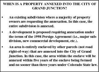
The 1998 Persigo Agreement between the City of Grand Junction and Mesa County defines how and when the City annexes new areas into the City limits generally west of the Clifton Sanitation boundary (between 31 and 32 Roads). Annexation of unincorporated areas of Mesa County into the City of Grand Junction only occurs under circumstances as described in the inset to the right.
The City and County have agreed to jointly develop incentives to encourage annexation. Examples of these incentives once they are fully developed, funded and implemented may include parks, fire stations and/or road improvements.
(Res. 13-05, 1-5-05)
37.24.040 Changes to the Future Land Use Map.
In 2003, four of the following areas (Areas 1 through 4) in the Pear Park neighborhood were identified as requiring further study for potential changes to the Future Land Use Map. The various options listed and identified as part of this planning process were derived from a focus group, an advisory committee of various service providers in the Pear Park area and City and County Staff. Area 5 is an area identified by the Bureau of Reclamation, needing a land use map change from “Park” to “Conservation.”
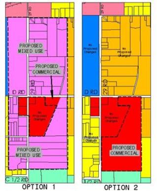
(a) Area 1. North side of D 1/2 Road between 29 and 30 Roads. The objective of Area 1 is to eliminate split land use classifications on individual properties north of D 1/2 Road between 29 Road and 30 Road. Currently, many of the properties have a Commercial/Industrial land use classification on the northern portion of the properties and a residential land use classification on the southern portion. The study area also includes other properties within this area that would be directly affected by any changes to the Future Land Use Map. A majority of the affected landowners have stated they would prefer the western portion and along D 1/2 Road in the study area be designated as residential. There were no changes considered for the northeast corner of Area 1.
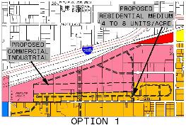
(1) Option 1 – Includes proposed residential four to eight units per acre along the north side of D 1/2 Road, with commercial/industrial north of the residential.
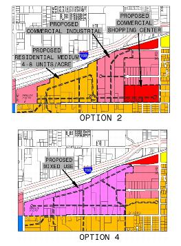
(2) Option 2 – Includes proposed residential four to eight units per acre north of D 1/2 Road and west of 29 1/2 Road and commercial/industrial east of 29 1/2 Road and north of D 1/2 Road with neighborhood commercial at the northwest corner of D 1/2 and 30 Roads.
(3) Option 3 – Includes residential four to eight units per acre west of 29 1/2 Road and south of the railroad tracks. The area east of 29 1/2 Road and north of the residential remain commercial/industrial. Option 3 is the preferred alternative and is being recommended for adoption. (See Future Land Use Changes Map at the end of this chapter.)
(4) Option 4 – Includes proposed mixed use from 29 Road to 29 3/4 Road, north of D 1/2 Road. This option would make the area mixed use, allowing for various residential and commercial uses. Standards for the mixed use category would have to be proposed and adopted through a separate rezoning process.
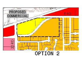
(b) Area 2. Southeast Corner of D and 29 Roads. Area 2 is being considered for additional commercial and higher density residential adjacent to the existing commercial area. The City’s Growth Plan and the Mesa Countywide Land Use Plan recommend providing for a variety of densities and housing types dispersed throughout the City and the urban area. There is currently only one small area along 32 Road and Hill Avenue that is designated higher density in Pear Park. In addition, this area would be a logical transitional area between low density residential to the east and the commercial area to the west. Creating a commercial area too large will have regional economic implications. Creating a mixed use district for this area may be difficult due to the size and shape of existing parcels. A Residential Medium-High designation (eight to 12 units per acre) would allow for Residential Office (RO) zoning to be considered. RO zoning allows small scale office uses that have strict architectural control.
(1) Option 1 – Commercial and mixed use for the entire area between C 1/2 Road and D 1/2 Road, both sides of 29 Road.
(2) Option 2 – Increase commercial designation for the area east and south of the commercial area.
(3) Option 3 – Increase density from residential medium (four to eight units per acre) to residential medium high (eight to 12 units per acre) for the area east and south of the commercial area. Option 3 is the preferred alternative and is being recommended for adoption. (See Future Land Use Changes Map at the end of this chapter for this option.)
(c) Area 3. South of E Road and east of 30 Road. The two vacant parcels at the northeast corner of E Road and 30 Road are separated from the rest of the area by major roadways and the railroad. The isolation of these two parcels and proximity to the railroad tracks makes the current land use designation of two to four dwelling units per acre (Residential Medium Low) not desirable. The three parcels on the south side of E Road are also being considered for change.
(1) Option 1 – Commercial on the northeast corner of E and 30 Roads. Option 1 is the preferred alternative and is being recommended for adoption. (See Future Land Use Changes Map at the end of this chapter for this option.)
(2) Option 2 – Increase commercial area to include both sides of E Road east of 30 Road.
(d) Area 4. South of D 1/2 Road and West of 31 Road. This neighborhood plan also examined the need for adequate neighborhood shopping areas that will serve Pear Park. Two areas were considered. The first area is located at the northwest corner of 30 Road and D 1/2 Road and the second area is at the southeast corner of 31 Road and E Road. This second area is the preferred alternative and is being recommended for adoption. (See Future Land Use Study Area Map at the end of this chapter for this option.)
(e) Area 5. The Colorado River Wildlife Area. The Colorado River Wildlife Area and the Orchard Mesa Wildlife Area are located north and south of the Colorado River between 30 and 31 Roads and immediately south of D Road (see Chapter 37.36 GJMC, Environmental Resources River Corridor). This land owned by the Bureau of Reclamation is developed and managed for the preservation of permanent wildlife habitat along the Colorado River. The majority of the property is closed to the public year-round for wildlife protection. The use on the property is “conservation,” therefore the current “Park” land use designation as shown on the Future land Use Map is not appropriate. The change to “Conservation” for the wildlife area is being recommended for adoption. (See Future Land Use Changes Map at the end of this chapter for this option.)
(Res. 13-05, 1-5-05)
37.24.050 Regional Center/Colorado Mesa University (formerly Mesa State College) property.
Colorado Mesa University (formerly Mesa State College) owns a large area of undeveloped land at the northwest corner of 29 Road and D Road. At this time there are no public plans for this site. The Grand Junction Regional Center, owned and operated by the State of Colorado, has some surplus property immediately west of the Colorado Mesa University (formerly Mesa State College) property.
(Senate Bill 11-265, 6-6-11; Res. 13-05, 1-5-05)
37.24.060 Goals.
(a) Eliminate split land use categories on individual properties along the north side of D 1/2 Road.
(b) Provide for adequate neighborhood commercial areas that will serve the Pear Park neighborhood.
(c) Establish areas of higher density to allow for a mix in housing options.
(Res. 13-05, 1-5-05)
37.24.070 Implementation strategies.
(a) Adopt the recommended Future Land Use Map changes as shown on the Future Land Use Study Area Map.
|
Area 1 |
Option 3 |
|
Area 2 |
Option 3 |
|
Area 3 |
Option 1 |
|
Area 4 |
Designate SE corner of 31 and E Roads Commercial. |
(b) Adoption of this Pear Park Neighborhood Plan amends the Future Land Use Map land use designation from “Park” to “Conservation” for the Bureau of Reclamation property preserved for the Colorado River Wildlife Area and the Orchard Mesa Wildlife Area.
(c) Based on the adoption of the Pear Park Neighborhood Plan by the Mesa County Planning Commission and the recommendation for adoption by the City Planning Commission, future study of two areas for potential changes to the Future Land Use Map shall be conducted in the first quarter of 2005 and brought back to both Planning Commissions by April/May 2005. The areas to be further studied are:
(1) Teller Court Area – located west of 30 Road.
(2) D Road Area – located south of D Road to the river, between 30 Road and 32 Road.
(Res. 13-05, 1-5-05)
37.24.080 Pear Park neighborhood special study areas, 2005 – Planning process.
The special areas planning process (see GJMC 37.24.070(c)) began in January 2005. Public input was solicited at two focus group meetings, a public open house, individual meetings with property owners upon request and written comments, phone calls, e-mail and personal communications. The public open house held February 22, 2005, was well attended by approximately 120 people. Notice of the open house was mailed to every property owner in the planning area (approximately 4,600) announcing the topic areas of discussion. On March 31, 2005, a joint City County Planning Commission public hearing was held for consideration of the special study areas adoption.
On April 20, 2005, Grand Junction City Council adopted changes to the Future Land Use Map for the two study areas as noted below (see map at the end of this chapter):
(a) Teller Court Special Study Area Future Land Use Map. Approved changes to the Future Land Use Map to reflect the following:
Changing the Future Land Use Map to Industrial for the entire parcel located at 489 30 Road and for only that area located within the study area for the following two parcels, the northern approximate half of the parcel at 2968 D 1/2 Road and the northern approximate three quarters of the parcel at 2991 Teller Court.
(b) D Road (Between 30 and 32 Roads, South Side) Special Study Area Future Land Use Map. Approved changes to the Future Land Use Map to reflect the following for subareas A, B, C, D, E and F:
(1) Subarea A. From “Estate” to “Residential Medium.”
(2) Subarea B. From “Estate” to “Residential Low” (Note: The Mesa County Planning Commission approved this area as “Residential Medium”).
(3) Subarea C. From “Estate” to “Residential Medium.”
(4) Subarea D. From “Conservation” and “Estate” to “Residential Medium-Low.”
(5) Subarea E. From “Estate” and “Park” to “Conservation.”
(6) Subarea F. From “Estate” and “Park” to “Conservation.”
(Res. 71-05, 4-20-05)