


Division 10-50.90:
Resource Protection Standards
Sections:
10-50.90.010 Purpose
10-50.90.020 Applicability
10-50.90.030 Priority for Resource Protection
10-50.90.040 Floodplains
10-50.90.050 Steep Slopes
10-50.90.060 Forest
10-50.90.061 Forest Resource Pilot Program
10-50.90.070 Resources Survey Requirements
10-50.90.080 Natural Resources Protection Plan
10-50.90.090 Resource Protection During Construction
10-50.90.100 Activities Allowed in Natural Resources Areas
10-50.90.110 Mitigation
10-50.90.120 Enforcement
10-50.90.010 Purpose
A. Purpose. This division provides standards for the protection of Natural Resources, Floodplains, steep slopes, and forest. The requirements of this division are intended to maintain Natural Resources and to promote public health, safety, and welfare by managing Development with the character of its natural surroundings. Flagstaff has a greater wildfire likelihood than many communities in the United States. Developments should be designed to advance wildfire resiliency and to coexist with native habitats and existing Natural Resources that provide important visual, environmental, health, and economic benefits. Standards in this division also protect developed places from wildfires and other natural hazards, such as floods, by integrating risk-reduction measures into a Development’s design. Division 10-30.60, Site Planning Design Standards, and Appendix 5 (Additional Information Applicable to Division 10-50.90, Resource Protection Standards) provide additional standards, guidelines, and procedures on resource protection and site design.
B. Goals. This division prescribes standards for the preservation and maintenance of Natural Resources to achieve the following goals:
1. Preserve and protect significant Natural Resources characterized by unusual terrain, unique geologic formations, and high value native vegetation before, during, and after the construction of new Development;
2. Limit encroachments into rural Floodplains;
3. Manage healthy and sustainable forests to reduce the risk of wildfires initiating urban fires;
4. Prioritize wildfire resilience to ensure neighborhoods, sites, and Buildings are designed to be better prepared for the increasing risks of urban fires initiated by wildfires;
5. Enhance air quality, reduce the amount and rate of stormwater runoff, improve stormwater runoff quality, and increase the capacity for groundwater discharge;
6. Prioritize the preservation of significant Natural Resources that maintain wildlife corridors and habitats; and
7. Enhance the natural environment, visual character, and aesthetic qualities of the City for its citizens’ and visitors’ enjoyment.
(Ord. 2025-12, Amended, 7/1/2025 (Res. 2025-32))
10-50.90.020 Applicability
A. The provisions of this division apply to proposed Development within the Resource Protection Overlay (RPO) zone. See Section 10-40.50.030, Overlay Zones, and Section 10-90.30.050, Resource Protection Overlay (RPO) Map. Any perceived conflict between the provisions of this division and any other section of this Zoning Code shall be resolved in compliance with the Zoning Code, Chapter 10-20, Administration, Procedures, and Enforcement. This division is meant to apply in conjunction with the Flagstaff Fire Department’s implementation of the Flagstaff Forest Stewardship Plan, which occurs before forest resource calculations are completed. See Appendix 5, Additional Information Applicable to Division 10-50.90, Resource Protection Standards. The Forest Stewardship Plan will continue to be applied by the Fire Department in coordination with Community Development Division staff so as not to negatively impact any future Development options.
B. Resource calculation standards for Slope, Floodplain, and Forest Resources do not apply to the area within the public rights-of-way for streets and major (i.e., regional distribution) utility facilities.
C. Appendix 5, Additional Information Applicable to Division 10-50.90, Resource Protection Standards, provides useful information on how the Flagstaff Fire Department implements Firewise principles. It also provides a summary and explanation of how to apply the resource protection standards described in this division.
(Ord. 2025-01, Amended, 2/18/2025 (Res. 2025-02); Ord. 2016-07, Amended, 2/16/2016 (Res. 2016-02))
10-50.90.030 Priority for Resource Protection
A. Purpose. The purpose of prioritizing resources is to help ensure that the requirements of this division are met and that the highest quality resources are protected as required by the General Plan while at the same time allowing for flexibility in site design. Thus, based on the unique attributes of a particular site, it should be possible to balance the needs for protection of floodplain, slope, and forest resources with an applicant’s intent to develop their property. Resource protection is applied on a parcel basis. However, the application of these standards should help maintain the overall health of the natural environment by taking into account the connection of contiguous resources and recognizing wildlife corridors.
B. Priority for Resource Protection. Natural resources and natural features shall be retained and protected in the following order of priority (listed from highest to lowest priority, starting from the top). Resources located in setback areas shall be counted towards areas protected.
1. Floodplains. Rural and urban floodplains as defined in Section 10-50.90.040, Floodplains.
2. Steep Slopes. Steep slopes as defined in Section 10-50.90.050, Steep Slopes. Steepest slopes shall be given the highest priority for protection.
3. Forest. Forest as defined in Section 10-50.90.060, Forest, shall be retained and protected on-site in the following order of priority. The Director and representatives from the Flagstaff Fire Department are available as a resource to assist in the prioritization of resources.
a. Forest areas that connect to rural and urban floodplains. Areas with the most large trees as determined in Section 10-50.90.070(D) shall be given the highest priority;
b. Forest areas that connect to steep slopes. Areas with the most large trees as determined in Section 10-50.90.070(D) shall be given the highest priority;
c. Ponderosa pines with a diameter at breast height (DBH) of 18 inches or more;
d. Forest areas that connect to large undeveloped, protected, or vegetated tracts of land within or adjacent to the site. Areas with the most large trees as determined in Section 10-50.90.070(D) shall be given the highest priority; and
e. Native trees and native tree forests (other than ponderosa pines) as determined in Section 10-50.90.070(D).
4. Other Site Features. In addition to subsection (B) of this section, when evaluating the areas most suitable for natural resource retention and protection, the City will take into account other on-site features, such as areas of geological interest and rock outcroppings.
10-50.90.040 Floodplains
A. Applicability. Floodplains, as applied in this division, shall be considered as either urban or rural floodplains as described below.
1. Urban Floodplains. All watercourses and associated floodplains not defined as rural floodplains are urban floodplains. Urban floodplains are typically located in urbanized areas and have typically been altered from their natural state by channelization. Urban floodplains may be altered to address conveyance and erosion concerns; provided, that all necessary requirements of the City’s Stormwater Regulations as administered by the Stormwater Manager are addressed. However, certain urban floodplains that have characteristics conducive to water quality, wildlife habitat, and stream ecology should be preserved. Proposals for any disturbance of these watercourses shall be reviewed by the Stormwater Manager and must address these attributes and provide for mitigation if necessary. Undergrounding of urban floodplains is strongly discouraged and a justification must be provided prior to any approval of undergrounding.
2. Rural Floodplains. Rural floodplains are natural undisturbed open spaces that are unsuitable for development purposes due to periodic flood inundation and the need to preserve the stream corridor for beneficial uses such as the preservation of important ecological resources. Rural floodplains are delineated in Section 10-90.40.030, Rural Floodplain Map, and defined as areas of delineated 100-year floodplain that cannot be disturbed or developed except for roadway and utility crossings. Rural floodplains cannot be altered through a floodplain map amendment or revision and must remain undisturbed (i.e., 100 percent protection). The extension of rural floodplains beyond the limits of the delineated floodplains, both upstream and laterally, may be required based on more current or extended floodplain studies, master plan documents or other studies or documents related to hydrology, hydraulics, stream geomorphology, wildlife habitat, or wildlife corridors.
10-50.90.050 Steep Slopes
A. Applicability. Slope is measured by taking the vertical distance, or “rise,” over the horizontal distance, or “run.” The resulting fraction, or percentage, is the “slope” of the land. Steep slopes, as applied in this division, are those areas of land that exhibit slopes of 17 percent and greater. The slope area to be protected is based on the steepness of the slope and the zone as illustrated in Table 10-50.90.050.A, Slope Protection Thresholds.
|
Slope |
Residential Zones |
Commercial, Industrial, and Public Lands Zones |
|---|---|---|
|
0 – 16.99% |
No protection; development permitted |
|
|
17% – 24.99% |
70% of slope area |
60% of slope area1 |
|
25% – 34.99% |
80% of slope area |
|
|
>35% |
No development allowed; however, these areas can be used to determine the resource area to be protected |
|
|
End Notes |
||
|
1Except for mixed-use developments with residential uses such as those within a Traditional Neighborhood Community Plan (see Division 10-30.80), where the slope protection threshold shall be 70 percent of slope area. |
||
B. Data Sources. Steep slopes shall be determined through the use of a digital terrain model (DTM) with an accuracy of plus or minus one foot. The analysis shall be performed using a computer program such as AutoCAD Civil 3D, Arc View, or equivalent and presented in a hatched or colored map. In the alternative, steep slopes may be determined manually using the methodology described in subsection (C) of this section.
C. Methodology. The following methodology may be used to identify steep slopes protected under this division if a DTM is not used. An example of the methodology is shown in Figure 10-50.90.050A.
1. Steep Slope Determination. To qualify as a steep slope, the slope must be at least 17 percent with a 10-foot vertical drop over a 100-foot horizontal distance parallel to at least one common contour line. The horizontal measurement shall cross property lines to establish if a steep slope may exist on a parcel (i.e., the 100-foot minimum width calculation shall cross a property line if necessary to achieve this minimum width).
Figure 10-50.90.050A
Steep Slope Identification Methodology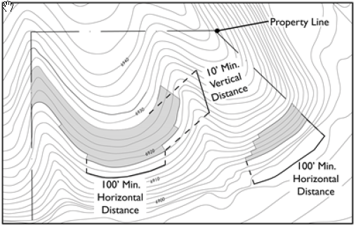
2. Area Calculation. Steep slope areas should be calculated based on the square feet of qualifying steep slope on the parcel as determined in subsection (C)(1) of this section. There is no minimum square footage for each slope area.
a. Calculate the square footage of slopes 35 percent and greater first. Determine the square footage of each area as well as the sum of the areas for the total site.
b. Calculate the square footage of slopes between 25 and 34.9 percent second. Determine the square footage of each area as well as the sum of the areas for the total site.
c. Calculate the square footage of slopes between 17 and 24.9 percent third. Determine the square footage of each area as well as the sum of the areas for the total site.
(1) Horizontal extensions of steep slopes with less than 10 feet of vertical drop shall be included in this category to calculate the area of steep slope.
(2) Areas of slope that do not qualify by themselves as steep slopes for the 25 to 34.9 percent category or the 35 percent and greater category (i.e., minimum 10 feet vertical and 100 feet horizontal distance) shall be included in this category to calculate the area of steep slope.
3. Steep Slope Resource Area. Based on the area calculations in subsection (C)(2) of this section, Table 10-50.090.050.A, Slope Protection Thresholds, shows the percentage of slope area that must be included in the resource protection area. The steep slope areas to be protected shall be included in the survey (Section 10-50.90.070(C)(2)).
4. For every 50 square feet of additional slope area that is determined to be protected over and above the minimum required in this section, then one credit point will be credited towards the minimum required forest resource calculations established in Section 10-50.90.070, Resources Survey Requirements.
(Ord. 2016-07, Amended, 2/16/2016 (Res. 2016-02))
10-50.90.060 Forest
A. Applicability. Forest, as applied in this division, includes the following:
1. Ponderosa pines and ponderosa pine forests; and
2. Native trees (other than ponderosa pines) and native tree forests, including Douglas firs, Gambel oak and associated thickets, juniper, and pinyon pine trees.
B. Methodology.
1. This section establishes a minimum forest resource protection threshold for all parcels subject to the Resource Protection Overlay (RPO). Forest resources are determined according to the resources survey requirements (Section 10-50.90.070, Resources Survey Requirements), which establish the quality and priority for forest resource protection based on a point rating system.
2. Tables 10-50.90.060.B.2.a. and 10-50.90.060.B.2.b. shall be used to determine the minimum amount of forest resources that must be retained on-site. Protection thresholds applicable to affordable housing developments are located in Division 10-30.20, Affordable Housing Incentives.
|
Table 10-50.90.060.B.2.a. Forest Resource Protection Thresholds as a Percentage of Site Area |
|||
|---|---|---|---|
|
Commercial Zones |
Industrial Zones |
Public and Open Space Zones |
Residential Zones |
|
30% |
20% |
30% |
50% |
|
Table 10-50.90.060.B.2.b. Forest Resource Protection Thresholds as a Percentage of Site Area |
||||
|---|---|---|---|---|
|
T1 Natural1 and T2 Rural1 Zones |
T3 Neighborhood1 1 and 2 Zones |
T4 Neighborhood1 1 and 2 Zones |
TNCP |
|
|
80% |
50% |
30% |
See Section 10‑50.90.060.B.5 |
|
|
End Notes |
||||
|
1. |
The percentage of forest resource protection also applies to a zone’s sub-zones. |
|||
3. The amount of forest resources required to be protected on a property may be reduced through the application of the following sections of this code:
a. Section 10-30.20.040, Affordable Housing Incentives;
b. Section 10-30.60.030.B., Solar Orientation or Aspect;
c. Section 10-30.60.090.B.1., Civic or Public Space Requirement;
d. Section 10-50.60.050.A.1., Plant Material Considerations; and
e. Section 10-50.80.060.E., Parking Reductions for Forest Resources.
4. Where forest resources on a site overlap with steep slope resources, the following standards apply:
a. For affordable housing developments, refer to the standards in Section 10-30.20.040, Affordable Housing Incentives.
b. For all other developments located within the Resource Protection Overlay, up to 25 percent of the forest resources in the steep slope area may be counted towards the required amount of forest resources for the entire site at a ratio of one credit point for forest resources to 50 square feet of slope area.
5. Minimum forest resource protection shall be the greater of:
a. Thirty percent of the gross lot, calculated as an average across the entire site; or
b. The total percentage calculated shall be based on the location and allocation of the transect zones in the Traditional Neighborhood Community Plans (TNCP) and the corresponding transect zone requirements of Table 10-50.90.060.B.2.b.
(Ord. 2019-32, Amended, 11/5/2019 (Res. 2019-49); Ord. 2016-07, Amended, 2/16/2016 (Res. 2016-02))
10-50.90.061 Forest Resource Pilot Program
A. The purpose of the Forest Resource Pilot Program (FRPP) is:
1. To allow an alternative Forest Resource preservation methodology utilizing technological innovations to inventory existing Forest Resources for both forest stewardship and preservation purposes; and
2. To implement the Flagstaff Fire Department Forest Management Plan (the "Forest Management Plan"); and
3. To determine the effectiveness of the program for future revisions to the Forest Resource protection standards in alignment with the purpose and goals of this division for all properties within the Resource Protection Overlay (RPO).
B. Program Term. Unless otherwise extended or extinguished by a separate ordinance approved by the City Council, the FRPP shall terminate at 11:59 p.m. on July 31, 2028.
C. Applicability. All properties subject to the Resource Protection Overlay both developed and vacant may participate in the FRPP. This pilot program applies only to Forest Resources and does not apply to Slope resources or other requirements of this division.
D. Forest Resource Agreement.
1. The Director shall enter into a Forest Resource agreement with the applicant to allow participation in the pilot program. The agreement shall be in a form satisfactory to the City Attorney or their designee.
2. The agreement shall be perpetual unless terminated in accordance with the provisions of this section and the agreement.
3. The agreement shall include, but is not limited to:
a. The City’s commitment to provide any existing data to assist the applicant with the preparation of forest stewardship plan and Natural Resource Protection Plan; and
b. The applicant’s responsibility to supplement available City data as determined by the Director, for the Development Site, including but not limited to information on tree height, tree density, and basal area density calculations; and
c. The applicant’s commitment to the purpose and goals of the Forest Management Plan, the purpose and goals of this division, and the priority for Forest Resource protection found in Section 10-50.90.030.B.3. except as modified in the Forest Management Plan. Failure to comply with the purposes, goals, and priorities can be cause for terminating the use of the pilot program on a Development Site; and
d. The applicant’s commitment to achieve residential densities that further the goals of the City’s 10-Year Housing Plan and Carbon Neutrality Plan; and
e. An agreement that no tree work shall occur on the Development Site prior to the review and approval of a forest stewardship plan and Natural Resources Protection Plan by City staff; and
f. Permission for City staff and their consultants to access all property affiliated with the Development Site utilizing the FRPP; and
g. Maintenance of Forest Resources before, during, and after the completion of Development; and
h. Violations and remedies; and
i. Any other provision necessary as determined by the City Attorney, Director, or their designee to document the requirements and enforcement of this section and the agreement.
4. The agreement shall be approved and executed by the Director and applicant prior to the submittal of forest stewardship and Natural Resource Protection Plans.
E. Minimum Requirements.
1. A comprehensive digital tree inventory shall be prepared for the Development Site that identifies all Forest Resources, overall tree density and basal area calculations, and high value resources for the Development Site. High value resources include the oldest, largest, and most fire-resistant trees on a Development Site. The characteristics used to make this determination vary based on the species of tree but may include height, shape, and bark. The digital tree inventory shall also identify any Slope resources that are required to be preserved subject to Section 10-50.90.050.
2. The proposed Development plan shall preserve to the greatest extent feasible high value resources, as determined by staff from the digital tree inventory and site inspections.
3. Forest Resource preservation shall align with the desired conditions of the Forest Management Plan as determined by the Flagstaff Fire Department and the Development Site is not required to meet the percentages in table 10-50.90.060.B.2.a.
4. This program does not permit the deforestation of a Development Site. Deforestation is when forests are permanently destroyed for the purposes of Development.
5. The termination of the FRPP after the execution of the Forest Resources agreement by the Director and the applicant does not impact the applicant’s eligibility to participate in the FRPP so long as Development approvals are completed within 18 months and construction has commenced on site within 24 months from the termination of the FRPP.
(Ord. 2025-12, Added, 7/1/2025 (Res. 2025-32))
10-50.90.070 Resources Survey Requirements
A. Applicability. An application for development approval that is subject to this division shall include a resources survey, in compliance with this section.
B. Qualifications of Preparer. The survey shall be prepared by an individual or individuals approved by the City with the demonstrated education, training, or experience to prepare these surveys in a professional and competent manner. Resource surveys include not only a survey of tree locations, but also include, for example, a description of the ecological value of the ponderosa pine forest. A boundary survey shall only be performed by a land surveyor registered in the State of Arizona consistent with statutory requirements for such surveys. The Director may authorize acceptance of qualified individuals to perform resource surveys upon receipt of a resume demonstrating an individual’s capabilities. The Director’s decision to accept or deny an expert shall be final.
C. Survey Contents. The resources survey shall identify natural resources as defined in this division and recommend appropriate resource protection and/or mitigation measures. The resources survey shall include the following information, if applicable:
1. Topographic maps and narrative delineating urban or rural floodplains as defined in Section 10-50.90.040, Floodplains.
2. Maps and narrative describing steep slopes as defined in Section 10-50.90.050, Steep Slopes.
3. Maps and narrative describing forest as defined in Section 10-50.90.060, Forest.
4. Description of ecological value of the ponderosa pine forest based on tree size, condition and location.
5. Identification of all ponderosa pines with a DBH of six inches or more or other native trees over 10 feet in height. These trees shall be assigned points as listed in Table 10-50.90.070.A, Point Rating System for Ponderosa Pines, and Table 10-50.90.070.B, Point Rating System for Other Native Trees. If it is determined that the tree is weak, damaged, infected or otherwise lacks vigor, the tree shall may not be assigned the number of points based on its DBH, and the survey preparer may assign fewer or no points to that tree.
6. Survey of forest resources with total points assigned based on the tree sizes listed in Table 10-50.90.070.A, Point Rating System for Ponderosa Pines, and Table 10-50.90.070.B, Point Rating System for Other Native Trees. Areas to survey shall be determined according to subsection (D) of this section.
a. Table 10-50.90.070.A, Point Rating System for Ponderosa Pines, shows the point rating system for Ponderosa pines. (The last column of this table is included for informational purposes only and is not used as part of the forest resource calculations; it is useful however, to determine permitted encroachments into forest resource areas.) See below:
|
DBH |
Points |
Average Diameter of Canopy (feet) |
|---|---|---|
|
< 6 inches |
0 points |
8 |
|
6 inches |
1 point |
8 |
|
7 inches |
1 point |
10 |
|
8 inches |
1 point |
11 |
|
9 inches |
2 points |
12 |
|
10 inches |
2 points |
14 |
|
11 inches |
2 points |
15 |
|
12 inches |
2 points |
16 |
|
13 inches |
4 points |
18 |
|
14 inches |
4 points |
19 |
|
15 inches |
4 points |
20 |
|
16 inches |
4 points |
21 |
|
17 inches |
4 points |
23 |
|
18 inches |
8 points |
24 |
|
19 inches |
8 points |
25 |
|
20 inches |
8 points |
27 |
|
21 inches |
8 points |
28 |
|
22 inches |
8 points |
29 |
|
23 inches |
8 points |
31 |
|
24 inches |
8 points |
32 |
|
> 25 inches |
20 points |
>33 |
|
Source: NAU School of Forestry for Young Growth Ponderosa Pine Trees. |
||
b. Table 10-50.90.070.B, Point Rating System for Other Native Trees, shows the point rating system for native trees (other than ponderosa pines):
|
Species |
Threshold to be Assigned Points (tree height) |
Points |
|---|---|---|
|
Douglas Firs, Gambel Oak and Oak thickets, Junipers, Pinyon Pines |
Greater than 10 feet |
8 |
7. Final determination of the forest resources to be protected is calculated by applying the forest resources protection threshold (Table 10-50.90.060.A, Forest Resource Protection Thresholds as a Percentage of Site Area) to the results of the forest survey completed in subsection (C)(6) of this section.
8. Areas of Encroachment on Forest Resources. A maximum of 20 percent of a tree’s canopy may be encroached upon (see Figure 10-50.90.070A). If more than 20 percent encroachment occurs, the tree will be considered “removed.” The 20 percent encroachment rule applies to temporary and permanent encroachments, such as construction materials storage, sidewalks and structures.
Figure 10-50.90.070A
Allowed Temporary and Permanent Encroachment on Tree Canopy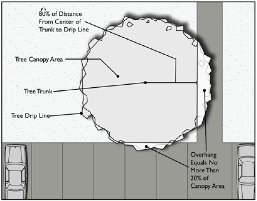
9. Determination of areas most suitable for natural resource retention and protection based on the standards of this division and the prioritization for resource protection established in Section 10-50.90.030, Priority for Resource Protection.
D. Forest Area Surveyed.
1. If a development application covers less than five acres, 100 percent of the site must be surveyed for forest resources.
2. If a development application covers five or more acres, sampling of forest resources may be employed. In selecting the sample area(s) the intent is to sample the areas most representative of forest resources on the site. At least 15 percent of the canopy area shall be sampled based on the canopy area as determined by aerial photography and field checking. Section 5.030, Summary of How to Apply Forest Resources, in Appendix 5, Additional Information Applicable to Division 10-50.90, Resource Protection Standards, includes an explanation of a sampling technique that distributes one-tenth acre circular plots uniformly across a minimum of 15 percent of the site. Alternative sampling techniques may be employed if an applicant can demonstrate to the Director’s satisfaction that the suggested technique is representative of the distribution of forest resources on the site.
10-50.90.080 Natural Resources Protection Plan.
When natural resources are retained under this division, a natural resources protection plan shall be submitted with the grading plan and shall include the following information.
A. Natural Resources Areas. The natural resources area calculated and mapped according to Section 10-50.90.070, Resources Survey Requirements, shall be included as part of the natural resources protection plan.
B. Limits of Land Disturbance, Clear-Cutting, Grading and Trenching. Layout of the on-site utility and grading plans shall accommodate the required natural resource area(s). Utilities shall be placed outside of the natural resource areas except as allowed in Sections 10-50.90.070, Resources Survey Requirements, and 10-50.90.100, Activities Allowed in Natural Resources Areas.
C. Resource Protection During Construction. See Section 10-50.90.090, Resource Protection During Construction.
D. Schedule. Documentation of procedure and schedule for the implementation, installation and maintenance of forest protection measures.
E. Permeable Surfacing. A permeable area, equal to the area encircled by the drip line, shall be provided around existing forest that will be used as landscaping to allow water absorption and growth.
F. Permit Approvals. Issuance of grading and building or other permits is contingent upon approval of a natural resources protection plan.
G. Inspection. The Director will conduct site inspections for the enforcement of natural resource protection measures. Inspections may be withheld or a stop work order or notice of violation shall be issued if a development is found to be out of compliance with the protection methods approved in the natural resources protection plan.
10-50.90.090 Resource Protection During Construction
Natural resources to be preserved on-site shall be protected before on-site land disturbance commences so as to prevent root damage, trunk damage, and soil compaction. Land disturbance includes grading, clear-cutting, trenching, and building construction. Resource protection shall consist of the following:
A. Fencing. Temporary fencing shall be installed along the outer edge of the natural resource(s) and completely surround the drip lines plus five feet of all trees or clumps of trees within 50 feet of proposed land disturbance areas. Figure 10-50.90.090A illustrates the temporary fencing requirements. The following conditions shall also apply:
1. Temporary fencing shall be polyethylene laminar safety “snow fencing” (minimum of four feet high) which is securely embedded into the ground in such a way that it cannot be easily moved or pushed over.
2. Temporary fencing shall not be attached to trees.
3. Areas within the temporary fencing shall be kept free of construction materials, vehicles, equipment and debris, except as provided in Section 10-50.90.070(C)(8).
4. Temporary fencing shall be installed prior to and maintained throughout the land disturbance process and shall not be removed until landscaping is installed or financial assurance is posted for the required landscaping.
Figure 10-50.90.090A
Tree Fencing during Construction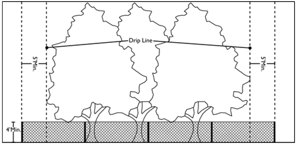
B. Tree Wells. Tree wells are required where grade changes are proposed which would affect resource preservation. Tree wells shall be constructed to ensure that no soil is added to the natural grade around and under the tree canopy. Removal of tree protection fencing to construct tree wells is subject to review and approval by the Director. Tree wells are illustrated in Figure 10-50.90.090B.
Figure 10-50.90.090B
Tree Well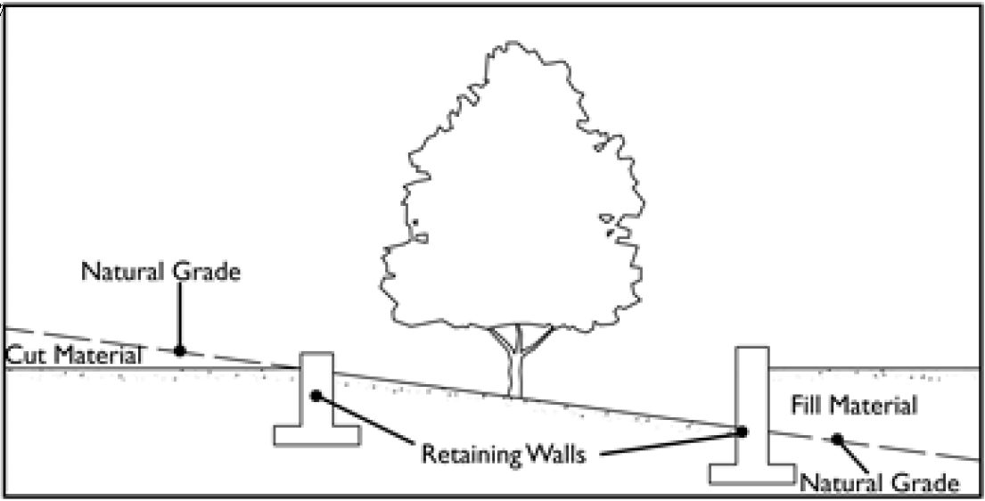
C. Construction Site Activities. Construction site activities, such as parking, material storage, concrete washout, etc., shall be arranged to prevent disturbances of natural resources. These measures also protect natural resources from silt and sedimentation.
10-50.90.100 Activities Allowed in Natural Resource Areas
Natural resource areas contain fragile natural features such as floodplains, steep slopes and forest that can be adversely impacted by development. In the RPO zone these areas must be set aside for resource protection to meet the minimum requirements of this division. Activities that are allowed in natural resource areas are shown in Table 10-50.90.100.A, Activities Allowed in Natural Resource Areas.
|
|
Floodplains |
Steep Slopes (17 to 35%) |
Forest |
|
|---|---|---|---|---|
|
Urban |
Rural |
|||
|
Agricultural Uses |
||||
|
Bee keeping |
No |
Yes |
No |
Yes |
|
Fields or pasture |
Yes |
Yes |
No |
No |
|
Livestock enclosures |
No |
No |
No |
No |
|
Nurseries |
Yes |
Yes |
No |
No |
|
Recreational |
||||
|
Active recreation |
Yes |
Yes |
No |
No |
|
Garden plots/community gardens |
Yes |
Yes |
No |
Yes |
|
Passive recreation |
Yes |
Yes |
Yes |
Yes |
|
Picnic area |
Yes |
Yes |
No |
Yes |
|
Other |
||||
|
Drainage |
Yes |
Yes |
No |
Yes |
|
Landscape buffer (see Division 10-50.60, Landscaping Standards) |
Yes |
Yes |
Yes |
Yes |
|
Utilities (includes service lines) |
Yes |
Yes |
Yes |
Yes |
(Ord. 2016-07, Amended, 2/16/2016 (Res. 2016-02))
10-50.90.110 Mitigation
Where meeting the standards in this division results in scattered building sites, areas that are too small to be reasonably used, or other design problems that cannot be resolved by revised site layouts, the Director or the Planning Commission may apply the following mitigations. However, in no case shall the provisions in this section apply to rural floodplains.
A. Director. The Director may allow modifications up to five percent of the natural resources areas to be protected. In such case, the Director may require mitigation that complies with subsection (B)(2) of this section.
B. Planning Commission. The Planning Commission may allow modifications to development projects for which it has review authority that comply with subsections (B)(2) and (B)(3) of this section, of up to 10 percent of the resource protection standards as follows:
1. If retention of natural resources cannot be maintained, the resources survey must demonstrate:
a. Why priority areas described in Section 10-50.90.030, Priority for Resource Protection, cannot be retained;
b. That there are no reasonable methods or techniques to implement the resource protection requirements of this division;
c. A proposal for mitigation as defined in this section; and
d. Mitigation proposals should not create future fire problems and have been approved by the FFD.
2. On-Site Mitigation.
a. On-site forest shall be replaced at a three to one ratio with additional irrigated landscaping of a number, type and size that meets the intent of this division. The species of plants used in mitigation shall be similar to those destroyed.
b. For on-site mitigation of one acre or greater, a mix of trees, shrubs and plants is appropriate. Table 10-50.90.110.A, On-Site Mitigation, provides a guide for the number of trees and plants per acre.
|
4 native evergreen trees, minimum 6-foot height |
|
8 native deciduous trees, minimum 2.5-inch caliper |
|
80 native evergreen trees, minimum 4-foot height |
|
20 other trees, 10-gallon evergreen or deciduous |
|
Disturbed areas should be seeded with native grass and/or wildflower mix |
3. Off-Site Mitigation. In situations where the natural resources of a parcel are located in the only feasible area for development, an applicant may mitigate the impacts according to the following requirements.
a. Planting of one and one-third acres of new forest off-site, or preserving one acre of existing forest in areas designated by the City for preservation and enhancement. Off-site planting may only be used when the applicant or the City owns or controls the site(s);
b. The species of plants used in mitigation shall be similar to those destroyed. Table 10-50.90.110.A, On-Site Mitigation, provides a guide for the number of trees and plants per acre;
c. The applicant shall provide financial assurances indicating that all plant material that dies within three years shall be replaced with similar material containing a similar guarantee period;
d. A temporary irrigation system approved by the Director shall be installed in all planted areas; and
e. The land on which the mitigation is to take place shall be permanently preserved and deed restricted with a protective easement or the property deeded by fee title to the City in a form approved by the City Attorney and accepted by the Council.
4. When evaluating the mitigation of natural resources, the Planning Commission may require extraordinary development practices including the tunneling of utilities, placing all utilities under the street, stepping or spanning foundations, pumping concrete, using small equipment to minimize site disturbance or hand digging, and leaving exposed rock in place as part of the overall site design.
10-50.90.120 Enforcement
A. Any individual, corporation, association or other entity violating any provision of this division shall, upon conviction thereof, be punishable by a fine not exceeding $1,000 per offense. The cutting down or destruction of each tree shall constitute a separate offense.
B. If trees identified as forest resources are cut down, destroyed, intentionally damaged or removed for any reason, in conjunction with any land use, development, or soil movement activity in excess of the specified number of trees that were approved for removal by City issued permit, a stop work order shall be issued (refer to Section 10-20.110.090, Enforcement by Stop Work Order), and restitution shall be made by the applicant in accordance with the schedule in Table 10-50.90.110.A, Tree Replacement, and replaced if they die within the first three growing seasons.
|
Diameter of Tree Removed (Inches DBH) |
Number of 2 1/2-Inch Caliper Trees to Be Planted |
OR number of 4-Inch Caliper Trees to Be Planted |
Fines for Illegal Tree Removal (per Tree) |
|---|---|---|---|
|
6 to 12 |
4 |
2 |
$1,000 |
|
13 to 17 |
6 |
3 |
$2,000 |
|
18 to 24 |
8 |
5 |
$5,000 |
|
25 and over |
15 |
8 |
$10,000 |
C. In cases where such tree removal or clearing by the landowner occurs prior to meeting the standards of this division, the natural resource calculations and locations shall be determined by the Director utilizing the most suitable photographs available, taken prior to the removal, and other reliable data.