


Article 7 / Subdivision and Land Split Standards
Sec. 7.1 / Applicability
All plats and the layout, design and engineering of all subdivision improvements within the City of Prescott shall conform to the General Development Standards of Section 6, the City of Prescott General Engineering Standards and to the following rules and regulations.
Sec. 7.2 / Purpose
The subdivision of land is a major factor in the process of sound community growth and ultimately becomes a public responsibility in that the streets must be maintained and various public services customary to urban areas must be provided. The welfare of the entire community is thereby affected in many important respects. Therefore, it is to the interest of the public, to the developer, and to the future owners that subdivisions be conceived, designed, and developed in accordance with sound rules and proper minimum standards. To these ends, it is critical that new subdivision development be coordinated between City departments and public agencies, including but not limited to: Community Development, Public Works, and the Fire Department. It is the intent of these regulations to encourage the growth of the City of Prescott in an orderly manner.
Sec. 7.3 / Building Lots
7.3.1. / Creation of Building Site
No permit for the construction of a building or buildings upon any tract or plot shall be issued until a building site, building tract, or building lot has been created by compliance with one of the following conditions:
A. The lot or tract is part of a plat of record, properly approved by the legislative body and recorded in the records of Yavapai County Recorder; constructed and released by the appropriate jurisdiction;
B. The lot or tract is part of a record of survey (metes and bounds parcel) or land split, properly approved by the Community Development and Public Works Departments and recorded in the records of Yavapai County Recorder, in which event a Building Permit(s) may be issued for uses conforming to all the requirements of this Code; or
C. The parcel, tract or lot fronts upon an approved street and is a “lot of record” in which event a Building Permit(s) may be issued for uses and structures conforming to all the requirements of this Code. Nonconforming lots of record are also subject to the provisions of Sec. 10.4, Nonconforming Lots of Record.
Where an area is proposed to be divided into lots more than twice the size of the zoning district minimum lot area and any or all of the tracts are susceptible of being resubdivided, the proposed subdivision shall be such that the alignment of future street dedications may conform to the general street layout in the surrounding area and so that the larger tracts may be later subdivided in conformance with the requirements of this Code and the minimum standards specified by the zoning district.
Sec. 7.4 / Subdivision and Land Split Design Standards
A. Community Assets
In all subdivisions, due regard shall be shown for all natural features such as trees and other vegetation, watercourses, boulder outcroppings, historical sites and similar community assets, which, when preserved, will add attractiveness and value to the property.
B. Suitability of Lands
The Community Development Director shall not approve the subdivision of land if, from adequate investigations conducted by all public agencies concerned, it has been determined that in the best interest of the public, the site is not suitable for platting and development purposes of the kind proposed. Land subject to flooding, land in proximity to the airport approach, and land deemed to be topographically unsuitable should not be platted for residential occupancy, or for such other uses as may increase danger to health, life, or property, aggravate erosion or flood hazard. Such land within the plat shall be set aside for uses that are not endangered by periodic or occasional inundation or that produce unsatisfactory living conditions.
C. Reserved Strips Prohibited
There shall be no reserved strips or easements controlling access to land or streets dedicated or intended to be dedicated to the public, except as may be required by a public agency for access management purposes.
D. Waivers
The Community Development Director and Public Works Director may grant waivers to the standards of this Section 7.4, Subdivision and Land Split Design Standards, with the exception of the City of Prescott General Engineering Standards, where it finds that such waivers are necessary due to the physical characteristics of the site, is not harmful to surrounding properties or public interests, and is consistent with Section 1.5, Purpose and Intent, of this Code.
7.4.2. / Engineering and Construction Standards
A. All streets, alleys or easements shall be designed and constructed in accordance with the City of Prescott General Engineering Standards and Standard Details, and in particular regard for the street regulations of Sec. 7.4.3, Streets.
B. All streets, water, sewer and drainage facilities shall be designed by a licensed engineer registered in the State of Arizona. Such facilities shall be constructed to and through the property in question, and stubbed at the farthest property boundary possible to facilitate future extension.
C. Where City of Prescott General Engineering Standards referenced herein or otherwise promulgated by the City do not specifically cover a design or construction issue, the Public Works Director or City Engineer may enforce other recognized industry standards, including but not limited to, those indicated in the City of Prescott General Engineering Standards, Article 1.
A. Street Layout
Adequate streets shall be provided by the subdivider such that the arrangement, character, extent, width and grade of each shall conform to the General Plan, transportation plans and specific area plans, and shall be considered in their relation to existing and planned streets, to the topographical conditions, to the public safety and convenience and to their appropriate relationship to the proposed use of the land to be served by such streets.
B. Relation to Adjoining Street Systems
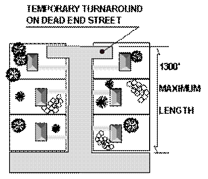
Where beneficial to the neighborhood pattern, existing streets in adjacent or adjoining areas shall be continued in the new development, and in alignment therewith. Whenever connections to anticipated or proposed surrounding streets are required by this section, the right- of-way shall be extended and the street developed to the property line of the subdivided property (or to the edge of the remaining undeveloped portion of a single tract) at the point where the connection to the anticipated or proposed street is expected. The City may also require a temporary turn-around to be constructed at the end of such streets pending their extension when such turn-around appears to facilitate the flow of traffic or accommodate emergency or service vehicles.
C. Dead-End Streets
Dead-end streets shall be prohibited except short stubs to permit extension. Temporary turnarounds shall be required where the street stub exceeds one lot or 100 feet in length. The developer shall provide a sign at the stub declaring that the particular street shall connect with any future development. No temporary dead-end street in excess of 1,300 feet may be created. 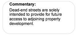
D. Cul-de-Sacs
Cul-de-sacs shall not exceed 1300 feet in length to the beginning of the cul-de-sac radius, and shall terminate in a turnaround with a minimum right-of-way radius of 50 feet, and with a minimum outside edge-of-pavement radius of 40 feet. The City may require shorter cul-de-sac lengths based on a consideration of public safety factors, including but not limited to density, slopes, street capacity and fuel load. No cul-de-sac in excess of 1,300 feet may be created.
E. Street Jogs
Street jogs with centerline offsets of less than 200 feet shall be avoided.
F. Half Streets
No half streets shall be platted or constructed. Where improvements are required for two adjacent subdivisions, the first subdivision shall complete all required improvements, with not less than 24’ of pavement.
G. Arterial and Collector Streets on General Plan, Transportation Plans or Specific Area Plans
1. Where a subdivision embraces a recommended street as shown on the General Plan, transportation plans or specific area plans, such street shall be platted to maintain continuity in the approximate location as shown, and of the type indicated.
2. In certain cases, the City may have constructed a street through the area to be subdivided, in which case subdividers shall develop the necessary street intersection at their expense, in accordance with the requirements of this section.
3. Residential lots proposed adjacent to arterial and collector streets shall be platted or restricted so as to prevent driveways opening into such streets.
H. Local Streets
1. Local streets shall be planned and designed to continue and connect to surrounding areas as the terrain permits to foster dispersion and connectivity. Traffic calming devices may be required to slow traffic on local streets. The minimum pavement surface widths are defined in the City of Prescott General Engineering Standards and are based on street classification.
2. Four-way intersections shall be avoided in residential developments where sight distance or other such constraints exist.
I. Alleys
1. Alleys may be required at the rear of all lots whether intended to be used for business or residential purposes.
2. Alleys shall generally be parallel to the street, and shall be not less than 20 feet wide constructed with a minimum structural section of 3 inches asphaltic concrete (AC) over 6 inches aggregate base course (ABC).
3. No dead-end alleys shall be permitted.
4. Alleys shall have a minimum 20-foot right-of-way; provided, however, where overhead electric and/or communication lines occur the minimum right-of-way shall be 25 feet.
J. Plats of Dedication
Plats of dedication are the preferred method of land description and conveyance where public streets or easements are created. A plat of dedication may be required by the City.
K. Private Streets
Private streets, where applicable, shall be declared on the Preliminary Plat and designated on the Final Plat and shall meet or exceed City standards for design and construction. All private streets shall be privately maintained. Where pavement width is less than 28 feet, on-street parking shall be prohibited on both sides.
L. Geometric Standards, Street Design Standards
Streets shall be designed in accordance with City of Prescott General Engineering Standards and Standard Details, which are summarized in Table 7.4.3.L, Street Design Standards.
|
STREET DESIGN STANDARDS |
||||||
|---|---|---|---|---|---|---|
|
CRITERIA |
LOCAL STREETS |
COLLECTORS |
ARTERIALS |
|||
|
Street Classification (See COP Detail for more info) |
Rural Local Residential (COP Detail 601P) |
Local Residential (COP Detail 602P) |
Residential Collector (COP Detail 603P) |
Commercial/ Industrial Collector (COP Detail 604P) |
Minor Arterial (COP Detail 605P) |
Major Arterial (COP Detail 606P) |
|
Minimum Right-of-Way |
50 ft. |
50 ft. |
60 ft. |
70 ft. |
100 ft. |
120 ft. |
|
Curb Type |
No Curb |
4" or 6" Rolled adjacent to lots, 6" Vertical adjacent to common areas |
4" or 6" Rolled adjacent to lots, 6" Vertical adjacent to common areas |
Vertical |
Vertical |
Vertical |
|
Maximum Grade |
12% |
12% |
8% |
8% |
6% |
6% |
|
Minimum Curve Radius |
135 ft. |
205 ft. |
320 ft. |
450 ft. |
600 ft. |
1000 ft. |
|
Bicycle Facilities |
Within Travel Lanes |
Within Travel Lanes |
Within Travel Lanes |
Designated 4’ Bike Lane |
Combined Bike/Pedestrian Trail |
Combined Bike/Pedestrian Trail |
|
Curb Return Minimum Radius |
25’ Pavement Radius |
25’ |
30 ft. |
30 ft. |
Determined by TIA |
Determined by TIA |
|
Minimum Pavement Structural Sections * |
3" AC over 6" ABC |
4" AC over 6" ABC |
4" AC over 6" ABC |
5" AC over 8" ABC |
6" AC over 10" ABC |
6" AC over 10" ABC |
|
Design Speed |
25 mph |
30 mph |
35 mph |
40 mph |
50 mph |
55 mph |
|
Posted Speed |
25 mph |
25 mph |
25-30 mph |
30-35 mph |
35-45 mph |
45 mph |
|
Commercial Entrance Curb Return Min. Radius |
N/A |
N/A |
N/A |
30’ min. or to accommodate the largest typical vehicle |
30’ min. or to accommodate the largest typical vehicle |
30’ min. or to accommodate the largest typical vehicle |
|
Driveway Type |
Wing-Type Driveway (COP Detail 250Q) |
Wing-Type Driveway (COP Detail 250Q) |
Wing-Type Driveway (COP Detail 250Q) |
Return-Type Driveway (COP Detail 251Q) |
Return-Type Driveway (COP Detail 251Q) |
Return-Type Driveway (COP Detail 251Q) |
|
# of Driveways per Frontage |
1 typical, 2 max. if circle driveway on a lot with 100’ min. frontage |
1 typical, 2 max. if circle driveway on a lot with 100’ min. frontage |
1 typical, 2 max. if circle driveway on a lot with 100’ min. frontage |
3 max. depending on length of frontage** |
3 max. depending on length of frontage** |
3 max. depending on length of frontage** |
|
Driveway Spacing |
10’ min. between D/Ws and 80’ min. from intersection |
10’ min. between D/Ws and 50’ min. from curb return |
10’ min. between D/Ws and 50’ min. from curb return |
200’ min. |
200’ min. |
300’ min. |
|
Driveway Width |
12’ min. to 24’ max. |
12’ min. to 24’ max. |
12’ min. to 24’ max. |
16’ min. to 30’ max.** |
16’ min. to 40’ max.** |
16’ min. to 40’ max.** |
|
* The pavement structural sections shown here are design minimums. A geotechnical analysis and pavement structure design report must be submitted to the City for review and approval. |
||||||
|
** Per approved Site Plan. |
||||||
New streets shall be named so as to provide continuity of existing streets, and to prevent conflict with identical or similar names in other parts of the City as determined by the Fire Department.
A. Blocks
1. Blocks generally shall be platted to provide 2 tiers of lots with a utility easement or alley as needed, with proper regard for drainage channels, wooded areas and other topographical features lending themselves to sensitive treatment.
2. Block length shall not exceed 1,200 feet in single-family residential areas and shall not exceed 800 feet in multi-family or non-residential areas.
3. In blocks over 800 feet in length and at the end of cul-de-sacs that abut an existing or future school, park, trail, bikeway or street, there shall be provided an accessway as defined in Sec. 7.4.6C, Bikeways and Multi-use Paths. 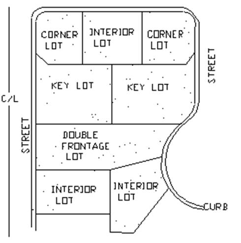
B. Lots
1. Side lot lines that make acute angles with front lines shall be avoided where practical. In general, an arrangement placing adjacent lots at right angles, and creating key lots to each other, shall be avoided.
2. Lots abutting accessways shall be treated as corner lots.
3. Lot size and setback lines shall be in accordance with zoning requirements. Corner lots may require a larger lot area in order to create an adequate building envelope given setback requirements.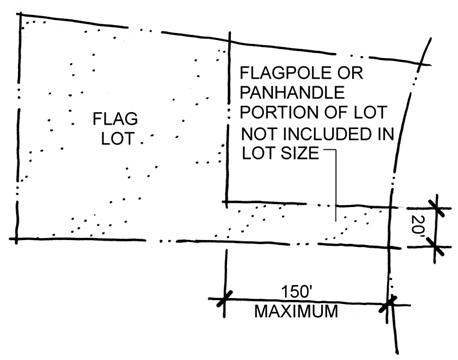
4. Flag Lots
Notwithstanding other provisions of this Code to the contrary, flag shaped or panhandle shaped lots may be created in any zone if all of the following requirements are met (Refer also to Sec. 2.7.2D2.b):
a. The lot has at least 20 feet of frontage on a dedicated public or private street, which frontage serves as access only to the subject lot or parcel;
b. The flagpole or panhandle portion of the lot shall be at least 20 feet in width;
c. The length of the flagpole or panhandle shall not exceed 150 feet as measured from the adjacent public or private street unless acceptable safety alternatives are provided. The Community Development
Director shall consult the Fire Department prior to approving such alternatives.
d. The flagpole or panhandle portion of the lot shall not be included in calculating lot size; and
e. Flag lots may not be further subdivided following initial subdivision approval.
7.4.6. / Pedestrian and Biking Facilities
A. General
The purpose of these standards is to promote the design of an urban environment that is built to human scale, to provide for the safe movement of pedestrians and bicyclists, to promote the more efficient utilization of public infrastructure, and to foster attractive street fronts and pedestrian environments, while accommodating vehicular movement and alternate transportation modes with bicycle and pedestrian access. To these ends, bicycle and pedestrian facilities designed in accordance with American Association of State Highway and Transportation Officials (AASHTO) standards and the requirements of this Section shall be included in site and subdivision master planning and designed to reduce conflicts between motor vehicles and pedestrians or bicyclists.
B. Sidewalks
1. Required
a. Unobstructed sidewalks shall be required on both sides of commercial/industrial collector and all arterial streets having a right-of-way width equal to or greater than 70 feet.
b. An unobstructed sidewalk shall be required on one side of local residential and residential collector streets. A sidewalk may be required on cul-de-sac streets if needed to provide through-pedestrian access to existing or future schools, parks, streets or recreational/ open space areas.
c. Sidewalks shall be placed within the right-of-way.
d. Where parking is permitted on one side of a street with rolled curb, the sidewalk shall be placed on the “no parking” side of the street.
e. All intersections and sidewalk terminations shall provide A.D.A. compliant pedestrian ramps.
f. All sidewalks shall be installed per the City of Prescott General Engineering Standards and Standard Details.
C. Bikeways and Multi-Use Path
Bikeways and multi-use paths shall be provided as follows:
1. Types of Bikeways and Multi-Use Paths
a. Multi-Use Paths
A facility completely separated from motorized traffic, which may be located within sole and separate right-of-way or within a standard street right-of-way. Multi-use paths accommodate both biking and walking and are therefore wider in accordance with the requirements of Sec. 7.4.6.C.2, Easements/Treadways, to improve safety.
b. Bike Lanes
A facility where both sides of the roadway or shoulder are striped, signed, and marked for exclusive or preferential bicycle use and where vehicle parking is not permitted, unless otherwise specified. The minimum bike lane width shall be 4 feet
c. Bike Routes
A facility designated by signing to help make motorists aware of the presence of bicycles, which share the right-of-way with motor vehicles.
2. Easements/ Treadways
Multi-use paths, where required for bicycle and pedestrian uses, shall have a minimum 15-foot wide public right-of-way or easement dedicated to the public with a 12 foot wide treadway constructed in the center.
3. Bikeway Location Criteria
Bikeways shall be located to integrate with the existing and future City street and park system. Important criteria used in determining facility types and locations follow below.
a. As detailed in adopted plans and policies;
b. Safety in terms of existing street width;
c. Existing and potential demand for use;
d. Continuity and directness;
e. Spacing in relation to other bikeway facilities;
f. Location of schools and other public facilities frequented by bicycle riders; and
g. Location of linear parks and greenbelts.
D. Timing of Dedication/Construction
All sidewalks, bikeways and multi-use facilities (including trails), as may be required by this Code, the General Plan or other adopted plans, or as may be negotiated through the platting process, shall be dedicated and constructed prior to release of financial assurances and/or issuance of certificates of occupancy.
E. Waiver
Waiver or partial waiver of the requirements of this section may be granted by the Community Development Director in consultation with the Traffic Engineer where it has determined that satisfactory alternative pedestrian and/or bikeways have been or will be provided outside the normal right-of-way or, that unique circumstances or unusual topographic, vegetative, or other natural or man-made conditions prevail to the extent that strict adherence to said requirements would be unreasonable and inconsistent with the purposes and goals of this Code or the General Plan.
A. Illustrated on Plat
All easements required below shall be denoted on the final plat sheet with the approved lot layout.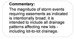
B. Drainage Easements
Where a subdivision is traversed by a watercourse or drainageway, there shall be required a drainage easement conforming substantially to the limits of such watercourse, plus additional width to accommodate future needs as determined by the City Engineer. Additional drainage easements shall be required where needed to handle lot-to-lot drainage. No construction shall impede, constrict or block the flow of water in any easement or natural watercourse. No fencing shall be allowed within a drainage easement, except along the boundary of such easement, approximately parallel to the anticipated flow. Where so designated on the plat, drainage easements may be used for utilities and for required landscaping, provided utilities and landscaping do not conflict with the drainage function or purpose for the easement.
1. Maintenance
On-going maintenance of all drainageways and drainage easements is the responsibility of the individual property owners or homeowners association where appropriate. (Sec. 7.8.5)
C. Utility Easements
1. Each block that does not locate all utilities within a right-of-way or alley as provided in Sec. 7.4.3I, Alleys, shall have a public utility easement placed along the frontage or at the rear of all lots, reserved for the use of all utility lines, conduit and equipment, as follows:
a. Utility easements containing one City-owned utility shall be 20 feet in width, 10 feet from the centerline of the pipe.
b. Utility easements containing 2 City-owned utilities shall be 30 feet in width, 15 feet from the center of where both pipes are located.
c. The required width of utility easements having a longitudinal slope of 10% or more shall be increased by 10 feet.
d. Utility easements shall be continuous for the entire length of a block and located as closely as possible to the street line frontage of the block.
2. All utility easements that contain City-owned utilities shall start and end at public rights-of-ways.
3. No cut or fill shall be allowed on a public utility easement containing a City-owned utility without written permission of the City Engineer.
4. Standard curb sections shall be required where utility easements intersect streets.
5. Where utility easements are not themselves straight within each block, or if the same do not connect on a straight course with utility easements of adjoining blocks, then an additional easement shall be provided for the placement of guy wires on lot division lines in order to support poles set on curving or deviating rights-of-way or easements.
6. Upon recommendation of the Public Works Director or his designee utility easements may be required across parts of lots other than as described above. Where the proposed subdivision adjoins an unplatted area, the full width of easement may be required along the rear of lots adjoining the unplatted area.
7. Utility easements containing water lines, but not sewer lines, may be fenced if unlocked gates with a minimum width of 16 feet are provided to allow free movement of excavating machines, maintenance equipment, and personnel throughout the full length of the easement. Fences shall be prohibited within easements containing sanitary sewer.
A. Water facilities for all development shall comply with City Code and the City of Prescott General Engineering Standards and Standard Details.
B. All subdivisions shall provide adequate water supply and distribution systems for fire protection and domestic use.
C. Public fire hydrants shall be installed as a part of the water distribution system.
D. The water supply shall be protected with a City approved backflow preventer device at each residential or commercial use as defined in City Code 2-1-55 or the City of Prescott General Engineering Standards. The device shall be located as close to the water meter as possible and boxed above ground from freeze protection that meets the requirements of the Public Works Director.
E. All water meters shall be located to provide clear access, with no landscape material, plant, debris, etc., extending above the top of the meter box in a 5-foot radius as measured from the center of the box. Meters and boxes shall be constructed in accordance with City Code, Title 2, Chapter 2-1.
F. Assured Water Supply
1. No preliminary subdivision plat shall be approved unless it is in accord with the duly adopted Prescott Water Budget and accompanied by:
a. An Assured Water Supply from the City of Prescott or a certificate of Assurance from the Arizona Department of Water Resources; or
b. Providing the City with a volume of water that is calculated by the number of lots in the proposed subdivision times 150 gpcd times the average dwelling occupancy [based upon the latest census]. Said water source shall meet the assured water supply requirements for: a) physical, legal and continuous availability; and b) water quality; and c) consistency with the City’s most current management goals.
2. The subdivider shall note on the face of the Final Plat that a certificate of assured water supply has been submitted with the plat or that the subdivider has obtained a written commitment of water service for the proposed subdivision from a City or private water company designated as having an assured water supply, pursuant to ARS 45-576 or is exempt from the requirement pursuant to ARS 45-576.
G. The City Council may enter into an agreement with a subdivider to afford an alternative water source to meet Assured Water Supply requirements only where Council finds that a proposed project or development is consistent with and conforms to, furthers the implementation of, and is not contrary to the:
1. The City’s Water Management Policy; and
2. The General Plan and other applicable plans, including but not limited to Specific Area Plans, Circulation Plans, Capital Improvement Plans, Open Space and Trail Plans, Neighborhood Plans, Local Historic District Plans, growth management or growth management plans, and redevelopment plans.
A. Sanitary sewer facilities for all development shall comply with City Code and the City of Prescott General Engineering Standards and Standard Details.
B. All subdivision sewerage systems shall be permitted and approved by the Arizona State Department of Environmental Quality or designee.
A. Drainage facilities for all development shall comply with City Code and the City of Prescott General Engineering Standards and Standard Details.
B. Drainage shall be perpetuated in natural stream channels insofar as practical. No construction shall impede, constrict, or block the flow of water in any natural or improved watercourse.
C. All easements for channels and drainage facilities shall be designated on the subdivision plat, and shall be maintained by the individual lot owner within the subdivision or by a Homeowners Association (HOA) or Property Owners Association (POA).
All utility lines that pass under streets or alleys shall be installed before the street or alley is paved, with embedment, backfill, and depths in accordance with the City of Prescott General Engineering Standards and Standard Details or the crossing shall be bored.
A. Street light facilities for all development shall comply with City Code and the City of Prescott General Engineering Standards and Standard Details.
B. All light fixtures shall utilize cut-off luminaries and otherwise be designed in accordance with the requirements of Sec. 6.11, Outdoor Lighting.
C. The developer shall furnish satisfactory easements for the installation of services to streetlights, as approved by the appropriate utility.
7.4.13. / Underground Utilities
All utilities shall be installed underground, except transformers, switching boxes, and terminal boxes.
7.4.14. / Monuments and Corner Markers (Also refer to Sec. 9.10.10)
A. All angle points, points of curvature, and corners of boundary lines of subdivisions shall be marked as specified in City of Prescott Standard Detail 120Q-Type “C”.
B. Where, due to topographic conditions, permanent structures or other conditions, the view is obstructed between any two adjacent monuments, intermediate monuments shall be set so as to assure intervisibility between adjacent monuments.
C. Lot corner monuments shall be set at corners of all lots as specified in the Arizona Board of Technical Registration Boundary Survey Minimum Standards.
D. Street monuments shall be marked with a monument as specified in City of Prescott Standard Detail 120Q.
7.4.15. / Grading and Hillside Development
Grading, erosion control, and final bank stabilization shall be required as specified in Sec. 6.7, Site Disturbance, Erosion and Grading Standards and the City of Prescott General Engineering Standards. Subdivisions proposed on slopes in excess of 20 percent shall be developed in accordance with Sec. 6.8, Hillside Development Standards.
7.4.16. / Ownership of Improvements
Upon completion by the subdivider, and acceptance by the City, streets, alleys, sidewalks, parks, drainage facilities, municipal utilities and other required public improvements shall become the property of the City of Prescott, Arizona.
Sec. 7.5 / Public Land Dedication
Public land shall be dedicated as a part of each subdivision in accordance with the City of Prescott General Plan, or any applicable open space plan, trails plan, or specific area plan.
Sec. 7.6 / Subdivision and Land Split Improvement Guarantees
Prior to recording of the final plat and prior to commencement of construction within 1 year following approval of Final Plat and construction plans unless a different time frame is approved by the Public Works Director, the subdivider shall post a financial assurance in accordance with the General Engineering Standards, Section 1.4 to cover to the cost of installing all required improvements.
7.6.2. / Release of Financial Assurances
Release or partial release of the financial assurance may occur as incremental progress is demonstrated to the satisfaction of the Public Works Director. Final release of the financial assurance shall be in accordance with the General Engineering Standards, Section 1.4.
Sec. 7.7 / Responsibility for Payment for Installation and Maintenance Costs
The subdivider shall pay the cost of all infrastructure required to support the proposed development. These items shall include, but not be limited to:
A. Setting of survey monuments and markers;
B. Streets and road construction including earthwork, base, grading, curbs, gutters, sidewalks, pavement, street name signs, street regulatory signs, culverts, and bridges;
C. Water and sewer main, lines, and service installations including on and off-site infrastructure needed to support the development;
D. Stormwater system and/or other drainage improvements;
E. Field density and related testing of base, sub-base and other compacted backfill, gradation tests, concrete cylinder tests, asphalt tests, and/or other related tests required to insure minimum standard requirements;
F. Street lighting;
G. Traffic signals, where warranted; and
H. Electric, gas, and other utilities.
7.7.2. / Oversize Participation
The City may request that an applicant increase the size of utility line capacity for the benefit of future or existing, off-site development. In such circumstances, the City shall negotiate the terms of the upsizing for the added expense, or establish a reimbursement agreement or district.
7.7.3. / Installation and Maintenance of Street Lights
The developer shall pay the entire cost of the subdivision street light installation, including the cost of service lines to supply electricity to the street lights, and all engineering design costs. Once satisfactorily installed, approved, and accepted, the maintenance of the street lights shall be provided by the City or by the homeowners’ association where the streets are private.
7.7.4. / Engineering Inspection and Tests
A. The City will charge a fee for engineering inspection services during construction and for final inspection. The subdivider shall contract with the design engineer to conduct adequate inspections to facilitate certification that the project was built according to approved plans.
B. The City may require compaction tests on embankments and flexible bases, and depth tests on flexible bases and pavements, and pressure tests on piping systems, before final inspection and approval. Charges for such inspection shall be paid for by the subdivider.
A. Prior to release of the subdivision by the City, a payment of $200 per lot shall be made to the City for each lot within the subdivision being released.
Sec. 7.8 / Mandatory Homeowners’ Associations
When a residential subdivision contains any physical facilities, structures, improvements, systems, subdivision entryway treatments or feature areas or grounds held in common and necessary or desirable for the welfare of the area or subdivision, or that are of common use or benefit and that are not or cannot be satisfactorily maintained by the City, individual homeowners or another public agency, the City may require the establishment and creation of a mandatory homeowners’ association to assume and be responsible for the continuous and perpetual operation, maintenance and supervision of such facilities, structures, improvements, systems, areas or grounds.
If the establishment and creation of a mandatory homeowners’ association is required by the City, a copy of the agreements, covenants and restrictions establishing and creating the association must be approved by the City Attorney and City Council prior to the approval of the Final Plat of the subdivision and must be filed in the records of the Yavapai County Recorder. Said Final Plat shall clearly identify all facilities, structures, improvements, systems, areas or grounds that are to be operated, maintained and/or supervised by said association.
If the City requires a mandatory homeowners’ association, the agreements, covenants and restrictions establishing and creating such mandatory homeowners’ associations shall contain or provide that the association shall be responsible for the continuous and perpetual operation, maintenance and/or supervision of landscape systems, features or elements located in parkways, common areas, between screening walls or living screens and adjacent curbs or street pavement edges, and within drainage easements, drainage structures, or at subdivision entryways.
7.8.4. / Dedications to Association
All facilities, structures, improvements, systems, areas or grounds that are to be operated, maintained and/or supervised by a mandatory homeowners’ association, other than those located in public easements or right-of-ways, shall be dedicated by easement or deeded in fee simple ownership interest to said association. Such easements and ownership shall be clearly identified on the Final Plat of the applicable subdivision.
Sec. 7.9 / Land Splits
The following referenced sections of this article shall refer to all Land Splits unless waived by the Community Development Director:
A. Building Lots, Sec. 7.3.1C;
B. Suitability of Lands, Sec. 7.4.1B;
C. Reserved Strips Prohibited, Sec. 7.4.1C;
D. Engineering and Construction Standards, Sec. 7.4.2B and Sec. 7.4.2C;
E. Plats of Dedication, Sec. 7.4.3J;
F. Lots, Sec. 7.4.5B;
G. Pedestrian and Biking Facilities, Sec. 7.4.6;
H. Easements, Sec. 7.4.7;
I. Water Supply, Sec. 7.4.8;
J. Sanitary Sewers, Sec. 7.4.9;
K. Drainage, Sec. 7.4.10;
L. Utility Lines, Sec. 7.4.11;
M. Street Lights, Sec. 7.4.12;
N. Underground Utilities, Sec. 7.4.13;
O. Grading and Hillside Development, Sec. 7.4.15;
P. Ownership of Improvements, Sec. 7.4.16;
Q. Public Land Dedication, Sec. 7.5;
R. Subdivision/Land Split Improvement Guarantees, Sec. 7.6; and
S. Responsibility for Payment for Installation Costs, Sec. 7.7.