


Article 9 / Administration and Procedures
Sec. 9.1 / Common Procedure
9.1.1 / Conformity with Land Development Code
Every official and employee of the City of Prescott vested with the duty or authority to issue a permit or license shall not issue a permit or license for any use, building, or purpose that conflicts with any provision of this Code. Any permit, license or certificate issued in conflict with the provisions of this Code may be voided at the option of the City.
9.1.2 / Pre-application Meeting
Prior to the submission of an application required by this Code, a pre-application meeting may be required as follows:
A. Mandatory Conference
Unless waived by the Community Development Director, a pre-application meeting to discuss procedures, standards, or regulations shall be required for all proposed:
1. Conditional Use Permits;
2. Nonresidential and multi-family developments;
3. Planned Area Developments;
4. Site Plan Review;
5. Special Use Permits;
6. Subdivisions;
7. Variances; and
8. Zoning Map Amendments (Rezoning).
B. Optional Conference
A pre-application meeting is optional for all other applications. Applicants are encouraged to attend an optional pre-application meeting prior to submitting any application.
9.1.3 / Application Forms and Fees
The following regulations shall apply to all applications:
A. Property Owner Identification and Endorsement
All applications shall include the name and signature of the current property owner and agent, as applicable.
B. Forms and Content
1. Applications required under this Code shall be submitted on forms, with any requested information and attachments, and in such numbers, as required by the City, including any checklists for submittals.
2. City staff shall provide a specific list of minimum submittal requirements for each application type. All applications shall meet the minimum submittal requirements and include sufficient information to demonstrate compliance with all applicable standards of this Code.
3. Should additional information be necessary to clarify or facilitate the review of an application, the Community Development Director may request any other pertinent information required to ensure compliance with this Code.
C. Fees
1. Filing fees shall be established from time to time by the City; and
2. All required fees shall be made payable to “The City of Prescott”; and
3. Applicants who pay the appropriate application fee for the submission of an application and subsequently choose to withdraw such application prior to the City expending time in review shall be entitled to a refund of 50 percent of the total amount paid upon written request; and
4. City initiated actions shall not cause a fee to be levied.
All applications shall be completed and submitted to the Community Development Director in accordance with a schedule established annually by the City. An application shall not be considered as officially submitted until it has been determined to be complete in accordance with Section 9.15.
9.1.5 / Application Completeness
An application shall be considered submitted only after the Community Development Director determines that it is complete, provided in the required form, includes all mandatory information and exhibits, and is accompanied by the applicable fee. The official responsible for accepting the application shall make a determination of application completeness within 15 working days of the submittal deadline. If an application is determined to be incomplete, the official responsible for accepting the application shall contact the applicant to explain the application’s deficiencies. No further processing of the application shall occur until the deficiencies are corrected. If the deficiencies are not corrected by the applicant within 30 days, the application shall be considered withdrawn.
9.1.6 / Area / Neighborhood Meetings
At the discretion of the Community Development Director, an “area neighborhood” meeting may be scheduled and held on any/all development related applications.
All public meetings and hearings shall be posted in City Hall in accordance with State Law and the requirements of the Prescott City Code.
9.1.8 / Posting of Public Meetings and Hearings
A. Summary of Notice Practices
Notice shall be provided as required by Title IX, Arizona Revised Statutes. Additional supplemental notices by the City of Prescott may occur as per the Community Development Director. Required and supplemental notice practices are shown in the table that directly follows.
|
SUMMARY OF NOTICE PRACTICES |
|||
|---|---|---|---|
|
Application Type |
Published |
Mailed |
(Property) Posted |
|
Administrative Adjustments |
|
X |
|
|
Appeal of Code Interpretations |
X |
|
|
|
Conditional Use Permit |
X |
X |
X |
|
General Plan Amendments |
X |
|
|
|
Historic Designation |
X |
X |
X |
|
Special Use Permit |
X |
X |
X |
|
Text Amendment |
X |
|
|
|
Variance |
X |
X |
X |
|
Zoning Map Amendment |
X |
X |
X |
B. Specific Notice Requirements
The following specific notice requirements shall apply to all required public hearings, except as may be otherwise specified in the Prescott City Code or in Arizona Revised Statutes.
1. Published Notice
An advertisement (Public Hearing Notice) shall be placed by the Community Development Director at least once in a local newspaper of general circulation within the City. The advertisement shall be published at least 15 calendar days prior to the meeting.
2. Mailed Notice
A notice of public hearing shall generally be sent by U.S. first class mail to owners of record of real property within 300 feet of the parcel under consideration or farther at the Community Development Director’s discretion. Alternatives to this standard may occur for administrative waivers, historic preservation actions, or as otherwise permitted by state statutes.
3. Posted Notice
A notice of public hearing shall be posted where legible from at least 2 rights-of-way adjoining the subject property. Such notice shall be composed of weatherproof materials.
C. Content of Notice
All published, posted, or mailed notices shall provide some, or all, of the following specific information as determined by the Community Development Director:
1. General location of land that is the subject of the application;
2. County Tax Assessor’s Parcel Number, and the street address, if available;
3. Vicinity map;
4. Substance of the application, including the magnitude of proposed development and the current zoning district;
5. Time, date and location of the public hearing;
6. Phone number to contact the City; and
7. Statement that interested parties may appear at the public hearing.
All public hearings before decision-making bodies in the City of Prescott are normally, but not always, preceded by a public meeting(s) before the same body at which the issues relative to each land use application are explored.
9.1.10 / Required Public-Hearings
The following table illustrates the types of review and the body responsible for holding a public meeting to consider such applications.
|
ITEMS FOR PUBLIC MEETINGS |
|||
|---|---|---|---|
|
Application Type |
Board of Adjustment |
Planning and Zoning Commission |
City Council |
|
Administrative Appeals |
X |
|
|
|
Comprehensive Sign Plan |
|
X |
X |
|
Conditional Use Permit |
X |
|
|
|
General Plan Amendments |
|
X |
X |
|
PAD Master Plan/Site Plan |
|
X |
X |
|
Site Plans, Council-approved |
|
X |
X |
|
Special Use Permit |
|
X |
X |
|
Subdivisions/ PAD |
|
X |
X |
|
Text Amendment |
|
X |
X |
|
Variance |
X |
|
|
|
Water Service Agreement (4 or more dwellings) |
|
|
X |
|
Zoning Map Amendment |
|
X |
X |
9.1.11 / Required Public Meetings
A. The Community Development Director shall provide notice of public hearings or public meetings to persons who annually register, by providing their names and addresses and paying the fee established by the City to cover annual expenses, as being interested in receiving such notice, and when deemed warranted.
B. The Community Development Director may require, at his discretion, applicants not otherwise required by state statutes or Code requirements to post or mail notices, and/or to attend area neighborhood meetings with surrounding residents when deemed warranted. Public meetings shall be scheduled whenever practicable prior to the public hearing.
9.1.12 / Simultaneous Processing of Applications
Whenever two or more forms of review and approval are required under this Code, the applications for those development approvals may be processed simultaneously at the option of the Community Development Director and with the approval of the applicant; provided, however, rezoning applications may not be processed simultaneous with General Plan Amendments. The simultaneous processing of applications shall be in all cases at the applicant’s risk.
Sec. 9.2 / Building Permit and Certificate of Occupancy
A certificate of occupancy shall be required for any of the following:
A. Occupancy and use of a building hereafter erected or enlarged; and
B. Change in use of an existing building to a different Use Category as set forth in Sec. 11.1.
In accordance with Prescott City Code Title III and VI, the Building Official holds the authority to issue building permits that meet the International Building Codes (IBC), City of Prescott General Engineering Standards (GES) and other applicable provisions of this Code. The Building Official is also vested with authority to approve certificates of occupancy for projects completed in accordance with approved plans consistent with the requirements of the adopted City Codes.
9.2.3 / Certificate of Occupancy Application Process
A. Application Submittal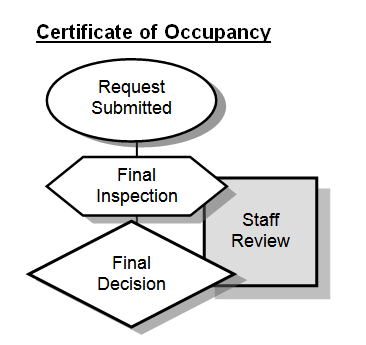
When the contractor believes a structure or use is ready for occupancy, a final inspection for a certificate of occupancy shall be requested of the Building Official or his designee.
B. Community Development Director Action
The Community Development Director or his designee shall review all certificate of occupancy requests to determine if intended uses, buildings or structures comply with all applicable Code regulations and standards, and to the approved building and site plan.
C. Building Official Action
Upon request for final inspection for a certificate of occupancy, the Building Official or his designee shall inspect the use or structure. If the Building Official determines that the use or structure complies with all applicable provisions of the building code, the City of Prescott General Engineering Standards and this Code, a certificate of occupancy shall be issued.
9.2.4 / Temporary Certificate of Occupancy
Pending the issuance of a permanent certificate of occupancy, a temporary certificate of occupancy may be issued. The temporary certificate of occupancy shall be valid for a period established by the Building Official and the Community Development Director, pending completion of improvements, or during partial occupancy of a structure. Bonding at 125 percent of the estimated improvement costs may be required for outstanding improvements.
9.2.5 / Unlawful to Occupy without Valid Certificate of Occupancy
It is unlawful to occupy any building that does not have a valid certificate of occupancy or temporary certificate of occupancy except in those instances where a building was constructed or occupied prior to the provisions of Sec. 9.2 becoming effective (Refer to Sec. 9.2.1 / Applicability.)
Sec. 9.3 / Conditional Use Permits
Conditional uses are uses that are generally compatible or can be made compatible with other uses in the underlying zoning district. Such uses may be permitted on a conditional basis under which additional requirements must be met, including determination of adequate land area and site plan approval by the planning agency. Because of their unusual characteristics or the special characteristics of the area in which they are to be located, conditional uses require special consideration so that they may be properly located with respect to the objectives of this Code and their effect on surrounding properties.
Conditional uses may be complimentary to those uses permitted by right in a zoning district, but require individual review of their location, design, configuration, and intensity, and may require the imposition of additional conditions in order to ensure the appropriateness and compatibility of the use at a particular location.
9.3.3 / Conditional Use Application Process
A. Pre-application Conference
Prior to the submission of an application for a Conditional Use Permit, all potential applicants shall meet with the Community Development Department Staff in a pre-application conference unless waived by the Community Development Director. The purpose of the conference is to respond to any questions that the applicant or the City may have regarding the application.
B. Application Submittal 
A complete application for a Conditional Use Permit shall be submitted to the Community Development Director as set forth in Sec. 9.1.3. through 9.1.5. A complete site plan must accompany all applications for a Conditional Use Permit as set forth in Sec. 9.8.4B.
C. Public Notification
Upon receipt of a complete application, as set forth in Sec. 9.1.5, public notices shall be issued in accordance with Sec. 9.1.9, Public Notices. Additional notice may also be provided to parties having specific interest in the application, or if applicable an appeal of same in accordance with the provisions of Sec. 9.1.12, Additional Notice.
D. Review by the Technical Review Committee
Following submittal of a complete application, the TRC shall review the application and provide written comments to the applicant within 15 working days.
E. Review by Community Development Director
The Community Development Director shall review Conditional Use Permit applications, the comments of the Technical Review Committee (TRC) and prepare a staff report.
F. Board of Adjustment Action
The Board of Adjustment shall review Conditional Use Permit applications in a public meeting and thereafter vote to approve, approve with conditions, or deny the application.
G. Notice of Decision
A copy of an approved or denied Conditional Use Permit shall be given to the owner of the property, and a copy shall be filed in the office of the Community Development Director.
All Conditional Use Permits shall run with the land. The Board may elect to specify a period of abandonment after which the Conditional Use Permit shall be voided.
9.3.5 / Conditional Use Review Criteria
The Board of Adjustment may approve an application for a conditional use where it reasonably determines that there will be no significant negative impact upon residents or other owners of surrounding property or upon the public. The Board of Adjustment shall consider the following criteria in its review and approval shall be contingent upon compliance with the site plan and any conditions of approval:
A. Effect on Environment
The location, size, design, and operation characteristics of the proposed use shall not be detrimental to the health, welfare, and safety of the surrounding neighborhood or its occupants, nor be substantially or permanently injurious to neighboring property.
B. Compatible with Surrounding Area
The proposed site plan, circulation plan, and schematic architectural designs shall be harmonious with the character of the surrounding area with respect to landscaping, scale, lot coverage, and the like.
C. External Impacts Minimized
The proposed use shall not have negative impacts on existing uses in the area and in the City through the creation of noise, glare, fumes, dust, smoke, vibration, fire hazard, or other injurious or noxious impact. The applicant shall provide adequate mitigation responses to these impacts.
D. Infrastructure Impacts Minimized
The proposed use shall not have negative impacts on existing uses in the area and in the City through impacts on public infrastructure such as roads, parking facilities and water and sewer systems, and on public services such as police and fire protection and solid waste collection, and the ability of existing infrastructure and services to provide services adequately.
E. Consistent with General Plan and Code
The proposed use will be consistent with the purposes of this Code, the General Plan, Area Plans, and any other statutes, ordinances or policies that may be applicable, and will support rather than interfere with the uses permitted outright in the zone in which it is located. If the use is permitted outright in another zone, there must be substantial reason for locating the use in an area where it is only conditionally allowed.
F. Parcel Size
The proposed use may be required to have additional land area, in excess of the minimum lot area otherwise required by the underlying zoning district, as necessary to ensure adequate mitigation of impacts on surrounding land uses and the affected zoning district.
G. Site Plan
The proposed use shall comply with the procedures and requirements of Sec. 9.8, Site Plan Review.
The Board of Adjustment may impose additional reasonable conditions to carry out the spirit and intent of this Code and to mitigate adverse effects of the proposed use. These requirements may include, but are not limited to, increased open space, loading and parking requirements, additional landscaping or buffering, and additional improvements such as curbing and sidewalks.
9.3.7 / Expiration/Revocation of Approval
A. Conditional Uses are granted from the date of the Board of Adjustment’s action unless otherwise modified by the Board. If construction of the project has not been completed within the first 12 months following Board approval, the Board may grant an extension for the next review for completeness of the Conditional Use Permit. Notice that the Conditional Use may expire within 12 months if construction is not completed shall be conveyed to the applicant in writing as part of the notification of approval of the permit.
B. The Board of Adjustment may extend the Conditional Use Permit upon written request from the applicant, providing the request is received before the date of expiration.
C. The Board of Adjustment may revoke a Conditional Use Permit in the event of a subsequent failure by the property owner or person in possession to comply with an on-going condition of approval. Such revocation shall not occur without written notice to the property owner, at least 20 calendar days prior, advising of the revocation consideration and an opportunity to appear before the Board. Revocation procedures shall be subject to the Public Notice requirements set forth in Sec 9.1.8A.
An appeal from any final decision regarding a Conditional Use Permit shall be in accordance with Sec. 9.18, Appeal of Council or Board of Adjustment Decisions.
Sec. 9.4 / Floodplain Encroachment Permit
In accordance with the Prescott City Code, Title XIII, a Floodplain Encroachment Permit shall be obtained before construction or development begins within any area of special flood hazard. Application for a Floodplain Encroachment Permit shall be submitted to the Floodplain Administrator of the Public Works Department.

Sec. 9.5 / Planned Area Development (PAD)
The purpose of a PAD is to permit flexibility and to provide performance criteria that can result in Planned Area Developments (PAD) which produce:
A. A range of options in the type of environment for working and living available to the public;
B. Open space and recreation areas;
C. A pattern of development which preserves trees, outstanding natural topography and geologic features, and prevents soil erosion;
D. A creative approach to the use of land and related physical development, such as lot sizes, lot coverage, flexible building height, buffer yards, and greater or lesser setbacks;
E. An efficient use of land resulting in smaller networks of utilities and streets, thereby lowering development costs;
F. Clustered development;
G. An environment of stable character in harmony with surrounding development; and
H. A more desirable environment than would be possible through strict application of other Sections or districts in this Code.
The Planned Area Development (PAD) regulates the development that integrates related uses into a single project such as office parks, commercial or service centers, shopping centers, industrial uses, or residential developments. PAD also includes proposals where appropriate combinations of uses may be planned, developed, or operated as integral land use units either by a single owner or by a combination of owners. A PAD may be used to permit new or innovative concepts in land development that the zoning district(s) does not easily accommodate. While greater flexibility is given to allow special conditions or restrictions that would not otherwise allow the development to occur, procedures are established to ensure against misuse of increased flexibility. The approval of a PAD is by the City Council’s sole discretion.
9.5.3 / Planned Area Development Application Process
A. Pre-application Meeting
Prior to the submission of an application for a PAD Preliminary Plat or PAD site plan or master plan, all potential applicants shall attend a pre-application meeting with the Community Development Director as set forth in Sec. 9.1.2, Pre-application Meeting. The purpose of the meeting is to respond to any questions that the applicant may have regarding the application.
B. Application Submittal
A complete application for a Planned Area Development, including Preliminary Plat site plan or master plan, shall be submitted to the Community Development Director as set forth in Sec. 9.1.3 through Sec. 9.1.5. A master plan may be required by the Community Development Director for relatively large, complex projects. The Preliminary Plat or master plan and associated application shall illustrate the following:
1. Proposed uses and residential types and densities;
2. General building and parking location(s), access, landscaping, topographic conditions, building heights and screening proposal;
3. Compatibility with the character of the surrounding area;
4. Conformity with the policies, goals and objectives of the General Plan, including all applicable elements;
5. No adverse affect on adjacent development;
6. Every dwelling unit has access to a public street directly or via a court, accessway or other public area or common area owned by a homeowners association, but need not front on a public street;
7. Provisions for parking spaces for all uses as set forth in this Code. Alternative parking standards as allowed pursuant to the provisions of Sec. 6.2.10 may be allowed where the applicant provides evidence showing an alternative that is acceptable to the City;
8. Provision of adequate water supply and sewer service;
9. Provision of adequate and effective drainage; and
10. Provision of adequate public improvements, including but not limited to parks, schools and other public facilities.
C. Review by Planning and Zoning Commission
The Planning and Zoning Commission shall review the proposed PAD in a public meeting and recommend approval, approval with conditions, or denial of the application.
D. City Council Action
The City Council shall review the proposed PAD in a public meeting and approve, approve with conditions, or deny the application.
The approval of a PAD designation shall include any specific conditions of approval that are imposed by the City Council, which may include site plan approval pursuant to Sec. 9.8.4F, City Council Action. Approved development plans shall be referenced as attachments. Any bulk or dimensional variations approved by City Council shall either be listed in general terms in the certified approval or shown on the referenced attachments. Unless otherwise specified in writing, all development shall be subject to the requirements of the underlying zoning district.
9.5.5 / Official Zoning Map Reference
All Planned Area Developments approved in accordance with the provisions of this Code shall be parenthetically referenced on the Official Zoning Map. A list of such Planned Area Developments, together with the category of uses permitted therein, and other related attached plan or plat shall be maintained in the Community Development Department.
9.5.6 / Effect of an Approved Master Plan
An approved master plan shall be binding on current and future property owners. All site plans shall be in substantial conformance with the approved master plan.
The Planning and Zoning Commission shall review and the City Council may approve a Planned Area Development based on the following criteria:
A. Conforms with applicable regulations and standards established by this Code, unless a deviation therefrom is allowed in the PAD process;
B. Is compatible with existing or permitted uses on abutting sites or with uses internal to the PAD, in terms of use, building height, bulk and scale, density, setbacks and open spaces, landscaping, drainage, access and circulation features, or other elements within the standards established by the City;
C. Does not create unfavorable effects or impacts on other existing uses in the area or potential permitted uses in the area that cannot be mitigated by the provisions of the City;
D. Does not affect the safety and convenience of vehicular and pedestrian circulation in the vicinity;
E. Reasonably protects persons and property from erosion, flood or water damage, fire, lighting, noise, glare, and similar hazards or impacts;
F. Generally complies with the policies adopted in the General Plan of the City of Prescott.
Unless otherwise indicated in the approved master plan, by development agreement, or as modified by Sec. 9.5.11, Density Transfers and Maximum PAD Density, the minimum requirements for each development shall be those stated in this Code based on the underlying base zoning district. Modification of these density and dimensional standards may be considered during the approval process of the PAD, provided measures are taken to provide effective mitigation of potential negative impacts.
9.5.9 / PAD Development Standards
PAD approvals may specify greater or lesser development standards than required by the underlying zoning district. Greater flexibility may be warranted where citywide goals are met, and where there is sufficient capacity, on site and off site, to accommodate impacts and provide for appropriate mitigation.
A. Hillsides
PAD developments located on slopes greater than 20 percent shall be subject to the standards and processes found in Sec. 6.8, Hillside Development Standards. Where Table 9.5.11 and Sec. 6.8 are in conflict, the more restrictive shall apply. Generally, steep slopes are appropriate for open space preservation.
B. Minimum Lot Area
Minimum lot area may be reduced to achieve the maximum density specified by the underlying zoning district, subject to adequate site area and infrastructure, overall functionality, and open space requirements.
C. Open Space
A minimum of 25 percent of the entire PAD property shall be dedicated or reserved as private common or public open space (qualifying open space). All improvements proposed within qualifying open space shall be indicated on the master plan and related plans or plats approved by Council. Such qualifying open space shall be protected by no-build easements or plat designation where appropriate, as a condition of PAD approval. The City may request qualifying open space to be rezoned to the RS district or NOS district, as appropriate.
1. Qualifying open space may include undisturbed land and drainages, natural wildlife habitat areas, non-motorized trails, hillsides, golf courses and cart paths, ball fields and tennis courts, swimming pools, clubhouses, restaurants, pro-shops and similar commercial-like uses, and medians at least 8 feet in width within dedicated public right-of-way that are landscaped in accordance with Sec. 6.5.5, Minimum Landscape Standards. However, qualified open spaces that entail impervious improvements shall not constitute more than 20 percent of the required open space (5 percent of the total PAD).
2. Qualifying open space shall not include streets, alleys or rights-of-way (public or private) vehicular drives, concrete-lined drainages, parking lots, storage areas, or loading and unloading areas.
3. Common buffer yards may qualify as open space; however, private yard area designed or intended for the sole use and enjoyment of the resident lot owner shall not qualify as open space for PAD requirements.
4. Maintenance shall be as established during the approval of a qualifying PAD project.
D. Lot Coverage
Maximum permitted lot coverage shall be that of the underlying zoning district except where a minimum of 40 percent of open space is provided, the lot coverage shall not be limited.
E. Streets and Parking
As provided in Sec. 6.2, Off-street Parking and Loading; Sec. 7.4.3, Streets, and Sec. 6.3, Access Management, lesser street widths, tandem arrangement for required single-family residential parking, and gated private streets may be approved, based upon impeding natural or manmade constraints, and demonstrated adequate or enhanced supplemental parking and general circulation for project users and the general public.
F. Setbacks
Garage or carport setbacks shall be a minimum of 20 feet from the right-of-way or 22 feet from the back of adjacent curb or sidewalk, and sufficient to accommodate off-street parking out of the right-of-way. Setbacks for other front, side or rear yards may be varied where overall function and compatibility are retained.
G. Building Heights
As specified in the underlying zoning district; however, Council may adjust permitted building heights up or down, based upon concept plan and consideration of any off-site impacts.
H. Residential Protection
As specified in Sec. 6.13, Residential Protection Standards, additional buffer yard depths and/or treatments may be required along PAD project perimeters and internal boundaries within PAD developments, as may be approved by the City Council.
I. Land Uses
All land uses shall conform to those permitted in the underlying zoning district; provided however, density transfers as described in Sec. 9.5.11, may be developed in clustered groupings of attached or detached dwellings provided that each unit in a clustered grouping is located on its own individual lot. Townhouses, patio homes and similar housing products on individual lots may be developed within a clustered grouping. However, the density transfer provisions of Sec. 9.5.11 shall not be interpreted to allow Multi-family Dwellings on individual lots in single-family districts.
J. Landscaping
Where required, a preliminary landscape plan shall be included with a PAD concept plan or Preliminary Plat and shall show dimensions, existing vegetation and topographic contours, and any proposed added plantings or walls. A final landscape plan shall be required prior to final site plan or Final Plat approvals.
9.5.10 / Exceptions to PAD Development Standards
Exceptions to otherwise required minimum PAD standards, including but not limited to open space, lot coverage, setbacks, parking and maneuvering, may be approved by the City Council. Examples of projects that might be eligible for such exceptions include but are not limited to small in-fill projects; existing apartments converting to condominiums and projects exhibiting high quality designs and buffering that adequately meet the PAD objectives. Such exceptions shall not be approved where the exception adversely affects the surrounding neighborhood.
9.5.11 / Density Transfers and Maximum PAD Density
Density transfers within a residential or mixed-use PAD may be permitted for the clustering of units consistent with the requirements of Sec. 9.5.9I, Land Uses, in areas suitable for development, thus preserving open space and natural features. Where more than one zoning district occurs within a PAD, the maximum number of dwelling units within the PAD shall be determined by totaling the allowable residential density for each respective zoning district as follows:
|
MAXIMUM PAD DENSITY |
||
|---|---|---|
|
Zoning District |
Maximum Gross Residential Density Via PAD (Density Factor) |
Maximum Residential Densities When Transferring Densities to Adjacent, More Restrictive Zoning District |
|
RE-2 District |
0.5 unit per gross acre |
0.5 unit per gross acre |
|
SF-35 District |
1.1 units per gross acre |
1.1 unit per gross acre |
|
SF-18 District |
2.2 units per gross acre |
2.2 unit per gross acre |
|
SF-12 District |
3.3 units per gross acre |
3.3 unit per gross acre |
|
SF-9 District |
4.4 units per gross acre |
4.4 units per gross acre |
|
SF-6 District |
6.6 units per gross acre |
6.6 unit per gross acre |
|
RT District |
12 units per gross acre |
6 unit per gross acre |
|
MF-M District |
21 units per gross acre |
11 unit per gross acre |
|
MF-H District |
32 units per gross acre |
16 unit per gross acre |
|
MU District |
10 units per gross acre |
5 unit per gross acre |
|
RO District |
10 units per gross acre |
5 unit per gross acre |
|
NOB District |
14 units per gross acre |
7 unit per gross acre |
|
BG District |
32 units per gross acre |
16 unit per gross acre |
|
BR District |
32 units per gross acre |
16 unit per gross acre |
|
DTB District |
N/A |
N/A |
|
IT District |
14 units per gross acre |
7 units per gross acre |
A. The above maximum allowable PAD densities may be reduced to ensure compatibility with surrounding existing neighborhood densities and sustainability with regard to natural resources, particularly water availability.
B. Where multi-family or nonresidential district zoning is combined with adjacent single-family zoning, maximum allowed densities shall be reduced by up to 50% as indicated in the above table. (See also Sec. 9.5.9I, for additional related requirements.)
C. Any single or combined BR, BG or IT District PAD shall be processed as a rezoning in accordance with the requirements of Sec. 9.15, Zoning Map Amendments.
9.5.12 / Compliance with Other Regulations
The granting of a PAD designation shall not relieve the developer from responsibility for complying with all other applicable Sections of this Code and other codes and ordinances of the City of Prescott, unless such relief is granted in the approved concept plan or plat.
9.5.13 / Homeowners’ Association Required
A homeowners’ association will be required if other satisfactory arrangements have not been made for providing, operating, and maintaining common facilities including streets, drives, service and parking areas, common open spaces, buffer areas and common recreational areas at the time the development plan is submitted. If an owners association is required, it shall be submitted to the City to assure compliance with the provisions Sec. 7.8, Homeowners Associations.
9.5.14 / Council-approved Modifications
All changes of use from those approved in the original PAD, and any deviations from the approved concept plan not authorized by Sec. 9.5.15, below, shall require City Council approval.
9.5.15 / Administrative Changes to PAD Concept Plan
All changes of use from those approved in the original PAD shall require City Council approval. Minor additions and administrative changes to the approved Development Plans meeting the criteria below may be approved by the Community Development Director:
A. Minor additions to structures, with a gross floor area no larger than 10 percent of the approved gross floor area of the main floor, not to exceed 5,000 square feet; or minor new accessory structures if the location does not interfere with existing site layout (e.g. circulation, parking, loading, storm water management facilities, open space, landscaping or buffering);
B. Minor additions to parking lots comprising no more than 25 percent of the original number of parking spaces required, not to exceed 25 spaces; or
C. Clearing or grading that does not exceed 5,000 square feet in area or 50 cubic yards.
9.5.16 / Expiration of Approval
The concept plan or master plan shall expire if development has not begun within 24 months of the effective date of the PAD approval, unless an extension is granted by the City Council.
An appeal from any final decision regarding a Planned Area Development shall be in accordance with Sec. 9.17, Appeals of Administrative Decisions or Sec. 9.18, Appeal of Council or Board of Adjustment Decisions, as appropriate.
Sec. 9.6 / Site Disturbance and Grading Permit
A site disturbance and grading permit shall be required as specified in Sec. Sec. 6.7, Site Disturbance, Restoration and Grading Standards.
The City Engineer holds the authority to issue site disturbance and grading permits consistent with the City of Prescott General Engineering Standards and the provisions of this Code.
9.6.3 / Site Disturbance and Grading Permit Application Process
A. Application Submittal
Applications for a site disturbance and grading permit shall be submitted to the Community Development Department. Such applications shall be made by an Arizona-registered civil engineer or other qualified registrant, and shall contain information to demonstrate compliance with all conditions for the proposed site disturbance, grading, erosion control, and restoration as set forth in Sec. 6.7, Site Disturbance, Grading and Restoration and the City of Prescott General Engineering Standards. At a minimum, such applications shall include a copy of either the approved Preliminary Plat or a Preliminary Site Development Plan approved by the Community Development Director illustrating the following:
1. Public street access points;
2. Parking locations;
3. Adequate cut and fill (scarring) mitigation where applicable;
4. Building footprint(s) suitable for a permitted use and consistent with applicable size and setback requirements of this LDC;
5. Landscape areas and soil retaining treatments, if applicable;
6. Erosion controls and/or a stormwater pollution prevention plan (SWPPP), as applicable;
7. Drainage analysis and calculations demonstrating pre- and post-development flows, and detention requirements; and
8. Other information as may be required by the City Engineer or Community Development Director.
B. City Engineer Action
The City Engineer shall review the application in consultation with the Community Development Director to ensure compliance with all applicable code requirements and approve, approve with conditions, or deny the application.
9.6.4 / Site Disturbance and Grading Permit Criteria
All site disturbance and grading permit applications shall be reviewed for conformance with the requirements of Sec. 6.7, Site Disturbance, Grading and Restoration and the City of Prescott General Engineering Standards.
An appeal from any final decision regarding a grading permit shall be in accordance with the City of Prescott General Engineering Standards, Article 9, Alterations and Modifications.
Sec. 9.7 / Sign Permits and Comprehensive Sign Plans
A sign permit is required prior to the installation, relocation, expansion, or structural alteration (including any change to a sign face) of any sign. All sign permits are issued by the Community Development Director in conformity with the provisions of this Code. (See sign standards in Sec. 6.12, Signs)
The following sign types are exempt from the provisions of this section:
A. Real estate (“for sale” or “for lease”), finance, and construction signs;
B. Traffic control signs; and
C. Governmental signs.
9.7.3 / Sign Permit Application Process
A. Application Submittal
A complete application for a sign permit or Comprehensive Sign Plan shall be submitted to the Community Development Director as set forth in Sec. 9.1.3, Application Forms and Fees, above. All sign permit applications shall provide information regarding location, materials, size, color and illumination. Sign permit applications shall be also required as part of a final site plan or final plat submittal, as may be required by the Community Development Director.
B. Community Development Director Action
The Community Development Director shall review each sign permit application for compliance with the requirements of this Code and act to approve, approve with conditions, or deny the permit.
C. Appeal
An appeal from any final decision regarding a Sign Permit shall in accordance with Sec. 9.17, Appeals of Administrative Decisions.
9.7.4 / Comprehensive Sign Plans
A. Applicability
A Comprehensive Sign Plan may be requested for qualifying properties as described in Sec. 6.12.6, Comprehensive Sign Plan Standards.
B. Compliance
All owners, tenants, subtenants and purchasers of individual units within the development shall comply with the approved Comprehensive Sign Plan.
C. Application Requirements
1. The proposed plan shall include the size, location, height, color, lettering, lighting, and orientation of all proposed signs, in addition to any other information deemed necessary.
2. Allowances for a Comprehensive Sign Plan shall be subject to the stipulations and conditions specified by the City Council through the approval process. Implementation of a Comprehensive Sign Plan may be completed in phases.
D. Review by Planning and Zoning Commission
The Planning and Zoning Commission shall review the application in a public meeting and recommend approval, approval with modifications, or denial of the subject application.
E. City Council Action
The City Council shall review the application in a public meeting and approve, approve with modifications, or deny the application.
F. Comprehensive Sign Plan Review Criteria
A Comprehensive Sign Plan may be approved by the City Council when it finds that the plan meets the objective of an improved design in exchange for a greater number of signs or larger sign face area than otherwise permitted by Sec. 6.12, Signs.
9.7.5 / Maintenance and Repair
Cleaning, painting, repainting and other normal maintenance and repair of a sign shall not require a sign permit unless a structural or size change is made. Maintenance does not include replacement of a sign face.
Sec. 9.8 / Site Plan Review
The provisions of this section are intended to ensure that all developments have functional, well-designed and user-oriented spatial arrangements. Where Council approval is required, there may be greater emphasis on aesthetic quality.
No building, site, or use shall be developed and no building permits may be issued prior to completion of site plan review and approval, issued by the Community Development Director in conformity with the provisions of this Section. In addition, where required, site plan approval by City Council and/or the Planning and Zoning Commission may be required as a prerequisite for building permits.
Although single-family residences must have an approved site plan for a building permit, individual single-family dwellings are exempt from these procedures and these submittal requirements unless specified otherwise / elsewhere in this LDC.
9.8.4 / Site Plan Application Process
A. Pre-application Meeting
Prior to the submission of an application for review by the Technical Review Committee (TRC), potential applicants may be required to attend a pre-application meeting with the Community Development Director or designee as set forth in Sec. 9.1.2, Pre-application Meeting. The purpose of the meeting is to respond to questions the applicant or the City may have regarding application procedures, standards, or regulations required by this Code.
B. Application Submittal
A complete application (per Sec. 9.1.5) for site plan approval shall be submitted to the Community Development Director as set forth in Sec. 9.1.3, Application Forms and Fees, and include the following:
1. Each site plan shall be prepared to scale showing all the existing and proposed uses, and lot dimensions for a specified property. 
2. The plan shall accurately locate and describe proposed:
a. Bank stabilization plans, including erosion controls and post-construction erosion control plans;
b. Curb lines and sidewalks;
c. Drainage infrastructure and detention;
d. Fences and walls;
e. Fire hydrants;
f. Ingress and egress points;
g. Internal circulation plan;
h. Landscaping and screening;
i. Loading and accessibility spaces;
j. Off-street parking layout;
k. Property lines;
l. Refuse areas;
m. Setbacks, including corner setbacks and intersection visibility triangles;
n. Signs, locations and design;
o. Topographic contours;
p. Utility lines, existing and proposed; and
q. Any additional information requested by the Community Development Director to define clearly the intended development and use of the property.
C. Review by the Technical Review Committee
Following submittal of a complete application, the TRC shall review the application and provide written comments to the applicant within 15 working days. Following receipt of TRC comments, the applicant shall correct the site plan and resubmit the corrected application to the Community Development Department.
D. Community Development Director Action
1. If the proposed site plan is determined by the TRC to be consistent with all applicable provisions of the Code, the Community Development Director may approve the site plan and return 2 copies of the approved plan to the applicant and keeping one.
2. The Community Development Director may, at his discretion, require site plan review by the Planning and Zoning Commission and/or the Prescott Preservation Commission.
E. Review by the Planning and Zoning Commission Recommendation and/or Action
1. Where the Community Development Director elects to refer a site plan to the Planning and Zoning Commission following TRC review, no building permit shall be issued without site plan approval by the Commission.
2. Where site plan approval by City Council is required as a condition of a rezoning or other approval, the Community Development Director shall refer the plan to the Planning and Zoning Commission for recommendation prior to scheduling for Council review.
F. City Council Action
Where site plan approval by City Council is required as a condition of a rezoning, PAD or other approval, Staff shall prepare a report that includes the Planning and Zoning Commission recommendation. No building permit shall be issued prior to site plan approval by City Council.
9.8.5 / Site Plan Review Criteria
Approved site plans shall meet all applicable code standards including, but not limited to standards relative to the following:
A. Archeological survey, as may be warranted;
B. Building lot and setback requirements;
C. Grading and bank stabilization/erosion controls, drainage, runoff and flood control;
D. Public utilities, sanitation and access;
E. Hillside development standards of Sec. 6.8, where applicable;
F. Internal circulation, public, private or emergency;
G. Landscaping, screening and buffering;
H. Multi-modal transportation options;
I. Noise, odor and emission control;
J. Outdoor lighting standards of Sec. 6.11;
K. Parking and maneuvering areas;
L. Parking lot screening from public rights-of-way;
M. Public road or street access with proposed street grades;
N. Residential Protection Standards of Sec. 6.13, where applicable;
O. Roof treatments, where applicable;
P. Sidewalks and trails, as required by this LDC, adopted plans, or by other applicable requirements of the Prescott City Code (See Appendix F, Off-Site Improvements, Prescott City Code, Title XIV);
Q. Sign location, size and design; and
R. Traffic control and handling.
9.8.6 / Construction of Improvements
A site plan approval is a binding development order and all improvements reflected on approved site plans must be completed, and all restrictions and conditions of site plan approval must be fulfilled, prior to issuance of the final certificate of occupancy.
9.8.7 / Expiration of Approval
An approved site plan shall expire 6 months from the date of approval unless a complete building permit application has been submitted, which shall then be subject to the requirements under IBC, Sec. 105.3.2.
Minor modification to a Council-approved Site Plan may be approved by the Community Development Director, provided that the development plan remains substantially consistent with the Council-approved Site Plan.
An appeal from any final decision regarding a Site Plan Review shall be in accordance with Sec. 9.17, Appeals of Administrative Decisions, Sec. 9.18, Appeal of Council or Board of Adjustment Decisions, or the City of Prescott General Engineering Standards, as appropriate.
Sec. 9.9 / Special Use Permits
Special uses are uses that may be permitted subject to the granting of a Special Use Permit. Because of area impacts or special characteristics of the use, special uses require additional consideration so that they may be located with respect to the objectives of this Code and their effect on surrounding properties, and/or meet citywide goals relating to the General Plan.

Special uses may be complementary to those uses permitted by right in a zoning district, but require individual review of their location, design, configuration, density and intensity, and may require the imposition of additional conditions in order to ensure the appropriateness and compatibility of the use at a particular location.
Special Use Permits shall run with the land unless the Council elects to specify a period of abandonment after which the Special Use Permit shall be voided.
9.9.4 / Special Use Application Process
A. Pre-application Meeting
Prior to the submission of an application for a Special Use Permit, all potential applicants shall meet with the Community Development Department Staff in a pre-application meeting unless waived by the Community Development Director. The purpose of the meeting is to respond to any questions that the applicant or the City may have regarding the application.
B. Application Submittal
A complete application for a Special Use Permit shall be submitted to the Community Development Director as set forth in Sec. 9.1.3, (Application Forms and Fees), and Sec. 9.1.5 (Application Completeness). A complete site plan must accompany all applications for a Special Use Permit as set forth in Sec. 9.8.4B.
C. Public Notification
Upon receipt of a complete application, public notices shall be issued in accordance with Sec. 9.1.7, Public Notice. Additional notice may also be provided to parties having specific interest or, in instances of an appeal, in accordance with the provisions of Sec. 9.1.10, Additional Notice.
D. Review by Technical Review Committee
Following submittal of a complete application, the TRC shall review the application and provide written comments to the applicant within 15 working days.
E. Review by Prescott Preservation Commission
For development proposals located in the Downtown Business District only, the proposal shall be scheduled for a “courtesy review.”
F. Review by Community Development Director
The Community Development Director shall review Special Use Permit applications, the comments of the Technical Review Committee (TRC) and prepare a staff report.
G. Planning and Zoning Commission Recommendation
The Planning and Zoning Commission shall review Special Use Permit applications in a public hearing and recommend approval, approval with conditions, or denial of the special use application.
H. City Council Action
City Council shall review special use applications in a public meeting and vote to approve, approve with conditions, or deny the special use application.
I. Notice of Decision
A copy of an approved or denied Special Use Permit shall be given to the owner of the property, and a copy shall be filed in the office of the Community Development Department.
9.9.5 / Special Use Review Criteria
The City Council may approve an application for a special use where it reasonably determines that there will be no significant negative impact upon residents of surrounding property or upon the public. The City Council shall consider the following criteria in its review:
A. Effect on Environment
The location, size, design, and operation characteristics of the proposed use shall not be detrimental to the health, welfare, and safety of the surrounding neighborhood or its occupants, nor be substantially or permanently injurious to neighboring property.
B. Compatible with Surrounding Area
The proposed site plan, circulation plan, and schematic architectural designs shall be harmonious with the character of the surrounding area with respect to scale, height, landscaping and screening, lot coverage, and density.
C. External Impacts Minimized
The proposed use shall not have negative impacts on existing uses in the area and in the City through the creation of noise, glare, fumes, dust, smoke, vibration, fire hazard, or other injurious or noxious impact. The applicant shall provide adequate mitigation responses to these impacts.
D. Infrastructure Impacts Minimized
The proposed use shall not have negative impacts on existing uses in the area and in the City through impacts on public infrastructure such as roads, parking facilities and water and sewer systems, and on public services such as police and fire protection and solid waste collection, and the ability of existing infrastructure and services to provide services adequately.
E. Consistent with General Plan and Code
The proposed use will be consistent with the purposes of this LDC, the General Plan, Area Plans, and any other statutes, ordinances or policies that may be applicable, and will support rather than interfere with the uses permitted outright in the zone in which it is located.
F. Parcel Size
The proposed use may be required to have additional land area, in excess of the minimum lot area otherwise required by the underlying zoning district, as necessary to ensure adequate mitigation of impacts on surrounding land uses and the zoning district.
G. Site Plan
The proposed use shall comply with the procedures and requirements of Sec. 9.8, Site Plan Review.
The City Council may impose additional reasonable conditions necessary to carry out the spirit and intent of this Code and to mitigate adverse effects of the proposed use. These requirements may include, but are not limited to, increased open space, loading and parking requirements, additional landscaping or buffering, and additional improvements such as pavement, curbing, sidewalks, and screening.
9.9.7 / Expiration/Revocation of Approval
A. Special Use Permits are approved from the date of Council action or as may be otherwise specified. If construction of the project has not been completed within the first 12 months thereafter, the City Council may grant an extension for its next review for completeness of the Special Use. Notice that the Special Use Permit may expire within 12 months shall be conveyed to the applicant in writing as part of notification of approval of the Permit.
B. The City Council may extend the Special Use Permit for an additional period upon written request from the applicant, such request must be received before the date of expiration.
C. The City Council may revoke a Special Use Permit in the event of a subsequent failure by the property owner or person in possession to comply with an on-going condition. Such revocation shall not occur without written notice to the property owner, at least 20 calendar days prior, advising of the revocation consideration and an opportunity to appear before by the City Council. Revocation procedures shall be subject to the public notice requirements set forth in Sec. 9.1.8A.
An appeal from any final decision regarding a Special Use Permit shall be in accordance with Sec. 9.1.8A, Appeal of Council or Board of Adjustment Decisions.
Sec. 9.10 / Subdivision and Land Split Review
The purpose for these regulations is to:
A. Provide for the health, safety, general welfare, and harmonious development of the City of Prescott and its environs;
B. Insure that future development shall be referenced in accordance with the principals, goals, and objectives of the adopted General Plan, including any area, neighborhood or other relevant plans;
C. Insure that new development strengthens the city’s economic base and valuation;
D. Insure that new development preserves and enhances the city’s natural systems and scenic attributes;
E. Provide adequate provisions for streets and traffic circulation, water supply and distribution, sanitary sewerage, drainage, and flood control in the development of lots and properties having optimum utility and livability;
F. Facilitate the provision of school sites, recreational lands, and other public uses;
G. Promote the conveyance of land by accurate legal descriptions; and
H. Establish procedures that will achieve a basis of mutual understanding and equitable relationships between public and private interests.
Subdivision approval shall be required to divide improved or unimproved land for the purpose of financing, sale or lease, whether immediate or future, into:
A. 4 or more lots, tracts or parcels or land;
B. 2 or more lots, tracts or parcels or land, if a new street is involved;
C. 2 or more lots, tracts or parcels of land, if the boundaries of said land have been fixed by a recorded plat; or
D. Any condominium, cooperative, community apartment, townhouse or similar project containing 4 or more parcels, in which an undivided interest in the land is coupled with the right of exclusive occupancy of any unit located thereon, but plats of such projects need not show the buildings or the manner in which the buildings or airspace above the property shown on the plat are to be divided.
A. The sale or exchange of parcels of land to or between adjoining property owners if such sale or exchange does not create additional lots.
B. The partitioning of land in accordance with other statutes regulating the partitioning of land held in common ownership, such as for land splits, below.
C. The leasing of apartments, offices, stores or similar space within a building or trailer park, nor to mineral, oil or gas leases.
D. A land split pursuant to a Court order.
9.10.4 / Unlawful to Record Plat without Final Plat Approval
It shall be unlawful to record any subdivision, master plan, plat, revision of plat or replat of land within the City limits unless the subject subdivision plat has been reviewed and approved by the City Council or the Community Development Director, as required by this Code.
9.10.5 / Types of Land Division; Processes -- General
A. Land Splits
A land split as used in this Code means the division of improved or unimproved land whose area includes 2.5 acres or less into 2 or 3 tracts or parcels of land for the purpose of sale or lease, which would not otherwise be deemed a subdivision such as where new streets or accesses are proposed. Cumulative creation of 4 or more parcels created by land split shall be subject to the procedures of Sec. 9.10.9, Subdivision Plat Review.
B. Subdivisions and Planned Area Developments
All subdivisions shall be reviewed in accordance with the requirements of Sec. 9.10.9, Subdivision Plat Review, provided, however, if a subdivision application is accompanied by a request for a Planned Area Development, the application shall additionally be reviewed in accordance with the requirements of Sec. 9.5, Planned Area Developments. All subdivision activities shall be reviewed as described below.
C. Plat Amendments
There are three (3) types of plat amendments used in this Code that apply to any recorded subdivision:
1. Revision of Plat
The following activities shall be considered a Revision of Plat and require an application and processing with the Final Plat procedures of Sec. 9.10.9B, and subsequent approval by the City Council:
a. Any division of a lot or lots in a recorded subdivision resulting in an increase in the total number of lots in that subdivision;
b. Any revision or replat involving dedication or abandonment of land for a public street, public easement, or other public rights-of-way;
c. Any change in lot lines in a recorded subdivision; provided, however, that changes in lot lines, which result in only nominal increases or decreases of lot sizes, may be administratively approved as a replat;
d. Any changes in the location of streets, easements, and other public rights-of-way; provided, however, that nominal changes may be administratively approved as a replat; or
e. Any changes in the exterior boundary of a recorded subdivision.
2. Replat
The following activities shall be considered a Replat and require an application in accordance and processing with the Final Plat procedures of Sec. 9.10.9B, but may be administratively approved by the Community Development Director. Notwithstanding the above, the Community Development Director may request and the City Council may direct that any replat request be acted on by Council.
a. The joining or merger of lots in a recorded subdivision;
b. Any joining of lots and subsequent division of those lots in a recorded subdivision which result in no increase in the total number of lots in that subdivision;
c. Any changes in lot lines, which result in only nominal increases or decreases of lot sizes; or
d. Any nominal changes in the location of streets, easements, and other public rights-of-way.
3. Plat Correction
An amendment to a plat for the sole purpose of correcting a scrivener error, such as for a distance or course, may be administratively approved by the Community Development Director with the correction noted and the plat labeled as “Amended Map of ______.”
9.10.6 / Standards for Subdivision Approval
All subdivisions shall be subject to the following minimum standards:
A. Design and Improvement Standards
1. All subdivisions shall be designed and constructed in accordance with the requirements of Article 7, Subdivision and Land Split Standards.
2. All subdivisions shall be designed and constructed in accordance with the applicable requirements of Article 6, General Development Standards.
B. General Plan Consistency
No subdivision shall be approved unless the project or development is consistent with and conforms to, furthers the implementation of, and is not contrary to any applicable adopted plans, including but not limited to Specific Area Plans, Circulation Plans, Capital Improvement Plans, Open Space and Trail Plans, Neighborhood Plans, Local Historic District Plans, growth planning or growth management plans, and redevelopment plans; provided, however:
1. Where a land use recommended by the General Plan is not allowed in the underlying zoning district, the requirements of the underlying zoning district shall prevail.
C. Site Plan Requirement
A site plan, in accordance with the requirements of Sec. 9.8, Site Plan Review, may be required with submission of a plat application. Where a site plan has been approved in accordance with Sec. 9.8, Site Plan Review, all plat applications and subsequent plats shall be consistent with the approved site plan.
D. Master Plan
1. All Preliminary Plats and land split applications shall include a master plan for the entire contiguous property under common ownership. Such master plans enable the staff, public, Planning and Zoning Commission and City Council to evaluate the proposed development, including its historical character, topography, physical constraints, proposed lot layout and land uses, or other features; and its relationship to existing and planned streets, and to surrounding properties. The master plan shall conform in all respects to the requirements of the Preliminary Plat; except, it may be on a scale of not more than one inch to 400 feet.
2. The Community Development Director may waive all or part of the Master Development Plan requirements depending upon the nature of the proposed development. However, the Planning and Zoning Commission or City Council may require additional information on some or all items excluded from the report before action is taken on the request.
E. Hillside Development
1. Hillside Development Standards
All subdivisions and land splits located on slopes in excess of 20 percent shall be in accordance with the requirements and density transfer opportunities of Sec. 6.8, Hillside Development Standards.
2. Plat Processing Time
Due to problems requiring special field and office review by the Community Development Department, the Public Works Director, and other relevant staff, a subdivider should expect processing time for hillside plats to exceed that otherwise required for other plats not involving such hillsides.

All land splits shall be processed in accordance with the requirements of this section, as well as those listed in Sec. 7.9, where applicable.
A. Submittal Requirements
The applicant shall file folded copies of the land split (24" by 36") and provide other information consistent with all of the requirements outlined in the City’s application form. Such plat shall also be accompanied by or show the following information:
1. Complete application form,
2. Title report, when requested,
3. Notarized certification of land split,
4. 2 Mylar copies of land split,
5. Application filing fee, and
6. Recording fee.
B. Community Development Director Action
The Community Development Director shall in consultation with the City Engineer review Land Splits and approve, approve with conditions or deny the application.
C. Land Split Review Criteria
The Community Development Director shall approve a land split if it conforms with applicable requirements of this Code and to the General Plan as it relates to the City’s current and future streets, sidewalks, alleys, parks, playgrounds, public utility facilities, including the availability of water to serve the new parcels.
9.10.8 / Subdivisions within 3 Miles of City Review
In accordance with Arizona Revised Statutes, Section 9-474 as amended, the subdivider of land outside the City but within 3 miles of the corporate limits shall submit all plats to the City of Prescott for review and comment, as follows:
A. Submittal Requirements
The Plat shall particularly set forth and describe:
1. Parcels of ground within the tract or subdivision to be used for public purposes offered for dedication for public uses and their dimensions, boundaries, and courses.
2. Either by number or letter, lots intended for sale or reserved for private use and their dimensions, boundaries, and courses.
3. The location of the subdivision relative to adjacent subdivisions, the maps or plats of which have been previously recorded, or, if none, then to some prominent artificial monument established for such purposes.
B. Procedure
1. When the owner of land (the whole or part of which) is located in an unincorporated area within 3 miles of the City of Prescott corporate limits desires to subdivide the land into lots for the purpose of sale by reference to a map or plat, said owner shall first give written notice to the City of his intention to subdivide the land. The owner shall name and describe the land to identify it on the ground and shall submit to the City a tentative plat of the land showing the manner in which he desires to subdivide the land.
2. Where the City desires that the streets or alleys affecting a tract conform to projected existing streets or alleys or to an adopted plan, the City may, at its cost, project the lines of its streets and alleys to the nearest outer boundary lines of the tract, illustrate the projected streets and alleys on the plat, and supply the information to the owner.
3. The City of Prescott may also submit to the owner a written report recommending changes in the submitted plat relative to the location or dimension of streets, alleys, parks, easements, rights-of-way, or property intended to be devoted to the use of the public. One copy of the staff report shall be delivered to the County Board of Supervisors.
4. If the report is given to the owner, or the lines are so marked and the courses given the owner within 30 days from the date of service of notice of intention to the City, then the owner shall cause the land to be subdivided into blocks, lots, streets, alleys, parks, and parkways so as to conform reasonably to the report and the projected street lines.
9.10.9 / Subdivision Plat Review
A. Preliminary Plats
1. Pre-Application Conference
Prior to the submission of a Preliminary Plat, applicants shall meet with the Community Development Department and Public Works Department Staff in a pre-application conference unless waived by the Community Development Director. The purpose of the conference is to respond to any questions that the applicant may have regarding the application. At the pre-application conference, a land planner, engineer or surveyor may represent the subdivider.
2. Preliminary Plat Submittal Requirements
The applicant shall submit folded copies of the Preliminary Plat (24" by 36"). The total number of required copies is found on the application. Such plat shall be accompanied by or contain the following information:
a. Adjacent Properties
1) Name and Yavapai County Recorder’s Office recording information of any recorded subdivisions within or having a common boundary with the tract, or notation “unsubdivided” where applicable.
2) Name and location of a portion of adjoining subdivisions shall be drawn to the same scale and shown in a distinguishable manner adjacent to the tract proposed for subdivision in sufficient detail to show the existing streets and alleys, and other physical features and constraints that may influence the layout and development of the proposed subdivision. Where adjacent land is not subdivided, the name and address of the owner of the adjacent parcels will be provided. Names and addresses may be retrieved from the Yavapai County Assessor’s records and are understood to be only as current as the Assessor’s records.
b. Blocks, Lots, Building Lines, Park and Yards
The subdivision shall show all proposed rights-of-ways and alleys, easements, blocks, lots and lot layout, building lines, parks, etc., with principal dimensions to the nearest foot. Each lot shall be numbered. The total number of lots shall be shown and front, side and rear designations shall be shown for lots that are unusual shapes. Municipal corporation lines within, or adjacent to, the subdivision will be shown.
c. Contours
Topographic contours related to the City’s current vertical datum, shall be shown on the same map as the proposed subdivision layout in 2-foot intervals. Topography shall be shown a minimum of 100 feet beyond the subdivision boundaries.
d. Drainage Report
A master plan or preliminary drainage report shall accompany the Preliminary Plat in accordance with the City of Prescott General Engineering Standards.
e. Engineer or Surveyor Identification and Property Owner(s) or Agent(s) Information
Include the name, registration number, and seal of the registered professional engineer or land surveyor responsible for preparation of the plat. The engineer or surveyor shall have a valid and current certificate from the Arizona State Board of Technical Registration. The name, address, and telephone number of the property owner(s) and agent(s) shall also be included. Plans, specifications, plats or reports shall be prepared and sealed by a registrant or a registrant in the State of Arizona.
f. Format, Boundary Lines, Northpoint, Subdivision Title and Vicinity Map
The plat and mylar shall be drawn to a legible scale of 1-inch equals 200 feet, or 1-inch equals 100’, or another legible scale as approved by the Community Development Department. Each drawing shall measure 24 inches by 36 inches. When necessary, the plat may be contained on several sheets accompanied by an index sheet showing the entire subdivision.
The area, in acres, of the subdivision shall be shown on the plat. The date of preparation of the plat and any revisions shall be shown on the plat.
The title under which the proposed subdivision is to be recorded and its location by section, township, range and county shall be shown. The name or title of the subdivision shall not duplicate the name of any existing subdivision.
A vicinity map on a smaller scale showing the proposed subdivision and its relationship to the surrounding area shall appear on the plat.
g. Grading Plan and Declaration
A written declaration is required with a Preliminary Plat application for all projects proposing mass grading. A preliminary grading plan shall be required where mass grading is planned and/or hillside development is proposed. The scale of the Preliminary Plat may be at 1-inch equals 200 feet or at 1-inch equals 100 feet. The date of preparation of the plat and any revisions. The title under which the proposed subdivision is to be recorded, and its location by section, township, range and county. The name or title of the subdivision shall not duplicate the name of any existing subdivision. A vicinity map on a smaller scale showing the proposed subdivision and its relationship to the surrounding area and streets.
h. Land Uses and Zoning
Designation of the proposed uses of land (including all lots and tracts) within the subdivision shall be shown. All areas to be excluded from the subdivision shall be shown as “not a part”. Sites, if any, to be reserved or dedicated for parks, playgrounds or other public uses; and, sites, if any, to be reserved or dedicated for private common open space shall be shown. Any zoning amendments to be requested shall be noted. If the proposed plat includes land for multi-family, commercial or industrial use, such areas shall be clearly designated together with existing zoning classification, present district boundary lines, and status of any pending zoning changes.
i. Phasing
Each Preliminary Plat shall identify all proposed units, as well as lots, for Council consideration, provided each phase can stand alone. The Final Plat shall be recorded unit by unit, as stated on the approved Preliminary Plat. Construction may occur in phases as may be approved on each recorded Final Plat unit. Separate plans shall be required for each phase.
j. Protective Covenants
If necessary, a draft of any protective covenants where the subdivider proposes to regulate land use or development standards in the subdivision shall be provided.
k. Subdivision Identification Signs
The location of the permanent subdivision identification sign(s) shall be shown.
l. Title Report
A title report if requested shall be provided.
m. Traffic Impact Analysis
A Traffic Impact Analysis study may be required in accordance with the requirements of Sec. 6.14, Traffic Impact Analysis.
n. Water and Wastewater Utilities
A masterplan or preliminary water and wastewater report shall accompany the Preliminary Plat in accordance with the City of Prescott General Engineering Standards.
o. Surface Water Data
1) Location of streams, washes, canals, irrigation laterals, private ditches, existing culverts, lakes, or other water features including direction of flow; and,
2) Location and extent of FEMA Floodplains.
p. Water Supply Plan
An assured water supply plan and application consistent with the requirements of Sec. 7.4.8E., Assured Water Supply, shall be provided.
q. Archaeological Study
An archaeological study may be required to determine the potential for any prehistoric or historic resources, unless due to the small size of the project site or improbability of resources, the Community Development Director waives the requirement.
3. Preliminary Plat Procedures
a. Date of Filing
The Preliminary Plat and all supporting data as described in subsection 2 above shall be submitted to the Community Development Director a minimum of 34 days prior to the Planning and Zoning Commission meeting at which consideration is desired. The Preliminary Plat shall be considered officially filed only after it is examined and found to comply with the general provisions of these regulations by the Community Development Director.
b. Distribution of Preliminary Plats
Upon receipt of a complete application, the Community Development Director shall distribute the Preliminary Plat to the following
1) City Engineer
2) City Fire Department
3) City Parks, Recreation, and Library Department
4) City Police Department
5) City Public Works Department
6) County Assessor - Cartography Division
7) County Flood Control District
8) County Health Department
9) County Public Works Department
10) Prescott Public Schools
11) Natural Resources Conservation Service
12) Private utility companies
13) ADOT (where applicable)
c. Review by Technical Review Committee
The Technical Review Committee shall review the preliminary plat and provide written comments for use in the staff report, as specified below. The subdivider, his engineer, land surveyor, or other representative may request a Technical Review Committee meeting at which the proposed plat is to be discussed. If the Committee determines that additional information is needed prior to the Planning and Zoning Commission review, the Commission’s review may be delayed as necessary to allow the applicant sufficient time to provide such information.
d. Review by Community Development Director
The Community Development Director shall review the Preliminary Plat application and the recommendation of the Technical Review Committee and prepare a staff report.
4. Review by Planning and Zoning Commission
The Planning and Zoning Commission shall review the application in a public meeting and recommend approval, approval with conditions or denial. The recommendation and its reasons shall be forwarded to the City Council.
5. City Council Action
The City Council shall review the Preliminary Plat in a public meeting and vote to approve, approve with conditions, or deny the plat application.
6. Issues for Consideration
The City shall consider the following in the review of Preliminary Plats:
a. The purposes for subdivision regulations of Sec. 9.10.1;
b. The requirements of Sec. 9.10.6, Standards for Subdivision Approval;
c. The physical arrangement of the subdivision;
d. Adequacy of street and thoroughfare rights-of-way and alignment;
e. Compliance of the streets and thoroughfares with the adopted plans and the existing street pattern in the area;
f. Adequacy of easements for proposed or future utility service and surface drainage; and
g. Suitability of lot size and area with respect to the minimum requirements for the type of sanitary sewage disposal proposed.
7. Effect of Preliminary Plat Approval
a. Not Approval of Final Plat
Conditional approval of a Preliminary Plat shall not constitute approval of the Final Plat. Rather, it shall be deemed an expression of approval to the layout submitted on the Preliminary Plat as a guide to the preparation of the Final Plat.
b. Lapse of Approval
Preliminary approval of the subdivision shall be valid for a period of 12 months from the date of approval, and the general terms and conditions under which the preliminary approval was granted will not be changed. The preliminary plat approval of a subdivision shall expire unless a Final Plat is submitted within the 12 month period or unless an extension is approved by the City Council at the request of the subdivider. An extended approval for a phased development may be granted by the Council.
B. Final Plats
The Final Plat shall substantially conform to the Preliminary Plat as approved by the City Council, incorporating all changes, modifications, corrections, and conditions imposed by the Planning and Zoning Commission and City Council; and provided further, that it conforms to all applicable requirements of this Code.
1. Submittal Requirements
Nineteen (19) folded copies of the Final Plat shall be filed together with a reduced version on paper (8 ½” by 11") attached with a complete application and filing fee.
For large subdivisions, the Final Plat may be submitted for approval progressively in units, within which there may be a number of distinct construction phases. The Final Plat shall show or be accompanied by the following:
a. Adjacent Land
References to recorded subdivision plats or adjoining platted land by record name and its Yavapai County Recorder’s Office recording information shall be placed on the Final Plat.
b. Boundary Lines and Bearings
Tract boundary lines sufficient to locate the exact area proposed for subdivision, right-of-way lines of streets, easements and other rights-of-way, and property lines of residential lots and other sites; with accurate dimensions, bearings or deflection angles, and radii, arcs and central angles of all curves shall be placed on the Final Plat. All dimensions and bearings shall be balanced and fully closed.
c. Building Lines
Minimum building setback lines when required or approved by the City Council shall be placed on the Final Plat.
d. Construction Plans and Reports
Three sets of construction plans for required improvements, 24" x 36" in size along with all data and calculations related to utilities, drainage or other construction in the subdivision, as necessary to demonstrate compliance with the requirements of Sec. 7.4.2, Engineering and Construction Standards and the City of Prescott General Engineering Standards, shall be submitted with the Final Plat. In addition, two (2) copies of the final water, sewer and drainage report shall be submitted when construction plans are submitted with the Final Plat. Such plans and reports shall be reviewed and approved by the City Engineer prior to scheduling a Final Plat for approval by the City Council.
e. Control Points; Acres
The basis of bearing, between two physical monuments existing at the time of the survey, to which all dimensions, angles, bearings, and similar data on the plat shall be referenced, shall be placed on the Final Plat. The area of the subdivision, in acres, shall be shown.
f. Declaration of Units and Phasing
The labeled units and requested construction phasing shall be noted on the final plat.
g. Deed Restrictions
One original and one copy of any deed restrictions to be imposed upon the plat or any part or parts thereof shall be submitted with the final plat. Said deed restrictions must be in proper form to be recorded as a separate instrument. Space for cross-referencing the deed restrictions shall be placed on the Final Plat.
h. Dedications Statement
The property owners’ statement of dedications shall be placed on the Final Plat. The certificate of dedication shall be executed by all persons, firms or corporations owning an interest in the property subdivided and platted, and shall be acknowledged in the manner prescribed by the laws of the State of Arizona for conveyances of real property. In addition to the above requirements, the statement of dedications shall contain the following:
1) An accurate description of the tract of land subdivided.
2) A statement and express representation that the parties joining in such dedication are the sole owners of such tract of land, with notarized signatures.
3) An express dedication without reservation to the public for public use; the streets, alleys, rights-of-way, school site and any other public areas shown on the attached plat.
4) A dedication for use and maintenance of private streets, recreational facilities, common open space, and drainage easements, etc. to the Property Owners/Homeowners’ Association/Limited Liability Company, where applicable.
5) A positive reference and identification of the plat of such subdivision.
6) The City may require other dedications be added to the final plat, as applicable.
i. Disturbable Area Envelope Map
Where sensitive terrain is to be protected on targeted lots, there shall be disturbable area envelopes indicated on the final plat, or alternatively, on a correlated map that is not recorded but referenced on the Final Plat and kept on file at the Community Development Department.
j. Easements
1) Location and purpose of existing, recorded easements as shown in a current title report, or condition of title report, shall be placed on the Final Plat, including it’s Yavapai County Recorder’s Office recording information.
2) Location and dimensions of all new easements to be created by the plat shall be placed on the Final Plat.
3) Any existing or new private easements shall be identified as “private easements” and purposes denoted, such as “No Build Easement”, “Utility Easement”, “Access Easement”, etc.
k. Excepted Parcel(s)
All excepted parcel(s) within the plat boundary, accurately described by bearings and distances, and indicated as “not a part”. Streets and/or alley dedications adjacent to the subdivision shall be provided by the subdivider by inclusion within the plat or by separate instrument dedication noted on the plat.
l. Format
The plat and Mylar shall be drawn to a scale of 200 feet to one inch or to another scale as may be specified by the Community Development Director. Each drawing shall measure 24 inches by 36 inches. When necessary the plat may be on several sheets accompanied by an index sheet showing the entire subdivision.
m. Legal description
The current record legal description and its Yavapai County Recorder’s Office recording information for the parent parcel of the subdivision shall be included on the face of the plat. The following surveyor’s certificate shall be placed on the Final Plat.
I, ______________________________, a duly Registered Land Surveyor in the State of Arizona, (License #___________) do hereby certify that I prepared this plat from an actual and accurate survey of the land; that the survey and subdivision of the premises described and platted hereon was made by me or under my direct supervision during the month(s) of ______________, 20___; [that the survey is in conformance with the approved preliminary plat (if applicable]); that the monuments shown actually exist or will be set as shown (“upon completion of construction” may be included as an additional statement with City approval); that their positions are accurately shown; and that said monuments are sufficient to enable the survey to be retraced.
_______________________________________
Signature
n. Lot and Block Numbers
Number to identify each lot or site and each block, and the dimensions of lots and blocks, shall be placed on the Final Plat.
o. Monuments
Location and description of monuments shall be placed on the Final Plat.
p. Plat Identification
A positive reference and identification of the plat and date of plat shall be placed on the Final Plat.
q. Purpose of Sites
The purpose for which sites (land use), other than residential lots, are dedicated or reserved shall be indicated on the Final Plat.
r. Streets
Name and right-of-way width of each street or other right-of-way shall be placed on the Final Plat. Existing streets running through the subdivision, or adjacent to but not included in the subdivision, shall be shown, along with the right-of-way width and the Yavapai County Recorder’s Office recording information for the plat, map, survey or other recorded document(s) which were used for the basis of the location and width of the street.
s. Streets and Intersections
The location of the point of intersection, point of curvature, and points of tangency of street intersections, and the bearing and distance of each street right-of-way centerline shall be placed on the Final Plat. Street centerline monuments shall be set for new streets according to the City’s current street monument standard detail.
t. Tax Certificates
Tax certificates indicating that all taxes on the land being subdivided have been paid to the current year shall be submitted with the Final Plat.
u. Title; Scale
A title, scale, north point, and date of plat preparation shall be placed on the Final Plat.
v. Water Supply
A statement shall be included on the Final Plat that a Certificate of Assured Water Supply in accordance with the requirements of Sec. 7.4.8E, has been submitted with the Final Plat, or that the City of Prescott has entered into a Water Service Agreement with the subdivider to provide an Assured Water Supply.
w. Yards
If processed as a Planned Area Development, the plat shall indicate approved setbacks, drawn either on each lot or as typical(s).
x. Subdivision Boundary
The subdivision boundary shall form a mathematically closed figure, and shall be fully dimensioned. A lot closure report for the subdivision boundary, sealed and dated by the Registered Surveyor, shall be provided along with the Final Plat for review, along with a signed statement that the lot closure report has been reviewed against the plat by the Registered Surveyor.
y. Flood Zone Information
Current flood zone information shall be shown on the Final Plat. When applicable, floodplain and floodway lines shall be graphically shown on the plat. For all lots within or adjacent to identified floodplains, or a major watercourse, the minimum finished floor elevation shall be shown.
z. Lot Drainage
When Final Plat is prepared in conjunction with civil design plans, flow arrows shall be shown to indicate the direction of lot drainage intended by the design engineer.
AA. Standard Notes
The City may require other standard notes be added to the final plat, as applicable.
2. Final Plat Review Procedures
a. Date of Filing
1) The Final Plat as described in subsection 9.10.9.B.1 shall be submitted to the Community Development Director. The related construction civil plans plat shall be submitted to the Community Development Departments for concurrent review. The Final Plat shall be considered officially filed only after it is examined and found to be in compliance with the general provisions of these regulations by the Community Development Director.
2) The Final Plat will not be considered unless a Preliminary Plat has first been approved or a waiver has been granted by City Council.
b. Review by Community Development Director
The Community Development Director shall review the Final Plat application for compliance with the provisions of this Code, the conditions or modifications required by Preliminary Plat approval, and shall then prepare a summary report. Scheduling the report and review by the Planning and Zoning Commission or the City Council shall occur only after the full multi-department compliance review is complete.
c. Review by Planning and Zoning Commission (Optional)
The Director may elect to refer a Final Plat to the Planning and Zoning Commission for recommendation where there are concerns regarding consistency of a Final Plat with the approved Preliminary Plat or other relevant matters.
d. City Council Action
The City Council shall review the application (Refer to Sec. 9.19.1B) in a public meeting and vote to approve, approve with conditions, or deny the plat application.
9.10.10 / Electronic Submission - Survey Datum Requirements
All plats and improvement plans shall be prepared and submitted in digital format in accordance with the City of Prescott General Engineering Standards.
9.10.11 / Construction of Improvements
After approval and prior to recordation of the Final Plat:
A. The subdivider shall file financial assurances as required by Sec. 7.6.1, in which case the guarantee of performance shall be filed with the City Clerk. The Construction Documents must be duly signed by both the City Engineering and City Utility Engineer before proceeding with grading, drainage or the construction of streets and utilities. The City will inspect the construction work as it progresses and will make the final inspection to assure compliance with City requirements. The Design Engineer shall also make sufficient inspections to certify that the subdivision is constructed per approved plans.
B. Upon certification by the design engineer that the subdivision is constructed to the approved plan, and City approval of construction, in accordance with Sec. 7.6, Subdivision Improvements Guarantees, the subdivider shall guarantee a 2-year warranty of workmanship and materials as provided in Sec. 7.6.2, Release of Financial Assurances.
If favorable action has been taken by the City Council, all other applicable requirements have been met, and the recording fees have been paid, the Final Plat becomes the instrument to be recorded in the County Recorder’s Office by the City Clerk. Three Mylar copies of the approved Final Plat shall be provided to the City Clerk for signature(s). Furthermore, the owner or subdivider shall submit paper copies of the required improvement construction drawings (Construction Documents) in a number to be determined by the City Engineer. The Construction Documents when duly signed by both the City Engineering and the City Utilities Engineer are authority to proceed with the construction of required improvements. Nothing in the procedure authorizes construction other than as specifically detailed on the approved construction plans.
The City Council may approve, approve with conditions, or disapprove waivers of the standards in Sec. 7.4, Subdivision Design Standards, with the exception of the City of Prescott General Engineering Standards. The City Council may also approve, approve with conditions, or disapprove waivers, to the procedural requirements of Sec. 9.10, Subdivision and Land Split Review, when it is demonstrated to be appropriate for a project’s viability, to not to detract from the public good, and to be consistent with the Sec. 1.5, Purpose and Intent, of these regulations.
A. Subdivision Plat or Revision of Plat
An appeal from any final decision regarding a final subdivision plat or a plat amendment shall be filed with a court of competent jurisdiction within 30 days of the decision. If no appeal is filed in writing within 30 calendar days from the date of final City action, the decision shall be considered final.
B. Land Split or Replat
An appeal from any final administrative decision regarding a land split or a replat shall be submitted in writing to the Board of Adjustment by the Community Development Director or his designee within 30 calendar days of the decision.
Sec. 9.11 / Temporary Use Permits
The temporary use for which the permit is requested must be specifically authorized as a temporary use in the zoning district in which the use is to be located.
A. Application Submittal
Applications for a temporary use permit, accompanied by the required fee, shall be submitted to the Community Development Director. The application shall contain sufficient information to demonstrate compliance with temporary use conditions in accordance with Sec. 2.6, Temporary Uses.
B. Community Development Director Action
The Director shall review the application to ensure compliance with all applicable code requirements and approve, approve with conditions, or deny the application.
A time limit for the discontinuance of the temporary use shall be specified on the temporary use permit. An extension may be granted by the Community Development Director subject to a review of the permit application and any conditions placed upon said permit.
Sec. 9.12 / Text Amendments
This Code provides zoning, subdivision and other relevant development regulations for all properties within the incorporated area. To initiate a change to the text of the land development regulations, an application for a text amendment must be filed with the City. All applications for text amendments are subject to the standards of this section.
9.12.2 / Initiation of Amendments
An amendment to the text of this Code may be initiated by:
A. City Council on its own motion;
B. The Planning and Zoning Commission;
C. The Community Development Director; or
D. An application filed by an individual or group.
9.12.3 / Text Amendment Application Process
A. Pre-application Meeting
Prior to the submission of an application for a text amendment, all applicants are encouraged to request a meeting with the Community Development Director, as set forth in Sec. 9.1.2, Pre-application Meeting. The purpose of the meeting is to respond to any questions that the applicant or the City may have regarding the application.
B. Application Submittal
A complete application for a text amendment shall be submitted to the Community Development Director as required by Sec. 9.1.3, Application Forms and Fees.
C. Public Notification
Upon receipt of a complete application, public notices shall be issued in accordance with Sec. 9.1.7, Public Notice. Additional notice may also be provided to parties having specific interest in the matter in accordance with the provisions of Sec. 9.1.10, Additional Notice.
D. Review Community Development Director
Upon receipt of a complete application, the Community Development Director shall review the proposed text amendment for consistency with the goals and objectives of the Prescott General Plan, and prepare a report for presentation to the Planning and Zoning Commission.
E. Review by Planning and Zoning Commission
The Planning and Zoning Commission shall review the application in a pubic hearing, and recommend approval, approval with modifications, or denial of the subject application.
F. City Council Action
The City Council shall review the application in a public meeting and public hearing, and approve, approve with modifications, or deny the application.
9.12.4 / Issues for Consideration
In determining whether to approve, approve with modifications, or deny proposed text amendments, issues for consideration shall include but not be limited to:
A. Consistency (or lack thereof) with the Prescott General Plan, and other adopted Plans;
B. The purpose and intent of this Code as listed in Sec. 1.5.
Sec. 9.13 / Variances
The Board of Adjustment shall have jurisdiction to hear requests for a Variance from the terms of this Code as outlined in Sec. 8.4, Board of Adjustment, and ARS 9-462.06(G)(2) and (H)(2). The Board of Adjustment shall be authorized to grant a Variance from the terms hereof if the Board finds that the strict enforcement of this Code would create a substantial hardship to the applicant by virtue of unique special conditions not generally found within the vicinity, that the granting of the Variance would preserve the spirit and intent of the Ordinance, would serve the general interests of the public and the applicant, would preserve public health, and safety; and welfare may be secured, and substantial justice done.
All sections of this Code are considered binding unless relief is granted through the following processes:
A. Administrative Adjustments
A Variance request up to 10 percent of height, bulk, setback and other site-related standards may be treated as an administrative adjustment subject to the requirements of Sec. 9.16, Administrative Adjustments.
B. Variances
All other requests for Variance are subject to review and approval by the Board of Adjustment. All Variance applications are subject to the standards of this section.
C. Council Approvals
Modifications to the otherwise required development standards through City Council actions on a Planned Area Development, a subdivision waiver, or a Special Use Permit.
9.13.3 / Variance Application Process
A. Pre-application Meeting
Prior to the submission of an application for a Variance, all potential applicants are required to attend a pre-application meeting. The purpose of the meeting is to respond to any questions that the applicant or the City may have regarding the application.
B. Application Submittal
A complete application for a Variance shall be submitted to the Community Development Director as set forth in Sec. 9.1.3, Application Forms and Fees and Sec. 9.1.5. Application Completeness.
C. Public Notification
Upon receipt of a complete application, public notices shall be issued in accordance with Sec. 9.1.7, Public Notice. Additional notice may also be provided to parties having specific interest in the application in accordance with the provisions of Sec. 9.1.10, Additional Notice.
D. Review by Community Development Director
Upon receipt of a complete application, the Community Development Director shall review the proposed Variance for compliance with criteria enumerated in Sec. 9.13.4. The Director shall then prepare a report for presentation to the Board of Adjustment and schedule a public meeting.
E. Board of Adjustment Action
The Board of Adjustment shall review the application in a public hearing and vote to approve, approve with conditions, or deny the Variance.
F. Written Decision
The decision to approve or approve with conditions, or deny shall be communicated in writing to the applicant within 15 days from the decision.
The Board of Adjustment shall take into account the proposed use of the land involved, the surrounding land uses, and the possibility that a nuisance will be created. In addition, any probable effect of such Variance upon traffic conditions and upon public health, convenience, and welfare of the vicinity shall be considered.
A. Criteria
The Board of Adjustment shall consider the following specific criteria:
1. Extraordinary Conditions
There are extraordinary or special conditions affecting the land involved such that strict application of the provisions of this Code will deprive the applicant of the reasonable use of his land. For example, a Variance may be justified because of topography, or size, shape, intrusive off-site impacts, or other special conditions unique to the property and development involved.
2. Substantial Detriment
Granting of the Variance will not be detrimental to the public health, safety, or welfare, or injurious to other property in the area, or to the City in administering this Code.
3. Special Privileges
Granting of a Variance shall be subject to such conditions as will assure that the adjustment authorized shall not constitute a grant of special privileges inconsistent with the limitations upon other properties in the vicinity and zone in which such property is located.
4. Self-Induced Hardship
The hardship is not the result of the applicant’s own actions.
5. General Plan
Granting of the Variance would be in substantial compliance with the General Plan or other relevant area plans or neighborhood plans.
6. Utilization
Because of special circumstances applicable to the property, including its size, shape, topography, location, or surroundings, the strict application of the zoning ordinance will deprive such property of privileges enjoyed by other property of the same classification in the same zoning district.
B. Profitability or Financial Hardship Not to Be Considered
Financial hardship, personal preference of the owner, or the fact that property may be utilized more profitably if the requested Variance is granted shall not be considered grounds for a Variance.
C. Conditions
The Board of Adjustment may prescribe conditions to mitigate impacts to the public or neighborhood.
D. Approval Limitations
The Board of Adjustment may not:
1. Make any changes in the uses or densities permitted in any zoning classification or zoning district, or make any changes in the terms of the zoning ordinance provided the restriction in this paragraph shall not affect the authority to Grant Variances pursuant to this section;
2. Grant a Variance if the special circumstances applicable to the property are self-imposed by the property owner.
9.13.5 / Expiration/Revocation of Approval
A. Variances are approved from the date of Board of Adjustment action or as may be otherwise specified. If construction of the project has not been completed within the first 12 months thereafter, the Board of Adjustment may grant an extension for its next review for completeness of the Variance. Notice that the Variance may expire within 12 months shall be conveyed to the applicant in writing as part of notification of approval of the Permit.
B. The Board of Adjustment may extend the Variance for a specified period upon written request from the applicant, which such request must be received before the date of expiration.
C. The Board of Adjustment may revoke a Variance in the event of a subsequent failure by the property owner or person in possession to comply with an on-going condition of approval. Such revocation shall not occur without written notice to the property owner, at least 20 calendar days prior, advising of the revocation consideration and an opportunity to appear before the Board. Revocation procedures shall be subject to the Public Notice requirements set forth in Sec. 9.1.8A.
An appeal from any final decision regarding a Variance shall be filed with a court of competent jurisdiction within 30 days of the decision per Sec. 9.18, Appeals of Council or Board of Adjustment Decisions. If no appeal is filed within 30 days, the decision shall be considered final.
Sec. 9.14 / Written Interpretations
The Community Development Director shall have authority to make written interpretations of this Code.
9.14.2 / Request for Interpretation
A written request for interpretation shall be submitted to the Community Development Director.
9.14.3 / Interpretation by Community Development Director
A. The Community Development Director shall take the following steps within 15 working days of receipt of a written request for interpretation: 
1. Review and evaluate the request in light of the text of this Code, the Official Zoning Map, the General Plan, and any other relevant information;
2. Consult with the Planning and Zoning Commission, as necessary and at the option of the Community Development Director;
3. Consult with other staff, as necessary; and
4. Render an opinion.
B. Written Decision
The interpretation shall be communicated in writing to the applicant within 15 days from the decision.
C. Official Record
The Community Development Director shall maintain an official record of interpretations, which shall be available for public inspection during normal business hours.
D. Appeals
Appeals of written interpretations shall be made to the Board of Adjustment within 30 days of the interpretation decision in accordance with the procedures in Sec. 9.17, Appeals of Administrative Decisions.
Sec. 9.15 / Zoning Map Amendment (Rezoning)
The Official Zoning Map of the City of Prescott provides zoning classifications for all properties within the incorporated area. For a property owner to initiate a change in the zoning classification of any property, an application for an amendment to the zoning map (a rezoning) must be filed with the City.
9.15.2 / Initiation of Rezoning
An application for an amendment to the Official Zoning Map may be initiated by:
A. City Council on its own motion;
B. Planning and Zoning Commission;
C. Community Development Director; or
D. The owner of the subject property.
9.15.3 / Rezoning Application Process
A. Pre-application Meeting
Prior to the submission of an application for a zoning map amendment, all potential private party applicants or agents shall attend a pre-application meeting as set forth in Sec. 9.1.2, Pre-application Meeting. The purpose of the meeting is to acquaint the applicant with applicable procedures, standards and plans, and to respond to any questions that the applicant or the City may have regarding the application.
B. Application Submittal
A complete application for a zoning map amendment shall be submitted to the Community Development Director as set forth in Sec. 9.1.3, Application Forms and Fees and Sec 9.1.5, Application Completeness.
C. Public Notification
Upon receipt of a complete application, public notices shall be issued in accordance with Sec. 9.1.7, Public Notice. Additional notice may also be provided to parties having specific interest in the matter in accordance with the provisions of Sec. 9.1.10, Additional Notice. In addition, a public hearing before the City Council may also be required as specified in ARS 9-462.04.
D. Area / Neighborhood Meeting
At the discretion of the Community Development Director, a area / neighborhood meeting may be scheduled and held prior to the Planning and Zoning Commission public hearing.
E. Review by Community Development Director
Upon receipt of a complete application, the Community Development Director shall review the proposed amendment and prepare a staff report.
F. Review by Planning and Zoning Commission
The Planning and Zoning Commission shall review the application in a public hearing and recommend approval, approval with modifications, or denial of the subject application.
G. City Council Action
The City Council shall review the application in a public hearing, if required, and may vote to approve, approve with modifications, or deny the application and rezoning ordinance. An approved rezoning ordinance may be “conditional” upon a specific site plan and may contain a reversionary zoning condition and such other conditions as may be appropriate. Failure by the City Council to act on a rezoning matter within 60 days of initial consideration shall be deemed a denial.
H. Written Decision
The decision to approve or approve with conditions, or deny shall be communicated in writing to the applicant within 15 days from the decision.
9.15.4 / Protest of Proposed Amendment
In the event a protest against the proposed amendment is made that meets the conditions of Arizona Revised Statutes, Sec. 9-462.04(H), a public hearing shall be scheduled before the City Council. In the event such hearing is held, the amendment shall not become effective except by the favorable vote of ¾ of the City Council.
9.15.5 / Issues for Consideration
In determining whether to approve, approve with modifications, or deny proposed Official Zoning Map amendments, issues for consideration shall include but not be limited to:
A. Consistency (or lack thereof) with the Prescott General Plan, and other adopted Plans;
B. Compatibility with the present zoning and conforming uses of nearby property and with the character of the neighborhood;
C. Suitability of the subject property for uses permitted by the proposed zoning district;
D. Suitability of the subject property for uses permitted by the existing district; and
E. Availability of sewer, water and stormwater facilities.
9.15.6 / Limitation on Reapplication
In the event of a denial by the City Council, another petition for reclassification of the same property or any portion thereof shall not be filed within a period of 180 days from the date of final denial, unless the Applicant demonstrates:
A. A substantial change in circumstances relevant to the issues and/or facts considered during review of the application that might reasonably affect the decision-making body’s application of the relevant review standards to the development proposed in the application; or
B. A new application is proposed to be submitted that is materially different (e.g., proposes new uses, or a substantial decrease in proposed densities and intensities) from the prior application; or
C. The final decision on the application was based on a material mistake of fact; or
D. The foregoing limitations shall not limit the City Council from reconsidering the application on its own initiative.
Sec. 9.16 / Administrative Adjustments
Administrative adjustments are intended to provide flexibility with respect to the numerical standards of this LDC and the General Development Standards of Article 6 where development is proposed that would be:
A. Compatible with surrounding land uses;
B. Harmonious with the public interest; and
C. Consistent with the purposes of this Code.
Pursuant to the requirements of this Section, the Community Development Director may authorize adjustment of:
A. Up to 10 percent from any numerical standard related to height, bulk, setback or lot coverage; and
B. Outdoor Lighting Standards of Sec. 6.11.
Any numerical adjustment request greater than 10 percent shall be treated as a Variance handled by the Board of Adjustment pursuant to the requirements of Sec. 9.13, Variances. Outdoor lighting standards adjustments that do not meet or exceed the applicable standard in the opinion of the Community Development Director shall be treated as a Variance handled by the Board of Adjustment pursuant to the requirements of Sec. 9.13, Variances.
9.16.3 / Administrative Adjustment Application Process
A. Application Submittal
A complete application for an administrative adjustment shall be submitted to the Community Development Director as set forth in Sec. 9.1.3, Applications Forms and Fees, and Sec. 9.1.5, Application Completeness.
B. Public Notification
Upon receipt of a complete application, at a minimum, public notices shall be mailed to adjacent property owners with the Community Development Director’s discretion to notice farther when warranted. Additional notice may also be provided to parties having specific interest in the matter in accordance with the provisions of Sec. 9.1.10, Additional Notice.
C. Community Development Director Action
The Community Development Director shall approve, approve with conditions or deny the application. A written notification of the decision shall be mailed, or otherwise provided, to the applicant.
D. Written Decision
The decision to approve or approve with conditions, or deny shall be communicated in writing to the applicant within 15 days from the decision.
9.16.4 / Administrative Adjustment Criteria
To approve an application for an administrative adjustment, the Community Development Director shall consider the following criteria:
A. Granting the adjustment will ensure the same general level of land use compatibility as the otherwise applicable standards;
B. Granting the adjustment will not materially and adversely affect adjacent land uses and the physical character of uses in the immediate vicinity of the proposed development because of inadequate buffering, screening, setbacks and other land use considerations;
C. Granting the adjustment will be generally consistent with the purposes and intent of this Code; and
D. Granting the adjustment will be based on the physical constraints and land use specifics, rather than on economic hardship of the applicant.
9.16.5 / Referral to the Board of Adjustment
In the event that the Community Development Director denies the administrative adjustment, the applicant may seek a Variance from the Board of Adjustment in accordance with the provisions of Sec. 9.13, Variances.
Sec. 9.17 / Appeals of Administrative Decisions
Any person aggrieved with the final administrative decision(s) of the Community Development Director (including written interpretations pursuant to Sec. 9.14) may appeal to the Board of Adjustment.
The filing of an appeal stays all legal proceedings in the matter appealed from, unless the officer from whom the appeal is taken certifies to the City Attorney that by reason of facts stated a stay would cause imminent peril to life and property. In such case, proceedings shall not be stayed except by an order of a Court of record.
A. Deadline for Submission of Application
An appeal from any final decision of the Community Development Director shall be filed in writing with the Director within 30 calendar days of the decision. If no appeal is filed within 30 days, the decision shall be considered final.
B. Application Submittal
A complete application for an administrative appeal shall be submitted to the Community Development Director as set forth in Sec. 9.1.3, Application Forms and Fees and Sec. 9.1.5. Application Completeness.
C. Public Notification
Upon receipt of a complete application, Public Notices shall be issued in accordance with the requirements of Sec. 9.1.7, Public Notice. Additional notice may also be provided to parties having specific interest in the appeal in accordance with the provisions of Sec. 9.1.10, Additional Notice.
D. Record of Administrative Decision
Immediately following receipt of an appeal application, the Community Development Director shall forthwith transmit to the Board of Adjustment all the papers constituting the record of the action appealed.
E. Board of Adjustment Action
1. Public Hearing
The Board of Adjustment shall hear the appeal in a public hearing within 60 days of the date of the appeal application or such extension as requested by the applicant. During the public hearing, any party may appear in person or by agent or by attorney. The Board of Adjustment’s consideration is limited to the specific interpretation of the Community Development Director.
2. Final Action
After the hearing, the Board shall vote to reverse, affirm wholly or partly, or modify the appealed interpretation. The Board may then provide direction for the appropriate action on the final interpretation. In any case, the Board shall only present findings regarding specific errors made in the Community Development Director’s interpretation or permit issuance.
F. Written Decision
The decision shall be communicated in writing to the applicant within 15 days from the decision.
Sec. 9.18 / Appeal of Council or Board of Adjustment Decision
An appeal from any final decision regarding a City Council or Board of Adjustment action (e.g., Variances, Conditional Use Permits, Special Use Permits, Text Amendments, Appeals of Administrative Interpretations, Subdivisions) shall be filed with a court of competent jurisdiction within 30 days of the decision. If no appeal is filed in writing within 30 days, the decision shall be considered final.
Sec. 9.19 / Protected Development Rights Plan
A protected development right shall be granted by the City Council only by means of an adopted development agreement based upon an approved Development Plan. Such a Development Plan may be either for a non-phased or a phased development per ARS 9-1204, and may be subject to terms and conditions.
A. Non-phased Development Plans
Non-phased Development Plans, approved by the City Council via a development agreement, shall provide the final site development approval needed for issuance of a building permit.
B. Phased Development
For a phased development, a site plan or a master plan attached to and incorporated in an adopted development agreement may be considered and approved by the City Council as a Protected Development Right Plan. A qualifying site plan shall generally meet the Site Plan Review Criteria of Sec. 9.8.5, in addition to specifying phasing details. A qualifying master plan shall indicate the type, density, and intensity of uses for each development parcel within the phased project. Significant topographical and other natural features; drainage, traffic, infrastructure studies; and other details shall also be provided as may be required. A more detailed plan may be required for each phase of the phased development in order to obtain final site development approval to develop the property. An approved final subdivision plat shall be considered a Protected Development Right.
9.19.2 / Effective Date of Protected Development Right
A protected development right shall be deemed established with respect to a property on the effective date of the approval of the Protected Development Right Plan.
9.19.3 / Duration of Protected Development Right
The duration of the protected development right shall be set forth in the development agreement that identifies a Protected Development Right Plan but shall not exceed 3 years for a non-phased development and 5 years for a phased development. A single discretionary 2 year extension by the City Council is permitted in either event, as provided in Arizona Revised Statutes (ARS) § 9-1203. A designated Development Right Plan shall expire upon termination of the protected development right.
9.19.4 / Notation of Protected Development Right on Plan
The period of time a property has a protected development right shall be noted on the Protected Development Right Plan.
A. Concurrent Approval
If the requested Protected Development Right Plan is a subdivision plat or a development plan of a type that requires approval by the Mayor and Council, a development agreement conferring a protected development right may be presented to the Mayor and Council concurrently with the subdivision plat or development approval.
B. Prior Separate Approval
A development agreement authorizing a protected development right may be presented to the Mayor and Council at any time before final approval of a development plan that does not require approval by the Mayor and Council or a subdivision plat or development plan that has not yet been completed. The development agreement shall sufficiently identify the project for which a protected development right is being authorized, and the protected development right shall not be effective until the subdivision plat or development plan is approved.