


Article 6 / General Development Standard
Sec. 6.1 / Applicability
The general development standards of this Article shall be applicable to all site development and subdivisions in the City, except as otherwise specified herein. No building permit, certificate of occupancy, site disturbance and grading permit, or final plat shall be approved until all of the applicable standards of this Article 6, General Development Standards, are met.
Sec. 6.2 / Off-street Parking and Loading
The purpose of this section is to establish standards for off-street parking spaces and loading spaces and the use of flexible pavement technologies consistent with the proposed land use to:
A. Reduce undesirable gravel, mud and other debris from reaching streets and sidewalks, and drainage culverts;
B. Reduce dust that would otherwise deteriorate air quality;
C. Avoid the traffic congestion, conflicts and public safety hazards caused by a failure to provide such parking and loading space; and
D. Expedite the movement of vehicular traffic and alternate modes of travel on public thoroughfares in a safe manner, thus increasing the safety and carrying capacity of the streets and reducing the amount of land required for streets, thereby lowering the cost to both the property owner and the City.
A. New Development
The off-street parking and loading standards of this Section shall apply to any new building constructed and to any new use established, as well as to any stand-alone parking lots - all of which shall require a building permit.
B. Expansions and Alterations
The off-street parking and loading standards of this Section shall apply when an existing structure or use is expanded or enlarged. Additional off-street parking and loading spaces shall be required to serve only the enlarged or expanded area.
C. Change of Use
Off-street parking and loading must be provided for any change of use or manner of operation that would, based on the Off-Street Parking Table 6.2.3 result in a requirement for more parking or loading spaces than the existing use; provided, however, buildings and uses which existed prior to October 28, 1968, which did not conform to the off-street parking requirements shall not be required to furnish such additional off-street parking unless there is sufficient room on-site for additional parking.
D. The Downtown Business District
The Downtown Business District has Specific requirements relating to parking. See Section 4.9.4 for applicable provisions.
6.2.3 / Off-Street Parking Requirements
Unless an Alternative Parking Plan is approved in accordance with the requirements of Sec. 6.2.10, Alternative Parking Plans, or where otherwise exempt (e.g., some uses in the DTB district), off-street parking shall be provided for all uses and use categories as contained in Table 6.2.3. Uses not listed shall provide parking based on the requirements for the listed use with characteristics most similar to the proposed use.
The parking calculations shall be based on net floor area, as defined in Sec. 11.2.5, General Terms. In lieu of calculating the floor area, 90% of gross floor area may be assumed.
|
OFF-STREET PARKING REQUIREMENTS |
|
|---|---|
|
Use Type |
Minimum Parking Requirements |
|
Adult Entertainment |
1 per 60 sf |
|
Airport; Terminals |
Off-Street Parking Study, Sec. 6.2.11F |
|
Amphitheater / Arena |
1 per 3 seats |
|
Amusement Parks |
Off-Street Parking Study, Sec. 6.2.11F |
|
Assisted Living |
0.5 per bed + 1/employee/shift |
|
Bank |
1 per 200 sf + Stacking (Sec.6.2.9A) |
|
Bed and Breakfasts |
1 per guest room, in addition to spaces otherwise required |
|
Boarding House |
1 per guest room, in addition to spaces otherwise required |
|
Bowling Center |
5 per lane, plus one per employee, plus 50% of spaces otherwise required for accessory uses (e.g. bars, restaurants, game rooms) |
|
Bus Terminal |
Off-Street Parking Study, Sec. 6.2.11F |
|
Car Wash, all types |
1 per wash bay or 1 per employee, whichever is greater + Stacking (see Sec. 6.2.9.A) |
|
Caretakers Quarters |
2 per dwelling |
|
Casitas, Cabins, or Cottages |
2 per dwelling |
|
Church Camp |
2 per dwelling |
|
College, University |
Off-Street Parking Study, Sec. 6.2.11F |
|
Community Residence |
The greater of (a) the number of off-street spaces required under this code for the type of dwelling unit (single family, duplex, multi-family, etc.) in which the community residence is located, or (b) 0.5 off-street spaces for each staff member on a shift and/or live-in basis plus, when residents are allowed to maintain a car on premises, the maximum number of occupants that is permissible under this land development code and the City’s building and property maintenance codes. Off-street spaces may be provided on the premises or at an off-site location other than a street or alley. |
|
Contractor Storage Yard |
Office Area: one per 300 sf Storage area: one per 1,000 sf |
|
Day Care, Commercial |
1 per 6 clients |
|
Day Care, Home |
2, in addition to spaces otherwise required for the residence |
|
Dormitories |
0.5 per bed + 1/employee/shift |
|
Dwelling units, Multi-family (Apts. & Condos) |
1 per bedroom + 0.50 guest spaces per unit, up to 20 spaces maximum |
|
Dwelling units, Senior Apartment |
1 space per dwelling unit with an additional 0.50 space, up to a maximum of 20 spaces, for visitor parking |
|
Dwelling units, Single Family, Duplexes, Patio Homes, Townhouses |
2 per dwelling |
|
Dwelling units, Workforce Housing |
Studio Unit: 1 per dwelling unit plus .050 guest spaces up to 20 spaces maximum; 1 Bedroom Unit: 1 per unit plus 0.50 guest spaces up to 20 spaces maximum; 2 Bedroom Unit: 2 per unit plus 0.50 guest spaces up to 20 spaces maximum; 3 Bedroom Unit: 2 per unit plus 0.50 guest spaces up to 20 spaces maximum. |
|
Fraternity / Sorority |
1 per bedroom + 1/employee/shift |
|
Funeral Homes |
1 per hearse and other fleet vehicle + 1 per 3 chapel seats |
|
Golf Courses |
6 per hole + one per 100 sf of clubhouse |
|
Golf Driving Ranges |
1 space per tee |
|
Government Facility |
1 per 300 sf |
|
Greenhouse, Retail |
Office Area: one per 300 sf + Sales Area: one per 2000 sf |
|
Guest Dwellings |
1 per dwelling |
|
Health Clubs/Spas |
1 per 200 sf |
|
Home Occupations |
Per District |
|
Hospital |
2 per bed |
|
Junkyard/Recycling |
2 per acre |
|
Kennel, Animal Boarding |
1 per 400 sf |
|
Laundry/Cleaners |
1 per 300 sf |
|
Library |
1 per 300 sf + 1 per 90 sf of assembly area |
|
Manufacturing (Heavy) |
Office Area: 1 per 300 sf + Work/Storage/Other Area <50,000 sf: 1 per 750 sf; >50,000 sf: 1 per 1,250sf |
|
Manufacturing (Light) |
Office Area: 1 per 300 sf + Work/Storage/Other Area <50,000 sf: 1 per 500 sf; >50,000 sf: 1 per 1,250sf |
|
Mining and Extractive Use |
Off-Street Parking Study, Sec. 6.2.11F |
|
Manufactured Home Parks |
2 per dwelling +0.50 sf guest space per dwelling |
|
Motels or Hotels |
1 per guest room + 1/employee/shift |
|
Museum |
1 per 400 sf, excluding storage areas |
|
Nursing Home |
0.5 per bed + 1/employee/shift |
|
Office |
1 per 300 sf |
|
Office, Medical |
1 per 150 sf |
|
Park or Preserve |
Off-Street Parking Study, Sec. 6.2.11F |
|
Personal Service Barber/Hairstylist |
1 per 100 sf |
|
Petroleum or Chemical Production |
Office Area: 1 per 300 sf + Work/Storage/Other Area: <50,000 sf: 1 per 750 sf; >50,000 sf: 1 per 1,250 sf |
|
Playground |
1 per 4 persons accommodated on play equipment |
|
Private Club or Lodge |
1 per 100 sf of assembly area |
|
Professional Services: Tailor, Florist, Photographer, Etc. |
1 per 300 sf |
|
Racetrack, Animal |
Off-Street Parking Study, Sec. 6.2.11F |
|
Racetrak, Motor Vehicle |
Off-Street Parking Study, Sec. 6.2.11F |
|
Rail Terminal |
Off-Street Parking Study, Sec. 6.2.11F |
|
Recreational Vehicle Park |
Off-Street Parking Study, Sec. 6.2.11F |
|
Religious Institutions |
1 per 4 fixed seats, or 1 per 50 sf of seating/assembly area |
|
Repair Shop, minor |
1 per 300 sf |
|
Restaurant, Fast Food |
1 per 75 sf of customer service area + Stacking (Sec. 6.2.9A) |
|
Restaurant, Standard |
1 per 100 sf |
|
Restaurant/Tavern/ Supper Club |
1 per 100 sf of customer service area + 1 per 35 sf of dance floor |
|
Retail, General |
1 per 200 sf |
|
Retail, Large Consumer Goods |
1 per 500 sf |
|
Schools, K-8 |
2 spaces per classroom + drop-off area |
|
Schools, 9-12 |
10 spaces per classroom |
|
Self-service/Mini-storage |
1 per 100 lockers inside of fenced area + 5 spaces outside of fenced area + loading areas |
|
Shooting/Archery Range |
1 space per station |
|
Theater, Entertainment |
1 per 3 fixed seats, or 1 per 60 sf seating area if no fixed seats |
|
Utility, Major |
Office Area: 1 per 300 sf + Work/Storage/Other Area: <50,000 sf: 1 per 750 sf; >50,000 sf: 1 per 1,250 sf |
|
Unlisted Uses |
See Sec. 6.2.11E |
|
Vehicle Repair |
4 per bay including bay |
|
Vehicle Sales |
Office Area: 1 per 300 sf + Sales Area: 1 per 2,000 sf |
|
Vehicle, Service Station |
1 per 200 sf convenience sales area + 1 per service bay, + 2 stacking spaces per pump |
|
Warehousing and/or Distribution |
Office Area: 1 per 300 sf + Work/Storage/Other Area: 1 - 10,000 sf: 1 per 500 sf; 10,000 - 50,000 sf: one per 750 sf; >50,000 sf: 1 per 1,250 sf |
|
Wholesale Sales and Storage |
Office Area: 1 per 300 sf + Indoor Sales/Display/Storage Area: 1 per 500 sf + Outdoor Sales/Display Area: 1 per 750 sf |
|
Workforce Housing |
See Dwelling Units, Workforce Housing |
A. Use of Off-Street Parking Areas, Commercial Sites
Required off-street parking areas for commercial sites are to be used solely for the parking of licensed motor vehicles in operating condition. Required spaces may not be used for the display of goods for sale or lease or for long-term storage of vehicles, boats, motorhomes, campers, mobile homes, or building materials, except for special events that may be approved by the Community Development Director.
B. Use of Off-Street Parking Areas, Residential
1. Recreational vehicles, motor homes, utility trailers, camp trailers, boats and similar equipment that is allowed to be stored on residentially-zoned property in accordance requirements of Sec. 2.5.9, RV, motor homes and Similar Storage, shall not be used for sleeping or habitation purposes.
2. No trailer of any type in excess of 40 feet in length shall be located on residential property unless screened from surrounding properties in accordance with City Code Section 7.5.2 DEFINITIONS - “Screened Area - Exterior”.
C. Surfacing and Maintenance
For every project, all required off-street parking areas shall be paved and maintained in a dust-free, mud-free, pothole-free, and excessive crack-free condition; except for unique conditions, as determined and approved by the Community Development Director, the utilization of permeable paving materials may be possible providing all sediment is retained on-site.
6.2.5 / Parking Design Standards
A. Access to Parking Areas
1. All off-street parking spaces shall be accessible without backing into or otherwise reentering a public right-of-way, unless it is physically impossible to provide parking for a building completed prior to [October 28, 1968].
2. Alleys providing access to off-street parking shall be paved by the developer to the nearest intersection the full width of the right-of-way or 20 feet in width (whichever is less). The minimum structural section shall be 3 inches asphaltic concrete (AC) over 6 inches aggregate base course (ABC).
3. A 2-way, paved access drive, not less than 24 feet in width shall be required to serve off-street parking areas.
4. Such access shall have an approved turn-around as may be required by the Fire Chief.
5. Where 1-way access can provide circulation from street to alley, an access drive at least 20 feet wide is permitted subject to the required alley improvements.
6. Curb cuts shall be subject to the requirements of Sec. 6.3, Access Management and the City of Prescott General Engineering Standards.
B. Aisle Widths (Except Single-Family and Duplex Projects)
Driving aisles that provide access to off-street parking spaces shall comply with the following standards:
|
AISLE WIDTHS |
||||
|---|---|---|---|---|
|
Increase in Parking Space Width (feet) |
Minimum Width for Specified Parking Angle (feet) |
|||
|
90 degrees |
75 degrees |
60 degrees |
45 degrees or Less |
|
|
0.00 |
24 |
22.5 |
18 |
13 |
|
0.50 |
23 |
20.5 |
-- |
-- |
|
1.00+ |
22 |
-- |
-- |
-- |
Notes:
[1] Required fire lanes shall have a minimum width of 20 feet with a vertical clearance of 13.5 feet.
[2] At the end of a parking bay, an aisle providing access to a parking space perpendicular to the aisle shall extend 2 feet beyond the required width of the parking space. 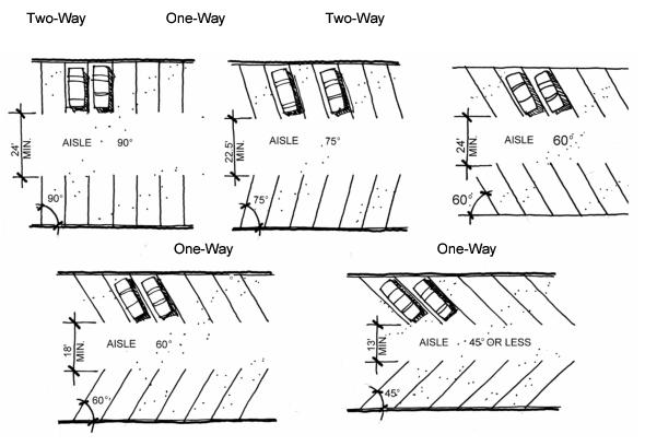
C. Compact Parking
Up to 15 percent of the total number of required parking spaces may be designated as compact spaces when clearly labeled.
D. Connectivity
Parking areas shall provide reasonable connectivity between adjacent parking areas on other sites without encouraging through traffic. Traffic calming devices may be required as necessary and shall be subject to the approval of the Public Works Director.
E. Parking
Each single-family dwelling shall have a minimum of two (2) off-street, parking spaces per lot. Required parking shall be prohibited within the front setback.
F. Curb or Roll Stops
Landscaping shall be protected from cars by a 6-inch curb or roll stops, where rocks or walls are not in place.
G. Dimensions of Parking Spaces
Required off-street parking spaces shall comply with the following dimensional standards:
|
PARKING SPACE DIMENSIONS |
|
|---|---|
|
Type of Space |
Size of Space |
|
Angled |
9 ft by 19 ft |
|
Compact |
7.5 ft by 16 ft |
|
Parallel |
9 ft by 23 ft |
|
Perpendicular |
9 ft by 19 ft |
H. Driveways
1. Driveway access, spacing, number and location shall comply with the City of Prescott General Engineering Standards.
2. Widths
Driveways shall conform to the following minimum widths at the gutter line, plus a minimum of 1-foot additional clearance on each side of a vertical obstruction exceeding 0.5 foot in height:
|
DRIVEWAY WIDTHS |
||
|---|---|---|
|
Use Served |
Number of Spaces |
Minimum Width (feet) |
|
Residential |
6 or less |
12 |
|
7+ |
12 if 1-way, 20 if 2-way |
|
|
Nonresidential |
24 or less |
12 if 1-way, 20 if 2 way |
|
25+ |
15 if 1-way, 4 if 2-way |
|
3. Sidewalk Crossings
Flat sidewalk surfaces at least 5 feet in width shall be preserved across all commercial driveways and alleys. Residential shall be minimum of 4 feet.
I. Landscaping
Off-street parking areas shall be landscaped in accordance with the standards of Sec. 6.5.6, Parking Area Landscaping. Greater screening may be required adjacent to less restrictive zoning district in accordance with Sec. 6.13, Residential Protection Standards.
J. Location
Except as otherwise expressly provided in this article (Refer to Sec. 6.2.10C), required off-street parking spaces shall be located on the same lot as the principal use.
K. Parking Striping and Signing
1. Each required off-street parking space and off-street parking facility shall be identified by surface markings arranged to provide for orderly and safe loading, unloading, parking and storage of vehicles; pedestrian walkways shall be striped or otherwise designated as needed.
2. All markings including striping, directional arrows, lettering on signs, accessible space field color shall be properly maintained in a highly visible condition at all times.
3. One-way and 2-way accesses into required parking facilities shall be identified by directional arrows as necessary. Any 2-way access located at any angle other than 90 degrees to a street shall be marked with a traffic separation stripe the length of the access. This requirement does not apply to aisles.
4. All striping and signing shall comply with the City of Prescott General Engineering Standards.
L. Vertical Clearance
The minimum vertical clearance for off-street parking spaces shall be 7 feet.
6.2.6 / Handicapped Accessible Spaces
Except single-family, duplex, patio home and townhouse development, a portion of the total number of required off-street parking spaces in each off-street parking area shall be specifically designated, located and reserved for use by persons with physical disabilities. All handicapped accessible parking spaces shall be counted toward off-street parking requirements. Medical facilities, both outpatient and surgical, require additional handicapped spaces consistent with the requirements from the City’s Building Division.
|
HANDICAPPED ACCESSIBLE SPACES |
|
|---|---|
|
Total Spaces in Lot |
Required Minimum Number of Spaces* |
|
1 -25 |
1 |
|
26 - 50 |
2 |
|
51 - 75 |
3 |
|
76 - 100 |
4 |
|
101 - 150 |
5 |
|
151 - 200 |
6 |
|
201 - 300 |
7 |
|
301 - 400 |
8 |
|
401 - 500 |
9 |
|
501 - 1000 |
2% of total parking |
|
1001 and over |
20 plus one for each 100 over 1000 |
|
*A minimum of one of every 8 accessible spaces must be van accessible. |
|
A. Minimum Dimensions
Handicapped accessible parking spaces shall comply with the parking space dimension standards of this Section, as follows:
1. Car-Accessible Spaces
Car-accessible spaces shall have at least a 5-foot wide access aisle located abutting the designated parking space.
2. Van-Accessible Spaces
Van-accessible spaces shall have at least an 8-foot wide access aisle located abutting the designated parking space.
3. Common Access Aisle
Vans and cars may share a common access aisle, provided it meets minimum van-accessible aisle width requirements described in A.2 above.
B. Location of Spaces
1. Required handicapped accessible parking spaces shall be located in close proximity to building entrances and shall be designed to permit occupants of vehicles to reach the building entrance on an unobstructed path.
2. Accessible spaces shall be grouped in pairs where possible.
C. Signs and Marking
Required handicapped accessible parking spaces shall be identified with signs and pavement markings identifying them as reserved for persons with disabilities. Signs shall be posted directly in front of the parking space at a height of no less than 42 inches and no more than 72 inches above pavement level. Van spaces shall be specifically identified as such. Such signs and markings shall be properly maintained.
6.2.7 / Alternate Transportation - Bike Racks (Except Single-Family and Duplex Projects)
Bike racks shall be provided at the same rate as Handicapped Accessible Spaces in accordance with the requirements for Sec. 6.2.6, Handicapped Accessible Spaces, up to a maximum of 15 required bike racks. The location of required bike racks shall be determined based on consideration of the safety and convenience of users.
6.2.8 / Passenger Loading Zones (Except Single-Family and Duplex Projects)
For every 100 required parking spaces, one (1) Passenger Loading parking space shall be provided. Location, markings, signage, etc., of such spaces shall be provided in accordance with City Code 9-1-10. Other Restricted Parking Areas. At least one half ( ½) of such spaces shall be van accessible. A bus or van pull out area near the main entrance may be permitted in lieu of such loading zone requirements.
6.2.9 / Vehicle Stacking Areas (Except Single-Family and Duplex Projects)
The vehicle stacking standards of this subsection shall apply unless otherwise expressly waived by the Community Development Director.
A. Vehicle Stacking Requirements
Off-street stacking spaces shall be provided as follows:
|
VEHICLE STACKING REQUIREMENTS |
||
|---|---|---|
|
Activity Type |
Minimum Stacking Spaces |
Measured From |
|
Automated Teller Machine |
3 |
Teller |
|
Bank Teller Lane |
4 |
Teller or Window |
|
Car Wash Stall, Automatic |
6 |
Entrance |
|
Car Wash Stall, Self-Service |
3 |
Entrance |
|
Gasoline Pump Island |
2 |
Pump Island |
|
Restaurant Drive-Through |
4 |
Order Box |
|
Restaurant Drive-Through |
6 |
Order Box to Pick-Up Window |
|
Unlisted Uses (Sec. 6.2.11E) |
Off-Street Parking Study, Sec.6.2.11E. Sec. 6.2.11F |
|
B. Design and Layout
1. Size
Stacking spaces must be a minimum of 8 feet by 20 feet in size.
2. Location
Stacking spaces may not impede on- or off-site traffic movements or movements into or out of off-street parking spaces.
3. Design
For traffic movement and safety, stacking spaces must be separated from other internal driveways by raised medians if deemed necessary by the Community Development Director.
6.2.10 / Alternative Parking Plans
Prior to the issuance of building permits, the Community Development Director may approve alternatives to the number and location of off-street parking spaces required by Sec. 6.2.3, in accordance with the requirements of Sec. 9.16, Administrative Adjustments, and this section.
A. General
1. Procedure
An Alternative Parking Plan as described in the subsections, below, may be amended by following the same procedure required for the original approval.
2. Filing of Approved Plans
A notarized original of an approved Alternative Parking Plan shall be filed with the City of Prescott on forms made available in the Community Development Department. The applicant shall provide such Alternative Parking Plan proposal prior to the issuance of building permits.
3. Violations
Violations of an approved Alternative Parking Plan constitute a violation of this Code and will be subject to the enforcement and penalty provisions of the City Code.
B. Shared Parking
The Community Development Director may approve shared parking facilities for developments or uses with different operating hours or different peak business periods if the shared parking complies with all of following standards.
1. Location
Shared parking spaces must be located within 300 feet of the nearest part of uses served, unless remote shuttle parking bus service is provided.
2. Zoning Classification
Shared parking areas require a zoning classification that permits commercial (stand-alone) parking lots.
3. Shared Parking Study
Those wishing to use shared parking as a means of satisfying off-street parking requirements must submit a shared parking analysis to the Community Development Director that clearly demonstrates the feasibility of shared parking. The analysis must be provided in a form established by the Community Development Director and, on completion, be made available to property owners within 200 feet of the proposed shared parking. At a minimum, the study must address the size and type of the proposed development, the composition of tenants, the anticipated rate of parking turnover and the anticipated peak parking and traffic loads for all uses that will be sharing off-street parking spaces.
4. Agreement for Shared Parking
In the event that an off-street parking area is not under the same ownership as the principal use served, a written agreement between the record owners will be required. A notarized original of the agreement between the owners of record must be submitted to the Community Development Director for review / approval and recordation by the County Recorder in a form established by the City Attorney. Recordation of the agreement must take place before issuance of a Building Permit for any use to be served by the off-site parking area. The Community Development Director may grant permission to dissolve an off-site parking agreement only if all required off-street parking spaces will be provided, in accordance with Sec. 6.2.3.
C. Off-Site Parking
The Community Development Director may approve the location of required off-street parking spaces on a separate lot from the lot on which the principal use is located where the proposed off-site parking complies with all of the following standards.
1. Ineligible Activities
Unless otherwise expressly permitted, off-site parking may not be used to satisfy the off-street parking standards for residential uses (except for guest parking), restaurants, convenience stores or other convenience-oriented uses.
2. Location
No off-site parking space may be located more than 600 feet from the primary entrance of the use served (measured along the shortest legal pedestrian route) unless remote shuttle parking bus service is provided. Off-site parking spaces may not be separated from the use served by a street right-of-way with a width of more than 80 feet, unless a grade-separated pedestrian walkway is provided, or other traffic control or remote shuttle parking bus service is provided.
3. Zoning Classification
Off-site parking areas require zoning that permits stand-alone parking lots or garages Refer to Sec.2.3 Use Table “Parking Lots, Stand Alone”.
4. Agreement for Off-Site Parking
In the event that an off-site parking area is not under the same ownership as the principal use served, a written agreement between the record owners shall be required that will run with the land. A notarized original of the agreement between the owners of record must be submitted to the Community Development Director for review / approval and recordation by the County Recorder in form established by the City Attorney. Recordation of the agreement must take place before issuance of a Building Permit for any use to be served by the off-site parking area. The Community Development Director may grant permission to dissolve an off-site parking agreement only if all required off-street parking spaces will be provided, in accordance with Sec. 6.2.3.
D. Fees In-Lieu of Parking
Within parking districts as may be established by the City Council from time to time, off-street parking requirements may be satisfied by payment of an in-lieu parking fee established by the City Council. Such payment shall be made before issuance of a Building Permit or a Certificate of Occupancy for such use; fee revenue shall be used to provide public parking in the general vicinity of the use. In establishing parking districts, the City Council may set limitations on the number of spaces or the maximum percentage of parking spaces required for which an in-lieu fee may be tendered.
E. Other Parking Alternatives
The Community Development Director may approve other parking alternative(s) upon determination that such alternative(s) will provide comparable protection to that afforded by otherwise applicable off-street parking standards for surrounding neighborhoods, while maintaining traffic circulation patterns and promoting quality urban design.
6.2.11 / Computing Requirements
The following rules apply when computing off-street parking requirements.
A. Multiple Uses
Unless a Shared Parking Plan (Sec. 6.2.10B) is approved for the project, lots containing more than one use must provide parking and loading in an amount equal to the total of the requirements for all uses.
B. Fractions
When measurements of the number of required spaces result in a fractional number, the fraction shall be rounded to the nearest whole number (e.g., 0.5 and higher shall be rounded up to 1.0).
C. Area Measurements
Unless otherwise specifically noted, all square footage-based parking and loading standards must be computed based on gross floor area as defined in this Code.
D. Occupancy or Capacity Based Standards
For the purpose of computing parking requirements based on employees, students, residents or occupants, calculations shall be based on the largest number of persons working on any single shift, the maximum enrollment or the maximum fire-rated capacity for assembly areas, whichever is applicable.
E. Unlisted Uses
Upon receiving a development application for a use not specifically listed in the off-street parking schedule (Table 6.2.3), the Community Development Director shall apply the off-street parking standard specified for the listed use that is deemed most similar to the proposed use or establish minimum off-street parking requirements on the basis of an Off Street Parking Study as provided by Sec. 6.2.11F below.
F. Off-Street Parking Study
Some uses have widely varying parking and loading demand characteristics, making it impossible to specify a single off-street parking or loading standard. Upon receiving a development application for a use identified in Table 6.2.3, as requiring a parking study, the Community Development Director may choose to apply the off-street parking and loading standard specified for the listed use that is deemed most similar to the proposed use or establish minimum off-street parking requirements on the basis of a parking and loading study prepared and paid for by the applicant. The study must include estimates of parking demand based on recommendations of the Institute of Traffic Engineers (ITE), or other acceptable estimates as approved by the Community Development Director and should include other reliable data collected from uses or combinations of uses that are the same as or comparable with the proposed use. Comparability will be determined by density, scale, bulk, area, type of activity, and location. The study must document the source of data used to develop the recommendations.
6.2.12 / Off-Street Loading (Except Single-Family and Duplex Projects)
A. No Use of Public Right-of-Way
Goods may be loaded or unloaded from streets in the DTB district and from other local streets where it is done safely. Except for the DTB district, such loading or unloading shall not be permitted from collector or arterial streets. No part of any vehicle shall be allowed to extend into the right-of-way of a collector or arterial street while being loaded or unloaded.
B. Design Standards
1. Location, Off-street
a. Plans for location, design and layout of all loading spaces shall be indicated on required site plans.
b. Required off-street loading spaces shall be on the site of the use served or on an adjoining site subject to a reciprocal parking easement allowing for such access.
c. On a site adjoining an alley, a required loading space shall be accessible from the alley.
d. No loading space may intrude into any portion of a required aisle, parking space or access area.
e. Loading areas shall be screened from view off-site in accordance with the requirements of Sec. 6.5.8F G, Loading Area.
2. Space Size
Off-street loading spaces, excluding maneuvering areas, shall be at least 10 feet wide and 25 feet long unless off-street loading will involve the use of semi-tractor trailer combinations or other vehicles in excess of 25 feet in length, in which case the minimum size of a space shall be 12 feet by 65 feet.
C. Minimum Loading Space Requirements
Off-street loading spaces shall be provided for all proposed structures containing commercial, business, industrial, manufacturing, storage, warehousing, processing, offices, hotels, hospitals, airports, railroad terminals, and other uses as may be required by the Community Development Director in accordance with the minimum requirements listed in Table 6.2.12.
|
MINIMUM LOADING SPACE REQUIREMENTS |
||
|---|---|---|
|
Facility Size (Gross Square Feet) |
Minimum Number of Spaces |
|
|
Office Uses |
Other Nonresidential, Commercial and Industrial Uses |
|
|
0 to 10,000 |
1 |
1 |
|
10,001 to 50,000 |
1 |
2 |
|
50,001 to 100,000 |
2 |
3 |
|
Each additional 100,000 |
0.5 |
1 |
|
Structures less than 10,000 square feet may provide a loading space of a size and at such location as is consistent with the use of the structure. |
||
D. Surfacing and Maintenance
Off-street loading areas shall be kept in a dust-free and mud-free condition at all times. Loading areas located between a public street or alley and the principal building on the parcel shall be paved.
Sec. 6.3 / Access Management
Access to Collectors, Arterials and State Highways shall be based on the City of Prescott General Engineering Standards.
A. Entrances and exits shall be located so as to maximize separation from intersections.
B. Entrance widths for commercial uses shall not exceed 40 feet.
6.3.3 / Shared Access and Connectivity
Shared access and internal connectivity between adjacent properties and parking lots shall be required as necessary to promote safe ingress and egress from fronting streets.
6.3.4 / Street Intersections and Curb Cut Separations
A. Street Intersection and Curb Cut Separation for all street classifications shall be in accordance with the General Engineering Standards, Table 6-9.
B. Curb Cut Separation on State Highways and Major Arterials
Recorded easements for shared access, provision of acceleration/deceleration lanes, traffic signals and other right-of-way improvements, for these cuts may be required prior to approval of rezoning or development approval.
C. Curb Cut Separation on Minor Arterials and Commercial/Industrial Collectors
Recorded easements for shared access may be required prior to approval of rezoning or development approval. Adjoining parcels under common ownership may be required to share a curb cut.
D. Limited Access
Corner parcels may be required to have all access from a side street as determined by the Public Works Director. A non-vehicular easement may be required to restrict curb cuts to approved locations.
Intersections shall be constructed in accordance with the City of Prescott General Engineering Standards.
Curb cut locations shall provide adequate stacking distance along streets intersecting highways and arterials as determined by the General Engineering Standards.
6.3.7 / Signalized Intersections
Major employment sites and retail centers shall have access to a signalized intersection, unless waived by the Public Works Director.
Deceleration lanes may be required as noted in the General Engineering Standards.
Off-site improvements may be required in accordance with the requirements of the Prescott City Code, XIV, Chapter 1 (Attached as Appendix F).
6.3.10 / Corner Setbacks and Intersection Visibility
The following standards shall apply at the corner of intersecting streets, alleys and driveways, except in the DTB District.
A. No structure or planting (at mature growth) that exceeds 3 feet in height shall be permitted within a corner setback. Exceptions are permitted for utility poles, lighting standards, mail boxes, City or state traffic signs, and existing trees if the lower canopy of the trees allow a clear line of sight between 3 feet and 7 feet above the street grade. A sign permitted by Sec. 6.11 may be located within the intersection visibility area, provided, that visual clearance exists between 3 feet and 7 feet above the ground.
B. Corner setbacks for sight distance extend within the area formed by the legs of a triangle whose apex is the point of intersection of the curbs of the adjacent streets. Where no curbs exist, such setbacks shall be extended from the point of intersection of the rights-of-way lines on the adjacent streets, instead of from the curb.
C. Minimum corner setbacks, as measured from the curbline, shall be provided consistent with the requirements of Sec. 6.3.10B. and Table 6.3.9.
D. Intersection sight visibility triangle easements shall be required to limit the height of obstructions in accordance with the City of Prescott General Engineering Standards.
|
MINIMUM CORNER SETBACKS |
||
|---|---|---|
|
Intersection Type |
X |
Y |
|
Street-to-Street |
40 feet |
40 feet |
|
Street-to-Driveway |
40 feet |
20 feet |
|
Driveway-to-Driveway (on-site) |
20 feet |
20 feet |

Minor modifications to the above standards may be considered on their merits by the Public Works Director where the intent for the majority of the standards is satisfied and the public health, welfare and safety is protected.
Sec. 6.4 / Fences and Walls
The purpose for this section is to provide for adequate privacy and security without impeding or obstructing vision at intersections.
No fence or wall may be erected or maintained in any zone in violation of the standards of this section.
It shall be unlawful to install or construct or cause to be installed or constructed any fence or wall more than 4 feet in height, or any retaining wall within the height limits outlined in the General Engineering Standards, Table 2-2, without obtaining a permit. All applications for fence or wall permits shall be submitted to the Building Official and shall be accompanied by a sketch or design of the proposed fence or wall and a site plan showing the location of the proposed fence or wall. All retaining walls shall be designed by a professional registrant and built in conformance with the City of Prescott General Engineering Standards.
6.4.4 / Fence and Wall Location and Height
A. In all zoning districts, fences and walls located in a required front yard shall not exceed 4 feet in height except for qualifying flag lots, fences and walls 6 feet in height are allowed in a required front yard in instances where the front property line of a flag lot adjoins a rear lot line of an adjoining lot / parcel.
B. In all zoning districts, fences and walls located within required side or rear yards shall not exceed 6 feet in height; except in the IL district and IG district, such fences may be 8 feet in height when used for nonresidential purposes.
C. Fence height shall be measured in accordance with the requirements of Sec. 2.7.3E.1.c.
D. All fences, walls and hedges shall be subject to the provisions contained in Sec. 6.3.10. Corner Setback and Intersection Visibility.
E. Fences and walls shall be erected with the finished side presented to the exterior of the property being fenced.
6.4.5 / Barbed- or Razor-Wire and Electric Fences
Barbed-wire or razor-wire and electric fences shall be subject to the following requirements:
A. In all residential zoning districts, the use of electrified or barbed wire is prohibited within 10 feet of a City street.
B. The use of razor wire is prohibited in all districts, except in the IL district and IG district.
C. Notwithstanding other provisions to the contrary, where razor wire is allowed, it shall be placed not less than 6 feet from the ground at the fence line and shall not exceed 10 feet in height.
D. In no case shall barbed-wire or razor-wire project into a City right-of-way.
E. Where the use of barbed-wire or razor-wire, or electrified fence is a threat to public safety, removal in part or whole shall be required upon notification to the property owner.
F. Game-friendly fencing may be required for new and replacement wire fencing in agricultural/ ranching areas.
6.4.6 / Fences or Walls Required for Swimming Pools & Contained Water Bodies
A. Fenced or walled enclosures shall be provided for all swimming pools or other contained bodies of water intended for swimming that contains water 18 inches or more in depth at any point and that is wider than 8 feet at any point in accordance whether below-ground or above-ground, unless fully enclosed in a building, as follows:
1. Be entirely enclosed by at least a 5 foot wall, fence or other barrier as measured on the exterior side of the wall, fence or barrier; and
2. Have no openings in the wall, fence or barrier through which a spherical object 4 inches in diameter can pass; and
3. The horizontal components of any wall, fence or barrier shall be spaced not less than 45 inches apart measured vertically or shall be placed on the poolside of a wall, fence or barrier, which shall not have any opening greater than 1¾ inches measured horizontally; Wire mesh or chain link fences shall have a maximum mesh size of 1¾ inches measured horizontally; and
4. The wall, fence or barrier shall not contain openings, handholds or footholds accessible from the exterior side of the enclosure that can be used to climb the wall, fence or barrier; and
5. The wall, fence or barrier shall be at least 20 inches from the water’s edge; and
6. If a residence or living area constitutes part of the required enclosure for a swimming pool or other contained body of water, in lieu of the above requirements there shall be one of the following:
a. Between the swimming pool or other contained body of water and the residence or living area, a minimum 5 foot wall, fence or barrier to the pool area which meets all of the requirements of Sec. 6.4.6A.2 through Sec. 6.4.6A.5; or
b. The pool shall be protected by a motorized safety pool cover which requires the operation of a key switch, which meets the American Society of Testing and Materials Emergency Standards §13-89 and which does not require manual operation other than the use of the key switch.
B. Gates for the enclosure shall:
1. Be self-closing and self-latching with the latch located at least 54 inches above the underlying ground or on the pool side of the gate with a release mechanism at least 5 inches below the top of the gate and no opening greater than ½ inch within 24 inches of the release mechanism or be secured by a padlock or similar device which requires a key, electric opener or integral combination, which can have the latch at any height; or
2. Open outward from the pool.
C. All ground level doors or other doors with direct access to the swimming pool or other contained body of water not otherwise excepted below shall be equipped with a self-latching device, which meets the requirements of Sec. 6.4.6B.1. Emergency escape or rescue windows from sleeping rooms with access to the swimming pool or other contained body of water shall be equipped with a latching device not less than 54 inches above the floor. All other operable dwelling unit or guest room windows with similar access shall be equipped with a screwed-in-place wire mesh screen, or a keyed lock that prevents opening the window more than 4 inches, or a latching device located not less than 54 inches above the floor.
D. Where a swimming pool or hot tub is aboveground, it shall have non-climbable exterior sides, which are a minimum height of 5 feet. Any access ladder or steps shall be removable without tools and secured in an inaccessible position with a latching device not less than 54 inches above the ground when the pool is not in use.
E. This Section shall not apply to:
1. A system of sumps, irrigation canals, irrigation, flood control or drainage works constructed or operated for the purpose of storing, delivering, distributing or conveying water;
2. Stock ponds, storage tanks, livestock operations, livestock watering troughs or other structures used in normal agricultural practices; and
3. A swimming pool or contained body of water or barrier constructed prior to the effective date of this amendment if such bodies of water or barriers were in compliance of all applicable codes and regulations at the time of construction.
Sec. 6.5 / Landscaping and Screening
 This Article provides standards for the installation and maintenance of landscaping, walls and screening devices in order to preserve and enhance the natural environment and beauty of the City, to minimize the adverse effects of development, and to promote the general welfare of the citizens of Prescott. Landscaping materials, including ground cover, shrubs, and trees facilitate the control of erosion and the reduction of glare and dust, and soften the visual impact of building masses. Walls and screening devices allow the separation of potentially incompatible uses and the buffering of road noise and intensive activities. Landscaping, walls and screening devices together help to effectuate privacy, logical development, and enhancement of property values. In order to preserve the unique natural character of the City, these standards emphasize the retention of native trees, shrubs, rock formations, and other natural site features. To conserve water resources, use of drought tolerant plant materials and efficient irrigation systems is required. See Section 6.5.5.C.
This Section shall apply to:
A. All new multi-family and nonresidential development;
B. Change of use from residential to nonresidential where City approvals are required;
C. Change of use from single-family to multi-family residential where City approvals are required; and
D. Expansion, remodeling, and renovation of existing buildings on a lot or building tract, or a related or standalone parking lot shall provide an amount of landscaping and screening commensurate with the level or scale of the improvements.
A. Landscape and Site Plan
All proposed buildings and uses shall be shown on a landscape and site plan prepared by an individual or firm registered with the Arizona Board of Technical Registration, unless waived by the Community Development Director. Landscaping shall be installed per approved plan unless otherwise modified by the Community Development Director. All landscape and site plans shall indicate:
1. Location of existing and proposed buildings, parking areas, drainage and street improvements;
2. Location of existing trees outside of building footprints;
3. Locations and general types of landscaped treatment areas – i.e., lawn areas, low-water use areas, and inorganic areas;
4. Proposed plant or inorganic materials to be used in each treatment area;
5. Underground irrigation systems to be used in each planted area;
6. Curbs, walls and screening devices;
7. Permanent slope stabilization requirements; and
8. Plant palette reflecting low-water use plants from the ADWR Prescott Active Management Area. Plant List: https://www.azwater.gov/sites/default/files/2024-11/2024_PRAMA5MPLWUPL_Final.pdf
B. Location of Utilities and Drainage Facilities
1. Existing and proposed utilities shall be located, when possible, so that their installation will not adversely affect vegetation to be retained on a site.
2. Drainageways and detention basins may be located within landscaped areas when designed compatible with the planted area and plant species, in accordance with the City of Prescott General Engineering Standards.
C. Installation
Landscaping, underground irrigation systems, walls and screening structures shall be installed in accordance with the approved landscape or screening plan prior to issuance of a final Certificate of Occupancy for the building or use. The Building Official may grant a temporary Certificate of Occupancy for up to 6 months when a performance bond is provided by the applicant to guarantee the completion of any incomplete landscape or screening improvements.
D. Maintenance Requirements
1. Unless otherwise specified, the maintenance of landscaping in the public right-of-way is the responsibility of the adjacent property owner, whether an individual, corporation, or homeowner’s association.
2. Landscaped areas shall be reasonably maintained by the owner or the lessee of the property, including pruning, trimming, weeding, and other requirements necessary to create an attractive appearance for the development. Lack of maintenance of required landscaping material shall constitute a violation of this Code.
3. Plant materials not surviving shall be replaced within 90 days of its demise.
E. Landscaping in Rights-of-Way
Approval of the Public Works Director is required prior to placing landscaping and other improvements in rights-of-way.
F. Irrigation
State List of Drought Tolerant Plants (PDF)
All required landscaped areas shall include a permanent, underground water irrigation system including an EPA WaterSense approved programmable timer to ensure the long-term health and growth of the landscape. Irrigation system design shall take into consideration the water-demand characteristics of plant or landscape materials used. Alternative irrigation systems may be approved by the Community Development Director subject to proven effectiveness.
G. Site Disturbance
Any portion of a site disturbed by site preparation and/or construction, especially cut or fill slopes, shall be adequately revegetated and stabilized, prior to issuance of a Certificate of Occupancy in accordance with the City of Prescott General Engineering Standards.
6.5.4 / Existing Vegetation - Replacement and Credits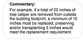
A. To the extent practical, existing significant landscape features shall be preserved and incorporated into the final landscape and site plans. Existing landscaping may be used to meet the requirements of this Code if it meets the purpose and intent of this Article and is included on the approved landscape plan. Such vegetation shall be protected during all phases of site development and given sufficient area and means for growth and water absorption. A credit of up to 200 percent may be allowed toward shrubs otherwise required pursuant to Sections 6.5.5, Minimum Landscaping Standards; 6.5.8, Screening Standards; and 6.5.6, Parking Area Landscaping, for every shrub greater than 2 square feet that is preserved or transplanted.
B. The tree replacement requirement shall be 50 percent of the total caliper of trees removed from outside of the building envelope. A 200 percent credit toward the tree replacement requirement shall be granted for retaining and preserving healthy trees 4 inches or greater in caliper size, excluding invasive species as defined by the City. This tree credit shall also count toward required landscaping in Sections 6.5.5, Minimum Landscaping Standards; 6.5.8, Screening Standards; and 6.5.6, Parking Area Landscaping. Trees to be preserved shall be adequately protected from vehicles, undermining or collapse.
6.5.5 / Minimum Landscaping Standards
All undeveloped areas of each lot or tract and the adjacent right-of-way or parkway shall be landscaped with trees, shrubs, grasses, ground cover and other organic and assorted inorganic materials that create an attractive appearance in accordance with the requirements of this Section; provided, however, smooth concrete or asphalt surfaces are not landscaping. Clustering of trees and shrubs is encouraged. In addition to the applicability listed in Section 6.5.2, this Section also applies to subdivisions as defined by Section 11.2.5.
A. Trees, Shrubs, and Grasses
Recommended plant materials for on-site landscaping are listed in the Arizona Department of Water Resources Low Water Use/Drought Tolerant Plant List – https://www.azwater.gov/sites/default/files/2024-11/2024_PRAMA5MPLWUPL_Final.pdf. Minimum landscaping shall include the following frequency and size of plantings:
1. Trees
One tree shall be utilized per 25 linear feet (in no case closer than 25 feet apart) of required landscaped area.
2. Shrubs
Four shrubs per 250 square feet (or fraction thereof) of required landscaped area shall be provided.
3. Grasses, ground covers, and inorganic materials
Any combination of grasses, ground covers, and inorganic materials may be used for the balance of the required landscaping at the developer’s discretion; however, a dressing of gravel, decomposed granite or mulch shall be required to hold moisture, slow runoff, and restrain weed growth. Such dressing material shall be selected and sized to withstand potential removal by wind and stormwater flows.
B. Plant Types/Minimum Plant Sizes
The following minimum plant size requirements shall apply in all cases:
|
PLANT TYPE/ MINIMUM PLANT SIZES |
|
|---|---|
|
Deciduous Trees |
1 to 1.5 inch caliper (measured 1 foot above ground) |
|
Evergreen Trees |
5 feet tall |
|
Shrubs |
5-gallon container size + 18 inches tall |
|
Woody Ground Cover |
1-gallon container with 12-inch spread |
C. Landscape Plant List
1. All Applicable Properties and Public Rights-of-Way
Plants used to satisfy landscape requirements shall be limited to those listed in the current Arizona Department of Water Resources Low Water Use/Drought Tolerant Plant List.
6.5.6 / Parking Area Landscaping
Parking lot landscaping shall be subject to the following minimum standards:
A. Parking Lot Perimeters
1. Street Frontages
a. All parking lots adjacent to a street shall be landscaped with a minimum width of 10 feet on site (measured from the right-of-way edge), with plantings as specified in Section 6.5.5, Minimum Landscaping Standards. Right-of-way edges shall be cleaned up and integrated with the street frontage landscaping. The minimum landscape strip may be reduced along part of the frontage provided an average landscaped width of 10 feet is maintained along the overall frontage.
b. In addition, parking areas with street frontages longer than 200 feet shall be screened from street view to a height of 3 feet with a masonry wall, berm or dense landscaping, or a combination of 2 or more of these elements. Such walls shall utilize materials and otherwise be designed to be compatible with the architecture of the principal structure on the site. Landscaping shall be provided adjacent to the outside of such walls with plantings as specified in Section 6.5.5, Minimum Landscaping Standards.
2. Other Parking Perimeters
Nonfrontage perimeters of a parking lot shall be landscaped with a 5-foot-wide landscape strip with plantings as specified in Section 6.5.5, Minimum Landscaping Standards. This minimum landscape strip may be reduced to 3 feet when a minimum 3-foot-high wall is provided in accordance with subsection A.1.b of this section.
3. Transfer of Required Landscaping
The Community Development Director may approve the transfer of required parking area landscaping from required locations to other locations on the site, provided the purpose for this Section is achieved.
4. Landscape Protection
All landscaped areas adjacent to vehicular parking and access areas shall be protected by 6-inch vertical concrete curbing, 6-inch precast bumpers, or similar materials in order to control stormwater flows and minimize damage by vehicular traffic. Curb cuts and curb borings should be utilized to direct stormwater to the planting areas. Vehicles may overhang landscaped areas up to 2 feet into landscaped areas that are at least 5 feet wide, but may not overhang sidewalks and other pedestrian walkways. This provision applies equally to vehicle display areas.
B. Landscaped Islands
Parking lots with more than 50 spaces shall provide landscaped parking islands according to the following standards:
1. All landscaping parking islands shall be a minimum of 4 feet wide and contain a minimum of 40 square feet in area; provided, however, landscape islands may be aggregated into fewer and larger islands that meet overall planting and area standards.
2. A minimum of 1 tree and 2 shrubs for every 10 parking spaces shall be preserved or planted within the parking lot.
3. No parking space is farther than 100 feet from a landscaped area.
4. These requirements may be modified upon approval of the Community Development Director where exceptional design of the parking lot merits such modification and where the intent of the standard is met through alternate design schemes.
One small (under-story) tree and 4 shrubs per 50 linear feet of building wall shall be required within 4-foot minimum width planters along all building walls that are 50 feet or longer; provided, however, that this requirement shall not apply where other required landscaping adjoins the building or where such walls are not visible from surrounding streets.
Where screening is required by this Code, minimum screening in accordance with the following standards shall apply in addition to other applicable requirements. Existing vegetation or natural conditions may be used to satisfy these requirements (See Section 6.5.2, Applicability).
A. Screening Materials
Screening may be accomplished by the use of plants, earth berms, solid walls, or trees and shrubs in combination as necessary to produce an effective screening from view off site of the use or facility requiring screening within a reasonable time.
B. Screening Plant List
Plants used to satisfy any required screening standards shall be limited to plants with a mature height of between 6 and 15 feet and foliage characteristics similar to those of the recommended plants for this purpose (see “Commentary” below).
C. Height of Screening Devices
The height of screening devices shall be measured from the highest finished grade adjacent to the screening device to maximize effectiveness in accordance with the maximum fence height requirements of Section 2.7.3.E.1.c.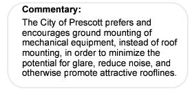
D. Outdoor Storage Areas
All outdoor storage areas for materials, heavy equipment, or other similar items shall be screened from street view by a minimum 6-foot-high screening device. Such screening device shall consist of plant material and/or a wall constructed of or finished with materials compatible with the principal structure on the site.
E. Mechanical Equipment
1. Roof-mounted equipment shall be screened from view from the adjoining street(s) or alley(s) in a manner integrated with the roof structure and color.
2. Ground-mounted mechanical equipment shall be screened from off-site view by a screening device consisting of either plant material, a wall constructed of or finished with materials to match the principal structure on the site, a lattice, or other similar containment.
F. Dumpsters and Solid Waste Receptacles
Dumpsters and receptacles shall be built in accordance with City of Prescott Standard Detail 144P, Sanitation Dumpster, and completely screened from view of adjacent property in a more restrictive zoning district by a minimum 6-foot-high screening wall that is at least 1 foot taller than the dumpster or solid waste receptacle.
G. Loading Area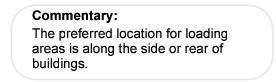
Loading areas shall be screened from view off site on 3 sides by a solid fence, finished wall, or hedge at least 6 feet in height.
Sec. 6.6 / Drainage, Floodplains and Drainageways
This Section is intended to protect drainageways from alteration in order to uphold their primary function as stormwater facilities. Developments within FEMA-delineated floodplain boundaries shall adhere to the Floodplain Regulations of the Prescott City Code, Title XIII. All drainage shall be designed by an Arizona licensed Professional Engineer following the City of Prescott General Engineering Standards.
All development, including fences and walls, proposed in drainageways or floodplains shall be subject to the following requirements:
A. Minimize or Prohibit Development in Drainageways
In instances where a drainageway exists but there is insufficient area on the site to allow residential use, development shall be minimized or prohibited where one of the following exists:
1. Site planning and engineering techniques cannot reasonably mitigate potential hazards to public health, safety and welfare; or
2. Alteration will limit or reduce the primary function as storm water facilities; or
3. Development subjects persons or the City to dangers or expenses required to mitigate hazardous conditions, respond to emergencies created by such conditions or rehabilitate improvements and lands.
A. Drainage improvements shall be designed and constructed in accordance with the City of Prescott General Engineering Standards and shall meet the following requirements:
1. Drainage detention basins and large drainage structures shall be designed and constructed within a common area/open space and dedicated on the final plat to be owned and maintained by the HOA/POA in perpetuity.
2. An Arizona-registered engineer shall design and certify drainage improvements.
3. Adequate provision for short- and long-term ownership, maintenance and operation of the storm water management system shall be required.
4. Water supply systems and sanitary sewage systems shall be designed to minimize or eliminate infiltration of floodwaters.
5. Individual lot owners shall be responsible for the maintenance of driveway culverts and smaller cross lot drainage within, through and over their property, which shall be within dedicated drainage easements shown on the final plat.
Sec. 6.7 / Site Disturbance, Grading, and Restoration Standards
This Section is intended to limit site disturbance and to promote restoration of developed sites to a more stable, natural and attractive appearance.
This section shall apply to all development that involves either:
A. Disturbance, grading or placement of more than 50 cubic yards of material; or
B. Grubbing of more than 10,000 square feet; or
C. As may otherwise be required in accordance with the City of Prescott General Engineering Standards, provisions of Table 6.7.7, ADEQ Stormwater Pollution Prevention Plan (SWPPP) requirements or City Code, Title 16.
This section shall not apply to the following development activities:
A. Selective thinning of vegetation for fire control as approved by the Fire Chief; or
B. Individual single-family home construction may be excepted where slopes are less than 20% or where the site will not be subject to mass grading.
A. Site disturbance shall only occur pursuant to an approved construction plan, associated with a grading or building permit, having temporary erosion controls and/or a SWPPP and permanent slope stabilization. Such site disturbance proposals shall be reviewed and approved by the Public Works Department in consultation with the Community Development Department to ensure compliance with applicable conditions of approval and bank stabilization landscape requirements.
B. A site disturbance and grading permit shall not be issued for any parcel without a preliminary plat or a preliminary site development plan that is approved by the Community Development Director.
C. Financial Assurance shall be posted for all site disturbance and grading in accordance with the General Engineering Standards, Section 1.4, Financial Assurances, prior to permitting.
D. All site disturbance, grading and restoration (bank stabilization) plans shall be prepared by an Arizona-registered civil engineer.
6.7.5 / Single Site (Commercial or Multi-Family Residential) Development Bonding and Certification
A. Financial assurances shall be posted in accordance with the General Engineering Standards, Section 1.4, to ensure compliance with the requirements of this Code.
B. The Design Engineer shall make sufficient inspections to certify that site grading, drainage and restoration are completed per approved plans. The financial assurance shall be released following such certification by the design engineer and verification by the City Engineer.
C. Single commercial or multi-family sites disturbed prior to a building permit being issued shall complete bank stabilization within three (3) months of completion of site disturbance or within one (1) year of commencing site disturbance, whichever occurs first. Extensions may be approved by the City Council. In cases where bank stabilization/scarring mitigation is achieved through screening by a building, issuance of a building permit is required prior to site disturbance.
D. For the exception of single-family home sites that are not a part of a larger plan of development, prior to any ground disturbance, all projects shall post a financial assurance in accordance with the General Engineering Standards, Section 1.4 for bank stabilization. Prior to final subdivision release or certificate of occupancy, certification shall be provided by the project engineer or landscape architect documenting that the bank stabilization was completed according to plan.
Site grading plans shall be in accordance with the following minimum standards:
A. Portions of the site or lot to be disturbed shall be clearly identified on the grading plan as the “disturbed area(s)” or “disturbed area envelope”. Grubbing, grading, and clearing may occur only within the disturbed area(s) identified on the approved grading plan.
B. Portions of the site or lot not identified in the grading plan as a disturbed area(s) shall not be used for stockpiling of materials or excess fill.
C. To direct drainage away from building foundations, a minimum slope shall be maintained as follows:
1. A minimum 5% (1 to 20) fall within 10 feet of all structures.
D. All residential development shall comply with the following requirements:
1. The maximum height of an exposed vertical cut or fill shall not exceed 35 feet.
2. The maximum length of an exposed vertical cut or fill shall not exceed 150 feet.
E. Backfilled areas shall be compacted per the approved Site Disturbance and Grading Plan and revegetated or otherwise stabilized in accordance with the requirements of this Sec. 6.7, and certified by an Arizona registered Geo Technical Engineer.
F. Edges of cuts and fills shall be reshaped to conform to the natural topography of the land.
G. Commercial development shall not be restricted in terms of height of cut or fill, subject to certification of soil stability and scarring mitigation.
H. Cuts and fills on slopes that encroach into a local drainage tributary (i.e., non F.E.M.A. stream) shall be identified and armored to protect against a 100-year storm event.
I. Excess material shall be placed per the approved site disturbance and grading plan, and drainage plan, or removed to an approved off-site disposal area. The approved disposal site, if within City limits, shall be subject to provisions of the Land Development Code and City Code, Title 16.
J. All site re-vegetation shall be completed within 90-days of completion of grading work, or prior to release of subdivision guarantee or issuance of certificate of occupancy, whichever occurs first.
K. Where natural areas or preserved vegetation is designated on a site or lot, temporary fencing shall be installed where they abut construction areas in order to prevent site disturbance in said natural areas.
L. Exposed cut and fill slopes shall be re-vegetated, stabilized and finished in accordance with the requirements Sec. 6.7.7, Cuts and Fills.
M. A slope stability analysis shall be required by an Arizona registered Geo Technical Engineer prior to disturbing slopes exceeding 2:1, horizontal to vertical.
N. The top of cutbanks shall be located a minimum of 5 feet inside the subject property boundary.
O. The toe of fill slopes shall be set back inside the subject property boundary a minimum of 2 feet or ½ the fill height, whichever is greater.
A. Bank Stabilization Plans
For all projects, stabilization is required for cut and fill slopes 2 feet or higher. The intent is to permanently stabilize and visually screen or enhance cut and fill banks using one of the treatments in Table 6.7.7, Cuts and Fills.
1. A bank stabilization plan shall be subject to the approval by the Public Works Department (in consultation with the Community Development Director). Modification of such approved bank stabilization plans may be approved if necessary due to soil conditions and pursuant to the provisions of Table 6.7.7.
2. Subdivision development shall include bank stabilization and/or landscape plans for all areas disturbed during subdivision construction.
3. Prior to obtaining a building permit, single commercial or multi-family sites proposed for stockpiling, grading and/or grubbing shall submit a Bank Stabilization Plan along with grading, drainage, and temporary erosion control plans, and a site plan consistent with the requirements of this Code.
4. Single commercial or multi-family sites disturbed prior to a building permit being issued shall complete bank stabilization within 3 months of completion of site disturbance or within 1 year of commencing site disturbance, whichever occurs first. Extensions may be approved by the City Council. In cases where bank stabilization/scarring mitigation is achieved through screening by a building, issuance of a building permit is required prior to site disturbance.
5. For the exception of single-family home sites that are not a part of a larger plan of development, prior to any ground disturbance, all projects shall be subject to the posting of financial assurances in accordance with the General Engineering Standards, Section 1.4 for the total cost of bank, stabilization. Prior to final subdivision release or certificate of occupancy, certification shall be provided by the project engineer or landscape architect documenting that the bank stabilization was completed according to plan.
a. If due to climactic conditions, the permanent slope stabilization is not completed or established at time of release, an additional 10% of the total financial assurance or the actual cost of slope stabilization, whichever is less, shall be withheld pending the completion of slope stabilization, per approved plans, the General Engineering Standards, and LDC requirements.
|
BANK STABILIZATION REQUIREMENTS AND OPTIONS |
||
|---|---|---|
|
Development Type |
Standards |
Bank Stabilization Options |
|
Single-Family Subdivisions, and Single-Family Development on Individual Lots |
A bank stabilization plan, for cut & fill banks >2 ft. high, within and outside of ROW, shall be included w/ project permit applications (e.g., Building Permit, Site Disturbance and Grading Permit, Paving Permit) A Landscape Architect or Licensed Landscaper shall prepare stabilization plans for banks >8’ visible from streets and shall submit such plans for City approval. Where structural designs are submitted, a registrant shall design and so certify. |
Revegetated banks are required where practical and may include combination of reseeding/seed mats, trees, shrubs, groundcover, rock, & riprap. Plant type, size, and coverage shall be sufficient to stabilize and begin restoring w/in 3 yrs. Temporary automatic irrigation is required to establish plants; permanent drip may be required for highly visible planted banks. Planted surfaces shall be amended with topsoil a min. 3-6 in. deep, and shall be sufficiently laid back to support plantings: 2:1 north facing, 2.5:1 east facing, 3:1 south and west facing. This is intended to permit terracing with steeper faces between planted platforms. Manufactured banks >8 ft. high, visible from nearby streets or neighborhoods, shall be formed to create a more natural appearance (a combination of rough cut, undulating, and/or rounded toe and top of slope), and terraced where possible to improve plant establishment. Retaining walls, where visible from streets or nearby neighborhoods, shall be terraced or treated to blend into the natural landscape (e.g., tinted concrete, rock facing, slump block, RR ties, and/or plantings). Unfinished poured concrete and unfinished concrete block walls are not permitted where visible from streets and nearby neighborhoods. Non-planted banks are permitted for exposed bedrock cuts, or where the building will effectively screen the cut and/or fill bank in a timely manner. Where bedrock cuts higher than 8’ are visible from streets or neighborhoods, they shall be formed to create a more natural appearance (a combination of rough cut, undulating, and/or rounded toe and top of slope). Additional treatment of cut faces may be required to stabilize soil and reduce scaring effects, based on proven effective technologies and products. |
|
Commercial Site Developments, Subdivisions, Subdivision Exemptions, and Single Commercial Sites Disturbed Prior to Building Permit. |
Same as above |
|
|
Public And Private Rights-Of-Way |
Same as Above |
|
This section is intended to provide for adequate temporary and permanent erosion and drainage control practices that help protect against property damage, flooding, sedimentation, and costly and repeated maintenance. Any permit which involves site disturbance, shall comply with the City of Prescott General Engineering Standards, this section, Sec. 6.7.6, Grading Standards, and Sec. 6.7.7, Cuts and Fills.
A. Temporary erosion control plans, their implementation and maintenance during construction shall be required of all subdivisions, subdivision exemptions, street construction, and individual developments including all commercial and all single-family home sites.
B. Erosion control plans shall be submitted along with building, subdivision, and street construction plans, and approved prior to site disturbance. The same shall be required of commercial sites proposed for disturbance prior to a building permit.
C. Suitable erosion control methods may include, but are not limited to, silt fences, hay bales, diversion channels, sediment basins, and graveled roadbeds.
D. In the event of the failure to control erosion and sedimentation adequately, the property owner and/or developer and/or contractor shall be responsible for any and all costs or damages resulting there from.
E. Temporary erosion controls shall be removed once permanent improvements, such as bank stabilization, and landscaping are in place and established. When permanent improvements such as landscaping are not yet established, post construction Best Management Practices (BMPs) may be required, as approved by the City.
F. A stormwater pollution prevention plan (SWPPP) and report in binder form with an approved ADEQ NOI shall accompany plan submittals, if applicable.
|
EROSION CONTROL REQUIREMENTS |
||
|---|---|---|
|
Development Type |
Standards |
Additional Allowances and Requirements |
|
Single-Family Residential Lot Development (i.e., development of single family homes on individual home sites) |
All SFR site plans shall include a temporary erosion control plan, and the size and location of driveway culvert. Temporary driveway entrances require a ROW encroachment permit per City Code Sec. 8-2-2, the application for which shall include effective erosion controls. |
SFR homes on slopes greater than 20% are limited to disturbable area envelopes as specified in Sec. 6.8.3, Residential Density Allocation and Maximum Site Disturbance. SFR homes on slopes up to 20% are limited to lot coverage per underlying zone unless developed as a PAD. |
|
Residential Subdivision Development |
For all subdivisions regardless of slope, a stormwater protection plan (such as for N.P.D.E.S. including temporary erosion controls, drainage, and grading) shall be submitted and approved prior to site disturbance. |
Residential subdivision density on slopes greater than 20% is limited pursuant to the requirements of Table 6.8.3; otherwise, densities are permitted per underlying zone. Bank stabilization is required of all subdivisions. |
|
Commercial Site Development, Subdivisions, Subdivision Exemptions, and Commercial Sites Disturbed Prior to Building Permit |
For all commercial projects regardless of slope, a stormwater protection plan is required as above. Disturbed building pads not completed within 18 months may be required to be reseeded to stabilize soil permanently, as needed. |
Extent of site disturbance shall not be limited based on slope steepness or height of manufactured bank, however mitigation of cut and fill scarring through bank stabilization is required (see Table 6.7.7 for options). |
|
Public And Private Rights-Of-Way Development |
A stormwater protection plan is required of all street projects, as above |
Same as above |
Sec. 6.8 / Hillside Development Standards
Prescott is surrounded by rolling hills and mesas. These hilly areas exhibit steep slopes, which may contain unstable rock. Development on potentially unstable rock can be hazardous to life and property. Development in these areas should include construction methods that ensure slope stabilization; and minimize soil erosion, sedimentation, and hillside scarring.
Prescott’s hills and mesas are valuable scenic resources that should be considered for preservation to the maximum extent possible, while allowing for the development and beneficial use of private property located in and around the hills and mesas. Dominant scenic ridges and mesas should be identified and developed with the goal of maintaining the city’s unique visual setting, promoting its economic well being, and encouraging tourism and quality living. Regulating the intensity of development according to the natural characteristics of hillside terrain, such as degree of slope, significant landforms, and slope stability and existing drainage patterns, allows for development in hillside areas while minimizing the physical impacts of such development.
The regulations of this section shall apply unless otherwise addressed / specified herein. Notwithstanding these provisions, the City Council has full discretion in which to waive or modify Hillside Development Standards to all proposed residential land splits and subdivisions with slope areas greater than 20 percent, or as otherwise specified herein. Where the standards of this section are in conflict with other provisions of this Code, the more restrictive shall apply.
6.8.3 / Residential Density Allocation and Maximum Site Disturbance
For all areas of the lot or parcel with less than a 20 percent slope, 100 percent site disturbance may occur where densities are being transferred from higher slope areas. Development projects proposing such density transfers shall be subject to the Planned Area Development requirements of Sec. 9.5. For slope areas greater (steeper) than 20 percent, the standards of this section shall apply.
A. Maximum site disturbance (disturbable area), as used in this section, shall include all grading for the development of the property but shall not include any public or private street. Disturbable Area includes that portion of a lot or tract approved for grading and grubbing, which shall be indicated as disturbable area envelopes in conjunction with the Preliminary Plat.
B. Encroachments into sloped areas may be approved by the City Council for PAD subdivisions using the density transfer option where doing so helps achieve an efficient subdivision layout that works with the terrain. Such encroachments shall be limited to maximum disturbable areas, as specified for each slope category detailed in Table 6.8.3, except the maximum disturbable area provision shall not be applicable to a clustered unit development proposal located within a steep slope category greater than 20% but less than or equal to 25% in instances where it can be clearly demonstrated that such clustering would result in a more efficient use of land, create smaller networks of utilities, streets, and driveways, and overall reduced hillside scarring. The following criteria shall be utilized in determining the adequacy of a clustered development proposal:
|
▪ |
Minimizes the disturbance to the terrain, avoiding cuts or fills unless they are necessary; |
|
▪ |
Preserves and incorporates natural features and vegetation, saves significant mature trees, rock formation and stands of vegetation, particularly in front yards; |
|
▪ |
Mitigates visual impacts by keeping structures below ridgelines, stepping structures with the slope, and minimizing the height of structures; |
|
▪ |
Places utilities and driveways in the same cut; |
|
▪ |
Adds supplemental natural landscaping to compensate for vegetation losses; |
|
▪ |
Buildings are designed to fit the site, rather than the site being modified to fit the building; |
|
▪ |
Architectural features conform to hillside characteristics, utilizing natural materials, earth-tone colors, and broken roof and wall components; |
|
▪ |
Streetscape appearance is enhanced by saving front yard vegetation, staggering setbacks, and utilizing minimal-sized driveways that take up grade; |
|
▪ |
Proposed clustered unit developments located within a >20% to 25% steep slope category shall be subject to the processing of a Planned Area Development (PAD) application and approval at the sole discretion of the City Council. |
C. Additionally, remediation of resulting disturbed ground shall be a requirement of final plat approval and noted for the related disturbable area envelopes. Subdivisions approved for this additional site disturbance allowance may only gain an increase beyond what was approved at final plat by a revised approval of the Planning and Zoning Commission.
D. For approved Hillside Subdivisions which were not approved with minor encroachments per Section 6.8.3.B, a maximum of 10 percent increase in maximum site disturbance shall be allowed for the construction of a driveway subject to approval of an Administrative Adjustment by the Community Development Director pursuant to the requirements of Sec. 9.516, Administrative Adjustments. Notwithstanding other provisions to the contrary, any increase in excess of 10 percent shall be subject to Planning and Zoning Commission approval and to additional mitigation requirements as necessary to reduce the potential for erosion and slope scarring.
E. Density and maximum site disturbance shall be determined in accordance with the following table:
|
HILLSIDE RESIDENTIAL DENSITY |
|||
|---|---|---|---|
|
Steep Slope Categories |
Maximum Disturbable Area* |
Minimum Lot Area |
Density Transfer Option (Bonus) - Adds To Base Density Of Underlying Zone On Slopes 0% To 20% |
|
0% to 20% (Base Density) |
Per Underlying Zoning |
Per Underlying Zoning (Base Density) |
Receiving Area For Density Transfers |
|
>20% to 30% |
30% |
½ acre (21,780 sf) |
2.5 DU per AC |
|
>30% to 40% |
15% |
2 acres |
1 DU per one AC |
|
>40% |
10% |
3 acres |
1 DU per one AC |
|
* “disturbable area” shall be defined as “all grading for the development of a property except any public or private street,” (Sec. 6.8.3A). |
|||
F. Table Interpretation
1. For non-PAD preliminary plat designs;
a. In instances where a proposed lot is located in a steep slope category greater than 20%, and the disturbable area* within such lot would exceed the allowable percentage referenced in the “Maximum Disturbable Area” column in Table 6.8.3 (herein referred to as “Table”), then such lot shall either be reconfigured so as to not exceed the maximum disturbable percentage identified in said Table, or, reconfigured to conform to the lot size identified in the “Minimum Lot Area” column referenced in said “Table.
b. In instances where the disturbable area of a proposed lot contains a combination or mixture of slope categories greater than 20%, as listed in the Table column heading “Steep Slope Categories”, the calculation for determining “Minimum Lot Area” shall be based upon the slope category occupying the largest portion of the proposed disturbable area.
2. For Planned Area Development (PAD) preliminary plat designs:
a. In instances where proposed lot contains a slope category or mixture of slope categories 20% or greater as listed in Table 6.8.3 (herein referred to a “Table”), under the column heading “Steep Slope Categories”, the maximum disturbable area for each slope category shall be limited to those percentages listed in said Table under the column heading “Maximum Disturbable Area” and shall apply to any/all disturbable areas of an affected lot.
b. The “Minimum Lot Area” provisions listed in the Table shall not apply to PAD designations; however, lot design shall be limited by the maximum disturbable area percentages listed in the Table for the respective steep slope category. Increasing the overall area of a proposed lot may be necessary to compensate for the size of the proposed disturbable area envelope to ensure that the maximum allowable percentages of disturbable area are not exceeded for each steep slope category that may be present.
6.8.4 / Residential Density and Site Disturbance Transfer
Subject to Council’s sole discretion and the Planned Area Development requirements of Sec. 9.5, residential density and site disturbance may be transferred from portions of a lot or parcel with a slope greater than 20 percent to an area of less than 20 percent slope. Areas from which density and site disturbance are transferred shall be designated as “natural areas” in accordance with Sec. 6.8.4C, below. Density and site disturbance shall be transferred only on-site, within the boundaries of the subject tract or parcel.
A. Density Transfer Considerations
Aspects for consideration of a density transfer design may include but are not limited to:
1. Locations and distribution of the clustered housing;
2. Depth and quality of buffering between the clustered housing and the adjoining properties off-site;
3. Degree of difference between housing types, heights, lot sizes, visibility of on-site and adjacent off-site developments; and
4. Amount, type and location of open space that results from a density transfer; scarring, erosion, sedimentation and road building reductions.
B. Density Clustering / Housing Types
Notwithstanding other provisions of this Code to the contrary, transferred density rights may be developed as Attached Single-Family Dwellings, in addition to other residential use types allowable in the underlying zoning district.
C. Natural Areas
The intent of natural areas is to provide for retention of hillside areas in their natural state. The density and site disturbance shall be transferred to other less steep portions of a site. Specific criteria for natural areas include the following:
1. Natural areas shall be at least 1/2 acre in size or immediately adjacent or contiguous to other land also designated as a natural area, which, in aggregate, total at least 1/2 acre in size.
2. Site disturbance other than hiking trails shall not be permitted within the geographical area of a natural area.
3. The natural area shall be delineated on the Preliminary and Final Plats of a subdivision or on any development plan required for development other than a subdivision (including land splits), and shall be designated by legal description on a document recorded with the Yavapai County Recorder for lot division and denoted as an open space tract or a “No Build Easement”.
4. Natural areas may be designated as a deed-restricted or easement-protected portion of a privately owned lot, or as a separate parcel. Such parcel may be under the ownership of a property owners’ association or deeded to any organization that accepts responsibility for the perpetual preservation and maintenance of the natural area, subject to approval and acceptance by the City of Prescott. To protect the natural areas, covenants that run with the land shall be recorded in favor of the City of Prescott and of all owners with record interest in the natural area. Alternatively, rezoning to an open space designation may be requested for such areas.
D. Hillside Wall Standards
The intent of wall standards is to reduce the visual impact of screening and retaining methods used on hillside developments. Walls shall be constructed in conformance with the City of Prescott General Engineering Standards with specific criteria for design, which includes but is not limited to the following:
1. The maximum height of retaining walls is 36 feet. For each 8 feet of vertical height, a 4-foot horizontal offset shall be provided.
2. Walls shall conform to the topography of the site.
3. Walls with a change in alignment shall incorporate the use of graduating steps rather than sharp corners to the greatest practical extent.
4. Walls shall either incorporate the use of native materials or be earth tone colors to match the native soils.
E. Drainage Design
Drainage facilities shall be designed in conformance with the City of Prescott General Engineering Standards. All drainage plans are subject to approval by the City Engineer, including multi-family residential and commercial development, all subdivisions and subdivision exemptions. In all cases and with or without City review, it is the responsibility on the property owner to maintain the natural, preconstruction drainage flows that characterize the location. Private drainage facilities, driveway culverts, cross lot drainage easements, or rear lot drainage easements shall be privately maintained.
F. Driveways, Single-family
1. Driveways in hillside area shall be limited to one per residence; provided, however, additional driveways may be permitted at the discretion of the Community Development Director where site grading provisions are met and where traffic circulation is not compromised.
2. The minimum driveway width shall be 10 feet. A single driveway that serves more than one residence shall be 20 feet in width.
3. Driveway grades should not exceed a 20 percent grade.
4. Driveways shall be paved to stabilize slopes and minimize erosion and sedimentation.
5. Proposed driveways shall be in accordance with the City of Prescott General Engineering Standards.
6.8.5 / Exceptions to Hillside Development Standards
Exceptions to otherwise required minimum Hillside Standards including, but not limited to: maximum site disturbance, clustering, and the provisions outlined in Table 6.8.3 “Hillside Residential Density” relating to minimum lot area, minimum disturbable area, and density transfer options, may be modified and approved by the City Council. If the provisions of this Section (6.8) are in conflict with provisions found in the City’s Planned Area Development (PAD) or subdivision Provisions, the provisions herein shall control.
Sec. 6.9 / Ridgeline Standards
The requirements of this section are intended to reduce the visual impact of development located on ridgelines that are not designated for protection as part of the adopted Prescott General Plan or other specific area plans.
The standards of this section shall apply to all development, excluding perpendicular road crossings but including all structures, buildings, fences, or walls, located on ridgelines that are visible from surrounding collector and arterial streets. For purposes of applying this provision, a ridgeline shall be identified through the subdivision review process. Lots subject to this provision shall be so indicated on the recorded Final Plat. A site section may be required to determine the ridgeline elevation contour relative to the building height. Notwithstanding the provisions of Sec. 9.16, Administrative Adjustments, no staff-administered adjustments to height shall be permitted to these Ridgeline Standards.
Notwithstanding other provisions of this Code to the contrary, the maximum height of all structures on a ridgeline shall be limited to 26 feet above the ridgeline.
Sec. 6.10 / Urban Wildland Interface
The provisions of this section are intended to mitigate the danger of wildfire in areas identified on the Urban Wildland Interface Map.
Firewise Guidelines/Regulations, as authorized in Prescott City Code, Title VI, Chapter 2, and as the same may be amended from time to time, shall apply to the respective Vegetative Management Zones identified in Sec. 6.10.3, Wildfire Hazard Mapping. The Firewise Guidelines/Regulations include vegetative treatment, structural safeguards, and defensible area for the property and neighborhood.
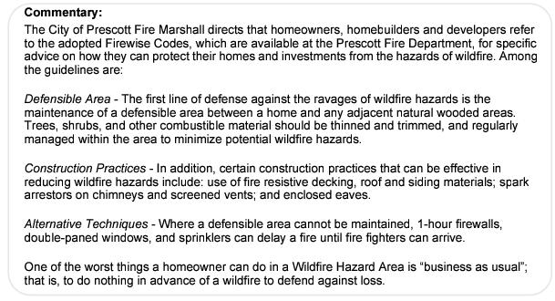
6.10.3 / Wildfire Hazard Mapping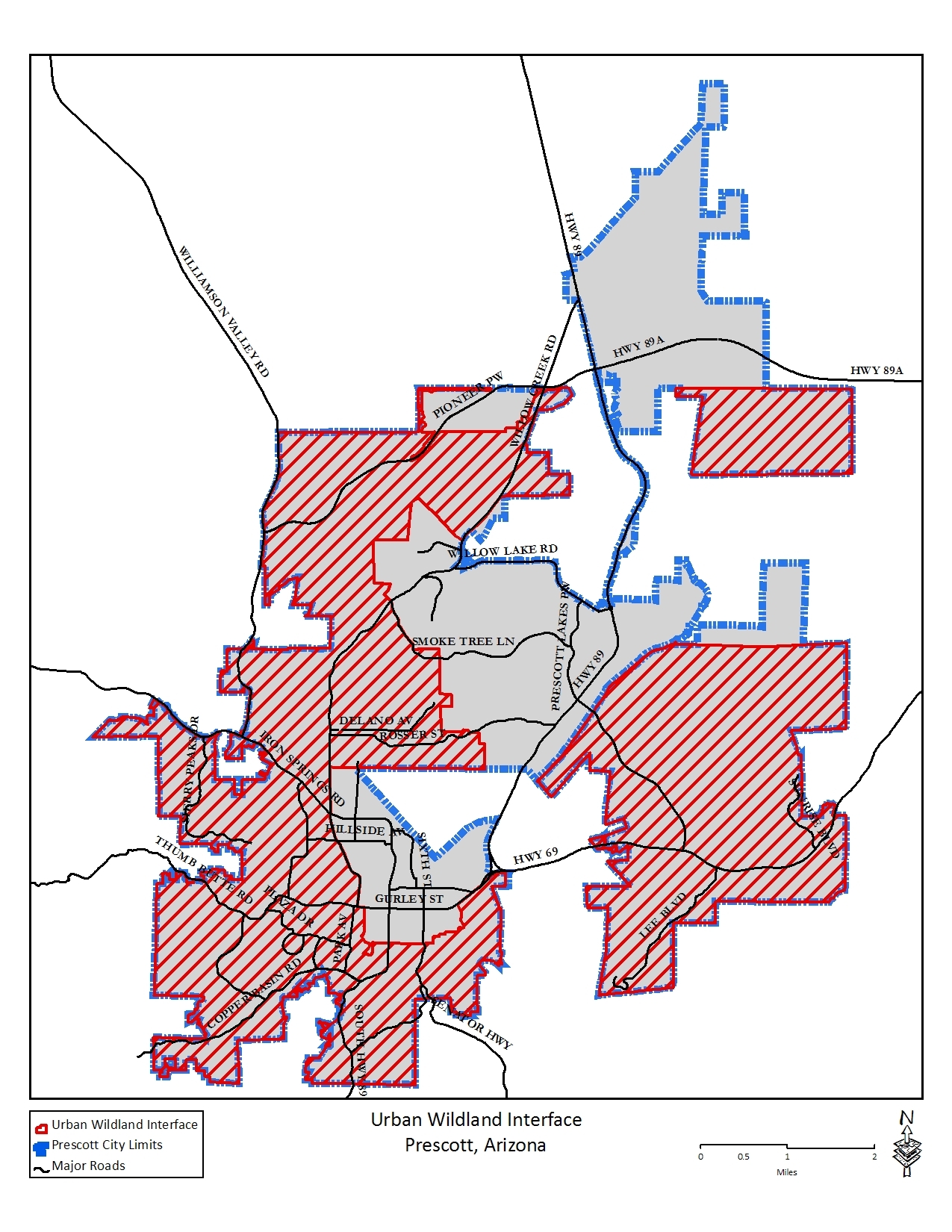
Sec. 6.11 / Outdoor Lighting
This section is intended to accomplish the following:
A. Minimize light pollution and light trespass for the enjoyment and use of property and the night environment;
B. Encourage the use of types, kinds, construction, installation and uses of outdoor luminaries, lighting practices and systems which will reduce light pollution and light trespass, and conserve energy;
C. Encourage the use of quality materials, methods and designs;
D. Benefit astronomical research and observations; and
E. Increase nighttime visibility, utility, security and productivity by limiting levels of illumination, encouraging even illumination and reducing glare.
The Community Development Director or designee may approve alternatives to these standards that meet or exceed the specific requirements of this Section pursuant to the requirements of Sec. 9.16, Administrative Adjustments. Whenever the phrase “meets the intent of this Section” is used in this Section, that shall mean that the proposed use, method or alternate is deemed by the Community Development Director to meet or exceed the specifications and/or requirements of this section.
This Section shall apply to new development, including all new buildings, new parking lots and new outdoor luminaries installed or constructed after the adoption of Ordinance No. 3644A [July 8,1997], except as exempted below.
The following exemptions shall apply as specified.
A. Permanent Exemptions
1. Single Family and Duplexes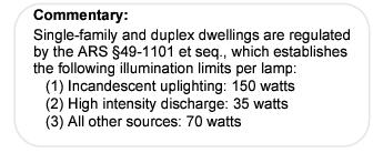
a. Single-family and duplex dwelling lighting are exempt from the requirements of this Section, provided that such exemption shall not apply to recreational lighting uses associated with single-family and duplex dwellings, such as, court lighting, swimming pool lighting, decorative lighting, landscape lighting, and walkway lighting.
b. Security lighting associated with single family and duplex dwellings activated by motion detectors are exempt from the requirements of this Section, provided that such lighting is properly adjusted to turnoff when the detected motion ceases and the motion detector and lighting fixtures are not directed beyond a property line.
2. Existing Luminaries
Replacement of lamps in luminaries that are existing and installed as of the adoption of Ordinance No. 3644A [July 8, 1997] are exempt from the requirements of this Section.
3. Fossil Fuel Lights
All outdoor light fixtures producing light directly by combustion of fossil fuels (such as kerosene lanterns and gas lamps) are exempt from the requirements of this Section.
4. Holiday Decorations
Lighting used for Federal recognized holiday decorations are exempt from the requirements of this Section.
5. Flag Lighting
Lights used for illumination of the American flag or Arizona State flag are exempted from the time of operation where no more than 2 lamps are used to light such flag.
6. Airport Lighting
Airport lighting required for safe and efficient movement of aircraft during flight, take-off, landing and taxiing. All other outdoor lighting at airport facilities shall comply with the light trespass provisions of Sec. 6.11.5A.
7. Public or Municipal Outdoor Recreational Facilities
Lights used for illuminating public or municipal outdoor recreational facilities are exempt from these regulations, provided that illumination shall conform to the IESNA (Refer to Sec. 6.11.10, Definitions) recommended practices. This exemption shall not be interpreted as exempting such from the provisions of Sec. 6.11.5, Light Trespass and Glare.
B. Temporary Exemptions
Temporary use permits may be approved pursuant to the provisions of Sec. 9.11, Temporary Use Permits, for any situation that is not allowed by this Section where temporary lighting is required, including but not limited to, special civic or public events, sporting events, special business events, grand openings of businesses, and construction projects (see also Sec. 2.6.1P).
1. Information Required
Applications for temporary lighting exemptions shall be submitted in accordance with the requirements of Sec. 9.11.1A, Submittal Requirements, and shall include the following:
a. Name, address and telephone number of the applicant;
b. Location of the outdoor light fixtures for which the exemption is requested;
c. Specific exemption(s) requested;
d. Use of the outdoor light fixtures involved;
e. Duration of the requested exemption(s);
f. Type of outdoor light fixture(s) to be used, including total lumen output, mounting, aiming and character of the shielding, if any;
g. Previous temporary exemptions for that location, if any;
h. Justification for the exemption, and;
i. Such other relevant data and information as may be required by the Community Development Director.
2. Duration of Approval
The permit shall be valid for not more than 60 consecutive days from the date of assurance of approval. Exemptions are renewable for a period of not more than 15 consecutive days. However, the Community Development Director upon good cause can extend the time for construction projects, not to exceed the contemplated completion date of said project. Requests for renewal of a temporary exemption shall require an additional filing fee.
C. Emergency Exemptions
This Section shall not apply to portable temporary lighting used by law enforcement, emergency services personnel or public utilities to protect life or property.
6.11.4 / Outdoor Lighting Types
All illumination designed or placed so as to illuminate any portion of a site shall be achieved in accordance with the following standards: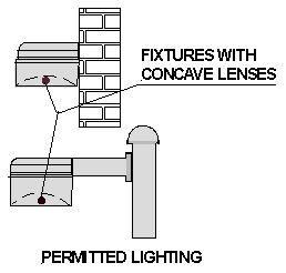
A. General
All types of outdoor lighting shall be subject to the following standards, except as specifically exempted herein:
1. Outdoor lighting shall utilize cut-off fixtures as defined by Sec. 6.11.10;
2. Illumination levels shall conform to the IESNA (Refer to Sec. 6.11.10) recommended practices; and
3. Outdoor lighting shall be subject to the requirements of Sec. 6.11.5, Light Trespass and Glare.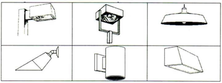
EXAMPLES OF ALLOWED COMMERCIALLY AVAILABLE LUMINARIES
B. Outdoor Retail, Recreational and Other Lighting
1. Single-family and duplex residential recreational lighting uses, such as court lighting and swimming pool lighting shall comply with the requirements of this section.
2. Notwithstanding the provisions of Sec. 6.11.4A.1 to the contrary, lights used for internally illuminated signs do not have to utilize cutoff fixtures. To limit undesirable light pollution, however, such signs (including but not limited to awning/canopy signs, cabinet signs, changeable copy panels or service station island signs) shall use the preferred dark or opaque sign face with translucent letters and symbols, which may be night bright colors. White or other night-bright colors are not permitted as background colors, unless where a site shall be limited to 80 watts cumulative exterior lighting.
3. Except for exposed neon lighting, the source of illumination for sign structures shall be so oriented or shielded so that the source of illumination shall not be visible from any residential zoned property or any public thoroughfare. Sign placement shall be in accordance with the sign illumination requirements of Sec. 6.12.12B.
4. The source of illumination for any sign shall be oriented or shielded so that the source of illumination shall not be visible from any residential use or public thoroughfare, provided, however, this limitation shall not apply to neon and traditional holiday lighting.
5. Top-mounted fixtures are required for outdoor advertising displays and exterior lighted signage when total sign wattage exceeds 150 watts.
C. Decorative, Landscaping and Walkway Lighting
All decorative, landscaping and walkway lighting shall be selected, installed, and aimed so as to minimize the amount of light beyond the area intended to be lighted.
1. Maximum Illumination Levels
Illumination levels shall be limited as follows:
a. Incandescent up-lights shall not exceed 150 watts per lamp.
b. High intensity discharge shall not exceed 35 watts per lamp.
c. Other light sources shall not exceed 70 watts per lamp.
2. Pole Mounted Luminaries
Pole mounted luminaries shall not be mounted higher than 12 feet.
D. Security Lighting, Nonresidential
Nonresidential security lighting shall comply with the General requirements of Sec. 6.11.4A.
E. Off-Street Parking Lighting
Off-street parking area lighting shall be subject to the following standards.
1. High Pressure Sodium (HPS) sources shall be used to illuminate parking areas; provided; however, other light sources may be used for outdoor retail and recreational uses occurring in a parking lot; e.g., auto dealerships.
2. The average maintained light level on the entire facility’s parking surface shall be in a range from one foot-candle to 3 foot candles. The average-to-minimum uniformity ratio shall not exceed a ratio of 4:1 with a maximum 15 foot-candles.
3. A maximum of 5 maintained foot-candles is permitted within 50 feet of the customer only entrances to commercial buildings that adjoin parking areas. The 50-foot area shall be excluded from the average maintained light level for projects with adjoining parking areas of 250 or more parking spaces.
4. Notwithstanding the provisions of Sec. 6.11.5A.2, the maximum height of lighting fixtures may be extended to 40 feet upon the approval of the Community Development Director where such additional height would be consistent with the purposes of this Section, including, but not limited to:
a. Reduction of glare,
b. Reduction of light poles,
c. Uniformity of lighting, and
d. Mitigation of adverse impacts.
5. The lighting system shall be so designed to produce an average maintained light level on lighted portions of the facility’s parking surface in a range from 0.5 to 3 foot candles. The maximum-to-minimum uniformity ratio shall not exceed 15:1 with a maximum 15 foot candles.
6. Pole mounted fixtures shall be mounted at a maximum height of 18 feet within 50 feet of a property line adjoining residential zoning districts, and a maximum height of 30 feet above grade otherwise.
7. A maximum of 25 percent of the off-street parking luminaries may remain lighted after one hour of the closing time of the business until sunrise.
F. Roofed and Covered Parking Facility Lighting
Roofed and covered parking facilities lighting shall be designed to comply with the recommended practices of the IESNA (Refer to Sec. 6.11.10, Definitions).
G. Public or Municipal Outdoor Recreational Lighting
1. Notwithstanding cutoff fixture requirements of Sec. 6.11.4A.1, field sports luminaries do not have to utilize cutoff fixtures. This provision shall not be interpreted to relieve court sports luminaries from cutoff requirements.
2. Notwithstanding the light trespass requirements of Sec. 6.11.5A.1, below, field sports lighting shall have a maximum of 1.5 foot candles initial maximum vertical luminance 6 feet above grade at the property line and 1 foot candle initial horizontal luminance at the property line. Direct glare shall not be visible beyond 100 feet of a stadium or ballpark boundary.
6.11.5 / Light Trespass and Glare
Light trespass and glare for all lighting types shall be mitigated in accordance with the following requirements:
A. Light Trespass
Light trespass on adjacent properties shall be minimized as follows:
1. All outdoor lighting, other than public and municipal recreational lighting, shall be designed and operated so that no more than an average maintained 0.5 foot-candle is measured on a horizontal plane at grade at the property line adjacent to residential areas, and no more than an average maintained one foot-candle adjacent to all other uses.
2. Pole mounted fixtures shall be mounted at a maximum height of 18 feet within 50 feet of a property line adjoining residential zoning districts, and a maximum height of 30 feet above grade otherwise.
3. Wall-mounted luminaries shall be mounted no higher than 30 feet or the distance to the nearest property line, whichever is less, unless the luminaries are mounted so as to direct the light away from the adjacent property, e.g., on a wall on the property line but directed toward the interior of the subject property. Where luminaries are mounted on a wall with the light directed toward the interior of the subject property, the Community Development Director may approve luminaries mounted up to 40 feet high.
4. Final determination as to compliance with these light trespass and glare requirements shall be based on 10 foot by 10 foot, point-by-point photometric analysis by the Community Development Director. (See Sec. 6.11.8, Submission of Plans and Evidence of Compliance.)
B. Glare
Glare shall be minimized by compliance with the following requirements:
1. All outdoor lighting shall be designed to minimize the impact on sky glow and glare.
2. Glare from any luminaire, except for public or municipal recreational lighting, shall not be visible from 6 feet above grade at the property line.
3. Adjacent property to residential zoned property, decorative, landscape and/or walkway luminaries shall be shielded on the lot line side to eliminate spill and glare.
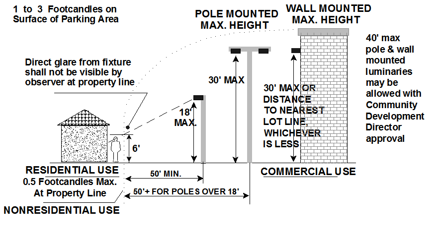
Outdoor lighting shall be off between 10PM and sunrise, except as follows: Advertising signs may be illuminated all night, unless otherwise required by this LDC. 
A. Outdoor retail, commercial, assembly, repair and industrial areas may be illuminated when such areas are actually in use.
B. Public or municipal outdoor recreational lighting may remain lighted past 11PM in order to complete recreational activities that are in progress and under illumination at 11PM.
C. Decorative, landscaping and walkway lighting associated with businesses may be illuminated during their business hours.
D. Security lighting may remain on all night.
E. Flag lighting for American flags or the State of Arizona flag may remain on all night.
F. Time and temperature sign lighting may remain on all night.
G. All off-street parking area lighting shall be dimmed to ¼ of the project’s full illumination lighting plan at 10PM or when the use of the parking area ceases.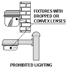
Prohibited lighting includes the following:
A. New Mercury Vapor luminaries for use as outdoor lighting, and existing Mercury Vapor luminaries shall be prohibited after January 1, 2005;
B. Operation of search lights for advertising purposes;
C. Area lights with other than horizontal lenses;
D. Strings of lights over 1 watt each; and
E. Luminaries with dropped, sag or convex lenses lighting, as illustrated at right, are prohibited.
6.11.8 / Submission of Plans and Evidence of Compliance
An outdoor lighting plan evidencing that the proposed work will comply with the requirements of this Section shall be submitted with all building permit applications for land uses, not specifically exempted pursuant to the provisions of Sec. 6.11.3, Exemptions.
A. All outdoor lighting plans shall include at least 2 complete sets of the following:
1. The location of the site where the outdoor luminaries will be installed;
2. Plans indicating the location, mounting height, and type of all luminaries, both existing and proposed, on the premises;
3. Point-by-point lighting level printouts with calculation areas delineated when the services of a professional electrical engineer are required or when required by the Community Development Director; and
4. A description of the outdoor light fixtures including, but not limited to, manufacturer’s catalog cuts, photometric report with candela distribution, drawings, and shielding information.
B. The required plans and descriptions shall be sufficiently complete to enable the City to determine readily whether compliance with the requirements of this Section will be achieved. If such plans and descriptions cannot enable this determination due to the nature or configuration of the devices, fixtures or lamps proposed, the applicant shall submit further evidence of compliance enabling such determination.
C. If required by the Community Development Director, a licensed Professional Engineer shall seal submittals and drawings. Submittal must contain the name of the company that prepared the drawings and the name, title and telephone number of the person that performed the design work.
D. All projects requiring a licensed professional electrical engineer shall be submitted with fully engineered drawings.
E. All parking lot projects requiring a licensed electrical engineer shall be submitted with an engineered lighting plan showing point-by-point lighting levels for the entire lot with a maximum of 10 feet x 10 feet spacing of calculation points. Light loss factors shall be used as follows:
1. High Pressure Sodium: 0.81
2. Metal Halide: 0.72
F. If required by the Community Development Director, projects re-submitted for approval shall include a written description of all changes, with comments keyed and attached to the plan check comments, and sealed by a licensed Professional Engineer.
6.11.9 / Permits and Installation
A. If required by the International Electrical Code, an electrical permit and inspection by the City shall be required for all new and replacement external luminaries, provided however that a permit and inspection are not required for single family and duplex dwellings. Notwithstanding the foregoing, the City reserves the right to inspect single family and duplex dwellings to determine compliance with this Section.
B. The owner or contractor of record shall install the approved outdoor lighting fixtures in conformance to the listing, manufacturer’s installation specifications, and all applicable local building and electrical codes.
6.11.10 / Outdoor Lighting-Related Definitions
Outdoor lighting-related terms shall have the following meanings as used in this Section:
|
OUTDOOR LIGHTING - RELATED DEFINITIONS |
|
|---|---|
|
Term |
Definition |
|
Advertising Display |
Advertising structures and signs used for outdoor advertising purposes, not including on-premise advertising signs. |
|
Candle / Candela |
Unit of luminous intensity. |
|
Cutoff Fixtures |
Outdoor luminaries shielded or constructed so that the light rays emitted by the fixture are projected below a horizontal plane passing through the lowest point on the fixture from which light is emitted, and the candlepower per 1000 lumens does not numerically exceed 25 (2.5%) at an angle of 90°above (nadir) horizontal, and 100 (10%) at a vertical angle of 80°above nadir. Drop or sag lens type fixtures shall not be allowed because of glare. |
|
Decorative, Landscape and Walkway Lighting |
Outdoor lighting used for decorative, landscape and/or walkway effect; e.g., illumination of landscaping, flags, fountains, plants, statues, walkways, and building facades. |
|
Direct Glare |
Glare resulting from the lamp being visible in the field of view. |
|
Foot Candle (FC) |
Foot candle (FC) is the commonly used measure of light level by the IESNA. It is the luminance on a surface one square foot in area on which there is a uniformly distributed flux of one lumen, or the luminance produced on a surface all points of which are at a distance of one foot from a directionally uniform point source of one candela. It is the luminous flux per unit area in the Imperial system. One foot candle equals approximately 0.1 (0.093) lux. |
|
Glare |
The sensation provided by luminance within the visual field that is sufficiently greater than the luminance to which the eyes are adjusted to cause annoyance, discomfort or loss in visual performance and visibility, and public health and safety issues, as it may cause vehicular or other accidents. |
|
Grade |
The average of the native ground level or the finished ground level measured at the center of all walls of the building or the adjoining parking area, whichever is closer. The height of berming and the mounding of dirt on which a light pole is placed shall be counted in the overall height of the pole. |
|
IESNA |
Illuminating Engineering Society of North America, New York, NY. |
|
Light Pollution |
any artificial light that is emitted into the atmosphere either directly or indirectly by its reflection off of dust, water vapor and other atmospheric pollutants in the sky, and that adversely impacts astronomical research and enjoyment of clear night skies. |
|
Light Trespass |
Any artificial light that causes unwanted light on adjacent properties. |
|
Lumen |
Unit used to measure the actual amount of visible light which is produced by a lamp as specified by the manufacturer. |
|
Luminaire |
A complete lighting unit consisting of a lamp or lamps, together with the parts designed to distribute the light, to position and protect the lamps and to connect the lamps to the power supply. |
|
Lux |
A unit of illumination equal to the direct illumination on a surface that is everywhere one meter from a uniform point of source of one candle intensity or equal to one lumen per square meter. |
|
Motion Detector |
A Luminaire designed to illuminate an area around a residence or other building by means of switching on a lamp when motion is detected inside the area or perimeter and switching the lamp off within a set period of time when the motion ceases. |
|
Night Bright Colors |
Translucent colors that permit excessive transmission of light and light trespass. Colors identified as “night-bright” shall be based upon the Gerber High Performance Series Specguide, or other comparable colors provided by other similar product suppliers that provide color swatches of vinyl products available for Plexiglas sign faces. Individual colors identified on the aforementioned Specguide as White, Clear, Ivory, and Egg Shell, Oyster, Palm Oyster, Pearly Grey, Powder Blue, and Robin Egg Blue shall be deemed as “night-bright” colors. |
|
Off Street Parking Lighting |
Lighting for all off-street parking except single-family detached or duplex residential uses. |
|
Outdoor Luminaire |
An outdoor artificial illuminating device, installed or portable, used for flood lighting, general illumination or advertisement. Such devices shall include, but are not limited to, search, spot and flood lights for buildings and structures, recreational facilities, parking lots, landscape lighting, outdoor advertising displays and other signs for advertising or other uses, street lighting, walkway lighting, product display area lighting and building overhang and open canopies. |
|
Outdoor Luminaire, Approved |
Lighting fixtures and lamps approved by the Community Development Director as conforming to the requirements of this Code or meeting the intent of this section. |
|
Outdoor Retail, Recreational, and Other Lighting |
Outdoor lighting used for outdoor retail or restaurant areas, automotive dealers (display areas only), assembly or repair areas, gasoline pump or similar canopy lighting, outdoor advertising displays, private outdoor recreational areas and similar applications. |
|
Parking Area |
An area, other than a street, that is designed primarily for parking of vehicles. |
|
Public or Municipal Outdoor Recreational Lighting |
Lighting for schools, public or city related outdoor recreational facilities. |
|
Recreational Facilities |
Parks, public, municipal or private facilities designed and equipped for the conduct of sports, leisure time activities and other customary and usual recreational activities. Outdoor recreational facilities include, but are not limited to fields or stadiums for softball, baseball, football, soccer, golf courses, driving ranges and other “field sports”; and courts for tennis, basketball, volleyball, handball and other “court sports”. |
|
Security Lighting |
Outdoor lighting used for illumination for equipment yards and outdoor security for the purpose of visual security. |
Sec. 6.12 / Signs
The sign standards are intended to encourage development that is in harmony with the desired character of the City while providing due regard for the public and private interests involved; promote effective use of signage by preventing over concentration, improper placement, and incompatible size; provide an improved visual environment; control light pollution; and prevent the depreciation of property values within the City of Prescott.

Signs may be erected, placed, established, painted, created or maintained only in conformance with the provisions of this section.
The following signs shall be exempt from these standards:
A. Traffic signs on public right-of-way, such as Stop, Yield and similar signs, which meet Department of Transportation standards, and other commercial signage as permitted by the City Code;
B. Any sign inside a building;
C. Directional signs assisting in the flow of traffic, street addresses, or signs necessary for safety (e.g. stop engine, no smoking) that do not exceed 2 square feet in area;
D. Signs located inside windows; however, this shall not be construed to permit otherwise prohibited signs;
E. A sign located on the top or side of an operable, fuel dispensing pump where such sign is not illuminated and not visible from any public rights-of-way; and
F. Governmental flags, where flagpoles are permitted.
6.12.4 / Administrative Adjustments
Notwithstanding other provisions to the contrary, adjustments to these sign standards may not be approved in accordance with the provisions of Sec. 9.16, Administrative Adjustments.
Signs shall be permitted on private property subject to the procedures of Sec. 9.7, Sign Permits and Comprehensive Sign Plans. All signs are subject to the lighting provisions of Sec. 6.11.4.B. Signs shall be subject to the following standards:
A. Permanent On-Site Signs
Permanent on-site signs are permitted in all zoning districts, subject to the following.
1. Freestanding signs for nonresidential districts, except NOS and RS districts:
a. One freestanding sign is permitted per street frontage of a parcel with vehicular access to the site.
b. Each freestanding sign is limited in size based upon the posted speed of the adjacent fronting street:
1) Speed limit up to 25 mph = 24 square feet of sign area;
2) Speed limit 30 to 40 mph = 36 square feet of sign area;
3) Speed limit 45 to 55 mph = 48 square feet of sign area;
4) Speed limits above 55 mph = 100 square feet of sign area.
c. Freestanding signs for commercial or industrial centers may have 6 additional square feet of sign area for each speed category, up to a maximum of 100 square feet.
d. Freestanding signs shall be limited to a height not to exceed 12 feet.
e. Freestanding signs for commercial or industrial centers shall be limited to a height not to exceed 16 feet.
f. Freestanding signs shall be set back from the adjacent property line such that the pole or the center of the support structure shall be a minimum of 5 feet from the property line. No portion of any sign may project over a property line.
g. Freestanding signs shall be placed in a landscaped area equal to the permitted sign area.
h. Drive-through lanes may each have one menu board not exceeding 32 square feet in addition to signs permitted above. The menu board shall be located or screened in such a manner that its content is not readable from off site.
i. Freestanding signs are subject to the lighting provisions of Sec. 6.11.4.B.
2. Building wall signs for nonresidential districts, except NOS and RS districts:
a. One wall-mounted sign is permitted per business on each exterior wall of the building facing a street or containing a customer entrance, up to the maximum area permitted for each business.
b. Wall-mounted signs are permitted up to the following maximum size:
1) For buildings set back 0 to 25 feet from the property line, wall sign area shall be permitted up to 0.5 square foot of sign for each 1 linear foot of wall frontage of the wall upon which the sign is mounted.
2) For buildings set back 26 to 50 feet from the property line, wall sign area shall be permitted up to 1 square foot of sign for each 1 linear foot of wall frontage of the wall upon which the sign is mounted.
3) For buildings set back greater than 50 feet from the property line, wall sign area shall be permitted up to 1.5 square feet of sign for each 1 linear foot of wall frontage of the wall upon which the sign is mounted.
4) Where the property fronts a roadway with posted speed limits over 45 mph, sign area shall be permitted up to 1.5 square feet of sign for each 1 linear foot of wall frontage of the wall upon which the sign is mounted, regardless of setback from property line.
5) Drive-through lanes may each have one menu board not exceeding 32 square feet in addition to signs permitted above. The menu board shall be located or screened in such a manner that its content is not readable from off site.
c. Wall-mounted signs are subject to the lighting provisions of Sec. 6.11.4.B.
3. Freestanding signs for residential districts and private property in NOS and RS districts:
a. Properties in single-family districts are permitted one sign, not exceeding 6 square feet, per street frontage with vehicular access to the site.
b. Properties in multi-family districts are permitted one sign per street frontage with vehicular access to the site as follows:
1) Speed limit up to 25 mph = 24 square feet of sign area;
2) Speed limit 30 to 40 mph = 36 square feet of sign area;
3) Speed limit 45 to 55 mph = 48 square feet of sign area;
4) Speed limits over 55 mph = 100 square feet of sign area.
c. Freestanding signs shall be limited to a height not to exceed 6 feet in single-family zones and not to exceed 12 feet in multi-family zones.
d. Freestanding signs shall be set back from the adjacent property line such that the pole or the center of the support structure shall be a minimum of 5 feet from the property line. No portion of any sign may project over a property line.
e. Freestanding signs shall be placed in a landscaped area equal to the permitted sign area.
f. Freestanding signs are subject to the lighting provisions of Sec. 6.11.4.B.
4. Building wall signs for residential districts and private property in NOS and RS districts:
a. One wall-mounted sign is permitted per building in a single-family district up to 6 square feet.
b. One wall-mounted sign is permitted per building in a multi-family district up to the following maximum size:
1) For buildings set back 0 to 25 feet from the property line, wall sign area shall be permitted up to 0.5 square foot of sign for each 1 linear foot of wall frontage of the wall upon which the sign is mounted.
2) For buildings set back 26 to 50 feet from the property line, wall sign area shall be permitted up to 1 square foot of sign for each 1 linear foot of wall frontage of the wall upon which the sign is mounted.
3) For buildings set back greater than 50 feet from the property line, wall sign area shall be permitted up to 1.5 square feet of sign for each 1 linear foot of wall frontage of the wall upon which the sign is mounted.
c. Wall-mounted signs are subject to the lighting provisions of Sec. 6.11.4.B.
B. Temporary Signs
Temporary signs are permitted on private property in all zoning districts, subject to the following.
1. Temporary signs on private property for nonresidential uses:
a. One temporary sign, of up to 24 square feet, may be permitted per business.
b. A permit shall be required for all temporary signs.
c. Temporary sign permits shall be good for 180 days. A copy of the permit must be maintained on the premises and be readily available upon demand for verification by City inspectors.
d. A temporary sign may be attached to a building wall or may be freestanding. The proposed location, materials and means of attachment or support shall be specified in the permit application.
e. A temporary sign shall be subject to City inspection to assure that the installation is accomplished in a safe manner and location.
f. Damaged or dangerous conditions caused by a temporary sign must be immediately remedied or may result in the revocation of the permit.
g. Failure to obtain a permit for a temporary sign or failure to remove a temporary sign upon expiration of a permit shall constitute a blighting condition upon the property and shall be subject to enforcement and penalties as provided in City Code Chapter 1-3 and/or City Code Section 7-5-20.
2. Temporary signs on private property for residential uses are exempt from permitting, but subject to the following:
a. Each temporary sign shall be limited to not more than 6 square feet.
b. Each temporary sign must be freestanding and installed in a safe and secure manner.
c. Each temporary sign shall be limited to a maximum height of 5 feet.
d. Damaged or dangerous conditions caused by a temporary sign must be immediately remedied or may result in enforcement action by the City.
e. Failure to maintain a temporary sign shall constitute a blighting condition upon the property and shall be subject to enforcement and penalties as provided in City Code Chapter 1-3 and/or City Code Chapter 7-5.
C. Signs in the Public Right-of-Way
See City Code Title VIII.
(Ord. 5015-1553, 11-15-2016)
6.12.6 / Comprehensive Sign Plan Standards
A. Purpose
Comprehensive sign plans regulate the appearance and location of signs within a single large commercial or residential project. Approved comprehensive sign plans may allow additional flexibility including innovative sign design, a greater number of signs, or more sign area than otherwise permitted in this Section. Comprehensive sign plans are expected to result in higher quality signage than is otherwise required.
B. Compliance with a Comprehensive Sign Plan
A comprehensive sign plan may be requested by the owner of properties containing multi-tenant buildings, and multi-occupant, multi-product, or multi-service commercial development. Such development shall be required to comply with a comprehensive sign plan when approved in accordance with the procedures of Sec. 9.7, Sign Permits and Comprehensive Sign Plans, and other applicable requirements of this Code. Such proposals require review by the City’s Planning and Zoning Commission and action by the City Council.
1. Proposed Development
Where requested, a comprehensive sign plan shall be submitted in conjunction with the required site plan.
2. Existing Development
The owner of an existing development seeking a comprehensive sign plan shall submit such plan to the City in conjunction with any addition of gross floor area by 20 percent or more, or for any interior or exterior remodeling that results in the value exceeding 20 percent or more of the building’s value prior to the remodeling.
C. Comprehensive Sign Plan Requirements
A comprehensive sign plan shall not be approved until and unless the City Council finds that:
1. The plan provides that signs of a similar type and function within the development will have a consistent size, lettering style, color scheme and material construction; and the plan provides for signs that meet the size limitations, location requirements and other applicable requirements of this Section; or
2. The plan results in an improved design in exchange for a greater number of signs or larger sign face area than otherwise permitted by this Section.
D. Effect
After approval of a comprehensive sign plan, or an amended comprehensive sign plan, no sign shall be erected, placed, painted, or maintained, except in accordance with such plan, and such plan may be enforced in the same way as any provision of this Code.
(Ord. 5015-1553, 11-15-2016)
6.12.7 / Airside Signage at the Prescott Municipal Airport
For businesses with airside frontage, the following standards shall apply:
A. Applicability
All signage permitted and regulated under this Section shall be restricted to those frontages considered “airside” as defined under this Code (Refer to Sec. 11.2. Terms Defined). For those businesses with airside and landside frontage (Refer to Sec. 11.2), the landside signage shall be computed independently from the airside signage using the sign regulations provided in Sec. 6.12, Signs.
B. Airport Approval
All proposed signs shall have written approval by the Airport Director before a sign is submitted to the City of Prescott for a sign permit. The Airport Director may review signage for its placement on all airside structures and within airside areas, the material used to construct the sign, the type of illumination used, color, size, shape, where/how it is placed, and/or any other pertinent aspect relating to the proposed signage.
C. Maximum Sign Sizes, Wall Mounted
1. Individual Buildings less than 10,000 square feet in size: 50 square feet.
2. Individual Buildings >10,000 square feet or with 75 or more linear feet of airside building frontage, total allowable signage, up to a maximum of 150 square feet, shall be calculated according to the more restrictive of the following alternative criteria:
a. For each additional linear foot of airside building frontage in excess of 75 feet, add one square foot of allowable signage to determine total allowable signage.
[EXAMPLE: 50 sf + (1 sf x no. linear ft. 75 linear ft.) = Sign Area]
b. For each additional square foot in excess of 10,000 square feet of building area, multiply .0050 by the gross floor area (GFA) to determine total allowable signage.
[EXAMPLE: .0050 x (GFA, 10,000 or >) = Sign Area]
3. Businesses within a commercial or industrial center having airside frontage, that are determined by the Airport Director to have a need for signage shall be permitted: 40 sf
4. Additional signage may be authorized, up to a maximum of 150 square feet, according to the more restrictive of the following alternative criteria:
a. For each additional linear foot of airside building frontage in excess of 40 feet: add one square foot of allowable signage to determine total allowable signage.
[EXAMPLE: 40 sf + (1 sf x no. additional ft. >75 linear ft.) = Sign Area]
b. For each additional square foot in excess of 8,000 square feet of building area: multiply .0050 by the gross floor area (GFA) to determine total allowable signage.
[EXAMPLE: .0050 x (GFA, 8,000 or ) = Sign Area]
D. Freestanding Signage Prohibition
Freestanding signage is generally prohibited. However, the Airport Director may provide a written determination indicating that freestanding signage is appropriate. The applicant, upon receipt of this finding, may apply for a Conditional Use Permit (Refer to Sec. 9.3). Freestanding signs shall be subject to the following standards:
1. Area and Projection
a. Maximum Area: 24 sf
b. Maximum Projection From Structure: 48 inches
2. Freestanding signage area shall be included in the signage total for the individual project.
3. No signage is to project beyond any lease lines.
4. All signage shall be subject to Federal Aviation Administration codes and restrictions.
5. All signage shall be subject to the rules and regulations of the Airport.
6.12.8 / Changeable Copy Sign Standards
Changeable copy signage shall be subject to the following development standards:
A. Changeable copy signs are permitted up to a maximum of 50 square feet and shall encompass no more than 50% of the allowable freestanding sign area.
B. Minimum time interval between copy changes is 30 seconds.
C. Transition methods are limited to static message replacement.
D. Allowable brightness is 0.3 foot candles above ambient light conditions. An automatic dimming sensor is required to appropriately adjust brightness.
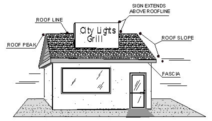
Signs not specifically authorized are prohibited, including but not limited to the following:
A. Roof-mounted signs or signs that project above the highest point of the roofline, parapet, or fascia – see illustration of roofline and fascia features at right;
B. Signs that project above the canopy or awning upon which the sign is attached;
C. Sandwich signs or portable signs, except as specifically within rights-of-way permitted by the City Code within rights-of-way;
D. Signs mounted, attached or painted on trailers, boats, or motor vehicles for advertising purposes when used in place of or as additional advertising at or near the business or activity;
E. Any sign emitting sound;
F. Any sign with intermittent or flashing illumination; animated, moving signs or the illusion of movement; but not to include time and temperature signs;
G. Signs attached to and projecting from the roof or wall of a building perpendicular to a wall surface more than 36 inches, but not including signs mounted perpendicular to a wall entirely under an awning or roof overhang;
H. Signs constructed of open light bulbs; but not including exposed neon; and
I. Billboards and other off-premises signage, unless approved as a part of a comprehensive sign plan.
(Ord. 5015-1553, 11-15-2016)
A. Sign Area
1. Single Sign Face
a. The area of a wall sign or sign with a single face shall be computed by measuring the sum of:
1) Areas contained within the outside dimensions of the background panel; and
2) Any surface material or color that forms an integral part of the sign, or is used to differentiate the sign from the backdrop or structure against which it is placed. Sign face does not include any supporting framework, base, bracing or decorative fence or wall that is clearly incidental to the sign.
b. Signs mounted directly on a wall, without a background, shall be measured by totaling the area(s) of the smallest rectangles that will encompass the extreme limits of each word, graphics, or other display. 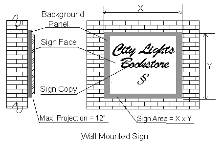
2. Two or More Sign Faces
If the interior angle between the 2 sign faces is 45 degrees or less, sign area will be measured as a single face. If the 2 faces of a double-faced sign are of unequal area, the area of the sign shall be the area of the larger face. In all other cases, the areas of all faces of a multi-faced sign shall be added together to compute the area of the sign.
3. Spherical or Free-Form Signs
Sign area shall be the sum of the area of sides of the smallest 4-sided polyhedron that will encompass the sign structure.
4. Illuminated Signs
a. Sign area shall include the entire illuminated surface, or illuminated architectural element, that contains sign copy or graphics.
b. Back lighted architectural awnings shall count toward the sign allowance when the sign copy is visible at night.
c. Neon banding on a building shall count toward the aggregate maximum signage area.
5. Flags
Flags identifying entities other than governmental, and not approved as temporary or special event signs, shall count toward aggregated sign total.
B. Height
1. Freestanding Signs
Sign height shall be measured as the distance from the top of the sign structure to the finished grade at the base of the sign. The height of any monument base or other structure erected to support a sign shall be measured as part of the sign height.
2. Wall or Fascia Mounted Signs
Sign height shall be measured as the distance from the top of the sign structure to the finished grade at the base of the subject wall.
(Ord. 5015-1553, 11-15-2016)
6.12.11 / Construction and Maintenance Standards
All signs shall be designed, constructed and maintained in accordance with the following standards:
A. Construction Standards
1. All signs shall comply with applicable provisions of the City building and electrical codes.
2. Except for permitted banners, flags, temporary signs and window signs conforming in all respects with the requirements of this Section, all signs shall be constructed of permanent materials and shall be attached to the ground, a building or another structure by direct attachment to a wall, frame or structure.
3. Signs may be attached flat against canopies made of rigid materials; canopies made of non-rigid materials (e.g. canvas) shall only have signs composed of compatible materials (e.g. paint, stitching, and vinyl).
B. Maintenance Standards
All signs shall be maintained in good structural condition, in compliance with all building and electrical codes at all times, and shall be repaired, replaced, or removed to prevent a public hazard, and subject to the following standards
1. A sign shall have no more than 20 percent of its surface area covered with disfigured, cracked, ripped or peeling paint, poster paper or other material.
2. A sign shall not stand with bent or broken sign facing, with broken supports, with loose appendages or struts, that exceeds 15 degrees from vertical.
3. A sign shall not have weeds, trees, vines, or other vegetation growing upon it, or obscuring the view of the sign from the street or right-of-way from which it is to be viewed.
6.12.12 / Visibility Obstructions
A. No signs shall be erected, and there shall be no lighting of signs or premises, so as to obstruct the view of, or be confused with, any authorized traffic signal, notice or control device. Any such signs or light sources shall be removed at the direction of the Community Development Director.
B. No sign shall obstruct visibility in the sight triangle (Refer to 6.3.10, Corner Setbacks and Intersection Visibility).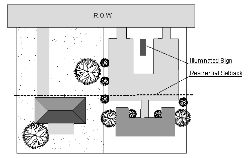
A. All sign illumination shall be subject to the provisions of Sec. 6.11.4B, Outdoor Retail, Recreational and Other Lighting.
B. No illuminated sign structure shall be placed at or behind the existing or required setbacks, whichever is greater, of an adjacent residential lot.
6.12.14 / Sign-Related Definitions
Sign-related terms shall have the following meanings as used in this Section:
|
SIGN-RELATED DEFINITIONS |
|
|---|---|
|
Term |
Definition |
|
Awning |
Same as canopy. |
|
Banner, Temporary |
A sign that is painted or displayed upon cloth or other flexible material. |
|
Canopy |
A shelter or cover projecting from and supported by an exterior wall or building. |
|
Center (Commercial or Industrial) |
A group of 3 or more businesses associated by common agreement or under common ownership with common parking facilities and common freestanding signs. |
|
Landscaping |
Landscaping may include trees, shrubs, ground cover, vines, walkways, ponds, fountains, sculpture and other organic and inorganic materials used for creating an attractive appearance and for the control of erosion and noise and for the separation of pedestrians and vehicles. |
|
Maintenance |
The repairing or repainting of a sign or sign structure; changing of reader panels or directory signs; or renewing copy, which has been made unusable by ordinary wear and tear or weather, is considered maintenance. Reasonable alterations, not including substantial structural replacements, shall be considered maintenance. |
|
Mural |
Murals painted on exterior walls of businesses shall be permitted, subject to review and approval by the Community Development Department to determine that the artistic rendering does not advertise the business in any way, including subject matter or wording, and that the proposed mural is appropriate for the existing use of the building. The Community Development Department may review the background and artistic expertise of the artist based on samples of previous work. Approved murals or artistic renderings shall not be considered as signage. |
|
Roof Line |
The highest point of a structure including parapets, but not to include domes, spires, chimneys or heating or cooling mechanical devices. |
|
Sign |
Any device for visual communication which is used to or intended to attract the attention of the public for business or professional purposes, when the display of this device is visible beyond the boundaries of the property upon which the display is located. The term “sign” shall not include any flag, badge, or insignia of any government or governmental agency. The term “sign” shall not include the displays or advertising devices in a merchant’s window or within the interior of a building. |
|
Sign, Animated |
The movement or the optical illusion of movement of any part of the sign structure, design or pictorial segment including the movement of any illumination or the flashing, scintillating or varying of light intensity. The automatic changing of all or any part of the facing of a sign or any sign or part of a sign set in motion by movement of the atmosphere shall be considered animation. Time and temperature devices shall not be considered as animation under this Code. |
|
Sign, Billboard |
An off-site sign that directs attention to a business, commodity, service, entertainment or product not related to uses on the site where the sign is located. |
|
Sign, Cabinet |
A sign that contains all the text and/or logo symbols within a single enclosed case. |
|
Sign, Canopy |
Any sign erected directly upon a canopy. |
|
Sign, Changeable Copy |
A sign that is capable of regular and routine change of copy, which may be other than the name of the business advertised. There are two types of changeable copy signage permitted: 1) Manual: Utilizes a manual means of changing copy. May or may not be internally illuminated. Also referred to as a reader board or marquee, and 2) Electronic: Utilizes an electronic means of changing copy, either remotely or by automatic means. These signs include, but are not limited to, displays using incandescent lamps, LEDs, LCDs, or a flipper matrix. Also referred to as electronic message centers and electronic message boards. |
|
Sign, Directional |
Public signs erected by or on behalf of a governmental body to convey public information and direct or regulate pedestrian or vehicular traffic. |
|
Sign, Directory |
Any sign listing the names, uses and/or location of the tenant’s businesses or activities conducted within a building or group of buildings. A sign designed to show the relative locations of the several business establishments within a shopping center or other multi-tenant development. |
|
Sign, Fascia |
A sign that is located on the horizontal piece covering the joint between the top of a wall and the projecting eaves of the roof. |
|
Sign, Free-Standing |
A sign which is erected on its own self-supporting permanent structure, detached from any supporting elements of a building. |
|
Sign, Identification |
A sign that directs attention to a business, commodity, service, entertainment or product related to uses on the site where the sign is located and which is not otherwise defined in this article. |
|
Sign, Illuminated |
A sign whose surface is lighted internally or externally. |
|
Sign, Nonconforming |
Any sign that is not allowed under this Code, but which, when first constructed, was lawful. |
|
Sign, Parapet and Mansard |
A sign permanently affixed to a wall or surface that is designed to protect the edge of a roof. |
|
Sign, Projecting |
Any sign attached to a building or other structure and extending in whole or in part more than 12 inches beyond the building. |
|
Sign, Roof |
A sign erected in any way upon a building or structure that extends above the roof line of the building or structure. |
|
Sign, Structure |
The supports and framework of the sign. |
|
Sign, Temporary |
Any sign not intended for permanent display as authorized in Sec. 6.12.5, Permitted Signs. |
|
Sign, Wall-Mounted |
A sign mounted flat against, projecting less than 12 inches or painted on the wall of a building or structure with the exposed face of the sign in a plane parallel to the face of said wall. |
|
Signage, On-Site |
An attached or freestanding sign, which correctly identifies a business, commodity, service or product conducted, sold or offered on the same premises where the sign is located. |
|
Signage, Pan-Channel |
An individual letter that is 3-dimensional and is constructed by means of a 3-sided metal channel. |
(Ord. 5015-1553, 11-15-2016)
Sec. 6.13 / Residential Protection Standards
The Residential Protection Standards of this Section are intended to preserve and protect residential uses and neighborhoods by ensuring that new development and redevelopment is sensitive to the character of development in adjacent zoning districts.
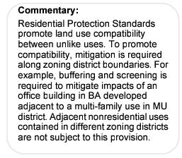
Residential Protection Standards shall apply to all multi-family residential and/or nonresidential development when: (1) it occurs adjacent to residential property; and, (2) the residential property is located in a more restrictive zoning district.
6.13.3 / Dumpsters and Solid Waste Receptacles Setbacks
Dumpster and solid waste receptacles shall be setback at least 20 feet from the lot line of property of any property located in a more restrictive zoning district.
6.13.4 / Buffering and Screening
Buffering and screening shall be required as follows:
A. Buffering and screening shall be provided along property boundaries. The size and density of buffers and screens shall be based on the building height of the more intensive use.
B. Where new development occurs adjacent to vacant land, the buffer yard shall be provided based on existing zoning.
|
BUFFERING AND SCREENING REQUIREMENTS |
||
|---|---|---|
|
Type of Use Adjacent-to-Zoning (Based on Unlike Zoning Districts) |
Building & Parking Full-Width Buffer (With 50 percent Screening) |
Building and Parking Half-Width Buffer (With 80% Screening) |
|
Multi-Family Residential-to-Single-family Residential |
Equal to height of building |
Equal to ½ height of building |
|
Commercial-to-Residential |
Equal to height of building |
Equal to ½ height of building |
|
Commercial-to-Commercial |
No buffer yards are required but dumpsters and loading areas shall be screened from streets and from customer entrance views |
No buffer yards are required but dumpsters and loading areas shall be screened from streets and from customer entrance views |
C. Buffering and Screening Treatments
Required buffer yards must provide adequate landscaping to create an attractive screen within the buffer yard, as viewed from the adjacent residential property at a lateral elevation. Refer to Sec. 6.5.5C. Buffer yards shall be installed prior to certificate of occupancy. Required buffer yards may be reduced where enhanced screening is provided as described below:
1. Full-Width Buffers Require 50 Percent Screening
The buffer shall include one low-to-medium height, spreading tree per 30 linear feet and one tall growing shrub per 100 square feet of buffer yard. Evergreen trees and shrubs are appropriate to consider. Alternatives to this standard may be approved based on species, sizes, quantities and placement sufficient to meet this intent. The intent is to form moderately dense hedges with shrubs and to have trees grow close to one another.
2. Reduced Buffers Require 80 Percent Screening
Buffer yard widths may be reduced by half where the screening is increased by incorporating one of the following enhanced screening techniques:
a. Plants
1) A minimum of one low-to-medium height, spreading tree per 30 linear feet of buffer, plus one tall growing shrub for every 50 square feet of buffer area.
2) Alternative plantings may be approved based on trees and shrub species, size, density and placement sufficient to achieve an 80 percent screen.
b. Berms and Plants
1) Berms shall have crowns with minimum widths of 2 feet and slope gradients less than 2:1.
2) Berms along front and side property lines to the front of buildings shall be no higher than 3 feet, and elsewhere no higher than 6 feet.
3) Plants shall provide 50 percent screening.
c. Masonry Walls and Plants
1) Walls shall be subject to the provisions of Sec. 6.3.10 constructed to a height of no greater than 4 feet, and enhanced with plantings along front and side property lines to the fronts of buildings, and 6 feet in height along other side and rear property lines.
2) Plantings with one tree per 40 linear feet and medium height shrub per 100 square feet of buffer area are required on the residential side of the wall.
3) Finished block and concrete walls, and those made of stone or brick are preferred. Prohibited materials for screening walls include wood, metal, unfinished concrete or concrete block and manufactured materials such as fiberglass.
4) Where commercial service areas adjoin residential properties or streets, a buffer comprising a combination landscape berm and masonry walls up to 10 feet in height shall be permitted, provided, however, that not more than 6 feet of such wall is visible above the berm from the adjoining residential property. On the commercial side of such a treatment, walls exceeding 10 feet in height may be possible subject to review and approval by the Community Development Director.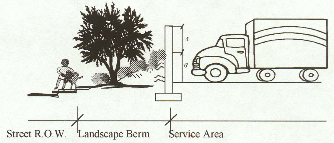
5) Raising or lowering of parking lot grades and other unsightly features relative to the elevation of adjacent properties and streets may be required to aid in obscuring the view of parked vehicles.
6) Natural features such as boulders, rock outcroppings and vegetated drainages, and the natural terrain, may also be used to help screen unsightly features.
D. Buffer Yard Waivers
The Community Development Director may approve buffer yard reductions where required screening is increased from 50 percent to 80 percent. Additional reductions to a commercial buffer yard width and plantings may be also permitted where a public trail is provided per adopted plans or where topographic conditions naturally serve as an effective buffer.
Sec. 6.14 / Traffic Impact Analysis
This article provides uniform guidelines for conducting traffic impact analyses for proposed development with access to an arterial or a collector street.
The City Engineer shall determine applicability based on, but not limited to, the following:
A. A Traffic Impact Analysis (TIA) shall be prepared for proposed developments, or additions to existing developments, that generate more than 100 vehicle trips during the morning or afternoon peak hour period. The City shall make the final determination regarding TIA requirements and applicable category, and the impact analysis shall be in a format as described in Appendix B. The criteria for each TIA category are as follows:
1. Category 1
a. Developments that generate between 100 to 500 trips, during the morning or afternoon peak hour; or
b. Existing traffic situations or concerns in the local area such as, but not limited to, an offset intersection or a high number of traffic accidents; or
c. Sensitivity of the adjacent neighborhoods or other areas where the public may perceive an adverse impact; or
d. Proximity of site driveways to other driveways or intersection; or
e. Specific problems or concerns that may be aggravated by the proposed development.
2. Category 2
Developments that generate 501 to 1,000 total trips during the morning or afternoon peak hour.
3. Category 3
Developments that generate more than 1,000 trips during the morning or afternoon peak hour.
B. In addition to the above requirement thresholds, the Public Works Department may require a TIA when changes in land use, traffic, and roadways occur, such as:
1. Proposed property rezoning; or
2. When the original TIA is more than 2 years old; or
3. Where the projected traffic volumes increase by more than 10 percent.
6.14.3 / Engineering Qualifications
The TIA shall be prepared under the direction of a Professional Engineer (Civil) licensed to practice in the State of Arizona with specific experience in traffic engineering and the preparation of TIA reports. There shall be no deviation from these requirements.
A. Initial Evaluation
Prior to beginning the TIA, the applicant shall contact the Public Works Department to discuss the scope of work, methodology, and level of detail required for the specific project. Following the initial meeting, the applicant shall provide an estimate of the number of vehicular trips generated by the proposed development. The estimate must be prepared using a City-approved methodology and shall be submitted to the City for review and approval. The developer may request that the City assist in estimating the number of trips.
B. Draft Outline
Following the initial evaluation, the City shall make a final determination regarding the need for a TIA and identify the applicable category. If a TIA is required, the applicant shall prepare a draft table of contents and project outline for submittal to the City. The outline will identify the proposed area of influence for the study, all intersection and roadways to be analyzed, and level of detail and methodology for gathering traffic volume information and preparation of level of service analyses. The draft shall also include a proposed trip distribution for site traffic. Following City review and approval the final TIA may be prepared.
C. Scope of Work
The TIA Scope of Work agreement between engineer and developer shall conform to the pre-approved draft table of contents and outline. The findings, conclusions and recommendations contained within the TIA document shall be prepared in accordance with appropriate professional Civil Engineering practices. (See Appendix B for Traffic Impact Analysis format.)
6.14.5 / Analytical Methodology
The procedures outlined in this policy provide the minimum requirements for a TIA, although the City reserves the right to require additional information. The TIA approach and methods shall be guided by the following criteria:
A. Study Area and Timeframe
The minimum study area and timeframe for projected analysis shall be determined by project type and size, in accordance with the criteria previously outlined. The study area or projected timeframe may be amended by the City as necessary.
1. Category 1
The minimum study area shall include all site access drives and adjacent signalized intersections and/or major un-signalized street intersections. The study’s projected timeframe shall be one year from receipt of Certificate of Occupancy.
2. Category 2
The minimum study area shall include all site access drives and all signalized intersections and/or major un-signalized street intersections within 1/2 mile of the development. The study’s projected timeframe shall include the 1st year following receipt of Certificate of Occupancy and the 5 succeeding years.
3. Category 3
The minimum study area shall include all site access drives and all signalized intersections and/or major un-signalized street intersections within 1/2 mile of the development. The study’s projected timeframe shall include the opening year of the development, 5 years after opening and 10 years after opening.
B. Peak Hour Analysis
Both the morning (7AM to 9AM) and evening (4 PM to 6 PM) weekday peak hours shall be analyzed, unless the proposed project is expected to generate no trips, or a very low number of trips, during either peak hours. When a project’s traffic generation patterns differ significantly from established patterns or when the peak traffic hours occur during a different time, all additional peak hours shall be analyzed.
C. Seasonal Adjustments
When directed by City, in cases where seasonal traffic data is available, the traffic volumes for the analysis hours shall be adjusted for the peak season.
D. Data Collection Requirements
All data shall be collected in accordance with procedures outlined in the latest edition of the Institute of Transportation Engineers (ITE) Manual of Traffic Engineering Studies, or as otherwise directed by City. At a minimum, the following data shall be collected:
1. Turning Movement Counts
Manual turning movement counts shall be obtained for all existing cross-street intersection to be analyzed during the morning and afternoon peak periods. Turning movement counts may be required during other periods as directed by the City.
2. Daily Traffic Volumes
The current and projected daily traffic volumes shall be presented in the report. If available, daily count data from the City may be extrapolated a maximum of 2 years with the concurrence of the City. Where daily count data is not available, mechanical counts will be required at locations agreed upon by the City.
3. Collision Data
Collision data shall be obtained for the most current 3-year period available.
4. Roadway and Intersection Geometrics
Roadway geometric information shall be obtained. This includes, but is not limited to, roadway width, number of lanes, turning lanes, vertical grade, location of nearby driveways, and lane configuration at intersections, sight visibility and horizontal alignment.
5. Traffic Control Devices
The location and type of traffic controls shall be identified.
E. Trip Generation
1. The latest edition of the ITE Trip Generation Manual shall be used to identify trip generation rates. In cases where Trip Generation does not include trip rates for a specific land use category, and includes only limited data; or, where local trip rates have been shown to differ from the ITE rates, other rates may be used with the approval of the City.
2. A trip generation table shall be prepared showing proposed land use, trip rates, and vehicle trips for daily and peak hour periods and appropriate traffic volume adjustments, if applicable. Site traffic generation shall be shown for daily, morning and evening peak hour periods. Adjustments made for “passer-by” and “mixed-use” traffic volumes shall follow the methodology outlined in the latest edition of the ITE Trip Generation Manual. The “passer-by” traffic volume discount for commercial centers shall not exceed 25 percent unless approved by the City.
F. Trip Distribution and Assignment
1. Projected trip volume shall be distributed and added to the projected non-site traffic on the roadways and intersection(s) in the study area. The specific assumptions and data sources used in deriving trip distribution and assignment shall be documented in the report.
2. Future traffic volumes shall be estimated using information from transportation models, or applying an annual growth rate to the base-line traffic volumes. The future traffic volumes shall correlate to the project’s specific timeframe. If the annual growth rate method is used, the City must give prior approval to the percentage used.
3. In addition, any nearby proposed or approved development projects shall be taken into consideration when forecasting future traffic volumes. The increase in traffic from proposed and approved developments, the application of an annual growth rate, or a combination of an annual growth rate and proposed and approved developments, shall be used to forecast the future traffic volumes.
4. The site-generated traffic shall be assigned to the street network in the study area based on the approved trip distribution percentages. The site traffic shall be combined with the forecast traffic volumes to show the total traffic conditions estimated at development completion. The total daily and peak period turning movement volumes for each traffic study intersection is required. In addition, the base-line volume with site-generated traffic added to the street network must also be shown. This amount will represent site-specific traffic impacts on existing conditions.
G. Internal Circulation
1. Parking lot/on-site traffic circulation shall be in conformance with standards of practice as set forth by “Transportation and Land Development” (ITE, current edition).
A. Capacity Analysis
1. Level of service (LOS) shall be computed for signalized and un-signalized intersections in accordance with procedures contained in the latest edition of the Highway Capacity Manual.
2. The intersection LOS shall be calculated for each of the following conditions (if applicable):
a. Existing peak hour traffic volumes (“figure” required);
b. Existing peak hour traffic volumes including site-generated traffic (“figure” required);
c. Future traffic volumes not including site traffic (“figure” required);
d. Future traffic volumes including site traffic (“figure” required); and
e. LOS results for each traffic volume scenario (“table” required).
3. The LOS table shall include LOS results for all peak periods analyzed. The table shall show LOS conditions with corresponding vehicle delays for signalized intersections, and LOS conditions for the critical movements at un-signalized intersections. For signalized intersections, the LOS conditions and average vehicle delay shall be provided for each approach and the intersection as a whole.
4. Unless otherwise directed by the City, the capacity analysis for existing signalized intersections shall be conducted using the Highway Capacity Manual Planning Method for each study horizon year.
B. Operational Analysis Method
When directed by City, the capacity analysis shall be conducted using the Operational Analysis Method. If an operational capacity analysis method is used for an existing signalized intersection, it shall include existing phasing, timing, splits, and cycle lengths as observed and measured during the peak traffic periods. For un-signalized intersections, the Highway Capacity Manual methodology shall be used.
C. Phased Projects
Where new development is to be completed in phases, the TIA shall, if directed by City, include an LOS analysis for each separate development phase in addition to the TIA for the overall project timeframe. The incremental increases in site traffic from each phase shall be included in the LOS analysis for each preceding year of development completion. A “figure” will be required for each horizon year of phased development.
D. Traffic Signal Analysis
Traffic signal needs studies shall be conducted for all proposed signals for the base year. If the warrants are not met for the base year, they shall be evaluated for each year in the 5-year horizon. Traffic signal needs studies shall be conducted by a method pre-approved by the City.
E. Collision Analysis
An analysis of 3-year collision data shall be conducted to determine if the level of safety will deteriorate due to the addition of site traffic.
F. Vehicle Speed Parameters
Vehicle speed is used to estimate safe stopping and cross corner sight distances. The posted speed limit is representative of the 85th percentile speed and may be used to calculate safe stopping and cross corner sight distances, unless directed otherwise by the City.
G. Pedestrian and Biking Analysis
The pedestrian and bike facilities, or lack thereof, within the study area shall be analyzed, with and without the proposed development, to identify any projected impacts on their use and safety. Pedestrian and bike use and safety within the study area shall not be unreasonably reduced, with the overall objective being to enhance rather than reduce biking and walking activities.
H. Roadway Improvement Analysis
The roadways and intersections within the study area shall be analyzed, with and without the proposed development, to identify any projected impacts on both level of service and safety. Where the highway will operate at Level of Service “C” or better without the development, the traffic impact of the development on the roadways and intersection within the study area shall be mitigated to Level of Service “C”. Mitigation to Level of Service “D” may be acceptable with City approval. Particular attention shall be directed to potential need for separate right turn or left turn lanes. A section of the TIA shall provide discussion regarding this requirement.
The City may require City streets (improved and unimproved) to be improved and/or widened based on a Traffic Impact Analysis (TIA) and condition of roads. A core sample analysis may be required to determine if the existing structural section and roadway condition is adequate for the proposed level of service. Existing street improvements may require 25’ cross-sections shown on plans.
I. On-Site Circulation Analysis
The TIA shall include an analysis of the adequacy of the on-site circulation plan.
Specific requirements for TIA formats are located in Appendix B, and are based upon the type of TIA. Deviations from format requirements must receive prior approval of the City.