


Chapter 18.35
OVERLAY DISTRICT REGULATIONS – MINERAL RESOURCE LANDS, CRITICAL AREAS, OPEN SPACE CONSERVATION, AIRPORT, AND FAIRGROUNDS
Sections:
Article I. General Provisions
18.35.005 Overlay districts – Purpose.
18.35.010 Overlay districts – Maps.
Article II. Specific Districts
18.35.015 Mineral resource lands district.
18.35.020 Critical areas – Purpose.
18.35.025 Critical areas – Applicability.
18.35.030 Critical areas – General exemptions.
18.35.035 Critical areas – Reasonable use exception.
18.35.040 Critical areas – Mitigation requirements.
18.35.045 Critical areas – Existing legally established structures, uses, and activities.
18.35.050 Critical areas – Nonconforming structures, uses, and activities.
18.35.055 Geologically hazardous areas – Applicability.
18.35.060 Geologically hazardous areas – Identification and classification.
18.35.065 Geologically hazardous areas – Protection standards.
18.35.070 Geologically hazardous areas – Geotechnical reports.
18.35.075 Frequently flooded areas.
18.35.080 Critical aquifer recharge areas.
18.35.085 Wetlands – Applicability.
18.35.095 Wetlands – Minimum size thresholds for regulated wetlands.
18.35.100 Wetlands – Protection standards.
18.35.105 Wetlands – Determination of wetland boundary and requirements for wetland reports.
18.35.110 Fish and wildlife habitat conservation areas – Applicability.
18.35.120 Fish and wildlife habitat conservation areas – Maps.
18.35.125 General protection standards for all FWHCAs.
18.35.130 Protection standards for aquatic fish and wildlife habitat conservation areas (FWHCAs).
18.35.145 Open space conservation overlay district.
18.35.150 Airport overlay district.
18.35.155 San Juan County fairgrounds overlay district.
Article I. General Provisions
18.35.005 Overlay districts – Purpose.
Overlay districts provide regulations in addition to those of other sections in this code for certain land areas and for uses which warrant specific recognition and management. See the official maps for the location of the overlay districts. Except as otherwise provided in the specific overlay district regulations, the provisions of an overlay district shall prevail over any conflicting provisions of this code for the duration of the overlay district, subject to RCW Title 36. All other provisions of this code shall remain in full force and effect within the overlay district. The following types of overlay districts are provided by this code:
A. Mineral resource lands;
B. Critical areas;
C. Open space conservation;
D. Airport overlay district; and
E. San Juan County fairgrounds overlay district. (Ord. 25-2012 § 12; Ord. 11-2010 § 4; Ord. 26-2002 § 3; Ord. 2-1998 Exh. B § 3.6.1. Formerly 18.30.080)
18.35.010 Overlay districts – Maps.
A. Official Maps. The official maps do not portray survey accuracy and do not provide a definitive answer as to whether any overlay district regulations apply to a specific property. Persons are encouraged to request a written interpretation from the administrator as to the presence or absence of an overlay district(s) on specific property. In those cases where the administrator provides a written interpretation, the interpretation shall be binding on the County. If written interpretations require a field investigation by a qualified professional, it will be done at the requestor’s expense.
B. Critical Areas Maps. The critical area maps are provided only as a general guide to alert the viewer to the possible location and extent of critical areas. The maps may not be relied on to establish the existence or boundaries of a critical area, nor to establish whether all of the elements necessary to identify an area as a critical area actually exist. Conditions in the field are controlling: in the event of a conflict between the information shown on the maps and information shown as a result of field investigation, the latter shall prevail. (Ord. 25-2012 § 13; Ord. 2-1998 Exh. B § 3.6.2. Formerly 18.30.090)
Article II. Specific Districts
18.35.015 Mineral resource lands district.
A. Designation Procedures. A mineral resource land overlay district may be applied based upon the following criteria upon approval of a redesignation in accordance with SJCC 18.90.030. Mineral resource lands of long-term commercial significance are those lands from which the commercial extraction of minerals (sand, gravel, rock, and other valuable aggregate or metallic substances) can be anticipated within 20 years and which are characterized by all of the following:
1. Have a known or potential extractable resource in commercial quantities verified by submittal of a geologic and economic report prepared by a qualified professional;
2. Current or future land use will not exceed a residential density of one dwelling unit per 10 acres;
3. Are not within an activity center, rural residential, natural or conservancy designation or any shoreline designation;
4. Are not within a regulated wetland or fish and wildlife habitat conservation area pursuant to SJCC 18.35.085 through 18.35.140.
B. Allowable and Prohibited Uses. Allowable and prohibited uses within mineral resource lands overlay districts are specified in Tables 18.30.030 and 18.30.040 for the underlying designation. All uses must comply with any applicable performance standards (Chapter 18.40 SJCC) and development standards (Chapter 18.60 SJCC), unless otherwise specified in this code.
C. Nuisance and Disclosure Provisions.
1. Nuisance. The following shall not be considered a nuisance: mineral resource extraction and processing activities, operations (except between 7:00 p.m. and 7:00 a.m. and on weekends), facilities or appurtenances thereof, conducted or maintained for commercial mineral resource extraction and processing purposes on land designated as mineral resource land, regardless of past or future changes in the surrounding area land use or land use designation.
2. Disclosure. The disclosure statement in subsection (C)(2)(b) of this section shall be used under the following circumstances and in the following manner:
a. Approval of any land division, land use, building, or development of lands adjacent to or within 500 feet of lands designated as mineral resource land shall be conditioned on the execution by the applicant of a statement of acknowledgment containing the disclosure statement on forms provided by the department. The executed form shall be recorded by the County auditor in the same manner as a deed. However, if a disclosure conforming to the provisions of this subsection has been recorded for a prior permit, subsequent disclosures shall not be required.
b. The required disclosure statement is as follows:
If your real property is within five hundred (500) feet of real property within an area designated as Mineral Resource Land you may be subject to inconveniences or discomforts arising from such operations, including but not limited to noise, tree removal, odors, fumes, dust, smoke, the operation of machinery, and the storage and disposal of aggregate products. One or more of the inconveniences described may occur as a result of extraction and processing operations which are in conformance with existing laws and regulations. San Juan County has determined that the use of certain real properties for mineral resource extraction and processing activities is necessary to ensure resource availability in the County. The County will not consider to be a nuisance those inconveniences or discomforts arising from extraction and processing operations, if such operations are consistent with commonly accepted best management practices and comply with local, state, and federal laws.
(Ord. 2-2023 § 4; Ord. 25-2012 § 14; Ord. 2-1998 Exh. B § 3.6.3. Formerly 18.30.100)
18.35.020 Critical areas – Purpose.
Critical areas overlay districts are adopted to protect the functions and values of critical areas in conformance with the requirements of the Washington Growth Management Act and the policies of the San Juan County Comprehensive Plan. There are five types of critical areas as defined in SJCC 18.35.055 through 18.35.140:
A. Geologically hazardous areas.
B. Frequently flooded areas.
C. Critical aquifer recharge areas.
D. Wetlands.
E. Fish and wildlife habitat conservation areas. (Ord. 1-2015 § 1; Ord. 2-2014 § 6; Ord. 26-2012 § 21; Ord. 15-2005 § 3; Ord. 2-1998 Exh. B § 3.6.4. Formerly 18.30.110(A))
18.35.025 Critical areas – Applicability.
These overlay districts provide regulations for land use, and development and vegetation removal in critical areas and areas adjacent to critical areas as established in SJCC 18.35.055 through 18.35.140.
A. Applicability to Uses and Structures within the Shorelines of the State. Notwithstanding any provision in this code to the contrary, any use or structure legally located within shorelines of the state that was established or vested on or before the effective date of the County’s development regulations to protect critical areas shall be regulated consistent with RCW 36.70A.480(3)(c). Such uses or structures may continue as a conforming use and may be redeveloped or modified if the redevelopment or modification is consistent with Chapter 18.50 SJCC and either: (1) the proposed redevelopment or modification will result in no net loss of shoreline ecological functions; or (2) the redevelopment or modification is consistent with SJCC 18.35.020 through 18.35.140. If the applicant chooses to pursue option (1), the application materials for required project or development permits must include information sufficient to demonstrate no net loss of shoreline ecological functions. For purposes of this subsection, an agricultural activity that does not expand the area being used for the agricultural activity is not a redevelopment or modification. For purposes of this subsection, “agricultural activity” has the same meaning as defined in RCW 90.58.065. (Ord. 1-2015 § 1; Ord. 2-2014 § 6; Ord. 26-2012 § 21; Ord. 15-2005 § 3; Ord. 2-1998 Exh. B § 3.6.4. Formerly 18.30.110(B))
18.35.030 Critical areas – General exemptions.
When conducted in accordance with the provisions of this section, and other applicable requirements, the following uses and activities are exempt from standard critical area regulations:
A. Emergency Response. Those activities necessary to prevent an imminent threat to public health, safety, or the environment; or to public or private property, and that require remedial or preventive action in a time frame too short to allow for review and approval in accordance with critical area requirements. Within seven days of the emergency, the person or agency undertaking the action shall report to the director the extent of the action taken and any adverse impacts to critical area functions and values caused by the action. Any mitigation and/or restoration necessary to bring the action into compliance with these critical area requirements shall be undertaken pursuant to a mitigation plan or other plan that is consistent with the critical area requirements of this chapter. The director shall be the decision maker for these plans.
B. The operation, maintenance, repair, remodel, or replacement of existing structures, facilities, infrastructure systems, development areas and uses, provided there is no further intrusion into geologically hazardous areas, frequently flooded areas, wetlands, or fish and wildlife habitat conservation areas or their buffers; soil erosion is controlled; disturbed areas are promptly stabilized; and actions do not have an additional adverse effect on the functions and values of critical areas. Existing structures, uses and activities located within shorelines of the state are addressed separately as described in SJCC 18.35.025 and 18.35.110 through 18.35.140.
C. 1. Installation and construction of: electrical, telecommunications, cable, water, sewer, and other utility lines and equipment within existing structures, facilities, infrastructure systems, development areas and uses, utility easements, and public and private rights-of-way, provided:
a. There is no further intrusion into geologically hazardous areas, frequently flooded areas, wetlands, or fish and wildlife habitat conservation areas or their buffers;
b. Soil erosion is controlled;
c. Disturbed areas are promptly stabilized; and
d. Any adverse impacts to critical areas are mitigated in accordance with SJCC 18.35.040.
2. Installation and construction of utility lines and equipment not previously covered in subsections (B) and (C)(1) of this section; provided, that reasonable efforts are made to avoid impacts to critical area functions and values, and:
a. BMPs are used to minimize clearing, erosion, sedimentation and other soil disturbance;
b. Disturbed areas are promptly stabilized and revegetated; and
c. Any adverse impacts to critical areas are mitigated in accordance with SJCC 18.35.040.
D. Removal of hazard trees as defined in SJCC 18.20.080. In addition, to allow for defensible space for fire protection purposes, 30 feet of vegetation may be cleared around buildings lawfully existing on the effective date of the ordinance codified in this section.
E. The divisions of land specified in SJCC 18.70.010(C) are exempt from critical area compliance review. Parcels created via SJCC 18.70.010(C) are, however, subject to compliance with critical area protection requirements, and if created subsequent to the effective date of the ordinance codified in this section, they are not eligible for reasonable use exceptions.
F. Forest practices regulated under the provisions of Chapter 76.09 RCW and WAC Title 222.
G. Installation of navigation aids and survey markers.
H. Site investigative work associated with land use applications, such as surveys, soil borings, and test holes; provided, that critical area functions and values are protected and disturbed areas are immediately restored. (Ord. 1-2015 § 1; Ord. 2-2014 § 6; Ord. 26-2012 § 21; Ord. 15-2005 § 3; Ord. 2-1998 Exh. B § 3.6.4. Formerly 18.30.110(C))
18.35.035 Critical areas – Reasonable use exception.
It is the policy of San Juan County that private property shall not be taken for public use without just compensation having been made. The property rights of landowners shall be protected from arbitrary and discriminatory actions.
To avoid the taking of property without just compensation, this subsection establishes a reasonable use exception from standard critical area protection regulations. (Also see SJCC 18.80.100 on the procedures and requirements for approval of a variance.) Reasonable use shall be liberally construed to protect the constitutional property rights of the applicant.
A. Reasonable use exceptions only apply to compliance with critical area requirements. They do not relieve the applicant of the duty to comply with other local, state, or federal requirements.
B. The burden of proof is on the applicant to provide adequate information for the director to make a finding of compliance with the requirements of this section.
C. Reasonable use exceptions may only be granted for parcels created before the effective date of the ordinance codified in this section. Reasonable use exceptions cannot be used to justify building on parcels not intended to be used as a building site (e.g., recreational lots, including those platted as common area).
D. Two sets of options are available under the reasonable use exception.
1. Option One – No Mitigation.
a. A development area of up to 2,500 square feet of development constructed using low impact development practices may be located in a critical area buffer.
b. A development area of up to 1,500 square feet of development constructed using low impact development practices may be located in a critical area.
c. A combined development area of 2,500 square feet of low impact development, with no more than 1,500 square feet located in the critical area and the balance located in the critical area buffer; and
2. Option Two – With Mitigation.
a. Up to 10 percent of the parcel, or up to one-half acre, or the minimum necessary to allow for reasonable use of the property, whichever is more, may be developed if adverse impacts to critical area functions and values are mitigated in accordance with SJCC 18.35.040.
b. Low impact development practices are encouraged in all development under the reasonable use exception and are required for all reasonable use exception development creating a footprint greater than 10,890 square feet in size.
E. Applications for reasonable use exceptions are project permits, which are reviewed and approved by the director as a provisional use permit.
F. Application for a reasonable use exception shall include:
1. The applicable items listed in SJCC 18.80.020(C) (Project Permit Applications – Forms) along with photos of the site and a detailed site plan showing the location of frequently flooded areas within the proposed development area; geologically hazardous areas in or within 200 feet of the proposed development area; wetlands in or within 300 feet of the proposed development area; fish and wildlife habitat conservation areas in or within 200 feet of the proposed development area; the location of any golden eagle nests in or within 1,000 feet of the proposed development area; and the location of any peregrine falcon or great blue heron nests in or within one-quarter mile of the proposed development area;
2. Any related project documents such as applications to other agencies or environmental documents prepared pursuant to the State Environmental Policy Act;
3. Required critical area reports, critical area delineations, and, for the “with mitigation” option, best available science documents supporting the proposal;
4. A copy of proposed or approved stormwater and erosion control plans as required by Chapter 18.60 SJCC;
5. A narrative describing anticipated adverse impacts to the functions and values of critical areas, based on best available science, and explaining how the proposal meets the reasonable use exception approval criteria;
6. Mitigation, Monitoring and Adaptive Management Plans. For the “with mitigation” option, plans meeting the requirements of SJCC 18.35.040 for mitigating any adverse impacts or harm that would result in a net loss of the functions and values of critical areas, for monitoring the effectiveness of mitigation actions, and when necessary for adaptively managing the mitigation project to ensure its success;
7. For the “with mitigation” option, a cost estimate, prepared by a qualified professional, for implementing mitigation and monitoring plans;
8. Financial Guarantee. For the “with mitigation” option, a financial guarantee covering 115 percent of the cost of implementing mitigation and monitoring plans. This guarantee and the associated agreement must meet the requirements of Chapter 18.80 SJCC.
G. Reasonable Use Exception Approval Criteria.
1. The application is complete and includes all applicable items listed in subsection (F) of this section.
2. The parcel was created before the effective date of the ordinance codified in this section and was established as a building site.
3. The applicant is unable to meet standard critical area protection regulations and the application of SJCC 18.35.020 through 18.35.140 would deprive the land owner of all economic or beneficial use of the property.
4. The need for the exception is not the result of action by current or previous property owners after the effective date of the ordinance codified in this section (e.g., creating new parcels without a feasible building site or means of access).
5. Where possible, proposed development areas are located in such a way as to avoid adverse impacts to the functions and values of critical areas, considering the best available science.
6. The proposed development meets the requirements of either option one (no mitigation) or two (with mitigation).
7. The proposal is consistent with the requirements of subsections (C) and (D) of this section.
H. Recording of Approved Exception, Site Plan, and Notice to Title. The County shall record a copy of the approved exception and site plan, along with a notice to title referencing the plan, with the cost of recordation included in the application fee. (Ord. 1-2015 § 1; Ord. 2-2014 § 6; Ord. 26-2012 § 21; Ord. 15-2005 § 3; Ord. 2-1998 Exh. B § 3.6.4. Formerly 18.30.110(D))
18.35.040 Critical areas – Mitigation requirements.
A. This subsection outlines the provisions for mitigating adverse impacts to critical area functions and values when mitigation is authorized or required by the San Juan County Code. Possible mitigation actions may include minimizing impacts as well as reestablishment, rehabilitation, restoration, creation, and enhancement.
B. Mitigation, monitoring, and adaptive management plans must be developed by a qualified professional(s).
C. Mitigation, monitoring, and adaptive management plans are reviewed and approved by the decision maker for the underlying permit or approval (director or hearing examiner, depending on type of permit/approval).
D. Preparation of mitigation, monitoring, and adaptive management plans, and their review by the County, which may include referral to independent qualified professionals, shall be at the applicant’s expense. If review by a third party is necessary because of the complexity of the plans or apparent errors, the department may require advance payment of fees for this review based on the estimated review time. As an alternative to third party review, the applicant and the director may jointly select the qualified professional who will complete the plans.
E. Mitigation options include the use of certified mitigation banks and approved in-lieu fee mitigation sites when they are developed.
F. Removal of illegal modifications cannot be used to mitigate new adverse impacts to critical areas when those modifications were made by the owner of the property that is the subject of the application.
G. Mitigation plans must be appropriate for the scale and scope of the project, and include adequate information for the decision maker to determine that the project and application are in conformance with approval criteria. Potential components of an application include the following:
1. For both the area proposed for development or vegetation removal, and the proposed mitigation site, the applicable items listed in SJCC 18.80.020(C) (Project Permit Applications – Forms) as well as photos of both the development and mitigation sites.
2. Any related project documents such as applications to other agencies or environmental documents prepared pursuant to the State Environmental Policy Act.
3. For both the area proposed for development or vegetation removal, and the proposed mitigation site, applicable critical area reports, critical area delineations and best available science documents supporting the proposal.
4. For both the area proposed for development or vegetation removal and the mitigation site, copies of any proposed or approved stormwater and erosion control plan required by Chapter 18.60 SJCC.
5. A narrative describing anticipated adverse impacts to critical area functions and values, the mitigation proposal (including the goals of the proposal, performance standards that will be used to gauge the effectiveness of the proposal, construction methods, and the sequence and timing of actions), and explaining how the proposal meets the plan approval criteria. Assessment of adverse impacts to critical area functions and values and of the effectiveness of proposed mitigation shall be based on the best available science.
6. For off-site mitigation actions, an explanation of why on-site mitigation was not feasible, along with the site selection criteria employed.
7. Grading and Excavation Details. If grading or excavation is proposed, pre- and post-construction contour plans are required at a scale that is suitable for the site.
8. A planting plan (if planting is proposed) identifying plant species, quantities, sizes, locations, spacing, and density, along with proposed measures to protect and maintain the plants until they are established.
9. Any other drawings necessary to illustrate the proposal.
10. Monitoring and adaptive management plans appropriate for the scale and scope of the project. These plans must describe measurable data that will be collected to assess the effectiveness of the project, must include a monitoring schedule (monitoring is required at least once each year, with a report submitted to the department by November 1st), and must explain corrective actions that will be taken to deal with any problems. The project shall be monitored for three years or until the director determines that it is successful, functioning as designed, and that established performance standards have been met.
11. For mitigation of adverse impacts to wetlands, the plan, including associated wetland replacement ratios, must be consistent with the guidance provided in Wetland Mitigation in Washington State – Part 1: Agency Policies and Guidance, Ecology Publication No. 06-06-011a; and Wetland Mitigation in Washington State – Part 2, Publication No. 06-06-011b. As an alternative, mitigation actions may follow the procedures described in Ecology Publication No. 10-06-011, Calculating Credits and Debits for Compensatory Mitigation in Wetlands of Western Washington or another mitigation approach or publication approved by Ecology.
12. A description of the report author’s education and experience relevant to designing and implementing the proposed actions.
13. A cost estimate, prepared by a qualified professional, for implementing the mitigation plan and monitoring the site for a period of three years or until the project is anticipated to be fully completed and functional as determined by the qualified professional and approved by the decision maker (director or hearing examiner, depending on type of underlying permit).
14. Financial Guarantee. Unless exempt under RCW 36.32.590, a financial guarantee and associated agreement covering 115 percent of the cost of implementing the mitigation and monitoring plans. This guarantee and the associated agreement must meet the requirements of Chapter 18.80 SJCC, and for mitigation of adverse impacts to wetlands and fish and wildlife habitat conservation areas, it must initially be established to cover a time period of three years or until the project is anticipated to be fully completed and functional as determined by the qualified professional and approved by the decision maker (director or hearing examiner, depending on type of underlying permit). Note: The maximum cost to the property owner is the original cost for implementing and monitoring the project, plus 115 percent of that cost.
15. A statement, signed by the property owner, agreeing to periodic inspections as established in the monitoring plan. The purpose of inspections is to determine compliance with approved plans, and inspections can be performed by either a qualified professional hired by the property owner, or a County representative. If a County representative conducts the inspection(s), they shall be by appointment or following advance written notice.
H. Mitigation Plan Approval Criteria. Approval of mitigation plans shall be based on conformance with the following criteria:
1. The application includes the applicable items listed in subsection (G) of this section.
2. Mitigation is authorized or required by the San Juan County Code.
3. The mitigation, monitoring and adaptive management plans were developed by qualified professionals. For wetlands, the plans, including associated wetland replacement ratios, shall be consistent with the guidance provided in Wetland Mitigation in Washington State – Part 1: Agency Policies and Guidance, Ecology Publication No. 06-06-011a; and Wetland Mitigation in Washington State – Part 2, Publication No. 06-06-011b. These and other wetland mitigation and monitoring guidance documents are available from the Department of Ecology. As an alternative, mitigation requirements may be determined through application, by a qualified professional, of procedures described in Ecology Publication No. 10-06-011, Calculating Credits and Debits for Compensatory Mitigation in Wetlands of Western Washington or another mitigation approach or publication approved by Ecology.
4. For areas outside shoreline jurisdiction, proposed development is designed and located in such a way as to avoid adversely impacting the functions and values of critical areas, considering the best available science. If adverse impacts cannot be avoided, then they must be mitigated so there will be no net loss of critical area functions and values, considering the best available science. When necessary, mitigation actions shall occur in the following preferred sequence:
a. Reduce or minimize adverse impacts by limiting the degree and magnitude of the action, or by applying appropriate technology and engineering;
b. Rectify adverse impacts by repairing, rehabilitating, or restoring the affected environment;
c. Compensate for adverse impacts by replacing, enhancing, or providing similar resources or environments that will substitute for those functions and values that were adversely affected.
5. For areas within shoreline jurisdiction, mitigation actions must be consistent with the mitigation sequence outlined in SJCC 18.35.130(G).
6. When feasible, adverse impacts shall be mitigated on site. If this is not possible, and off-site mitigation is proposed, the mitigation site shall be located on the same island, as close as possible to the development site.
7. If removal of an illegal modification is proposed as mitigation, the modification was not made by the owner of the property or properties that are the subject of the application.
I. Recording of Approved Plan and Notice to Title. The County shall record a copy of the approved mitigation plan, along with a notice to title referencing the plan, with the cost of recordation included in the application fee.
J. If the goals, objectives and performance standards of the mitigation plan are not met, the decision maker (director or hearing examiner, depending on type of underlying permit or approval) may require additional actions or additional monitoring. To allow for successful completion of the mitigation project, the monitoring period, financial guarantee and associated agreement may be extended. (Ord. 1-2015 § 1; Ord. 2-2014 § 6; Ord. 26-2012 § 21; Ord. 15-2005 § 3; Ord. 2-1998 Exh. B § 3.6.4. Formerly 18.30.110(E))
18.35.045 Critical areas – Existing legally established structures, uses, and activities.
It is the policy of San Juan County that existing legally established structures, uses and activities existing on the effective date of the ordinance codified in this section may continue in perpetuity and will not be considered nonconforming as a result of critical area requirements. Existing structures, uses and activities located within shorelines of the state are addressed separately as described in SJCC 18.35.025.
Because they provide diminished support of the habitat, water quality and hydrologic functions and values of wetlands and FWHCAs, structures and development areas lawfully established prior to the effective date of the ordinance codified in this section are excluded from critical areas, their buffers or tree protection zones.
To determine the applicable critical area, buffer, or tree protection zone relevant to this section, the area should be drawn to exclude all existing development areas.
Any legally established structures, uses, and activities within this area may be modified, replaced, relocated, or expanded within the development area existing on the effective date of the ordinance codified in this section in conformance with the procedures and requirements of subsections (A) through (C) of this section.
A. Legally established structures may be modified, replaced, relocated, or expanded within the development area existing on the effective date of the ordinance codified in this section provided: (a) any required project or development permits are obtained; (b) the magnitude of adverse impacts to water quality or the functions and values of critical areas are not increased; (c) risks to people and property will not be increased; and (d) complete application(s) for any required project or development permits for replacement structures are submitted within 48 months of removal or destruction of the original structure, unless the director extends this time period for good cause, or the property owner provides a letter declaring their intent to rebuild the structure in the future. To retain the right to rebuild, a letter of intent must be submitted every 48 months.
B. Legally established structures may be maintained and repaired within the footprint existing on the effective date of the ordinance codified in this section, provided any required project or development permits are obtained.
C. Uses and activities may be continued, replaced with other uses or activities, or relocated, provided, any required project or development permits are obtained, and there is no increase in the magnitude of adverse impacts to water quality or the functions and values of critical areas. Relocation of any use or activity in this area shall be reviewed as a provisional use. (Ord. 1-2015 § 1; Ord. 2-2014 § 6; Ord. 26-2012 § 21; Ord. 15-2005 § 3; Ord. 2-1998 Exh. B § 3.6.4. Formerly 18.30.110(F))
18.35.050 Critical areas – Nonconforming structures, uses, and activities.
A. A structure for which a variance to critical area requirements has been issued in accordance with Chapter 18.80 SJCC shall be considered a legal nonconforming structure.
B. Abandonment of Nonconforming Uses and Activities. Nonconforming uses and activities shall be considered abandoned if the use or activity ceases to operate or is discontinued for 48 consecutive months unless the director extends this time period for good cause, or the property owner provides a letter declaring their intent to continue the use or activity in the future. To retain the right to continue a ceased or discontinued nonconforming use or activity, a letter of intent must be submitted every 48 months. (Ord. 1-2015 § 1; Ord. 2-2014 § 6; Ord. 26-2012 § 21; Ord. 15-2005 § 3; Ord. 2-1998 Exh. B § 3.6.4. Formerly 18.30.110(G))
18.35.055 Geologically hazardous areas – Applicability.
The provisions of this section apply in and within 200 feet of all geologically hazardous areas. (Ord. 27-2012 § 1; Ord. 2-1998 Exh. B § 3.6.5. Formerly 18.30.120(A))
18.35.060 Geologically hazardous areas – Identification and classification.
A. All of San Juan County has some level of risk associated with geologic hazards. The County classifies areas of known or suspected risk into three categories as described in this subsection.
B. In applying these regulations, the requirement to identify geologically hazardous areas is limited to those located in or within 200 feet of areas proposed for development or removal of vegetation.
C. Slope is one factor that is considered in classifying geologically hazardous areas. Slope is the vertical change in elevation that occurs in a given distance expressed in percent. Slope is measured perpendicular to the contour of the land and for classification purposes it is measured in 10-foot vertical increments. In the absence of a topographic field survey of the subject property, the director may use the San Juan County Digital Elevation Model (DEM), based on Light Distance and Ranging (LiDAR) technology, to estimate slopes. In determining slopes and other geologic factors, however, conditions in the field shall control.
D. Geologically hazardous areas are classified into three categories according to the probability of hazardous geologic activity occurring and the potential consequences to people and property.
1. Category I – Landslide and Other Hazards.
a. Areas designated in the Washington Department of Ecology Coastal Zone Atlas as U (Unstable), UB (Unstable Bluff), URS (Unstable Recent Slide), or UOS (Unstable Old Slide) and other areas identified by site-specific geologic reports.
b. Areas with slopes of greater than 50 percent and with a vertical relief of 20 feet or more, except areas of exposed, unfractured bedrock. If any portion of a slope meets this definition, the slope or some larger portion may be designated a landslide hazard area.
c. Areas designated as quaternary slumps, earthflows, mudflows, or landslides on maps published by the United States Geological Survey or the Washington Department of Natural Resources.
2. Category II – Erosion, Landslide, and Other Hazards.
a. Erosion hazard areas characterized by soils identified in the USDA Soil Survey of San Juan County, Washington, as having a high risk of erosion, with a land capability subclass of “e.”
b. Category II landslide hazards include any area with all three of the following characteristics:
i. Slopes in excess of 15 percent;
ii. Pervious soil layers overlying semi-pervious to impervious soil layers; and
iii. Evidence of springs or groundwater seepage to the surface.
c. Mine Hazards. Areas directly underlain or affected by mine workings including steep and unstable slopes created by open mines. Mine hazard areas are based upon the identification of active or historic mining activity and site-specific information regarding topography and geology provided by the applicant as needed.
3. Category III – Seismic Hazards.
a. San Juan County in its entirety is located within Seismic Design Category D1 of the International Building Code and the International Residential Code.
b. Liquefaction susceptibility zones identified in the Washington Department of Natural Resources Liquefaction Susceptibility Map. (Ord. 27-2012 § 1; Ord. 2-1998 Exh. B § 3.6.5. Formerly 18.30.120(B))
18.35.065 Geologically hazardous areas – Protection standards.
A. Category I.
1. The following shall be prohibited:
a. Structures where the primary occupancy is public assembly, including but not limited to schools, churches, day care centers, hospitals and other medical facilities; and
b. Facilities for emergency response and public safety.
2. Applications for required permits and approvals for development and vegetation removal in or within 200 feet of any Category I geologically hazardous area shall be accompanied by a geotechnical report prepared in accordance with SJCC 18.35.070 (geotechnical reports), and demonstrating that:
a. The slope is less than 80 percent; and
b. There is no hazard or the hazard will be mitigated with appropriate conditions. The geotechnical report shall specify adequate conditions to ensure that proposed modifications to the land will not cause or contribute to instability of the site or adjacent areas.
3. The director may, based on the content of the geotechnical report, waive or approve modifications to the requirements set forth in subsections (A)(4) through (6) of this section.
4. Development shall be located in accordance with the following:
a. Structures and improvements shall be sited, designed, and constructed to minimize cut and fill and to retain as much of the natural topographic character of the slope as possible; and
b. Structures and improvements shall be located to avoid the most hazard-prone portion of the proposed development area and to preserve vegetation necessary to prevent soil erosion.
5. Where previous human activity has significantly modified natural topography, the County may allow further modification of such slopes if a geotechnical report demonstrates that such activity will result in the same or improved slope stability.
6. To prevent soil erosion and destabilization of slopes, areas that are cleared or graded, and that are not covered with structures or other improvements, must be protected until replacement plantings are established. Temporary erosion and drainage controls may be required unless permanent restoration and protection are timed to ensure slope stability during the wet season.
7. Where concentrated runoff (i.e., runoff that is visible above ground and that is not sheet flow) will be discharged within 50 feet of the boundary of a landslide or erosion hazard area, a geotechnical report, prepared in accordance with SJCC 18.35.070 (geotechnical reports) is required.
B. Category II.
1. Applications for required permits and approvals for development or vegetation removal in or within 200 feet of Category II geologically hazardous areas shall be accompanied by a geotechnical report, prepared in accordance with SJCC 18.35.070 (geotechnical reports).
2. Where concentrated runoff will be discharged within 50 feet of the boundary of a landslide or erosion hazard area, a geotechnical report, prepared in accordance with SJCC 18.35.070 (geotechnical reports), is required.
3. The director may, based on the content of the geotechnical report, waive or approve modifications to the requirements set forth in subsections (B)(4) through (6) of this section.
4. Development shall be located in accordance with the following:
a. Structures and improvements shall be sited, designed, and constructed to minimize cut and fill and to retain as much of the natural topographic character of the slope as possible; and
b. Structures and improvements shall be located to avoid the most hazard-prone portion of the proposed development area and to preserve vegetation necessary to prevent soil erosion.
5. Where previous human activity has significantly modified natural topography, the County may allow further modification of such slopes if a geotechnical report demonstrates that such activity will result in the same or improved slope stability.
6. To prevent soil erosion and destabilization of slopes, areas that are cleared or graded and that are not covered with structures or other improvements must be protected until replacement plantings are established. Temporary erosion and drainage controls may be required unless permanent restoration and protection are timed to ensure slope stability in the wet season.
C. Category III. Development activities are required to conform to the applicable provisions of the International Building Code or the International Residential Code, which contains structural safeguards to reduce the risks from seismic activity. Construction performed in accordance with the San Juan County owner/builder provisions (SJCC 15.04.500 through 15.04.710) is, however, exempt from conformance with the International Building Code and the International Residential Code.
D. All Categories – General Protection Standards – Bulkheads. Construction of structural shoreline stabilization measures, including seawalls and bulkheads, shall meet the requirements of SJCC 18.35.110 through 18.35.140 and Chapter 18.50 SJCC. In addition to other required elements, geotechnical/coastal geologic reports required by these sections shall identify any potential adverse impacts to adjacent and nearby properties. Adverse impacts to other properties shall be mitigated in accordance with the requirements of SJCC 18.35.020 through 18.35.050. (Ord. 27-2012 § 1; Ord. 2-1998 Exh. B § 3.6.5. Formerly 18.30.120(C))
18.35.070 Geologically hazardous areas – Geotechnical reports.
A. Geotechnical reports shall be prepared, stamped and signed by a qualified professional. These reports must:
1. Be appropriate for the scale and scope of the project;
2. Include all geologically hazardous areas and all potentially affected areas in or within 200 feet of the area proposed for development or vegetation removal. If the affected area extends beyond the subject property, the geotechnical analysis may utilize existing data sources pertaining to that area;
3. Clearly state that the proposed project will not decrease slope stability or pose an unreasonable threat to persons or property either on or off site;
4. Be adequate to determine compliance with the requirements of the San Juan County Code;
5. Generally follow the guidelines set forth in the Washington State Department of Licensing Guidelines for Preparing Engineering Geology Reports in Washington (2006). In some cases a full report may not be necessary to determine compliance with the San Juan County Code, and in those cases a letter or abbreviated report may be provided.
B. The director will review geotechnical reports for completeness and compliance with this section.
C. A geotechnical report does not expire unless there are changes in proposed land uses or site conditions. (Ord. 27-2012 § 1; Ord. 2-1998 Exh. B § 3.6.5. Formerly 18.30.120(D))
18.35.075 Frequently flooded areas.
A. Applicability. This section applies to all areas of special flood hazards within the jurisdiction of San Juan County as identified by the Federal Insurance Administration on its Flood Insurance Rate Maps (FIRMs), now existing or as later amended, which are hereby adopted by reference and declared to be part of this code. The director shall maintain the most current FIRMs on file at the department. Where differences exist between the FIRMs and conditions in the field, conditions in the field shall control.
B. Protection Standards. All developments in areas of special flood hazards must first meet the requirements of the San Juan County Code including any subarea or activity center plans and the San Juan County health and building codes adopted in Chapters 13.04 and 15.04 SJCC, respectively. When allowed, such developments shall also meet the requirements for floodproofing or construction as detailed in Chapter 15.12 SJCC, Flood Hazard Control Regulations. (Ord. 27-2012 § 2; Ord. 2-1998 Exh. B § 3.6.6. Formerly 18.30.130)
18.35.080 Critical aquifer recharge areas.
A. Purpose. The purpose of this section is to assure a safe and adequate water supply by protecting the quantity and quality of water available for recharge of the County’s aquifers. The quality of groundwater in an aquifer is inextricably linked to its recharge area. An aquifer’s vulnerability to contamination is the combined effect of hydrogeological susceptibility to contamination and the contamination loading potential. Because of the hydrogeologic characteristics listed in subsection (B) of this section, all of the land area of San Juan County is classified as highly susceptible. High vulnerability is indicated by activities that contribute to the risk of contamination, such as those listed in subsection (E) of this section. In addition to the requirements of this chapter, groundwater protection is addressed in the following sections of the San Juan County Code:
1. Chapter 8.06 SJCC, Water Wells and Water Systems;
2. Chapter 8.16 SJCC, On-Site Sewage Disposal;
3. SJCC 18.60.030, Wastewater disposal;
4. SJCC 18.60.070, Storm drainage standards.
B. Classification of Critical Aquifer Recharge Areas. The following characteristics define the hydrogeologic conditions of San Juan County’s aquifers. These multiple factors combine to characterize all of San Juan County’s recharge areas as highly susceptible to degradation and all of San Juan County is hereby designated a critical aquifer recharge area.
1. Hydrogeologic susceptibility to contamination has been determined as moderate to high using Washington State Department of Ecology guidelines (Cook, 2002) and a recharge analysis performed by the United States Geological Service (WRIR 02-4114, 2002).
2. San Juan County’s aquifers are sole source aquifers, recharged by local rainfall only.
3. Many of the County’s aquifers are located in bedrock and are at risk from direct surface contamination.
4. The County’s small land areas and extensive shoreline create conditions where the balance between the sea water and fresh water interface is critical to prevent sea water intrusion.
5. Groundwater is an important source of water to lakes and streams that provide both drinking water and water for fish and wildlife.
C. Groundwater Protection Requirements. In accordance with state and federal laws, pesticides, petroleum products and other chemicals that could be a health hazard in drinking water shall:
1. Be used in accordance with the manufacturer’s directions;
2. Be stored, handled and disposed of in a manner that prevents them from coming in contact with the ground surface, or with ground or surface water; and
3. Not be disposed of in floor drains, injection or drywells, septic or sewage disposal systems.
Use of a product in accordance with the manufacturer’s directions and treatment in accordance with a practice approved by the department does not constitute disposal. Guidance on acceptable management practices can be found in the Washington Department of Ecology 2005 Stormwater Management Manual for Western Washington: Volume IV, Source Control BMPs (Publication 05-10-032).
D. Plan Review. Prior to approval, the department shall review plans for commercial, industrial, public and institutional facilities for conformance with the requirements of this section. To facilitate this review, the applicant shall provide a list of the quantities and types of chemicals that will be used, proposed spill containment plans, and a plan for disposal of waste materials.
E. Activities Requiring Inspection.
1. In addition to the general groundwater protection requirements adopted in Chapters 8.06, 8.16 and 18.60 SJCC, some commercial, industrial, public and institutional facilities are subject to periodic inspection by the department to ensure conformance with the groundwater protection requirements of this chapter. Inspections must be performed by a registered environmental health specialist or other professional with appropriate training and experience. The following types of facilities are subject to inspection:
a. Facilities manufacturing or reprocessing liquid or solid chemicals;
b. Pesticide applicators;
c. Hardware, farm, garden and marine stores;
d. Golf courses;
e. Landscaping businesses;
f. Hazardous waste generators;
g. Junk and salvage yards;
h. Recycling facilities;
i. Solid waste facilities;
j. Auto, boat, aircraft and equipment repair and service facilities;
k. Fueling facilities;
l. Equipment rental facilities;
m. Paint stores and paint contractors;
n. Woodworking, cabinet and furniture refinishing facilities;
o. Asphalt manufacturing facilities;
p. Facilities that store, process or reprocess electrical batteries;
q. Dry cleaners;
r. Printing and photo processing facilities that use chemicals;
s. Machine shops;
t. Laboratories, medical and veterinary facilities;
u. Landfills except those designed for inert waste such as brick and concrete;
v. Wood preserving and treatment facilities;
w. Electroplating and other metal plating facilities;
x. Facilities that process, treat or dispose of hazardous or radioactive waste on site;
y. Petroleum processing and refining facilities, including biodiesel manufacturing facilities;
z. Pharmacies;
aa. Underground hazardous materials storage tanks;
bb. Petroleum pipelines;
cc. Other facilities determined by the director to be a risk to groundwater via an administrative determination.
2. Agricultural uses shall employ best management practices in the application, storage, and disposal of pesticides, herbicides, and fertilizers, including livestock wastes. (Ord. 52-2008 § 8; Ord. 2-1998 Exh. B § 3.6.7. Formerly 18.30.140)
18.35.085 Wetlands – Applicability.
Unless exempted or allowed under SJCC 18.35.020 through 18.35.050, the provisions of this section apply to areas in or within 300 feet of wetlands as defined in SJCC 18.20.230. Many wetlands are depicted on various maps developed by the County and natural resource agencies. These maps are, however, only a guide and in all cases conditions in the field shall control. In order to protect their functions and values, development activities, removal of vegetation and other site modifications are limited or prohibited within wetlands and their buffers. Any use or structure legally located within shorelines of the state that was established or vested on or before the effective date of the County’s development regulations to protect critical areas shall be regulated consistent with RCW 36.70A.480(3)(c). Such uses or structures may continue as a conforming use and may be redeveloped or modified if the redevelopment or modification is consistent with Chapter 18.50 SJCC and either: (1) the proposed redevelopment or modification will result in no net loss of shoreline ecological functions; or (2) the redevelopment or modification is consistent with SJCC 18.35.020 through 18.35.140. If the applicant chooses to pursue option (1), the application materials for required project or development permits must include information sufficient to demonstrate no net loss of shoreline ecological functions. For purposes of this subsection, an agricultural activity that does not expand the area being used for the agricultural activity is not a redevelopment or modification. For purposes of this subsection, “agricultural activity” has the same meaning as defined in RCW 90.58.065.
In addition to County regulations, in some cases wetlands may be regulated under the federal Clean Water Act administered by the U.S. Army Corps of Engineers, or by the Washington State Water Pollution Control Act and/or Shoreline Management Act, administered by the Washington State Department of Ecology. Compliance with County regulations does not relieve the property owner of the responsibility to comply with state and federal requirements. (Ord. 1-2015 § 2; Ord. 16-2014 § 1; Ord. 2-2014 § 9; Ord. 28-2012 § 1; Ord. 7-2005 §§ 6, 7, 8; Ord. 14-2000 § 7 (CCC); Ord. 11-2000 § 4; Ord. 2-1998 Exh. B § 3.6.8. Formerly 18.30.150(A))
18.35.090 Wetlands – Rating.
San Juan County wetlands are rated according to the Washington State Wetland Rating System for Western Washington – Revised (Ecology Publication No. 04-06-025), as revised by Ecology. This rating system is designed to differentiate between wetlands based on their sensitivity to disturbance, rarity, irreplaceability, and the functions and values they provide. Wetland ratings must be determined by a qualified wetlands professional.
A. Applicability of Rating System. Wetlands should be rated based on their condition at the time of permit application.
B. Wetland rating categories are:
1. Category I. These wetlands are the “best of the best.” Category I wetlands represent a unique or rare wetland, are more sensitive to disturbance than most wetlands, are relatively undisturbed and contain ecological attributes that are impossible to replace within a human lifetime; or provide a very high level of functions. These are wetlands that are:
a. Relatively undisturbed estuarine wetlands larger than one acre;
b. Wetlands that are identified by scientists of the Washington Natural Heritage Program, Washington State Department of Natural Resources, as high quality wetlands;
c. Bogs;
d. Mature and old growth forested wetlands larger than one acre;
e. Wetlands in coastal lagoons; or
f. Wetlands that perform many functions well.
2. Category II. These wetlands are difficult, though not impossible, to replace, and provide high levels of some functions. These wetlands occur more commonly than Category I wetlands and need a relatively high level of protection. They include:
a. Estuarine wetlands smaller than one acre, or disturbed estuarine wetlands larger than one acre;
b. Disturbed coastal lagoons;
c. Interdunal wetlands larger than one acre; or
d. Wetlands with a moderately high level of functions.
3. Category III. Generally, wetlands in this category may have been disturbed in some way and are often less diverse or more isolated from other natural resources in the landscape than Category II wetlands. These wetlands provide important functions and values. They provide habitat for a variety of flora and fauna and occur more commonly throughout the County than either Category I or II wetlands. Category III wetlands are:
a. Wetlands with a moderate level of functions; or
b. Interdunal wetlands between 0.1 and one acre in size.
d. Category IV. These wetlands are smaller, isolated, and have less diverse vegetation than Category I, II, and III wetlands. Category IV wetlands have the lowest levels of functions and values and are often heavily disturbed. (Ord. 1-2015 § 2; Ord. 16-2014 § 1; Ord. 2-2014 § 9; Ord. 28-2012 § 1; Ord. 7-2005 §§ 6, 7, 8; Ord. 14-2000 § 7 (CCC); Ord. 11-2000 § 4; Ord. 2-1998 Exh. B § 3.6.8. Formerly 18.30.150(B))
18.35.095 Wetlands – Minimum size thresholds for regulated wetlands.
To allow for the reasonable administration of these regulations, some wetlands are exempted from the requirements of this section based on their size and rating.
Wetlands exceeding the following size thresholds are regulated under this section:
A. Category I wetlands: no exemption – all wetlands are regulated.
B. Category II and III wetlands: 1,000 square feet.
C. Category IV wetlands and wetland mosaics: 2,500 square feet. (Ord. 1-2015 § 2; Ord. 16-2014 § 1; Ord. 2-2014 § 9; Ord. 28-2012 § 1; Ord. 7-2005 §§ 6, 7, 8; Ord. 14-2000 § 7 (CCC); Ord. 11-2000 § 4; Ord. 2-1998 Exh. B § 3.6.8. Formerly 18.30.150(C))
18.35.100 Wetlands – Protection standards.
This subsection establishes protection standards for wetlands, including a site-specific procedure for sizing wetland buffers.
A. Site-Specific Buffer Sizing Procedure. The following is a site-specific procedure for determining the size of vegetative buffers necessary to protect the water quality, water quantity, and habitat functions of wetlands. Two separate buffer components, a water quality component and habitat component, are considered in the procedure.
Required buffers apply regardless of whether the wetland is on the same parcel or another parcel that may be under different ownership. If the wetland is under different ownership and is not accessible, then the wetland rating and boundaries are established using available maps and information, including a visual assessment if possible. The water quality buffer is determined first based on the wetland rating category and land use intensity from Tables 18.35.100-1 and 18.35.100-2 provided in Step 4 below. The habitat buffer is then determined from Table 18.35.100-3. In all cases, conditions on the ground shall control.
1. Determine the Water Quality Buffer.
Step 1. Location Relative to Wetlands. Is the proposed development, vegetation removal or other site modification located within 300 feet of a wetland? If so, proceed to the next step. In some cases, to answer this question, it may be necessary to have the wetland edge facing the area that will be developed or modified delineated in accordance with SJCC 18.35.105. In many cases, this can be based on a wetland reconnaissance rather than a full delineation. Although maps and other imagery can be used to help with this determination, conditions on the ground shall control. If the proposed development, vegetation removal, and other modifications are more than 300 feet from the wetland, no further action is needed for compliance with wetland critical area regulations. (Note: If proposed activities do not require development or project permits, and activities are consistent with the requirements outlined in Table 18.35.100-4 and subsections (F) and (G) of this section, it may not be necessary to identify the edge of the wetland and the size of the water quality buffer.)
Step 2. Drainage Direction. Does the area proposed to be developed or modified drain to the wetland? If the area proposed to be developed or modified drains to the wetland, delineate the wetland in accordance with SJCC 18.35.105 and proceed to determine the required water quality buffer. If the area proposed to be developed or modified does not drain to the wetland, a water quality buffer is not required and only a habitat buffer applies. Proceed to the habitat buffer sizing procedure in subsection (A)(2) of this section.
Step 3. Wetland Rating Category. Determine the wetland rating category using the Washington State Wetland Rating System for Western Washington – Revised (Ecology Publication No. 04-06-025) as revised by Ecology. This will require the assistance of a qualified professional. (Note: If the wetland contains particular plants or animals protected as fish and wildlife habitat conservation areas, a higher rating may apply. See SJCC 18.35.115 and 18.35.135.)
Step 4. Identify the Water Quality Buffer Width. Using Tables 18.35.100-1 and 18.35.100-2 below, determine the water quality buffer based on the wetland rating category and land use intensity of the proposed development. Buffers are measured horizontally from the edge of the wetland.
The director may reduce the standard buffer widths in an urban growth area when impacts to critical areas are mitigated according to SJCC 18.35.040 and the buffer reduction is consistent with all other applicable requirements of this section provided:
a. The buffer of a Category I or II wetland shall not be reduced to less than 75 percent of the required buffer or 50 feet, whichever is greater, and
b. The buffer of a Category III or IV wetland shall not be reduced to less than 50 percent of the required buffer, or 25 feet, whichever is greater.
|
Water Quality Buffers |
|||
|---|---|---|---|
|
Wetland Rating |
Land Use Intensity1 |
||
|
Low |
Medium |
High |
|
|
Category I Bogs and Natural Heritage Wetlands2 |
125 feet |
190 feet |
250 feet |
|
Categories I and II |
50 feet |
75 feet |
100 feet |
|
Category III |
40 feet |
60 feet |
80 feet |
|
Category IV |
25 feet |
40 feet |
50 feet |
1 See Table 18.35.100-2 for a list of land uses that are considered low, medium, or high land use intensity.
2 If the bog is located within another wetland category, the bog buffer only applies to the area immediately adjacent to the bog, and not to the surrounding wetland. Buffers are measured horizontally from the edge of the wetland.
3 Buffers shall be increased by 50 percent on slopes greater than 30 percent.
|
Land Use Intensity by Type |
|
|---|---|
|
Land Use Intensity |
Types of Land Uses |
|
High |
Commercial Urban Industrial Institutional Retail sales Residential at more than 1 unit per acre High intensity agriculture (dairies, nurseries, greenhouses, annual tilling, raising animals, etc.) High intensity recreation (golf courses, ball fields, etc.) |
|
Medium |
Residential at not more than 1 unit per acre Moderate intensity open space (parks with biking, jogging, etc.) Paved trails Logging roads Utility corridors with access road Hobby farms |
|
Low |
Forestry (limited to cutting of trees) Low intensity agriculture (orchards, hay fields, etc.) Low intensity open space (hiking, bird watching, etc., allowed) Unpaved trails Utility corridors without access road and little or no vegetation management |
2. Determine the Habitat Buffer.
Step 1. Determine the Wetland Rating Category. Determine the wetland rating category using the Washington State Wetland Rating System for Western Washington – Revised (Ecology Publication No. 04-06-025), as revised by Ecology (see SJCC 18.35.090). This will require the assistance of a qualified professional.
If the wetland contains particular plants or animals protected as fish and wildlife habitat conservation areas, a higher rating may apply. See SJCC 18.35.115 and 18.35.135.
Step 2. Determine Habitat Buffer from Table 18.35.100-3. Using the wetland rating category and the proposed land use intensity type from Table 18.35.100-2, determine the required size of the habitat buffer from Table 18.35.100-3. Unlike the water quality buffer, the habitat buffer must completely surround the wetland. Buffers are measured horizontally from the edge of the wetland. Proceed to Step 3 if desired. (Note: If no trees are being removed, proposed activities do not require development or project permits, and activities are consistent with the requirements outlined in Table 18.35.100-4 and subsections (F) and (G) of this section, it may not be necessary to identify the edge of the wetland and the size of the habitat buffer.)
|
Habitat Buffers |
|||
|---|---|---|---|
|
Wetland Category |
Land Use with Low Impact 1 |
Land Use with Moderate Impact 1 |
Land Use with High Impact 1 |
|
I |
150 feet |
225 feet |
300 feet |
|
II |
150 feet |
225 feet |
300 feet |
|
III |
75 feet |
110 feet |
150 feet |
|
IV |
25 feet |
40 feet |
50 feet |
1 See Table 18.35.100-2 for types of land uses that can result in low, moderate, or high impacts to wetlands.
Step 3. Habitat Buffer Averaging. Habitat buffer averaging allows reduction of the required habitat buffer in specified locations on the property proposed for development, vegetation removal or other modification, in conjunction with increases of the buffer in other areas, so that the total area of the habitat buffer is unchanged. Averaging of the habitat buffer will be allowed only if the applicant demonstrates that all of the following criteria are met:
a. Averaging is necessary to accomplish the purposes of the proposal, and no reasonable alternative is available;
b. If the wetland contains variations in habitat sensitivity due to existing physical characteristics, the reduction from standard habitat buffer sizes will occur only contiguous to the area of the wetland determined to be least sensitive;
c. The total area contained within the habitat buffer after averaging is no less than that contained within the standard habitat buffer prior to averaging;
d. The habitat buffer shall not be reduced by more than 25 percent, and the reduced habitat buffer must not occur along more than one-half the circumference of the wetland; and
e. If a portion of the buffer is to be reduced, the remaining habitat buffer area will be enhanced using native vegetation and fencing where appropriate to improve the functional attributes of the buffer, and to provide additional protection for wetland functions and values. A proposal to enhance a buffer shall not be used as justification to reduce an otherwise functional standard habitat buffer, unless such buffer reduction complies with all other criteria for buffer averaging.
B. Buffers and Roads. Buffers shall not extend across public roads. For private roads, buffers shall not extend across the road when the road design, flow of runoff, quantity of traffic, and/or gap in tree canopy result in an area that does not support the functions and values of the wetland being protected as determined by a qualified professional.
C. Structures, Uses and Activities Allowed and Prohibited in Wetlands and Wetland Buffers. Structures, uses and activities that are listed as “Yes” uses in Table 18.35.100-4 below are allowed in wetlands or wetland buffers, subject to compliance with the San Juan County Code. State or federal requirements administered by the Washington Department of Ecology, Washington Department of Fish and Wildlife, Washington Department of Natural Resources, or U.S. Army Corps of Engineers may also apply to these areas.
|
Structures, Uses and Activities Allowed in Wetlands and Wetland Buffers |
||
|---|---|---|
|
Activity |
Allowed within Wetland |
Allowed within Wetland Buffers |
|
a. Outdoor activities that do not involve modifying the land or vegetation, and that will not adversely affect the functions and values of wetlands. |
YES |
YES |
|
b. The harvesting of wild plants and foods in conformance with applicable regulations and in a manner that is not injurious to the natural reproduction of wetland plants, provided the harvesting does not require tilling soil, planting, or changing existing topography, water conditions, or water sources except when allowed as an agricultural activity under (e) below. |
YES |
YES |
|
c. Removal of invasive plants; planting of native wetland plants; and vegetation management activities implemented as part of a habitat management plan developed or approved by a local, state, federal or tribal agency. |
YES |
YES |
|
d. Agricultural activities conducted in accordance with a voluntary stewardship program developed pursuant to RCW 36.70A.705, with the exception of the construction of agricultural structures which are subject to the same provisions as other structures. |
YES |
YES |
|
e. With the exception of the construction of agricultural structures, agricultural activities, including seasonal and recurrent activities existing or in development during the year prior to the effective date of these regulations, provided they do not result in additional adverse impacts to the functions and values of wetlands. This can include changing the type of farming, management practices, and crops within the existing geographic area already in use (such as in the rotational management of farmland) as long as the change does not result in additional adverse impacts to wetland functions and values. Agricultural structures are subject to the same provisions as other structures. (Note: See definition of “garden” in SJCC 18.20.070.) |
YES |
YES |
|
f. Temporary development activities defined in SJCC 18.20.200; provided, that reasonable efforts are made to avoid impacts to wetland functions and values and any adverse impacts are mitigated in accordance with SJCC 18.35.040. |
NO |
YES |
|
g. Noncompensatory Enhancement. Wetland restoration or enhancement activities not required as project mitigation, provided the activity is approved by the U.S. Fish and Wildlife Service, the Washington State Department of Ecology, Washington Department of Fish and Wildlife, or other responsible local, state, federal, or tribal jurisdiction. |
YES |
YES |
|
h. Within the buffers of wetlands rated Category III or IV, the establishment and expansion of orchards and gardens, cultivated and managed with appropriate BMPs and without the use of synthetic chemicals; provided, that: i. They will occupy no more than 4,000 square feet of the buffer; ii. They are installed within the outer 25% of the buffer; iii. Other than fences, no structures or impervious surfaces are constructed or created and fences will not impede the flow of water or prevent the movement of wetland animals; iv. A buffer of at least 30 feet is retained; v. Mowing does not occur in the habitat portion of the buffer until after July 15th; and vi. Trees are protected in accordance with this section. |
NO |
YES |
|
i. Construction of new ponds in or adjacent to a Category IV wetland, as part of a wetland mitigation or noncompensatory enhancement project approved by the County or other responsible state, federal, or tribal jurisdiction. (Note: Construction of new ponds is not allowed in or adjacent to Category I, II, and III wetlands.) |
YES |
YES |
|
j. The construction of trails, stairs, or raised walkways; provided, that the improvement: i. Is designed to direct sheet flow runoff into adjacent vegetation; ii. Prevents adverse impacts to the wetland from runoff and eroding soil; iii. Does not exceed five feet in width; iv. Is constructed of nontoxic materials; v. Does not totally circumnavigate the wetland perimeter; vi. Does not include the placement of fill; and vii. Is consistent with the applicable requirements of subsection (F) of this section. |
YES |
YES |
|
k. Temporary wildlife watching blinds. |
YES |
YES |
|
l. Drilling and digging of wells provided they are located within the outer 25% of the buffer, that there are no anticipated adverse impacts to adjoining wetlands, that measures are taken to avoid compaction of soils during drilling and development of the well, and that disturbed areas are immediately stabilized and replanted with the type of vegetation found in the buffer. |
NO |
YES |
|
m. Limited tree removal to allow for a filtered view from the primary structure, provided: i. Stumps are retained and disturbance of the soil and duff layer is minimized; ii. The remaining forest consists of trees that are multi-aged and well distributed across the buffer and the canopy cover for the remaining forest is at least 65%, except directly between the primary structure and the wetland, where the canopy cover may be reduced to not less than 50%; iii. All vegetation overhanging streams, ponds, lakes, wetlands, and marine waters is retained; and iv. Trees greater than or equal to 12 inches dbh are retained. |
NO |
YES |
|
n. Temporary development activities defined in SJCC 18.20.200; provided, that reasonable efforts are made to avoid impacts to wetland functions and values and any adverse impacts are mitigated in accordance with SJCC 18.35.040. |
NO |
YES |
|
o. To allow for a view or for fire hazard reduction, minor trimming and pruning of the foliage of trees and shrubs, provided the health of the trees and shrubs is maintained, trees are not topped, and all vegetation overhanging streams, ponds, lakes, wetlands, and marine waters is retained. In no case shall more than 20% of the foliage of individual trees or shrubs be removed during a 12-month period. |
NO |
YES |
|
p. Components of stormwater management facilities in conformance with local and state stormwater management requirements and any applicable tree protection requirements; provided, that reasonable efforts are made to avoid impacts to wetland functions and values and any adverse impacts are mitigated in accordance with SJCC 18.35.040. |
NO |
YES |
|
q. Fences, provided they do not impede the flow of water or prevent the movement of wetland animals. |
YES |
YES |
|
r. Road and trail crossings in conformance with subsection (F) of this section. |
YES |
YES |
|
s. Development allowed pursuant to an exemption, a reasonable use exception, or provisions for nonconforming structures, uses and activities outlined in SJCC 18.35.020 through 18.35.050. |
YES |
YES |
|
t. Maintenance to support or improve the functions and values of wetlands. |
YES |
YES |
|
u. The following on-site sewage disposal system components: |
|
|
|
i. Watertight septic tanks and pump chambers; |
NO |
YES |
|
ii. Sleeved and watertight sewer lines; and |
NO |
YES |
|
iii. Drainfields2. These components are allowed when they conform with local and state requirements, reasonable efforts are made to avoid impacts to wetland functions and values, and: (A) Appropriate BMPs are used to minimize erosion, sedimentation and soil disturbance; (B) For new systems, limited tree removal is allowed in habitat buffers, provided: (1) Stumps are retained and disturbance of the soil and duff layer is minimized; (2) The remaining forest consists of trees that are multi-aged and well distributed across the buffer and the canopy cover for the remaining forest is at least 65%; (3) All vegetation overhanging streams, ponds, lakes, wetlands, and marine waters is retained; and (4) Trees greater than or equal to 12 inches dbh are retained; and (C) Any adverse impacts to critical areas or their buffers are mitigated in accordance with SJCC 18.35.040. |
NO |
YES, outside of the water quality buffer |
|
v. Other uses that will not adversely impact wetland functions and values, considering the best available science. |
P/C1 |
P/C1 |
1 “P/C” means provisional or conditional use permit depending on the level of impacts (see SJCC 18.80.090).
2 Drainfields shall not be located within 300 feet of a natural heritage wetland.
D. Field Marking of Wetland and Wetland Buffer. Prior to building permit approval, the location of the outer extent of the wetland and any wetland buffer adjacent to the area that will be developed shall be marked in the field, and the director may require field approval prior to the commencement of permitted activities. Markings for wetlands and buffers shall be maintained throughout the duration of construction activities.
E. For recorded plats, short plats and binding site plans, the applicant shall show the boundary of required buffers on the face of the plat or plan.
F. Road and Trail Crossings. The construction of new or expanded roads, driveways, trails, and associated culverts and bridges across wetlands and their buffers is allowed, provided they are in conformance with SJCC 18.60.080 through 18.60.100 and the following. Road and driveway crossings may also be approved through the reasonable use exception process outlined in SJCC 18.35.020 through 18.35.050.
1. New roads and driveways may only be constructed across wetlands and their buffers if reasonable efforts are made to avoid and minimize impacts to wetland functions and values.
2. When practicable, new roads, driveways, trails and walkways must be located on existing road grades, utility corridors, or previously disturbed areas.
3. When required, permits and approvals must be obtained from appropriate state and federal agencies, including but not limited to: Washington Department of Fish and Wildlife; Washington State Department of Ecology; Washington State Department of Natural Resources; U.S. Army Corps of Engineers; U.S. Coast Guard; NOAA Fisheries Service; and U.S. Fish and Wildlife Service.
4. Roads must cross wetlands and their buffers at, or as close as possible to, a 90-degree angle.
5. Crossings must not interfere with the flow and circulation of water or other wetland processes. The location and design of the road or driveway crossing must be evaluated by a qualified wetland professional or other qualified professional, to ensure that wetland processes will not be adversely affected.
6. Construction must occur during any work windows and time limits established by the state or federal agencies with jurisdiction.
7. All crossings must be designed to accommodate 100-year flood flows.
8. Whenever practicable, crossings must serve multiple properties.
9. When expanding existing crossings that do not meet these standards, the crossing must be upgraded as necessary to reduce wetland impacts and meet the requirements of this subsection (F). For purposes of this section, an expansion is an increase in the footprint of crossing structures and associated roads or trails.
10. Roads and driveways must be crowned, insloped, or outsloped to sheet flow runoff from the road surface and into vegetated areas such as grass-lined ditches or drainageways.
11. Where roads and trails cross wetlands, adverse impacts must be mitigated in accordance with SJCC 18.35.020 through 18.35.050.
G. Lighting. Exterior lighting fixtures must be shielded and the light must be directed downward and away from wetlands, their buffers, and the habitat of any species listed as endangered, threatened, sensitive, or a San Juan County species of special importance.
H. Final Inspections and Financial Guarantees. Unless exempt under SJCC 18.35.020 through 18.35.050, all development activities, vegetation removal and other site modifications requiring a project permit or a development permit must have a final inspection to verify compliance with approved plans and the requirements of this section. The property owner shall notify the department when the work is complete and ready for inspection. For permitted projects that are not complete at the time that any associated building construction is completed, or for those that do not occur in conjunction with a permitted structure, the director may require a financial guarantee and associated agreement in conformance with Chapter 18.80 SJCC. (Ord. 1-2015 § 2; Ord. 16-2014 § 1; Ord. 2-2014 § 9; Ord. 28-2012 § 1; Ord. 7-2005 §§ 6, 7, 8; Ord. 14-2000 § 7 (CCC); Ord. 11-2000 § 4; Ord. 2-1998 Exh. B § 3.6.8. Formerly 18.30.150(D))
18.35.105 Wetlands – Determination of wetland boundary and requirements for wetland reports.
A. The purpose of wetland boundary delineations and wetland reports is to provide the information necessary to determine compliance with the wetland protection requirements of the County Code, and to help maintain protected areas over time.
B. The delineation of wetland boundaries, and, except as noted, the preparation of wetland reports, must be performed by a qualified wetlands professional.
C. If a wetland is under different ownership and is not accessible by the applicant, the wetland boundaries and information for the report will be obtained from available maps and information, including a visual assessment if possible.
D. The necessary scope of wetland delineations and reports ranges from a wetland reconnaissance that simply confirms the presence or absence of a wetland, determines the wetland type, rating, and approximate size, and identifies the edge of the wetland in a limited area, to a delineation of the entire wetland with a detailed report describing its functions and values.
E. A wetland report and boundary delineation, with an appropriate scope and scale to determine compliance with the County Code, must be provided with applications for project and development permits located within 300 feet of wetlands.
F. Identification of Wetland Boundaries. Wetland boundaries shall be determined through a field investigation by a qualified wetlands professional using the definitions and methods prescribed in the 1987 U.S. Army Corps of Engineers “Corps of Engineers Wetlands Delineation Manual,” Technical Report Y-87-1, including any applicable regional supplements.
G. If the applicant wishes to have a delineation entered into the County’s geographic information system (GIS) for future wetland mapping, a copy of the delineation must be submitted to the County in a compatible electronic format.
H. Wetland Reports – Minimum Requirements. Following are required components of wetland reports that are necessary to determine compliance with the wetland protection requirements of the County Code. Requirements in subsections (H)(1)(a), (2), (3) and (5) of this section must be provided by a qualified wetlands professional. Other materials may be added by the property owner, contractor or other professional.
1. Map. A map at a scale and level of accuracy that is appropriate for the site and the project, showing:
a. Location of the wetland. If a full delineation is not completed, the map must indicate where the wetland boundaries were delineated, and where they were estimated.
b. Location of the required habitat buffer.
c. Location of the water quality buffer if known.
d. Existing and proposed development features including structures, roads, utilities, stormwater and sewage systems, areas to be graded, and areas to be converted to lawns and gardens.
2. A narrative describing the vegetation communities on site, classified in accordance with the U.S. Fish and Wildlife Service Classification of Wetland and Deepwater Habitats of the United States (1979).
3. Wetland rating category based on the Washington State Wetland Rating System for Western Washington – Revised (Ecology Publication No. 04-06-025), as revised by Ecology, and a narrative explaining the basis for the determination of wetland rating category.
4. If the wetland contains particular plants or animals protected as fish and wildlife habitat conservation areas, a higher rating may apply. See SJCC 18.35.115 and 18.35.135.
5. Expiration date of wetland report. Wetland reports are valid for a period of five years.
I. Wetland Reports – Other Elements That May Be Necessary to Determine Compliance with the Wetland Protection Requirements of the County Code. These items must be provided by a qualified wetlands professional:
1. Hydrologic conditions including inflow/outflow, sources of water within the system, and seasonal changes in hydrology.
2. Detailed description of wetland functions and values.
3. Mitigation plan meeting the requirements of SJCC 18.35.020 through 18.35.050.
4. Other. (Ord. 1-2015 § 2; Ord. 16-2014 § 1; Ord. 2-2014 § 9; Ord. 28-2012 § 1; Ord. 7-2005 §§ 6, 7, 8; Ord. 14-2000 § 7 (CCC); Ord. 11-2000 § 4; Ord. 2-1998 Exh. B § 3.6.8. Formerly 18.30.150(E))
18.35.110 Fish and wildlife habitat conservation areas – Applicability.
Unless exempted or otherwise allowed under SJCC 18.35.020 through 18.35.050, the provisions of this section apply to uses and activities in or within 200 feet of fish and wildlife habitat conservation areas as defined in this title (the Unified Development Code). In addition, this section applies to uses and activities located within 1,000 feet of a golden eagle nest, and one-quarter mile of a peregrine falcon or great blue heron nest. Many of these areas are depicted on maps; however, these maps are only a guide and in all cases conditions in the field shall control. In order to protect their functions and values, this section limits development activities, removal of vegetation and other site modifications within FWHCAs and their buffers.
In some cases, fish and wildlife habitat conservation areas may overlap geologically hazardous areas, frequently flooded areas, or wetlands regulated under SJCC 18.35.055 through 18.35.075, and 18.35.085 through 18.35.105, or shorelines regulated under Chapter 18.50 SJCC. If there are conflicts, unless directed otherwise in this section, the most restrictive requirement applies.
For areas within shoreline jurisdiction, these requirements apply in addition to the standards of Chapter 18.50 SJCC, until they are replaced with an approved comprehensive update of the Shoreline Master Program. In case of conflict the more restrictive requirement applies.
Notwithstanding any provision in this code to the contrary, any use or structure lawfully located within shorelines of the state that was established or vested on or before the effective date of the ordinance codified in this section shall be regulated consistent with RCW 36.70A.480(3)(c). Such uses or structures may continue as a conforming use and may be redeveloped or modified if the redevelopment or modification is consistent with Chapter 18.50 SJCC and either: (1) the proposed redevelopment or modification will result in no net loss of shoreline ecological functions; or (2) the redevelopment or modification is consistent with SJCC 18.35.020 through 18.35.140. If the applicant chooses to pursue option (1), the application materials for required project or development permits must include information sufficient to demonstrate no net loss of shoreline ecological functions. For purposes of this subsection, an agricultural activity that does not expand the area being used for the agricultural activity is not a redevelopment or modification. For purposes of this subsection, “agricultural activity” has the same meaning as defined in RCW 90.58.065.
In addition to County regulations, in some cases activities in fish and wildlife habitat conservation areas may be regulated by state and federal agencies including the Washington Department of Ecology, Washington Department of Fish and Wildlife, Washington Department of Natural Resources, and the U.S. Army Corps of Engineers. Compliance with County regulations does not relieve the property owner of the responsibility to comply with state and federal requirements. (Ord. 1-2015 § 3; Ord. 2-2014 § 10; Ord. 29-2012 § 1; Ord. 12-2001 § 4; Ord. 2-1998 Exh. B § 3.6.9. Formerly 18.30.160(A))
18.35.115 Fish and wildlife habitat conservation areas – Types of fish and wildlife habitat conservation areas (FWHCAs).
Following are the types of fish and wildlife habitat conservation areas protected by these regulations. Fish and wildlife habitat conservation areas do not include such artificial features or constructs as irrigation delivery systems, irrigation infrastructure, irrigation canals, or drainage ditches that lie within the boundaries of and are maintained by a port district or an irrigation district or company.
A. Areas with which Endangered, Threatened and Sensitive Species Have a Primary Association.
1. Animal species listed under the state or federal Endangered Species Acts as of the adoption date of the ordinance codified in this section are identified below.
Birds1
Brown pelican
Common loon
Marbled murrelet
Peregrine falcon
Marine Mammals
Southern resident orca
Steller sea lion
Humpback whale
Gray whale
Sea otter
Insects
Taylor’s checkerspot butterfly
Fish
Salmon
Chinook – Puget Sound ESU2
Chum – Hood Canal summer run ESU2
Steelhead – Puget Sound DPS3
Rockfish
Boccocio – Georgia Basin DPS3
Canary – Georgia Basin DPS3
Yelloweye – Georgia Basin DPS3
1 The bald eagle has been delisted but continues to be protected under other statutes.
2 Evolutionary Significance Unit.
3 Distinct Population Segment.
2. Plants listed under the state or federal Endangered Species Acts as of the adoption date of the ordinance codified in this section are identified below.
• Adder’s-tongue (Ophioglossum pusillum)
• Arctic aster (Eurybia merita)
• Blunt-leaved pondweed (Potamogeton obtusifolius)
• California buttercup (Ranunculus californicus)
• Coast microseris (Microseris bigelovii)
• Erect pygmy-weed (Crassula connata)
• Few-flowered sedge (Carex pauciflora)
• Golden paintbrush (Castilleja levisecta)
• Lesser bladderwort (Utricularia minor)
• Nuttall’s quillwort (Isoetes nuttallii)
• Slender crazy weed (Oxytropis campestris var. gracilis)
• Rosy owl-clover (Orthocarpus bracteosus)
• Rush aster (Symphyotrichum boreale)
• Sharpfruited peppergrass (Lepidium oxycarpum)
• Twayblade (Liparis loeselii)
• Water lobelia (Lobelia dortmanna)
• White meconella (Meconella oregana)
• White-top aster (Sericocarpus rigidus)
B. Shellfish areas;
C. Kelp and eelgrass beds;
D. Herring, smelt, sand lance and other forage fish spawning areas;
E. Naturally occurring ponds under 20 acres and their submerged aquatic beds that provide fish or wildlife habitat;
F. The following waters of the state: lakes and streams;
G. State natural area preserves, natural resource conservation areas and state wildlife areas;
H. Habitats of Local Importance.
1. Critical Saltwater Habitats. These habitats include all kelp beds; eelgrass beds; spawning and holding areas for forage fish, such as herring, smelt and sandlance; subsistence, commercial and recreational shellfish beds; mudflats; intertidal habitats with vascular plants; and areas with which priority species have a primary association.
2. West side prairie.
3. Herbaceous balds and bluffs.
4. Garry oak (Quercus garryana) woodlands and savannas.
5. Pocket beaches.
6. Bluff backed beaches.
I. Areas with which the following species of local importance have a primary association:
1. Black oystercatcher.
2. Golden eagle.
3. Great blue heron.
4. Island marble butterfly.
5. Pigeon guillemot.
6. Townsend’s big-eared bat.
7. Flying squirrel.
8. Sharp-tailed snake.
9. Western toad.
10. Taylor’s checkerspot butterfly.
11. Great arctic butterfly.
12. Valley silverspot butterfly.
13. Sand verbena moth.
14. Areas with roosting concentrations of bats (all species).
15. Active nests of any of the following birds: golden eagle, northern harrier, merlin, black oystercatcher, Wilson’s snipe, short-eared owl, long-eared owl, northern pygmy owl, sooty grouse, common nighthawk, American dipper, western bluebird, chipping sparrow, vesper sparrow, horned lark, western meadowlark, western screech owl, lazuli bunting, and American kestrel.
16. Brittle prickly pear cactus (Opuntia fragilis).
17. Alaska alkaligrass (Puccinellia nutkaensis). (Ord. 1-2015 § 3; Ord. 2-2014 § 10; Ord. 29-2012 § 1; Ord. 12-2001 § 4; Ord. 2-1998 Exh. B § 3.6.9. Formerly 18.30.160(B))
18.35.120 Fish and wildlife habitat conservation areas – Maps.
Maps of FWHCAs, including those created and maintained by state and federal agencies, are available from San Juan County. These maps show lakes, the location and type of most streams, and the approximate location of some protected species and habitats. These maps are however only a guide to the possible location of these critical areas, and conditions in the field control. Maps showing habitats and species that have been positively identified, including Type F streams, shall however be presumed to be correct until proven otherwise by a qualified professional. (Note: Though state regulations prohibit general dissemination of detailed maps showing the location of protected species, staff can provide available information for particular sites.) (Ord. 1-2015 § 3; Ord. 2-2014 § 10; Ord. 29-2012 § 1; Ord. 12-2001 § 4; Ord. 2-1998 Exh. B § 3.6.9. Formerly 18.30.160(C))
18.35.125 General protection standards for all FWHCAs.
A. Lighting. Exterior lighting fixtures must be shielded and the light must be directed downward and away from streams, lakes, ponds designated as FWHCAs, the marine shoreline, and habitat of specific animals protected under this section.
B. Final Inspections and Financial Guarantees. Unless exempt under SJCC 18.35.020 through 18.35.050, all development activities, vegetation removal and other site modification requiring a project or development permit must have a final inspection to verify compliance with approved plans and the requirements of this section. The property owner shall notify the department when the work is complete and ready for inspection. For permitted projects that are not complete at the time that any associated building construction is completed, or for those that do not occur in conjunction with a permitted structure, the director may require a financial guarantee and associated agreement in conformance with Chapter 18.80 SJCC. (Ord. 1-2015 § 3; Ord. 2-2014 § 10; Ord. 29-2012 § 1; Ord. 12-2001 § 4; Ord. 2-1998 Exh. B § 3.6.9. Formerly 18.30.160(D))
18.35.130 Protection standards for aquatic fish and wildlife habitat conservation areas (FWHCAs).
This subsection establishes protection standards for aquatic FWHCAs including a site-specific procedure for sizing buffers and tree protection zones.
Aquatic FWHCAs are those that contain or are inundated with water at some time during a normal year as follows:
• Streams.
• Lakes.
• Naturally occurring ponds that provide fish and wildlife habitat.
• Shellfish areas.
• Kelp and eelgrass beds.
• Spawning and holding areas for forage fish.
• Mudflats.
• Intertidal habitats with vascular plants.
• Pocket beaches.
• Bluff backed beaches including associated feeder bluffs.
• Areas with which the following have a primary association: brown pelican; common loon; marbled murrelet; peregrine falcon; southern resident orca; Steller sea lion; humpback whale; gray whale; sea otter; designated stocks of steelhead and chinook and chum salmon; boccocio rockfish; canary rockfish; yelloweye rockfish; black oystercatcher; great blue heron; and pigeon guillemot.
A. Sizing Procedures for Buffers and Tree Protection Zones. This subsection provides a site-specific procedure for determining the size of vegetative buffers and tree protection zones necessary to protect aquatic FWHCAs. Three separate components are considered: a water quality buffer that applies in all cases, tree protection zones that apply to areas with trees, and a coastal geologic buffer that applies to areas subject to erosion caused by currents, tidal action, or waves. For properties with characteristics that vary (e.g., a portion of the parcel has trees or a geologically hazardous area, and other areas of the parcel do not), the size of required buffers and tree protection zones may vary, resulting in buffers and tree protection zones that are larger in some areas and smaller in others. (Note: SJCC 18.50.540 also contains setback standards for marine shorelines and lakes over 20 acres.)
The procedure for sizing buffers and tree protection zones is illustrated in the following flow chart and step-by-step assessment process.
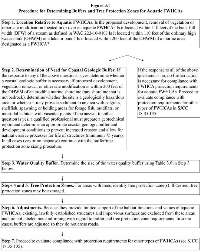
Site-Specific Procedure for Sizing Buffers and Tree Protection Zones.
Step 1. Location Relative to Aquatic FWHCAs. Is the proposed development, removal of vegetation or other site modification located in or over a designated aquatic FWHCA? Is it located within 110 feet of the bank full width (BFW) of a stream as defined in WAC 222-16-010? Is it located within 110 feet of the ordinary high water mark (OHWM) of a lake or pond? Is it located within 200 feet of the OHWM of a marine area designated as a FWHCA? If the answer to any of these questions is yes, continue to the next question. If the answer to all of these questions is no, no further action is necessary for compliance with requirements for aquatic FWHCAs; proceed to SJCC 18.35.135 to evaluate compliance with protection requirements for other types of FWHCAs.
Step 2. Determine if coastal geologic buffer is necessary. If proposed development, vegetation removal or other site modification is within 200 feet of the OHWM of an erodible marine shoreline (any shoreline that is not bedrock), determine if the site is a geologically hazardous area (see SJCC 18.35.055 through 18.35.070), or if it may provide sediment to an area with eelgrass, shellfish, spawning or holding areas for forage fish, mudflats, or intertidal habitats with vascular plants. If yes, a qualified professional must prepare a geotechnical report in accordance with SJCC 18.35.055 through 18.35.070, determine erosion causes and rates, and determine appropriate buffers and other measures to prevent increased erosion and allow for natural erosive processes for life of the structure (minimum 75 years). If collection and direct discharge of stormwater is recommended, the stormwater, including runoff from the roof, must first be treated to remove contaminants.
Step 3. Determine the size of the aquatic FWHCA water quality buffer using Table 18.35.130-1. The director may reduce the standard buffer widths in an urban growth area when impacts to critical areas are mitigated according to SJCC 18.35.040 and the buffer reduction is consistent with all other applicable requirements of this section; provided, that the buffer of an aquatic FWHCA shall not be reduced to less than 75 percent of the required buffer or 50 feet, whichever is greater.
|
Land Use Intensity1 |
||
|---|---|---|
|
Low |
Medium |
High |
|
50 feet |
75 feet |
100 feet |
1 See Table 18.35.100-2 for a list of land uses that are considered low, medium or high land use intensity.
2 Buffers shall be increased by 50 percent on slopes greater than 30 percent.
The water quality buffer extends landward horizontally from the bank full width of streams (as defined in WAC 222-16-010) and the OHWM of lakes, ponds, and marine shorelines.
Step 4. For areas with trees, including individual trees, identify tree protection zones. Trees and the wood, leaves, needles and insects that are associated with trees help support the aquatic food chain and aquatic FWHCAs. Use Table 18.35.130-2 to determine the landward extent of the area to be evaluated for tree protection zone requirements. If any trees are in these evaluation areas, they must be protected with a tree protection zone. Tree protection zones include the area within the drip line of each tree along with the area between the drip line and the bank full width of streams or the OHWM of lakes, ponds, or marine shorelines. For individual trees, the tree protection zone must be at least as wide as the drip line of the tree being protected. For example, for a type F stream with one tree with the trunk located 80 feet from the bank full width of the stream, with a drip line 30 feet in diameter, the dimensions of the tree protection zone would be 30 feet by 80 feet plus the area within the drip line on the uphill side of the tree. For a tree with the trunk located 20 feet from the shoreline, with a drip line 30 feet in diameter, the dimensions of the tree protection zone would be 30 feet by 20 feet plus the area within the drip line on the uphill side of the tree.
|
Type of Water Body1 |
Tree Protection Zone Evaluation Area (measured horizontally) |
|---|---|
|
Type F (Type 2 or 3) streams, lakes, ponds designated as FWHCAs, and marine waters (Type S) designated as FWHCAs |
110 feet from ordinary high water mark or bank full width2 |
|
Type Np (Type 4) streams |
50 feet from bank full width |
|
Type Ns (Type 5) streams |
30 feet from bank full width |
|
Type Ns (Type 5) streams flowing less than 6 months per year |
Stream banks must be vegetated |
1 Stream types under both the new and old classification systems shown (see WAC 222-16-030 and 222-16-031).
2 Within urban growth areas, this may be reduced to 50 feet if adverse impacts are identified and mitigated in accordance with SJCC 18.35.040.
Step 5. Averaging of Tree Protection Zones. Averaging of tree protection zones allows reduction of the zone in specified locations on the property proposed for development, vegetation removal or other site modification, in conjunction with increases of the zone in other areas, so that the total area of the zone is unchanged. The applicant may average the tree protection zone if all of the following criteria are met:
1. Averaging is necessary to accomplish the purposes of the proposal, and no reasonable alternative is available;
2. The total area contained within tree protection zones after averaging is no less than that contained within the zones prior to averaging;
3. Only areas with trees located within 200 feet of the OHWM or bank full width will be counted toward the required area of the tree protection zones; and
4. In no case shall the tree protection zones be reduced to less than the water quality buffer or 70 feet, whichever is greater.
Step 6. Adjustments. Buffers and tree protection zones do not cross some roads. Buffers and tree protection zones do not extend across public roads. For private roads, buffers and tree protection zones do not extend across the road when the road design, flow of runoff, quantity of traffic, and/or gap in tree canopy result in an area that does not support functions and values of the FWHCA to be protected, as determined by a qualified professional.
Step 7. Proceed to evaluate compliance with protection requirements for other types of FWHCAs in SJCC 18.35.135.
B. Structures, Uses and Activities Allowed and Prohibited in and over Aquatic FWHCAs and their Water Quality Buffers and Tree Protection Zones. Development activities, removal of vegetation and other site modifications are limited or prohibited within aquatic FWHCAs and their water quality buffers and tree protection zones. Allowable activities vary depending on whether the activity is within a tree protection zone or a water quality buffer, and are described separately below.
1. Tree protection zones are divided into two sections: Zone 1 consists of the first 35 feet adjacent to the water, beginning at the OHWM, or for streams, the bank full width. Zone 2 is the remainder of the tree protection zone.
To allow for a view or for fire hazard reduction, minor trimming and pruning of the foliage of trees within both Zone 1 and Zone 2 is permitted provided the health of the trees is maintained, trees are not topped, and all branches and foliage overhanging aquatic FWHCAs are retained. In no case shall more than 20 percent of the foliage of a tree be removed during one 12-month period.
Within Zone 1, no tree removal is allowed (though pruning is allowed in conformance with the above requirements). Within Zone 2, construction of one primary structure, and/or limited tree removal to allow for a filtered view from the primary structure, are allowed in conformance with all of the following:
a. The structure, impervious areas, and areas where soils will be graded, compacted or where the organic soil horizon will be removed, are located landward of the water quality buffer;
b. Appropriate BMPs are used to minimize erosion, sedimentation, and soil disturbance;
c. No more than 40 percent of the volume of trees over six inches dbh are removed in any 10-year period;
d. Stocking levels for trees greater than or equal to six inches dbh will not be reduced to less than:
i. Softwood stands such as Douglas fir (greater than 66 percent softwood volume): 80-square-foot basal area per acre including the area covered by any structures (approximately equivalent to 21 percent canopy cover);
ii. Mixed wood stands (34 to 66 percent softwood volume): 70-square-foot basal area per acre including the area covered by any structures; and
iii. Hardwood stands such as maple (less than 34 percent softwood volume): 50-square-foot basal area per acre including the area covered by any structures;
e. The remaining forest consists of trees that are multi-aged and are well distributed across the tree protection zone;
f. All vegetation overhanging aquatic FWHCAs is retained; and
g. For primary structures to be located in Zone 2, there is a low probability of increased windthrow of trees within tree protection zones as determined by a qualified professional.
2. Water Quality Buffers. Structures, uses and activities that are listed as “Yes” uses in Table 18.35.130-3 below are allowed within aquatic FWHCAs and required water quality buffers, subject to compliance with other sections of the San Juan County Code. State or federal requirements, administered by the Washington Department of Ecology, Washington Department of Fish and Wildlife, Washington Department of Natural Resources, and U.S. Army Corps of Engineers, may also apply to these areas.
|
Activity |
Aquatic FWHCA (the area within the water) |
Buffer |
|---|---|---|
|
a. Outdoor uses and activities that do not involve modifying the land or vegetation, and that will not adversely affect the functions and values of FWHCAs. |
YES |
YES |
|
b. The harvesting of wild plants and foods in conformance with applicable regulations and in a manner that is not injurious to the natural reproduction of native plants, provided the harvesting does not require tilling soil, planting, or changing existing topography, water conditions, or water sources, except when allowed as an agricultural activity under (e) below. |
YES |
YES |
|
c. Removal of invasive plants; planting of native plants; vegetation management activities intended to preserve and maintain specific habitats for rare species; and vegetation management activities implemented as part of a habitat management plan developed or approved by a local, state or federal agency. |
YES |
YES |
|
d. Agricultural activities conducted in accordance with a voluntary stewardship program developed pursuant to RCW 36.70A.705, with the exception of the construction of agricultural structures which are subject to the same provisions as other structures. |
YES |
YES |
|
e. With the exception of the construction of agricultural structures, agricultural activities, including seasonal and recurrent activities, existing or in development during the year prior to the effective date of the ordinance codified in this section, provided they do not result in additional adverse impacts to the functions and values of FWHCAs. This can include changing the type of farming, management practices, and crops within the existing geographic area already in use (such as in the rotational management of farmland) as long as the change does not result in additional adverse impacts to FWHCA functions and values. Agricultural structures are subject to the same provisions as other structures. (Note: See definition of “garden” in SJCC 18.20.070.) |
YES |
YES |
|
f. Aquacultural activities including seasonal and recurrent activities, existing or in development during the year prior to the effective date of the effective date of the ordinance codified in this section, provided they do not result in additional adverse impacts to the functions and values of aquatic FWHCAs. This can include changing the type of aquaculture, management practices, and products within the existing geographic area already in use, as long as the change does not result in additional adverse impacts to FWHCA functions and values. Aquacultural structures are subject to the same provisions as other structures. Aquacultural activities are also subject to the requirements of Chapter 18.50 SJCC. |
YES |
YES |
|
g. Temporary development activities defined in SJCC 18.20.200; provided, that reasonable efforts are made to avoid impacts to FWHCA functions and values and any adverse impacts are mitigated in accordance with SJCC 18.35.040. |
NO |
YES |
|
h. New and expanding aquacultural activities that are consistent with appropriate best management practices (BMPs) approved by the Department of Ecology. The BMPs must be described in a management plan. New and expanding aquacultural activities must not result in additional adverse impacts to FWHCA functions and values. New aquacultural structures are subject to the same provisions as other structures. Aquacultural activities are also subject to the requirements of Chapter 18.50 SJCC. |
YES |
YES |
|
i. Noncompensatory Enhancement. Restoration or enhancement activities not required as project mitigation, provided the activity is approved by the U.S. Fish and Wildlife Service, the Washington State Department of Ecology, Washington State Department of Fish and Wildlife, or other responsible local, state, federal, or tribal jurisdiction. |
YES |
YES |
|
j. Within the water quality buffers of aquatic FWHCAs, the establishment and expansion of orchards and gardens, cultivated and managed with appropriate BMPs, and without the use of synthetic chemicals; provided, that: i. They will occupy no more than 4,000 square feet of the buffer; ii. They are installed within the outer 25% of the buffer; iii. Other than fences, no structures or impervious surfaces are constructed or created, and fences will not impede the flow of water or prevent wildlife access to streams, ponds, lakes or shorelines designated as FWHCAs; iv. A buffer of at least 30 feet is retained; v. Trees within tree protection zones are protected in accordance with this section. |
NO |
YES |
|
k. The construction of trails, stairs, or raised walkways; provided, that the improvement: i. Is designed to direct sheet flow runoff into adjacent vegetation; ii. Does not exceed five feet in width; iii. Is constructed of nontoxic materials; iv. Does not include the placement of fill; v. Is consistent with the applicable requirements of subsection (E) of this section; and vi. For areas within shoreline jurisdiction, the improvement is consistent with the requirements of Chapter 18.50 SJCC and subsection (G) of this section. |
YES |
YES |
|
l. Temporary wildlife watching blinds. |
YES |
YES |
|
m. Drilling and digging of wells, provided they are located within the outer 25% of the water quality buffer, that there are no anticipated adverse impacts to adjoining FWHCAs, that measures are taken to avoid compaction of soils during drilling and development of the well, and that disturbed areas are immediately stabilized. |
NO |
YES |
|
n. To allow for a view or for fire hazard reduction, minor trimming and pruning of the foliage of trees and shrubs, provided the health of the trees and shrubs is maintained, trees are not topped, and all vegetation overhanging aquatic FWHCAs is retained. In no case shall more than 20% of the foliage of individual trees or shrubs be removed during one 12-month period. |
NO |
YES |
|
o. Components of stormwater management facilities in conformance with local and state stormwater management requirements and the tree protection zone requirements of this section; provided, that reasonable efforts are made to avoid impacts to aquatic FWHCA functions and values and any adverse impacts are mitigated in accordance with SJCC 18.35.040. |
NO |
YES |
|
p. Fences provided they do not impede the flow of water or prevent wildlife access to the shoreline. |
NO |
YES |
|
q. Stream crossings, and roads and trails in water quality buffers and tree protection zones, in conformance with subsection (E) of this section. |
YES |
YES |
|
r. Storage of chemicals. |
NO |
NO |
|
s. Components of on-site sewage disposal system in conformance with local and state requirements: |
|
|
|
i. Watertight septic tanks and pump chambers; |
NO |
YES |
|
ii. Sleeved and watertight sewer lines; and/or |
YES |
YES |
|
iii. Drainfields. These components are allowed provided reasonable efforts are made to avoid impacts to aquatic FWHCA functions and values, and: (A) BMPs are used to minimize erosion, sedimentation and soil disturbance; (B) For new systems, trees within tree protection zones are retained in accordance with subsection (B) of this section; (C) Any adverse impacts to critical areas are mitigated in accordance with SJCC 18.35.040; and (D) For replacement of existing, failing system where there is no other alternative that will meet state requirements (including locating the new system in the same place as the old system, trees within the tree protection zones are retained to the greatest extent possible). |
NO |
YES, outside of the water quality buffer |
|
t. Development, vegetation removal, or other modification allowed pursuant to an exemption, a reasonable use exception, and provisions for nonconforming uses, structures and activities outlined in SJCC 18.35.020 through 18.35.050. |
YES |
YES |
|
u. Structures, uses and activities allowed pursuant to an approved variance (see SJCC 18.80.100). |
YES |
YES |
|
v. Shoreline modifications in conformance with Chapter 18.50 SJCC and subsection (G) of this section. |
YES |
YES |
|
w. Other uses that will not adversely impact the functions and values of aquatic FWHCAs, considering the best available science. |
P/C 1 |
P/C 1 |
1 “P/C” means provisional or conditional use permit depending on the level of impacts (see SJCC 18.80.090).
C. Field Marking of Buffers and Tree Protection Zones. Prior to building permit approval, the location of the outer extent of buffers and tree protection zones adjacent to the area that will be developed shall be marked in the field, and the director may require field approval prior to the commencement of permitted activities. Markings for buffers and tree protection zones shall be maintained throughout the duration of construction activities.
D. For recorded plats, short plats, and binding site plans, the applicant shall show the boundary of required buffers and tree protection zones on the face of the plat or plan.
E. Stream Crossings, Roads, and Trails in Water Quality Buffers and Tree Protection Zones. The construction of new or expanded roads, driveways, trails and associated culverts and bridges across streams, buffers and tree protection zones is allowed in conformance with SJCC 18.60.080 through 18.60.100 and the following:
1. New roads and driveways may only be constructed across streams, or through buffers or tree protection zones, if there is no practicable alternative.
2. For Type F streams, bridges, culverts and crossings shall be designed according to the Washington Department of Fish and Wildlife “Design of Road Culverts for Fish Passage, 2003.” For streams that support fish that are designated for protection under the federal Endangered Species Act, the following may also apply as determined by the agencies with jurisdiction: the National Marine Fisheries Service “Guidelines for Salmonid Passage at Stream Crossings, 2000”; and “Washington State Fish Passage and Habitat Enhancement Restoration Programmatic,” National Marine Fisheries Service Tracking No. 2008-03598.
3. When practicable, new roads, driveways, trails and walkways shall be located on existing road grades, utility corridors or previously disturbed areas.
4. When required, permits and approvals must be obtained from appropriate state and federal agencies, including but not limited to: Washington Department of Fish and Wildlife; Washington State Department of Ecology; Washington State Department of Natural Resources; U.S. Army Corps of Engineers; U.S. Coast Guard; NOAA Fisheries Service; and U.S. Fish and Wildlife Service.
5. The road, culvert or bridge shall be located and designed to minimize adverse impacts, and shall not interfere with fish passage, the movement of water, large woody debris, gravel, or other stream processes. Roads must cross aquatic FWHCAs and buffers at, or as close as possible to, a 90-degree angle. Crossings shall not occur in salmonid spawning areas unless no other feasible crossing site exists. In streams with salmonid breeding habitat, bridges, bottomless culverts or other alternatives that will allow for fish passage are required, and bridge piers or abutments may not be placed within the stream or stream banks unless there is no feasible alternative. The length of conventional culverts shall be the minimum necessary.
6. The location and design of the road or driveway crossing must be evaluated by a qualified professional to ensure that ecological processes will not be adversely affected.
7. Construction must occur during work windows and time limits established by the state and federal agencies with jurisdiction.
8. All stream crossings shall be designed to accommodate 100-year projected flood flows.
9. When practicable, crossings shall serve multiple properties.
10. When expanding existing crossings that do not meet these standards, the crossing shall be upgraded as necessary to reduce stream impacts and meet the requirements of this subsection. For purposes of this section, an expansion is an increase in the footprint of the crossing structures or the associated roads and trails.
11. Roads and driveways must be crowned, insloped, outsloped or otherwise designed to direct runoff from the road surface into vegetated areas.
F. Within Shoreline Jurisdiction, Reduced Water Quality Buffers and Tree Protection Zones When Views of the Water Are Blocked by Existing Houses on Adjoining Waterfront Parcels. If existing houses on adjoining waterfront parcels are closer to the water than what is specified in this section, reduced buffer and tree protection zones shall be authorized if:
1. Adverse impacts to aquatic FWHCAs, if any, are identified by a qualified professional;
2. Adverse impacts are mitigated in conformance with SJCC 18.35.020 through 18.35.050; and
3. The authorized buffer and tree protection zones are the greater of:
a. The waterward side of a line drawn between the most waterward points of the houses on the adjoining parcels; and
b. The average of the distances from the OHWM to the most waterward points of the houses on the adjoining parcels.
G. Standards and Requirements for Shoreline Modifications. Shoreline modifications, including shoreline stabilization measures, are allowed within and over aquatic FWHCAs and their buffers subject to this section and Chapter 18.50 SJCC. These requirements remain in effect until they are replaced with an approved comprehensive update of the Shoreline Master Program. Unless specifically allowed by this section and Chapter 18.50 SJCC, construction of new shoreline modifications is prohibited.
1. General Standards.
a. Definitions. Definitions applicable to this subsection (G) are found in RCW 90.58.030 and WAC 173-26-020 and 173-27-030.
b. Mitigation Sequencing. Per WAC 173-26-201(2)(e), adverse impacts associated with new, expanded or replacement shoreline modifications must be mitigated consistent with the requirements of SJCC 18.35.020 through 18.35.050 and the following mitigation sequence:
i. Avoiding the impact altogether by not taking the action or part of the action.
ii. Minimizing impacts by limiting the degree or magnitude of the action and its implementation by using appropriate technology or by taking affirmative steps to avoid or reduce impacts.
iii. Rectifying the impact by using appropriate technology or by repairing, rehabilitating or restoring the affected environment.
iv. Reducing or eliminating the impact over time by preservation and maintenance operations.
v. Compensating for the impact by replacing, enhancing or providing substitute resources or environments.
vi. Monitoring the impact and compensation projects and taking appropriate corrective measures.
c. In accordance with WAC 173-26-221(2)(c)(iii)(C), if inventories of critical saltwater habitats have not been completed, over-water and nearshore developments in marine waters designated as FWHCAs may not be approved without an inventory of the site and adjacent shoreline parcels to assess the presence of these habitats and their functions. The methods and extent of the inventory shall be consistent with accepted research methodology, in consultation with Department of Ecology technical assistance materials.
d. Public docks and docks serving five or more single-family residences, piers, bulkheads, bridges, fill, floats, jetties, utility crossings, lifts, stairs, ramps, and other human-made structures shall not intrude into or over critical saltwater habitats unless all of the following conditions are satisfied:
i. The public’s need for such an action or structure is clearly demonstrated and the proposal is consistent with protection of the public trust as embodied in RCW 90.58.020. To show the project protects the public trust, the application shall include a narrative that:
(A) Demonstrates the proposal is consistent with the goals, policies and regulations of the County’s SMP and is appropriate for the location;
(B) Itemizes the project’s benefits for the public, such as providing physical or visual access to the shoreline; and
(C) Shows that the development will not have an adverse impact on the navigability of adjacent waters.
ii. Avoidance of impacts to critical saltwater habitats by an alternative alignment or location is not feasible or would result in an unreasonable and disproportionate cost to accomplish the same general purpose;
iii. The project, including any required mitigation, will result in no net loss of ecological functions associated with critical saltwater habitat; and
iv. The project is consistent with the state’s interest in resource protection and species recovery.
e. When feasible, public access and ecological restoration shall be incorporated into publicly financed projects.
2. Additional Standards for Docks.
a. Private, noncommercial docks and associated piers and floats for individual residential use, or for community use by the owners of no more than four adjacent or nearby residences, will be permitted over critical salt and fresh water habitats if the application complies with the applicable federal and state regulations and shows that:
i. Avoidance of impacts to critical salt and fresh water habitats by an alternative alignment or location is not feasible; and
ii. The project, including any required mitigation, will result in no net loss of ecological functions associated with critical saltwater habitat.
b. Application Requirements. In addition to applicable requirements of Chapter 18.50 SJCC, applications for approval of docks listed in this section shall include the following:
i. The applicable items listed in SJCC 18.80.020(C) (Project Permit Applications – Forms) along with photos of the site and a map showing the approximate location of critical areas and critical saltwater habitats within 200 feet of the project area (existing maps may be used).
ii. The applicable items listed in SJCC 18.80.110 (shoreline permits).
iii. Any related project documents such as applications to other agencies or environmental documents prepared pursuant to the State Environmental Policy Act.
iv. A narrative explaining how the proposal meets the requirements of this subsection (G), SJCC 18.35.020 through 18.35.050 and Chapter 18.50 SJCC.
v. Best available science documents supporting the proposal.
vi. A copy of proposed stormwater and erosion control plans for the project as required by Chapter 18.60 SJCC.
vii. A report, appropriate for the scale and scope of the project, prepared by a qualified biological professional, identifying any aquatic FWHCAs located within 50 feet of the proposed project, evaluating conformance of the proposal with the requirements of this subsection (G), and describing any potential adverse impacts to the ecological function of aquatic FWHCAs that may result from the proposal.
3. Additional Standards for Shoreline Stabilization Measures.
a. In order to avoid the individual and cumulative net loss of ecological functions attributable to shoreline stabilization, the following standards shall apply to shoreline stabilization measures:
i. New development on bedrock shorelines should be located and designed to avoid the need for future shoreline stabilization to the extent feasible.
ii. New development on all shorelines other than bedrock shall be set back sufficiently to ensure that shoreline stabilization is unlikely to be necessary during the life of the structure (minimum 75 years), as demonstrated by a geotechnical analysis.
iii. Using geotechnical analysis of the site and shoreline characteristics, subdivision of land must assure that the lots created will not require shoreline stabilization in order for development to occur.
iv. With the exception of areas located on bedrock, shoreline stabilization measures are not allowed to protect vegetated areas.
b. When structural shoreline stabilization measures are demonstrated to be necessary, the following are required:
i. The size of stabilization measures shall be limited to the minimum necessary. Measures designed to assure no net loss of shoreline ecological functions shall be used. Soft approaches shall be used unless they are demonstrated to be insufficient to protect primary structures, dwellings, and businesses.
ii. Publicly financed or subsidized shoreline stabilization control measures shall not restrict appropriate public access to the shoreline except where such access is determined to be infeasible because of incompatible uses, safety, security, or harm to ecological functions. Where feasible, ecological restoration and public access improvements shall be incorporated into the project.
iii. New shoreline stabilization measures, including replacement structures on feeder bluffs and other actions that affect beach sediment-producing areas, shall be mitigated and, if that is not possible, designed and constructed to minimize adverse impacts to sediment conveyance systems.
c. An existing shoreline stabilization structure may be replaced with a similar structure if a geotechnical report demonstrates the need to protect principal uses or structures from erosion caused by currents, tidal action, or waves.
i. The replacement structure should be designed, located, sized, and constructed to assure no net loss of ecological functions.
ii. Replacement walls or bulkheads shall not encroach waterward of the ordinary high water mark or existing structure unless the residence was occupied prior to January 1, 1992, and there are overriding safety or environmental concerns. In such cases, the replacement structure shall abut the existing shoreline stabilization structure.
iii. Where a net loss of ecological functions associated with critical saltwater habitats would occur by leaving the existing obsolete structure, it shall be removed as part of the replacement project.
iv. Soft shoreline stabilization measures that provide restoration of shoreline ecological functions may be permitted waterward of the ordinary high water mark.
v. For purposes of this subsection (G), “replacement” means the construction of a new structure to perform a shoreline stabilization function of an existing structure which can no longer adequately serve its purpose. Additions to or increases in size of existing shoreline stabilization measures shall be permitted as new structures.
d. Soft structural shoreline stabilization measures that restore shoreline ecological functions without creating additional uplands will be permitted waterward of the ordinary high water mark subject to the provisions of this section, Chapter 18.50 SJCC and applicable federal and state requirements.
e. New structural stabilization measures shall not be allowed except when necessity is demonstrated in the following manner:
i. To protect existing primary structures:
(A) New or enlarged structural shoreline stabilization measures for an existing primary structure, such as a residence, should not be allowed unless there is conclusive evidence, documented by a geotechnical analysis, that the structure is in danger and will suffer damage from shoreline erosion caused by tidal action, currents, or waves and where no alternatives, including relocation or reconstruction of existing structures, are found to be feasible and less expensive than the proposed stabilization measure.
(B) Normal sloughing, erosion of steep bluffs, or shoreline erosion itself, without a scientific or geotechnical analysis, is not demonstration of need.
(C) The geotechnical analysis should evaluate on-site drainage issues and address drainage problems away from the shoreline edge before considering structural shoreline stabilization.
(D) The shoreline stabilization structure, including any required mitigation, will not result in a net loss of shoreline ecological functions.
ii. To protect and support new non-water-dependent development including single-family residences, when all of the conditions below apply:
(A) The erosion is not being caused by upland conditions, such as drainage and the loss of vegetation.
(B) Nonstructural measures, such as placing the development further from the shoreline, planting vegetation, or installing on-site drainage improvements, are not feasible or not sufficient.
(C) No alternatives, including relocation or reconstruction of existing structures, are found to be feasible and less expensive than the proposed stabilization measure.
(D) The need to protect primary structures from damage due to erosion is demonstrated through a geotechnical report. The damage must be caused by natural processes, such as tidal action, currents, and waves.
(E) The shoreline stabilization structure, including any required mitigation, will not result in a net loss of shoreline ecological functions.
iii. To protect and support water-dependent development, when all of the conditions below apply:
(A) The erosion is not being caused by upland conditions, such as the loss of vegetation and drainage.
(B) Nonstructural measures, planting vegetation, or installing on-site drainage improvements is not feasible or not sufficient.
(C) No alternatives, including relocation or reconstruction of existing structures, are found to be feasible and less expensive than the proposed stabilization measure.
(D) The need to protect primary structures from damage due to erosion is demonstrated through a geotechnical report.
(E) The shoreline stabilization structure, including any required mitigation, will not result in a net loss of shoreline ecological functions.
iv. To protect projects for the restoration of ecological functions or hazardous substance remediation projects pursuant to Chapter 70.105D RCW, when all of the conditions below apply:
(A) Nonstructural measures, planting vegetation, or installing on-site drainage improvements is not feasible or not sufficient.
(B) The shoreline stabilization structure will not result in a net loss of shoreline ecological functions.
f. Application Requirements. In addition to applicable requirements of Chapter 18.50 SJCC, applications for approval of structural shoreline stabilization measures regulated by this section shall include the following:
i. The applicable items listed in SJCC 18.80.020(C) (Project Permit Applications – Forms) along with photos of the site and a map showing the approximate location of critical areas and critical saltwater habitats within 300 feet of the project area (existing maps may be used).
ii. Any related project documents such as applications to other agencies or environmental documents prepared pursuant to the State Environmental Policy Act.
iii. A narrative explaining how the proposal meets the requirements of this subsection (G) and Chapter 18.50 SJCC.
iv. Best available science documents supporting the proposal.
v. A copy of proposed stormwater and erosion control plans for the project as required by Chapter 18.60 SJCC.
vi. A report, appropriate for the scale and scope of the project, prepared by a qualified biological professional, identifying any aquatic FWHCAs located within 50 feet of the proposed project, evaluating conformance of the proposal with the requirements of this subsection (G), and describing any potential adverse impacts to the ecological function of aquatic FWHCAs that may result from the proposal. If the proposed structural stabilization measures may result in changes to longshore sediment transport, the report must include an evaluation of potential adverse impacts to aquatic FWHCAs located downdrift of the proposal.
vii. New, expanded and replacement structural stabilization measures require a geotechnical analysis and report, prepared by a qualified coastal geologic professional in accordance with SJCC 18.35.055 through 18.35.070, that includes the following:
(A) A description of the causes for the erosion;
(B) Past erosion rates over a period of at least 30 years;
(C) Projection of future rates of erosion over the next 30 years;
(D) Detailed topography from the proposed structure to the lower beach;
(E) Evaluation of the anticipated impact of sea level rise on the structural stabilization measure, ecological functions associated with critical saltwater habitat, and the development being protected, considering the most recent sea level rise predictions used by the San Juan County public works department in planning road improvements;
(F) In the case of an application for hard structural stabilization measures, the report shall contain a determination that in the absence of such measures, there is a significant possibility that the structure to be protected will be damaged by shoreline erosion within three years;
(G) If the report shows that waiting until the need for stabilization is immediate would foreclose the opportunity to use measures that avoid impacts to ecological functions, the report may be used to justify the construction of soft structural stabilization measures;
(H) Analysis of slope stability and mechanism for slope failure in the vicinity;
(I) Estimate of when the structure to be protected will be undermined (including allowance for bank recession equal to the largest documented landslide in the vicinity);
(J) Summary of factors causing threat to the structure;
(K) Evaluation of potential effectiveness of corrective measures for on-site drainage issues as an alternative to installing hard or soft structural shoreline stabilization measures;
(L) Detailed evaluation of the potential for relocating the structure as an alternative to hard or soft structural shoreline stabilization measures;
(M) Description of any potential adverse impacts that may result from the proposal, including anticipated changes to the size or quantity of the substrate and/or sediment in the vicinity or downdrift from the site; and
(N) An evaluation of the conformance of the proposal with the requirements of this subsection (G) and Chapter 18.50 SJCC.
viii. Mitigation and Monitoring Plans. Plans for mitigating any unavoidable adverse impacts to adjacent or nearby properties, or to the functions and values of critical saltwater habitats, must be consistent with the mitigation sequence above and the requirements of SJCC 18.35.020 through 18.35.050. (Ord. 1-2015 § 3; Ord. 2-2014 § 10; Ord. 29-2012 § 1; Ord. 12-2001 § 4; Ord. 2-1998 Exh. B § 3.6.9. Formerly 18.30.160(E))
18.35.135 Fish and wildlife habitat conservation areas – Additional protection recommendations and requirements for specific species and habitats.
This subsection outlines additional recommendations, and in some cases requirements, for protecting particular species and habitats. Maps showing the general location of some plants, animals and habitats are available from San Juan County. Though state regulations prohibit general dissemination of detailed habitat and species maps, County staff can provide available information on particular sites.
A. Animals. This subsection outlines additional protection recommendations and in some cases requirements for specific animals listed in SJCC 18.35.115. This includes animals that are currently listed under the Endangered Species Act, as well as animals designated by San Juan County as species of local importance. The requirements identified in this subsection supplement the more general requirements of this section and the San Juan County Code, including those requirements intended to protect the quantity and quality of ground and surface water, and to support the aquatic food chain.
To aid property owners in implementing effective protection measures, standardized habitat management plans based on the provisions of Table 18.35.135-1 will be attached to permits and approvals. Approval of development and project permits will be contingent on compliance with these plans.
|
Species |
Habitat Description |
Protection Methods (Recommended unless noted as a requirement) (For additional information see http://wdfw.wa.gov/hab/phslist.htm) |
|---|---|---|
|
Amphibians |
|
|
|
Sharp-tailed snake |
Relatively open, moist, woodlands, particularly near streams and secluded, south facing, rocky slopes. They spend most of the time under rocks and rotting woody material. Primary food source is slugs. Use communal egg laying sites in cracks between rocks, underground or in clumps of grass roots. |
In areas with sharp-tailed snakes: • Minimize soil-disturbing activities. • Retain rocks and down wood. • Avoid predation by domestic cats. |
|
Western toad |
Live near springs, streams, meadows and woodlands, especially those within approximately 1,640 feet of ponds or wetlands. Feed on insects. Preferred breeding sites are water bodies with shallow, sandy bottoms. After breeding they disperse into terrestrial habitats such as forests and grasslands, preferring damp conditions. Spend much time underground, often in small mammal burrows, beneath logs, and within rock crevices. Hibernate in burrows over the winter. |
In areas with western toads: • Establish wetland buffers based on a Category 1 wetland rating. Protect buffers in accordance with SJCC 18.35.085 through 18.35.105 (required). • Minimize soil-disturbing activities. • Prevent pollution of runoff. • Retain rocks and down wood. • Avoid the introduction of aquatic predators (e.g., fish) into ponds and lakes. |
|
Birds |
|
|
|
American dipper |
Shorelines of perennial streams and lakes and ephemeral streams that flow into them. |
• Prevent disturbance of active nesting areas during the spring. • Do not inhibit perennial flow in streams (required). • Maintain buffers along streams and lakes (required). |
|
American kestrel |
Open habitats with perching spots, including the edges of oak woodlands, open forests, and grasslands or agricultural areas with utility wires, fence posts or trees. Nest in tree cavities, cliffs, openings in manmade structures, and nesting boxes. |
• Protect snags and trees used for nesting (required). |
|
Black oystercatcher |
These birds nest on the ground above the rocky intertidal zone in areas without predatory mammals. |
• Maintain forage fish populations and protect kelp and eelgrass beds in conformance with the Unified Development Code. • Discourage human presence near active nesting areas during the spring. |
|
Chipping sparrow |
Savannas, orchards, low-density residential areas. |
• Prevent disturbance of active nesting areas during the spring. • Maintain mix of open land and wooded areas. |
|
Common nighthawk |
Rocky balds and flat areas with minimal vegetation |
• Prevent disturbance of active nesting areas during the spring. |
|
Fox sparrow |
Nesting occurs in dense shrub thickets with little or no forest canopy. The only suspected nesting is on small outer islands. |
• Prevent disturbance of active nesting areas during the spring. |
|
Great blue heron |
Feeding occurs in large ponds and wetlands, small ponds and wetlands not surrounded by forest, and marine waters. Nesting occurs in tall dense stands of conifers in areas mostly isolated from humans. |
• Within 1/4 mile of nesting colonies, avoid construction and activities that may disturb nesting birds February through September. • Protect wetlands and nearshore feeding areas in conformance with the Unified Development Code. • Maintain a 200-foot buffer around nests in colonies (required). |
|
Golden-crowned sparrow |
Nesting occurs in dense shrub thickets with little or no forest canopy. The only suspected nesting is on small outer islands. |
• Prevent disturbance of active nesting areas during the spring. |
|
Golden eagle |
Nesting usually occurs on cliffs, but may also occur in trees, on the ground, or on human-made structures. |
• Within 1,000 feet of nests, avoid construction and activities that may disturb nesting birds February 15th through July 15th. • Protect trees used for perching and nesting (required). • Maintain food sources and habitat for animals that are food sources (e.g., rodents, small mammals, birds). • Minimize disturbance of nesting areas during the spring. • See protection measures for peregrine falcon. • Avoid use of rodenticides in hunting areas. • Avoid construction of wind turbines near nesting and hunting areas. • Avoid construction of multiple-phase transformers in hunting and nesting areas. |
|
Horned lark |
Prairie/savanna and other flat areas with minimal vegetation. |
• Prevent disturbance of active nesting areas during the spring. |
|
Lazuli bunting |
Edges of oak woodlands, shrubby areas in forested zones, agricultural hedgerows, and shrubby habitat in residential gardens. |
• Protect shrubs and small trees used for nesting. • Protect food sources including seeds, berries and invertebrates. |
|
Long-eared owl |
Woodlands. No recent nesting records. |
• Prevent disturbance of active nesting areas during the spring. |
|
Marbled murrelet |
Nest in dense, mossy, wet, old growth conifer forests at least 7 acres in size and within 50 miles of marine waters. Nesting sites very difficult to identify. Nesting trees are at least 32 inches diameter and the nest itself is typically located in a depression in the moss and lichen. Murrelets feed year round on small, schooling fish and other small sea creatures found in calm, shallow (less than 100 feet), nearshore waters in the San Juans. Concentrations of birds are found on Lopez Island and the area between Orcas and Blakely Islands. They are not currently known to nest in the San Juans, but that could change as second growth forests mature. |
• Maintain forage fish populations and protect kelp and eelgrass beds in conformance with the Unified Development Code. • Protect old growth coniferous forests more than 7 acres in size that have trees more than 32 dbh that are used by nesting birds (see Chapter 222-16 WAC for guidance on determining the presence of nesting birds) (required). • If areas used for nesting are identified, County staff will work with the landowner and the Department of Fish and Wildlife to develop a site specific protection plan (required). |
|
Merlin |
Edges of conifer woodlands. |
• Prevent disturbance of active nesting areas during the spring. |
|
Northern goshawk |
Mature forest on main islands. |
• Prevent disturbance of active nesting areas during the spring. |
|
Northern harrier |
Infrequently mowed pastures, prairie, and herbaceous wetlands without trees. |
• Prevent disturbance of active nesting areas during the spring. • In areas used for nesting or feeding, establish wetland buffers based on a Category I wetland rating. Protect buffers in accordance with SJCC 18.35.085 through 18.35.105 (required). |
|
Northern pygmy owl |
Mature conifer forest on main islands. |
• Prevent disturbance of active nesting areas during the spring. |
|
Peregrine falcon |
Year-round residents in San Juan County (approximately 21 nesting pairs). Nest on cliffs and ledges. Feed on birds, especially shorebirds and waterfowl. |
• Within 1/4 mile of nests, avoid construction and activities that may disturb nesting birds March 1st through June 30th. • If possible, locate structures at least 1,500 feet back from cliffs with nests. • Prevent pesticide and chemical contamination of prey. Chemicals of particular concern include: lead, mercury, organochlorides, organophosphates, carbofuran, and famphur. • Near nesting and feeding areas, do not use lead shot, avoid use of insecticide, and avoid use of pesticides that will be ingested by birds that are food sources (e.g., pigeons). • Follow County stormwater and buffer requirements. • Avoid construction of power lines near nests or feeding areas. • Maintain trees along shorelines in conformance with this section. |
|
Pigeon guillemot |
This seabird nests in colonies in burrows on sandy and rocky cliffs. |
• Prevent disturbance of active nesting areas during the spring. |
|
Short-eared owl |
Infrequently mowed pastures, prairie, and herbaceous wetlands without trees. |
• Prevent disturbance of active nesting areas during the spring. • In areas with nesting or feeding short-eared owls, establish wetland buffers based on Category I wetland rating. Protect buffers in accordance with SJCC 18.35.085 through 18.35.105 (required). |
|
Sooty grouse |
Extensive conifer forest on main islands. |
• Prevent disturbance of active nesting areas during the spring. • Minimize fragmentation of forest by roads, driveways, and tree removal. |
|
Vesper sparrow |
Savanna, prairie, and fields with scattered shrubs. |
• Prevent disturbance of active nesting areas during the spring. |
|
Western bluebird |
Oak woodland and fields with nest boxes or many standing dead trees. |
• Prevent disturbance of active nesting areas during the spring. • Avoid pesticide use in or near active nesting areas. • Avoid removal of dead standing trees in or near active nesting areas. |
|
Western meadowlark |
Savanna, prairie, and fields with scattered shrubs. |
• Prevent disturbance of active nesting areas during the spring. • Avoid pesticide use in or near active nesting areas. |
|
Western screech owl |
Open woodlands, especially along streams. Nests in holes in cliffs and tree cavities, particularly cottonwood and big leaf maple. |
• Protect snags and trees used for nesting (required). |
|
Wilson’s snipe |
Herbaceous wetlands and wet fields with scattered shrubs |
• Prevent disturbance of active nesting areas during the spring. • Avoid pesticide use in or near active nesting areas. • In areas with nesting or feeding Wilson’s snipe, establish wetland buffers based on a Category I wetland rating. Protect buffers in accordance with SJCC 18.35.085 through 18.35.105 (required). |
|
Insects |
|
|
|
Great arctic butterfly |
Only recorded U.S. population located on Orcas Island. Dependent on forest openings and rocky balds. |
In areas with great arctic butterflies: • Avoid the use of insecticides and herbicides. • Protect rocky balds. |
|
Island marble butterfly |
Only remaining populations on San Juan (American Camp) and Lopez Islands. Dependent on Puget Sound peppergrass and other native mustards and nonnative mustards. |
In areas with island marble butterflies: • Avoid the use of insecticides and herbicides. • Limit grazing and agricultural land disturbance. • During land development, protect areas with food sources including Puget Sound peppergrass and other native and nonnative mustards. |
|
Sand verbena moth |
Only recorded U.S. populations on San Juan Island and in Clallam County. Dependent on native sandy coastal habitat and sand verbena (Abronia) for larval food plant. |
In areas with sand verbena moths: • Avoid the use of insecticides and herbicides. • Limit grazing and agricultural land disturbance. • During land development, protect areas with food sources including sand verbena (Abronia). |
|
Taylor’s checkerspot butterfly |
Extremely rare and declining throughout range. Associated with maritime prairies and shorelines along the Strait of Juan de Fuca, the post-glacial gravelly outwash and mounded prairies of the Puget Trough, and open island prairies with a dominance of original vegetation. Host plants include the native seaside plantain (Plantago maritima macrocarpa) and the nonnative English plantain (P. major lanceolata). Concentrations have been found in San Juan County on Long Island, and possibly Lopez Island. Current status unknown. |
In areas with Taylor’s checkerspot butterflies: • Avoid the use of insecticides and herbicides. • Limit grazing and agricultural land disturbance. • During land development, protect areas with plantain. |
|
Valley silverspot butterfly |
Dependent on Western blue violet (Viola adunca). Declining populations in San Juan Islands. Extinct in many locations. |
In areas with valley silverspot butterflies: • Avoid the use of insecticides and herbicides. • Limit grazing and agricultural land disturbance. • During land development, protect areas with western blue violet. |
|
Mammals |
|
|
|
Areas with roosting concentrations of all bat species |
Sites used for roosting include caves, mines, snags, large trees, buildings and barns. |
In areas with roosting concentrations of bats: • Avoid pesticide use. • Avoid removal of large dead trees (e.g., those over 12 inches dbh). |
|
Townsend’s big-eared bat |
Found where there are suitable roosting sites and fresh water. Sites used for roosting include caves, mines, snags, large trees, buildings and barns. Roosting during the winter is generally in caves, but may also occur in the cavities of large trees, and in buildings. Primary food source is moths, but they will consume other arthropods. |
In areas with roosting or feeding Townsend’s big-eared bats: • Avoid pesticide use. • Avoid removal of large dead trees. |
|
Flying squirrel |
Mature forests and woodlands with many dead standing trees. |
• Avoid removal of large dead trees in or near known areas. |
|
Other animal species listed under the Endangered Species Act or found to have a primary association with habitats in San Juan County after the effective date of the ordinance codified in this section |
|
Until this code is amended to include new species, appropriate protection recommendations will be developed in consultation with the Washington Department of Fish and Wildlife, U.S. Fish and Wildlife Service and National Marine Fisheries Service. |
B. Plants. For designated plants, informational materials will be provided with development and project permits, including photos of the plants, actions that can be taken to preserve them, and descriptions of how to reestablish plants that are displaced or destroyed during development, vegetation removal or other site modification activities. In addition, for designated plants that are located in a wetland, wetland water quality buffers shall be determined from Table 18.35.135-2. Habitat buffer widths shall be determined from Table 18.35.100-3 using the Category I wetland buffer width for the proposed type of land use intensity. These buffers must be protected in accordance with SJCC 18.35.085 through 18.35.105. Buffers are measured horizontally from the edge of the wetland. The director may reduce the standard buffer widths in an urban growth area when impacts to critical areas are mitigated according to SJCC 18.35.040 and the buffer reduction is consistent with all other applicable requirements of this section; provided, that the buffer of a Category I or II wetland shall not be reduced to less than 75 percent of the required buffer or 50 feet, whichever is greater.
|
Land Use Intensity1 |
||
|---|---|---|
|
Low |
Medium |
High |
|
50 feet |
75 feet |
100 feet |
1 See Table 18.35.100-2 for a list of land uses that are considered low, medium, or high land use intensity.
2 Buffers shall be increased by 50 percent on slopes greater than 30 percent.
C. Habitats of Local Importance. This subsection outlines additional protection requirements and recommendations for habitats of local importance. The requirements identified in this subsection supplement the more general requirements of this section and the San Juan County Code, including those requirements intended to protect the quantity and quality of ground and surface water, and to support the aquatic food chain.
To aid property owners in implementing effective protection measures, standardized habitat management plans based on the provisions of Table 18.35.135-3 will be attached to permits and approvals. Approval of development and project permits will be contingent on compliance with these plans.
|
Species or Habitat |
Habitat Description |
Protection Measures |
|---|---|---|
|
Bluff Backed Beaches |
Includes erosional depositional beaches at the base sediment bluffs, sediment-covered rock beaches, and seeps/small streams that enter beaches via a bluff rather than via a pronounced stream valley. Bluff backed beaches do not form lagoons (though they may be a sediment source to barrier beaches that do form lagoons). |
Minimize and encourage removal of hard shoreline stabilization measures. Compliance with the San Juan County Code. |
|
Garry Oak (Quercus garryana) Woodlands and Savannas |
Garry oak is a type of Oregon white oak found in warmer, drier areas within the Puget Sound and southern British Columbia. They are associated with what is becoming an increasingly rare ecosystem that supports a variety of rare wildflowers, butterflies (such as the duskywing (Erynnis propertius)) and other plants and animals. Garry oak ecosystems are highly varied and are found in areas with rock outcrops, coastal bluffs, maritime meadows, and treeless grasslands as well as seasonal wetlands, and are sometimes found in mixed stands with other trees including arbutus and Douglas fir. Acorns from the oaks provide a key food for many birds, and other wildlife. Areas in the County that contain Garry oak include English Camp, Cady Mountain, San Juan Valley, the west side of San Juan Island, Point Disney, Turtleback Mountain, West Sound. |
In conjunction with new development and vegetation removal, minimize disturbance of areas with Garry oak and associated native grasslands and wildflowers. Removal of Douglas fir and other conifers is encouraged and authorized in tree protection zones to allow adequate sunlight for the oak, grasses and wildflowers. If disturbance cannot be avoided, mitigate by replanting suitable areas with Garry oak, native grasses and wildflowers. |
|
Herbaceous Balds and Bluffs |
These are native plant areas located on shallow soils over bedrock, often on steep, exposed slopes with few trees. They support grasses, herbaceous plants, dwarf shrubs, brittle prickly pear cactus, mosses and lichens that are adapted for survival on shallow soils amid seasonally dry conditions. Trees that may be present include Douglas fir, Pacific madrone, and Garry oak. In San Juan County, this habitat supports many plant species that are rare or that grow in few other land cover types. They are the preferred habitat of the Taylor’s checkerspot butterfly, which is a listed species. Information on the plants associated with herbaceous balds and bluffs can be found at http://www1.dnr.wa.gov/nhp/refdesk/ communities/pdf/balds_veg.pdf. |
In conjunction with new development and vegetation removal, minimize disturbance of herbaceous balds and bluffs. |
|
Pocket Beaches |
Beaches that are contained between two bedrock headlands that essentially function as a closed system in terms of littoral sediment transport. Pocket beaches do not typically occur within a drift cell and there is little or no exchange of sediment between a pocket beach and adjacent shores. They can be found waterward of a rocky bank or cliff, or they may form barriers, sometimes partially or completely isolating a back-barrier lagoon or wetland. Pocket beaches are typically swash aligned, or oriented perpendicular to the direction of predominant wave approach. They are relatively short in length, as compared to the length of a barrier beach. In plan view, their shape is crescent shaped and they often have well-sorted sediment. |
Minimize and encourage removal of hard shoreline stabilization measures. Compliance with the San Juan County Code. |
|
West Side Prairie |
These are relatively undisturbed, uncultivated meadows and fallow fields that are mostly treeless, and ideally have a significant presence of native forbs (herbaceous flowering plants such as Camas) and grasses (e.g., Danthonia californica and Festuca rubra). West side prairies in San Juan County include parts of Mt. Constitution and Turtleback Mountain on Orcas Island, the west side of San Juan Island, Iceberg Point on Lopez Island, and Yellow Island. |
In conjunction with new development and vegetation removal, minimize disturbance of native grasslands and Camas prairies. If disturbance cannot be avoided, mitigate by replanting suitable areas with native grasses and wildflowers. |
(Ord. 1-2015 § 3; Ord. 2-2014 § 10; Ord. 29-2012 § 1; Ord. 12-2001 § 4; Ord. 2-1998 Exh. B § 3.6.9. Formerly 18.30.160(F))
18.35.140 Fish and wildlife habitat conservation areas – Nomination of species or habitats of local importance.
San Juan County has the option of protecting species and habitats of local importance. If not included in the adoption of the ordinance codified in this section, these species or habitats may be added by nominating the species or habitat and amending the ordinance through the following process:
A. A petition to nominate a habitat or a species to this category shall contain the following:
1. Documentation demonstrating that local populations of native species are sensitive to habitat manipulation, declining, or are in danger of extirpation based on existing trends;
2. An explanation of whether specific habitat features are being nominated for protection (for example, nest sites, breeding areas, or nurseries), or whether a habitat or ecosystem is being nominated in its entirety;
3. A map showing known locations of nominated species or habitats;
4. Proposed management and protection strategies for the species or habitats, supported by the best available science.
B. The director shall determine whether the nomination proposal is complete, and if complete, shall request that state and federal agencies and local conservation organizations review the proposal and provide comments and recommendations. These comments, the application, the recommendation of the director, and a draft code amendment incorporating the species and/or habitat shall be forwarded to the planning commission for a public hearing.
C. Following the recommendation of the planning commission, the County council shall hold a public hearing and make a decision on the request and associated code amendment, and if approved, shall add the species and/or habitat to SJCC 18.35.115.
D. Removal of Species or Habitats of Local Importance. Species and habitats may be removed by amending SJCC 18.35.115 in accordance with applicable requirements, including a public hearing before the planning commission and County council. (Ord. 1-2015 § 3; Ord. 2-2014 § 10; Ord. 29-2012 § 1; Ord. 12-2001 § 4; Ord. 2-1998 Exh. B § 3.6.9. Formerly 18.30.160(G))
18.35.145 Open space conservation overlay district.
A. Purpose. This section is adopted to implement the policies of the open space conservation overlay district of the Comprehensive Plan.
Citizens may want to give consideration to voluntary provisions for protection of their property.
B. San Juan Valley Agricultural Heritage Open Space Conservation Overlay District. An overlay district is established on agricultural resource lands within the San Juan Valley and Upper San Juan Valley landscape units on San Juan Island, as identified in Parts III and IV (Open Space Atlas and Map Folio) of the San Juan County Open Space and Conservation Plan (SJCC 18.30.190(F)). The area within this district is shown on the official maps.
1. Heritage Plan Overlay District Conservation Incentive Bonus. A conservation incentive bonus has been developed and adopted for land division in the overlay district for which some parcels will be eligible. The regulations governing this conservation incentive bonus are in SJCC 18.70.060(B)(10).
2. Effective Date. The San Juan Valley heritage plan overlay district conservation incentive bonus regulations became effective on June 6, 2002, upon the action of the Western Washington Growth Management Hearings Board to rescind its order of invalidity dated July 21, 1999, regarding the allowable density of some properties in the overlay district. (Ord. 25-2012 § 15; Ord. 26-2002 § 3; Ord. 11-2000 § 4; Ord. 2-1998 Exh. B § 3.6.10. Formerly 18.30.170)
18.35.150 Airport overlay district.
A. Purpose. To implement the policies of the Comprehensive Plan for airport overlay districts and the directives of RCW 36.70.547 and 36.70A.510. The airport overlay district is intended to protect the public health, safety and welfare, to recognize and protect those areas devoted to public-use aviation and associated activities from airspace obstructions or hazards, and to promote compatibility between airport uses and land uses and activities in the airport vicinity and environs.
B. Applicability.
1. The airport overlay district shall include the areas that are within aircraft accident safety zones, and FAA airspace zones if applicable, as depicted on the official maps, and any additional administrative area that is included in a district.
2. All project and development permits, subdivisions, binding site plans, and planned unit developments within the designated limits of an airport overlay district as shown on the official maps shall be subject to the regulations of this section and to the applicable performance standards in SJCC 18.40.030 et seq.
3. If there is any conflict between regulations of an airport overlay district and regulations of the underlying land use designation, the more restrictive regulations shall apply.
C. Aircraft Accident Safety Zones. These zones include the lands within the runway protection zone (zone 1), inner safety zone (zone 2), inner turning zone (zone 3), outer safety zone (zone 4), sideline safety zone/airport development zone (zone 5), and traffic pattern zone (zone 6) which are defined in Chapter 18.20 SJCC.
D. Allowable Uses. The performance standards of SJCC 18.40.030 et seq. for airports and airport overlay districts further limit and regulate the allowable and prohibited uses that are listed in Chapter 16.55 SJCC, the Eastsound Subarea Plan, and in Tables 18.30.030 and 18.30.040 for the underlying land use districts. Airport district ordinances may supplement these provisions for allowable uses. (Ord. 25-2012 § 16; Ord. 5-2002 § 3; Ord. 14-2000 § 7(DDD); Ord. 2-1998 Exh. B § 3.6.11. Formerly 18.30.180)
18.35.155 San Juan County fairgrounds overlay district.
A. Purpose. The purpose of this section is to implement the policies of the Comprehensive Plan for the San Juan Island fairgrounds overlay district. The fairgrounds overlay district is to allow land uses and developments at the fairgrounds property on San Juan Island in a manner that may not be otherwise allowed by the underlying land use district so that the San Juan County Fair may continue to serve the County-wide community over the long term, in its present capacities and in the accommodation of future uses consistent with its continued management for public-service purposes.
B. Applicability. These regulations apply to all areas within the fairgrounds overlay district as depicted on the official maps.
C. Allowable Uses. Allowable uses of the fairgrounds include the annual County Fair activities and events, and non-Fair uses including the following: recreational activities; use of fairgrounds facilities for meetings, workshops and classes; horse shows and horse events; garden shows and farmers’ markets including administrative space for the farmers’ markets; agricultural and horticultural facilities; trade exhibitions and conventions; dances, concerts, and children’s and youth programs; tent and RV camping during the fair and during other events at the fairgrounds, and as otherwise allowed by this subsection; and other unnamed uses which are similar, as determined by the fair and events manager, subject to the provisions of this subsection.
D. General Regulations.
1. Parking.
a. At least 400 parking spaces shall be provided on-site and/or off-site during the county fair. Off-site spaces shall be provided by binding agreement(s) with the owners of the off-site location(s).
b. Parking for all other fairgrounds uses shall be provided on-site.
2. Camping.
a. RV and tent camping for exhibitors, commercial vendors, workers and entertainers shall be allowed during the fair and during contracted dates of other major events, but in no case shall exceed a duration of eight days.
b. RV and tent camping spaces shall be allowed to be used at the fairgrounds to accommodate visitors to events on San Juan Island not occurring at the fairgrounds and not exceeding a duration of 10 days. Any such camping uses shall be subject to written agreements with the sponsor of the event being accommodated with fairgrounds camping sites.
c. Tent camping spaces may be rented at any time for a period not to exceed 10 days; provided, that tent camping spaces shall be used only by persons associated with a group camping arrangement with the fairgrounds manager.
d. Eight RV hookups may be made available at any time for a period not to exceed 10 days, whether or not the RV campers are attending events on San Juan Island.
e. No new RV hookups shall be permitted but existing hookups may be relocated within the fairgrounds.
3. Development Standards to Limit Off-Site Impacts.
a. Outdoor events at the fairgrounds shall be limited to the hours of 7:30 a.m. to midnight.
b. New structures and camping sites shall be set back at least 20 feet from Argyle Avenue, Dougherty Lane, and Mayer Way. (Ord. 11-2010 § 5. Formerly 18.30.185)