


Chapter 17.335
SUPPLEMENTARY DEVELOPMENT STANDARDS
Sections:
17.335.015 Exceeding height limits.
17.335.020 Height and location of fences and walls.
17.335.070 Drive-ins/drive-throughs.
17.335.080 Indoor marijuana-related businesses.
17.335.090 Pedestrian and bicycle access.
17.335.100 Transit facilities.
17.335.110 Zero lot line development.
17.335.120 Multi-unit dwelling standards.
17.335.130 Setbacks – Intrusions permitted.
17.335.140 Affordable housing incentives.
17.335.150 Solar use and placement.
17.335.010 Purpose.
In addition to other development standards in this land use code, this chapter provides specific development standards for certain development and uses. In the event of a conflict between the general development standards and the supplementary development standards, the provisions of the supplementary development standards control. [Ord. 541 § 6 (Exh. 1), 2021; Ord. 503 § 1 (Exh. B), 2018; Ord. 473 § 3 (Exh. A), 2016. Formerly 17.362.010].
17.335.015 Exceeding height limits.
The features listed below shall be exempt from the established height limits in the zoning districts provided the limitations indicated for each are observed.
(1) Mechanical equipment and appurtenances necessary to the operation or maintenance of the building or structure, including chimneys, ventilators, plumbing vent stack, cooling towers, water tanks, panel, or devices for the collection of solar or wind energy, and the window-washing equipment, together with required visual screening for any such equipment and appurtenances.
(2) The minimum additional height required for elevators, stairs, mechanical penthouses, fire towers, skylights, flag poles, aerials, and similar objects but not including storage space or other equipment unless listed in subsection (1) of this section.
(3) Ornamental and symbolic features not exceeding 200 square feet in gross floor area including towers, spires, cupolas, belfries, and domes, where such features are not used for human occupancy. [Ord. 541 § 6 (Exh. 1), 2021].
17.335.020 Height and location of fences and walls.
(1) Residential fences and walls not greater than eight feet in height shall be permitted on or within all property lines which are not within any vision clearance area.
(2) Fences and walls that conform with the standards required by the specific zones and this section may be constructed in required front yard, side yard and rear yard setbacks.
(3) Commercial fences or walls located in the following areas shall only be allowed subject to approval of a Type II review (Chapter 17.130 CBDC):
(a) Bayshore Drive between Elrod Avenue and Highland Avenue.
(b) Bayshore Drive north of Fir Avenue.
(c) South Empire Boulevard south of Newmark Avenue.
(d) 6th Avenue south of “F” Street.
(e) All area located in the downtown Coos Bay and Empire urban renewal areas in commercial land use districts.
(f) Chain link fences are prohibited in the areas noted in subsections (3)(a) through (e) of this section. [Ord. 541 § 6 (Exh. 1), 2021; Ord. 532 § 2 (Att. B), 2020; Ord. 524 § 7 (Exh. A), 2020; Ord. 503 § 1 (Exh. B), 2018; Ord. 473 § 3 (Exh. A), 2016. Formerly 17.362.020].
17.335.030 Solid waste.
If refuse containers are used by more than one unit for temporary storage of solid wastes, the container(s) shall be screened from view from off site by a sight-obscuring fence and/or evergreen landscaping and the area kept clean of all litter. [Ord. 503 § 1 (Exh. B), 2018; Ord. 473 § 3 (Exh. A), 2016. Formerly 17.362.030].
17.335.040 Lighting.
(1) Street lighting shall be a required component of all residential, commercial and industrial developments within the city of Coos Bay.
(2) Lighting, including permitted illuminated signs, shall be designed and arranged so as to not:
(a) Reflect or cast glare into any residential zone;
(b) Rotate, glitter, or flash; or
(c) Conflict with the readability of traffic signs and control signals.
(3) General Light Location. Lighting shall only be installed adjacent to structures, walkways, driveways, or activity areas (decks, patios, spas and pools, and similar use areas) and focal landscape areas close to the residence or activity area.
(4) Mounted Light Location.
(a) Building-mounted lights shall be installed below the eave line.
(b) Exterior light fixtures may be mounted on any exterior wall or structure at a minimum of eight feet above the adjacent finished floor level. However, a light fixture adjacent to a second story balcony, deck, or exterior doors may be mounted on the wall at a maximum height of eight feet above the finished floor level.
(c) Lighting features on any site shall not exceed 15 feet and 25 feet in height for freestanding outdoor light features on industrial property.
(5) Fixtures. Exterior lighting shall be hooded and arranged to reflect away from adjoining properties and streets.
(6) Level of Illumination. Exterior lighting shall represent the minimum level of illumination necessary to meet the aesthetic and security needs of the property. Light sources, intensity of light, and color of light shall be designed and located to achieve security or decorative lighting goals without causing an adverse impact on neighboring properties. Light sources shall be designed and located to minimize spillover of light or glare onto neighboring properties.
(7) Lighting Intensity. The lighting intensity within parking lots and adjacent areas shall be at least 1.0 foot-candle at all points, but shall not exceed an average of 3.0 foot-candles over the entire parking lot.
(8) Lighting Plan. A lighting plan is required for all applicable development demonstrating compliance with these lighting standards. Lighting plans shall be a required component of complete preliminary subdivision and partition applications. All lighting plans shall be approved by the director. [Ord. 541 § 6 (Exh. 1), 2021; Ord. 532 § 2 (Att. B), 2020; Ord. 503 § 1 (Exh. B), 2018; Ord. 473 § 3 (Exh. A), 2016. Formerly 17.362.040].
17.335.050 Noise.
All development shall comply with the noise standards established in the city. [Ord. 503 § 1 (Exh. B), 2018; Ord. 473 § 3 (Exh. A), 2016. Formerly 17.362.050].
17.335.060 Landscaping.
The following standards apply to landscaping and screening on private property required pursuant to this title. The city’s public works department shall review and authorize landscaping and screening within public rights-of-way.
(1) Applicability.
(a) At a minimum, 15 percent of each new commercial or industrial zoned lot or development must be landscaped to the standards within this chapter.
(b) At a minimum, 15 percent of new multi-unit dwelling developments must be landscaped to the standards within this chapter.
(2) General.
(a) Applicants are encouraged to provide flexible landscaping design that takes advantage of natural features and addresses the use and function of the proposed development. Landscaping choices should consider the aesthetic qualities of the existing site and provide attractive variety in tree and shrub species, texture, color, height and density.
(b) Existing vegetation may fulfill landscaping and screening requirements of this chapter if the existing landscaping provides at least an equivalent level of screening as the standard required for the development in question.
(c) As a condition of approval for a conditional use or PUD, the city may require an applicant to provide landscaping and screening that differs from the standards in this section where necessary to comply with the other applicable approval standards for the use or development.
(d) Landscaped areas required for stormwater management purposes may be used to satisfy the landscaping area requirements of this chapter.
(3) Landscape Standards.
(a) Required landscaping and screening shall be located on the perimeter of a lot or parcel. Required landscaping and screening shall not be located on a public right-of-way or private street easement, unless authorized by the city’s public works department.
(b) Multi-unit dwelling developments shall provide a minimum five-foot-wide landscape screen along all property lines that abut a low density residential zoning district, per the standards of subsections (3)(b)(i) through (iii) of this section.
(i) High shrubs that form a continuous screen, at least six feet high, within five years of planting.
(ii) One canopy tree per 30 linear feet as measured along interior lot lines.
(iii) Living plant materials covering a minimum of 70 percent of the required landscape area within five years of planting.
(iv) A masonry wall at least six feet high shall be permitted as a substitute for the shrubs but the trees and other plant materials are still required.
(c) Parking and loading areas shall be landscaped as follows:
(i) A minimum five-foot-wide landscaped strip shall be provided where vehicle parking or loading adjoins a public road right-of-way.
(ii) Parking areas throughout the development that contain at least seven spaces are required to provide perimeter parking area landscaping and parking area landscaping along street and driveway entrances. A landscape island shall contain at least 25 square feet, shall be at least four feet wide, and shall prevent vehicles from overhanging into this required area by using a wheel stop or curb. If a curb is used, the landscape islands shall be at least six feet wide.
(d) The applicant shall install required landscaping and screening consistent with the approved site plan or development, or an approved modification thereto, before the city issues an occupancy permit or final inspection for the development in question; the city may defer installation of plant materials for up to six months after the city issues an occupancy permit or final inspection for the development in question if doing so increases the likely survival of plants.
(4) Plant Materials.
(a) Landscape materials should be selected and sited to produce a hardy and drought-resistant landscape area. Selection should include consideration of soil type and depth, the amount of maintenance required, spacing, exposure to sun and wind, the slope and contours of the site, compatibility with existing native vegetation preserved on the site, water conservation where needed, and the impact of landscaping on visibility of the site for purposes of public safety and surveillance. Landscaping materials shall be selected in accordance with a list of plant materials adopted by reference as the Sunset Western Garden Book.
(b) The applicant shall demonstrate and comply with the following:
(i) Plant materials shall be installed to current nursery industry standards.
(ii) Plant materials shall be properly supported to ensure survival. Support devices such as guy wires or stakes shall not interfere with vehicular or pedestrian movement.
(iii) Existing trees and plant materials to be retained shall be protected during construction, such as by use of chain-link or other sturdy fence placed at the drip-line of trees to be retained. Grading, topsoil storage, construction material storage, vehicles and equipment shall not be allowed within the drip-line of trees to be retained.
(c) All required ground cover plants and shrubs must be of sufficient size and number to meet the required standards within three years of planting. Mulch (as a ground cover) must be confined to areas underneath plants and is not a substitute for living ground cover plants, lawn or approved flowers.
(d) Shrubs shall be supplied in a minimum of two-gallon containers or equivalent burlap balls, with a minimum spread of three inches. Reduction in the minimum size may be permitted if certified by a registered landscape architect that the reduction shall not diminish the intended effect or the likelihood the plants will survive.
(e) Trees shall be measured from the ground level at final planting to the top of the tree.
(i) Trees required for parking and loading areas shall be a minimum caliper of two inches and a minimum height of 10 feet at the time of planting.
(ii) Required deciduous trees (other than street trees) shall be fully branched, have a minimum caliper of one and one-half inches and a minimum height of eight feet at the time of planting.
(iii) Required evergreen trees (other than street trees) shall be fully branched and a minimum of six feet high at the time of planting.
(iv) The review authority may reduce the minimum size of trees (other than street trees) if the applicant submits a written statement by a landscape architect registered in Oregon or expert in the growing of the tree(s) in question certifies that the reduction in size at planting will not decrease the likelihood the trees will survive.
(5) Maintenance and Irrigation.
(a) Maintenance of landscaped areas is the ongoing responsibility of the property owner. Required landscaping must be continuously maintained in a healthy manner. Plants that die must be replaced with in-kind materials unless otherwise authorized by the review authority. Vegetation shall be controlled by pruning, trimming or otherwise so that it will not interfere with the maintenance or repair of any public utility, restrict pedestrian or vehicular access, or obstruct sight distance at intersections.
(b) Irrigation. The intent of this standard is to ensure that plants will survive the critical establishment period when they are most vulnerable due to lack of watering. All required landscaped areas must comply with one of the following:
(i) A permanent built-in irrigation system with an automatic controller will serve the landscape area in question, and the system will be installed and operational before the city grants an occupancy permit or final inspection for the development in question; or
(ii) A temporary irrigation system will be acceptable, provided the applicant submits a statement from a landscape architect registered in Oregon or expert in the growing of the vegetation in question which certifies that the proposed temporary irrigation system will provide sufficient water to ensure that the plant materials to be planted will survive installation and, once established, will survive without watering other than natural rainfall; or
(iii) A permanent or temporary irrigation system will not be installed to serve the landscape area in question; provided the applicant submits the following:
(A) A statement from a landscape architect registered in Oregon or expert in the growing of the vegetation in question certifying that the materials to be planted will survive without watering other than natural rainfall; and
(B) A plan for monitoring the survival of required vegetation on the approved site plan for at least one year and for detection and replacement of required vegetation that does not survive with like-kind material or other material approved by the city. [Ord. 541 § 6 (Exh. 1), 2021; Ord. 503 § 1 (Exh. B), 2018; Ord. 473 § 3 (Exh. A), 2016. Formerly 17.362.060]
17.335.070 Drive-ins/drive-throughs.
Drive-in/drive-through uses and facilities are subject to the following standards and conditions:
(1) All drive-in/drive-through service facilities shall provide a designated parking area for two cars in close proximity to the facility or provide other satisfactory methods to allow customers requiring excessive waiting time to receive service while parked.
(2) Drive-in/drive-through facilities shall be designed and verified by a traffic engineer that vehicles will have appropriate stacking distance, will not obstruct any vision clearance and shall maintain clear drive aisles, pedestrian walkways and public rights-of-way. Drive-up/drive-through design shall assure prohibition from backing into a vehicular or pedestrian path of travel.
(3) The sound level of communications systems shall comply with CBMC Title 9.
(4) All components of a drive-in/drive-through use shall be removed within one year of discontinuation of the use through abandonment, relocation, or redevelopment.
(5) No demolition of or exterior change to a building considered to be a city-designated cultural resource or listed on the National Register of Historic Places shall be permitted to accommodate a drive-in/drive-through use. [Ord. 511 § 6 (Exh. 2), 2019].
17.335.080 Indoor marijuana-related businesses.
Marijuana-related businesses may be operated indoors only and shall meet all of the following requirements:
(1) Location. The business must be located in a permanent building and may not be located in a trailer, cargo container, motor vehicle, recreational vehicle, manufactured home or greenhouse, nor within 1,000 feet of another marijuana-related business of the same type.
(2) Outdoor Storage. Outdoor storage for merchandise or any material associated with a marijuana business is prohibited.
(3) Site Plan Review Consistency. Modifications to the subject site or exterior of a building housing the business must be consistent with Chapter 17.130 CBDC, Procedures.
(4) Design criteria for processing and production facilities are subject to the following site and building design criteria:
(a) Security bars or grates on windows and doors are prohibited.
(b) Building frontage on Highway 101/Bayshore Drive shall include exemplary design and is subject to review by the design assistance team.
(5) Disposal. The business must provide for secure disposal of marijuana remnants or by-products; such remnants or by-products shall not be placed within the business’s exterior refuse containers.
(6) Light and Glare. For production of marijuana, shield lighting systems and window coverings are required to confine light and glare from the interior of the structure.
(7) Building Code. Any structure, accessory structure, electrical service, plumbing, or mechanical equipment (e.g., lighting, fans, heating and cooling systems) associated with a business shall satisfy the building code requirements and obtain all required building permits prior to installation.
(8) Property Owner Claim Waiver Requirement. The property owner of a structure in which an indoor marijuana business is to be located shall record a declaration which waives any claim or right to hold the city liable for damages they or a tenant may suffer from state or federal enforcement actions for activities the city permits as a result of its approval of the proposed use or development once such approval is granted. Furthermore, the owner and tenant agree not to unreasonably disobey the city’s order to halt or suspend business if state or federal authorities order or otherwise subject the city to enforcement to comply with laws in contradiction to the continued operations of the business as permitted in Table 17.235.020 – I-C Uses.
(9) A marijuana-related business must obtain an approved license or registration from the state of Oregon and meet all applicable Oregon Revised Statutes and Oregon Administrative Rules.
(10) Marijuana Production. Marijuana production shall be limited to 5,000 square feet of gross leasable floor area per lot.
(11) Drive-Up Use. A marijuana retail sales outlet shall not include a drive-up facility or use. [Ord. 547 § 8, 2021; Ord. 513 § 7 (Exh. 2), 2019].
17.335.090 Pedestrian and bicycle access.
Pathways within developments shall provide safe, reasonably direct and convenient connections between primary entrances and all adjacent streets, adjacent properties, and existing or planned transit stops based on the following definitions:
(1) Reasonably Direct. A route that does not deviate unnecessarily from a straight line or a route that does not involve a significant amount of out-of-direction travel for likely users.
(2) Safe and Convenient. Bicycle and pedestrian routes that are reasonably free from hazards and provide a reasonably direct route of travel between destinations.
(3) For commercial, industrial, mixed use, public, and institutional buildings, the “primary entrance” is the main public entrance to the building. In the case where no public entrance exists, street connections shall be provided to the main employee entrance.
(4) For residential buildings the “primary entrance” is the front door (i.e., facing the street).
(5) For multifamily buildings in which each unit does not have its own exterior entrance, the “primary entrance” may be a lobby, courtyard or breezeway which serves as a common entrance for more than one dwelling.
(6) Pathways shall be concrete, asphalt, brick/masonry pavers, or another city-approved durable surface meeting ADA requirements.
(7) Retail, office, and institutional developments proposed on the same site as, or adjacent to, an existing or planned transit stop as designated in an adopted transportation or transit plan shall provide the following transit access:
(a) Reasonably direct pedestrian connections between the transit stop and primary entrances of the buildings on site. For the purpose of this section, “reasonably direct” means a route that does not deviate unnecessarily from a straight line or a route that does not involve a significant amount of out-of-direction travel for users.
(b) The primary entrance of the building closest to the street where the transit stop is located that is oriented to that street.
(c) Easements and/or transit stop improvements in coordination with the transit service provider and consistent with an adopted plan, pursuant to CBDC 17.335.100. [Ord. 526 § 5 (Exh. D), 2020].
17.335.100 Transit facilities.
Developers shall coordinate and provide documentation of coordination with Coos County Area Transit, the local transit provider, with regard to the design of the street and other transportation facilities that are located within 100 feet of existing or planned transit routes and stops and of development sites that are adjacent to existing or planned transit stops. ADA-accessible transit stop improvements, pedestrian connections to transit stop locations, and furnishings such as shelters, benches, bicycle racks, and/or other amenities may be required by public works, consistent with adopted plans. [Ord. 526 § 5 (Exh. D), 2020].
17.335.110 Zero lot line development.
(1) Standards. The general conditions of the district shall prevail in addition to the special standards listed in this section. (See Figure 17.335.110.)
(a) The lot(s) contiguous to the zero-setback yard must be under the same ownership at the time of initial construction, or the applicant must produce written evidence that the contiguous property owner consents to this type of construction and is willing to enter into the required covenant agreement.
(b) The yard setback on the lot contiguous to the zero-lot line development must comply with the requirements of the applicable building code authorized by CBMC Title 15 and determined by the building official.
(c) If dwellings are constructed against both side lot lines, access must be provided along the rear lot lines for public pedestrian or vehicular access to the rear yards and for access by emergency service vehicles.
(d) When two dwellings are built against the same zero lot line, no portion of them shall project over any property line.
(e) Property owners of this kind of development and property owners of contiguous property shall sign a covenant agreement with the city which shall be recorded against the lots as a condition of project approval to be recorded prior to occupancy. The agreement shall provide that:
(i) In case of destruction of one or more units, new construction must follow the same concept of construction as previously designed.
(ii) Each owner shall carry fire and liability insurance on their portion of the building with the contiguous owner(s) also listed on the policy.
(iii) Provisions for the maintenance of the zero-lot line wall, the roof and any common facilities are included.
(iv) The procedures for the resolution of disputes are specified.
Figure 17.335.110
Examples of Zero Lot Line Development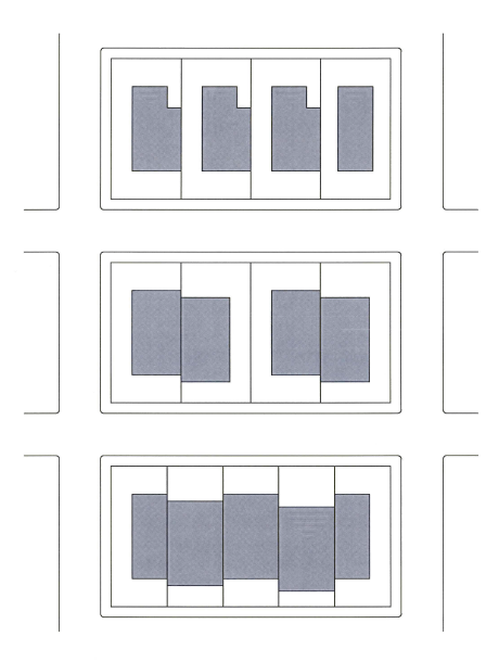
[Ord. 541 § 6 (Exh. 1), 2021; Ord. 532 § 2 (Att. B), 2020].
17.335.120 Multi-unit dwelling standards.
The purpose of these development standards is to ensure that multi-unit dwellings provide for a physical environment with visual interest consistent with the Coos Bay comprehensive plan land use chapter.
(1) Applicability.
(a) Multi-unit dwelling standards shall apply to all multi-unit developments in all zones. In cases where the multi-unit dwelling standards apply, they shall be considered applicable for the portion of the development site impacted by the proposed development.
(b) Multi-unit dwelling standards shall also apply to mixed use developments in commercial zones with the exception of storefronts, areas for lobbies (serving residential and commercial uses), stairs, elevators, and other nonresidential use areas.
(c) Multi-unit dwelling standards shall apply to cottage clusters, recreational vehicle parks, and tiny home communities.
(2) Building Height. The maximum building heights allowed are those permitted according to the applicable zoning district.
(3) Required Setbacks. The required building setbacks are those required in the applicable zoning district in addition to the following requirements:
(a) Street Frontage. On development sites that will result in 100 feet or more of public or private street frontage, at least 60 percent of the site frontage abutting the street (including required yards) shall be occupied by a building(s) or enhanced pedestrian space placed within 10 feet of the minimum front yard setback line. On development sites with less than 100 feet of public or private street frontage, at least 40 percent of the site width shall be occupied by a building(s) placed within 10 feet of the minimum front yard setback line. “Site width,” as used in this standard, shall not include areas of street frontage that have significant natural resources as mapped by the city, delineated wetlands, slopes greater than 20 percent, recorded easements, required fire lanes or other similar nonbuildable areas, as determined by the director. (See Figure 17.335.120(3)(a) – Multi-Unit Minimum Building Setback Along Streets.)
Figure 17.335.120(3)(a) – Multi-Unit Minimum Building Setback Along Streets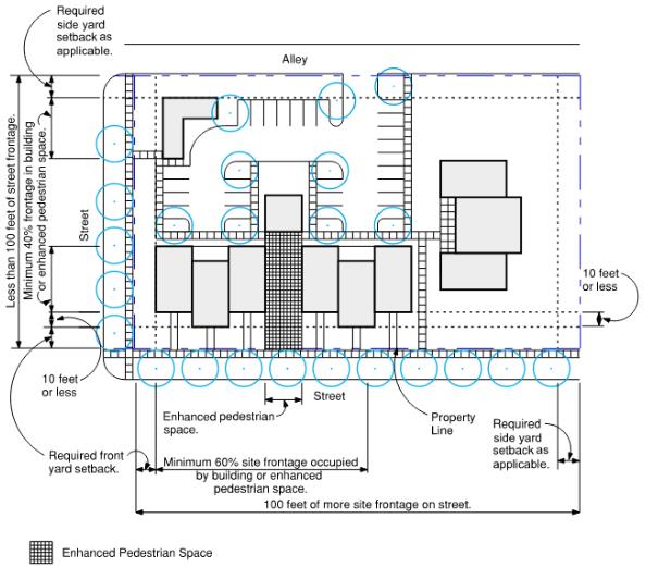
(b) Setback intrusions permitted are those required according to CBDC 17.335.130, Setbacks – Intrusions Permitted.
(4) Building Orientation and Entrances.
(a) Building Orientation. Multi-unit dwelling buildings located within 30 feet of a front lot line shall have the primary orientation toward the street. Buildings proposed to be side oriented to public streets due to access requirements, dimensional constraints and/or compatibility with other on-site buildings are exempt from this requirement.
(b) Ground Floor Building Entrances. An entrance(s) of ground floor units of any residential building located within 30 feet of a street must face the front lot line. Entrances may provide access to individual units, clusters of units, courtyard dwellings, or common lobbies. The following exceptions shall apply:
(i) On corner lots the main building entrance(s) may face either of the streets or be oriented to the corner.
(ii) For buildings that have more than one entrance serving multiple units, only one entrance must meet this requirement.
(iii) For buildings proposed to be oriented away from public streets due to access requirements, dimensional constraints and/or compatibility with other on-site buildings, main entries may face away from the street provided both of the following apply:
(A) There is an on-site pedestrian pathway between the new building entrance and the street. On-site pedestrian pathways shall be designed and constructed to provide a direct and clearly identified connection from the building entrance to the existing public right-of-way and public accessways.
(B) The ground floor building side facing the street shall contain windows that occupy a minimum of 10 percent of the facade.
(5) Building Mass and Facade.
(a) Maximum Building Dimension. Neither the maximum length nor width of any building within 30 feet of a front lot line can exceed 150 feet.
(b) Windows. Street facades shall contain windows covering a minimum of 10 percent of the facade on each floor level.
(6) Building Articulation.
(a) Articulation Requirement. To preclude large expanses of uninterrupted wall surfaces, exterior elevations of buildings shall incorporate design features such as offsets, projections, balconies, bays, windows, entries, porches, porticos, changes of material, varying roof heights or types, or similar elements. At least two of these design features shall be incorporated along the horizontal face (side to side) of the structure on each floor, to be repeated at intervals of no more than 20 feet.
(b) When offsets and projections are used to fulfill articulation requirements, the offset or projection shall vary from other wall surfaces by a minimum of two feet. Such changes in plane shall have a minimum width of six feet.
(c) Individual and common entry ways shall be covered by roofs, awnings, or porticos.
(7) Site Landscaping.
(a) Landscaping shall be installed consistent with CBDC 17.335.060, Landscaping. The required landscaping shall be placed within the required front yard setback area and may be pierced by pedestrian and vehicular access ways. All areas of a site not devoted to structures, driveways, or walkways shall be landscaped with lawn, trees, shrubs, or other plant materials, and shall be permanently maintained in a neat and orderly manner.
(8) Open Space. A minimum of 15 percent open space of the total site area shall be provided unless exempt under other provisions of the CBDC. Required open space may be provided as common open space and/or private open spaces with a minimum of 30 percent of the required open space shall be pervious area with living plant material.
(a) Common Open Space. Common open space may include any of the following:
(i) Outdoor areas incorporating:
(A) Lawn or hard surfaced areas to be used for active or passive recreation in which user amenities such as trees, shrubs, planters, pathways, tables, benches or drinking fountains have been placed.
(B) Ornamental or food gardens.
(C) Common open space for passive recreational use.
(D) Children’s play areas.
(E) Roof terraces, patios, porches, and internal courtyards.
(ii) Common open space may also include up to 30 percent of the required area in natural resource areas, such as steep slopes greater than 25 percent, forested areas, conservation areas and delineated wetlands provided the area includes passive walking trails meeting the following standards in Table 17.335.120(8)(a)(ii) – Common Open Space Natural Resource Areas:
|
Characteristic |
Requirement |
|---|---|
|
Width |
4' (with passing areas) – 10' |
|
Surface |
Soil, gravel, fiber (or engineered wood fiber equivalent), wood chips |
|
Longitudinal Slope |
0 – 5% (8% for max. 50') |
|
Cross-Slope |
2% |
|
Radius |
Aesthetic consideration |
|
Sight Distance |
N/A except road crossings |
|
Easement Width |
Tread + 10' min. |
|
Side Slope |
Varies |
(iii) Outdoor common open space shall comply with all of the following:
(A) The minimum area for any single outdoor common open space shall be 225 square feet.
(B) At least one area of outdoor common open space shall be a minimum of 15 feet by 15 feet.
(C) The minimum dimensions for any portion of outdoor common open space in the front yard setback shall be at least 15 feet by 15 feet. The minimum dimensions for any other portion of outdoor common open space shall be at least 10 feet by 10 feet.
(D) Required setback areas and areas required to comply with landscape standards may be applied toward the minimum open space requirements when the minimum dimensions of such space meet the standards in subsections (8)(a)(iii)(A) through (C) of this section.
(E) Outdoor common open spaces shall not be used as parking areas.
(b) Private Open Space. Private open space is outdoor space directly adjacent to a dwelling unit providing an outdoor area for private use by the occupants of the dwelling unit. Private open space, where provided, shall meet the minimum standards in Table 17.335.025(8)(b) – Minimum Private Open Space Sizes:
|
Location |
Minimum Area |
Minimum Dimension |
|---|---|---|
|
Ground Level |
100 square feet |
10 feet |
|
Balcony |
18 square feet |
3 feet |
|
Roof Terrace |
80 square feet |
8 feet |
(i) Balconies located within 20 feet of property zoned LDR and SLR shall not be counted as private open space.
(ii) To be counted toward the minimum required, private open space may be covered, but cannot be enclosed. Private open space is considered enclosed when the space between a floor, decking, or ground level and a roof structure has more than three sides taller than 42 inches in height.
(iii) Ground level private open space shall be screened or buffered from adjacent private open space and dwellings by landscape, fencing or partitions. Such screening or buffering shall be a minimum of 30 inches in height.
(c) Ground level common and private open space shall be physically separated and screened from adjacent parcels per CBDC 17.335.060, Landscaping.
(9) Block Requirements.
(a) Block Structure. Multi-unit developments eight or more acres in size shall be developed as a series of complete blocks bounded by public right-of-way or private drive aisles or streets. Natural areas, waterways, high voltage power lines, and other similar substantial physical features may form up to two sides of a block. The maximum block size within a multi-unit dwelling development shall be no greater than four acres in size. (See Figure 17.335.120(9)(a) – Multi-Unit Block Requirements.)
Figure 17.335.120(9)(a) – Multi-Unit Block Requirements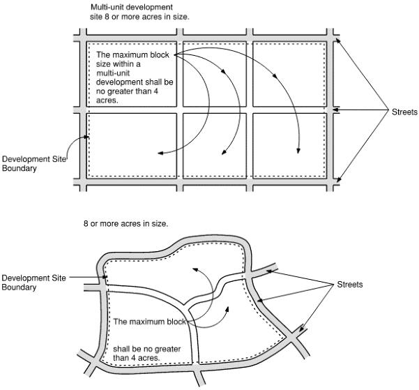
(10) On-Site Pedestrian Circulation.
(a) Multi-unit dwelling developments shall provide safe on-site pedestrian circulation designed and constructed to provide a direct connection to existing public right-of-way and public accessways.
(b) Multi-unit dwelling developments shall connect any new building entrances on a site to all other new and existing building entrances on the same site, except entrances used primarily for loading and unloading freight and egress only entrances.
(11) Recycling and Garbage Areas. Multi-unit developments shall provide screening for outdoor garbage and recycling collection areas according to CBDC 17.335.030, Solid waste.
(12) Lighting. Multi-unit dwelling developments shall provide exterior lighting according to CBDC 17.335.040, Lighting. [Ord. 540 § 6 (Exh. 1), 2021].
17.335.130 Setbacks – Intrusions permitted.
(1) Applicability. Except as restricted by easements or other restrictions on title, the intrusions in this section may project into required front, side and rear yard setbacks to the extent and under the conditions and limitations indicated.
(2) Depressed Areas. In any zone, fences, hedges, guard railings or other landscaping or devices for safety protection around depressed ramps, stairs or retaining walls, may be located in required setbacks; provided, that such devices are not more than 42 inches in height.
(3) Projecting Building and Site Features.
(a) Notwithstanding projection limitations authorized or limited by CBMC Title 15, intrusions permitted in setbacks include Table 17.335.130(3)(a) except as provided in subsection (3)(b) of this section:
|
Architectural Feature |
Setback |
||
|---|---|---|---|
|
Front |
Side |
Rear |
|
|
Awnings |
18 inches |
– |
18 inches |
|
Balconies |
48 inches |
– |
48 inches |
|
Bay windows, garden windows |
18 inches |
18 inches |
18 inches |
|
Chimneys |
18 inches |
18 inches |
18 inches |
|
Cornices, belt courses, buttresses, pilasters, pillars, sills |
12 inches |
12 inches |
12 inches |
|
Eaves |
24 inches |
24 inches |
24 inches |
|
Trellis structures and patio covers |
24 inches |
18 inches |
48 inches |
(b) Permitted Mechanical Equipment Projections. Mechanical equipment shall not be located within any required front or side yard setback and shall not be set back less than three feet from the rear lot line; however tankless water heaters may encroach 24 inches into interior side or rear yards.
(4) Fences and Walls. Fences and walls that conform with the standards required by the specific zones and CBDC 17.335.020 may be constructed in required front yard, side yard and rear yard setbacks.
(5) Public Bus Shelters. Public bus shelters may be located in required front yard, side yard and rear yard setbacks, provided vision clearance is maintained for vehicles passing on the street and leaving the development site.
(6) Driveways. Except as provided in Chapter 17.330 CBDC, Off-Street Parking and Loading Requirements and CBMC Title 15, driveways or accessways providing ingress and egress to or from parking spaces, parking areas, parking garages, or structured parking shall be permitted, together with any appropriate traffic control devices, in any required setback.
(7) Parking Spaces in Required Setbacks.
(a) Except as provided in Chapter 17.330 CBDC, Off-Street Parking and Loading Requirements, and CBMC Title 15, in areas with a broad zone category of residential, parking in required front, side and rear yard setbacks is permitted with the following restrictions:
(i) Parking spaces in required front yard setbacks are permitted in conjunction with a single-unit dwelling, accessory dwelling, or duplex, provided the parking spaces are located on driveways.
(ii) For lots and parcels with at least 50 feet of frontage, driveways shall cover a maximum of one-half of the area in the required front yard setback. All portions of required front yard setbacks not otherwise covered by legal driveways shall be landscaped and maintained.
(iii) Within the required front yard setback, recreational vehicles, boats, boat trailers, and other vehicles not in daily use, may only be parked on the paved driveway portion of the required front yard setback. No parking shall occur in the landscaped portion of the required front yard setback nor shall parking occur in the side yard. These vehicles not in daily use, are allowed to park in the front setback for not more than 48 consecutive hours.
(b) Except as provided in Chapter 17.330 CBDC, Off-Street Parking and Loading Requirements, and CBMC Title 15, in areas within the industrial commercial zone, parking spaces and parking areas are permitted in any required rear yard setback that is not adjacent to a residential or commercial zone.
(8) Utilities.
(a) Structures necessary for the operation and maintenance of public and private utilities may be located in required front yard, side yard and rear yard setbacks, provided these structures are screened as per CBDC 17.335.060, Landscaping, and vision clearance is maintained.
(b) With director approval, features such as below grade transformers, backflow prevention devices and closures, which have a low visual impact may be located in required front yard, side yard and rear yard setbacks, provided these structures are screened as per CBDC 17.335.060, Landscaping, and vision clearance is maintained.
(9) Poles. Poles for outdoor lights or government flags shall be permitted in any required setback. [Ord. 541 § 6 (Exh. 1), 2021].
17.335.140 Affordable housing incentives.
Development incentives are provided to encourage the development of affordable housing as supported in the Coos Bay comprehensive plan.
(1) Housing Location and Type. The incentives in this section may be considered in any zoning district where housing is permitted for the following housing types:
(a) Housing for Sale. Housing for which the mortgage, amortized interest, taxes, insurance, and condominium or association fees meet the United States Department of Housing and Urban Development (HUD) defined fair market sales prices in Coos County for HUD income eligible households.
(b) Housing for Rent. Housing for which the rent and related costs meet the HUD defined fair market rent for HUD income eligible households.
(2) Incentive Types. A variety of incentives may be considered by the city and may include but are not limited to the following:
(a) Density Bonus. A density bonus for affordable housing (as defined in Chapter 17.150 CBDC) may be authorized as a part of the land use review process but prior to the issuance of a building permit or recordation of a final map related to a development project for density bonuses specified in Table 17.335.140. The owner must enter into an affordable housing development agreement and execute any and all documents deemed necessary by the city in a form to be established by the city attorney, including, without limitation, restrictive covenants, deed restrictions, and related instruments (including requirements for income qualification for tenants of for-rent units) for the following:
(i) Ensure the timely completion of affordable housing.
(ii) Establish the length of time the units will remain affordable.
(iii) Related to units for sale, resale limitations to retain affordability for the duration of the agreement for individuals and families meeting the criteria of subsection (1)(a) of this section.
(iv) Related to units for rent, specific criteria related to retention of rental rates for affordability to individuals and families meeting the criteria in subsection (1) of this section.
|
Residential Zone |
Density Range |
Percent/number of affordable units based on maximum density |
|
|---|---|---|---|
|
For purposes of calculating maximum density, fractional units are rounded down to the next whole unit. For purposes of calculating the number of affordable units and density bonus units, fractional units are rounded up to the next whole unit.* |
10% |
20% |
|
|
Small lot residential (SLR) |
Max. 12 units/gross acre |
1 unit |
2 units |
|
Low density residential (LDR) |
Max. 10 units/gross acre |
NA |
1 unit |
|
Low density residential overlay (LDR-Overlay) |
Max. 16 units/gross acre |
2 units |
3 units |
|
Medium density residential (MDR) |
10 – 25 units/gross acre |
2 units |
5 units |
|
* For example, on a 10,000-square-foot lot, nine units are permitted. Of the nine units, the developer proposes 20 percent of the units to be affordable (nine units x 20 percent = 1.8 units, which is rounded up to two units). Therefore, of the nine units, two must be affordable. Since the applicant is proposing 20 percent of the units as affordable, the developer may receive a corresponding density bonus of 20 percent (nine units x 20 percent = 1.8 units, which is rounded up to two additional units). Therefore, the proposed project may have 11 units, two of which must be affordable. |
|||
(b) Residential Zone Building Height Incentive. An increase in building height not to exceed 10 feet above the height of the zoning district may be allowed for multi-unit dwellings when the additional units gained by the height increase are affordable housing units.
(c) Commercial Zone Building Height Incentive. An increase in building height not to exceed 52 feet above the height of the zoning district may be allowed for multi-unit dwelling when the additional units gained by the height increase are affordable housing units.
(d) Lot Coverage Incentive. For affordable housing developments where 50 percent or more of the dwelling units are deemed affordable in conformance with subsection (1) of this section the entire development may develop with an 80 percent lot coverage.
(e) Lot Area and Dimensions Incentive. For affordable housing developments where 50 percent or more of the dwelling units are deemed affordable in conformance with subsection (1) of this section, the required lot area and dimensions for the proposed lots or parcels may be reduced up to 30 percent for the entire residential development. For affordable housing developments where less than 50 percent of the dwelling units are deemed affordable in conformance with subsection (1) of this section, the required lot area and dimensions for the proposed affordable housing dwelling units’ lots or parcels may be reduced up to 30 percent.
(f) Parking Requirement Reduction. The parking requirement for affordable dwelling units is one on-site parking space per affordable dwelling unit. [Ord. 544 § 10 (Att. B), 2021; Ord. 541 § 6 (Exh. 1), 2021].
17.335.150 Solar use and placement.
The use of solar energy systems, both active and passive, including solar collectors, storage facilities, and other necessary components for space heating and cooling, swimming pool heating, and water heating is a permitted use in all districts subject to the requirements of CBMC Title 15. [Ord. 541 § 6 (Exh. 1), 2021].